Landslide Traces Inventory and Spatial Distribution Analysis Along the Hubei Section of the Jinsha River–Hubei Ultra-High-Voltage Transmission Line, China
Abstract
1. Introduction
2. Study Area
3. Data and Method
3.1. Remote Sensing Interpretation
- (1)
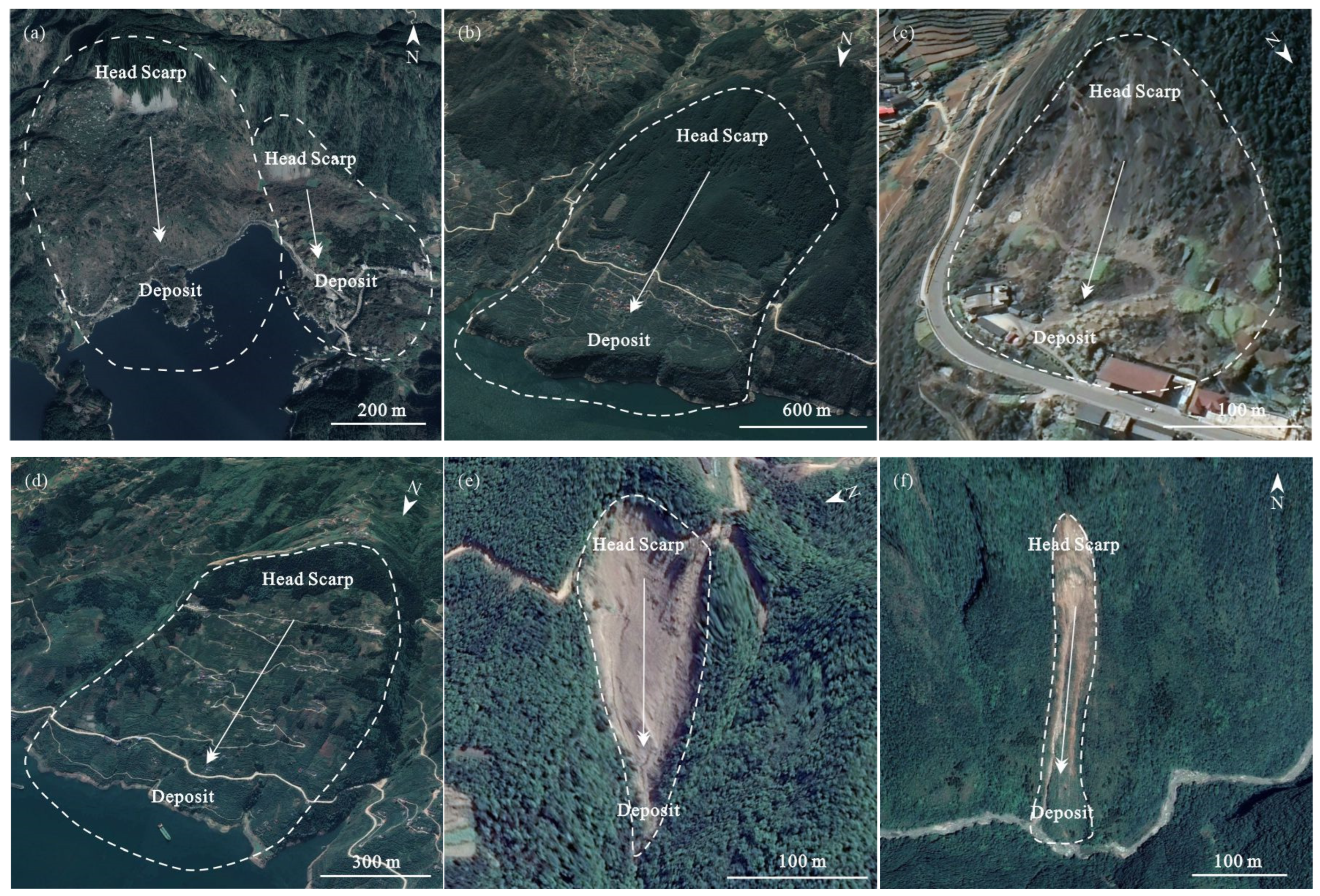
- Head scarp: Typically characterized by a steep scarp, generally exhibiting a chair-shaped or arcuate morphology, with downslope striations visible; tensile cracks nearly parallel to the slope surface are often observed on the back wall.
- (2)
- Lateral margins: Commonly developed along gullies or steep scarps, often showing the phenomenon of “two ditch troughs with the same origin”. Vegetation growth differs on both sides, with trees on the inner side sometimes showing tilting. Surface water infiltration or seepage may occur along the margins, and there are obvious differences in the occurrence and lithology of rock and soil on both sides.
- (3)
- Toe: Frequently presents as scarp-like, drum-shaped, or tongue-shaped. The shear outlet is often located at the lower edge of a terrace, and the rock and soil mass is squeezed or extruded.
- (4)
- In the process of interpretation, multiple geographic elements (e.g., rivers, roads, etc.) were superimposed in Google Earth for preliminary delineation. Typical landslides within the region were further validated using multi-source data (e.g., news reports, the literature), thereby improving accuracy and reducing misinterpretation.
3.2. Impact Factors
4. Results and Analysis
4.1. Landslide Traces Inventory
4.2. Spatial Distribution
4.3. Analysis of Influencing Factors
4.3.1. Topography and Geomorphological Factors
4.3.2. Geological Tectonic Factors
4.3.3. Hydrometeorological Factors
4.3.4. Surface Cover Factors
5. Discussion
5.1. Reliability of the Method
5.2. Completeness of the Landslide Inventory
5.3. Findings
5.4. Prospects
6. Conclusions
Author Contributions
Funding
Data Availability Statement
Acknowledgments
Conflicts of Interest
References
- Huang, C.; Yin, K.; Liang, X.; Gui, L.; Zhao, B.; Liu, Y. Study of direct and indirect risk assessment of landslide impacts on ultrahigh-voltage electricity transmission lines. Sci. Rep. 2024, 14, 25719. [Google Scholar] [CrossRef] [PubMed]
- Zhang, Y.; Yu, Y.; Ma, T. System optimization of long-distance energy transportation in China using ultra-high-voltage power transmission. J. Renew. Sustain. Energy 2018, 10, 045503. [Google Scholar] [CrossRef]
- Wang, S.; Zhuang, J.; Zheng, J.; Mu, J.; Wang, Y.; Fu, Y. Landslide susceptibility evaluation based on deep learning along Kangding-Litang section of CZ railway. J. Eng. Geol. 2022, 30, 908–919. [Google Scholar]
- Korup, O.; Densmore, A.L.; Schlunegger, F. The role of landslides in mountain range evolution. Geomorphology 2010, 120, 77–90. [Google Scholar] [CrossRef]
- Petley, D. Global patterns of loss of life from landslides. Geology 2012, 40, 927–930. [Google Scholar] [CrossRef]
- Yu, Q.; Guo, Y.; Bao, T.; Liu, Q.; Liu, F. Landslide Hazard to Transmission Line and Its Prevention and Treatment Measures. Sichuan Electr. Power Technol. 2023, 46, 6–11. [Google Scholar]
- Pennington, C.; Freeborough, K.; Dashwood, C.; Dijkstra, T.; Lawrie, K. The National Landslide Database of Great Britain: Acquisition, communication and the role of social media. Geomorphology 2015, 249, 44–51. [Google Scholar] [CrossRef]
- Hader, P.R.P.; Horta, I.T.L.G.; da Silva do Valle, V.A.; Irigaray, C. Hydro-Meteorological Landslide Inventory for Sustainable Urban Management in a Coastal Region of Brazil. Sustainability 2025, 17, 7487. [Google Scholar] [CrossRef]
- Othman, A.A.; Gloaguen, R. Automatic extraction and size distribution of landslides in Kurdistan region, NE Iraq. Remote Sens. 2013, 5, 2389–2410. [Google Scholar] [CrossRef]
- Delgado, F.; Zerathe, S.; Schwartz, S.; Mathieux, B.; Benavente, C. Inventory of large landslides along the Central Western Andes (ca. 15–20 S): Landslide distribution patterns and insights on controlling factors. J. S. Am. Earth Sci. 2022, 116, 103824. [Google Scholar] [CrossRef]
- Gnyawali, K.R.; Adhikari, B.R. Spatial relations of earthquake induced landslides triggered by 2015 Gorkha earthquake Mw = 7.8. In Proceedings of the Workshop on World Landslide Forum, Ljubljana, Slovenia, 29 May–2 June 2017; Springer: Berlin/Heidelberg, Germany, 2017; pp. 85–93. [Google Scholar]
- Xu, C.; Xu, X.; Yao, X.; Dai, F. Three (nearly) complete inventories of landslides triggered by the May 12, 2008 Wenchuan Mw 7.9 earthquake of China and their spatial distribution statistical analysis. Landslides 2014, 11, 441–461. [Google Scholar] [CrossRef]
- Lan, H.; Zhou, C.; Wang, L.; Zhang, H.; Li, R. Landslide hazard spatial analysis and prediction using GIS in the Xiaojiang watershed, Yunnan, China. Eng. Geol. 2004, 76, 109–128. [Google Scholar] [CrossRef]
- Shao, X.; Xu, C.; Li, L.; Yang, Z.; Yao, X.; Shao, B.; Liang, C.; Xue, Z.; Xu, X. Spatial analysis and hazard assessment of Large-scale ancient landslides around the reservoir area of Wudongde Hydropower Station, China. Nat. Hazards 2024, 120, 87–105. [Google Scholar] [CrossRef]
- Wang, H.; Tan, R.; Wang, X. Investigation of Geological Disasters for Safe Operation of Hubei Power Grid. J. Green Sci. Technol. 2014, 2, 220–222. [Google Scholar]
- Guzzetti, F.; Mondini, A.C.; Cardinali, M.; Fiorucci, F.; Santangelo, M.; Chang, K.-T. Landslide inventory maps: New tools for an old problem. Earth-Sci. Rev. 2012, 112, 42–66. [Google Scholar] [CrossRef]
- Brabb, E.E.; Harrod, B.L. Landslides: Extent and economic significance. In Proceedings of the 28th International Geological Congress: Symposium on Land Slides, Washington, DC, USA, 17 July 1989. [Google Scholar]
- Fan, X.; Scaringi, G.; Korup, O.; West, A.J.; van Westen, C.J.; Tanyas, H.; Hovius, N.; Hales, T.C.; Jibson, R.W.; Allstadt, K.E. Earthquake-induced chains of geologic hazards: Patterns, mechanisms, and impacts. Rev. Geophys. 2019, 57, 421–503. [Google Scholar] [CrossRef]
- Damm, B.; Klose, M. The landslide database for Germany: Closing the gap at national level. Geomorphology 2015, 249, 82–93. [Google Scholar] [CrossRef]
- Lainas, S.; Sabatakakis, N.; Koukis, G. Rainfall thresholds for possible landslide initiation in wildfire-affected areas of western Greece. Bull. Eng. Geol. Environ. 2016, 75, 883–896. [Google Scholar] [CrossRef]
- Borgatti, L.; Soldati, M. Landslides as a geomorphological proxy for climate change: A record from the Dolomites (northern Italy). Geomorphology 2010, 120, 56–64. [Google Scholar] [CrossRef]
- Du, J.; Glade, T.; Woldai, T.; Chai, B.; Zeng, B. Landslide susceptibility assessment based on an incomplete landslide inventory in the Jilong Valley, Tibet, Chinese Himalayas. Eng. Geol. 2020, 270, 105572. [Google Scholar] [CrossRef]
- Keefer, D.K. Investigating landslides caused by earthquakes—A historical review. Surv. Geophys. 2002, 23, 473–510. [Google Scholar] [CrossRef]
- Peng, D.; Xu, Q.; Qi, X.; Fan, X.; Dong, X.; Li, S.; Ju, Y. Study on early recognition of loess landslides based on field investigation. Inttern. J. Geohazards Environ. 2016, 2, 35–52. [Google Scholar] [CrossRef]
- Santangelo, á.; Cardinali, á.; Rossi, á.; Mondini, A.; Guzzetti, F. Remote landslide mapping using a laser rangefinder binocular and GPS. Nat. Hazards Earth Syst. Sci. 2010, 10, 2539–2546. [Google Scholar] [CrossRef]
- Martha, T.R.; van Westen, C.J.; Kerle, N.; Jetten, V.; Kumar, K.V. Landslide hazard and risk assessment using semi-automatically created landslide inventories. Geomorphology 2013, 184, 139–150. [Google Scholar] [CrossRef]
- Lei, T.; Zhang, Y.; Lv, Z.; Li, S.; Liu, S.; Nandi, A.K. Landslide inventory mapping from bitemporal images using deep convolutional neural networks. IEEE Geosci. Remote Sens. Lett. 2019, 16, 982–986. [Google Scholar] [CrossRef]
- Pham, T.M.; Do, N.; Pham, H.T.; Bui, H.T.; Do, T.T.; Hoang, M.V. CResU-Net: A method for landslide mapping using deep learning. Mach. Learn. Sci. Technol. 2024, 5, 035008. [Google Scholar] [CrossRef]
- Milledge, D.G.; Bellugi, D.G.; Watt, J.; Densmore, A.L. Automated determination of landslide locations after large trigger events: Advantages and disadvantages compared to manual mapping. Nat. Hazards Earth Syst. Sci. 2022, 22, 481–508. [Google Scholar] [CrossRef]
- Zhang, Z.; Zeng, R.; Meng, X.; Zhao, S.; Meng, X.; Yao, Y.; Wang, H.; Guo, W.; Chen, G.; Zhang, Y. Estimating landslide sliding distance based on an improved Heim sled model. Catena 2021, 204, 105401. [Google Scholar] [CrossRef]
- Guerriero, L.; Prinzi, E.P.; Calcaterra, D.; Ciarcia, S.; Di Martire, D.; Guadagno, F.M.; Ruzza, G.; Revellino, P. Kinematics and geologic control of the deep-seated landslide affecting the historic center of Buonalbergo, southern Italy. Geomorphology 2021, 394, 107961. [Google Scholar] [CrossRef]
- Ding, H.; Zhang, M.; Li, L. Interpreting landslides in the northwestern loess plateau using remote sensing images. Quat. Sci. 2011, 31, 1077–1085. [Google Scholar]
- Sato, H.; Harp, E. Interpretation of earthquake-induced landslides triggered by the 12 May 2008, M7.9 Wenchuan earthquake in the Beichuan area, Sichuan Province, China using satellite imagery and Google Earth. Landslides 2009, 6, 153–159. [Google Scholar] [CrossRef]
- Causes, L. Landslide Types and Processes; US Geological Survey: Reston, VA, USA, 2001.
- Xu, X.; Han, Z.; Yang, X.; Zhang, S.; Yu, G.; Zhou, B.; Li, F.; Ma, B.; Chen, G.; Ran, Y. Seismotectonic Map in China and Its Adjacent Regions; Seismological Press: Beijing, China, 2016. [Google Scholar]
- Wu, X.; Xu, X.; Yu, G.; Ren, J.; Yang, X.; Chen, G.; Xu, C.; Du, K.; Huang, X.; Yang, H. The China Active Faults Database (CAFD) and its web system. Earth Syst. Sci. Data 2024, 16, 3391–3417. [Google Scholar] [CrossRef]
- Tateishi, R.; Uriyangqai, B.; Al-Bilbisi, H.; Ghar, M.A.; Tsend-Ayush, J.; Kobayashi, T.; Kasimu, A.; Hoan, N.T.; Shalaby, A.; Alsaaideh, B. Production of global land cover data—GLCNMO. Int. J. Digit. Earth 2011, 4, 22–49. [Google Scholar] [CrossRef]
- Xu, C.; Xu, X.; Zhou, B.; Shen, L. Probability of coseismic landslides: A new generation of earthquake-triggered landslide hazard model. J. Eng. Geol. 2019, 27, 1122–1130. [Google Scholar]
- Tian, Y.; Xu, C.; Xu, X.; Chen, J. Detailed inventory mapping and spatial analyses to landslides induced by the 2013 Ms 6.6 Minxian earthquake of China. J. Earth Sci. 2016, 27, 1016–1026. [Google Scholar] [CrossRef]
- Liu, C.; Qi, S.; Tong, L.; An, G.; Li, X. Great landslides in Hmalaya mountain area and their occurrence with lithology. J. Eng. Geol. 2010, 18, 669–676. [Google Scholar]
- Iverson, R.M. Landslide triggering by rain infiltration. Water Resour. Res. 2000, 36, 1897–1910. [Google Scholar] [CrossRef]
- Zhao, Q.; Yu, L.; Li, X.; Peng, D.; Zhang, Y.; Gong, P. Progress and trends in the application of Google Earth and Google Earth Engine. Remote Sens. 2021, 13, 3778. [Google Scholar] [CrossRef]
- Zhu, L.; Kan, W.; Zhang, Y.; Sun, J. Visualizing the structure of the Earth’s lithosphere on the Google Earth virtual-globe platform. ISPRS Int. J. Geo-Inf. 2016, 5, 26. [Google Scholar] [CrossRef]
- Potere, D. Horizontal positional accuracy of Google Earth’s high-resolution imagery archive. Sensors 2008, 8, 7973–7981. [Google Scholar] [CrossRef]
- Shen, T.; Wang, Y.; Wu, L. Discrete element simulation analysis of formation mechanism of Xiaonanhai landslide in Chongqing city. Rock Soil Mech. 2014, 35, 667–675. [Google Scholar]
- Wang, J.; Li, Y.; Zhang, C. Dynamics Mechanism of Low-intensity Earthquake Triggered the Collapse of the Soft Rock: Xiao Nanhai Seismic Landslide in Chongqing of China as an Example. Mt. Res. 2016, 34, 200–207. [Google Scholar]
- Zhou, X.; Zhou, Q.; Gao, S.; Li, X. Restoration of the original topography of the Xiaonanhai landslide in Chongqing and calculation of its volume. Seismol. Geol. 2020, 42, 936–954. [Google Scholar]
- Zhou, X.; Zhou, Q.; Gao, S. Investigation to landslides triggered by the 1856 Qianjiang-Xianfeng (Daluba) earthquake and their generation mechanisms. Seismol. Geol. 2018, 40, 410–425. [Google Scholar]
- Chigira, M.; Wu, X.; Inokuchi, T.; Wang, G. Landslides induced by the 2008 Wenchuan earthquake, Sichuan, China. Geomorphology 2010, 118, 225–238. [Google Scholar] [CrossRef]
- Fan, W.; Wei, X.-S.; Cao, Y.-B.; Zheng, B. Landslide susceptibility assessment using the certainty factor and analytic hierarchy process. J. Mt. Sci. 2017, 14, 906–925. [Google Scholar] [CrossRef]
- Emberson, R.; Kirschbaum, D.B.; Amatya, P.; Tanyas, H.; Marc, O. Insights from the topographic characteristics of a large global catalog of rainfall-induced landslide event inventories. Nat. Hazards Earth Syst. Sci. 2022, 22, 1129–1149. [Google Scholar] [CrossRef]
- Malamud, B.D.; Turcotte, D.L.; Guzzetti, F.; Reichenbach, P. Landslide inventories and their statistical properties. Earth Surf. Process. Landf. 2004, 29, 687–711. [Google Scholar] [CrossRef]
- Guo, F.; Lai, P.; Huang, F.; Liu, L.; Wang, X.; He, Z. Literature review and research progress of landslide susceptibility mapping based on knowledge graph. Earth Sci. 2024, 49, 1584–1606. [Google Scholar]
- Guzzetti, F.; Malamud, B.D.; Turcotte, D.L.; Reichenbach, P. Power-law correlations of landslide areas in central Italy. Earth Planet. Sci. Lett. 2002, 195, 169–183. [Google Scholar] [CrossRef]
- Van Den Eeckhaut, M.; Poesen, J.; Govers, G.; Verstraeten, G.; Demoulin, A. Characteristics of the size distribution of recent and historical landslides in a populated hilly region. Earth Planet. Sci. Lett. 2007, 256, 588–603. [Google Scholar] [CrossRef]
- Liu, S.; Yin, K.; Zhou, C.; Gui, L.; Liang, X.; Lin, W.; Zhao, B. Susceptibility assessment for landslide initiated along power transmission lines. Remote Sens. 2021, 13, 5068. [Google Scholar] [CrossRef]
- Byron, E.; Nelson, P.A.; Mountain-Plains Consortium. Probabilistic Modeling of Landslide Hazards to Improve the Resilience of Transportation Infrastructure; Mountain-Plains Consortium: Fargo, ND, USA, 2023. [Google Scholar]
- Jin, B.; Zeng, T.; Liu, S.; Li, Y.; Gui, L.; Zhao, B.; Yin, K.; Catani, F.; Peduto, D. Quantitative risk assessment for rainfall-induced landslides of transmission line towers: The case of Chongqing National transmission protection regions. Int. J. Disaster Risk Reduct. 2025, 128, 105715. [Google Scholar] [CrossRef]
- de Toledo, J.J.; Magnusson, W.E.; Castilho, C.V.; Nascimento, H.E. Tree mode of death in Central Amazonia: Effects of soil and topography on tree mortality associated with storm disturbances. For. Ecol. Manag. 2012, 263, 253–261. [Google Scholar] [CrossRef]
- Cushman, K.; Detto, M.; García, M.; Muller-Landau, H.C. Soils and topography control natural disturbance rates and thereby forest structure in a lowland tropical landscape. Ecol. Lett. 2022, 25, 1126–1138. [Google Scholar] [CrossRef]

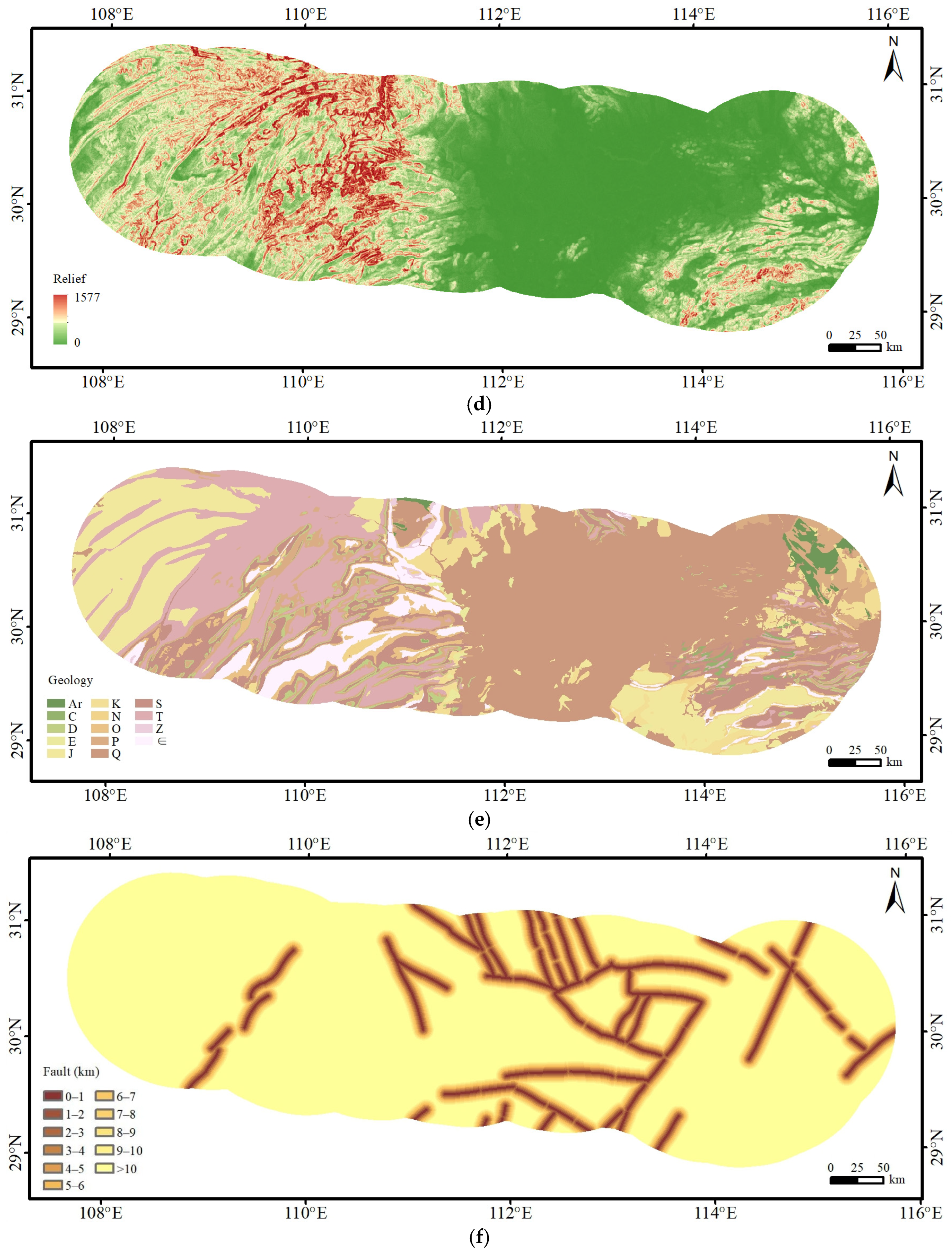

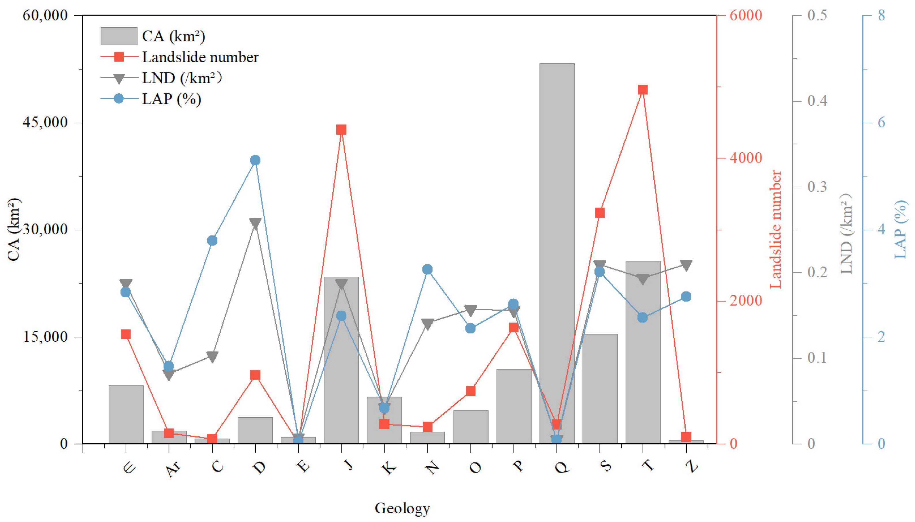

| NO. | Stratigraphic Chronology | Lithologic Classification |
|---|---|---|
| 1 | Archean (Ar) | Gneiss, Marble, Calc–Silicate Rock |
| 2 | Carboniferous (C) | Limestone, Shale, Sandstone |
| 3 | Devonian (D) | Sandstone, Shale, Quartzite |
| 4 | Paleogene (E) | Sandstone, Conglomerate, Shale |
| 5 | Jurassic (J) | Sandstone, Shale |
| 6 | Cretaceous (K) | Sandstone, Shale |
| 7 | Neogene (N) | Sandstone, Conglomerate |
| 8 | Ordovician (O) | Black Shale, Argillaceous Limestone, Limestone |
| 9 | Permian (P) | Limestone, Shale, Sandstone |
| 10 | Quaternary (Q) | Mud, Sand, and Other Sediments |
| 11 | Silurian (S) | Sandstone, Shale, Argillaceous Limestone |
| 12 | Triassic (T) | Limestone, Shale, Sandstone |
| 13 | Sinian (Z) | Dolomite, Shale, Limestone |
| 14 | Cambrian (∈) | Dolomite, Shale, Limestone |
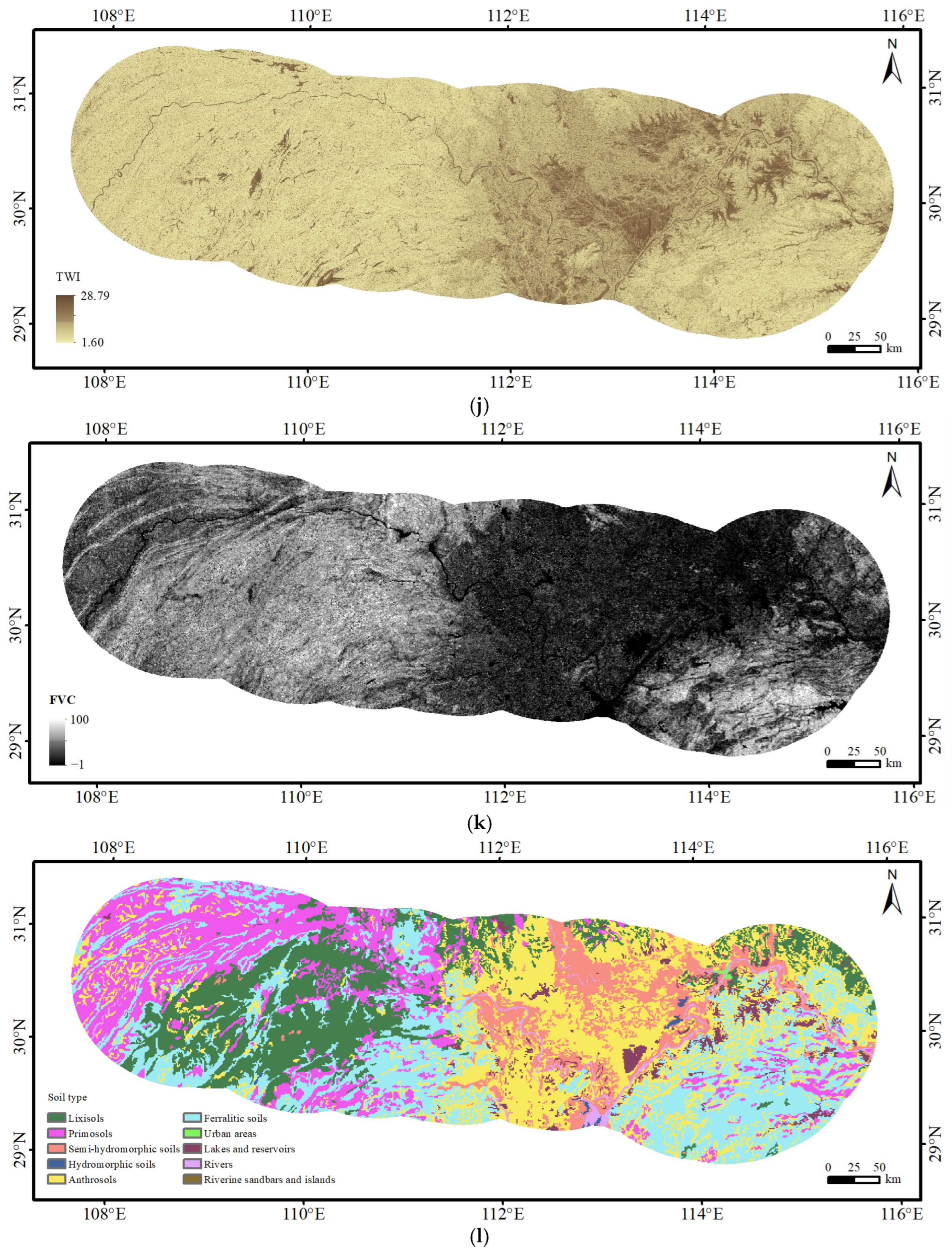
| Impact Factor | Data Type | Data Source |
|---|---|---|
| DEM | Raster | ALOS 30 m |
| Slope | Raster | Derived from DEM |
| Aspect | Raster | Derived from DEM |
| Relief | Raster | Derived from DEM |
| Topographic Wetness Index (TWI) | Raster | Derived from DEM |
| Geology | Vector | 1:2.5 M Geological Map |
| Fault | Vector | National Seismic Fault Data |
| Peak Ground Acceleration (PGA) | Raster | 5th Generation Seismic Zoning |
| Precipitation | Raster | Global Climate Data |
| River | Vector | National Geographic Information Resource Directory Service System |
| Fractional Vegetation Cover (FVC) | Raster | GLCNMO |
| Soil type | Raster | 1:1 M soil map of the People’s Republic of China |
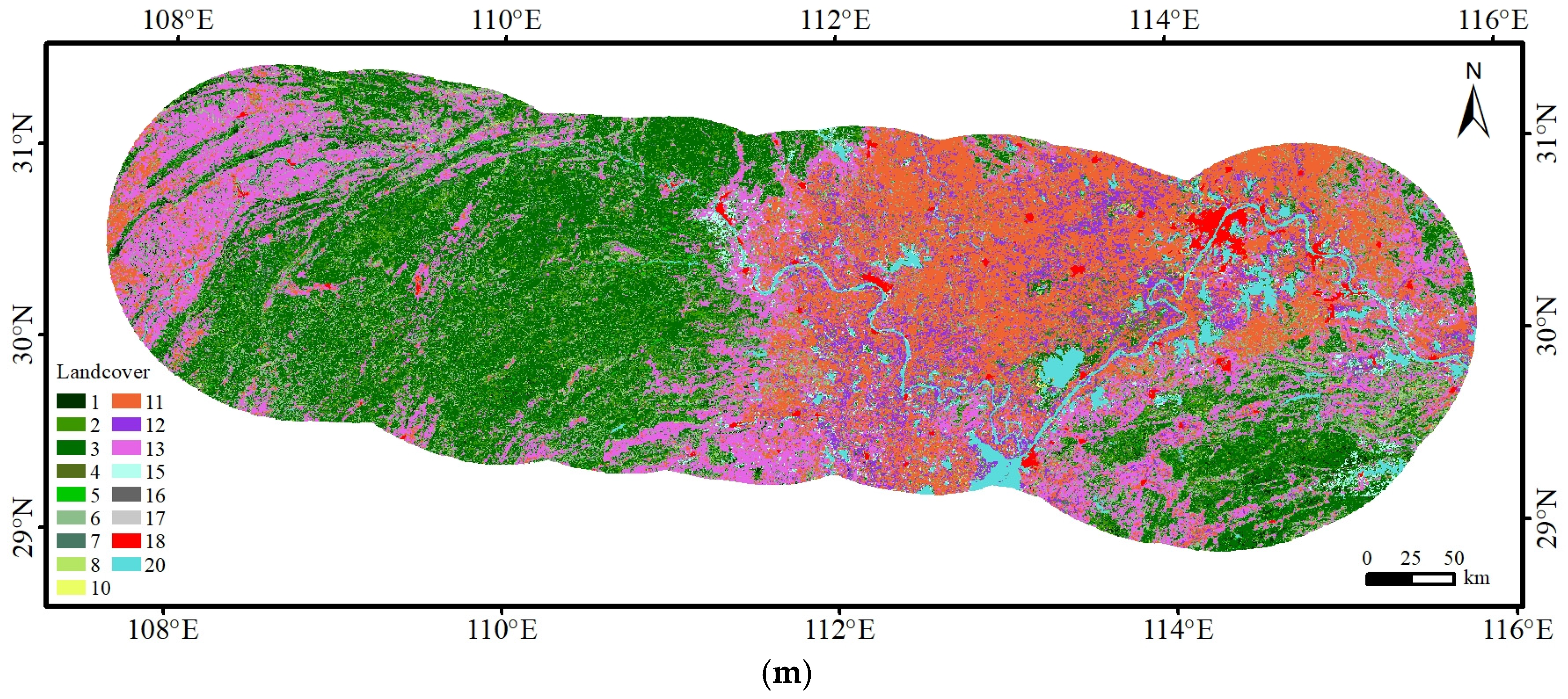
| Land cover | Raster | GLCNMO |
Disclaimer/Publisher’s Note: The statements, opinions and data contained in all publications are solely those of the individual author(s) and contributor(s) and not of MDPI and/or the editor(s). MDPI and/or the editor(s) disclaim responsibility for any injury to people or property resulting from any ideas, methods, instructions or products referred to in the content. |
© 2025 by the authors. Licensee MDPI, Basel, Switzerland. This article is an open access article distributed under the terms and conditions of the Creative Commons Attribution (CC BY) license (https://creativecommons.org/licenses/by/4.0/).
Share and Cite
Yang, W.; Xu, C.; Li, T.; Sun, J.; Li, L.; Feng, L.; Wang, P.; Chen, J.; Xiao, Z. Landslide Traces Inventory and Spatial Distribution Analysis Along the Hubei Section of the Jinsha River–Hubei Ultra-High-Voltage Transmission Line, China. Forests 2025, 16, 1686. https://doi.org/10.3390/f16111686
Yang W, Xu C, Li T, Sun J, Li L, Feng L, Wang P, Chen J, Xiao Z. Landslide Traces Inventory and Spatial Distribution Analysis Along the Hubei Section of the Jinsha River–Hubei Ultra-High-Voltage Transmission Line, China. Forests. 2025; 16(11):1686. https://doi.org/10.3390/f16111686
Chicago/Turabian StyleYang, Wenhui, Chong Xu, Tao Li, Jingjing Sun, Lei Li, Liye Feng, Peng Wang, Jingyu Chen, and Zikang Xiao. 2025. "Landslide Traces Inventory and Spatial Distribution Analysis Along the Hubei Section of the Jinsha River–Hubei Ultra-High-Voltage Transmission Line, China" Forests 16, no. 11: 1686. https://doi.org/10.3390/f16111686
APA StyleYang, W., Xu, C., Li, T., Sun, J., Li, L., Feng, L., Wang, P., Chen, J., & Xiao, Z. (2025). Landslide Traces Inventory and Spatial Distribution Analysis Along the Hubei Section of the Jinsha River–Hubei Ultra-High-Voltage Transmission Line, China. Forests, 16(11), 1686. https://doi.org/10.3390/f16111686


