
Multi-Scenario Ecological Network Conservation Planning Based on Climate and Land Changes: A Multi-Species Study in the Southeast Qinghai–Tibet Plateau


Abstract
1. Introduction
2. Materials and Methods
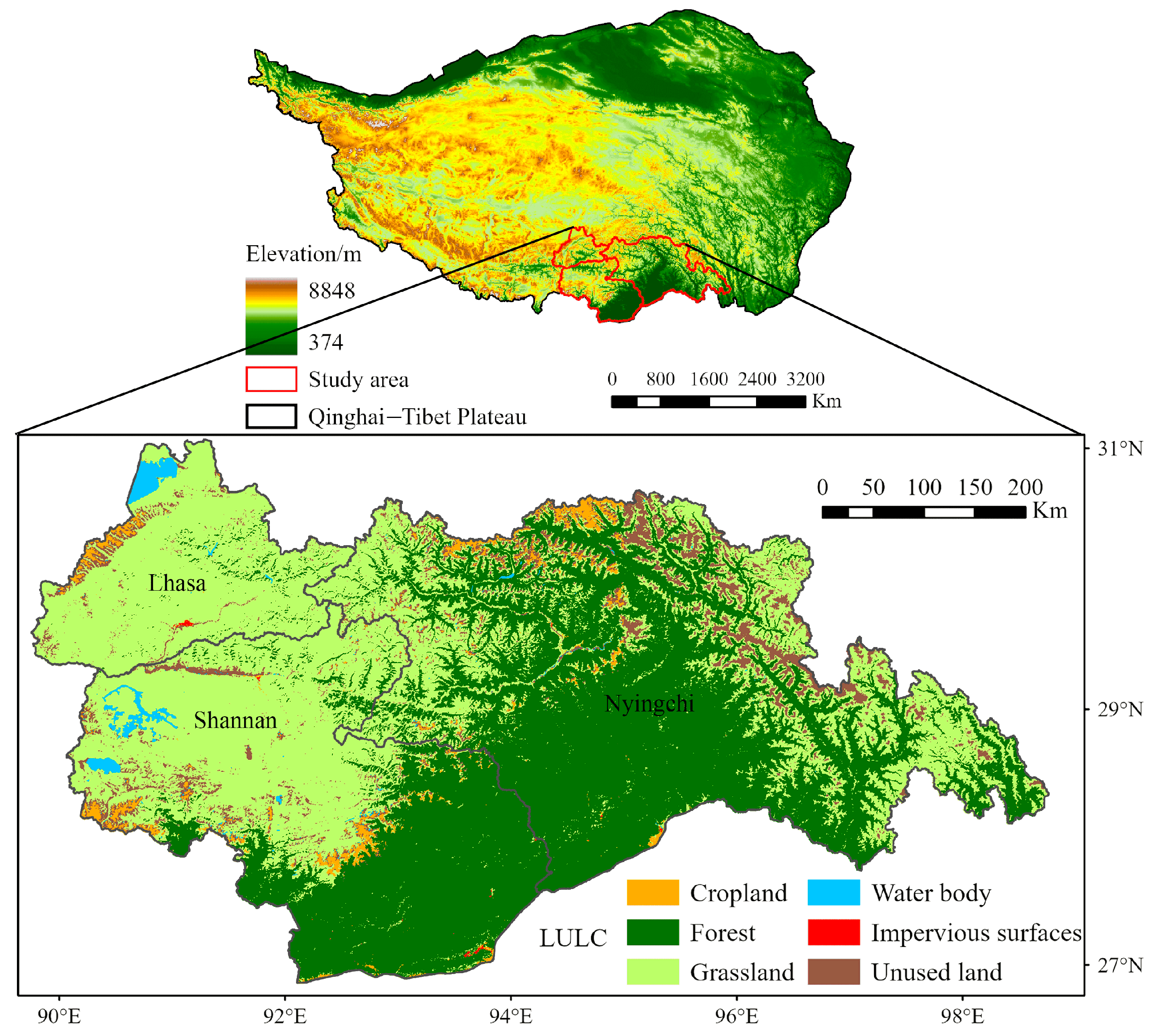
2.1. Study Area
2.2. Data Sources
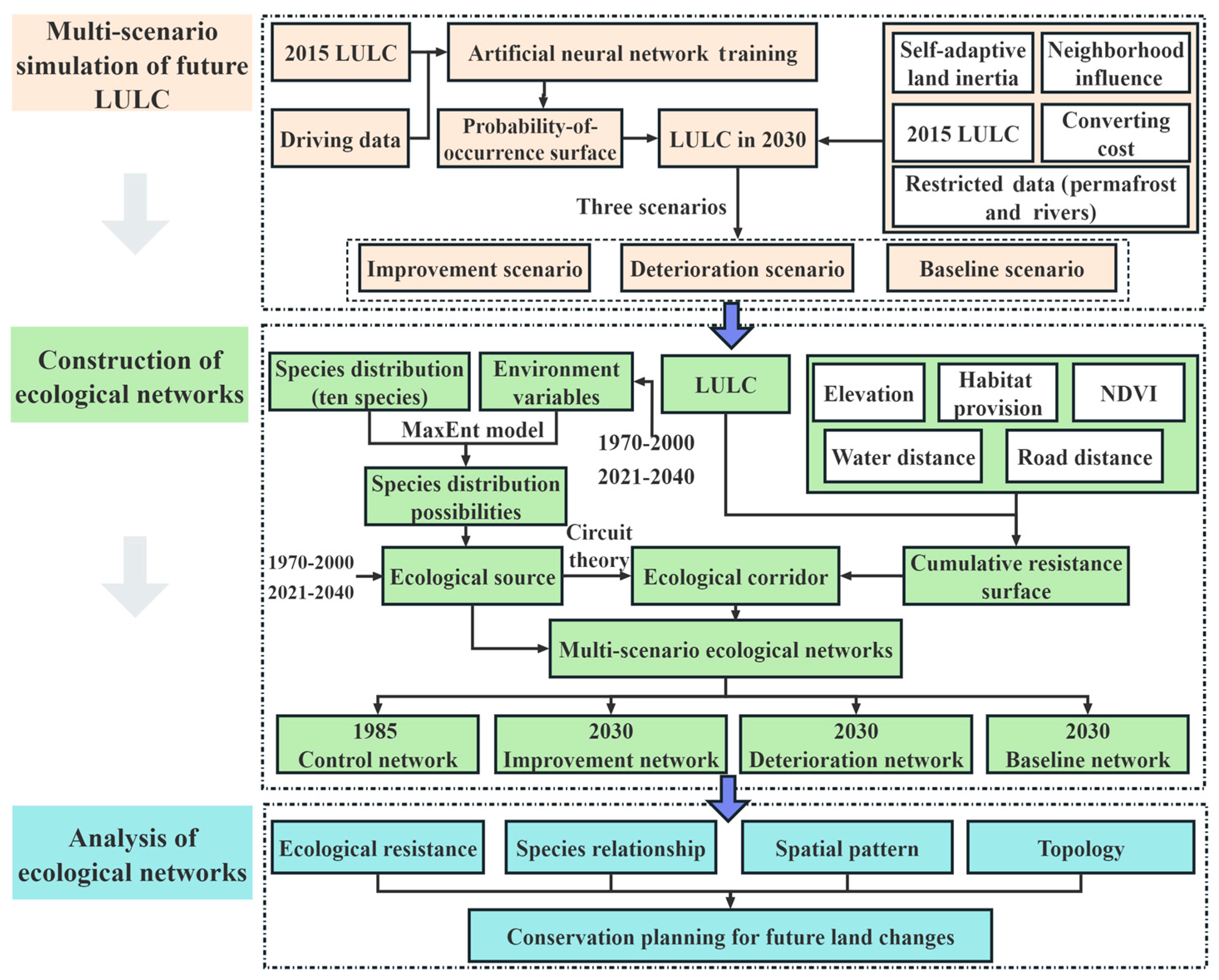
2.3. Research Framework
2.4. Multi-Scenario Prediction of LULC
2.4.1. Future Land Use Simulation Model
2.4.2. Multi-Scenario Setting
- (1)
- Improvement scenario: assume that forest land maintains its previous growth rate, grassland degradation is improved, and water bodies are designated as restricted conversion areas, while other land types convert randomly.
- (2)
- Deterioration scenario: abandon the protection of ecological land such as forests, grasslands, and water bodies, allowing these areas to be converted into other land types.
- (3)
- Baseline scenario: all land types continue their previous trends, with forest area increasing and grassland area continuing to decrease.
2.5. Construction of Multi-Scenario Ecological Networks
2.5.1. Identification of Ecological Source
2.5.2. Construction of Resistance Surface
2.5.3. Extraction of Ecological Corridor
2.6. Analysis of Multi-Scenario Ecological Networks
3. Results
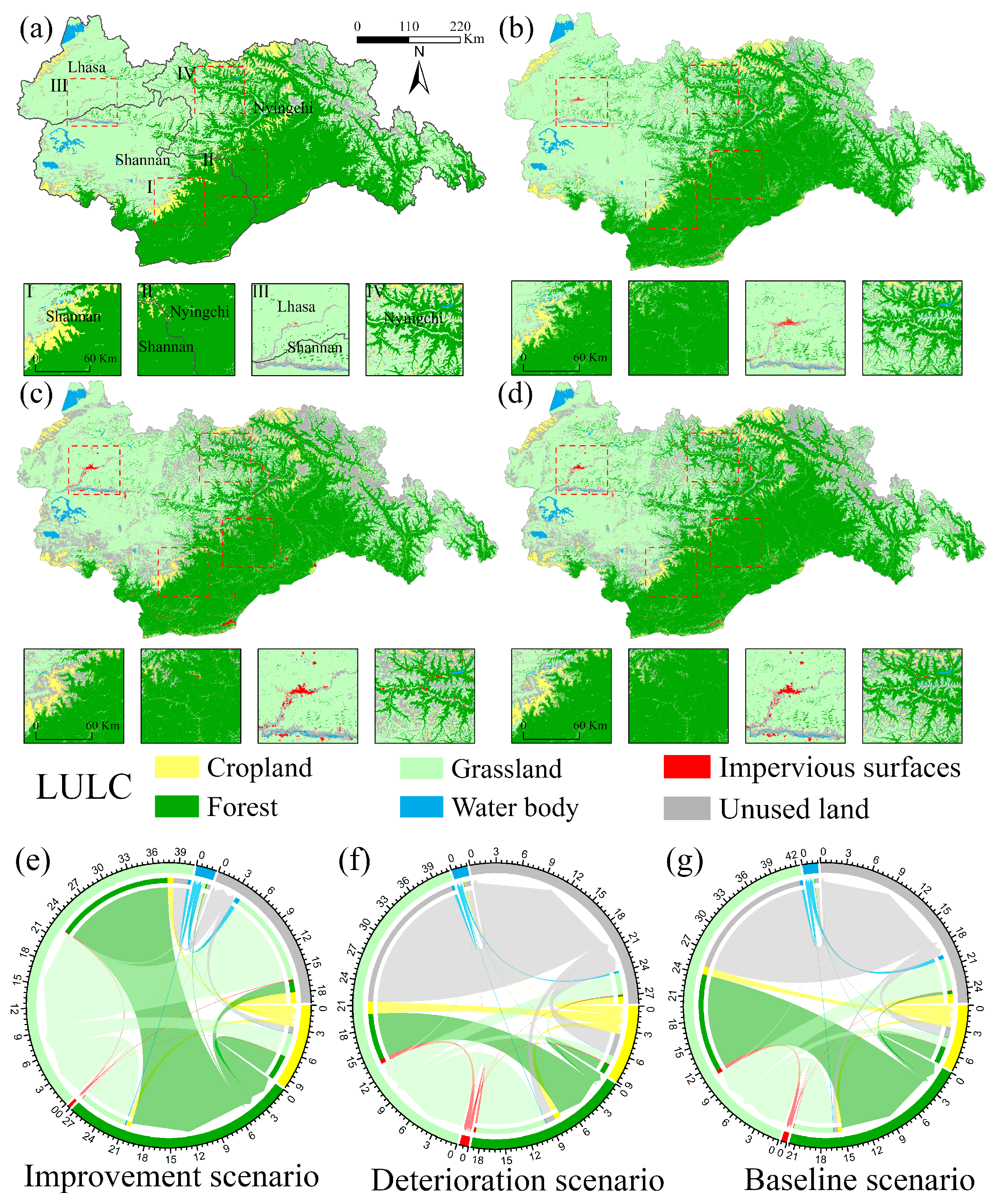
3.1. Spatio-Temporal Changes of LULC Pattern in SE-QTP
3.2. Spatial Distribution of Ecological Network in SE-QTP
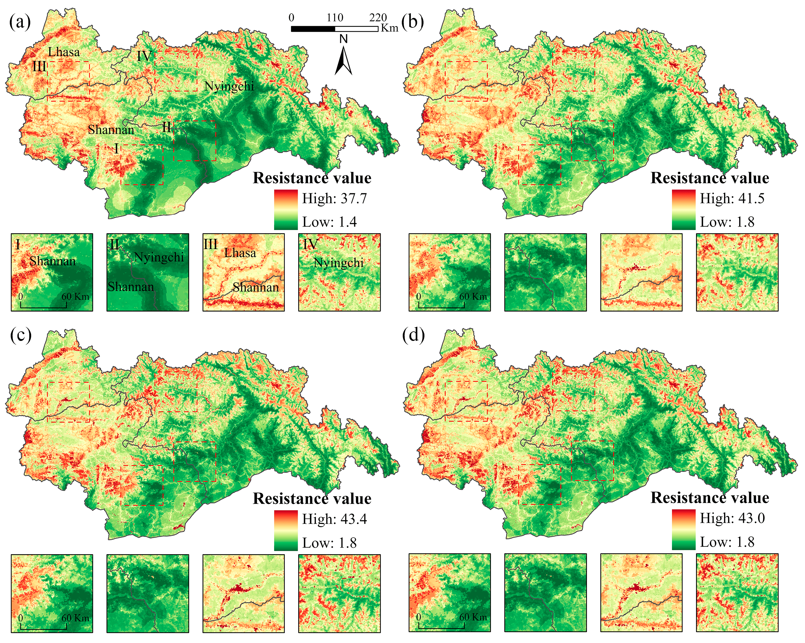
3.2.1. Spatial Distribution of Resistance Surface
3.2.2. Spatial Distribution of Habitat Suitability
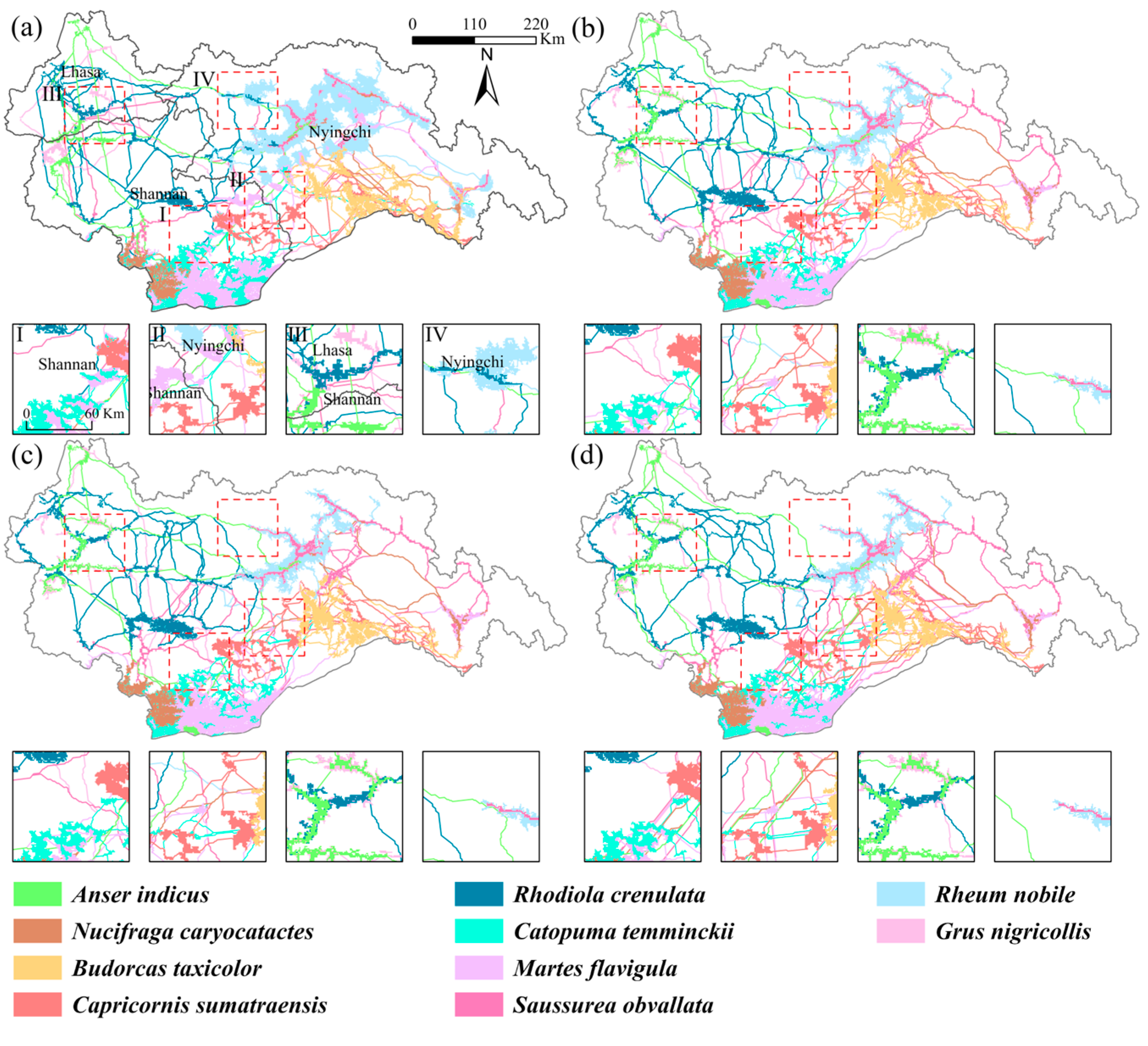
3.2.3. Spatial Distribution of Ecological Network
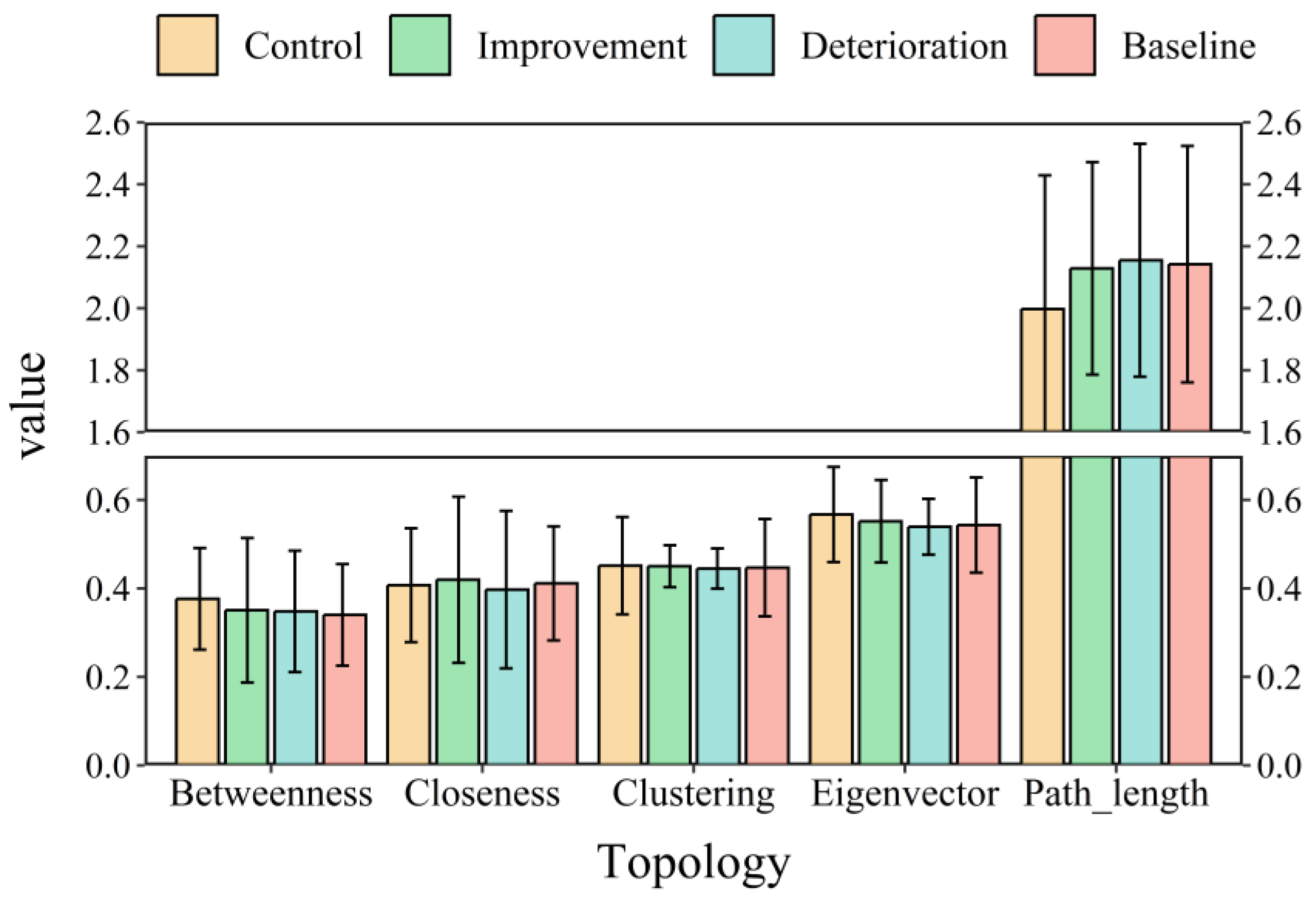
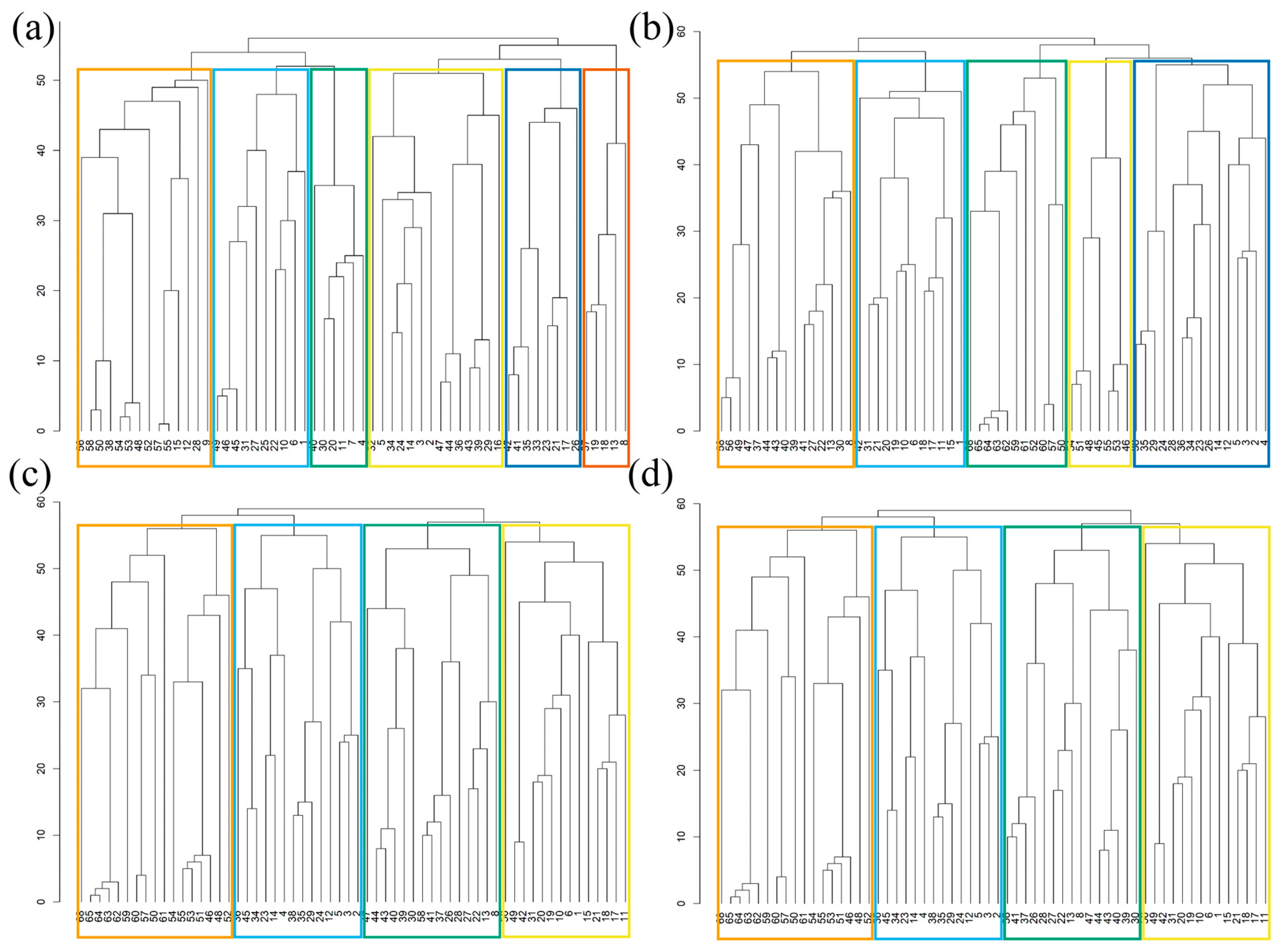
3.2.4. Changes in HA-EN Topology Indicators
4. Discussion
4.1. Discussion on Multi-Scenario Network
4.2. Multi-Scenario Conservation Pattern
4.3. Shortcomings and Prospects
5. Conclusions
- Resistance distribution characteristics: The western and northern parts of the study area exhibit high ecological resistance, while the central and southeastern parts exhibit low ecological resistance. With changes in climate and LULC, high-resistance areas continuously expand outward, and low-resistance areas continuously shrink. Under different scenarios, the ecological resistance of the improvement scenario is significantly better than that of the deterioration and baseline scenarios, yet there is still a significant difference compared to the baseline year of 1985.
- Changes in habitats and corridors: By 2030, the area of species’ habitats will have decreased by 12.9%, while the length of ecological corridors will have significantly increased under various scenarios. Changes in climate and LULC not only lead to a reduction in the area of suitable habitats for species but may also further increase the difficulty of species communication between habitats. Although the network topology indicators of the improvement scenario are better than those of the deterioration and baseline scenarios, there remains a significant difference compared to the baseline year of 1985.
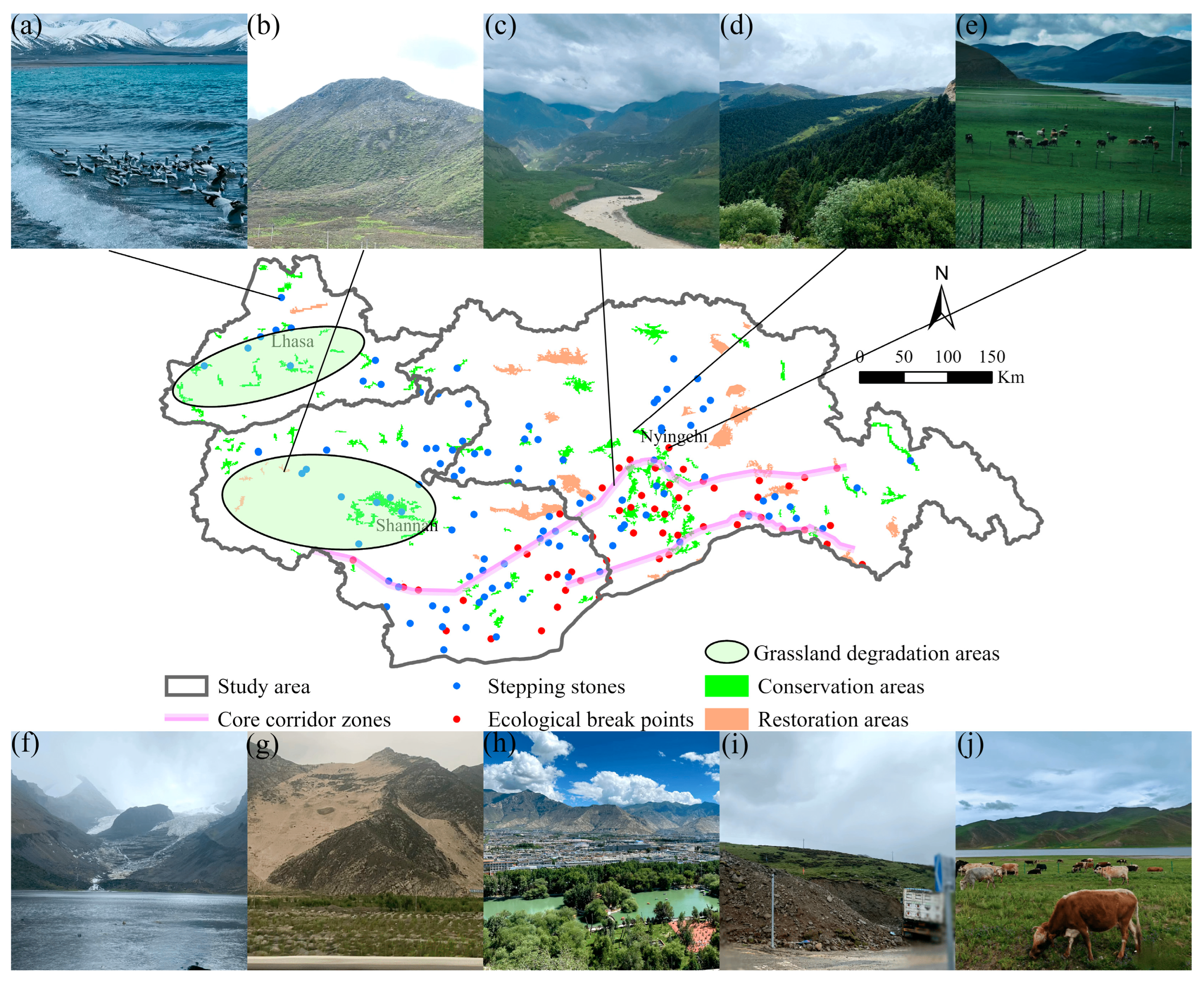
- Ecological protection planning: By optimizing the spatial layout of ecological elements, we propose a zoning and layout scheme of “two points, two cores, two belts, and two areas.” The regional hotspots are mainly located along corridors passing through areas of human activity and the edges of core habitats. This planning is based on the heterogeneity of the ecological space network and aims to enhance the connectivity of the HA-EN and the stability of species habitats.
Supplementary Materials
Author Contributions
Funding
Data Availability Statement
Acknowledgments
Conflicts of Interest
References
- Heller, N.E.; Zavaleta, E.S. Biodiversity management in the face of climate change: A review of 22 years of recommendations. Biol. Conserv. 2009, 142, 14–32. [Google Scholar] [CrossRef]
- Scheffers, B.R.; De Meester, L.; Bridge, T.C.L.; Hoffmann, A.A.; Pandolfi, J.M.; Corlett, R.T.; Butchart, S.H.M.; Pearce-Kelly, P.; Kovacs, K.M.; Dudgeon, D.; et al. The broad footprint of climate change from genes to biomes to people. Science 2016, 354, aaf7671. [Google Scholar] [CrossRef] [PubMed]
- Xu, W.B.; Svenning, J.-C.; Chen, G.K.; Zhang, M.G.; Huang, J.H.; Chen, B.; Ordonez, A.; Ma, K.P. Human activities have opposing effects on distributions of narrow-ranged and widespread plant species in China. Proc. Natl. Acad. Sci. USA 2019, 116, 26674–26681. [Google Scholar] [CrossRef]
- Di Marco, M.; Santini, L. Human pressures predict species’ geographic range size better than biological traits. Glob. Chang. Biol. 2015, 21, 2169–2178. [Google Scholar] [CrossRef]
- Fei, S.L.; Desprez, J.M.; Potter, K.M.; Jo, I.; Knott, J.A.; Oswalt, C.M. Divergence of species responses to climate change. Sci. Adv. 2017, 3, e1603055. [Google Scholar] [CrossRef]
- Bay, R.A.; Harrigan, R.J.; Underwood, V.L.; Gibbs, H.L.; Smith, T.B.; Ruegg, K. Genomic signals of selection predict climate-driven population declines in a migratory bird. Science 2018, 359, 83–86. [Google Scholar] [CrossRef]
- Ceballos, G.; Ehrlich, P.R. Mammal Population Losses and the Extinction Crisis. Science 2002, 296, 904–907. [Google Scholar] [CrossRef]
- Bucciarelli, G.M.; Clark, M.A.; Delaney, K.S.; Riley, S.P.D.; Shaffer, H.B.; Fisher, R.N.; Honeycutt, R.L.; Kats, L.B. Amphibian responses in the aftermath of extreme climate events. Sci. Rep. 2020, 10, 3409. [Google Scholar] [CrossRef] [PubMed]
- Luedtke, J.A.; Chanson, J.; Neam, K.; Hobin, L.; Maciel, A.O.; Catenazzi, A.; Borzée, A. Ongoing declines for the world’s amphibians in the face of emerging threats. Nature 2023, 622, 308–314. [Google Scholar] [CrossRef] [PubMed]
- Liu, Y.C.; Li, Z.; Chen, Y.N. Continuous warming shift greening towards browning in the Southeast and Northwest High Mountain Asia. Sci. Rep. 2021, 11, 17920. [Google Scholar] [CrossRef]
- Yao, T.; Thompson, L.G.; Mosbrugger, V.; Zhang, F.; Ma, Y.; Luo, T.; Xu, B.; Yang, X.; Joswiak, D.R.; Wang, W.; et al. Third Pole Environment (TPE). Environ. Dev. 2012, 3, 52–64. [Google Scholar] [CrossRef]
- Qiu, J. China: The third pole. Nature 2008, 454, 393–396. [Google Scholar] [CrossRef]
- Fath, B.D.; Scharler, U.M.; Ulanowicz, R.E.; Hannon, B. Ecological network analysis: Network construction. Ecol. Model. 2007, 208, 49–55. [Google Scholar] [CrossRef]
- Hüse, B.; Szabó, S.; Deák, B.; Tóthmérész, B. Mapping an ecological network of green habitat patches and their role in maintaining urban biodiversity in and around Debrecen city (Eastern Hungary). Land Use Policy 2016, 57, 574–581. [Google Scholar] [CrossRef]
- Wang, S.; Wu, M.Q.; Hu, M.M.; Fan, C.; Wang, T.; Xia, B.C. Promoting landscape connectivity of highly urbanized area: An ecological network approach. Ecol. Indic. 2021, 125, 107487. [Google Scholar] [CrossRef]
- Verburg, P.H.; Schot, P.P.; Dijst, M.J.; Veldkamp, A. Land use change modelling: Current practice and research priorities. GeoJournal 2004, 61, 309–324. [Google Scholar] [CrossRef]
- Schulp, C.J.E.; Nabuurs, G.-J.; Verburg, P.H. Future carbon sequestration in Europe—Effects of land use change. Agric. Ecosyst. Environ. 2008, 127, 251–264. [Google Scholar] [CrossRef]
- Liu, X.; Liang, X.; Li, X.; Xu, X.; Ou, J.; Chen, Y.; Li, S.; Wang, S.; Pei, F. A future land use simulation model (FLUS) for simulating multiple land use scenarios by coupling human and natural effects. Landsc. Urban Plan. 2017, 168, 94–116. [Google Scholar] [CrossRef]
- Yin, H.W.; Kong, F.H.; Hu, Y.M. Assessing Growth Scenarios for Their Landscape Ecological Security Impact Using the SLEUTH Urban Growth Model. J. Urban Plan. Dev. 2016, 142, 05015006. [Google Scholar] [CrossRef]
- Fall, A.; Fortin, M.-J.; Manseau, M.; O’Brien, D. Spatial Graphs: Principles and Applications for Habitat Connectivity. Ecosystems 2007, 10, 448–461. [Google Scholar] [CrossRef]
- Urban, D.; Keitt, T. Landscape Connectivity: A Graph-Theoretic Perspective. Ecology 2001, 82, 1205–1218. [Google Scholar] [CrossRef]
- Jetz, W.; McGowan, J.; Rinnan, D.S.; Possingham, H.P.; Visconti, P.; O’Donnell, B.; Londoño-Murcia, M.C. Include biodiversity representation indicators in area-based conservation targets. Nat. Ecol. Evol. 2022, 6, 123–126. [Google Scholar] [CrossRef]
- Teng, M.; Wu, C.; Zhou, Z.; Lord, E.; Zheng, Z. Multipurpose greenway planning for changing cities: A framework integrating priorities and a least-cost path model. Landsc. Urban Plan. 2011, 103, 1–14. [Google Scholar] [CrossRef]
- Préau, C.; Grandjean, F.; Sellier, Y.; Gailledrat, M.; Bertrand, R.; Isselin-Nondedeu, F. Habitat patches for newts in the face of climate change: Local scale assessment combining niche modelling and graph theory. Sci. Rep. 2020, 10, 3570. [Google Scholar] [CrossRef]
- LaPoint, S.; Gallery, P.; Wikelski, M.; Kays, R. Animal behavior, cost-based corridor models, and real corridors. Landsc. Ecol. 2013, 28, 1615–1630. [Google Scholar] [CrossRef]
- Cushman, S.A.; Landguth, E.L.; Flather, C.H. Evaluating population connectivity for species of conservation concern in the American Great Plains. Biodivers. Conserv. 2013, 22, 2583–2605. [Google Scholar] [CrossRef]
- Bukvareva, E. The optimal biodiversity–A new dimension of landscape assessment. Ecol. Indic. 2018, 94, 6–11. [Google Scholar] [CrossRef]
- Taylor, P.D.; Fahrig, L.; Henein, K.; Merriam, G. Connectivity Is a Vital Element of Landscape Structure. Oikos 1993, 68, 571–573. [Google Scholar] [CrossRef]
- Tambosi, L.R.; Martensen, A.C.; Ribeiro, M.C.; Metzger, J.P. A Framework to Optimize Biodiversity Restoration Efforts Based on Habitat Amount and Landscape Connectivity. Restor. Ecol. 2014, 22, 169–177. [Google Scholar] [CrossRef]
- Hamonic, F.; Albert, C.; Couëtoux, B.; Vaxès, Y. Optimizing the ecological connectivity of landscapes. Networks 2023, 81, 278–293. [Google Scholar] [CrossRef]
- Pietsch, M. Contribution of connectivity metrics to the assessment of biodiversity—Some methodological considerations to improve landscape planning. Ecol. Indic. 2018, 94, 116–127. [Google Scholar] [CrossRef]
- Ricotta, C.; Stanisci, A.; Avena, G.C.; Blasi, C. Quantifying the network connectivity of landscape mosaics: A graph-theoretical approach. Community Ecol. 2000, 1, 89–94. [Google Scholar] [CrossRef]
- Saura, S.; Pascual-Hortal, L. A new habitat availability index to integrate connectivity in landscape conservation planning: Comparison with existing indices and application to a case study. Landsc. Urban Plan. 2007, 83, 91–103. [Google Scholar] [CrossRef]
- Keeley, A.T.H.; Ackerly, D.D.; Cameron, D.R.; Heller, N.E.; Huber, P.R.; Schloss, C.A.; Thorne, J.H.; Merenlender, A.M. New concepts, models, and assessments of climate-wise connectivity. Environ. Res. Lett. 2018, 13, 073002. [Google Scholar] [CrossRef]
- Bai, L.; Yao, Y.; Lei, X.; Liang, Z. Annual and Seasonal Variation Characteristics of Surface Temperature in the Qinghai–Tibetan Plateau. J. Geomat. 2018, 43, 15–18. [Google Scholar] [CrossRef]
- Luo, L.H.; Ma, W.; Zhuang, Y.L.; Zhang, Y.N.; Yi, S.H.; Xu, J.W.; Long, Y.P.; Ma, D.; Zhang, Z.Q. The impacts of climate change and human activities on alpine vegetation and permafrost in the Qinghai-Tibet Engineering Corridor. Ecol. Indic. 2018, 93, 24–35. [Google Scholar] [CrossRef]
- Dong, S.K. Revitalizing the grassland on the Qinghai–Tibetan Plateau. Grassl. Res. 2023, 2, 241–250. [Google Scholar] [CrossRef]
- Liang, X.; Liu, X.P.; Li, X.C.; Chen, Y.M.; Tian, H.; Yao, Y. Delineating multi-scenario urban growth boundaries with a CA-based FLUS model and morphological method. Landsc. Urban Plan. 2018, 177, 47–63. [Google Scholar] [CrossRef]
- Zhang, Y.; Zheng, M.R.; Qin, B. Optimization of spatial layout based on ESV-FLUS model from the perspective of “Production-Living-Ecological”: A case study of Wuhan City. Ecol. Model. 2023, 481, 110356. [Google Scholar] [CrossRef]
- Luo, H.Z.; Li, Y.Y.; Gao, X.Y.; Meng, X.Z.; Yang, X.H.; Yan, J.Y. Carbon emission prediction model of prefecture-level administrative region: A land-use-based case study of Xi’an city, China. Appl. Energy 2023, 348, 121488. [Google Scholar] [CrossRef]
- Wang, Q.Z.; Guan, Q.Y.; Sun, Y.F.; Du, Q.Q.; Xiao, X.; Luo, H.P.; Zhang, J.; Mi, J.M. Simulation of future land use/cover change (LUCC) in typical watersheds of arid regions under multiple scenarios. J. Environ. Manag. 2023, 335, 117543. [Google Scholar] [CrossRef] [PubMed]
- Jayanthi, M.; Duraisamy, M.; Thirumurthy, S.; Samynathan, M.; Muralidhar, M. Dynamics of land-use changes and their future trends using spatial analysis and the CA-Markov model—A case-study with a special emphasis on aquaculture development in India. Land Degrad. Dev. 2021, 32, 2563–2579. [Google Scholar] [CrossRef]
- Phillips, S.J.; Anderson, R.P.; Schapire, R.E. Maximum entropy modeling of species geographic distributions. Ecol. Model. 2006, 190, 231–259. [Google Scholar] [CrossRef]
- Qian, M.Y.; Huang, Y.T.; Cao, Y.R.; Wu, J.Y.; Xiong, Y.M. Ecological network construction and optimization in Guangzhou from the perspective of biodiversity conservation. J. Environ. Manag. 2023, 336, 117692. [Google Scholar] [CrossRef] [PubMed]
- Ortega-Andrade, H.M.; Prieto-Torres, D.A.; Gómez-Lora, I.; Lizcano, D.J. Ecological and Geographical Analysis of the Distribution of the Mountain Tapir (Tapirus pinchaque) in Ecuador: Importance of Protected Areas in Future Scenarios of Global Warming. PLoS ONE 2015, 10, e0121137. [Google Scholar] [CrossRef]
- Xu, C.L.; Yu, Q.; Wang, F.; Qiu, S.; Ai, M.S.; Zhao, J.K. Identifying and optimizing ecological spatial patterns based on the bird distribution in the Yellow River Basin, China. J. Environ. Manag. 2023, 348, 119293. [Google Scholar] [CrossRef]
- Jiang, H.; Peng, J.; Zhao, Y.N.; Xu, D.M.; Dong, J.Q. Zoning for ecosystem restoration based on ecological network in mountainous region. Ecol. Indic. 2022, 142, 109138. [Google Scholar] [CrossRef]
- Wang, L.Y.; Wang, S.Y.; Liang, X.F.; Jiang, X.B.; Wang, J.P.; Li, C.; Chang, S.H.; You, Y.F.; Su, K. How to Optimize High-Value GEP Areas to Identify Key Areas for Protection and Restoration: The Integration of Ecology and Complex Networks. Remote Sens. 2023, 15, 3420. [Google Scholar] [CrossRef]
- Li, C.; Su, K.; Liang, X.F. Identification of priority areas to provide insights for ecological protection planning: A case study in Hechi, China. Ecol. Indic. 2023, 154, 110738. [Google Scholar] [CrossRef]
- Chang, S.H.; Su, K.; Jiang, X.B. Impacts and Predictions of Urban Expansion on Habitat Connectivity Networks: A Multi-Scenario Simulation Approach. Forests 2023, 14, 2187. [Google Scholar] [CrossRef]
- Wang, Y.J.; Qu, Z.Y.; Zhong, Q.C.; Zhang, Q.P.; Zhang, L.; Zhang, R.; Yi, Y.; Zhang, G.L.; Li, X.C.; Liu, J.G. Delimitation of ecological corridors in a highly urbanizing region based on circuit theory and MSPA. Ecol. Indic. 2022, 142, 109258. [Google Scholar] [CrossRef]
- Wei, Q.Q.; Halike, A.; Yao, K.X.; Chen, L.M.; Balati, M. Construction and optimization of ecological security pattern in Ebinur Lake Basin based on MSPA-MCR models. Ecol. Indic. 2022, 138, 108857. [Google Scholar] [CrossRef]
- McRae, B.H. Isolation by Resistance. Evolution 2006, 60, 1551–1561. [Google Scholar] [CrossRef] [PubMed]
- McRae, B.H.; Beier, P. Circuit theory predicts gene flow in plant and animal populations. Proc. Natl. Acad. Sci. USA 2007, 104, 19885–19890. [Google Scholar] [CrossRef]
- Taylor, C.M.; Stutchbury, B.J.M. Effects of breeding versus winter habitat loss and fragmentation on the population dynamics of a migratory songbird. Ecol. Appl. 2016, 26, 424–437. [Google Scholar] [CrossRef]
- Xu, Y.; Si, Y.; Wang, Y.; Zhang, Y.; Prins, H.H.T.; Cao, L.; de Boer, W.F. Loss of functional connectivity in migration networks induces population decline in migratory birds. Ecol. Appl. 2019, 29, e01960. [Google Scholar] [CrossRef]
- Fan, Z. Simulation of land-cover change in Jing-Jin-Ji region under different scenarios of SSP-RCP. J. Geogr. Sci. 2022, 32, 421–440. [Google Scholar] [CrossRef]
- Shen, Z.; Wu, W.; Chen, S.; Tian, S.; Wang, J.; Li, L. A static and dynamic coupling approach for maintaining ecological networks connectivity in rapid urbanization contexts. J. Clean. Prod. 2022, 369, 133375. [Google Scholar] [CrossRef]
- Zeller, K.A.; Lewison, R.; Fletcher, R.J.; Tulbure, M.G.; Jennings, M.K. Understanding the Importance of Dynamic Landscape Connectivity. Land 2020, 9, 303. [Google Scholar] [CrossRef]
- Bishop-Taylor, R.; Tulbure, M.G.; Broich, M. Evaluating static and dynamic landscape connectivity modelling using a 25-year remote sensing time series. Landsc. Ecol. 2018, 33, 625–640. [Google Scholar] [CrossRef]
- Oliveira-Junior, N.D.d.; Heringer, G.; Bueno, M.L.; Pontara, V.; Meira-Neto, J.A.A. Prioritizing landscape connectivity of a tropical forest biodiversity hotspot in global change scenario. For. Ecol. Manag. 2020, 472, 118247. [Google Scholar] [CrossRef]
- Liu, T.; Chen, D.; Yang, L.; Meng, J.; Wang, Z.; Ludescher, J.; Fan, J.; Yang, S.; Chen, D.; Kurths, J.; et al. Teleconnections among tipping elements in the Earth system. Nat. Clim. Chang. 2023, 13, 67–74. [Google Scholar] [CrossRef]
- Wunderling, N.; Winkelmann, R.; Rockström, J.; Loriani, S.; Armstrong McKay, D.I.; Ritchie, P.D.L.; Sakschewski, B.; Donges, J.F. Global warming overshoots increase risks of climate tipping cascades in a network model. Nat. Clim. Chang. 2023, 13, 75–82. [Google Scholar] [CrossRef]
- Livina, V.N. Connected climate tipping elements. Nat. Clim. Chang. 2023, 13, 15–16. [Google Scholar] [CrossRef]
- Ren, L.; Huo, J.X.; Xiang, X.; Pan, Y.P.; Li, Y.Q.; Wang, Y.Y.; Meng, D.H.; Yu, C.; Chen, Y.; Xu, Z.C.; et al. Environmental conditions are the dominant factor influencing stability of terrestrial ecosystems on the Tibetan plateau. Commun. Earth Environ. 2023, 4, 196. [Google Scholar] [CrossRef]
- Feng, Z.; Li, X.; Hu, J.; Wang, L. Ecological security analysis of typical areas in the eastern Qinghai-Tibet Plateau based on landscape pattern. Chin. J. Ecol 2022, 41, 1188–1196. [Google Scholar]
- Han, D.L.; Huang, J.P.; Ding, L.; Zhang, G.L.; Liu, X.Y.; Li, C.Y.; Yang, F. Breaking the Ecosystem Balance Over the Tibetan Plateau. Earth’s Future 2022, 10, e2022EF002890. [Google Scholar] [CrossRef]
- IPCC. Climate Change 2013: The Physical Science Basis. Contribution of Working Group I to the Fifth Assessment Report of the Intergovernmental Panel on Climate Change 2013; IPCC: Geneva, Switzerland, 2013; 1535p. [Google Scholar]
- Jiao, K.; Gao, J.B.; Liu, Z.H. Precipitation Drives the NDVI Distribution on the Tibetan Plateau While High Warming Rates May Intensify Its Ecological Droughts. Remote Sens. 2021, 13, 1305. [Google Scholar] [CrossRef]
- Harris, R.B. Rangeland degradation on the Qinghai-Tibetan plateau: A review of the evidence of its magnitude and causes. J. Arid Environ. 2010, 74, 1–12. [Google Scholar] [CrossRef]
- Zhang, Q.; Ma, L.; Zhang, Z.H.; Xu, W.H.; Zhou, B.R.; Song, M.H.; Qiao, A.H.; Wang, F.; She, Y.D.; Yang, X.Y.; et al. Ecological restoration of degraded grassland in Qinghai-Tibet alpine region: Degradation status, restoration measures, effects and prospects. Acta Ecol. Sin. 2019, 39, 7441–7451. [Google Scholar]
- De Montis, A.; Caschili, S.; Mulas, M.; Modica, G.; Ganciu, A.; Bardi, A.; Ledda, A.; Dessena, L.; Laudari, L.; Fichera, C.R. Urban–rural ecological networks for landscape planning. Land Use Policy 2016, 50, 312–327. [Google Scholar] [CrossRef]
- De Montis, A.; Ganciu, A.; Cabras, M.; Bardi, A.; Peddio, V.; Caschili, S.; Massa, P.; Cocco, C.; Mulas, M. Resilient ecological networks: A comparative approach. Land Use Policy 2019, 89, 104207. [Google Scholar] [CrossRef]
- Yan, L.; Xi, W.J.; Zhang, Z.Y. Analysis of the Habitat Quality Changes and Influencing Factors in Chuxiong Prefecture under the Background of Landscape Pattern Changes. Int. J. Ecol. 2021, 10, 655–665. [Google Scholar] [CrossRef]
- Wang, B.X.; Cheng, W.M.; Lan, S.X. Impact of Land Use Changes on Habitat Quality in Altay Region. J. Resour. Ecol. 2021, 12, 715–728. [Google Scholar] [CrossRef]

| Data Types | Indicator Factors | Years | Data Sources |
|---|---|---|---|
| Climatic variables | 19 bioclimates (see Table S1 for details) | 1970–2000 and 2021–2040 | http://www.worldclim.org (accessed on 1 January 2024) |
| Geographical data | Elevation | 2020 | https://www.resdc.cn/ (accessed on 1 January 2024) |
| LULC | 1985, 2000, 2015, and 2020 | https://data.casearth.cn/ (accessed on 1 January 2024) | |
| NDVI | 2020 | https://www.resdc.cn/ (accessed on 1 January 2024) | |
| Soil type | 2020 | https://www.resdc.cn/ (accessed on 1 January 2024) | |
| Vegetation type | 2020 | https://www.resdc.cn/ (accessed on 1 January 2024) | |
| Road | 2020 | https://www.openstreetmap.org (accessed on 1 January 2024) | |
| Water | 2020 | https://www.resdc.cn/ (accessed on 1 January 2024) | |
| Socio-economic data | Gross domestic product | 2020 | http://www.resdc.cn/ (accessed on 1 January 2024) |
| Population density | 2020 | http://www.resdc.cn/ (accessed on 1 January 2024) | |
| Settlement data | 2020 | http://www.resdc.cn/ (accessed on 1 January 2024) |
| Resistance Factor | Resistance Factor Assignment | Weight | ||||
|---|---|---|---|---|---|---|
| 1 | 5 | 10 | 20 | 50 | ||
| Elevation/m | ≤1500 | (1500–3000] | (3000–4000] | (4000–5000] | >5000 | 0.04 |
| Water distance/km | ≤1 | (1–3] | (3–5] | (5–7] | >7 | 0.15 |
| Road distance/km | >20 | (10–20] | (5–10] | (1–5] | ≤1 | 0.05 |
| NDVI | (0.7–1] | (0.5–0.7] | (0.3–0.5] | (0.1–0.3] | ≤0.1 | 0.11 |
| Habitat provision | (80–100] | (60–80] | (40–60] | (40–20] | (20–0] | 0.14 |
| LULC | Forest, wetlands | Grassland | Water, cropland | Unused land | Impervious surface | 0.5 |
| Parameters | Control Network | Improvement Network | Deterioration Network | Baseline Network |
|---|---|---|---|---|
| Area of ecological sources/km2 (overlapping rate of source areas) | 71,891.3 (25.4%) | 62,629.3 (30.8%) | ||
| Number of ecological sources | 180 | 167 | 167 | 167 |
| Number of ecological corridors | 346 | 345 | 343 | 343 |
| Average length of ecological corridors/m | 62,589.3 | 64,669.0 | 65,213.3 | 64,990.9 |
| Average resistance value of corridors | 8.6 | 10.2 | 10.4 | 9.8 |
| Intersection point of ecological corridors | 555 | 485 | 490 | 506 |
| Intersection point of ecological corridors/area of ecological sources | 0.00772 | 0.00774 | 0.00782 | 0.00808 |
| Pattern | Content | Definition | Countermeasure |
|---|---|---|---|
| Two points | Break point and stepping stone | The break point is the intersection of the animal corridor and the road; a stepping stone is the intersection of two roads and a corridor. | Building an animal corridor at the break point; the stepping stone area restricts human activities. |
| Two cores | Grassland degradation area | The most obvious area of grassland degradation. | Strictly restrict grazing, return farmland to grassland, study the degradation mechanism of alpine grassland, and find a breakthrough plan. |
| Two belts | Corridor core zone | The strip area with the highest corridor density. | Restrict the discharge of construction and pollution sources and establish protection countermeasures according to the migration date and habits of animals. |
| Two zones | Restoration areas and conservation areas | Comparing the ecological sources in 1985 and 2030, the lost ecological source in 2030 is the restoration area, and the emerging ecological source is the conservation area. | The conservation and restoration countermeasures shall be formulated by zoning, and the countermeasures for the first ecological resistance source in the restoration area shall be studied, so as to prevent the degradation and fragmentation of the conservation area. |
Disclaimer/Publisher’s Note: The statements, opinions and data contained in all publications are solely those of the individual author(s) and contributor(s) and not of MDPI and/or the editor(s). MDPI and/or the editor(s) disclaim responsibility for any injury to people or property resulting from any ideas, methods, instructions or products referred to in the content. |
© 2024 by the authors. Licensee MDPI, Basel, Switzerland. This article is an open access article distributed under the terms and conditions of the Creative Commons Attribution (CC BY) license (https://creativecommons.org/licenses/by/4.0/).
Share and Cite
Li, C.; Su, K.; Yu, S.; Jiang, X. Multi-Scenario Ecological Network Conservation Planning Based on Climate and Land Changes: A Multi-Species Study in the Southeast Qinghai–Tibet Plateau. Forests 2024, 15, 1506. https://doi.org/10.3390/f15091506
Li C, Su K, Yu S, Jiang X. Multi-Scenario Ecological Network Conservation Planning Based on Climate and Land Changes: A Multi-Species Study in the Southeast Qinghai–Tibet Plateau. Forests. 2024; 15(9):1506. https://doi.org/10.3390/f15091506
Chicago/Turabian StyleLi, Chuang, Kai Su, Sufang Yu, and Xuebing Jiang. 2024. "Multi-Scenario Ecological Network Conservation Planning Based on Climate and Land Changes: A Multi-Species Study in the Southeast Qinghai–Tibet Plateau" Forests 15, no. 9: 1506. https://doi.org/10.3390/f15091506
APA StyleLi, C., Su, K., Yu, S., & Jiang, X. (2024). Multi-Scenario Ecological Network Conservation Planning Based on Climate and Land Changes: A Multi-Species Study in the Southeast Qinghai–Tibet Plateau. Forests, 15(9), 1506. https://doi.org/10.3390/f15091506