Editorial

Technological Bases for Understanding Fires around the World

by
Rafael Coll Delgado
Center of Biological and Natural Sciences, Federal University of Acre (UFAC), Rio Branco 69920-900, AC, Brazil
Forests 2024, 15(2), 301; https://doi.org/10.3390/f15020301
Submission received: 31 January 2024 / Accepted: 31 January 2024 / Published: 4 February 2024
(This article belongs to the Special Issue Forest Fires Prediction and Detection)

Abstract

:
The “Forest Fires Prediction and Detection” edition highlights the importance of research on fires worldwide. In recent years, the increased frequency of fires caused by climate change has rendered the planet uninhabitable. Several works have been prepared and published in an effort to raise awareness among civil society and government bodies about the importance of developing new technologies for monitoring areas prone to mega-fires. This special issue includes nine important works from various countries. The goal is to better understand the impacts on the world’s most diverse regions, ecosystems, and forest phytophysiognomies. New geotechnologies and fire models were used, both of which are important and could be used in the future to improve short- and long-term planning in firefighting.

Herein, we present nine published works from different regions across the globe. It is expected that their main result can help our understanding of the impacts of climate change and help prevent and control these impacts through patterns found, new technologies applied, short-term forecast models, and future projections of the occurrence and prevention of fires worldwide.
In the boreal forests of Alaska and western Canada [1], the authors were able to simulate, using the FlamMap model, land cover until the year 2054. These are regions that have two highly flammable species: black spruce (Picea mariana (Mill.) B.S.P.) and lodgepole pine (Pinus contorta Dougl. ex Loud. var. latifolia Engelm.). Monitoring the growth of these species can help to understand the risks to forest fires for local communities, in addition to contributing to other work that can use the same idea in other regions and forest phytophysiognomies.
In China, researchers [2] built a new hybrid machine-learning technique algorithm based on random forest (RF), gradient-boosting decision tree (GBDT), support vector machine (SVM), and other machine learning models to improve wildfire forecasting. The authors highlight the model developed to advance the monitoring and predictability of fires in this region [2]. In Figure 1, it is possible to see that the regions with a high probability of forest fires are mainly concentrated in the northeast, southwest, and southeast regions [2].
Other work was also developed in China using data from Himawari-8 for smoke detection, the implementation of unsupervised domain adaptation (UDA), and the use of the Recursive Bidirectional Feature Pyramid Network (RBiFPN for short) model for smoke detection [3,4,5].
In South America (Brazil) and Europe (Portugal), the authors [6] used images from the Landsat-8 satellite OLI/TIRS sensors to analyze spectral separability in the detection of burned areas in Brazil (dry ecosystem) and Portugal (temperate forest). In Figure 2, it can be seen that in Brazil, the reference burned area reached 8.88 km2, while in Portugal it exceeded the value of 93 km2 (Figure 2).
In another region of Brazil, the authors developed a new model to assess the risk of fire for the Atlantic Forest area in the Itatiaia National Park [7]. The authors used micrometeorological data and remote sensing to build a risk model called Fire Risk Atlantic Forest (FIAF). The authors also generated a future simulation starting in 2022 until 2050; for this, they used the SSP2-4.5 scenario and the Japanese model MRI-ESM2-0 [8].
In the state of Piauí in Brazil, in the Cerrado biome, the authors [9] used data from the Sea and Land Surface Temperature Radiometer (SLSTR) sensor of the Sentinel-3B satellite and the Moderate Resolution Imaging Spectroradiometer (MODIS) of the Terra satellite to analyze the thematic accuracy of burned area maps and their sensitivity under different spectral resolutions. The authors used the methodology of training and the Support Vector Machine (SVM) classifier and found that the main problems associated with spectral mixing, registration date, and spatial resolution of 500 m were the main factors that led to commission errors ranging between 15% and 72% and omission errors between 51% and 86% for both sensors.
In a large area such as the region known as the Cross-Border Area between China, North Korea, and Russia, the authors [10], using the logistic regression (LR) model, standardized coefficients, and Kriging interpolation, found that in these regions, the climate, topography, and type of vegetation have more influence on fires than human actions. Climatic factors were the most important factors affecting the probability of wildfires, followed by topography and vegetation factors, and human activity factors had the least influence (Figure 3).
Finally, I would like to thank all the authors for their scientific contributions to this Special Issue. I would like to thank all the reviewers involved, the editorial board, and especially the staff of the MDPI editorial office for all their support.

Funding

This research received no external funding.

Data Availability Statement

Not applicable.

Conflicts of Interest

The authors declare no conflicts of interest.

References

  1. Calef, M.P.; Schmidt, J.I.; Varvak, A.; Ziel, R. Predicting the Unpredictable: Predicting Landcover in Boreal Alaska and the Yukon Including Succession and Wildfire Potential. Forests 2023, 14, 1577. [Google Scholar] [CrossRef]
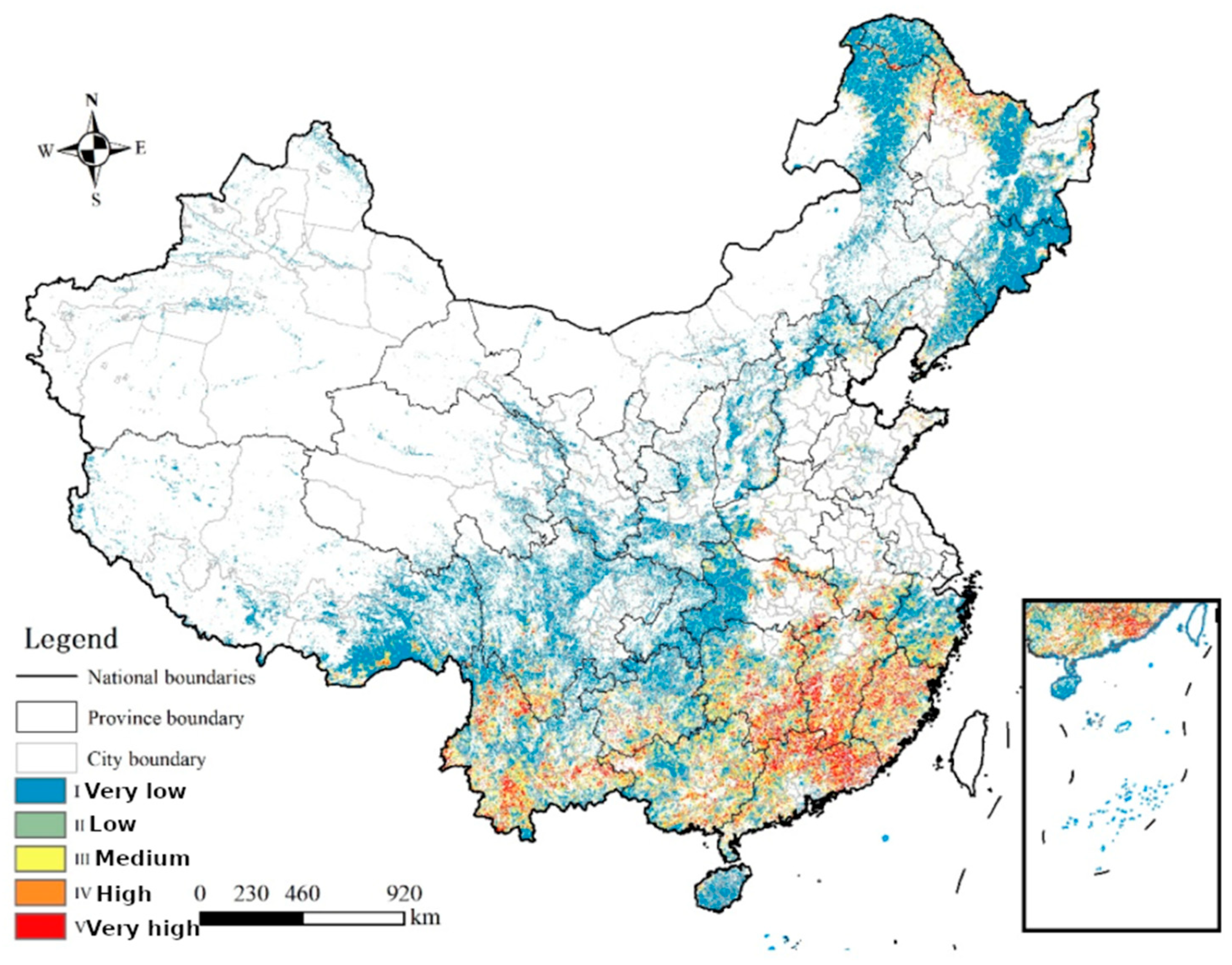
  2. Shao, Y.; Feng, Z.; Cao, M.; Wang, W.; Sun, L.; Yang, X.; Ma, T.; Guo, Z.; Fahad, S.; Liu, X.; et al. An Ensemble Model for Forest Fire Occurrence Mapping in China. Forests 2023, 14, 704. [Google Scholar] [CrossRef]
  3. Li, X.; Zhang, G.; Tan, S.; Yang, Z.; Wu, X. Forest Fire Smoke Detection Research Based on the Random Forest Algorithm and Sub-Pixel Mapping Method. Forests 2023, 14, 485. [Google Scholar] [CrossRef]
  4. Yan, Z.; Wang, L.; Qin, K.; Zhou, F.; Ouyang, J.; Wang, T.; Hou, X.; Bu, L. Unsupervised Domain Adaptation for Forest Fire Recognition Using Transferable Knowledge from Public Datasets. Forests 2023, 14, 52. [Google Scholar] [CrossRef]
  5. Li, A.; Zhao, Y.; Zheng, Z. Novel Recursive BiFPN Combining with Swin Transformer for Wildland Fire Smoke Detection. Forests 2022, 13, 2032. [Google Scholar] [CrossRef]
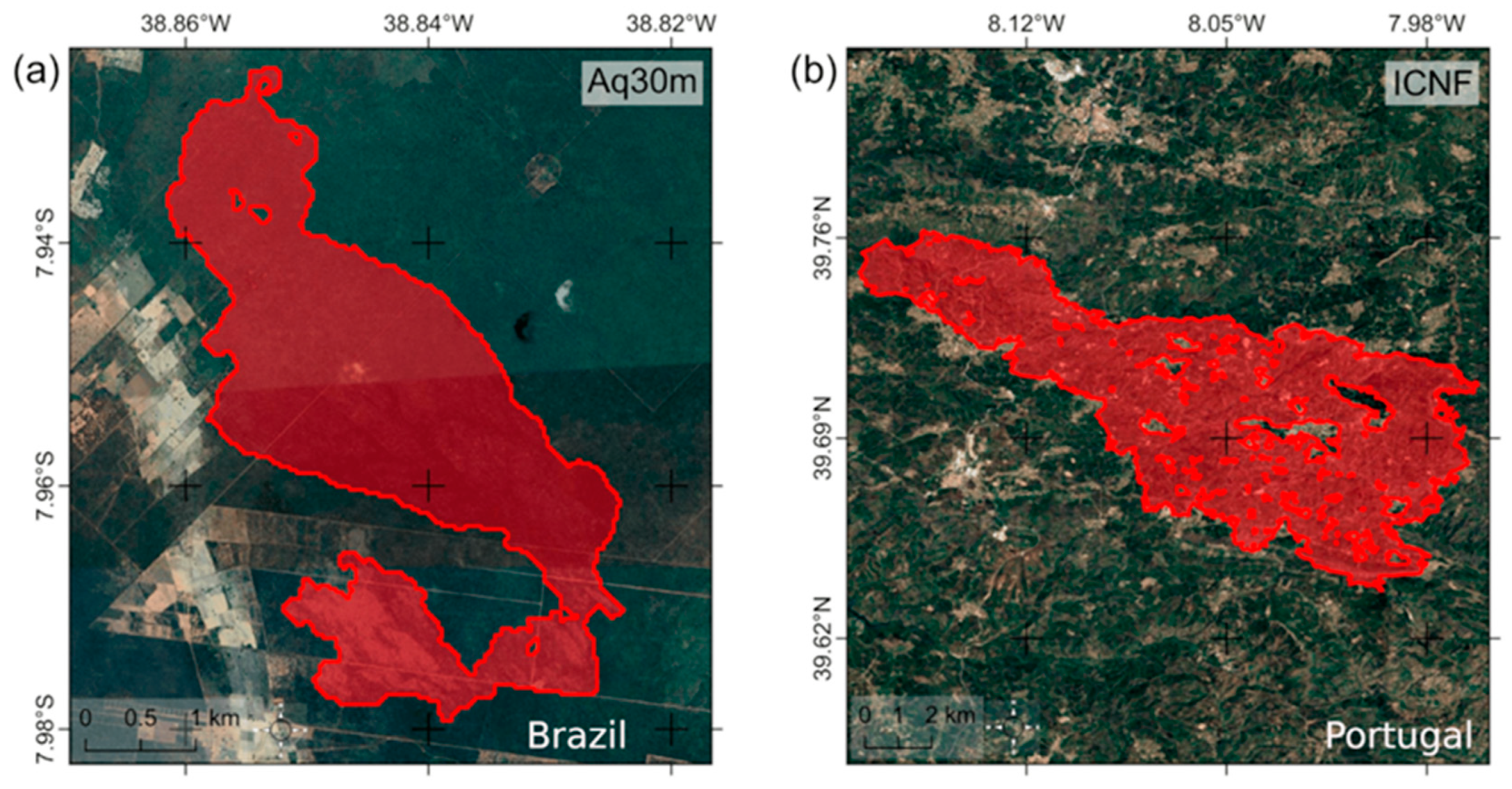
  6. Pacheco, A.d.P.; da Silva, J.A., Jr.; Ruiz-Armenteros, A.M.; Henriques, R.F.F.; de Oliveira Santos, I. Analysis of Spectral Separability for Detecting Burned Areas Using Landsat-8 OLI/TIRS Images under Different Biomes in Brazil and Portugal. Forests 2023, 14, 663. [Google Scholar] [CrossRef]
  7. Delgado, R.C.; Wanderley, H.S.; Pereira, M.G.; Almeida, A.Q.d.; Carvalho, D.C.d.; Lindemann, D.d.S.; Zonta, E.; Menezes, S.J.M.d.C.d.; Santos, G.L.d.; Santana, R.O.d.; et al. Assessment of a New Fire Risk Index for the Atlantic Forest, Brazil. Forests 2022, 13, 1844. [Google Scholar] [CrossRef]
  8. Yukimoto, S.; Kawai, H.; Koshiro, T.; Oshima, N.; Yoshida, K.; Urakawa, S.; Tsujino, H.; Deushi, M.; Tanaka, T.; Hosaka, M.; et al. The Meteorological Research Institute Earth System Model version 2.0, MRI-ESM2.0: Description and basic evaluation of the physical component. J. Meteorol. Soc. Jpn. 2019, 97, 931–965. [Google Scholar] [CrossRef]
  9. da Silva Junior, J.A.; Pacheco, A.d.P.; Ruiz-Armenteros, A.M.; Henriques, R.F.F. Evaluation of the Ability of SLSTR (Sentinel-3B) and MODIS (Terra) Images to Detect Burned Areas Using Spatial-Temporal Attributes and SVM Classification. Forests 2023, 14, 32. [Google Scholar] [CrossRef]
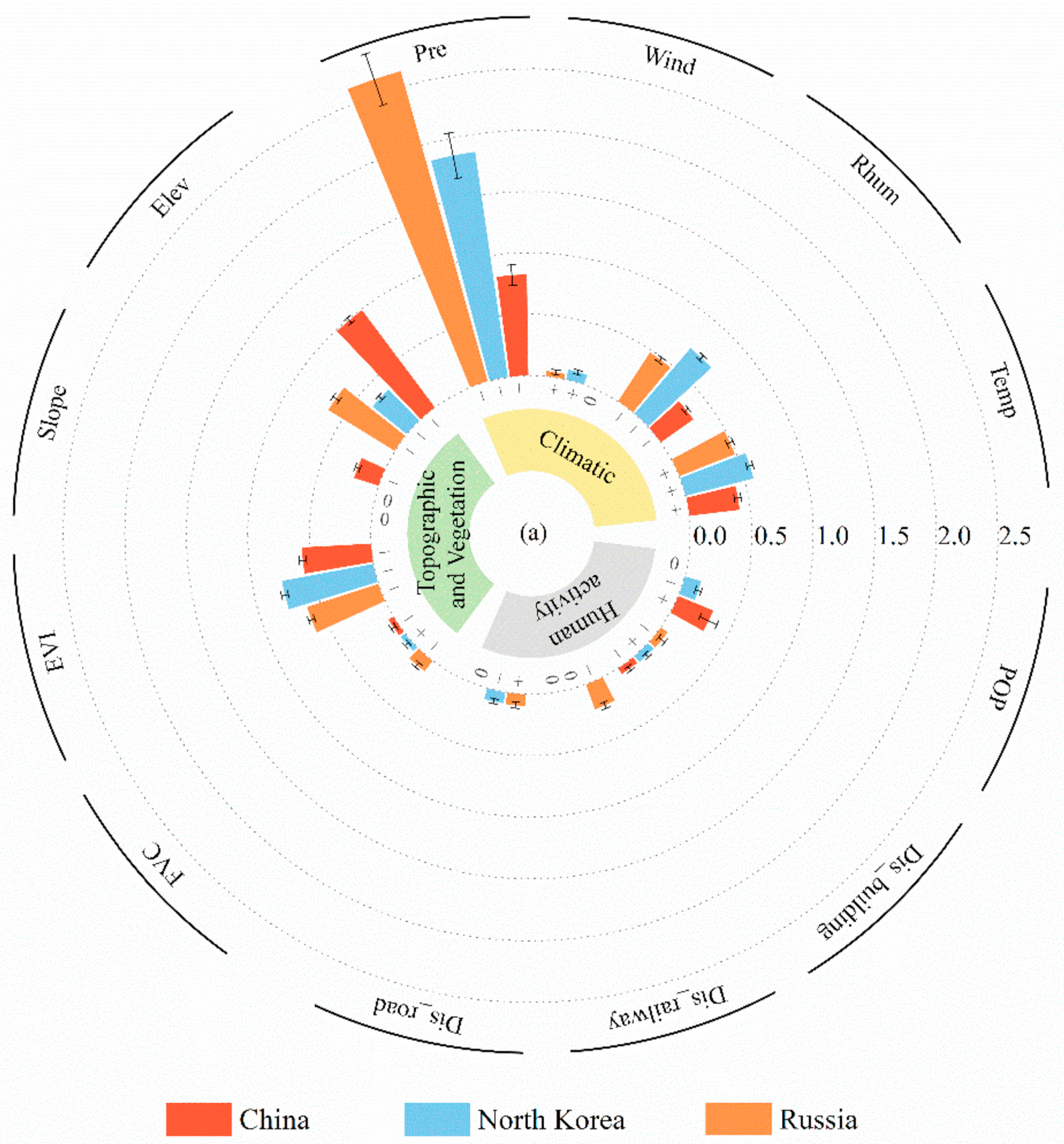
  10. Quan, D.; Quan, H.; Zhu, W.; Lin, Z.; Jin, R. A Comparative Study on the Drivers of Forest Fires in Different Countries in the Cross-Border Area between China, North Korea and Russia. Forests 2022, 13, 1939. [Google Scholar] [CrossRef]
Figure 1. Forest fire zoning in China. Adapted from Shao et al. [2].
Forests 15 00301 g001
Figure 2. Area burned using fire database for Brazil (a) with 30 m spatial resolution and geospatial fire database with 10 m spatial resolution for Portugal (b). Adapted from Pacheco et al. [6].
Forests 15 00301 g002
Figure 3. Partially standardized logistic regression coefficient size for each variable in the LR model adjustment process. Adapted from Quan et al. [10].
Forests 15 00301 g003
Disclaimer/Publisher’s Note: The statements, opinions and data contained in all publications are solely those of the individual author(s) and contributor(s) and not of MDPI and/or the editor(s). MDPI and/or the editor(s) disclaim responsibility for any injury to people or property resulting from any ideas, methods, instructions or products referred to in the content.

