Article

Source–Sink Structural Coupling Within Forest-Clustered Landscapes Drives Headstream Quality Dynamics in Mountainous Sub-Watersheds: A Case Study in Chongqing, China

1
College of Landscape Architecture and Art, Fujian Agriculture and Forestry University, Fuzhou 350002, China
2
College of Horticulture and Landscape Architecture, Southwest University, Chongqing 400716, China
3
State Key Laboratory of Urban and Regional Ecology, Research Center for Eco-Environment Sciences, Chinese Academy of Sciences, Beijing 100085, China
4
School of Architecture and Urban Planning, Chongqing Jiaotong University, Chongqing 400074, China
*
Author to whom correspondence should be addressed.
These authors contributed equally to this work.
Forests 2024, 15(11), 1979; https://doi.org/10.3390/f15111979
Submission received: 16 October 2024 / Revised: 5 November 2024 / Accepted: 7 November 2024 / Published: 8 November 2024
(This article belongs to the Section Forest Ecology and Management)

Abstract

:
Water environment quality is profoundly driven by a series of landscape characteristics. However, current knowledge is limited to the independent response of water quality to single landscape elements; this has led to poor knowledge of the potential role of structural coupling within landscapes in driving water quality changes, especially in those agroforestry-mixed mountainous watersheds with highly embedded forest-clustered landscapes and abundant headstreams. Given this fact, this study aims to evaluate whether and how the source–sink coupling structure of forest-clustered landscapes systematically drives headstream quality dynamics. We first systematically assessed the association pattern of source and sink structures within forest-clustered landscapes, and then innovatively proposed and constructed a functional framework of source–sink coupling structure of landscapes across 112 agroforestry-mixed mountainous sub-watersheds in Chongqing, China. On this basis, we further evaluated the driving pattern and predictive performance of the source–sink coupling structure of landscapes behind headstream quality dynamics. We report three findings: (1) headstream quality varied across agroforestry-mixed sub-watersheds, mapping out the source–sink structures and functions of landscapes; (2) there was significant functional coordination between source–sink structures of the forest-clustered landscapes, which significantly drove headstream quality dynamics; (3) the structural positioning and differences of the forest-clustered landscapes along the multivariate functional axes directly corresponded to and predicted headstream quality status. These findings together highlight a key logic that the response of water quality dynamics to landscapes is essentially that to the functional coupling between the source–sink structures of landscapes, rather than the simple combination of a single landscape contribution. This is the first study on the landscape–runoff association from the perspective of source–sink structural coupling, which helps to deepen understanding of the correlation mechanism between water dynamics and landscape systems, and provides a new functional dimension to the development of future landscape ecological management strategies from a local to a global scale.

1. Introduction

Water quality integrates critical regional ecological processes of landform, hydrology, and biology within a watershed [1], becoming the primary carrier of nutrient cycling in ecosystems and continuously affecting the aquatic ecosystem functioning from a local to a global scale [2,3,4]. A series of landscape characteristics and dynamics within a watershed are widely recognized as the best alternative indicator of water ecological status [5,6,7], becoming an essential way to improve the water environment quality of the watershed [8,9]. On this basis, the Source–Sink Landscape Theory further suggests that the effectiveness of the key ecological flow is controlled by the dynamic balance relationship of source–sink landscapes within a region, subsequently affecting the overall ecological processes and functions in stressed ecosystems significantly [10,11,12]. The source landscapes are defined as landscapes that promote the operation of specific ecological processes, while the sink landscapes inhibit ecological processes [13]. Generally, changes in each specific source or sink landscape may lead to changes in nutrient migration in aquatic ecosystems, water quality throughout the watershed, and the potential supply of multiple ecosystem services [7,14,15,16,17]. Consequently, an important theme consists of elucidating the dynamical water ecological processes from a landscape source–sink structure perspective to establish further associations with a series of water ecological protection strategies.
Although kinds of watershed ecological processes have been widely acknowledged as the result of non-linear joint actions of various landscape patterns [8,18], knowledge regarding water quality in almost all reports is limited to its independent responses to single landscape elements. However, there may be potential but essential coupling effects between the source and sink functions within landscapes from the perspective of ecosystem functionalism. Specifically, there may potentially be a functional synergy of landscape structures with the same attributes and the functional antagonism between landscape structures with different attributes in driving specific ecological processes [13]. In this context, a separate evaluation of a single source or sink element often fails to explain well the changes in water environment jointly controlled by multiple source–sink factors, as it may latently lose critical information concerning essential interactions within the covariant system of water quality and landscapes, e.g., reflecting the co-benefits and trade-offs typical of resource-constrained systems (e.g., the mountainous areas) [19]. This also directly confuses our understanding of the landscape driving processes behind regional water quality changes, leading to a significant over-/underestimation of a single source or sink landscape contribution and further restricting the effectiveness of the corresponding multi-scale water ecological protection strategies from local to global scales. However, there remains a blank regarding whether and how the system-level water quality dynamics substantially respond to trade-off patterns within landscape structures and functions.
In mountainous areas, the agroforestry-mixed watersheds dominated by various forest-clustered landscapes constitute the leading form of watershed. These forest-clustered landscapes are mainly dominated by forest land and are further interwoven with various landscape element patches under rural development and mountainous agricultural cultivation, forming a landscape complex system with high mosaic and spatial heterogeneity [13]. In addition, in these watersheds, the headstreams accumulatively account for the vast majority of the length of the river network [20,21] and are also the first receiving point and the first line of defense against pollutants, profoundly affecting the ecological functions of downstream river systems and even the entire watersheds [21,22,23]. However, because of the significant impacts of increasingly complex human disturbances [2,24], the deterioration of headstream quality has become one of the most severe ecological crises faced by most countries worldwide [3,4,25]. Due to the higher aquatic riverbank ratio, these headstreams are more susceptible to strong impacts from changes in surrounding landscape patterns [21]. More importantly, given the higher spatial heterogeneity of landscapes [26,27], the potential synergistic and antagonistic effects of source–sink functions within landscape systems and their underlying driving force behind headstream quality dynamics are expected to be greatly amplified in these agroforestry-mixed mountainous watersheds. However, the current attention given to these headstreams is still very limited [2,13,27]; its keynote still relies on one-sided correlation evaluation with a single landscape, potentially leading to substantial deviation in the effectiveness of landscape-management strategies and practices. Consequently, there is an urgent need to go beyond the limited knowledge on structure coupling within landscapes and their underlying systematic driving effects on headstream dynamics in these agroforestry-mixed mountainous watersheds, to maintain healthy headstream ecosystems and functioning under a range of possible future conditions.
Given this fact, this study aims to evaluate whether and how the source–sink coupling structure of the forest-clustered landscapes systematically drives headstream quality dynamics. Here, we proposed and empirically tested a new driving framework of the source–sink coupling structure of landscapes (SSCSL) for headstream dynamics from a functional perspective for the first time (Figure 1) and emphasized inquiry into the systematic response patterns of the headstream quality dynamics to the SSCSL along its source–sink functional gradients in the framework. Specifically, we hypothesize that (1) headstream quality dynamics correspond to variations in the source–sink pattern of landscapes across the agroforestry-mixed mountainous sites; (2) there are trade-off and coupling associations between the source and sink structures of landscapes, which further form systematic SSCSL and intensely drive the overall headstream quality dynamics; and (3) the differences and dynamics of headstream quality directly respond to the SSCSL, and are predictable for the functional differences and multi-dimensional structural positioning along the SSCSL gradient. These hypotheses, if they hold genuine and robust, will open up a crucial research dimension for evaluating regional landscape–runoff associations from the perspectives of structure and function coupling, rather than vaguely predicting the regional water ecological processes and developing sustainable management strategies through the over-/underestimation of a single landscape contribution.
Chongqing constitutes the core part of the Ridge and Valley Province of Chuandong, one of the three most prominent folded mountain ranges in the world, and is one of the most important mountainous cities in China. It holds the most typical agroforestry-mixed mountainous watersheds and the most representative forest-clustered landscape complexes in southern China. However, in recent years, the interaction and conflicts between headstream protection and landscape development in Chongqing have become increasingly severe, especially in those source sub-watersheds. Due to the lack of sustained attention and sustainable management towards the source region, the rivers have exhibited a water status reversal characterized by “good quality of downstream and poor quality of headstreams”, which greatly threatens the water ecological safety of local areas and even the entire Three Gorges Reservoir Area. Given this fact, Chongqing is an excellent and necessary case site for conducting this study. Specifically, we took 112 agroforestry-mixed sub-watersheds in Chongqing to test and validate the above hypotheses.

2. Study Area and Methods

2.1. Study Area and Site

Chongqing City (106°22′–106°37′ E, 29°26′–29°37′ N) is the most prominent mountain city in southwestern China, located in the upstream section of the Three Gorges Reservoir in the Yangtze River watershed (Figure 2). The area within its borders is characterized by high mountains and deep valleys, with numerous ravines. The mountainous region accounts for 76% of the total area, and the highest altitude difference reaches 2723.7 m. The climate there is the subtropical monsoon humid climate, with an average annual temperature of 16–18 °C, and the zonal vegetation is a subtropical evergreen broad-leaved forest with high coverage. Due to the diverse geological structures, complex rock types, and various parent materials in Chongqing, the soil types there are abundant. The most typical soil type is purplish soil, which is also the most representative high-fertility dryland soil in the Sichuan Basin, making it suitable for the development of agricultural production. Moreover, Chongqing has a relatively abundant annual average precipitation, mostly ranging from 1000 to 1350 mm and concentrated from May to September. Consequently, it holds a rich and developed water system network, with the 665 km main stream of the Yangtze River running from west to east across its entire region, and the water area per km2 ranks first in China.
The urban area of Chongqing is located in the western region, covering an area of 5473 km2 and accounting for 6.64% of the total area. Due to its location in the parallel mountain valley area of eastern Sichuan, the terrain there has significant undulations with a main elevation of 160–1000 m and a slope of 15–70°. On this basis, four north–south mountain ranges constitute the main mountainous framework of Chongqing’s urban area and intersect with two east–west rivers (the Jialing River and Yangtze River). As of the end of 2023, the permanent population of Chongqing urban area is 10.509 million. The economic construction there has basically formed a coexistence pattern of large agriculture, large industry, large transportation, and large circulation, making it the largest economic center city in southwestern China and the upper reaches of the Yangtze River.
Based on these natural environments and socio-economic backgrounds, Chongqing holds the most typical agroforestry-mixed mountainous watersheds and the most representative forest-clustered landscape complexes in southern China. However, in recent years, the interaction and conflicts between stream ecological protection and landscape development in mountain areas have become increasingly severe. This situation is particularly pervasive in the suburban sub-watersheds of the four mountain ranges, which greatly threatens the water ecological safety of local areas and even the entire Three Gorges Reservoir Area. Given this fact, the suburban agroforestry-mixed mountainous sub-watersheds in the four mountain ranges of Chongqing urban area were selected to conduct this study. Specifically, the eastern, southern, western, and northern suburban sections of four mountain ranges were employed in the study (Figure 2), which enables the full coverage of different mountain ranges, locations, and sizes of mountainous watersheds to reduce the possible potential impacts from their differentiation.

2.2. Division of the Sub-Watersheds

First, we used a regional Digital Elevation Model for the spatial and hydrological analysis modules of ArcGIS 10.5 and collected 10 typical agroforestry-mixed mountainous watersheds with representative forest-clustered landscape complexes in the four study sites (Table S1). Next, 4–20 agroforestry-mixed mountainous sub-watersheds and their ranges within each watershed were further extracted by setting the primary stream as the basic unit in the spatial and hydrological analysis modules of ArcGIS 10.5 (Table S1). Ultimately, a total of 112 agroforestry-mixed mountainous sub-watersheds with their ranges were obtained.
To avoid the potential impacts of the differentiation in mountain ranges, locations, and sizes on the landscape composition of different watersheds, an analysis of similarity (ANOSIM) and a Spearman’s correlation analysis were performed. Results showed no significant difference between different locations and mountain ranges across the divided watersheds (ANOSIM R = 0.23, p = 0.132). Also, the watershed area had no significant impact on mountainous forest-clustered landscape composition (p > 0.05). These analyses showed the validity of using the selected 112 sub-watersheds extracted from 4 study sites and 10 watersheds as parallel samples (Table S2).
Stream flow and boundaries of all extracted sub-watersheds were corrected based on field investigation to avoid possible local terrain changes at specific locations (e.g., landslides and certain agricultural activities) to improve the analysis accuracy.

2.3. Headstream Sample Collection and Headstream Quality Evaluation

Headstream samples with three replicates at the stream outlets of each sub-watershed (Figure S1) were collected monthly for one consecutive year from September 2018 to August 2019. The sampling time was around mid-month to keep a corresponding time interval between each month, and it was sunny for over three days. Before sampling, we first rinsed the self-made water sampler and the 250 mL polyethylene bottle (with the sample number) with the headstream from the sample point several times to ensure the purity of the water sample. Subsequently, samples were taken from the headstream at the outlet of each sub-watershed. Due to the shallow water level of headstreams in the mountainous sub-watersheds (with a depth of less than 0.5 m), the headstream samples below the water surface at the center of the sampling section were collected with a 0.5 L self-made water sampler. Each water intake point of the stream was sampled three times, with a 3 min interval between each sampling. All collected samples were stored in the rinsed polythene bottles and transported to the laboratory on the same day, where they were further processed for the determination of water quality indicators. Due to the measurement requirements of different pollutants, the headstream samples were divided into three 100 mL polyethylene bottles at a ratio of 1:1:1. Then, the three sub-samples were pretreated with the original water sample, acidified with hydrochloric acid, and acidified with sulfuric acid, respectively. After gently shaking, the corresponding pretreatment methods were labeled on the bottle. Subsequently, a set of headstream samples were randomly selected one by one for chemical measurements. Until measurement, samples were stored in a cold room at 4 °C.
Among various water quality indicators characterizing water ecological status, the five most commonly used pollutant indicators in agroforestry-mixed areas, i.e., total nitrogen (TN), total phosphorus (TP), dissolved oxygen (DO), ammonium nitrogen (NH4+-N), and chemical oxygen demand (COD), were adopted first. Moreover, as the mountainous watersheds are often connected to downstream protected drinking water sources, another five pollutant indicators related to drinking water, i.e., nitrate nitrogen (NO3-N), sulfate (calculated as SO42−), chlorides (calculated as Cl), lead (Pb), and chromium (Cr), were therefore further employed. The determination of all indicators followed the standard methods specified in Surface Water Environmental Quality Standards [28].
The overall headstream quality and underlying pollution risks were evaluated by the concentration of the ten single pollutants in annual water samples and the corresponding Comprehensive Pollution Index (CPI). The former referred to the above national standards, which classified surface water into five water environmental categories (e.g., drinking water and agricultural water) based on the specific concentration standard of each pollutant (NEPB, 2002) (Table S4). Subsequently, the headstream CPI was calculated based on the above water quality grades (Equation (1)) to reflect the comprehensive pollution risks of multiple pollutants in surface water (Table S5).
C P I x = 1 n i = 1 n C i S x i
where CPIx denotes the comprehensive pollution index under the water quality grades x; n is the number of pollutant indicators; Ci denotes the measured concentration of pollutant i (mg/L); Sxi is the standard concentration limit of pollutant i (mg/L) under the water quality grades x.

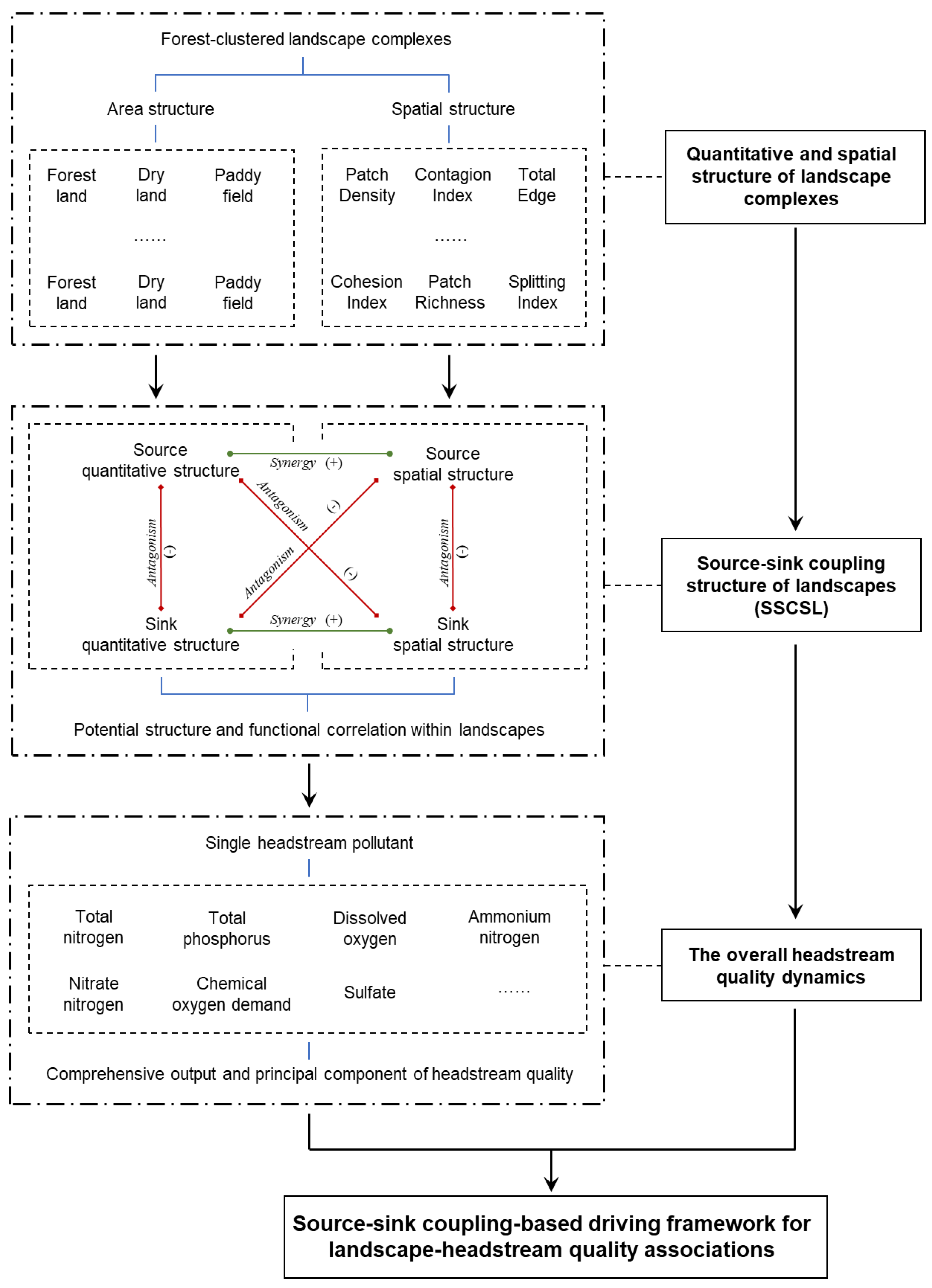
2.4. Landscape Element Classification and Landscape Structure Extraction

According to the basic framework of watershed ecological processes, the water quality at the outlet of each headstream was spatially matched to the overall structure and pattern of all landscape complexes within its sub-watershed area (Figure S1).
Referring to the Current Land Use Classification [29], the overall forest-clustered landscapes were divided into nine types of landscape elements, i.e., forest land (FL, including natural or semi-natural forests and bamboo forests), construction land (CL), dry land (DL), paddy field (PF), traffic land (TL), shrub and grass (SG), garden land (GL), water area (WA), and bare land (BL). We manually drew the boundaries of all patches for each landscape element in ArcGIS 10.5 based on the high-definition satellite images (resolution of 1 m, period from September 2018 to August 2019) and field investigation to avoid possible errors in the complete interpretation of remote sensing. Then, the area and quantitative structure of various landscape elements in different sub-watersheds were calculated. Based on the field investigations on the spatial distribution of mountainous forest-clustered landscapes, four landscape spatial structure metrics, i.e., the Area and Edge Metrics, Shape Metrics, Aggregation Metrics, and Diversity Metrics, and the contained 26 specific indexes were calculated in Fragstats 4.2 to reflect the spatial structure characteristics of mountainous forest-clustered landscape complexes comprehensively (Table S3).
Based on the Source–Sink Landscape Theory, the source landscape structures in this study were defined as those landscape structures that significantly promoted headstream pollutant export, while the sink landscape structures were defined as those that significantly reduced pollutant concentration. Particularly, based on our preliminary investigation on agroforestry-mixed mountainous watersheds, we consider that headstream quality dynamics is more closely related to the spatial structure of source–sink landscapes than that of the overall landscapes. Therefore, the source–sink landscape patterns proposed in this study referred to the spatial structures and the corresponding indexes of the source–sink landscape elements extracted above.

2.5. Statistical Analyses

To evaluate the overall headstream quality in the agroforestry-mixed mountainous sub-watersheds and its cross-site variability, a principal component analysis (PCA) was performed. Also, a Pearson’s or Spearman’s correlation analysis was generally used to (1) test the accompanying relationship of headstream pollutant output, (2) analyze the effects of the quantitative structure of landscapes on headstream quality dynamics, and (3) identify the source and sink quantitative structures of landscape elements, after testing the normality with the Shapiro–Wilk test. The quantitative structures with significant positive effects on headstream quality changes were identified as the source landscape structures, while those with significant adverse effects were defined as the sink landscape structures. Any landscape element with no significance was excluded in subsequent analysis. Then, the spatial structures of the extracted source–sink landscapes were calculated, and the source and sink spatial structures of landscapes were obtained by repeating the above analyses. The non-metric multi-dimensional scaling (NMDS) was applied to obtain the distribution patterns of the similarity of the quantitative structure of source–sink landscapes and their source–sink spatial structures across different sites. Also, the Kruskal–Wallis test was used to assess the differences in headstream pollutant output and the CPI between sites dominated by source and sink landscape patterns.
Subsequently, several PCAs were further employed to quantify the multivariate pattern of variations for (1) headstream quality based on responding pollutant output, (2) the source–sink quantitative and spatial structures of landscapes, and (3) their combination (i.e., the SSCSL), respectively. By comparing the PCA axes scores through Pearson’s or Spearman’s correlation analysis, depending on the data distribution, we assessed (1) the functional axes associations between quantitative and spatial structures of the source–sink landscapes, (2) the structure associations between the above two and the SSCSL, and (3) correlations between principal component (PC) axis of the responding headstream quality and the SSCSL gradient.
After MIN-MAX standardization for the data, the squared Euclidean distance was used to systematically cluster the sub-watersheds with different headstream pollutant outputs using the Ward.D method. Then, the Kruskal–Wallis test and the ANOSIM were further performed to test the differences for each single index and the overall source–sink landscapes across different clustering groups.
To assess the correlations between the PCA axes of headstream quality and the SSCSL, we also performed regression after log10(x + 1) transformation for the CPI values to correct for residual deviations from normality. Also, the interactions between the source landscape structure and the sink landscape structure on water quality dynamics were tested.
Dissimilarities in headstream quality and the SSCSL for each pair of two sub-watersheds were calculated. Mahalanobis distance was used as the standardized and integrative distance to determine the differences between the two samples and the positioning in a multi-dimensional source–sink landscape space. Different source–sink landscape indexes were normalized before analysis, as they were measured in different units. To evaluate the correlations between the dissimilarities in headstream quality and the SSCSL across sub-watersheds, we performed regression after log10(x + 1) transformation for the pairwise Bray–Curtis dissimilarity data (calculated through Equation (2)).
B C D i j = k = 1 n X i k X j k k = 1 n X i k + X j k
where the BCDij denotes the Bray–Curtis dissimilarity between samples i and j; n is the number of headstream pollutant and source–sink structure indicators; Xik and Xjk denote the normalized values of indicator k in samples i and j, respectively.
All statistical analyses were performed in R 4.0.0.

3. Results

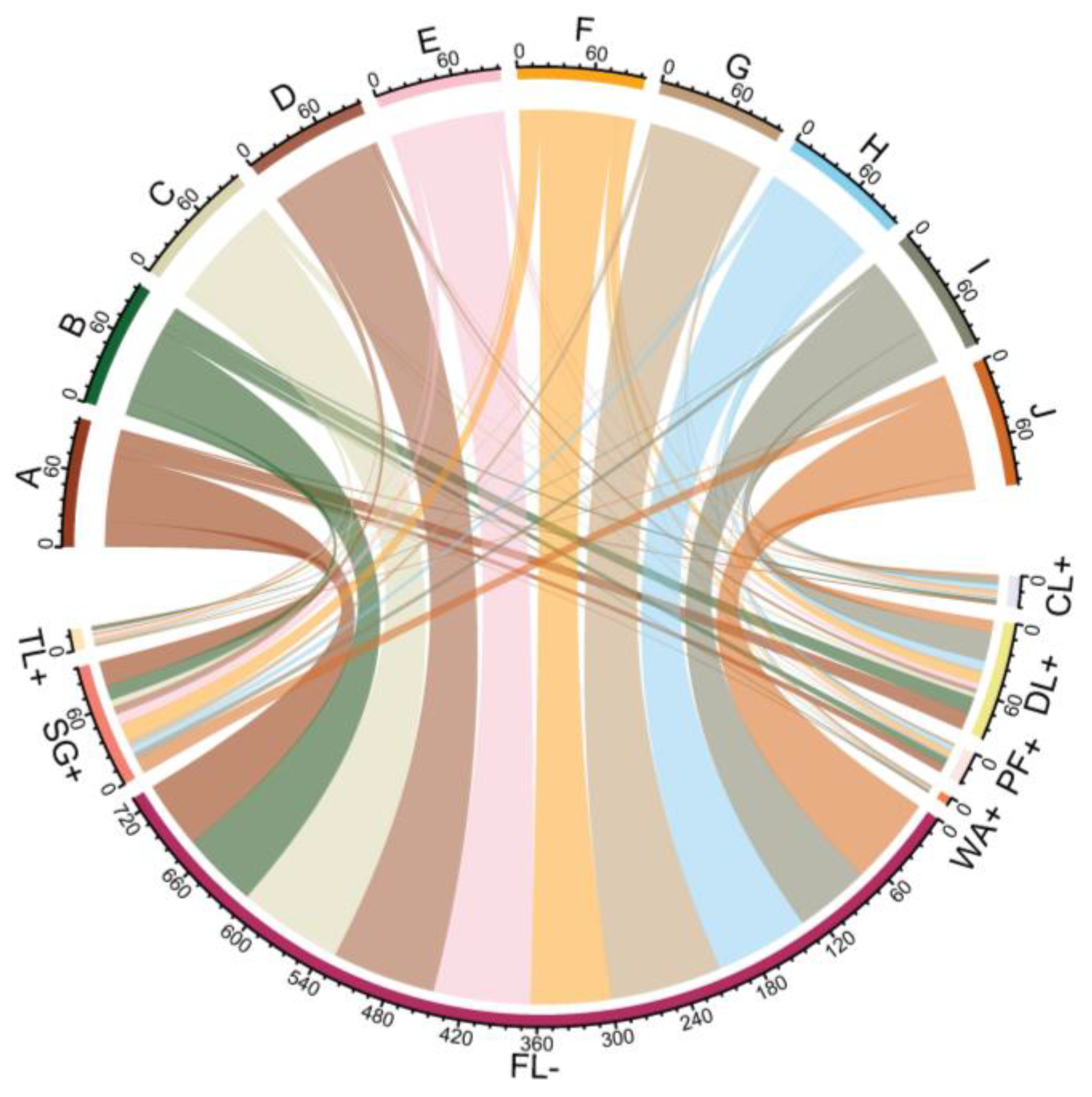
3.1. Headstream Quality Dynamics and the Underlying Source and Sink Structures of Landscapes

Most of the pollutant indicators in headstreams varied significantly across the agroforestry-mixed mountainous sub-watersheds (Figures S2 and S3) and showed accompanying output correlation (Table S6). Generally, the headstream quality in the agroforestry-mixed mountainous sub-watersheds belonged to the standard of IV-V, while some exceeded the V standard, mainly under TN and COD pressure (Figure S2 and Table S4).
The headstream-oriented sink landscape element in the agroforestry-mixed mountainous sub-watersheds was mainly the FL, displaying a cross-site quantitative structure of 72.35 ± 1.56%, while the source landscape elements contained the CL, DL, PF, TL, WA, and SG, accounting for 26.94 ± 1.55% (Figure S4 and Figure 3). All extracted quantitative structures of the source–sink landscapes jointly explained 56.8% of the structure changes captured by the first two PCA axes, among which the FL contributed the most to the cross-site difference (Figure S5). Also, spatial indexes related to the area, edge, and aggregation of landscapes constituted the most important source–sink spatial structure with a variation of 62.0% (Figures S6 and S7). Notably, the quantitative and spatial source–sink structures of landscapes strongly correlated on PC axes, especially for their first PC axes (PC1) (r = −0.80, p < 0.001) (Table S7). Moreover, the variation of CPI was spatially covariate with the overall source and sink structures of the forest-clustered landscapes (Figure 4).

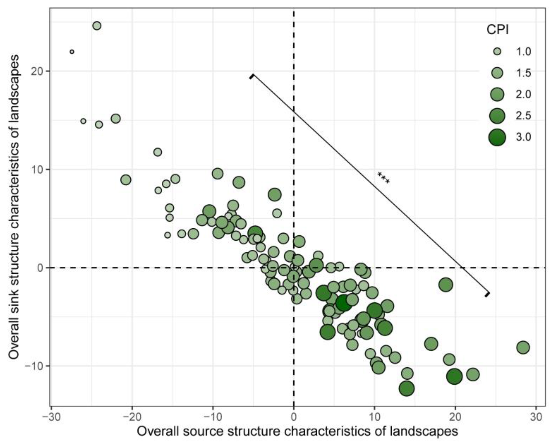
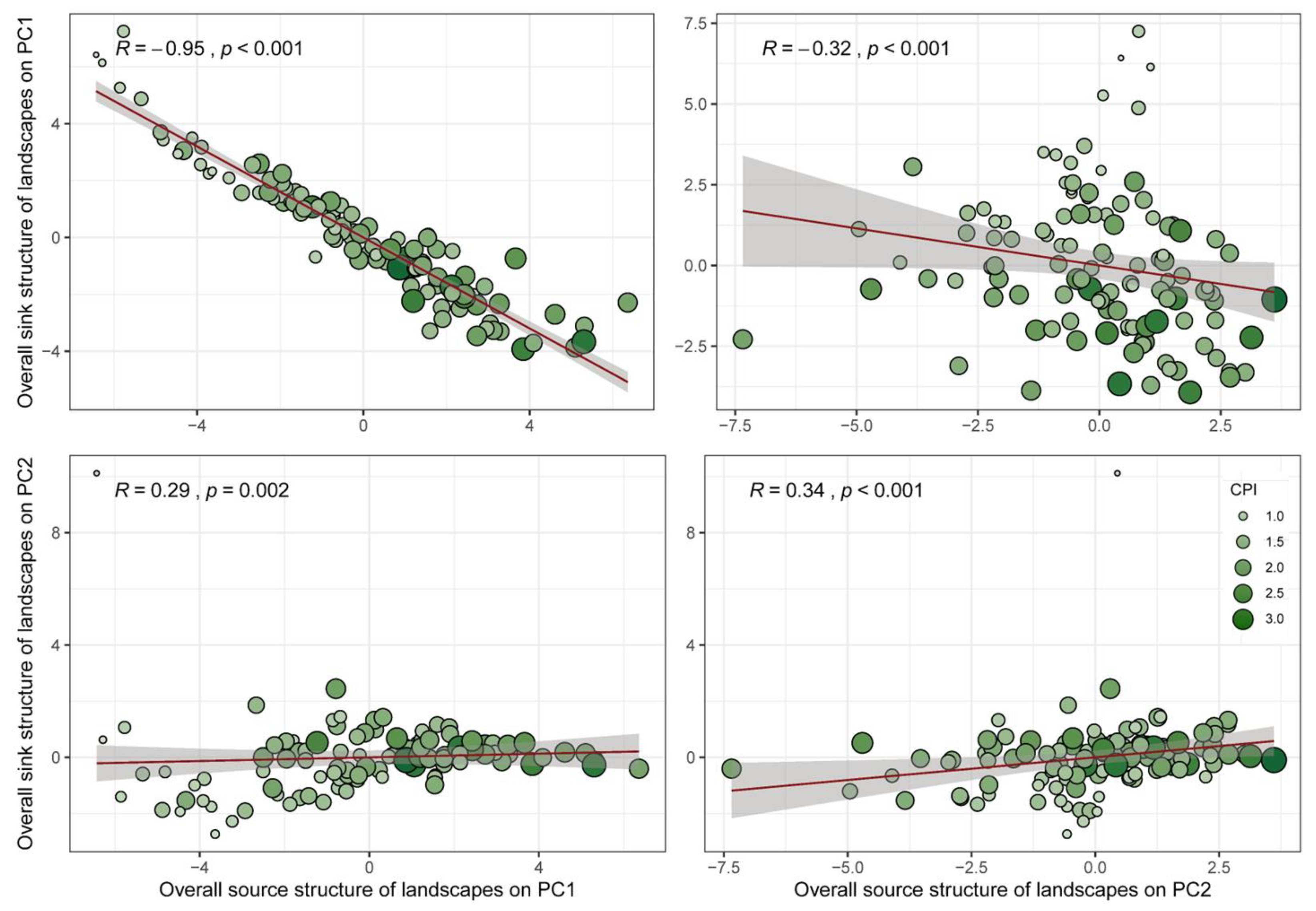
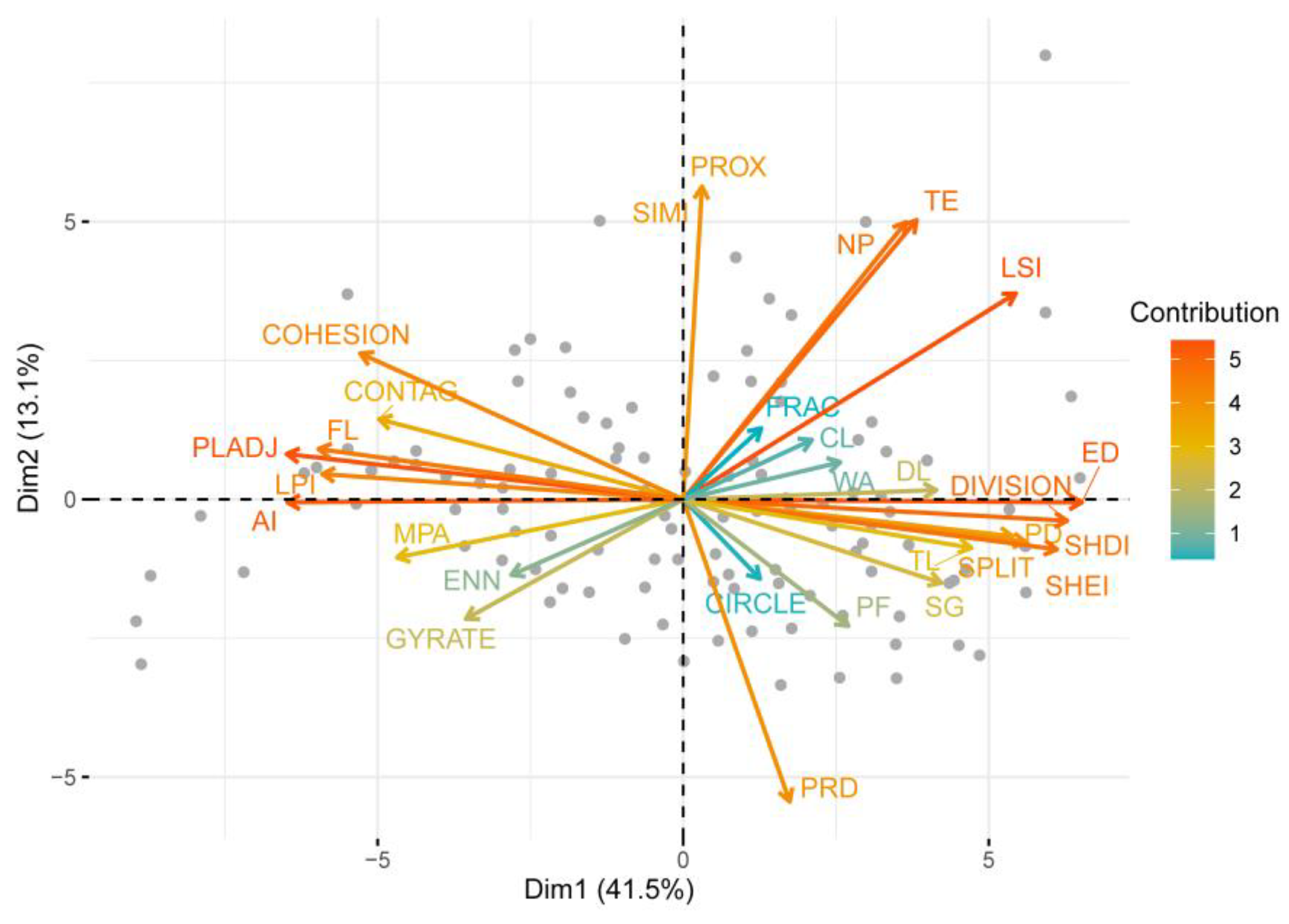
3.2. Headstream Quality-Based SSCSL That Reflect Source–Sink Function Trade-Offs

The negative correlations between the PC axes of source and sink landscape structures were significant, especially on their PC1 axes (R = −0.95, p < 0.001) (Figure 5), indicating the source and sink structures of forest-clustered landscapes were highly coordinated and had unequivocal trade-off relationships. Furthermore, through their combination, the SSCSL was well integrated for all the source–sink structures, where a synergistic relationship of sink function was found between quantitative and spatial structures of landscapes dominated by PLADJ, AI, FL, LPI CONTAG, and COHESION; and also a source synergy existed between the dominated ED, DIVISION, SHDI, SHEI, SPLIT, TL, and DL (Figure 6 and Table S8). However, the two structural groups were functionally antagonistic within the landscapes (Figure 6). Specifically, the FL, as well as the guiding indicators related to the dominance, aggregation, and connectivity of the source–sink spatial patches, especially the AI, PLADJ, LPI, and COHESIOIN, constituted the negative end of the continuous functional axes of the PC1, representing the investment allocation of landscapes in the sink structure and function was mainly based on the forest-dominated spatial configuration investment (Figure 6). In contrast, the quantitative structure of landscape elements represented by TL, DL, and SG, and the edge, separation, and diversity, especially the ED, DIVISION, SHDI, and SHEI, formed the opposing end of PC1, representing the investment allocation of landscapes in the source structure and function was mainly for the investment in the patch diversity and dispersion of human-interference elements (Figure 6).

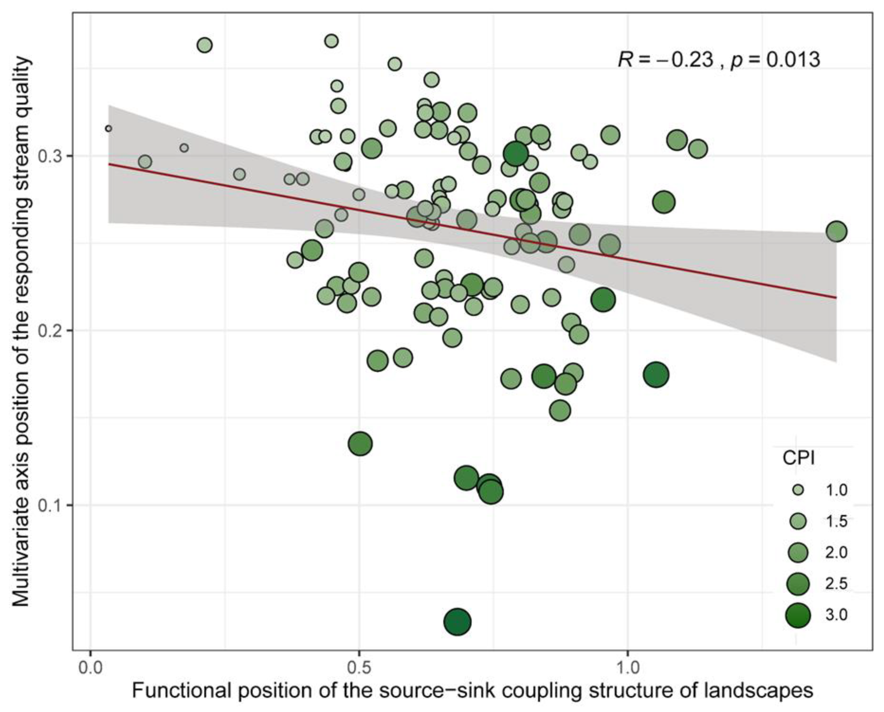
3.3. Response Pattern of Headstream Quality Dynamics to the SSCSL

Under different clusters of headstream quality, there were significant intergroup differences in the overall and specific source–sink quantitative and spatial structures of the forest-clustered landscapes (ANOSIM R = 0.15 and p = 0.001, Table S9). The overall differences in headstream quality changes were jointly driven by several source–sink quantitative and spatial structures of the forest-clustered landscapes (Figures S4 and S6, Table S10). Moreover, the multivariate functional axes of the SSCSL had significant predictive value for the comprehensive pollution dynamics of headstreams, mainly along PC1 (R = 0.57 and p < 0.001, Figure 7). In general, the more substantial the investment of landscapes in the source elements represented by the TL and DL and the concerning edge complexity and diversity structures, as well as the weaker the investment in the sink elements (e.g., FL) and the concerning spatial configuration functions, the more significant the promotion of the output of headstream quality pollutants (Figure 6 and Figure 7 and Table S10). Furthermore, the characteristics of headstream quality directly corresponded to the functional spatial localization of the SSCSL (Figure 8).

3.4. Headstream Quality Feedback on Coupling Structure Differences Along the SSCSL Gradient

Generally, the responses of headstream quality dynamics to source and sink landscape structures were asynchronous (Figure S8), which implied that the investment differences of the forest-clustered landscapes in the source–sink coupling structure might directly lead to an increase in systematic feedback differences in headstream quality. On this basis, we found that the difference between the forest-clustered landscapes in the source and sink functional gradients directly reflected specific headstream quality status (R = 0.19, p = 0.043) (Figure S9). Furthermore, in all 6216 paired samples, significant and robust positive relationships were found between the dissimilarities in headstream quality dynamics and landscape structures along the functional gradient of SSCSL across all pairs (R = 0.76, p < 0.001) (Figure 9), indicating the increase in differences along the SSCSL was often accompanied by a significant increase in headstream quality differences.

4. Discussion

In light of the significant differences in the source and sink functions within the landscape systems, an in-depth knowledge on whether and how the source–sink trade-off and coupling structure of landscapes systematically drives water quality dynamics evidently matters for an advanced revelation of the key roles that human–environment coupling systems play in response to the changing global environments [24,27]. It is also considered a necessary condition for developing management strategies to improve or prevent further decline in regional ecological value [2,30], especially for the mountainous agroforestry areas with high spatial heterogeneity and abundant headstreams. Here, we have demonstrated the systematic correlations between the source–sink coupling structures within the forest-clustered landscape systems, as well as the formed robust SSCSL, and headstream quality dynamics from a functional perspective. All the findings highlight our core viewpoint, i.e., the response of water quality dynamics to landscapes is essentially that to the functional coupling between the source–sink structures of landscapes, rather than the simple combination of a single landscape contribution. Below, we discuss the findings in more detail.

4.1. Source and Sink Structures of the Forest-Clustered Landscapes

Research has shown that source–sink dynamics are not only constrained by their diffusion from source to sink but also control spatial flow and the ecological impacts through the composition of source–sink patches [10]. In this study, landscape elements related to human interference, e.g., the CL, DL, and PF, were found to be the source landscape elements, while the FL held prominent quantitative advantages across the agroforestry-mixed sites and showed significant sink effects (Figure 3 and Figure S4). This is roughly similar to the findings of Lin et al. [13] and supports the idea that the dominant forest areas in mountainous regions are key to providing a wide range of ecosystem services [31,32]. In comparison to FL, the distribution of landscape elements that require active management was usually more restricted by the mountainous environment, resulting in more differentiated spatial distribution [2]. However, the WA exhibited significant source attributes (Figure 3), contrary to the sink attributes reported in studies such as Yu et al. [8]. Although the difference was clear, there have also been reports on water bodies as a source of surface runoff pollutants. For example, Caruso et al. [33] found that the TP input in lakes during winter was less than its total output, indicating that lake sediments might release a certain amount of TP. Moreover, in field investigations, we found that many planar WAs in inland agroforestry-mixed mountainous areas were used for aquaculture, which is consistent with the findings of investigations on headstreams in other watersheds in China [13,34]. Due to a lack of management or excessive aquaculture, the decomposition of accumulated excrement makes the WA a source of pollutant output [13]. Furthermore, the SG, it should be noted, generally played an important role in reducing runoff pollutants [8,35], yet it showed a certain source effect in this study (Figure 3). Actually, southwest China is experiencing large-scale farmland abandonment [13], which is particularly common in the studied agroforestry-mixed mountainous sub-watersheds. Subsequently, the abandoned farmland undergoes secondary succession and is transformed into SG. Therefore, a possible reason lies in abundant nutrients accumulating in the soil of abandoned farmland due to long-term agricultural activities, together with the death and decomposition of annual herbs in the early stage of succession, making the SG become the source in agroforestry-mixed sub-watersheds. This result strongly supports a challenging viewpoint that short-term natural succession or grain for green may still be a source rather than a sink [36].

4.2. Coupling and Trade-Off Pattern of the Source–Sink Structures of Landscapes

Although it is clear we can define source or sink as the impacts of a single landscape on ecological processes in the context of dynamic landscapes, we believe that this concept may not necessarily be transformed in spatial systems from an integrated functional perspective. This standpoint receives lateral support from existing research; for example, two different patch configurations of source and sink landscapes, although they may have the same environmental characteristics, tend to respond differently to the fragmentation or destruction of spatial flow [10]; furthermore, the asymmetry in patch size may also affect the magnitude of nutrient spatial flow, even though the key transition between positive and negative effects may not be altered, as larger source patches have stronger impacts clearly [10]. Therefore, the interpretation of source–sink function by a single landscape is not entirely satisfactory regarding actual ecological processes, as it may lead to insufficient evaluations of system function and quality. Our results further support this phenomenon. Specifically, we found firmly coordinated system-level negative relationships between the source and sink landscape structures, integrating their quantitative and spatial structures, from a functional perspective (Figure 5). This is consistent with the previous view that there may be potential correlations between landscape structures [9,13], and further expands their system-level associations. Certainly, it means there are trade-offs between the variation in source and sink structures and functions, which generally cannot be eliminated under limited resource constraints [19], e.g., in such agroforestry-mixed mountainous areas. Additionally, although the only studies that mentioned the correlation between landscape structures have focused on the evaluation of the relationships between individual landscape structures, our findings were also in keeping with these scattered research results. For example, previous studies have reported a potential correlation between forest coverage and landscape fragmentation [37], and have also found that their changes did not always develop in the same direction [38]; and in our SSCLS framework, although the correlations between the quantitative structure of the FL and fragmentation-related spatial structures such as PD, ED, and DIVISION were clear (p < 0.001), they did indeed constitute the opposite ends of the functional axis in the overall coupling structure (Figure 6). On this basis, the latest global-scale research also provides supporting viewpoints for our research findings that if only the fragmentation or coverage was considered, the credibility of large-scale estimation of forest landscape pattern dynamics would decrease [14,15,39]. Consequently, there was an urgent need to effectively integrate and analyze the changes in forest coverage and fragmentation patterns to provide information for forest-management decisions [14,15,39]. This also implies that, in this coordinated and strongly coupled state of source–sink landscape structures, conclusions drawn from previous large-scale studies on the ecological impacts of the overall landscapes should be carefully considered, as they may mask the variability within the landscape functional systems and become a manifestation of the variability of landscape-driven ecological processes.
Therefore, in the context of the source–sink trade-offs, it is crucial to reveal the source–sink structures and functional patterns of landscape complexes from the perspectives of functionalism, especially in the agroforestry-mixed mountainous areas, which are often considered complex places for landscape and ecology research [26,27]. As we predicted, there was a specific SSCSL, accounting for explanations of 54.6% of the source–sink structural variation of the cross-regional forest-clustered landscapes (Figure 6). Overall, the landscape indexes that reflected the investment strategy of the source–sink function (e.g., TL, DL, ED, SHDI, DIVISION) were basically consistent with the PC1 of SSCSL, while the load of certain indexes, such as CIRCLE and FRAC, on SSCSL was relatively low, reflecting the increasing tendency from landscape-development strategies to conservative strategies (Figure 6). These characteristics reflect the balance of the forest-clustered landscape investment in source and sink functions. For example, a high FL ratio with high aggregation and connectivity (high AI and PLADJ values) is closely related to the preservation of landscape naturalness, i.e., the investment in sink structure and sink function propels the formation of the ecological structure of the forest-clustered landscapes. On the other hand, high DL and TL ratios, as well as high ED and DIVISION, which refer to the investment of landscapes in source structure and function, encourage the formation of fragmentation of the forest-clustered landscapes. This result embraces and supports the scattered associations previously reported between single landscape structures. For example, Wear et al. [37] reported that as forest coverage decreased, the landscape contagion also significantly decreased, while the landscape fragmentation increased; and in our findings, the FL also showed a significant synergistic association with CONTAG, while antagonizing with fragmentation-related structures such as ED and DIVISION (Figure 6). These results all demonstrate that landscape systems potentially rely on the spatial positioning and its equilibrium properties of source–sink functions and form the basis for the adaptability and persistence of complex self-organizing systems of regional ecosystems through the hierarchical organization, coordination, complementarity, and integration of the quantitative and spatial structures of various landscape components.

4.3. Driving Force of the SSCSL Behind Headstream Quality Dynamics

Whether the dynamics of landscape systems are coordinated with regional ecological processes is crucial, since it indicates whether the landscape complexes may accelerate or slow down nutrient turnover in regional natural systems through the overall-level landscape–ecology associations [14,24], but the corresponding complex comprehensive regulation and response mechanism still need further exploration [2,13]. Similar to previous research [6,34], we found that the landscape quantitative structure related to human activities increased the output of headstream pollutants such as N and P, while the landscape elements related to natural preservation (mainly FL) embraced the opposite (Figure S4). Furthermore, in terms of landscape spatial structure, consistent with previous findings [14,34,40], it was manifested as higher landscape fragmentation, poorer spatial connectivity, higher diversity, and poorer headstream quality (Figure S6). Given that the relationship between a single landscape element and water quality is sufficient, we avoid excessive repetitive discussions here. However, there are still notably significant differences in the impacts of specific landscapes across different studies with prodigious spans in explaining water quality changes from 17% to 70.2% [41]. Although this is partially attributed to regional heterogeneity, we also believe that another important reason lies in the lack of consideration for the internal source–sink conflicts and coupling correlations within landscape systems, since changes in river quality are the result of the comprehensive participation of various complex ecological processes within multiple landscape systems [24,32,42]. In this case, a single landscape element may not be sufficient to explain the ecological processes controlled by multiple factors together [13], as the intense conflict between the source–sink functional systems within the landscapes may further trigger biases of external ecological driving associations and substantial conflicts in simulation results, especially for those agroforestry-mixed mountainous watersheds with high mosaic and spatial heterogeneity. For example, in the simulation of the water quality-oriented forest thresholds in agroforestry areas, Clement et al. [43] indicated that rivers had better water quality when the forest coverage exceeded 47%, while Liu et al. [44] found that when the forest coverage threshold under conventional agricultural management was below 57%–61%, sediment output would significantly increase. Also, this threshold variation may have significant differences in some cases even within the same region [45,46]. Further, research has found that there was a certain degree of covariation between landscape distribution driven by human factors and the natural environment [47,48], which might directly or indirectly affect river ecosystems and water quality. On this basis, the clear trade-offs we found proved the existence of such covariation between landscapes. This has also received lateral but strong support from some research findings that, for example, farmland could alter nearshore soil nutrients by regulating runoff nutrients, thereby affecting plant growth, composition, and diversity of nearshore vegetation, and further interfering with vegetation community structure and boundary expansion [49,50]. Moreover, the contact degree between agriculture and forests was capable of affecting the sink effect of forests on nutrients [43]. Therefore, a crucial but often overlooked debate lies in the issue of how much covariance occurs between different landscapes. This also potentially becomes a possible explanation for some research findings that deviate from general patterns, e.g., Caldwell et al. [51] reported that the pollutant-export rate from some forest-dominated catchments was higher than that from developed or agricultural catchments across regions. Therefore, a deep understanding of the systematic contribution and driving mechanisms of the SSCSL, which reveals internal functional coupling and trade-offs, to water quality dynamics is apparently essential, but it still remains unknown. As the multivariate axes of continuous functional variation reflected landscape source and sink structures, the SSCSL captured most structural changes and their trade-off correlations in landscape complexes (Figure 6). Consequently, our study provides a supportive explanation for the aforementioned colossal span of correlations between water quality and landscapes across research. Specifically, as predicted, we found strong evidence that the dynamic changes in headstream quality were systematically driven by the multivariate characteristic axes of the SSCSL (Figure 7 and Figure 8). Overall, a more substantial investment of the forest-clustered landscapes in the functional axis of source elements and their edge complexity and diversity, as well as a weaker investment in the functional axis of sink elements and their advantageous patches, spatial aggregation, and connectivity, will promote the output of headstream pollutants significantly. This supports previous scattered findings based on single landscape structures in agroforestry-mixed watersheds. For example, Gardner et al. [52] reported that the larger the PD and LSI of farmland and orchards, the higher the concentrations of TN, TP, COD, and chlorophyll-a in runoff, while Ding et al. [34] indicated that the AI of forests exhibited significant negative correlation with NO3-N.
Moreover, highly specialized and imbalanced investment strategies in ecosystems may lead to potential differences in the consequences of ecological processes [53,54]. Surprisingly, we found that the multivariate status of headstream quality in the agroforestry-mixed mountainous watersheds could be directly reflected by the functional positioning of specific landscapes in the SSCSL (Figure 8). Furthermore, the dynamic changes and differences in headstream quality could be explained by the source–sink investment differences along the SSCSL (Figure S9 and Figure 9). This further suggests the strong system-level functional coordination that potentially exists within the structures of source–sink landscapes, rather than the independent driving patterns of single landscape structures for headstream quality changes, which supports the complex nonlinear interaction of landscapes [8,18]. The source and sink dynamics of landscapes, when it comes to fragmented landscape complexes (e.g., in such agroforestry-mixed mountainous areas), are more complementarily aggregated, and usually generate proliferative ecological benefits that go beyond the simple superposition of individual functions of each landscape component. For example, it has been reported that increasing the forestland area alone could reduce N and P pollutants, whereas sediment pollutants reduced when the grassland area and forestland increased [55]. Here, our proposed potential coupling and interaction of source–sink landscape structures offer a direct explanation for this phenomenon. Also, the trade-off correlations of source–sink structures of landscapes may partially explain the decoupling of water quality dynamics and landscapes found in some studies. For example, in the absence of consideration for landscape structure coupling, Dymek et al. [56] reported the absence of an unequivocal negative impact of 6 main land-cover types on 15 river quality parameters in 34 catchments of Poland; also, Yu et al. [57] found the TN concentration in the Naoli River wetlands was decoupled with four area indexes and eight shape indexes, but its removal was restricted by the synergistic effect of the landscape area and shape characteristics. Apparently, this also means that the coupling and trade-off system of landscape source–sink structures and functions is vital for defining and amplifying the systematic connections of site-level landscape ecology research, not only for the forest-clustered landscape complexes in the agroforestry-mixed watersheds in this study, to connect broader and even cross-scale ecological management practices.

4.4. Enlightenment for Future Landscape Sustainable Management in the Agroforestry Watersheds

Targeting the universally damaged aquatic ecosystems, many countries have invested significant resources and funds in recent years to restore surface water quality throughout the entire watershed [58]. Although this has shown initial effectiveness in the middle and lower reaches of rivers, source water quality at the agroforestry-mixed upstream has not been efficaciously controlled due to the limitations of many restoration measures imposed by the unique mountainous geographical environment and highly heterogeneous landscape composition [13]. Undoubtedly, the premise for designing the best water ecological management practices lies in accurately assessing the potential driving factors and response processes of the deteriorating headstream quality dynamics [59]. However, as mentioned, landscape structures are often considered separately for aquatic ecosystem assessment in most studies [34,60], with the proposal of the single landscape thresholds for guiding practices. The results of this discrete association assessment and the oriented changes in landscape thresholds may have significant differences or uncertainties in specific situations, even within the same area [45,46]. Furthermore, parallel to the existing knowledge context that focuses on correlation assessment between a single landscape and water quality, current ecological management strategies favor simulation optimization for a single landscape element, especially for those agroforestry-mixed areas. However, previous studies have laterally shown that the one-sided landscape optimization that lacks consideration of the trade-offs and coordination of structure and function within landscape systems may also exacerbate ecological deterioration. For example, in responding to the commonly found sink effect of forest land, many strategies are dedicated to improving river water quality by increasing forest area [13]. However, studies have shown that blind afforestation actually leads to regional water quality degradation (e.g., through the extensive use of various fertilizers or chemicals) [61] and water resource damage (e.g., a decrease in surface water flow and groundwater reserves, and an increase in watershed evapotranspiration) [55]. Furthermore, although the forest area appears to have increased, the current widespread patchwork greening mode may exacerbate landscape fragmentation, thereby reducing the efficiency of ecological flows. Therefore, biased emphasis on the management and planning of a single landscape may directly lead to a substantial deviation in the effectiveness of landscape strategies and practices, which also potentially becomes one of the direct explanations for the worse headstream quality in the upstream of Chongqing with highly heterogeneous mountainous landscapes.
Based on the findings of this study, we proposed a critical core viewpoint that the response of headstream quality to landscape dynamics is essentially the response to the functional coupling and trade-off results within landscape systems. The changes in their coupling and interaction association may also directly induce changes in the core source or sink attributes of the related landscape. For example, research has shown that the polders could be either N and P sources or sinks, following different polder–river interactions [59]. This also means that if consideration is lacking for the structural coupling and functional interaction within landscapes, misjudgment might arise when further identifying the key objects and areas in landscape-management practices. Consequently, we strongly encourage the intra-system coupling of source–sink functions and structures within the landscapes as a priority in research of landscape ecological processes and future management practices, rather than simply relying on the indiscriminate evaluations of the independent responses of ecosystem dynamics to the single landscape structures or their scattered superposition. Actually, targeting the widely distributed agroforestry watersheds, many scholars have been devoted to exploring the prominent ecological impacts of changes in associations between agriculture land and forest land in recent years. For example, Li et al. [62] found that the landscape structure combining forests and agricultural land has a stronger impact on river water pollution than a single forest or agricultural land in the Yuqiao watershed in China; Clement et al. [43] also found that the degree of contact between agriculture and forests also affected the sink effect of forests on nutrients. Moreover, a study focusing on the mountainous watersheds in Chongqing showed that the structural ratio of agriculture land to forest land (AL/FL) significantly impacted river quality, the contribution of which to water quality even exceeded the single agriculture land or forest land [13]. Moreover, AL/FL stably dominated the key landscape thresholds that disrupted water quality dynamics, and the landscape ecological security pattern under different water quality objectives could be established through different AL/FL regulations [13]. But in a specific sense, whether for the integration of agriculture and forests, the contact between agriculture and forests, or the coordination of AL/FL, the essence is precisely the regulation of the source–sink structural coupling association within landscapes highlighted in this study. This further supports the significance of the source–sink coupling structure and corresponding functional trade-offs of landscapes in achieving comprehensive control and sustainable management of water environment quality in the agroforestry mountainous watersheds. Given that the actual landscapes often exist in a complex form of multiple element combinations, future work of ecological strategy makers is worth moving the gaze of ecological management mode from a single landscape simulation to optimization planning with the objective of a balanced association of source–sink landscape structures, to tackle a range of potential ecological challenges in the future more effectively, especially in the context of increasingly complex global change.

5. Conclusions

Given the complexity of landscape ecological processes, a prerequisite for a better understanding of landscape–runoff associations lies in further elucidating their systematic response to the coupled driving effects of the dual source–sink structure trade-offs within landscapes, especially for the highly fragmented forest-clustered landscapes. In this research, we proposed a novel landscape structure pattern of the SSCSL that integrated the coupling associations between source–sink functions and found that (1) the cross-site variation of headstream quality in the agroforestry-mixed mountainous watersheds was the result of the synergy, antagonism, and comprehensive trade-offs of the source–sink structures within landscapes; (2) its dynamics were directly driven by the systematic SSCSL coupled with the trade-offs between source–sink structures; (3) the overall headstream quality status was effectively predicted through the multi-dimensional positioning and investment differences of the source–sink structure within a given landscape along the SSCSL route. Based on these findings, we highlight a core underlying logic that the response of headstream quality to dynamic landscape systems is essentially the response to the structural trade-offs and functional coupling within landscapes, rather than to the independent contribution of individual landscapes. Consequently, we strongly encourage the effective integration of the source–sink coupling structures of landscapes and their dual ecological driving forces in future landscape ecology research and landscape-management practices, rather than just treating landscapes as a simple combination of different independent structures. This is not only conducive to revealing the crucial correlation mechanism between ecological dynamics and landscape systems at various levels in depth, but also has essential implications for future strategy developments for landscape ecological security from a local to a global scale.
Given the complexity and specificity of mountainous agroforestry-mixed environments [26,27], an essential addition for the trajectory in further studies should be extended to plain agroforestry-mixed areas with lower spatial mosaic and simpler landscape composition. In this case, the weight and pattern of water quality response to the SSCSL are expected to shift with changes in geographical environmental gradients; for example, the covariation between water pollutant output and the balance between synergistic and antagonistic effects of source–sink landscapes would become more direct.

Supplementary Materials

The following supporting information can be downloaded at: https://www.mdpi.com/article/10.3390/f15111979/s1, Figure S1. Schematic diagram of sampling point distribution of the headstream. Figure S2. Dynamics of pollutant output in mountainous headstream and the comprehensive pollutant index in the agroforestry-mixed sub-watersheds. Figure S3. PCA ordinations of the pollutant output in headstreams. Figure S4. Correlation heatmap of the quantitative structure of landscapes and stream pollutant output. Figure S5. NMDS ordinations (left, dimension = 2) and PCA ordinations (right) of the quantitative structure of source-sink landscapes. Figure S6. Correlation heatmap of the spatial structure of landscapes and stream pollutant output. Figure S7. NMDS ordinations (left, dimension = 2) and PCA ordinations (right) of the source-sink spatial structure of the source-sink landscapes. Figure S8. Spearman’s correlations between the PC axes of the source and sink structure of landscapes and the comprehensive pollutant index of the responding stream quality. Figure S9. Pearson correlations of the investment differences (Euclidean distance) between source and sink structures of landscapes and the multivariate position of responding headstream quality in the agroforestry-mixed sub-watersheds. Table S1. Basic overview of the agroforestry-mixed mountainous sub-watersheds. Table S2. Spearman’s correlations (r values with p values) between watershed area and the landscape composition. Table S3. Types and formulas of spatial structure indexes of landscapes. Table S4. Stream quality grade and corresponding pollutant output standards according to Surface Water Environmental Quality Standards (mg/L). Table S5. Different ranges of the comprehensive pollution index (CPI value) and the corresponding water quality condition. Table S6. Spearman’s correlations (r values) between different pollutant outputs in mountainous headstreams. Table S7. Spearman’s correlations (r values with p significance values in parentheses) of the PC axes between the source-sink quantitative and spatial structures of landscapes. Table S8. Spearman’s correlations (r values with p significance values in parentheses) of the source-sink coupling structure of landscapes (SSCSL) and the quantitative and spatial structures of the source-sink landscapes in the agroforestry-mixed mountainous sub-watersheds. Table S9. Significance of the differences in specific indicators of source-sink landscape structures (Kruskal-Wallis test, Chi-square with p significance values in parentheses) and the overall source-sink landscape structures (ANOSIM, R values with p significance values) across different steam quality clustering groups (Ward.D method). Table S10. Spearman’s correlations (r values with p significance values in parentheses) of the specific indicators of source-sink landscape structures and the PC axes of corresponding stream quality.

Author Contributions

L.L. (Li Lin): Conceptualization, Methodology, Software, Validation, Formal analysis, Investigation, Data Curation, Writing, Visualization, Project administration; K.Q.: Software, Investigation, Data Curation; C.Y.: Methodology, Formal analysis, Visualization; W.R.: Software, Validation, Formal analysis; H.Z.: Investigation, Resources; C.S.: Validation, Formal analysis; X.L.: Investigation, Resources; F.L.: Software, Validation; L.L. (Lingyun Liao): Software, Formal analysis; S.L.: Supervision, Project administration; M.L.: Resources, Supervision, Project administration; H.W.: Resources, Supervision, Project administration, Funding acquisition. All authors have read and agreed to the published version of the manuscript.

Funding

This research was funded by the Department of Higher Education Students, Ministry of Education (Grant No. 20230113487), the Education and Research Project for Middle and Young Teachers of the Department of Education of Fujian Province (Grant No. JAT220058), Fujian Province Innovation Strategy Research Science and Technology Program Project (Grant No. 2024R007), the Humanities and Social Sciences Research Youth Foundation, Ministry of Education, China (Grant No. 20YJC760079), the Humanities and Social Science Research Project of Chongqing, Municipal Education Commission (Grant No. 22SKGH171), the Fujian Provincial Natural Science Foundation (Grant No. 2022J01613), and Fujian Agriculture and Forestry University Special Fund for Scientific and Technological Innovation (Social Sciences) (Grant No. KCX22F60A).

Data Availability Statement

The data presented in this study are available on request from the corresponding author. Due to the confidentiality period of some data, it will not be made public.

Acknowledgments

Many thanks are given to Xiangwu Cai for optimizing some of the graphic presentations. The authors are grateful to Ecological Landscape team members of SWU and Blue Health team members of FAFU. We also acknowledge many who joined this research on one or more occasions for their contributions to fieldwork or measurements.

Conflicts of Interest

The authors declare no conflict of interest.

References

  1. Keeler, B.L.; Polasky, S.; Brauman, K.A.; Johnson, K.A.; Finlay, J.C.; O’Neill, A.; Kovacs, K.; Dalzell, B. Linking water quality and well-being for improved assessment and valuation of ecosystem services. Proc. Natl. Acad. Sci. USA 2012, 109, 18619–18624. [Google Scholar] [CrossRef] [PubMed]
  2. Encalada, A.C.; Flecker, A.S.; Poff, N.L.; Suarez, E.; Herrera-R, G.A.; Rios-Touma, B.; Jumani, S.; Larson, E.I.; Anderson, E.P. A global perspective on tropical montane rivers. Science 2019, 365, 1124–1129. [Google Scholar] [CrossRef] [PubMed]
  3. Woodward, G.; Gessner, M.O.; Giller, P.S.; Gulis, V.; Hladyz, S.; Lecerf, A.; Malmqvist, B.; McKie, B.G.; Tiegs, S.D.; Cariss, H.; et al. Continental-scale effects of nutrient pollution on stream ecosystem functioning. Science 2012, 336, 1438–1440. [Google Scholar] [CrossRef] [PubMed]
  4. Yu, C.; Huang, X.; Chen, H.; Godfray, H.C.J.; Wright, J.S.; Hall, J.W.; Gong, P.; Ni, S.; Qiao, S.; Huang, G.; et al. Managing nitrogen to restore water quality in China. Nature 2019, 567, 516–520. [Google Scholar] [CrossRef] [PubMed]
  5. Yu, S.; Xu, Z.; Wu, W.; Zuo, D. Effect of land use types on stream water quality under seasonal variation and topographic characteristics in the Wei River basin, China. Ecol. Indic. 2016, 60, 202–212. [Google Scholar] [CrossRef]
  6. Shi, P.; Zhang, Y.; Li, Z.; Li, P.; Xu, G. Influence of land use and land cover patterns on seasonal water quality at multi-spatial scales. Catena 2017, 151, 182–190. [Google Scholar] [CrossRef]
  7. Li, Y.; Mi, W.; Ji, L.; He, Q.; Yang, P.; Xie, S.; Bi, Y. Urbanization and agriculture intensification jointly enlarge the spatial inequality of river water quality. Sci. Total Environ. 2023, 878, 162559. [Google Scholar] [CrossRef]
  8. Yu, W.; Zhang, J.; Liu, L.; Li, Y.; Li, X. A source-sink landscape approach to mitigation of agricultural non-point source pollution: Validation and application. Environ. Pollut. 2022, 314, 120287. [Google Scholar] [CrossRef]
  9. Zhang, Y.; Li, Z.; Wang, T.; Wang, P.; Xu, R.; Wang, J. Effects of source-sink landscape proximity on the spatial-temporal water quality from the perspective of cost distance in an agricultural watershed. J. Hydrol. 2024, 628, 130569. [Google Scholar] [CrossRef]
  10. Gravel, D.; Guichard, F.; Loreau, M.; Mouquet, N. Source and sink dynamics in meta-ecosystems. Ecology 2010, 91, 2172–2184. [Google Scholar] [CrossRef]
  11. Li, W.; Cao, Q.; Lang, K.; Wu, J. Linking potential heat source and sink to urban heat island: Heterogeneous effects of landscape pattern on land surface temperature. Sci. Total Environ. 2017, 586, 457–465. [Google Scholar] [CrossRef] [PubMed]
  12. Sun, R.; Xie, W.; Chen, L. A landscape connectivity model to quantify contributions of heat sources and sinks in urban regions. Landsc. Urban Plan. 2018, 178, 43–50. [Google Scholar] [CrossRef]
  13. Lin, L.; Li, M.; Chen, H.; Lai, X.; Zhu, H.; Wang, H. Integrating landscape planning and stream quality management in mountainous watersheds: A targeted ecological planning approach for the characteristic landscapes. Ecol. Indic. 2020, 117, 106557. [Google Scholar] [CrossRef]
  14. Cohen, M.J.; Creed, I.F.; Alexander, L.; Basu, N.B.; Calhoun, A.J.K.; Craft, C.; D’Amico, E.; DeKeyser, E.; Fowler, L.; Golden, H.E.; et al. Do geographically isolated wetlands influence landscape functions? Proc. Natl. Acad. Sci. USA 2016, 113, 1978–1986. [Google Scholar] [CrossRef]
  15. Taubert, F.; Fischer, R.; Groeneveld, J.; Lehmann, S.; Mueller, M.S.; Roedig, E.; Wiegand, T.; Huth, A. Global patterns of tropical forest fragmentation. Nature 2018, 554, 519–522. [Google Scholar] [CrossRef]
  16. Foley, J.A.; DeFries, R.; Asner, G.P.; Barford, C.; Bonan, G.; Carpenter, S.R.; Chapin, F.S.; Coe, M.T.; Daily, G.C.; Gibbs, H.K.; et al. Global consequences of land use. Science 2005, 309, 570–574. [Google Scholar] [CrossRef]
  17. Yang, S.; Zhao, W.; Liu, Y.; Wang, S.; Wang, J.; Zhai, R. Influence of land use change on the ecosystem service trade-offs in the ecological restoration area: Dynamics and scenarios in the Yanhe watershed, China. Sci. Total Environ. 2018, 644, 556–566. [Google Scholar] [CrossRef] [PubMed]
  18. Kozak, J.; Gimmi, U.; Houet, T.; Bolliger, J. Current practices and challenges for modelling past and future land use and land cover changes in mountainous regions. Reg. Environ. Chang. 2017, 17, 2187–2191. [Google Scholar] [CrossRef]
  19. Gao, L.; Bryan, B.A. Finding pathways to national-scale land-sector sustainability. Nature 2017, 544, 217–222. [Google Scholar] [CrossRef]
  20. Meyer, J.L.; Strayer, D.L.; Wallace, J.B.; Eggert, S.L.; Helfman, G.S.; Leonard, N.E. The contribution of headwater streams to biodiversity in river networks. J. Am. Water Resour. Assoc. 2007, 43, 86–103. [Google Scholar] [CrossRef]
  21. Wohl, E. The significance of small streams. Front. Earth Sci. 2017, 11, 447–456. [Google Scholar] [CrossRef]
  22. Gomi, T.; Sidle, R.C.; Richardson, J.S. Understanding processes and downstream linkages of headwater systems. Bioscience 2002, 52, 905–916. [Google Scholar] [CrossRef]
  23. Rodrigues, V.; Estrany, J.; Ranzini, M.; de Cicco, V.; Tarjuelo Martin-Benito, J.M.; Hedo, J.; Lucas-Borja, M.E. Effects of land use and seasonality on stream water quality in a small tropical catchment: The headwater of Corrego Agua Limpa, Sao Paulo (Brazil). Sci. Total Environ. 2018, 622, 1553–1561. [Google Scholar] [CrossRef] [PubMed]
  24. Cheng, F.Y.; Van Meter, K.J.; Byrnes, D.K.; Basu, N.B. Maximizing US nitrate removal through wetland protection and restoration. Nature 2020, 588, 625–630. [Google Scholar] [CrossRef] [PubMed]
  25. Cooley, S.W.; Ryan, J.C.; Smith, L.C. Human alteration of global surface water storage variability. Nature 2021, 591, 78–81. [Google Scholar] [CrossRef]
  26. Gibon, A.; Sheeren, D.; Monteil, C.; Ladet, S.; Balent, G. Modelling and simulating change in reforesting mountain landscapes using a social-ecological framework. Landsc. Ecol. 2010, 25, 267–285. [Google Scholar] [CrossRef]
  27. Peters, M.K.; Hemp, A.; Appelhans, T.; Becker, J.N.; Behler, C.; Classen, A.; Detsch, F.; Ensslin, A.; Ferger, S.W.; Frederiksen, S.B.; et al. Climate-land-use interactions shape tropical mountain biodiversity and ecosystem functions. Nature 2019, 568, 88–92. [Google Scholar] [CrossRef]
  28. GB 3838-2002; Environmental Quality Standards for Surface Water. Ministry of Ecology and Environment of the People’s Republic of China: Beijing, China, 2002. (In Chinese)
  29. GB/T 21010-2017; Current Land Use Classification. National Technical Committee for Standardization of Natural Resources and Territory Spatial Planning of the People’s Republic of China: Beijing, China, 2017. (In Chinese)
  30. Mottet, A.; Ladet, S.; Coque, N.; Gibon, A. Agricultural land-use change and its drivers in mountain landscapes: A case study in the Pyrenees. Agric. Ecosyst. Environ. 2006, 114, 296–310. [Google Scholar] [CrossRef]
  31. Alkama, R.; Cescatti, A. Biophysical climate impacts of recent changes in global forest cover. Science 2016, 351, 600–604. [Google Scholar] [CrossRef]
  32. Bryan, B.A.; Gao, L.; Ye, Y.; Sun, X.; Connor, J.D.; Crossman, N.D.; Stafford-Smith, M.; Wu, J.; He, C.; Yu, D.; et al. China’s response to a national land-system sustainability emergency. Nature 2018, 559, 193–204. [Google Scholar] [CrossRef]
  33. Caruso, B.S.; O’Sullivan, A.D.; Faulkner, S.; Sherratt, M.; Clucas, R. Agricultural diffuse nutrient pollution transport in a mountain wetland complex. Water Air Soil Pollut. 2013, 224, 1695. [Google Scholar] [CrossRef]
  34. Ding, J.; Jiang, Y.; Liu, Q.; Hou, Z.; Liao, J.; Fu, L.; Peng, Q. Influences of the land use pattern on water quality in low-order streams of the Dongjiang River basin, China: A multi-scale analysis. Sci. Total Environ. 2016, 551, 205–216. [Google Scholar] [CrossRef] [PubMed]
  35. Teixeira, Z.; Teixeira, H.; Marques, J.C. Systematic processes of land use/land cover change to identify relevant driving forces: Implications on water quality. Sci. Total Environ. 2014, 470, 1320–1335. [Google Scholar] [CrossRef] [PubMed]
  36. Wang, Y.; Shen, J.; Yan, W.; Chen, C. Effects of landscape development intensity on river water quality in urbanized areas. Sustainability 2019, 11, 7120. [Google Scholar] [CrossRef]
  37. Wear, D.N.; Turner, M.G.; Naiman, R.J. Land cover along an urban-rural gradient: Implications for water quality. Ecol. Appl. 1998, 8, 619–630. [Google Scholar] [CrossRef]
  38. Liu, J.; Coomes, D.A.; Gibson, L.; Hu, G.; Liu, J.; Luo, Y.; Wu, C.; Yu, M. Forest fragmentation in China and its effect on biodiversity. Biol. Rev. 2019, 94, 1636–1657. [Google Scholar] [CrossRef]
  39. Ma, J.; Li, J.; Wu, W.; Liu, J. Global forest fragmentation change from 2000 to 2020. Nat. Commun. 2023, 14, 3752. [Google Scholar] [CrossRef]
  40. Ai, L.; Shi, Z.H.; Yin, W.; Huang, X. Spatial and seasonal patterns in stream water contamination across mountainous watersheds: Linkage with landscape characteristics. J. Hydrol. 2015, 523, 398–408. [Google Scholar] [CrossRef]
  41. Xu, Q.Y.; Guo, S.F.; Zhai, L.M.; Wang, C.Y.; Yin, Y.H.; Liu, H.B. Guiding the landscape patterns evolution is the key to mitigating river water quality degradation. Sci. Total Environ. 2023, 901, 165869. [Google Scholar] [CrossRef]
  42. Mwaijengo, G.N.; Msigwa, A.; Njau, K.N.; Brendonck, L.; Vanschoenwinkel, B. Where does land use matter most? Contrasting land use effects on river quality at different spatial scales. Sci. Total Environ. 2020, 715, 134825. [Google Scholar] [CrossRef]
  43. Clement, F.; Ruiz, J.; Rodriguez, M.A.; Blais, D.; Campeau, S. Landscape diversity and forest edge density regulate stream water quality in agricultural catchments. Ecol. Indic. 2017, 72, 627–639. [Google Scholar] [CrossRef]
  44. Liu, H.; Yi, Y.; Blagodatsky, S.; Cadisch, G. Impact of forest cover and conservation agriculture on sediment export: A case study in a montane reserve, south-western China. Sci. Total Environ. 2020, 702, 134802. [Google Scholar] [CrossRef]
  45. Fitzpatrick, F.A.; Scudder, B.C.; Lenz, B.N.; Sullivan, D.J. Effects of multi-scale environmental characteristics on agricultural stream biota in eastern Wisconsin. J. Am. Water Resour. Assoc. 2001, 37, 1489–1507. [Google Scholar] [CrossRef]
  46. Wang, L.Z.; Lyons, J.; Kanehl, P.; Gatti, R. Influences of watershed land use on habitat quality and biotic integrity in Wisconsin streams. Fisheries 1997, 22, 6–12. [Google Scholar] [CrossRef]
  47. Giraldo, M.A.; Madden, M.; Bosch, D. Land use/land cover and soil type covariation in a heterogeneous landscape for soil moisture studies using point data. GIScience Remote Sens. 2009, 46, 77–100. [Google Scholar] [CrossRef]
  48. McCary, M.A.; Minor, E.; Wise, D.H. Covariation between local and landscape factors influences the structure of ground-active arthropod communities in fragmented metropolitan woodlands. Landsc. Ecol. 2018, 33, 225–239. [Google Scholar] [CrossRef]
  49. Tolkkinen, M.J.; Heino, J.; Ahonen, S.H.K.; Lehosmaa, K.; Mykra, H. Streams and riparian forests depend on each other: A review with a special focus on microbes. For. Ecol. Manag. 2020, 462, 117962. [Google Scholar] [CrossRef]
  50. Mendez-Toribio, M.; Zermeno-Hernandez, I.; Ibarra-Manriquez, G. Effect of land use on the structure and diversity of riparian vegetation in the Duero river watershed in Michoacan, Mexico. Plant Ecol. 2014, 215, 285–296. [Google Scholar] [CrossRef]
  51. Caldwell, P.V.; Martin, K.L.; Vose, J.M.; Baker, J.S.; Warziniack, T.W.; Costanza, J.K.; Frey, G.E.; Nehra, A.; Mihiar, C.M. Forested watersheds provide the highest water quality among all land cover types, but the benefit of this ecosystem service depends on landscape context. Sci. Total Environ. 2023, 882, 163550. [Google Scholar] [CrossRef]
  52. Gardner, K.K.; McGlynn, B.L. Seasonality in spatial variability and influence of land use/land cover and watershed characteristics on stream water nitrate concentrations in a developing watershed in the Rocky Mountain West. Water Resour. Res. 2009, 45, W08411. [Google Scholar] [CrossRef]
  53. Bruelheide, H.; Dengler, J.; Purschke, O.; Lenoir, J.; Jimenez-Alfaro, B.; Hennekens, S.M.; Botta-Dukat, Z.; Chytry, M.; Field, R.; Jansen, F.; et al. Global trait-environment relationships of plant communities. Nat. Ecol. Evol. 2018, 2, 1906–1917. [Google Scholar] [CrossRef]
  54. Lin, L.; Song, Y.-B.; Li, Y.; Goudzwaard, L.; van Logtestijn, R.S.P.; Chang, C.; Broekman, R.; van Hal, J.; Zuo, J.; Sterck, F.J.; et al. Considering inner and outer bark as distinctive tissues helps to disentangle the effects of bark traits on decomposition. J. Ecol. 2022, 110, 2359–2373. [Google Scholar] [CrossRef]
  55. Cao, Y.; Zhou, Z.; Liao, Q.; Shen, S.; Wang, W.; Xiao, P.; Liao, J. Effects of landscape conservation on the ecohydrological and water quality functions and services and their driving factors. Sci. Total Environ. 2023, 861, 160695. [Google Scholar] [CrossRef]
  56. Dymek, D.; Zglobicki, W.; Baran-Zglobicka, B. The impact of mosaic land use and land cover on the quality of river waters (Case study: Lubelskie Province, E Poland). Land 2021, 10, 1318. [Google Scholar] [CrossRef]
  57. Yu, H.; Wang, X.; Chu, L.; Wang, G.; Sun, G.; Sun, M.; Wang, J.; Jiang, M. Is there any correlation between landscape characteristics and total nitrogen in wetlands receiving agricultural drainages? Chin. Geogr. Sci. 2019, 29, 712–724. [Google Scholar] [CrossRef]
  58. Yang, X.; Liu, Q.; Luo, X.; Zheng, Z. Spatial regression and prediction of water quality in a watershed with complex pollution sources. Sci. Rep. 2017, 7, 8318. [Google Scholar] [CrossRef]
  59. Zhang, J.; Gao, J.; Zhu, Q.; Qian, R.; Zhang, Q.; Huang, J. Coupling mountain and lowland watershed models to characterize nutrient loading: An eight-year investigation in Lake Chaohu Basin. J. Hydrol. 2022, 612, 128258. [Google Scholar] [CrossRef]
  60. Bu, H.; Meng, W.; Zhang, Y.; Wan, J. Relationships between land use patterns and water quality in the Taizi River basin, China. Ecol. Indic. 2014, 41, 187–197. [Google Scholar] [CrossRef]
  61. Hughes, A.O.; Quinn, J.M. The effect of forestry management activities on stream water quality within a headwater plantation Pinus radiata forest. For. Ecol. Manag. 2019, 439, 41–54. [Google Scholar] [CrossRef]
  62. Li, J.; Chen, L.; Guo, X.; Fu, B. The impact of land use structure on non-point source pollution. China Environ. Sci. 2000, 20, 506–510. (In Chinese) [Google Scholar]
Figure 1. Conceptual driving framework of the SSCSL for headstream dynamics in the agroforestry-mixed mountainous sub-watersheds.
Forests 15 01979 g001
Figure 2. Location of Chongqing and the study sites.
Forests 15 01979 g002
Figure 3. String diagrams of the composition and quantitative structure of source–sink landscape elements of the agroforestry-mixed sub-watersheds. The upper single letter of the string diagrams represents the watershed number. The lower double letters represent different forest-clustered landscape elements, namely FL, forest land; CL, construction land; DL, dry land; PF, paddy fields; TL, transportation land; SG, shrub and grassland and WA, water area. The + and − after the landscape elements represent the source or sink attributes.
Forests 15 01979 g003
Figure 4. The spatial coordination of the comprehensive pollutant index (CPI) variations and the overall source and sink structures of landscapes in the agroforestry-mixed mountainous sub-watersheds. *** indicates the significant difference at p < 0.001 level. Note that the overall source and sink characteristics were the stacking after Z-score standardization of each single quantitative and spatial structure of landscapes.
Forests 15 01979 g004
Figure 5. Spearman’s correlations of the PC axes between the source and sink structures within forest-clustered landscapes in the agroforestry-mixed mountainous sub-watersheds. The gray areas represent the confidence interval of fitted lines.
Forests 15 01979 g005
Figure 6. Pattern of the SSCSL in the agroforestry-mixed mountainous sub-watersheds. The double letters represent different landscape elements, namely CL, construction land; DL, dry land; PF, paddy fields; TL, transportation land; FL, forest land; SG, shrub and grassland; WA, water area. See Table S3 for index abbreviations of spatial structures of landscapes. Contribution values indicate the strength of the contribution of a specific source or sink landscape structure to the principal component.
Forests 15 01979 g006
Figure 7. Spearman’s correlations between the PC axes of the SSCSL and the comprehensive pollutant index of the responding headstream quality in the agroforestry-mixed sub-watersheds. Note that vertical coordinate values and the axis labels were log10(x + 1) transformed. The gray areas represent the confidence interval of fitted lines. Only significant regression lines are shown (p < 0.05).
Forests 15 01979 g007
Figure 8. Spearman’s correlations between the functional spatial positioning of the SSCSL and the multivariate position of responding headstream quality (Mahalanobis distance) in the agroforestry-mixed sub-watersheds. The gray areas represent the confidence interval of fitted lines. Note that vertical coordinate values and the axis labels were log10(x + 1) transformed.
Forests 15 01979 g008
Figure 9. Pearson’s correlation between the Bray–Curtis dissimilarities in the forest-clustered landscapes along the functional gradient of the source–sink coupling structure of landscapes and headstream quality of agroforestry-mixed sub-watersheds. The gray areas represent the confidence interval of fitted lines. Note that values and the axis labels were log10(x + 1) transformed.
Forests 15 01979 g009
Disclaimer/Publisher’s Note: The statements, opinions and data contained in all publications are solely those of the individual author(s) and contributor(s) and not of MDPI and/or the editor(s). MDPI and/or the editor(s) disclaim responsibility for any injury to people or property resulting from any ideas, methods, instructions or products referred to in the content.

