
Tree Species Classification Based on PointNet++ and Airborne Laser Survey Point Cloud Data Enhancement

Abstract
1. Introduction
2. Overview of Study Area and Data Prediction Processing
2.1. Study Area and Experimental Instruments
2.2. Data Preprocessing
2.2.1. Noise Removal
2.2.2. Ground Point Classification
2.2.3. Single-Tree Segmentation
2.2.4. Field Investigation and Manual Adjustment
2.3. Down-Sampling of Point Clouds
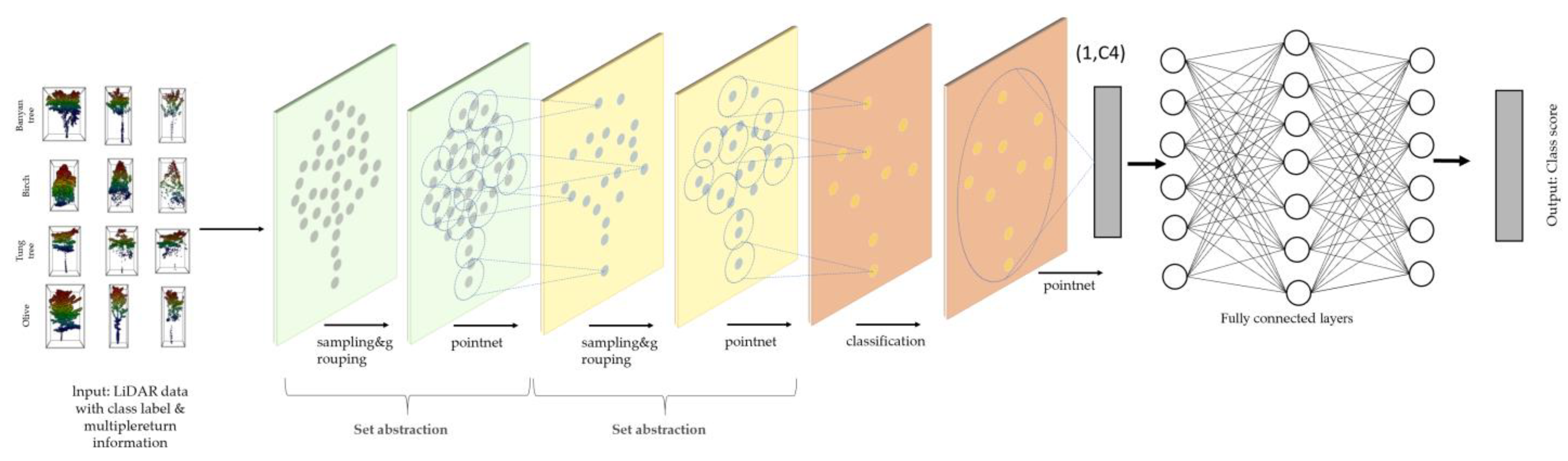
3. Model Training
4. Results
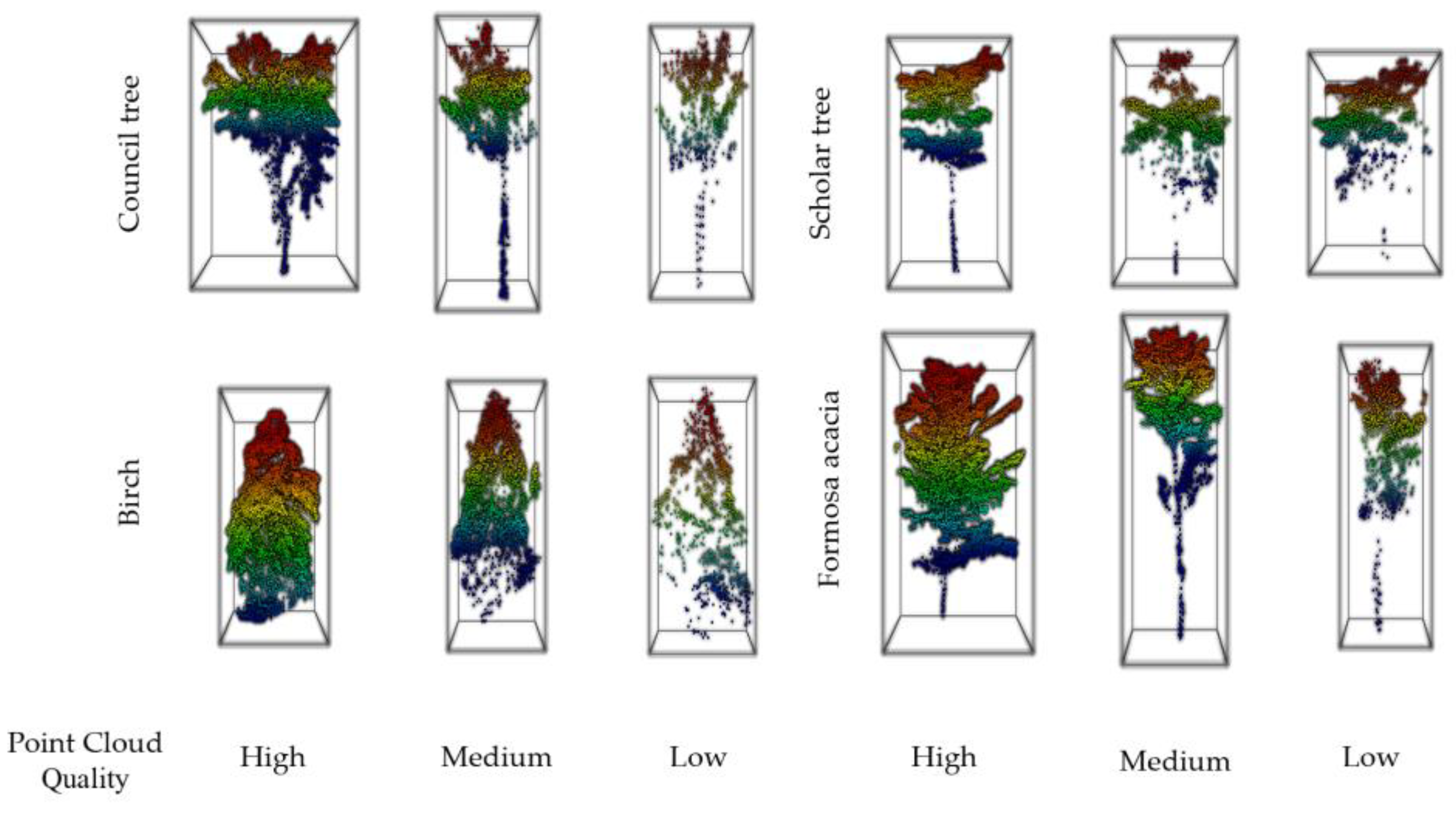
4.1. Results Acquired after Down-Sampling
4.2. Down-Sampling Results of Point Clouds after Enhancement
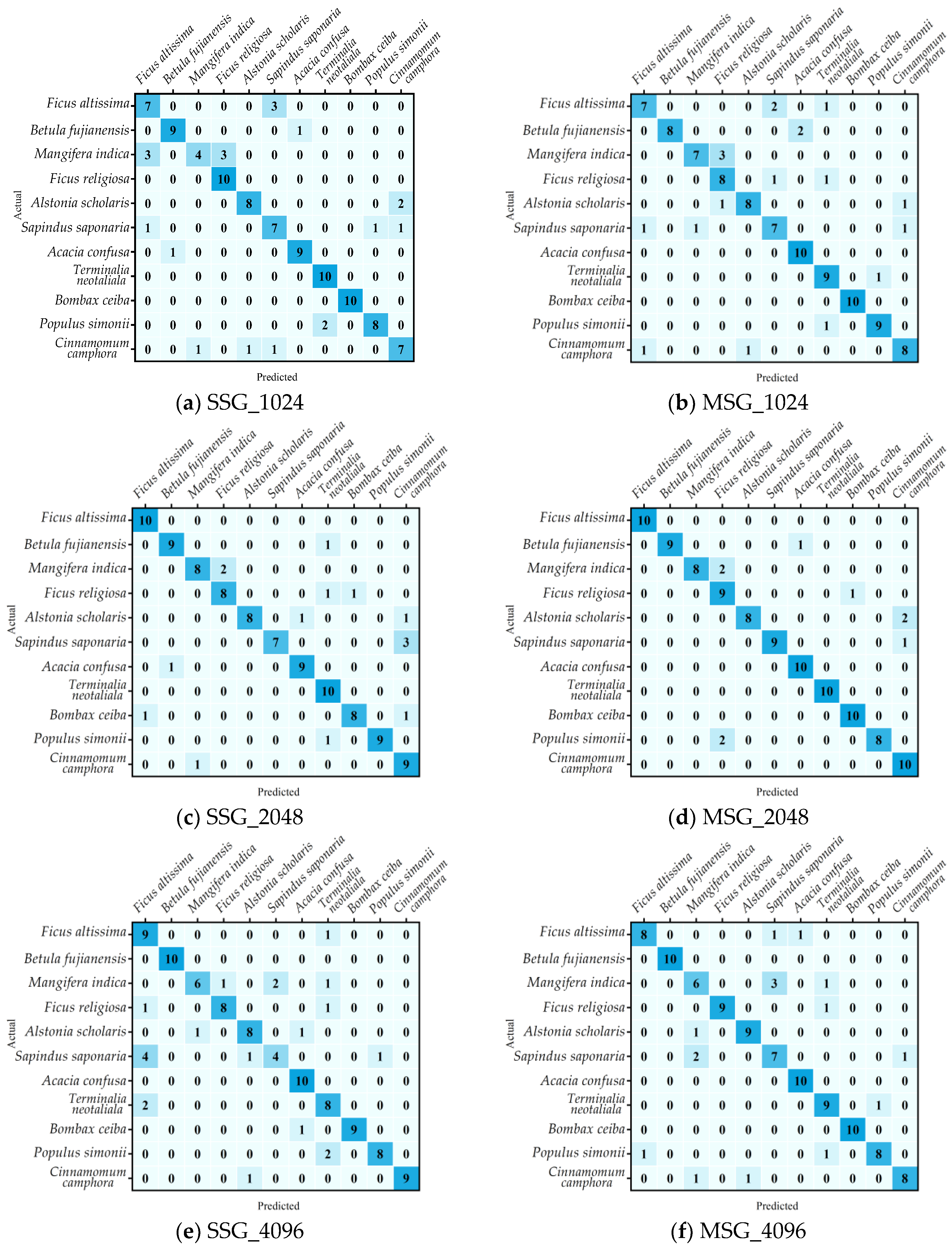
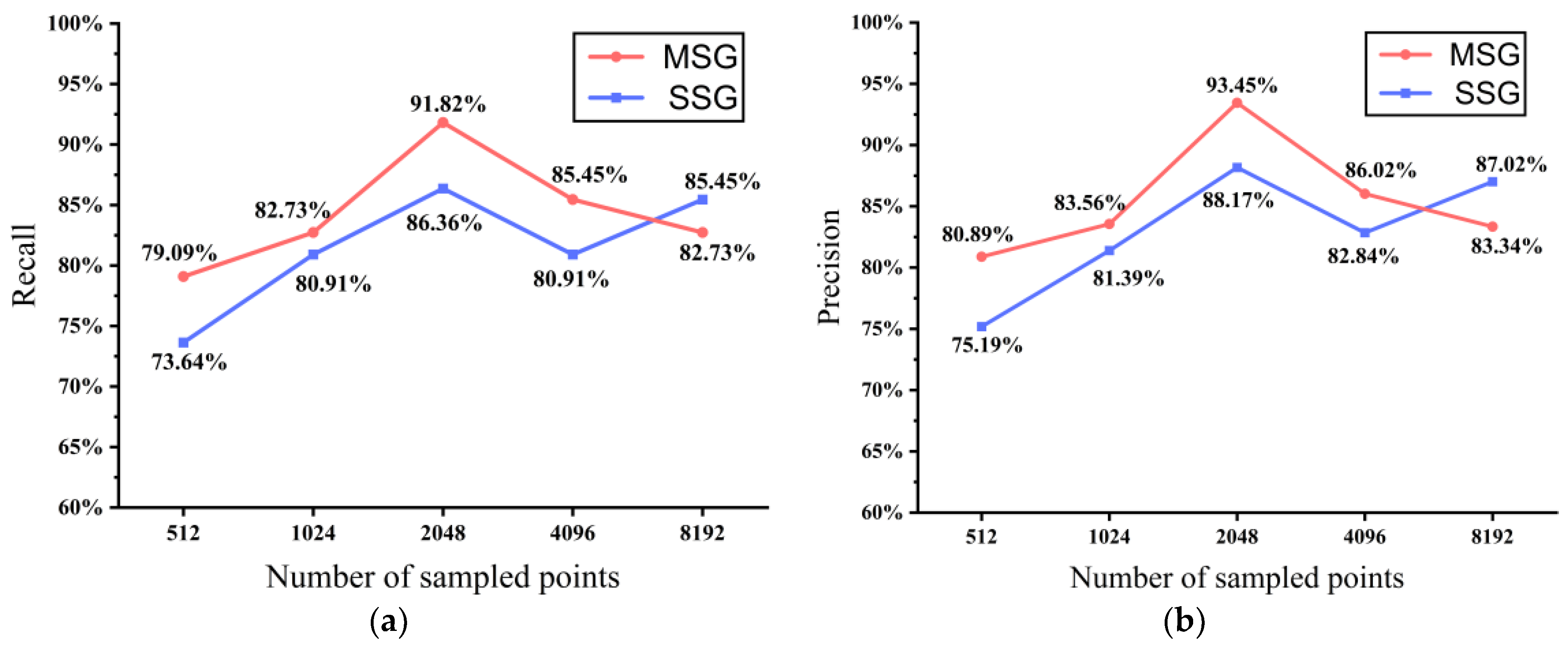
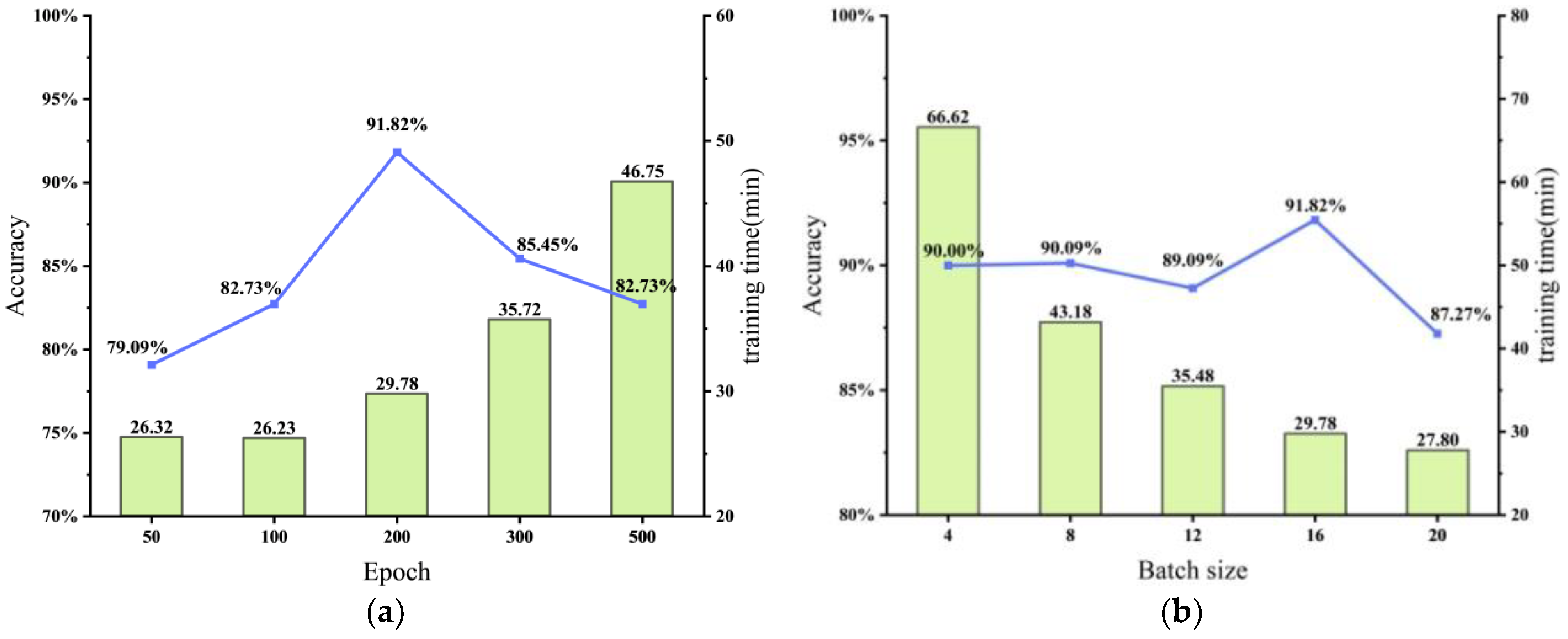
4.3. Comparison of the Results with Other Hyperparameters
5. Discussion
6. Conclusions
Author Contributions
Funding
Data Availability Statement
Acknowledgments
Conflicts of Interest
References
- Zhang, Y.; Pan, C.-L.; Liao, H.-T. Carbon neutrality policies and technologies: A scientometric analysis of social science disciplines. Front. Environ. Sci. 2021, 9, 1736. [Google Scholar] [CrossRef]
- Wu, W.; Zhu, Y.; Wang, Y. Spatio-temporal pattern, evolution and influencing factors of forest carbon sinks in Zhejiang Province, China. Forests 2023, 14, 445. [Google Scholar] [CrossRef]
- Roberge, C. Inventory Strategies for Monitoring and Evaluation of Forest Damage. Ph.D. Thesis, Swedish University of Agricultural Sciences, Uppsala, Sweden, 2017. [Google Scholar]
- Shi, Y.; Wang, S.; Zhou, S.; Kamruzzaman, M.M. Study on modeling method of forest tree image recognition based on CCD and theodolite. IEEE Access 2020, 8, 159067–159076. [Google Scholar] [CrossRef]
- Xu, H.; Qiang, S.; Han, Z.; Guo, J.; Huang, Z.; Sun, H.; He, S.; Ding, H.; Wu, H.; Wan, F.J.B. The status and causes of alien species invasion in China. Biodivers. Conserv. 2006, 15, 2893–2904. [Google Scholar] [CrossRef]
- Libby, R.; Sato, A.Y.; Alapai, L.; Brawner, W.P.; Carter, Y.Y.; Carter, K.A.; Tomich, K.; Ticktin, T. A Hawaiian tropical dry forest regenerates: Natural regeneration of endangered species under biocultural restoration. Sustainability 2022, 14, 1159. [Google Scholar] [CrossRef]
- Tewari, V.P. Forest inventory, assessment, and monitoring, and long-term forest observational studies, with special reference to India. For. Sci. Technol. 2016, 12, 24–32. [Google Scholar] [CrossRef]
- Gao, D.; Sun, Q.; Hu, B.; Zhang, S. A framework for agricultural pest and disease monitoring based on Internet-of-things and unmanned aerial vehicles. Sensors 2020, 20, 1487. [Google Scholar] [CrossRef] [PubMed]
- Cao, K.; Zhang, X. An improved res-UNet model for tree species classification using airborne high-resolution images. Remote Sens. 2020, 12, 1128. [Google Scholar] [CrossRef]
- Liu, Y.; Gong, W.; Hu, X.; Gong, J. Forest type identification with random forest using Sentinel-1A, Sentinel-2A, multi-temporal Landsat-8 and DEM data. Remote Sens. 2018, 10, 946. [Google Scholar] [CrossRef]
- Immitzer, M.; Vuolo, F.; Atzberger, C. First experience with Sentinel-2 data for crop and tree species classifications in Central Europe. Remote Sens. 2016, 8, 166. [Google Scholar] [CrossRef]
- Bolyn, C.; Michez, A.; Gaucher, P.; Lejeune, P.; Bonnet, S. Forest mapping and species composition using supervised per pixel classification of Sentinel-2 imagery. BASE 2018, 22, 172–187. [Google Scholar] [CrossRef]
- Immitzer, M.; Atzberger, C.; Koukal, T. Tree species classification with random forest using very high spatial resolution 8-band WorldView-2 satellite data. Remote Sens. 2012, 4, 2661–2693. [Google Scholar] [CrossRef]
- Ballanti, L.; Blesius, L.; Hines, E.; Kruse, B. Tree species classification using hyperspectral imagery: A comparison of two classifiers. Remote Sens. 2016, 8, 445. [Google Scholar] [CrossRef]
- Krahwinkler, P.; Rossmann, J. Tree Species Classification and Input Data Evaluation. Eur. J. Remote Sens. 2013, 46, 535–549. [Google Scholar] [CrossRef]
- Tuominen, S.; Näsi, R.; Honkavaara, E.; Balazs, A.; Hakala, T.; Viljanen, N.; Pölönen, I.; Saari, H.; Ojanen, H. Assessment of classifiers and remote sensing features of hyperspectral imagery and stereo-photogrammetric point clouds for recognition of tree species in a forest area of high species diversity. Remote Sens. 2018, 10, 714. [Google Scholar] [CrossRef]
- Pellikka, P.; King, D.J.; Leblanc, S.G. Quantification and reduction of bidirectional effects in aerial cir imagery of deciduous forest using two reference land surface types. Remote Sens. Rev. 2000, 19, 259–291. [Google Scholar] [CrossRef]
- Wehr, A.; Lohr, U. Airborne laser scanning—An introduction and overview. ISPRS J. Photogramm. 1999, 54, 68–82. [Google Scholar] [CrossRef]
- Korpela, I.; Ørka, H.O.; Maltamo, M.; Tokola, T.; Hyyppä, J. Tree species classification using airborne LiDAR–effects of stand and tree parameters, downsizing of training set, intensity normalization, and sensor type. Silva Fenn. 2010, 44, 319–339. [Google Scholar] [CrossRef]
- Budei, B.C.; St-Onge, B.; Hopkinson, C.; Audet, F.-A. Identifying the genus or species of individual trees using a three-wavelength airborne lidar system. Remote Sens. Environ. 2018, 204, 632–647. [Google Scholar] [CrossRef]
- Hovi, A.; Korhonen, L.; Vauhkonen, J.; Korpela, I. LiDAR waveform features for tree species classification and their sensitivity to tree- and acquisition related parameters. Remote Sens. Environ. 2016, 173, 224–237. [Google Scholar] [CrossRef]
- Blomley, R.; Hovi, A.; Weinmann, M.; Hinz, S.; Korpela, I.; Jutzi, B. Tree species classification using within crown localization of waveform LiDAR attributes. ISPRS J. Photogramm. 2017, 133, 142–156. [Google Scholar] [CrossRef]
- Kukkonen, M.; Maltamo, M.; Korhonen, L.; Packalen, P. Multispectral airborne LiDAR data in the prediction of boreal tree species composition. IEEE Trans. Geosci. Remote Sens. 2019, 57, 3462–3471. [Google Scholar] [CrossRef]
- Michałowska, M.; Rapiński, J. A review of tree species classification based on airborne LiDAR data and applied classifiers. Remote Sens. 2021, 13, 353. [Google Scholar] [CrossRef]
- Sanaa, F.; Imane, S.; Mohamed, B.; Kenza, A.E.K.; Souhail, K.; Lfalah, H.; Khadija, M. Biomass and carbon stock quantification in cork Oak Forest of Maamora using a new approach based on the combination of aerial laser scanning carried by unmanned aerial vehicle and terrestrial laser scanning data. Forests 2022, 13, 1211. [Google Scholar] [CrossRef]
- Kuma, P.; McDonald, A.J.; Morgenstern, O.; Querel, R.; Silber, I.; Flynn, C.J. Ground-based lidar processing and simulator framework for comparing models and observations (ALCF 1.0). Geosci. Model Dev. 2021, 14, 43–72. [Google Scholar] [CrossRef]
- Ruhan, A.; Du, W.; Ying, H.; Wei, B.; Shan, Y.; Dai, H. Estimation of aboveground biomass of individual trees by backpack LiDAR based on parameter-optimized quantitative structural models (AdQSM). Forests 2023, 14, 475. [Google Scholar] [CrossRef]
- Su, Y.; Guo, Q.; Jin, S.; Guan, H.; Sun, X.; Ma, Q.; Hu, T.; Wang, R.; Li, Y. The development and evaluation of a backpack LiDAR system for accurate and efficient forest inventory. IEEE Geosci. Remote Sens. Lett. 2021, 18, 1660–1664. [Google Scholar] [CrossRef]
- Okyay, U.; Telling, J.; Glennie, C.L.; Dietrich, W.E. Airborne lidar change detection: An overview of earth sciences applications. Earth Sci. Rev. 2019, 198, 102929. [Google Scholar] [CrossRef]
- Wu, H.; Yang, H.; Huang, S.; Zeng, D.; Liu, C.; Zhang, H.; Guo, C.; Chen, L. Classification of point clouds for indoor components using few labeled samples. Remote Sens. 2020, 12, 2181. [Google Scholar] [CrossRef]
- Seidel, D.; Annighöfer, P.; Thielman, A.; Seifert, Q.E.; Thauer, J.H.; Glatthorn, J.; Ehbrecht, M.; Kneib, T.; Ammer, C. Predicting tree species from 3D laser scanning point clouds using deep learning. Front. Plant Sci. 2021, 12, 635440. [Google Scholar] [CrossRef]
- Qi, C.R.; Su, H.; Mo, K.; Guibas, L.J. Pointnet: Deep learning on point sets for 3-d classification and segmentation. In Proceedings of the IEEE Conference on Computer Vision and Pattern Recognition, Honolulu, HI, USA, 21–26 July 2017; pp. 652–660. [Google Scholar]
- Qi, C.R.; Yi, L.; Su, H.; Guibas, L.J. Pointnet++: Deep hierarchical feature learning on point sets in a metric space. Adv. Neural Inf. Process. Syst. 2017, 30, 5105–5114. [Google Scholar]
- Shrestha, A.; Mahmood, A. Review of deep learning algorithms and architectures. IEEE Access 2019, 7, 53040–53065. [Google Scholar] [CrossRef]
- Zhou, X.; Dai, N.; Cheng, X.; Thompson, A.; Leach, R. Intelligent classification for three-dimensional metal powder particles. Powder Technol. 2022, 397, 117018. [Google Scholar] [CrossRef]
- Yang, J.; Li, Z.; Zhan, P.; Li, X.; Wang, K.; Han, J.; Yang, P. Proximal femur parameter measurement via improved PointNet++. Int. J. Med. Robot. Comput. Assist. Surg. 2022, 19, e2494. [Google Scholar] [CrossRef] [PubMed]
- Jing, Z.; Guan, H.; Zhao, P.; Li, D.; Yu, Y.; Zang, Y.; Wang, H.; Li, J. Multispectral LiDAR point cloud classification using SE-PointNet++. Remote Sens. 2021, 13, 2516. [Google Scholar] [CrossRef]
- Liu, B.; Chen, S.; Huang, H.; Tian, X. Tree species classification of backpack laser scanning data using the PointNet++ point cloud deep learning method. Remote Sens. 2022, 14, 3809. [Google Scholar] [CrossRef]
- LiDAR360—Point Cloud Processing Software. Available online: https://greenvalleyintl.com/LiDAR360/ (accessed on 5 February 2023).
- Chen, C.; Guo, J.; Wu, H.; Li, Y.; Shi, B. Performance comparison of filtering algorithms for high-density airborne LiDAR point clouds over complex LandScapes. Remote Sens. 2021, 13, 2663. [Google Scholar] [CrossRef]
- Nie, S.; Wang, C.; Dong, P.; Xi, X.; Luo, S.; Qin, H. A revised progressive TIN densification for filtering airborne LiDAR data. Measurement 2017, 104, 70–77. [Google Scholar] [CrossRef]
- Persson, A.; Holmgren, J.; Soderman, U. Detecting and measuring individual trees using an airborne laser scanner. Photogramm. Eng. Remote Sens. 2002, 68, 925–932. [Google Scholar]
- Zhao, Y.; Chen, H.; Zeng, L.; Li, Z.; Chen, G.; Chen, H.; Li, Z. Improved Pointnet++ algorithm based on density related-farthest point sampling. SSRN Electron. J. 2023. preprint. [Google Scholar] [CrossRef]
- Dovrat, O.; Lang, I.; Avidan, S. Learning to sample. In Proceedings of the IEEE/CVF Conference on Computer Vision and Pattern Recognition, Long Beach, CA, USA, 16–17 June 2019; pp. 2755–2764. [Google Scholar] [CrossRef]
- Sarode, V.; Li, X.; Goforth, H.; Aoki, Y.; Srivatsan, R.A.; Lucey, S.; Choset, H. Pcrnet: Point Cloud Registration Network Using Pointnet Encoding. arXiv 2019, arXiv:1908.07906. [Google Scholar]
- Zhang, Y.; Liang, G.; Salem, T.; Jacobs, N. Defense-pointnet: Protecting pointnet against adversarial attacks. In Proceedings of the 2019 IEEE International Conference on Big Data (Big Data), Los Angeles, CA, USA, 9–12 December 2019; pp. 5654–5660. [Google Scholar] [CrossRef]
- Li, Z.; Li, W.; Liu, H.; Wang, Y.; Gui, G. Optimized PointNet for 3D Object Classification; Springer: Cham, Switzerland, 2019; pp. 271–278. [Google Scholar]
- Cao, X.; Wang, W.; Nagao, K.; Nakamura, R. Psnet: A style transfer network for point cloud stylization on geometry and color. In Proceedings of the IEEE/CVF Winter Conference on Applications of Computer Vision, Snowmass Village, CO, USA, 1–5 March 2020; pp. 3326–3334. [Google Scholar] [CrossRef]
- Qian, G.; Li, Y.; Peng, H.; Mai, J.; Hammoud, H.; Elhoseiny, M.; Ghanem, B. Pointnext: Revisiting Pointnet++ with improved training and scaling strategies. Adv. Neural Inf. Process. Syst. 2022, 35, 23192–23204. [Google Scholar]
- Sakharova, E.K.; Nurlyeva, D.D.; Fedorova, A.A.; Yakubov, A.R.; Kanev, A.I. Issues of Tree Species Classification from LiDAR Data Using Deep Learning Model; Springer: Cham, Switzerland, 2022; pp. 319–324. [Google Scholar]
- Zhan, D.; Liang, D.; Jin, H.; Wu, X.; Mbbos, G.C.N. MBBOS-GCN: Minimum bounding box over-segmentation—Graph convolution 3D point cloud deep learning model. J. Appl. Remote Sens. 2022, 16, 016502. [Google Scholar] [CrossRef]
- Yao, W.; Krzystek, P.; Heurich, M. Tree species classification and estimation of stem volume and DBH based on single tree extraction by exploiting airborne full-waveform LiDAR data. Remote Sens. Environ. 2012, 123, 368–380. [Google Scholar] [CrossRef]
- Terryn, L.; Calders, K.; Disney, M.; Origo, N.; Malhi, Y.; Newnham, G.; Raumonen, P.; Kerblom, M.Å.; Verbeeck, H. Tree species classification using structural features derived from terrestrial laser scanning. ISPRS J. Photogramm. 2020, 168, 170–181. [Google Scholar] [CrossRef]
- Zou, X.; Cheng, M.; Wang, C.; Xia, Y.; Li, J. Tree classification in complex forest point clouds based on deep learning. IEEE Geosci. Remote Sens. Lett. 2017, 14, 2360–2364. [Google Scholar] [CrossRef]
- Mizoguchi, T.; Ishii, A.; Nakamura, H.; Inoue, T.; Takamatsu, H. Lidar-based individual tree species classification using convolutional neural network. In Proceedings of the Videometrics, Range Imaging, and Applications XIV, Munich, Germany, 26–27 June 2017; pp. 193–199. [Google Scholar]
- Diab, A.; Kashef, R.; Shaker, A. Deep Learning for LiDAR Point Cloud Classification in Remote Sensing. Sensors 2022, 22, 7868. [Google Scholar] [CrossRef]
- Chen, J.; Chen, Y.; Liu, Z. Classification of typical tree species in laser point cloud based on deep learning. Remote Sens. 2021, 13, 4750. [Google Scholar] [CrossRef]
- Liu, M.; Han, Z.; Chen, Y.; Liu, Z.; Han, Y. Tree species classification of LiDAR data based on 3D deep learning. Measurement 2021, 177, 109301. [Google Scholar] [CrossRef]
- Xi, Z.; Hopkinson, C.; Rood, S.B.; Peddle, D.R. See the forest and the trees: Effective machine and deep learning algorithms for wood filtering and tree species classification from terrestrial laser scanning. ISPRS J. Photogramm. 2020, 168, 1–16. [Google Scholar] [CrossRef]
- Chen, Y.; Hu, V.T.; Gavves, E.; Mensink, T.; Mettes, P.; Yang, P.; Snoek, C.G.M. PointMixup: Augmentation for Point Clouds; Springer: Cham, Switzerland, 2020; pp. 330–345. [Google Scholar]
- Li, R.; Li, X.; Heng, P.-A.; Fu, C.-W. Pointaugment: An auto-augmentation framework for point cloud classification. In Proceedings of the IEEE/CVF Conference on Computer Vision and Pattern Recognition, Seattle, WA, USA, 13–19 June 2020; pp. 6377–6386. [Google Scholar] [CrossRef]
- Xiao, A.; Huang, J.; Guan, D.; Cui, K.; Lu, S.; Shao, L. PolarMix: A General Data Augmentation Technique for LiDAR Point Clouds. arXiv 2022, arXiv:2208.00223. [Google Scholar]
- Arief, H.A.A.; Indahl, U.G.; Strand, G.-H.; Tveite, H. Addressing overfitting on point cloud classification using Atrous XCRF. ISPRS J. Photogramm. 2019, 155, 90–101. [Google Scholar] [CrossRef]
- Guan, H.; Yu, Y.; Ji, Z.; Li, J.; Zhang, Q. Deep learning-based tree classification using mobile LiDAR data. Remote Sens. Lett. 2015, 6, 864–873. [Google Scholar] [CrossRef]


| Model | SAL-1500 |
|---|---|
| Measurement Rate | 2,000,000 points/s |
| Scanning Speed | 400 lines/s |
| Flight Altitude | 200 m |
| System Relative Accuracy | 20 mm |
| Field of View | 360° |
| Tree Species | Scientific Names | Number of Points | ||
|---|---|---|---|---|
| Average | Maximum | Minimum | ||
| Birch | Betula fujianensis | 4232 | 13,642 | 933 |
| Bodhi tree | Ficus religiosa | 4838 | 11,345 | 1539 |
| Scholar tree | Alstonia scholaris | 1687 | 5278 | 398 |
| Formosa acacia | Acacia confusa | 3763 | 8975 | 1113 |
| Terminalia neotaliala | Terminalia neotaliala | 6017 | 15,509 | 1350 |
| Simon poplar | Populus simonii | 4534 | 10,499 | 664 |
| Camphor tree | Cinnamomum camphora | 1965 | 5426 | 607 |
| Council tree | Ficus altissima | 2253 | 6558 | 701 |
| Mango tree | Mangifera indica | 4079 | 10,020 | 1509 |
| Wingleaf soapberry | Sapindus saponaria | 3367 | 8030 | 1120 |
| Cotton tree | Bombax ceiba | 511 | 1454 | 134 |
| Others | 5951 | 38,124 | 152 | |
| Tree Species | Scientific Names | Number of Samples | Average Number of Points | ||
|---|---|---|---|---|---|
| Train | Test | Train | Test | ||
| Birch | Betula fujianensis | 40 | 10 | 4453 | 2947 |
| Bodhi tree | Ficus religiosa | 40 | 10 | 4573 | 5602 |
| Scholar tree | Alstonia scholaris | 40 | 10 | 1731 | 1232 |
| Formosa acacia | Acacia confusa | 40 | 10 | 3451 | 5012 |
| Terminalia neotaliala | Terminalia neotaliala | 40 | 10 | 5982 | 6159 |
| Simon poplar | Populus simonii | 38 | 10 | 4399 | 5048 |
| Camphor tree | Cinnamomum camphora | 40 | 10 | 1496 | 1858 |
| Council tree | Ficus altissima | 40 | 10 | 2236 | 1924 |
| Mango tree | Mangifera indica | 40 | 10 | 4335 | 4063 |
| Wingleaf soapberry | Sapindus saponaria | 38 | 10 | 3633 | 2356 |
| Cotton tree | Bombax ceiba | 40 | 10 | 525 | 391 |
| Total | 438 | 110 | / | / | |
| Hyperparameter | Value | Declaration |
|---|---|---|
| Training Model | SSG/MSG | Simplified sampling and grouping Multi-scale sampling and grouping |
| Batch size | 4\8\12\16\20 | Number of batches in each epoch |
| Number of points | 512\1024\2048\4096\8192 | Number of points per individual tree sample |
| Epoch | 50\100\200\300\500 | Number of times to traverse the entire training dataset during training |
| Optimizer | Adam | An algorithm to update and calculate the internal parameters of the model to reduce the training error |
| Learning rate | 0.001 | The step size to update in each iteration |
| Decay rate | 0.0001 | Used to reduce the learning rate to help the model converge better |
| Recall | Precision | Accuracy | |
|---|---|---|---|
| SSG_512 | 73.64 | 73.64 | 75.19 |
| MSG_512 | 79.09 | 79.09 | 80.89 |
| Recall | Precision | Accuracy | |
|---|---|---|---|
| SSG_1024 | 80.91 | 80.91 | 81.39 |
| MSG_1024 | 82.73 | 82.73 | 83.56 |
| SSG_2048 | 86.36 | 88.17 | 88.17 |
| MSG_2048 | 91.82 | 93.45 | 93.45 |
| SSG_4096 | 81.82 | 81.82 | 85.48 |
| MSG_4096 | 87.27 | 87.27 | 90.99 |
| SSG_8192 | 80.91 | 80.91 | 82.84 |
| MSG_8192 | 85.45 | 85.45 | 86.02 |
Disclaimer/Publisher’s Note: The statements, opinions and data contained in all publications are solely those of the individual author(s) and contributor(s) and not of MDPI and/or the editor(s). MDPI and/or the editor(s) disclaim responsibility for any injury to people or property resulting from any ideas, methods, instructions or products referred to in the content. |
© 2023 by the authors. Licensee MDPI, Basel, Switzerland. This article is an open access article distributed under the terms and conditions of the Creative Commons Attribution (CC BY) license (https://creativecommons.org/licenses/by/4.0/).
Share and Cite
Fan, Z.; Wei, J.; Zhang, R.; Zhang, W. Tree Species Classification Based on PointNet++ and Airborne Laser Survey Point Cloud Data Enhancement. Forests 2023, 14, 1246. https://doi.org/10.3390/f14061246
Fan Z, Wei J, Zhang R, Zhang W. Tree Species Classification Based on PointNet++ and Airborne Laser Survey Point Cloud Data Enhancement. Forests. 2023; 14(6):1246. https://doi.org/10.3390/f14061246
Chicago/Turabian StyleFan, Zhongmou, Jinhuang Wei, Ruiyang Zhang, and Wenxuan Zhang. 2023. "Tree Species Classification Based on PointNet++ and Airborne Laser Survey Point Cloud Data Enhancement" Forests 14, no. 6: 1246. https://doi.org/10.3390/f14061246
APA StyleFan, Z., Wei, J., Zhang, R., & Zhang, W. (2023). Tree Species Classification Based on PointNet++ and Airborne Laser Survey Point Cloud Data Enhancement. Forests, 14(6), 1246. https://doi.org/10.3390/f14061246