
Spatial Predictions of Human and Natural-Caused Wildfire Likelihood across Montana (USA)

 , ,
, , 
 , and
, and
Abstract
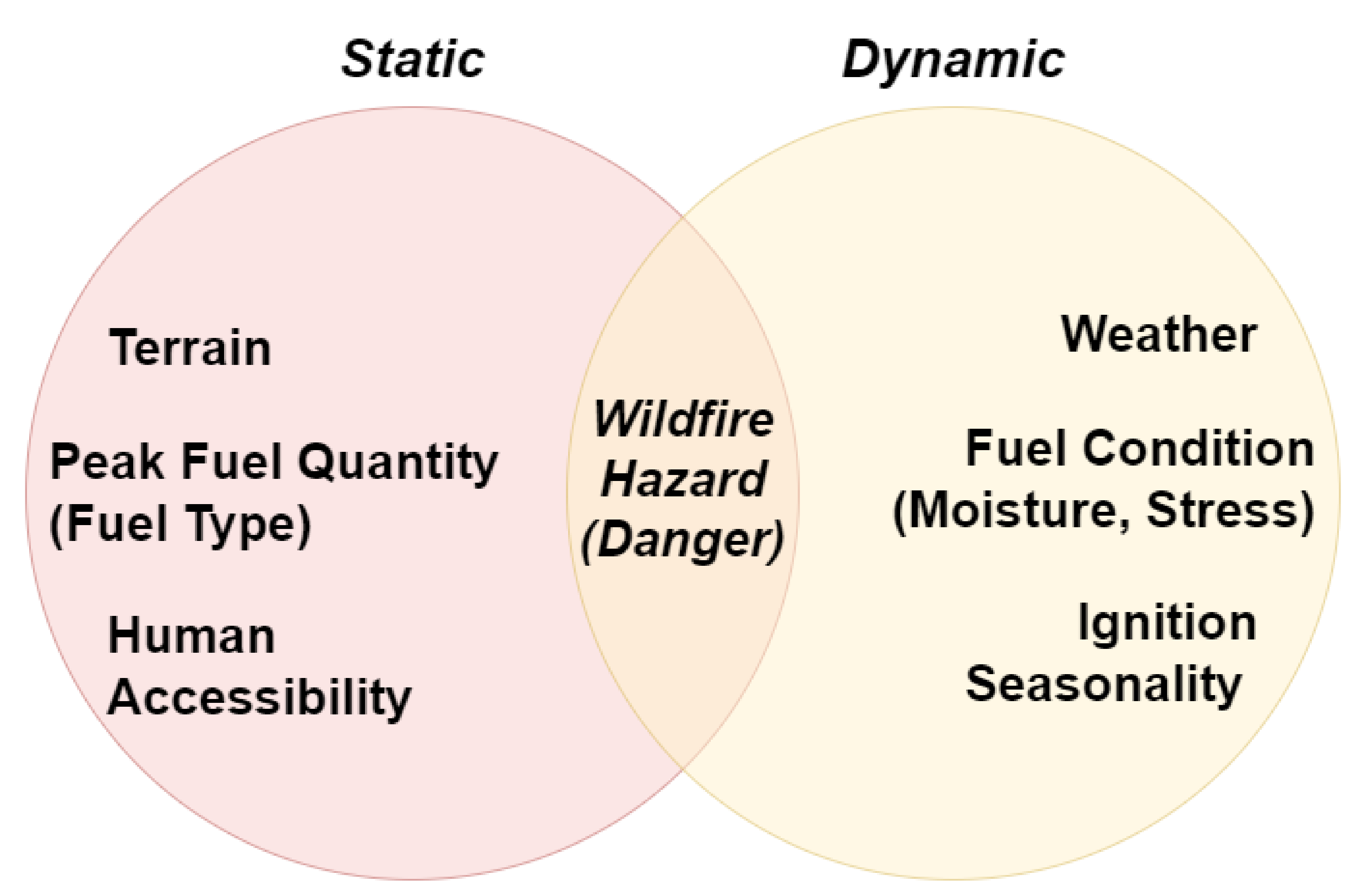
:1. Introduction
2. Material and Methods
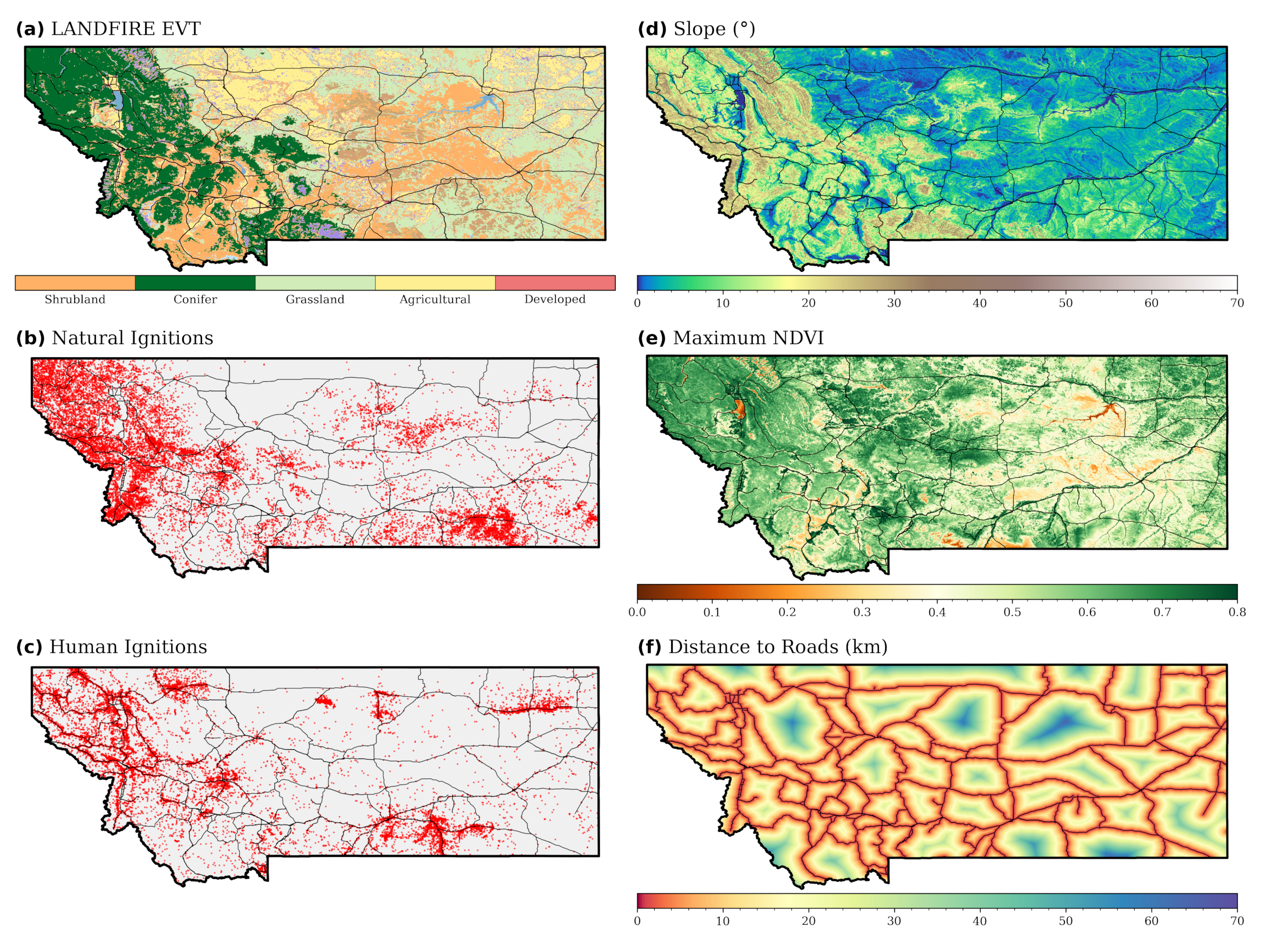
2.1. Study Area
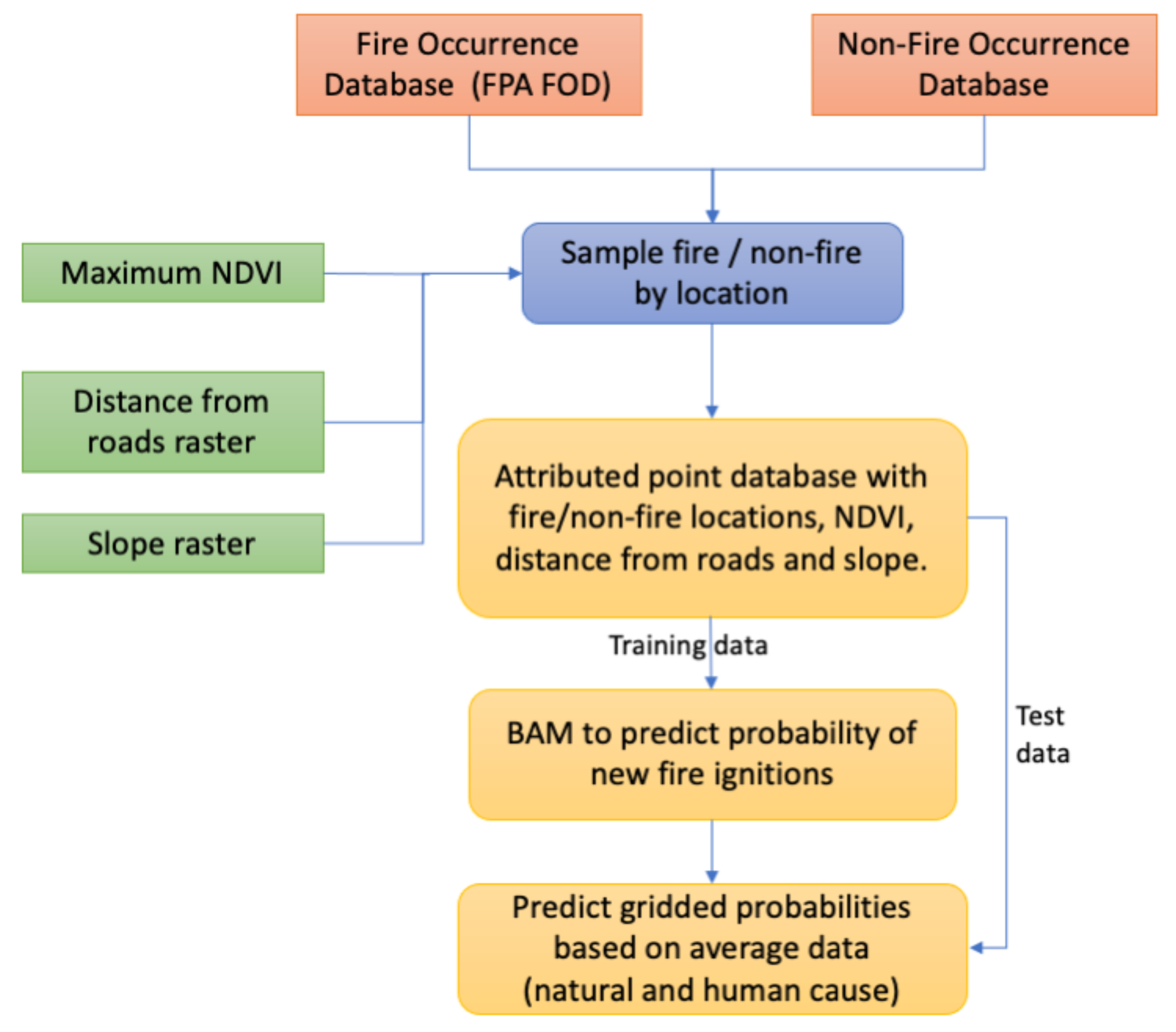
2.2. Data Preparation
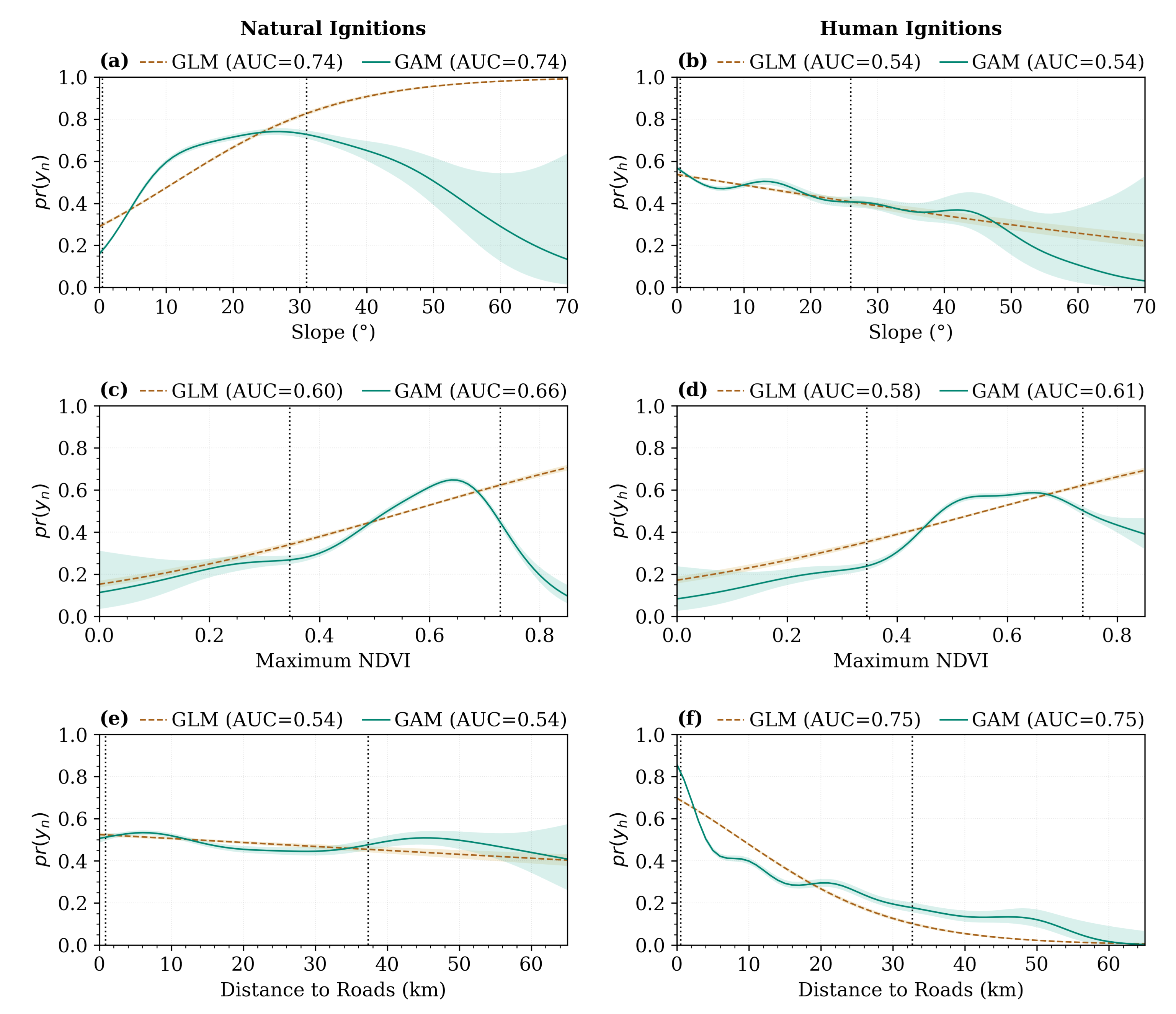
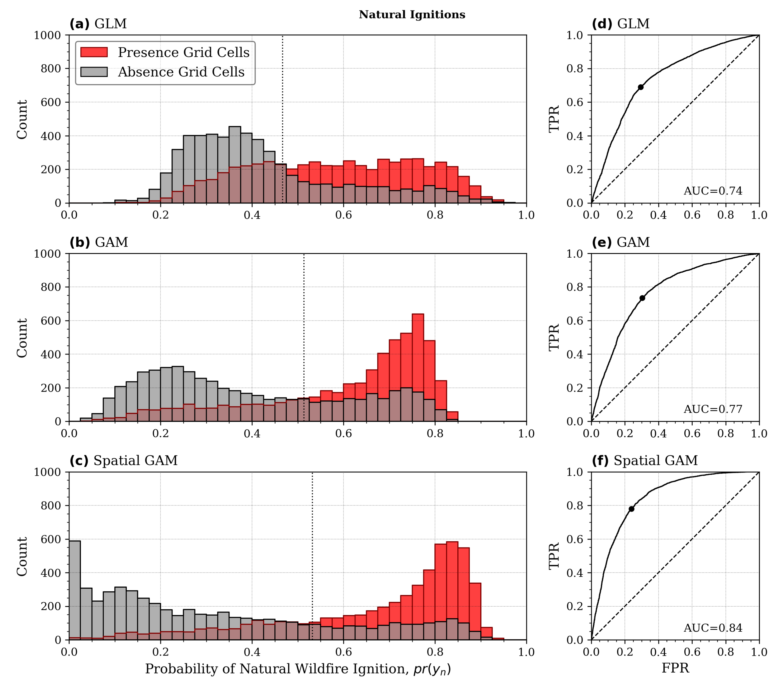
2.3. Model Construction and Evaluation
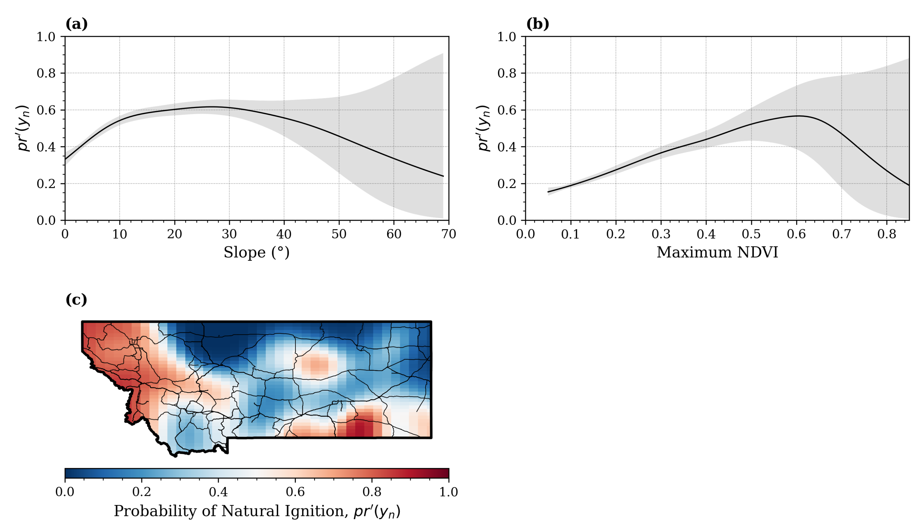
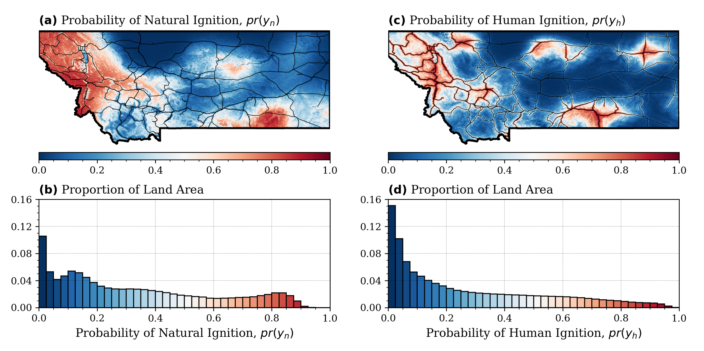
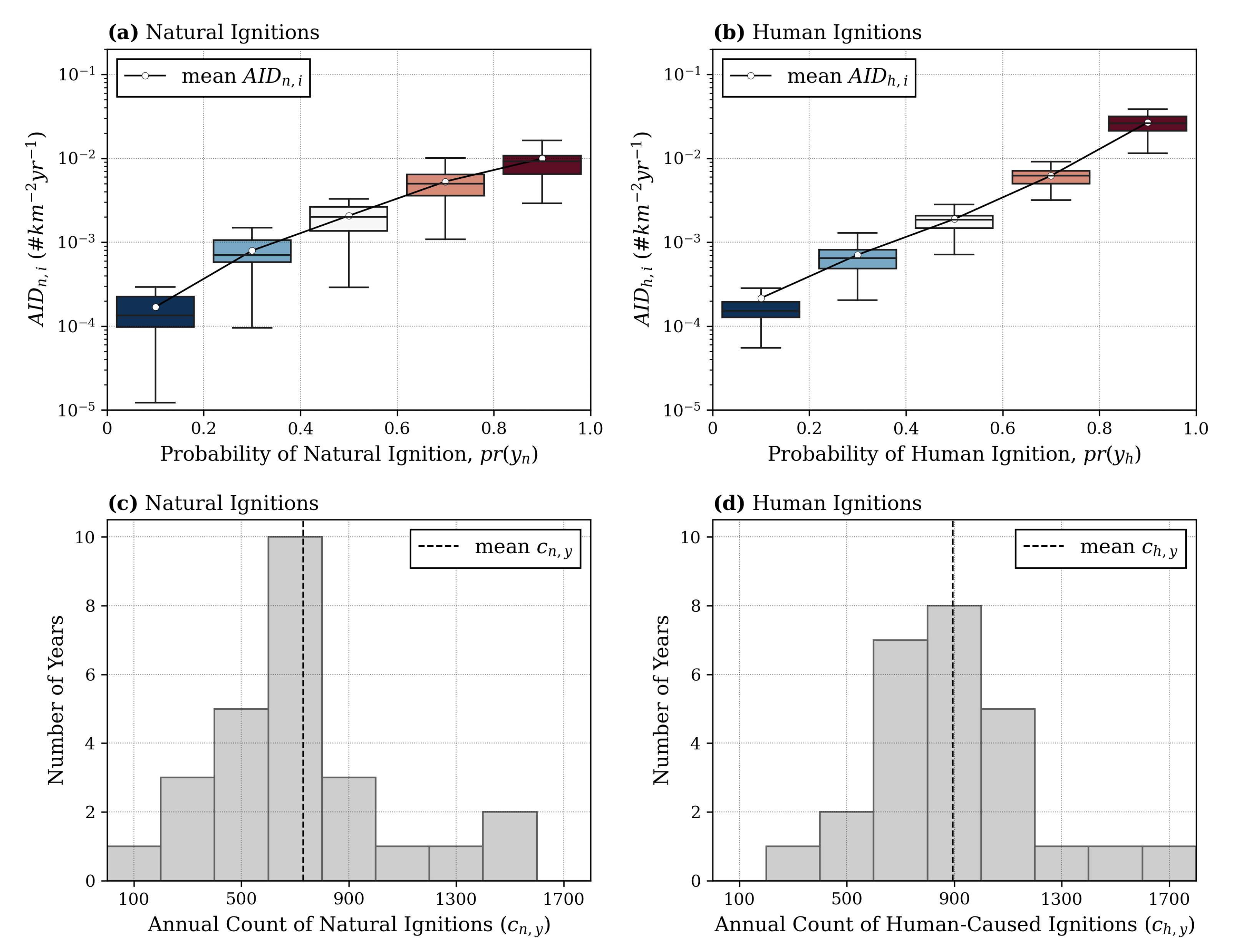
3. Results
4. Discussion
5. Conclusions
Author Contributions
Funding
Institutional Review Board Statement
Informed Consent Statement
Data Availability Statement
Conflicts of Interest
References
- Krawchuk, M.A.; Moritz, M.A.; Parisien, M.A.; Van Dorn, J.; Hayhoe, K. Global pyrogeography: The current and future distribution of wildfire. PLoS ONE 2009, 4, e5102. [Google Scholar] [CrossRef]
- Krawchuk, M.A.; Moritz, M.A. Constraints on global fire activity vary across a resource gradient. Ecology 2011, 92, 121–132. [Google Scholar] [CrossRef] [PubMed]
- Archibald, S.; Lehmann, C.E.R.; Gómez-dans, J.L.; Bradstock, R.A. Defining pyromes and global syndromes of fire regimes. Proc. Natl. Acad. Sci. USA 2013, 110, 6445–6447. [Google Scholar] [CrossRef]
- Page, S.E.; Siegert, F.; Rieley, J.O.; Boehm, H.D.V.; Jaya, A.; Limin, S. The amount of carbon released from peat and forest fires in Indonesia during 1997. Nature 2002, 420, 61–65. [Google Scholar] [CrossRef]
- Bladon, K.D.; Emelko, M.B.; Silins, U.; Stone, M. Wildfire and the Future of Water Supply. Environ. Sci. Technol. 2014, 48, 8936–8943. [Google Scholar] [CrossRef] [PubMed]
- Smith, H.G.; Sheridan, G.J.; Lane, P.N.; Nyman, P.; Haydon, S. Wildfire effects on water quality in forest catchments: A review with implications for water supply. J. Hydrol. 2011, 396, 170–192. [Google Scholar] [CrossRef]
- McLauchlan, K.K.; Higuera, P.E.; Miesel, J.; Rogers, B.M.; Schweitzer, J.; Shuman, J.K.; Tepley, A.J.; Varner, J.M.; Veblen, T.T.; Adalsteinsson, S.A.; et al. Fire as a fundamental ecological process: Research advances and frontiers. J. Ecol. 2020, 108, 2047–2069. [Google Scholar] [CrossRef]
- Kramer, H.A.; Mockrin, M.H.; Alexandre, P.M.; Radeloff, V.C. High wildfire damage in interface communities in California. Int. J. Wildland Fire 2019, 28, 641–650. [Google Scholar] [CrossRef]
- McLennan, J.; Ryan, B.; Bearman, C.; Toh, K. Should we leave now? Behavioral factors in evacuation under wildfire threat. Fire Technol. 2019, 55, 487–516. [Google Scholar] [CrossRef]
- Riley, K.L.; Thompson, M.P.; Scott, J.H.; Gilbertson-Day, J.W. A model-based framework to evaluate alternative wildfire suppression strategies. Resources 2018, 7, 4. [Google Scholar] [CrossRef]
- Tedim, F.; Leone, V.; Coughlan, M.; Bouillon, C.; Xanthopoulos, G.; Royé, D.; Correia, F.J.; Ferreira, C. Extreme wildfire events: The definition. In Extreme Wildfire Events and Disasters; Elsevier: Amsterdam, The Netherlands, 2020; Chapter 1; pp. 3–29. [Google Scholar] [CrossRef]
- Belval, E.J.; Stonesifer, C.S.; Calkin, D.E. Fire suppression resource scarcity: Current metrics and future performance indicators. Forests 2020, 11, 217. [Google Scholar] [CrossRef]
- Syphard, A.D.; Keeley, J.E. Location, timing and extent of wildfire vary by cause of ignition. Int. J. Wildland Fire 2015, 24, 37–47. [Google Scholar] [CrossRef]
- Balch, J.K.; Bradley, B.A.; Abatzoglou, J.T.; Chelsea Nagy, R.; Fusco, E.J.; Mahood, A.L. Human-started wildfires expand the fire niche across the United States. Proc. Natl. Acad. Sci. USA 2017, 114, 2946–2951. [Google Scholar] [CrossRef] [PubMed]
- Mitchener, L.J.; Parker, A.J. Climate, lightning, and wildfire in the national forests of the southeastern United States: 1989–1998. Phys. Geogr. 2005, 26, 147–162. [Google Scholar] [CrossRef]
- Schultz, C.J.; Nauslar, N.J.; Wachter, J.B.; Hain, C.R.; Bell, J.R. Spatial, temporal and electrical characteristics of lightning in reported lightning-initiated wildfire events. Fire 2019, 2, 18. [Google Scholar] [CrossRef] [PubMed]
- Prestemon, J.; Hawbaker, T.; Bowden, M.; Carpenter, J.; Brooks, M.; Abt, K.; Sutphen, R.; Scranton, S. Wildfire Ignitions: A Review of the Science and Recommendations for Empirical Modeling; USDA-Forest Service, Southern Research Station: Asheville, NC, USA, 2013; p. 20.
- Faivre, N.; Jin, Y.; Goulden, M.L.; Randerson, J.T. Controls on the spatial pattern of wildfire ignitions in Southern California. Int. J. Wildland Fire 2014, 23, 799–811. [Google Scholar] [CrossRef]
- Benefield, A.; Chen, J. Examining the influence of outdoor recreation on anthropogenic wildfire regime of the southern Rocky Mountains. Nat. Hazards 2022, 111, 523–545. [Google Scholar] [CrossRef]
- Keeley, J.E.; Syphard, A.D. Historical patterns of wildfire ignition sources in California ecosystems. Int. J. Wildland Fire 2018, 27, 781–799. [Google Scholar] [CrossRef]
- Ganteaume, A.; Camia, A.; Jappiot, M.; San-Miguel-Ayanz, J.; Long-Fournel, M.; Lampin, C. A review of the main driving factors of forest fire ignition over Europe. Environ. Manag. 2013, 51, 651–662. [Google Scholar] [CrossRef]
- Barreto, J.S.; Armenteras, D. Open Data and Machine Learning to Model the Occurrence of Fire in the Ecoregion of “Llanos Colombo—Venezolanos”. Remote Sens. 2020, 12, 3921. [Google Scholar] [CrossRef]
- Viegas, D.X. Slope and wind effects on fire propagation. Int. J. Wildland Fire 2004, 13, 143–156. [Google Scholar] [CrossRef]
- Syphard, A.D.; Radeloff, V.C.; Keeley, J.E.; Hawbaker, T.J.; Clayton, M.K.; Stewart, S.I.; Hammer, R.B. Human influence on California fire regimes. Ecol. Appl. 2007, 17, 1388–1402. [Google Scholar] [CrossRef]
- Narayanaraj, G.; Wimberly, M.C. Influences of forest roads on the spatial patterns of human-and lightning-caused wildfire ignitions. Appl. Geogr. 2012, 32, 878–888. [Google Scholar] [CrossRef]
- Thompson, M.P.; Gannon, B.M.; Caggiano, M.D. Forest roads and operational wildfire response planning. Forests 2021, 12, 110. [Google Scholar] [CrossRef]
- Briones-Herrera, C.I.; Vega-Nieva, D.J.; Monjarás-Vega, N.A.; Flores-Medina, F.; Lopez-Serrano, P.M.; Corral-Rivas, J.J.; Carrillo-Parra, A.; Pulgarin-Gámiz, M.Á.; Alvarado-Celestino, E.; González-Cabán, A.; et al. Modeling and mapping forest fire occurrence from aboveground carbon density in Mexico. Forests 2019, 10, 402. [Google Scholar] [CrossRef]
- Costafreda-Aumedes, S.; Comas, C.; Vega-Garcia, C. Human-caused fire occurrence modelling in perspective: A review. Int. J. Wildland Fire 2017, 26, 983–998. [Google Scholar] [CrossRef]
- Archibald, S.; Roy, D.P.; van Wilgen, B.W.; Scholes, R.J. What limits fire? An examination of drivers of burnt area in Southern Africa. Glob. Chang. Biol. 2009, 15, 613–630. [Google Scholar] [CrossRef]
- Kahiu, M.N.; Hanan, N. Fire in sub-Saharan Africa: The fuel, cure and connectivity hypothesis. Glob. Ecol. Biogeogr. 2018, 27, 946–957. [Google Scholar] [CrossRef]
- Silverman, N.L.; Maneta, M.P.; Chen, S.H.; Harper, J.T. Dynamically downscaled winter precipitation over complex terrain of the Central Rockies of Western Montana, USA. Water Resour. Res. 2013, 49, 458–470. [Google Scholar] [CrossRef]
- Heim, R. Widespread general rains in Montana during the summer. Natl. Weather Dig. 1986, 11, 21–27. [Google Scholar]
- Crawford, C.J.; Griffin, D.; Kipfmueller, K.F. Capturing season-specific precipitation signals in the northern Rocky Mountains, USA, using earlywood and latewood tree rings. J. Geophys. Res. Biogeosci. 2015, 120, 428–440. [Google Scholar] [CrossRef]
- Kalashnikov, D.A.; Loikith, P.C.; Catalano, A.J. A 30-Yr Climatology of Meteorological Conditions Associated with Lightning Days in the Interior Western United States. J. Clim. 2020, 33, 3771–3785. [Google Scholar] [CrossRef]
- Rollins, M.G. LANDFIRE: A nationally consistent vegetation, wildland fire, and fuel assessment. Int. J. Wildland Fire 2009, 18, 235–249. [Google Scholar] [CrossRef]
- Short, K.C. A spatial database of wildfires in the United States, 1992–2011. Earth Syst. Sci. Data 2014, 6, 1–27. [Google Scholar] [CrossRef]
- Gorelick, N.; Hancher, M.; Dixon, M.; Ilyushchenko, S.; Thau, D.; Moore, R. Google Earth Engine: Planetary-scale geospatial analysis for everyone. Remote Sens. Environ. 2017, 202, 18–27. [Google Scholar] [CrossRef]
- Xu, C.; Li, Y.; Hu, J.; Yang, X.; Sheng, S.; Liu, M. Evaluating the difference between the normalized difference vegetation index and net primary productivity as the indicators of vegetation vigor assessment at landscape scale. Environ. Monit. Assess. 2012, 184, 1275–1286. [Google Scholar] [CrossRef] [PubMed]
- Monjarás-Vega, N.A.; Briones-Herrera, C.I.; Vega-Nieva, D.J.; Calleros-Flores, E.; Corral-Rivas, J.J.; López-Serrano, P.M.; Pompa-García, M.; Rodríguez-Trejo, D.A.; Carrillo-Parra, A.; González-Cabán, A.; et al. Predicting forest fire kernel density at multiple scales with geographically weighted regression in Mexico. Sci. Total Environ. 2020, 718, 137313. [Google Scholar] [CrossRef] [PubMed]
- US Census Bureau. TIGER/Line Shapefiles. 2015. Available online: https://www.census.gov/geographies/mapping-files/time-series/geo/tiger-line-file.html (accessed on 2 June 2022).
- Syphard, A.D.; Radeloff, V.C.; Keuler, N.S.; Taylor, R.S.; Hawbaker, T.J.; Stewart, S.I.; Clayton, M.K. Predicting spatial patterns of fire on a southern California landscape. Int. J. Wildland Fire 2008, 17, 602–613. [Google Scholar] [CrossRef]
- Bar Massada, A.; Syphard, A.D.; Stewart, S.I.; Radeloff, V.C. Wildfire ignition-distribution modelling: A comparative study in the Huron–Manistee National Forest, Michigan, USA. Int. J. Wildland Fire 2012, 22, 174–183. [Google Scholar] [CrossRef]
- Vilar, L.; Woolford, D.G.; Martell, D.L.; Martín, M.P. A model for predicting human-caused wildfire occurrence in the region of Madrid, Spain. Int. J. Wildland Fire 2010, 19, 325–337. [Google Scholar] [CrossRef]
- R Core Team. R: A Language and Environment for Statistical Computing; R Foundation for Statistical Computing: Vienna, Austria, 2021. [Google Scholar]
- Wood, S. Generalized Additive Models: An Introduction with R, 2nd ed.; Chapman and Hall/CRC: New York, NY, USA, 2017. [Google Scholar]
- Wood, S.N.; Goude, Y.; Shaw, S. Generalized additive models for large data sets. J. R. Stat. Society. Ser. C Appl. Stat. 2015, 64, 139–155. [Google Scholar] [CrossRef]
- Wood, S.N. Fast stable restricted maximum likelihood and marginal likelihood estimation of semiparametric generalized linear models. J. R. Stat. Soc. Ser. B Stat. Methodol. 2011, 73, 3–36. [Google Scholar] [CrossRef]
- Hogland, J.; Anderson, N.; Affleck, D.L.; St Peter, J. Using Forest Inventory Data with Landsat 8 Imagery to Map Longleaf Pine Forest Characteristics in Georgia, USA. Remote Sens. 2019, 11, 1803. [Google Scholar] [CrossRef]
- Bradley, A.P. The Use of the Area Under the ROC Curve in the Evaluation of Machine Learning Algorithms. Pattern Recogn. 1997, 30, 1145–1159. [Google Scholar] [CrossRef]
- Bradstock, R.A. A biogeographic model of fire regimes in Australia: Current and future implications. Glob. Ecol. Biogeogr. 2010, 19, 145–158. [Google Scholar] [CrossRef]
- Holz, A.; Kitzberger, T.; Paritsis, J.; Veblen, T.T. Ecological and climatic controls of modern wildfire activity patterns across southwestern South America. Ecosphere 2012, 3, 1–25. [Google Scholar] [CrossRef]
- Pausas, J.G.; Ribeiro, E. The global fire–productivity relationship. Glob. Ecol. Biogeogr. 2013, 22, 728–736. [Google Scholar] [CrossRef]
- De Vasconcelos, M.P.; Silva, S.; Tome, M.; Alvim, M.; Pereira, J.C. Spatial prediction of fire ignition probabilities: Comparing logistic regression and neural networks. Photogramm. Eng. Remote Sens. 2001, 67, 73–81. [Google Scholar]
- Grala, K.; Grala, R.K.; Hussain, A.; Cooke, W.H.; Varner, J.M. Impact of human factors on wildfire occurrence in Mississippi, United States. For. Policy Econ. 2017, 81, 38–47. [Google Scholar] [CrossRef]
- Juan, P.; Mateu, J.; Saez, M. Pinpointing spatio-temporal interactions in wildfire patterns. Stoch. Environ. Res. Risk Assess. 2012, 26, 1131–1150. [Google Scholar] [CrossRef]
- Martín, Y.; Zúñiga-Antón, M.; Rodrigues Mimbrero, M. Modelling temporal variation of fire-occurrence towards the dynamic prediction of human wildfire ignition danger in northeast Spain. Geomat. Nat. Hazards Risk 2019, 10, 385–411. [Google Scholar] [CrossRef]
- Jolly, W.M.; Freeborn, P.H.; Page, W.G.; Butler, B.W. Severe Fire Danger Index: A Forecastable Metric to Inform Firefighter and Community Wildfire Risk Management. Fire 2019, 2, 47. [Google Scholar] [CrossRef]
- Parisien, M.A.; Snetsinger, S.; Greenberg, J.A.; Nelson, C.R.; Schoennagel, T.; Dobrowski, S.Z.; Moritz, M.A. Spatial variability in wildfire probability across the western United States. Int. J. Wildland Fire 2012, 21, 313–327. [Google Scholar] [CrossRef]
- Jaafari, A.; Pourghasemi, H.R. 28 - Factors Influencing Regional-Scale Wildfire Probability in Iran: An Application of Random Forest and Support Vector Machine. In Spatial Modeling in GIS and R for Earth and Environmental Sciences; Pourghasemi, H.R., Gokceoglu, C., Eds.; Elsevier: Amsterdam, The Netherlands, 2019; pp. 607–619. [Google Scholar] [CrossRef]
- Elia, M.; D’Este, M.; Ascoli, D.; Giannico, V.; Spano, G.; Ganga, A.; Colangelo, G.; Lafortezza, R.; Sanesi, G. Estimating the probability of wildfire occurrence in Mediterranean landscapes using Artificial Neural Networks. Environ. Impact Assess. Rev. 2020, 85, 106474. [Google Scholar] [CrossRef]


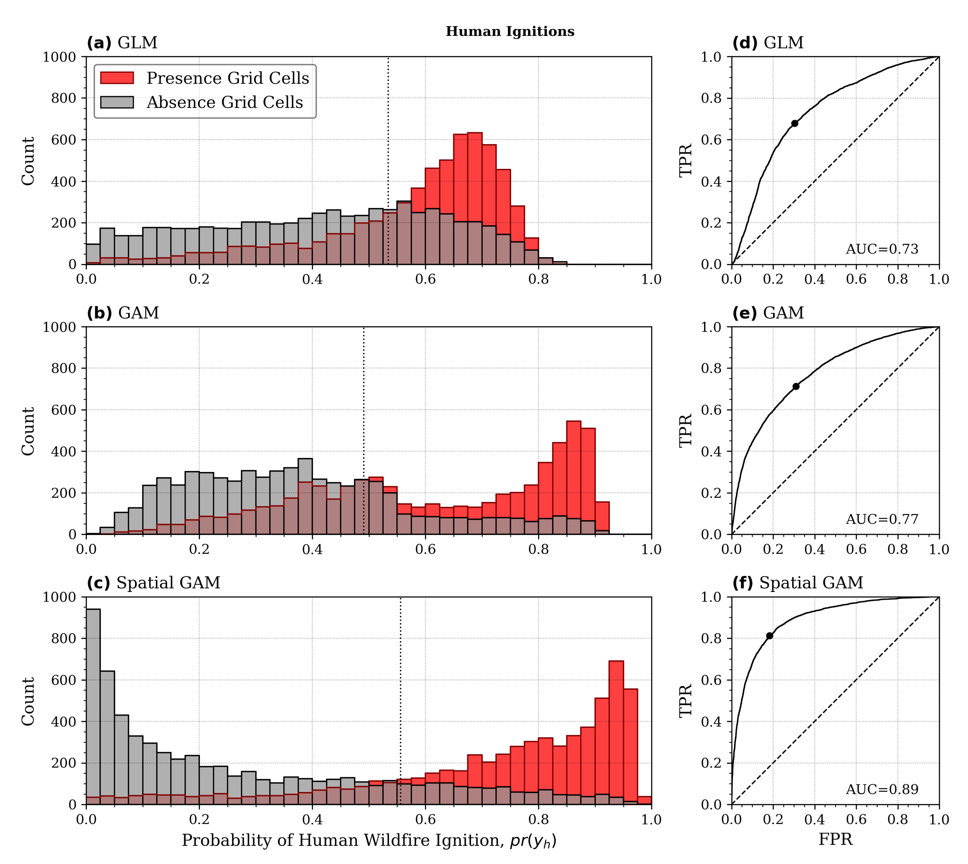
| Version | Cause | Formula | AUC |
|---|---|---|---|
| GLM | Natural Human | 0.74 0.73 | |
| GAM | Natural Human | 0.77 0.77 | |
| Spatial GAM | Natural Human | 0.84 0.89 |
Publisher’s Note: MDPI stays neutral with regard to jurisdictional claims in published maps and institutional affiliations. |
© 2022 by the authors. Licensee MDPI, Basel, Switzerland. This article is an open access article distributed under the terms and conditions of the Creative Commons Attribution (CC BY) license (https://creativecommons.org/licenses/by/4.0/).
Share and Cite
Jiménez-Ruano, A.; Jolly, W.M.; Freeborn, P.H.; Vega-Nieva, D.J.; Monjarás-Vega, N.A.; Briones-Herrera, C.I.; Rodrigues, M. Spatial Predictions of Human and Natural-Caused Wildfire Likelihood across Montana (USA). Forests 2022, 13, 1200. https://doi.org/10.3390/f13081200
Jiménez-Ruano A, Jolly WM, Freeborn PH, Vega-Nieva DJ, Monjarás-Vega NA, Briones-Herrera CI, Rodrigues M. Spatial Predictions of Human and Natural-Caused Wildfire Likelihood across Montana (USA). Forests. 2022; 13(8):1200. https://doi.org/10.3390/f13081200
Chicago/Turabian StyleJiménez-Ruano, Adrián, William M. Jolly, Patrick H. Freeborn, Daniel José Vega-Nieva, Norma Angélica Monjarás-Vega, Carlos Iván Briones-Herrera, and Marcos Rodrigues. 2022. "Spatial Predictions of Human and Natural-Caused Wildfire Likelihood across Montana (USA)" Forests 13, no. 8: 1200. https://doi.org/10.3390/f13081200
APA StyleJiménez-Ruano, A., Jolly, W. M., Freeborn, P. H., Vega-Nieva, D. J., Monjarás-Vega, N. A., Briones-Herrera, C. I., & Rodrigues, M. (2022). Spatial Predictions of Human and Natural-Caused Wildfire Likelihood across Montana (USA). Forests, 13(8), 1200. https://doi.org/10.3390/f13081200