
Exploring the Optimal Feature Combination of Tree Species Classification by Fusing Multi-Feature and Multi-Temporal Sentinel-2 Data in Changbai Mountain


Abstract
:1. Introduction
2. Materials and Methods
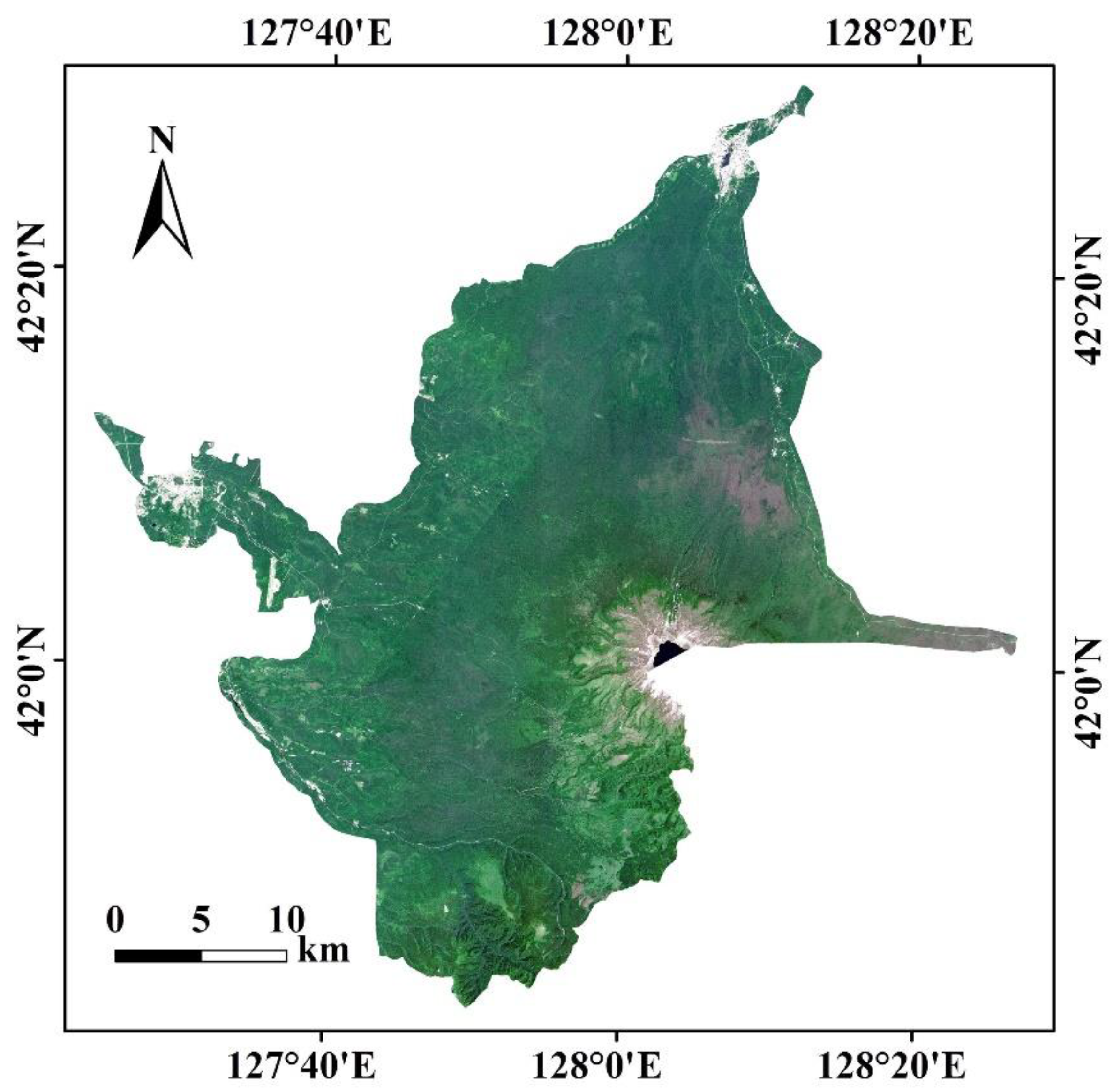
2.1. Study Area
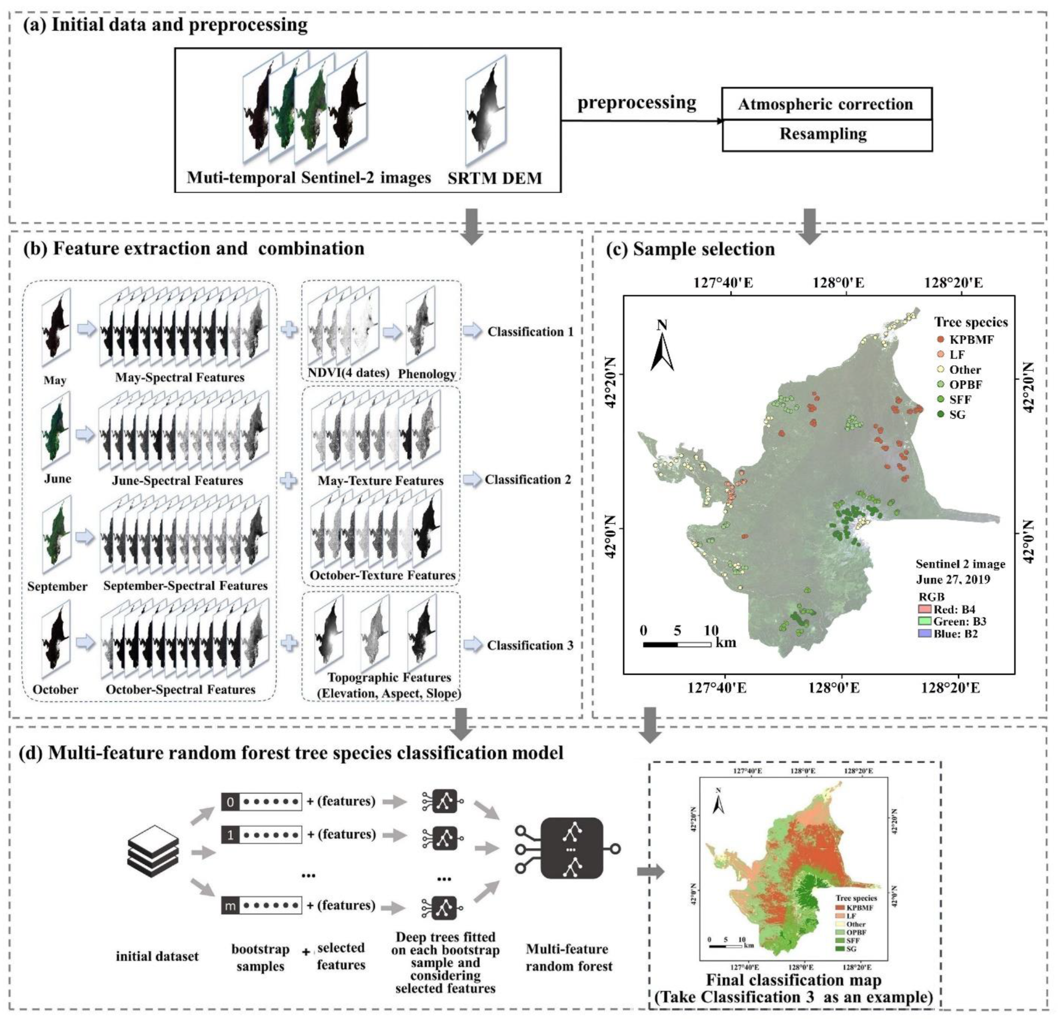
2.2. Data and Pre-Processing
2.3. Methodology
2.3.1. Separability of Spectral Features
2.3.2. Extraction of Phenological Features
2.3.3. Extraction of Texture Features
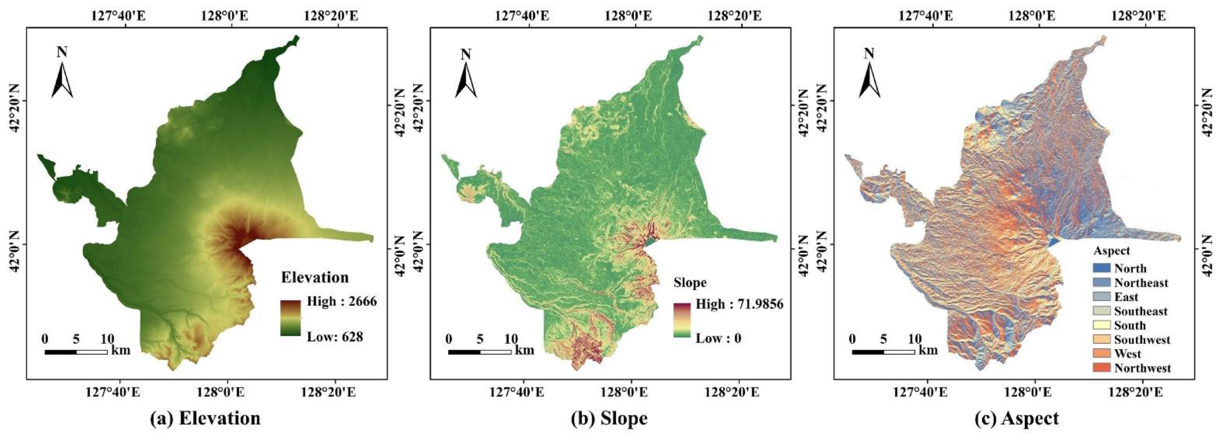
2.3.4. Extraction of Topographic Features
2.3.5. Random Forest
3. Results
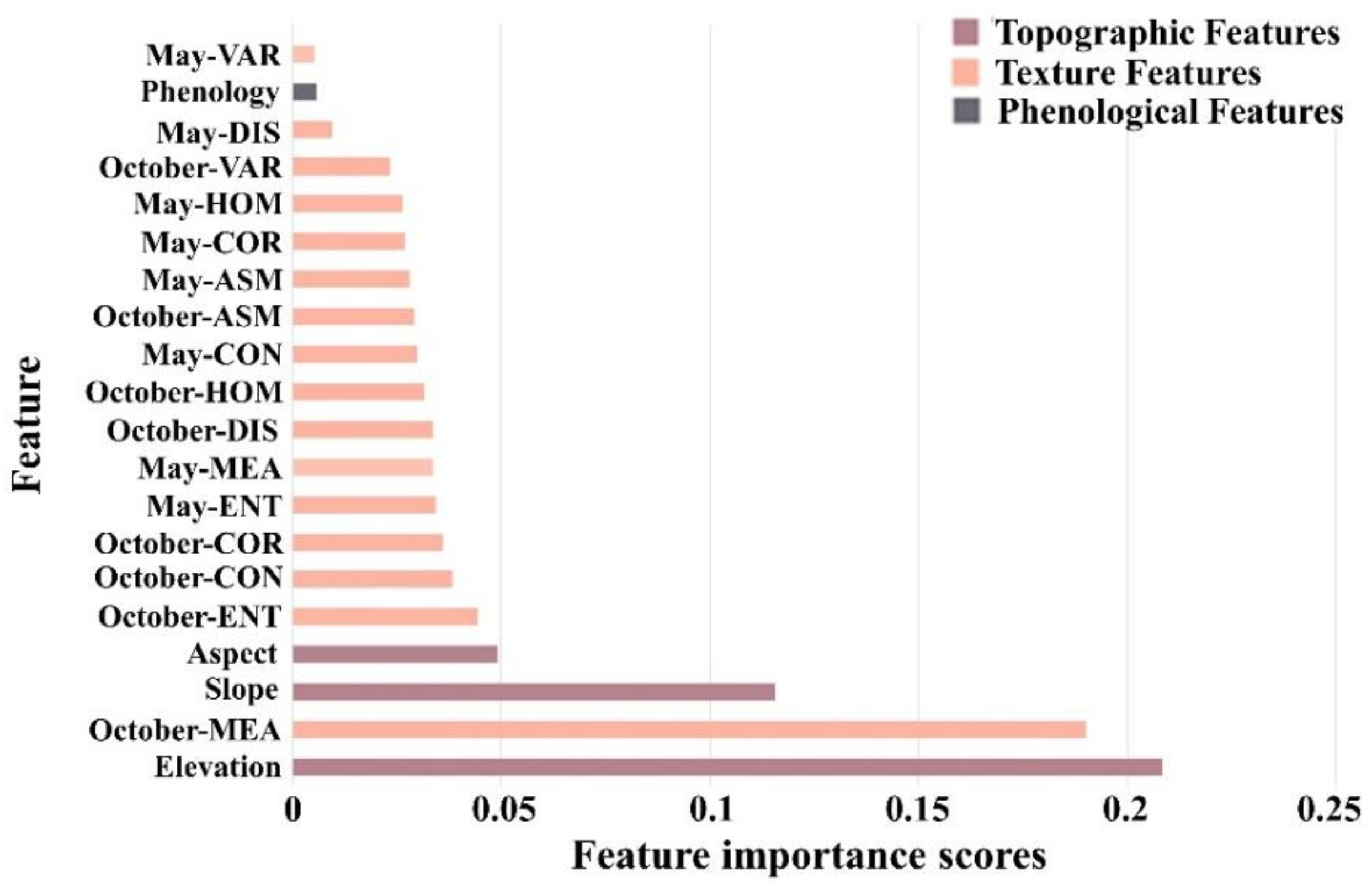
3.1. Feature Importance
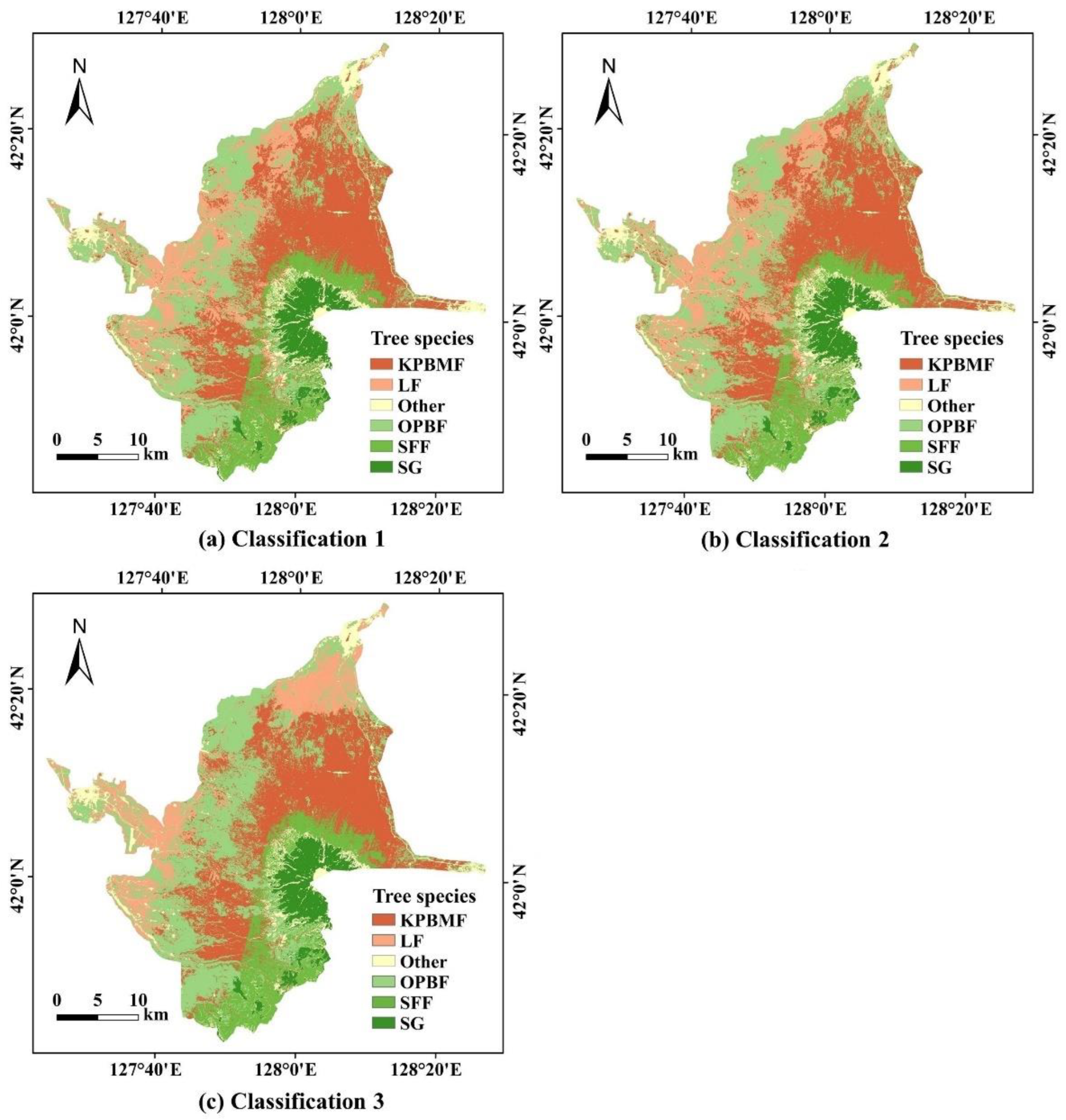
3.2. Tree Species Classification
3.3. Area Statistical Results of Tree Species
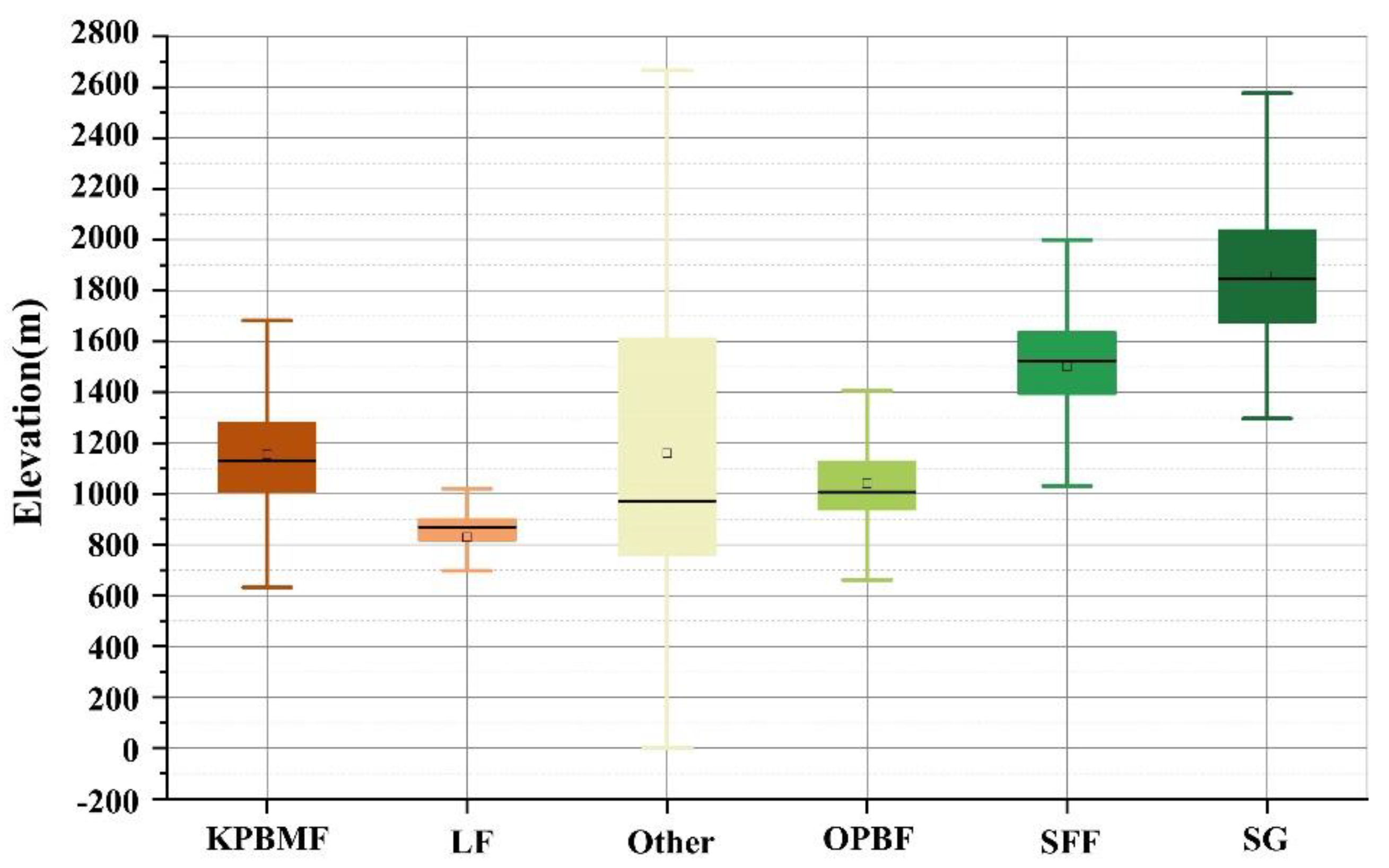
3.4. Topographic Statistical Results of Tree Species
3.4.1. Elevation Factor
3.4.2. Slope Factor
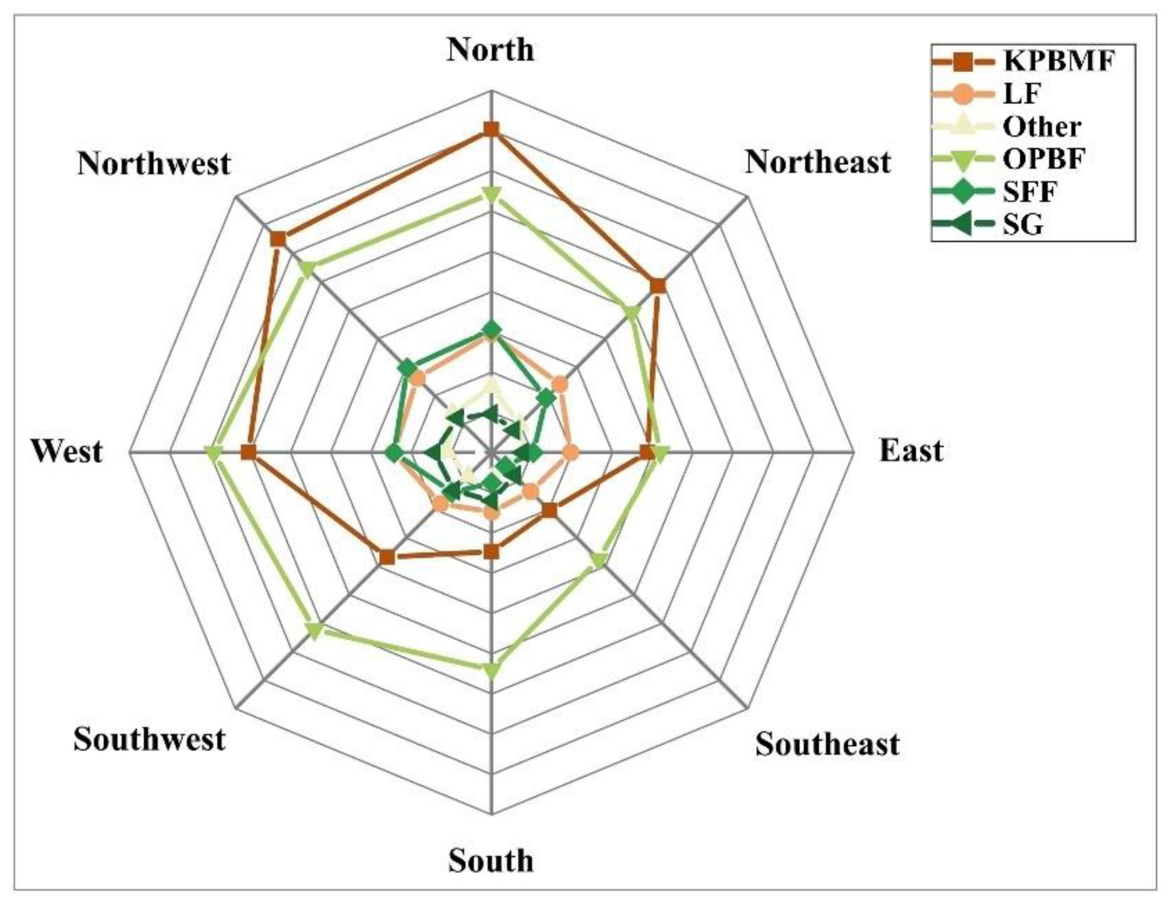
3.4.3. Aspect Factor
4. Discussion
5. Conclusions
Author Contributions
Funding
Institutional Review Board Statement
Informed Consent Statement
Data Availability Statement
Conflicts of Interest
References
- Ottosen, T.B.; Petch, G.; Hanson, M.; Skjoth, C.A. Tree cover mapping based on Sentinel-2 images demonstrate high thematic accuracy in Europe. Int. J. Appl. Earth Obs. Geoinf. 2020, 84, 101947. [Google Scholar] [CrossRef] [PubMed]
- Sprott, A.H.; Piwowar, J.M. How to recognize different types of trees from quite a long way away: Combining UAV and spaceborne imagery for stand-level tree species identification. J. Unmanned Veh. Syst. 2021, 9, 166–181. [Google Scholar] [CrossRef]
- Wang, M.C.; Zhang, X.Y.; Niu, X.F.; Wang, F.Y.; Zhang, X.Q. Scene Classification of High-Resolution Remotely Sensed Image Based on ResNet. J. Geovis. Spat. Anal. 2019, 3, 16. [Google Scholar] [CrossRef]
- Cho, M.A.; Mathieu, R.; Asner, G.P.; Naidoo, L.; van Aardt, J.; Ramoelo, A.; Debba, P.; Wessels, K.; Main, R.; Smit, I.P.J.; et al. Mapping tree species composition in South African savannas using an integrated airborne spectral and LiDAR system. Remote Sens. Environ. 2012, 125, 214–226. [Google Scholar] [CrossRef]
- Turner, W.; Spector, S.; Gardiner, N.; Fladeland, M.; Sterling, E.; Steininger, M. Remote sensing for biodiversity science and conservation. Trends Ecol. Evol. 2003, 18, 306–314. [Google Scholar] [CrossRef]
- Axelsson, A.; Lindberg, E.; Reese, H.; Olsson, H. Tree species classification using Sentinel-2 imagery and Bayesian inference. Int. J. Appl. Earth Obs. Geoinf. 2021, 100, 102318. [Google Scholar] [CrossRef]
- Xi, Y.; Ren, C.; Wang, Z.; Wei, S.; Bai, J.; Zhang, B.; Xiang, H.; Chen, L. Mapping tree species composition using OHS-1 hyperspectral data and deep learning algorithms in Changbai mountains, Northeast China. Forests 2019, 10, 818. [Google Scholar] [CrossRef] [Green Version]
- Breidenbach, J.; Waser, L.T.; Debella-Gilo, M.; Schumacher, J.; Rahlf, J.; Hauglin, M.; Puliti, S.; Astrup, R. National mapping and estimation of forest area by dominant tree species using Sentinel-2 data. Can. J. For. Res. 2021, 51, 365–379. [Google Scholar] [CrossRef]
- Rodriguez-Galiano, V.F.; Ghimire, B.; Rogan, J.; Chica-Olmo, M.; Rigol-Sanchez, J.P. An assessment of the effectiveness of a random forest classifier for land-cover classification. Isprs J. Photogramm. Remote Sens. 2012, 67, 93–104. [Google Scholar] [CrossRef]
- Grabska, E.; Hostert, P.; Pflugmacher, D.; Ostapowicz, K. Forest Stand Species Mapping Using the Sentinel-2 Time Series. Remote Sens. 2019, 11, 1197. [Google Scholar] [CrossRef] [Green Version]
- Plakman, V.; Janssen, T.; Brouwer, N.; Veraverbeke, S. Mapping Species at an Individual-Tree Scale in a Temperate Forest, Using Sentinel-2 Images, Airborne Laser Scanning Data, and Random Forest Classification. Remote Sens. 2020, 12, 3710. [Google Scholar] [CrossRef]
- Wessel, M.; Brandmeier, M.; Tiede, D. Evaluation of Different Machine Learning Algorithms for Scalable Classification of Tree Types and Tree Species Based on Sentinel-2 Data. Remote Sens. 2018, 10, 1419. [Google Scholar] [CrossRef] [Green Version]
- Boyd, D.S.; Danson, F.M. Satellite remote sensing of forest resources: Three decades of research development. Prog. Phys. Geogr. 2005, 29, 1–26. [Google Scholar] [CrossRef]
- Immitzer, M.; Neuwirth, M.; Bock, S.; Brenner, H.; Vuolo, F.; Atzberger, C. Optimal Input Features for Tree Species Classification in Central Europe Based on Multi-Temporal Sentinel-2 Data. Remote Sens. 2019, 11, 2599. [Google Scholar] [CrossRef] [Green Version]
- Immitzer, M.; Vuolo, F.; Atzberger, C. First Experience with Sentinel-2 Data for Crop and Tree Species Classifications in Central Europe. Remote Sens. 2016, 8, 166. [Google Scholar] [CrossRef]
- Persson, M.; Lindberg, E.; Reese, H. Tree Species Classification with Multi-Temporal Sentinel-2 Data. Remote Sens. 2018, 10, 1794. [Google Scholar] [CrossRef] [Green Version]
- Kollert, A.; Bremer, M.; Low, M.; Rutzinger, M. Exploring the potential of land surface phenology and seasonal cloud free composites of one year of Sentinel-2 imagery for tree species mapping in a mountainous region. Int. J. Appl. Earth Obs. Geoinf. 2021, 94, 102208. [Google Scholar] [CrossRef]
- Lim, J.; Kim, K.M.; Jin, R. Tree Species Classification Using Hyperion and Sentinel-2 Data with Machine Learning in South Korea and China. Isprs Int. J. Geo-Inf. 2019, 8, 150. [Google Scholar] [CrossRef] [Green Version]
- Xie, Z.L.; Chen, Y.L.; Lu, D.S.; Li, G.Y.; Chen, E.X. Classification of Land Cover, Forest, and Tree Species Classes with ZiYuan-3 Multispectral and Stereo Data. Remote Sens. 2019, 11, 164. [Google Scholar] [CrossRef] [Green Version]
- Hua, L.Z.; Zhang, X.X.; Chen, X.; Yin, K.; Tang, L.N. A Feature-Based Approach of Decision Tree Classification to Map Time Series Urban Land Use and Land Cover with Landsat 5 TM and Landsat 8 OLI in a Coastal City, China. Isprs Int. J. Geo-Inf. 2017, 6, 331. [Google Scholar] [CrossRef] [Green Version]
- Dian, Y.Y.; Li, Z.Y.; Pang, Y. Spectral and Texture Features Combined for Forest Tree species Classification with Airborne Hyperspectral Imagery. J. Indian Soc. Remote Sens. 2015, 43, 101–107. [Google Scholar] [CrossRef]
- Forkuor, G.; Dimobe, K.; Serme, I.; Tondoh, J.E. Landsat-8 vs. Sentinel-2: Examining the added value of sentinel-2’s red-edge bands to land-use and land-cover mapping in Burkina Faso. GIScience Remote Sens. 2018, 55, 331–354. [Google Scholar] [CrossRef]
- Lim, J.; Kim, K.M.; Kim, E.H.; Jin, R. Machine Learning for Tree Species Classification Using Sentinel-2 Spectral Information, Crown Texture, and Environmental Variables. Remote Sens. 2020, 12, 2049. [Google Scholar] [CrossRef]
- Main-Knorn, M.; Pflug, B.; Louis, J.; Debaecker, V.; Muller-Wilm, U.; Gascon, F. Sen2Cor for Sentinel-2. Proc. Spie. 2017, 10427, 1042704. [Google Scholar]
- Chuine, I.; Beaubien, E.G. Phenology is a major determinant of tree species range. Ecol. Lett. 2001, 4, 500–510. [Google Scholar] [CrossRef] [Green Version]
- Zhu, X.L.; Liu, D.S. Accurate mapping of forest types using dense seasonal Landsat time-series. Isprs J. Photogramm. Remote Sens. 2014, 96, 1–11. [Google Scholar] [CrossRef]
- Xu, Z.Y.; Zhou, Y.; Wang, S.X.; Wang, L.T.; Li, F.; Wang, S.C.; Wang, Z.Q. A Novel Intelligent Classification Method for Urban Green Space Based on High-Resolution Remote Sensing Images. Remote Sens. 2020, 12, 3845. [Google Scholar] [CrossRef]
- Maillard, P. Comparing texture analysis methods through classification. Photogramm. Eng. Remote Sens. 2003, 69, 357–367. [Google Scholar] [CrossRef] [Green Version]
- Guo, X.J.; Zhang, C.C.; Luo, W.R.; Yang, J.; Yang, M. Urban Impervious Surface Extraction Based on Multi-Features and Random Forest. IEEE Access 2020, 8, 226609–226623. [Google Scholar] [CrossRef]
- Dabiri, Z.; Lang, S. Comparison of independent component analysis, principal component analysis, and minimum noise fraction transformation for tree species classification using APEX hyperspectral imagery. ISPRS Int. J. Geo-Inf. 2018, 7, 488. [Google Scholar] [CrossRef] [Green Version]
- Haralick, R.M. Statistical and structural approaches to texture. Proc. IEEE 1979, 67, 786–804. [Google Scholar] [CrossRef]
- Sesnie, S.E.; Gessler, P.E.; Finegan, B.; Thessler, S. Integrating Landsat TM and SRTM-DEM derived variables with decision trees for habitat classification and change detection in complex neotropical environments. Remote Sens. Environ. 2008, 112, 2145–2159. [Google Scholar] [CrossRef]
- Lu, D.; Weng, Q. A survey of image classification methods and techniques for improving classification performance. Int. J. Remote Sens. 2007, 28, 823–870. [Google Scholar] [CrossRef]
- Joy, S.M.; Reich, R.M.; Reynolds, R.T. A non-parametric, supervised classification of vegetation types on the Kaibab National Forest using decision trees. Int. J. Remote Sens. 2003, 24, 1835–1852. [Google Scholar] [CrossRef]
- Breiman, L. Random forests. Mach. Learn. 2001, 45, 5–32. [Google Scholar] [CrossRef] [Green Version]
- Fassnacht, F.E.; Latifi, H.; Sterenczak, K.; Modzelewska, A.; Lefsky, M.; Waser, L.T.; Straub, C.; Ghosh, A. Review of studies on tree species classification from remotely sensed data. Remote Sens. Environ. 2016, 186, 64–87. [Google Scholar] [CrossRef]
- Hu, X.S.; Zhong, G.G.; Qian, C.S.; Chen, H.Y.; Qin, R.C.; LIn, R.; Yu, D.J.; Wu, Z.Y. Flora Reipublicae Popularis Sinicae; Editorial Board of Flora Reipublicae Popularis Sinicae, Science Press: Beijing, China, 1978; Volume 7, p. 542. [Google Scholar]
- Kuang, X.; Xing, D.L.; Zhang, Z.C.; Song, H.J.; Wang, Y.Y.; Fang, S.; Yuan, Z.Q.; Ye, J.; Lin, F.; Wang, X.G.; et al. Species composition and community structure of a spruce-fir forest and a larch forest on the northern slope of Changbai Mountains, Northeast China. Ying Yong Sheng Tai Xue Bao J. Appl. Ecol. 2014, 25, 2149–2157. [Google Scholar]
- Zhuang, L.W.; Axmacher, J.C.; Sang, W.G. Different radial growth responses to climate warming by two dominant tree species at their upper altitudinal limit on Changbai Mountain. J. For. Res. 2017, 28, 795–804. [Google Scholar] [CrossRef]
- Jiang, Y.F.; Yin, X.Q.; Wang, F.B. Composition and Spatial Distribution of Soil Mesofauna Along an Elevation Gradient on the North Slope of the Changbai Mountains, China. Pedosphere 2015, 25, 811–824. [Google Scholar] [CrossRef]
- Zang, S.Y.; Gao, Y.K.; Zu, Y.G. Approach on Spatial Relationship between Forest Resources and Forest Site. J. Northeast. For. Univ. 2000, 28, 120–121. [Google Scholar]
- Wang, S.L.; Wang, X.Y.; Gai, X.R.; Zhou, L.; Zhou, W.M.; Han, Y.G.; Yu, D.P. Topography-dependent climatic sensitivities in spruce tree growth in the Changbai Mountain, Northeast China. Trees 2021, 35, 961–971. [Google Scholar] [CrossRef]
- Jin, Y.H.; Zhang, Y.J.; Xu, J.W.; Tao, Y.; He, H.S.; Guo, M.; Wang, A.L.; Liu, Y.X.; Niu, L.P. Comparative Assessment of Tundra Vegetation Changes Between North and Southwest Slopes of Changbai Mountains, China, in Response to Global Warming. Chin. Geogr. Sci. 2018, 28, 665–679. [Google Scholar] [CrossRef] [Green Version]
- Hou, X.Y.; Han, J.X. Regeneration and restoration of Korean pine broadleaf mixed forest in windfall area in Changbai mountain. Sci. Silvae Sin. 1996, 32, 419–425. [Google Scholar]


| Classification | Tree Class | KPBMF | LF | Other | OPBF | SFF | SG |
|---|---|---|---|---|---|---|---|
| Classification 1 | PA (%) | 97.44 | 96.55 | 93.97 | 92.69 | 90.55 | 97.58 |
| UA (%) | 92.13 | 87.55 | 96.64 | 93.77 | 100.00 | 100.00 | |
| OA (%) | 94.55 | ||||||
| KC | 0.9331 | ||||||
| Classification 2 | PA (%) | 99.96 | 91.49 | 99.24 | 98.18 | 100.00 | 99.90 |
| UA (%) | 95.04 | 98.55 | 99.93 | 99.58 | 100.00 | 100.00 | |
| OA (%) | 94.93 | ||||||
| KC | 0.9378 | ||||||
| Classification 3 | PA (%) | 100.00 | 100.00 | 99.90 | 99.01 | 100.00 | 100.00 |
| UA (%) | 99.13 | 99.75 | 100.00 | 100.00 | 100.00 | 100.00 | |
| OA (%) | 99.79 | ||||||
| KC | 0.9974 | ||||||
| KPBMF | LF | Other | OPBF | SFF | SG | Total | |
|---|---|---|---|---|---|---|---|
| Area (ha) | 8054.74 | 4758.22 | 3769.50 | 12,469.36 | 2422.56 | 886.19 | 32,360.57 |
| Proportion (%) | 24.89 | 14.70 | 11.65 | 38.53 | 7.49 | 2.74 | 100 |
| KPBMF | LF | Other | OPBF | SFF | SG | |
|---|---|---|---|---|---|---|
| Elevation (m) | 1158 | 852 | 1231 | 1061 | 1527 | 1885 |
| KPBMF | LF | Other | OPBF | SFF | SG | |
|---|---|---|---|---|---|---|
| Slope (°) | 3.8 | 3.5 | 7.3 | 5.4 | 11.8 | 12.8 |
Publisher’s Note: MDPI stays neutral with regard to jurisdictional claims in published maps and institutional affiliations. |
© 2022 by the authors. Licensee MDPI, Basel, Switzerland. This article is an open access article distributed under the terms and conditions of the Creative Commons Attribution (CC BY) license (https://creativecommons.org/licenses/by/4.0/).
Share and Cite
Wang, M.; Li, M.; Wang, F.; Ji, X. Exploring the Optimal Feature Combination of Tree Species Classification by Fusing Multi-Feature and Multi-Temporal Sentinel-2 Data in Changbai Mountain. Forests 2022, 13, 1058. https://doi.org/10.3390/f13071058
Wang M, Li M, Wang F, Ji X. Exploring the Optimal Feature Combination of Tree Species Classification by Fusing Multi-Feature and Multi-Temporal Sentinel-2 Data in Changbai Mountain. Forests. 2022; 13(7):1058. https://doi.org/10.3390/f13071058
Chicago/Turabian StyleWang, Mingchang, Mingjie Li, Fengyan Wang, and Xue Ji. 2022. "Exploring the Optimal Feature Combination of Tree Species Classification by Fusing Multi-Feature and Multi-Temporal Sentinel-2 Data in Changbai Mountain" Forests 13, no. 7: 1058. https://doi.org/10.3390/f13071058
APA StyleWang, M., Li, M., Wang, F., & Ji, X. (2022). Exploring the Optimal Feature Combination of Tree Species Classification by Fusing Multi-Feature and Multi-Temporal Sentinel-2 Data in Changbai Mountain. Forests, 13(7), 1058. https://doi.org/10.3390/f13071058