Vegetation Type Classification Based on 3D Convolutional Neural Network Model: A Case Study of Baishuijiang National Nature Reserve
Abstract
:1. Introduction
2. Research Area and Materials
2.1. Research Area
2.2. Data Sources and Pre-Processing
2.3. Sample Selection
3. Methods
3.1. CNN Model Framework
3.2. Hyperparameter Tuning and Accuracy Evaluation
3.3. Model Comparison Experiments
3.4. Accuracy Assessment of the Vegetation Types Prediction Map
4. Results
4.1. Accuracy Performance When Adding Characteristic Indices
4.2. Accuracy Comparison of Different Classifiers
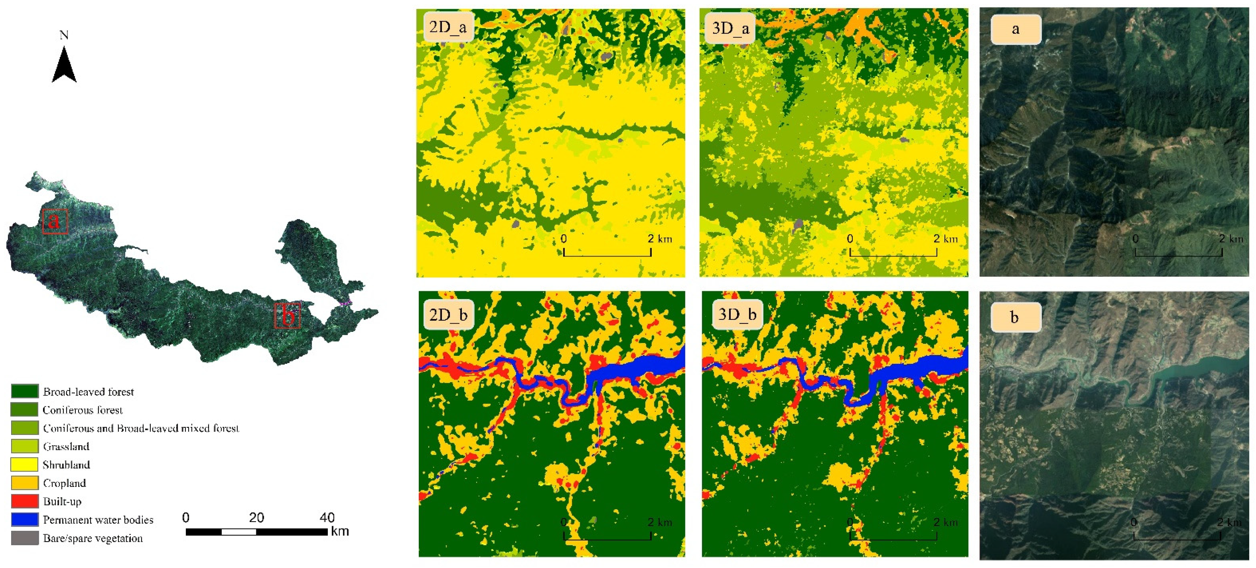
4.3. D-CNN Classification Results
4.4. Region-Specific Comparisons
4.5. Validation of the Classification Map
5. Discussion
5.1. The Effect of Characteristics Index
5.2. Performance Comparison of Four Models
6. Conclusions
Author Contributions
Funding
Institutional Review Board Statement
Informed Consent Statement
Data Availability Statement
Conflicts of Interest
References
- Liu, J.G.; Linderman, M.; Ouyang, Z.Y.; An, L.; Yang, J.; Zhang, H.M. Ecological degradation in protected areas: The case of Wolong Nature Reserve for giant pandas. Science 2001, 292, 98–101. [Google Scholar] [CrossRef] [PubMed] [Green Version]
- Myers, N.; Mittermeier, R.A.; Mittermeier, C.G.; da Fonseca, G.A.B.; Kent, J. Biodiversity hotspots for conservation priorities. Nature 2000, 403, 858. [Google Scholar] [CrossRef] [PubMed]
- Erinjery, J.J.; Singh, M.; Kent, R. Mapping and assessment of vegetation types in the tropical rainforests of the Western Ghats using multispectral Sentinel-2 and SAR Sentinel-1 satellite imagery. Remote Sens. Environ. 2018, 216, 345–354. [Google Scholar] [CrossRef]
- Laurin, G.V.; Puletti, N.; Hawthorne, W.; Liesenberg, V.; Corona, P.; Papale, D.; Chen, Q.; Valentini, R. Discrimination of tropical forest types, dominant species, and mapping of functional guilds by hyperspectral and simulated multispectral Sentinel-2 data. Remote Sens. Environ. 2016, 176, 163–176. [Google Scholar] [CrossRef] [Green Version]
- Pena-Barragan, J.M.; Ngugi, M.K.; Plant, R.E.; Six, J. Object-based crop identification using multiple vegetation indices, textural features and crop phenology. Remote Sens. Environ. 2011, 115, 1301–1316. [Google Scholar] [CrossRef]
- Wessel, M.; Brandmeier, M.; Tiede, D. Evaluation of Different Machine Learning Algorithms for Scalable Classification of Tree Types and Tree Species Based on Sentinel-2 Data. Remote Sens. 2018, 10, 1419. [Google Scholar] [CrossRef] [Green Version]
- Macintyre, P.; van Niekerk, A.; Mucina, L. Efficacy of multi-season Sentinel-2 imagery for compositional vegetation classification. Int. J. Appl. Earth Obs. 2020, 85, 101980. [Google Scholar] [CrossRef]
- Feng, Q.L.; Liu, J.T.; Gong, J.H. UAV Remote Sensing for Urban Vegetation Mapping Using Random Forest and Texture Analysis. Remote Sens. 2015, 7, 1074–1094. [Google Scholar] [CrossRef] [Green Version]
- Kattenborn, T.; Leitloff, J.; Schiefer, F.; Hinz, S. Review on Convolutional Neural Networks (CNN) in vegetation remote sensing. ISPRS J. Photogramm. 2021, 173, 24–49. [Google Scholar] [CrossRef]
- Zhang, B.; Zhao, L.; Zhang, X.L. Three-dimensional convolutional neural network model for tree species classification using airborne hyperspectral images. Remote Sens. Environ. 2020, 247, 111938. [Google Scholar] [CrossRef]
- LeCun, Y.; Boser, B.; Denker, J.S.; Henderson, D.; Howard, R.E.; Hubbard, W.; Jackel, L.D. Backpropagation Applied to Handwritten Zip Code Recognition. Neural Comput. 1989, 1, 541–551. [Google Scholar] [CrossRef]
- Krizhevsky, A.; Sutskever, I.; Hinton, G.E. ImageNet classification with deep convolutional neural networks. Commun. ACM 2017, 60, 84–90. [Google Scholar] [CrossRef]
- Simonyan, K.; Zisserman, A. Very deep convolutional networks for large-scale image recognition. arXiv 2014, arXiv:1409.1556. [Google Scholar]
- He, K.; Zhang, X.; Ren, S.; Sun, J. Deep Residual Learning for Image Recognition. In Proceedings of the 2016 IEEE Conference on Computer Vision and Pattern Recognition (CVPR), Las Vegas, NV, USA, 27–30 June 2016; pp. 770–778. [Google Scholar]
- Flood, N.; Watson, F.; Collett, L. Using a U-net convolutional neural network to map woody vegetation extent from high resolution satellite imagery across Queensland, Australia. Int. J. Appl. Earth Obs. 2019, 82, 101897. [Google Scholar] [CrossRef]
- Zhao, H.; Zhang, Y.; Liu, S.; Shi, J.; Loy, C.C.; Lin, D.; Jia, J. PSANet: Point-wise Spatial Attention Network for Scene Parsing. In Proceedings of the Computer Vision—ECCV 2018, Munich, Germany, 8–14 September 2018; pp. 270–286. [Google Scholar]
- Wambugu, N.; Chen, Y.P.; Xiao, Z.L.; Wei, M.Q. A hybrid deep convolutional neural network for accurate land cover classification. Int. J. Appl. Earth Obs. 2021, 103, 102515. [Google Scholar] [CrossRef]
- Zhang, C.; Harrison, P.A.; Pan, X.; Li, H.P.; Sargent, I.; Atkinson, P.M. Scale Sequence Joint Deep Learning (SS-JDL) for land use and land cover classification. Remote Sens. Environ. 2020, 237, 111593. [Google Scholar] [CrossRef]
- Russwurm, M.; Korner, M. Self-attention for raw optical Satellite Time Series Classification. ISPRS. J. Photogramm. 2020, 169, 421–435. [Google Scholar] [CrossRef]
- Li, Y.; Zhang, H.K.; Shen, Q. Spectral-Spatial Classification of Hyperspectral Imagery with 3D Convolutional Neural Network. Remote Sens. 2017, 9, 67. [Google Scholar] [CrossRef] [Green Version]
- Guo, M.Q.; Yu, Z.Y.; Xu, Y.Y.; Huang, Y.; Li, C.F. ME-Net: A Deep Convolutional Neural Network for Extracting Mangrove Using Sentinel-2A Data. Remote Sens. 2021, 13, 1292. [Google Scholar] [CrossRef]
- Krishnaswamy, J.; Kiran, M.C.; Ganeshaiah, K.N. Tree model based eco-climatic vegetation classification and fuzzy mapping in diverse tropical deciduous ecosystems using multi-season NDVI. Int. J. Remote Sens. 2004, 25, 1185–1205. [Google Scholar] [CrossRef]
- Geerken, R.; Zaitchik, B.; Evans, J.P. Classifying rangeland vegetation type and coverage from NDVI time series using Fourier Filtered Cycle Similarity. Int. J. Remote Sens. 2005, 26, 5535–5554. [Google Scholar] [CrossRef]
- Dorigo, W.; Lucieer, A.; Podobnikar, T.; Carni, A. Mapping invasive Fallopia japonica by combined spectral, spatial, and temporal analysis of digital orthophotos. Int. J. Appl. Earth Obs. 2012, 19, 185–195. [Google Scholar] [CrossRef]
- Defries, R.S.; Townshend, J.R.G. Ndvi-Derived Land-Cover Classifications at a Global-Scale. Int. J. Remote Sens. 1994, 15, 3567–3586. [Google Scholar] [CrossRef]
- Wood, E.M.; Pidgeon, A.M.; Radeloff, V.C.; Keuler, N.S. Image texture as a remotely sensed measure of vegetation structure. Remote Sens. Environ. 2012, 121, 516–526. [Google Scholar] [CrossRef]
- Laurin, G.V.; Liesenberg, V.; Chen, Q.; Guerriero, L.; Del Frate, F.; Bartolini, A.; Coomes, D.; Wilebore, B.; Lindsell, J.; Valentini, R. Optical and SAR sensor synergies for forest and land cover mapping in a tropical site in West Africa. Int. J. Appl. Earth Obs. 2013, 21, 7–16. [Google Scholar] [CrossRef]
- Matsushita, B.; Yang, W.; Chen, J.; Onda, Y.; Qiu, G.Y. Sensitivity of the Enhanced Vegetation Index (EVI) and Normalized Difference Vegetation Index (NDVI) to topographic effects: A case study in high-density cypress forest. Sensors 2007, 7, 2636–2651. [Google Scholar] [CrossRef] [PubMed] [Green Version]
- Qi, J.; Chehbouni, A.; Huete, A.R.; Kerr, Y.H.; Sorooshian, S. A Modified Soil Adjusted Vegetation Index. Remote Sens. Environ. 1994, 48, 119–126. [Google Scholar] [CrossRef]
- Roy, S.K.; Krishna, G.; Dubey, S.R.; Chaudhuri, B.B. HybridSN: Exploring 3-D–2-D CNN Feature Hierarchy for Hyperspectral Image Classification. IEEE Geosci. Remote Sens. Lett. 2020, 17, 277–281. [Google Scholar] [CrossRef] [Green Version]
- Makantasis, K.; Karantzalos, K.; Doulamis, A.; Doulamis, N. Deep supervised learning for hyperspectral data classification through convolutional neural networks. In Proceedings of the 2015 IEEE International Geoscience and Remote Sensing Symposium (IGARSS), Milan, Italy, 26–31 July 2015; pp. 4959–4962. [Google Scholar]
- Sun, H.; Zheng, X.T.; Lu, X.Q.; Wu, S.Y. Spectral-Spatial Attention Network for Hyperspectral Image Classification. IEEE Trans. Geosci. Remote 2020, 58, 3232–3245. [Google Scholar] [CrossRef]
- Huang, H.; Wang, J.; Sun, X.; Lu, D.; Ren, J. Evaluation priority in protection of vertical vegetation zones in Baishuijiang nature reserve. J. Lanzhou Univ. (Nat. Sci.) 2011, 47, 82–90. [Google Scholar] [CrossRef]
- Carlson, T.N.; Ripley, D.A. On the relation between NDVI, fractional vegetation cover, and leaf area index. Remote Sens. Environ. 1997, 62, 241–252. [Google Scholar] [CrossRef]
- Xu, H.Q. Modification of normalised difference water index (NDWI) to enhance open water features in remotely sensed imagery. Int. J. Remote Sens. 2006, 27, 3025–3033. [Google Scholar] [CrossRef]
- Todd, S.W.; Hoffer, R.M.; Milchunas, D.G. Biomass estimation on grazed and ungrazed rangelands using spectral indices. Int. J. Remote Sens. 1998, 19, 427–438. [Google Scholar] [CrossRef]
- Zhang, M.M.; Li, W.; Du, Q. Diverse Region-Based CNN for Hyperspectral Image Classification. IEEE Trans. Image Process 2018, 27, 2623–2634. [Google Scholar] [CrossRef]
- Tran, D.; Bourdev, L.; Fergus, R.; Torresani, L.; Paluri, M. Learning spatiotemporal features with 3d convolutional networks. In Proceedings of the IEEE International Conference on Computer Vision, Santiago, Chile, 11–18 December 2015; pp. 4489–4497. [Google Scholar]
- Fricker, G.A.; Ventura, J.D.; Wolf, J.A.; North, M.P.; Davis, F.W.; Franklin, J. A Convolutional Neural Network Classifier Identifies Tree Species in Mixed-Conifer Forest from Hyperspectral Imagery. Remote Sens. 2019, 11, 2326. [Google Scholar] [CrossRef] [Green Version]
- LeCun, Y.A.; Bottou, L.; Orr, G.B.; Müller, K.-R. Efficient BackProp. In Neural Networks: Tricks of the Trade, 2nd ed.; Montavon, G., Orr, G.B., Müller, K.-R., Eds.; Springer: Berlin/Heidelberg, Germany, 2012; pp. 9–48. [Google Scholar]
- Springenberg, J.T.; Dosovitskiy, A.; Brox, T.; Riedmiller, M. Striving for Simplicity: The All Convolutional Net. arXiv 2014, arXiv:1412.6806. [Google Scholar]
- Li, L.; Yin, J.H.; Jia, X.P.; Li, S.; Han, B.N. Joint Spatial-Spectral Attention Network for Hyperspectral Image Classification. IEEE Geosci. Remote Sens. Lett. 2021, 18, 1816–1820. [Google Scholar] [CrossRef]
- Rokni, K.; Ahmad, A.; Selamat, A.; Hazini, S. Water Feature Extraction and Change Detection Using Multitemporal Landsat Imagery. Remote Sens. 2014, 6, 4173–4189. [Google Scholar] [CrossRef] [Green Version]
- Marzialetti, F.; Di Febbraro, M.; Malavasi, M.; Giulio, S.; Acosta, A.T.R.; Carranza, M.L. Mapping Coastal Dune Landscape through Spectral Rao’s Q Temporal Diversity. Remote Sens. 2020, 12, 2315. [Google Scholar] [CrossRef]

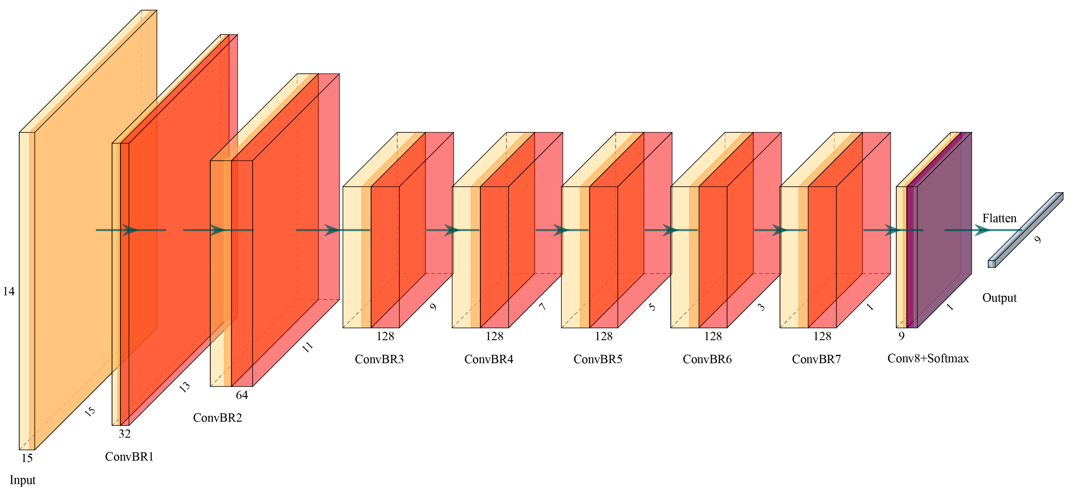

| Layer (Type) | Kernel Size | Output Shape (Height, Width, Depth, Number of Feature Map) | Number of Parameters |
|---|---|---|---|
| conv3d_1 (Conv3D) | (3, 3, 3) | (13, 13, 12, 32) | 896 |
| batch_normalization_1 | (13, 13, 12, 32) | 128 | |
| conv3d_2 (Conv3D) | (3, 3, 3) | (11, 11, 10, 64) | 55,360 |
| batch_normalization_2 | (11, 11, 10, 64) | 256 | |
| conv3d_3 (Conv3D) | (3, 3, 3) | (9, 9, 8, 128) | 221,312 |
| batch_normalization_3 | (9, 9, 8, 128) | 512 | |
| conv3d_4 (Conv3D) | (3, 3, 3) | (7, 7, 6, 128) | 442,496 |
| batch_normalization_4 | (7, 7, 6, 128) | 512 | |
| conv3d_5 (Conv3D) | (3, 3, 3) | (5, 5, 4, 128) | 442,496 |
| batch_normalization_5 | (5, 5, 4, 128) | 512 | |
| conv3d_6 (Conv3D) | (3, 3, 3) | (3, 3, 2, 128) | 442,496 |
| batch_normalization_6 | (3, 3, 2, 128) | 512 | |
| conv3d_7 (Conv3D) | (3, 3, 2) | (1, 1, 1, 128) | 295,040 |
| batch_normalization_7 | (1, 1, 1, 128) | 512 | |
| conv3d_8 (Conv3D) | (1, 1, 1) | (1, 1, 1, 9) | 1161 |
| flatten(Flatten) | (9) | 0 |
| Categories | Samples | Pixels | ||
|---|---|---|---|---|
| Training | Validation | Testing | ||
| Broad-leaved forest | 226 | 10,165 | 10,165 | 40,661 |
| Coniferous forest | 159 | 7147 | 7147 | 28,589 |
| Coniferous and broad-leaved mixed forest | 178 | 8024 | 8024 | 32,095 |
| Grassland | 90 | 3966 | 3966 | 15,865 |
| Shrubland | 74 | 3262 | 3262 | 13,049 |
| Cropland | 160 | 7166 | 7166 | 28,664 |
| Built-up | 62 | 290 | 290 | 11,157 |
| Permanent water bodies | 30 | 1289 | 1289 | 5158 |
| Bare/spare vegetation | 27 | 1166 | 1166 | 4662 |
| Total | 1006 | 44,975 | 44,975 | 179,900 |
| Algorithm | 2D-CNN (Conv = 8) | 2D-JSSAN | 2D-Resnet18 | 3D-CNN (Conv = 8) | ||||
|---|---|---|---|---|---|---|---|---|
| OI | CI | OI | CI | OI | CI | OI | CI | |
| OA(%) | 66.65 | 79.07 | 62.34 | 81.67 | 88.15 | 93.61 | 88.71 | 95.82 |
| AA(%) | 71.81 | 81.07 | 63.49 | 86.89 | 91.35 | 93.65 | 90.13 | 96.07 |
| KA(%) | 61.13 | 75.44 | 55.34 | 78.56 | 86.11 | 92.45 | 86.66 | 95.07 |
| Broad-leaved forest | 79 | 84 | 88 | 94 | 96 | 94 | 83 | 96 |
| Coniferous forest | 78 | 89 | 78 | 77 | 93 | 97 | 96 | 97 |
| Coniferous and broad-leaved mixed forest | 55 | 82 | 73 | 87 | 82 | 87 | 82 | 95 |
| Grassland | 63 | 77 | 65 | 82 | 76 | 99 | 92 | 96 |
| Shrubland | 36 | 47 | 65 | 75 | 70 | 84 | 91 | 93 |
| Cropland | 79 | 85 | 36 | 69 | 97 | 99 | 92 | 96 |
| Built-up | 73 | 80 | 98 | 92 | 89 | 91 | 92 | 95 |
| Permanent water bodies | 93 | 98 | 96 | 98 | 99 | 99 | 99 | 99 |
| Bare/spare vegetation | 52 | 79 | 98 | 98 | 96 | 97 | 96 | 99 |
| Types | Code | 1 | 2 | 3 | 4 | 5 | 6 | 7 | 8 | 9 | Recall | F-Score |
|---|---|---|---|---|---|---|---|---|---|---|---|---|
| 1. Broad-leaved forest | 1 | 39,433 | 32 | 732 | 24 | 6 | 394 | 21 | 19 | 0 | 0.97 | 0.96 |
| 2. Coniferous forest | 2 | 250 | 27,410 | 675 | 19 | 211 | 15 | 7 | 0 | 2 | 0.96 | 0.97 |
| 3. Coniferous and Broad-leaved mixed forest | 3 | 910 | 433 | 30,127 | 16 | 508 | 90 | 11 | 0 | 0 | 0.94 | 0.94 |
| 4. Grassland | 4 | 46 | 59 | 38 | 15,453 | 126 | 113 | 0 | 0 | 30 | 0.97 | 0.97 |
| 5. Shrubland | 5 | 3 | 149 | 176 | 528 | 12,056 | 136 | 0 | 0 | 1 | 0.92 | 0.93 |
| 6. Cropland | 6 | 536 | 12 | 17 | 18 | 0 | 27,609 | 464 | 8 | 0 | 0.96 | 0.96 |
| 7. Built-up | 7 | 23 | 2 | 1 | 2 | 0 | 465 | 10,630 | 17 | 17 | 0.95 | 0.95 |
| 8. Permanent water bodies | 8 | 0 | 0 | 0 | 0 | 0 | 12 | 15 | 5131 | 0 | 0.99 | 0.99 |
| 9. Bare/spare vegetation | 9 | 3 | 18 | 1 | 44 | 15 | 20 | 37 | 0 | 4524 | 0.97 | 0.98 |
| Precision | 0.96 | 0.97 | 0.95 | 0.96 | 0.93 | 0.96 | 0.95 | 0.99 | 0.99 |
| Types | Code | 1 | 2 | 3 | 4 | 5 | 6 | 7 | 8 | 9 | Recall | F-Score |
|---|---|---|---|---|---|---|---|---|---|---|---|---|
| 1. Broad-leaved forest | 1 | 97 | 0 | 2 | 0 | 0 | 0 | 0 | 0 | 0 | 0.98 | 0.98 |
| 2. Coniferous forest | 2 | 0 | 58 | 2 | 0 | 0 | 0 | 0 | 0 | 0 | 0.97 | 0.97 |
| 3. Coniferous and Broad-Leaved mixed forest | 3 | 1 | 0 | 64 | 0 | 0 | 0 | 0 | 0 | 0 | 0.98 | 0.96 |
| 4. Grassland | 4 | 0 | 0 | 0 | 34 | 1 | 3 | 0 | 0 | 1 | 0.87 | 0.89 |
| 5. Shrubland | 5 | 0 | 1 | 0 | 3 | 25 | 2 | 0 | 0 | 0 | 0.81 | 0.88 |
| 6. Cropland | 6 | 0 | 0 | 0 | 0 | 0 | 73 | 0 | 0 | 0 | 1.00 | 0.96 |
| 7. Built-up | 7 | 0 | 0 | 0 | 0 | 0 | 1 | 34 | 0 | 0 | 0.97 | 0.98 |
| 8. Permanent water bodies | 8 | 0 | 0 | 0 | 0 | 0 | 0 | 0 | 25 | 0 | 1.00 | 1.00 |
| 9. Bare/spare vegetation | 9 | 0 | 0 | 0 | 0 | 0 | 0 | 0 | 0 | 9 | 1.00 | 0.95 |
| Precision | 0.96 | 0.97 | 0.95 | 0.96 | 0.93 | 0.96 | 0.95 | 0.99 | 0.99 |
Publisher’s Note: MDPI stays neutral with regard to jurisdictional claims in published maps and institutional affiliations. |
© 2022 by the authors. Licensee MDPI, Basel, Switzerland. This article is an open access article distributed under the terms and conditions of the Creative Commons Attribution (CC BY) license (https://creativecommons.org/licenses/by/4.0/).
Share and Cite
Zhou, X.; Zhou, W.; Li, F.; Shao, Z.; Fu, X. Vegetation Type Classification Based on 3D Convolutional Neural Network Model: A Case Study of Baishuijiang National Nature Reserve. Forests 2022, 13, 906. https://doi.org/10.3390/f13060906
Zhou X, Zhou W, Li F, Shao Z, Fu X. Vegetation Type Classification Based on 3D Convolutional Neural Network Model: A Case Study of Baishuijiang National Nature Reserve. Forests. 2022; 13(6):906. https://doi.org/10.3390/f13060906
Chicago/Turabian StyleZhou, Xinyao, Wenzuo Zhou, Feng Li, Zhouling Shao, and Xiaoli Fu. 2022. "Vegetation Type Classification Based on 3D Convolutional Neural Network Model: A Case Study of Baishuijiang National Nature Reserve" Forests 13, no. 6: 906. https://doi.org/10.3390/f13060906
APA StyleZhou, X., Zhou, W., Li, F., Shao, Z., & Fu, X. (2022). Vegetation Type Classification Based on 3D Convolutional Neural Network Model: A Case Study of Baishuijiang National Nature Reserve. Forests, 13(6), 906. https://doi.org/10.3390/f13060906


