Article

Ground Cover—Biomass Functions for Early-Seral Vegetation

by
Claudio Guevara
*,
Carlos Gonzalez-Benecke
and
Maxwell Wightman
Department of Forest Engineering, Resources and Management, Oregon State University, Corvallis, OR 97330, USA
*
Author to whom correspondence should be addressed.
Forests 2021, 12(9), 1272; https://doi.org/10.3390/f12091272
Submission received: 16 July 2021 / Revised: 13 September 2021 / Accepted: 14 September 2021 / Published: 17 September 2021

Abstract

:
Vegetation biomass is commonly measured through destructive sampling, but this method is time-consuming and is not applicable for certain studies. Therefore, it is necessary to find reliable methods to estimate vegetation biomass indirectly. Quantification of early-seral vegetation biomass in reforested stands in the United States Pacific Northwest (PNW) is important as competition between the vegetation community and planted conifer seedlings can have important consequences on seedling performance. The goal of this study was to develop models to indirectly estimate early-seral vegetation biomass using vegetation cover, height, or a combination of the two for different growth habits (ferns, forbs, graminoids, brambles, and shrubs) and environments (wet and dry) in reforested timber stands in Western Oregon, USA. Six different linear and non-linear regression models were tested using cover or the product of cover and height as the only predicting variable, and two additional models tested the use of cover and height as independent variables. The models were developed for six different growth habits and two different environments. Generalized models tested the combination of all growth habits (total) and sites (pooled data set). Power models were used to estimate early-seral vegetation biomass for most of the growth habits, at both sites, and for the pooled data set. Furthermore, when power models were preferred, most of the growth habits used vegetation cover and height separately as predicting variables. Selecting generalized models for predicting early-seral vegetation biomass across different growth habits and environments is a good option and does not involve an important trade-off by losing accuracy and/or precision. The presented models offer an efficient and non-destructive method for foresters and scientists to estimate vegetation biomass from simple field or aerial measurement of cover and height. Depending on the objectives and availability of input data, users may select which model to apply.

1. Introduction

The characterization of vegetation community biomass has been widely studied for decades due to its importance in applied ecology. Vegetation biomass has been used to characterize biomes and ecosystems [1], to predict fire behavior [2], to estimate carbon stocks [3], as an indicator of ecological functioning and site productivity [4,5], for sustainable energy generation [6], for wildlife foraging supply [7,8], and as a surrogate of species richness and composition of plant communities, among other uses [9,10]. The most common method of measuring vegetation biomass in the field is through destructive sampling, but this method is time-consuming and requires multiple repetitions to accurately represent the morphological diversity within a species or a vegetation community. Destructive sampling is also not applicable for permanent plot studies, susceptible environments, or protected areas. Due to this, researchers have sought to estimate vegetation biomass with indirect techniques [10,11,12].
Current indirect methods of estimating vegetation biomass are oriented to analyze macro-scale patterns and utilize equipment, such as LiDAR [1,3,13,14] or remote-sensing techniques based on satellite images of normalized difference vegetation index (NDVI) [15,16]. Oftentimes, these methods have reduced accuracy in ecosystems with scarce vegetation, are site- and time-specific [17], and still require destructive sampling for validation. In order to develop biomass models derived from other vegetation attributes, numerous studies have found good correlations between vegetation cover and biomass for individual species [18,19,20,21], or vegetation formations such as grasslands, herbaceous layers, and shrublands [22,23,24,25].
The benefit of estimating vegetation biomass from cover is that cover measurements are easy to repeat and are, generally, well correlated to biomass [19,23,24,26,27,28,29]. Mueller-Dumbois and Ellenberg [26] found that other measures of vegetation abundance, such as density and frequency, provided a poor correlation with biomass. Estimations of vegetation biomass using vegetation cover as the only predictor variable can provide a good fit for some species and growth habits [20,29] but can produce misleading results in more complex types of ecosystems such as wetlands or stratified forests. For instance, not accounting for vegetation height can make a single-layer canopy having similar biomass to a multi-layer canopy, or shorter plants having similar biomass to taller plants for any given vegetation cover. Additionally, as some studies set a maximum vegetation cover to 100%, it is difficult to account for species overlap in highly productive ecosystems.
Axmanová et al. [27] tested multiple variables as predictors of vegetation biomass in different ecosystem types in Central Europe. In this study, the authors developed linear relationships for aboveground biomass to: (a) total cover of the herbaceous layer; (b) the sum of species cover multiplied by their heights; (c) an adjusted estimate of the latter to account for species overlap; and (d) the total cover of the herbaceous layer multiplied by the median of plant heights. Even though the cover of the herbaceous layer had a robust correlation with herbaceous biomass in all the ecosystems tested, the biomass estimate that used the median of the heights proved to have a stronger correlation. Likewise, in a study on perennial grasses in Argentina, Guevara et al. [20] used vegetation cover (in area units) and height to develop biomass functions. They concluded that models that included height as an independent variable improved model fit for some species, while other species had a better fit when vegetation cover was the only independent variable. However, these models were developed using data from only one growing season, making them susceptible to year-to-year variability, as observed by Johnson et al. [30] in a different study.
This study was carried out as part of the Competition and Site Interactions Experiment (CoSInE) conducted by the Vegetation Management Research Cooperative (VMRC) at Oregon State University. The CoSInE project is a large long-term study designed to investigate the mechanisms driving planted conifer seedling responses to forest vegetation management treatments [31]. Developing indirect methods for estimating vegetation biomass is an important component of the study as vegetation biomass is a more comprehensive measure of competing vegetation abundance than cover or height. Destructive vegetation sampling would also not be appropriate inside of the permanent plots used to monitor seedling response as such sampling would alter competition dynamics.
Different vegetation types differ in their allometric relationships and, for this reason, we separated the vegetation community into five growth habits including graminoids, forbs, ferns, brambles, and shrubs. In this study, cover, height, and biomass of early-seral vegetation were measured during two consecutive growing seasons after planting at two different sites in western Oregon, United States. The objective was to develop biomass functions of early-seral vegetation using cover or a combination of cover and height as predicting variables. Functions were developed for each vegetation growth habit and for each site. We analyzed the differences between sites for the same growth habit, aiming to have one function that works well across different sites, whenever possible.

2. Materials and Methods

2.1. Study Sites Description

Two study sites located in western Oregon were selected to represent contrasting climatic conditions of forestlands in the PNW. The coastal wet (CW) study site is located at 45°07′15″ N, 123°54′15″ W in the Coast Range near Pacific City, OR. Soils are characterized by the Tolovana-Templeton series defined as a silt loam with a water holding capacity (WHC) of 282 mm in the top 1 m of soil [32]. The elevation is about 120 m and the study area sits on a southwest-facing ridge within 6.5 km of the Pacific Ocean. The average annual rainfall is 2610 mm and the mean annual temperature is 9.9 °C [33]. Plots were installed in early September 2016, after a clear-cut harvest operation was carried out during the previous summer in August 2015. The most common species observed at the site were Digitalis purpurea, Polystichum munitum, Stachys rigida, Hypochaeris radicata, Rubus ursinus, and grasses in the Agrostis genus.
The inland dry (ID) study site is located at 43°35′35″ N, 123°08′25″ W near Yoncalla, OR. Soils are defined as silt loam from the Windygap series and have a WHC of 171 mm in the top 1 m of soil [32]. The site has an elevation of 100 m, the average annual rainfall is 1299 mm, and the mean annual temperature is 10.8 °C [33]. Plots were installed in early September 2017, after the unit was harvested in August 2017. Both study sites were established and managed by the VMRC. The most common species observed at the site were Rumex acetosella, Cirsium species, Senecio sylvaticus, Polystichum munitum, Rubus ursinus, Holcus lanatus, and grasses in the Agrostis genus.
Inter-annual climatic variation was observed across sites during the first two summers (June–August) after seedling establishment (Table 1). During 2017 and 2018 at the CW site, there were 27 and 39 rainy days, respectively, while at the ID site there were 6 and 14 rainy days during 2018 and 2019, respectively. The total rain associated with those days was 53.8 and 29.9 mm at the CW site, and 37.0 and 39.3 mm at the ID site. The average daily vapor pressure deficit (VPD) was 0.56 and 0.39 kPa at the CW site, and 1.42 and 1.28 kPa at the ID site. When averaging both years at each site, the daily maximum VPD and temperature were 0.87 kPa and 19.1 °C, respectively, at the CW site, and 2.46 kPa and 26.8 °C, respectively, at the ID site, demonstrating clear differences in growing conditions between the two sites.
Field measurements of the top 20 cm of soil determined that soil bulk density ranged from 0.298 to 0.541 g cm−3 at the CW site with an average of 0.445 g cm−3. At the ID site, bulk density ranged from 0.638 to 1.255 g cm−3 with an average of 0.984 g cm−3. Both sites had no signs of soil compaction, are rich in organic matter (coming from the harvesting operations), and have a high water holding capacity.

2.2. Study Design

At both study sites, seedlings were planted at a 3 × 3 m spacing. The CW site was planted with western hemlock using styro-10 container stock in March 2017 while the ID site was planted using bare-root Douglas-fir Plug +1 stock in January 2018. The planted location of all seedlings was previously marked using pin flags to ensure proper spacing.
The CoSInE study series includes eight unique treatments representing different combinations of pre-planting and post-planting herbicide applications during the first two growing seasons [31]. Each treatment is replicated in four blocks. The destructive sampling of vegetation within the permanent plots that receive these treatments was not considered to be appropriate and, due to this, one 18 × 18 m biomass plot was installed within each block for destructive sampling of vegetation and remained unsprayed with herbicides throughout the study. Inside each biomass plot, two 1 m2 clip plots were randomly assigned to previously numbered locations in front of a seedling every month during the growing season (April to October). In accordance with the biomass sampling method shown by Gilliam and Turrill [25], clip plots were used to destructively sample all aboveground biomass of the vegetation found inside the plot, after estimating vegetation cover (%) and height (cm) by growth habit, following the methods of Samuelson and Stokes [34]. All biomass samples were brought to the laboratory to be oven-dried at 65 °C for a minimum of 72 h until the weight remained constant. The measurements were carried out during the first two years after conifer seedling planting (2017–2018 at the CW site, and 2018–2019 at the ID site).
We identified two fern species: sword fern (clump) and bracken fern (rhizome). Due to their different morphology, the species were differentiated during the development of the biomass functions to better represent their allometric relationships. Additionally, another function was developed to estimate biomass from the vegetation of all growth habits combined (total) for each site. Total vegetation cover was calculated as the summed cover of all growth habits found inside a clip plot and could therefore exceed 100% cover. Total vegetation height was calculated as the average of the heights of all growth habits found inside a clip plot.
Biomass functions were developed for both study sites separately. A third data set was created by pooling the data from both sites to test if the same biomass function could be used across sites for any given growth habit.

2.3. Model Description

The software CurveExpert Professional version 2.6 (Hyams Development, Chattanooga, TN, USA) was used to explore compatible linear and non-linear regression models to estimate early-seral vegetation biomass depending on cover and height data. Following similar procedures to those reported in Gonzalez-Benecke et al. [5], biomass models were described, fitted, and evaluated. Six functions were selected to be tested: (1) linear, (2) power, (3) logistic, (4) logistic power, (5) shifted power, and (6) exponential association [35].
B v = a + b · x + ε i
B v = a · x b + ε i
B v = a / ( 1 + b · e x p c   ·   x ) + ε i
B v = a / ( 1 + ( x / b ) c ) + ε i
B v = a · ( x b ) c + ε i
B v = a · ( 1 e x p b ·   x ) + ε i
where B v is the biomass (Mg ha−1) for each vegetation growth habit (including total); a , b , and c are curve fit parameter estimates; e x p is the base of natural logarithm; ε i is the error term, with ε i   ~   N ( 0 ,   σ i 2 ) ; and the variable x can be either vegetation cover, or the product of cover and height (C·H, cover in percent; height in cm). Additionally, cover and height were also tested as independent variables for a modified version of equations one and two, as follows:
B v = a + b · C o v e r + c · H e i g h t + ε i
B v = a · C o v e r b · H e i g h t c + ε i
where B v is the biomass (Mg ha−1) for each vegetation growth habit (including total); a , b , and c are curve fit parameter estimates, and ε i is the error term, with ε i   ~   N ( 0 ,   σ i 2 ) .

2.4. Model Fitting and Evaluation
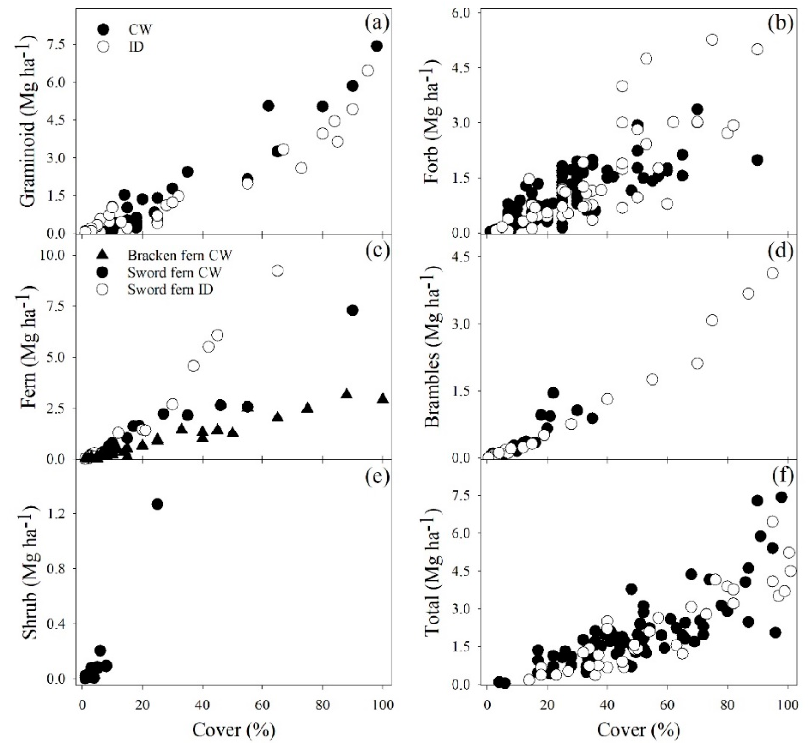
The Statistical Analysis Software version 9.4 (SAS Institute Inc. Cary, NC, USA) was used for all statistical analyses. Non-linear model fitting was conducted using the procedure PROC NLIN for all parameter estimates reported. Within each growth habit, the model with the highest coefficient of determination (R2) and the lowest Akaike information criterion (AIC) was selected. When two or more models had similar R2 and AIC, we selected the model that had a combination of good biological meaning, simplicity, and that could be used across sites and growth habits. As non-linear model fitting was carried out, an empirical R2 [36] and AIC [37] were determined as:
R 2 = 1 S S E / d f e S S T / d f t
where SSE and SST are the sum of squares of residuals and total, respectively, and dfe and dft are the degrees of freedom of error and total, respectively.
A I C = 2 · ln ( L ) + 2 · k
where L is the value of the maximum likelihood and k is the number of independently adjusted parameters.
The predictive ability of the selected models was evaluated using 10-fold cross-validation [38], splitting the data set randomly into ten subsets with an approximately equal number of observations. To evaluate the goodness-of-fit between the observed and predicted values for each growth habit, the root mean square error (RMSE) and the coefficient of variation (CV, 100∙RMSE/mean) were used. Normality and heteroskedasticity were checked using the Shapiro–Wilk and the White tests, respectively. All figures were produced using SigmaPlot version 14 (Systat Software, Inc. San Jose, CA, USA).

3. Results

Table 2 provides a summary of the sample size, mean, and range of cover (%), height (cm), and biomass (Mg ha−1) by growth habit of the samples measured at both study sites (and for the pooled data set) during the first two growing seasons after seedling conifer planting. At the ID site, no bracken fern or shrubs were found on sampled clip plots.
Mean cover, height, and biomass of sword fern did not differ across sites (p > 0.440) and averaged 18.5%, 38.4 cm, and 1.6 Mg ha−1, respectively. For forbs, the mean cover was 8.2% higher at the ID site compared to the CW site (p = 0.022). Although no significant differences were found for forb height across sites (p = 0.915), the mean forb biomass was 0.3 Mg ha−1 higher at the ID site (p = 0.031). Mean graminoid cover at the ID site was more than twice that of the CW site (30.7% vs. 14.1%, respectively, p = 0.002), while mean graminoid height did not significantly differ across sites (p = 0.083) and averaged 32.7 cm. Mean graminoid biomass at the ID site also doubled that of the CW site (1.4 vs. 0.7 Mg ha−1, p = 0.022). For brambles, mean cover and height did not significantly differ across sites (p > 0.056) but mean bramble biomass was three times higher at the ID site compared to the CW site (0.6 vs. 0.2 Mg ha−1, p = 0.022).
A comparison among growth habits and study sites for the relationships between cover and biomass is presented in Figure 1. Most growth habits had samples within the whole range of cover (0–100%), except by shrubs, which only had a maximum cover of 25% at the CW site. Graminoids and ferns had the widest ranges of biomass sampled going up to 7.4 and 9.2 Mg ha−1, respectively, while we found a maximum biomass of 5.3, 4.1, and 1.3 Mg ha−1 for forbs, brambles, and shrubs, respectively (Figure 1).

3.1. Model Selection

Goodness of fit indexes of the eight functions tested to estimate biomass for each growth habit present at the CW and ID sites, as well as for the pooled data set, are presented as Supplementary Material and are displayed in Tables S1–S3, respectively. At the CW site, five different growth habits were found: ferns, forbs, graminoids, brambles, and shrubs. When only using cover as a predictor variable, the power function (Equation (2)) provided the best estimates of biomass for all the species and growth habits except for brambles which were better estimated with the logistic function (Equation (3)). When height was included, bracken fern, graminoids, and brambles had a slight reduction in R2 and/or an increment in AIC, so the model using only cover was still preferred. Other growth habits had a considerable improvement in the estimation of biomass when including height as an independent predictor variable (Equation (8)). Such is the case of forbs and total, whose R2 increased from 0.88 to 0.92 and from 0.90 to 0.94, respectively (Table S1).
The power function using cover and height independently as the predictor variables (Equation (8)) provided a better estimation of vegetation biomass for sword fern, forbs, shrubs, and the total. Using a power function to estimate the biomass of brambles would have been ideal to keep consistency within the site, and while there was no difference in R2, the AIC decreased from −177.6 to −207.4 when using a logistic function (Equation (3)) with cover as the only predictor variable. Consequently, the logistic function was selected to estimate bramble biomass at the CW site.
At the ID site, when using cover as the only predictor variable, the power function (Equation (2)) was preferred for forbs, brambles, and the total, while the logistic function (Equation (3)) was preferred for sword fern and graminoids. No bracken fern or shrubs were found at the ID study site. When height was included as a predictor variable, the power function using both variables independently (Equation (8)) provided the best estimations of vegetation biomass for all growth habits as indicated by an increase in R2 and/or decrease in AIC. In the case of forbs and graminoids, using C∙H resulted in a slightly lower AIC, but this difference was considered negligible and the function using cover and height independently was selected to keep consistency within and across sites. The biomass of sword fern, forbs, and the total was better predicted using the same function and predicting variables as those used at the CW site. In contrast, at this site, the estimations of graminoid biomass were improved when height was included as a predictor. This is reflected in the R2, which increased from 0.96 to 0.99, and in the AIC, which decreased from −44.6 to −80.7. Similarly, at this site, bramble biomass was better estimated using a power function and including height as an independent variable (Equation (8)).
As shrubs were not present at the ID site, the pooled data set includes functions for sword fern, forbs, graminoids, and brambles and for the sum of all (total). When using only cover as a predictor variable, the power function (Equation (2)) provided the best estimations of biomass for all the growth habits. However, when height was included, the power function including both variables independently (Equation (8)) provided more accurate estimations of biomass for all growth habits, except for sword fern, which was better estimated using a logistic function (Equation (3)) with C∙H as the predicting variable. This is reflected in its improved R2 (from 0.89 to 0.93) and the decreased AIC (from −6.0 to −22.9), compared to the power function using cover and height independently as predictor variables (Equation (8)). Including height as an independent predictor variable improved the R2 of all growth habits, increasing from 0.84 to 0.91 for forbs, from 0.94 to 0.95 for graminoids, from 0.97 to 0.98 for brambles, and from 0.91 to 0.95 for total (Table S3).

3.2. Model Fitting

Parameter estimates for the selected functions to estimate biomass for each growth habit, at the CW and ID sites, as well as for the pooled data set, are reported in Table 3 when using only cover as the predictor variable, and in Table 4 when height was included. All parameter estimates were significant at p < 0.05. When using only vegetation cover as the predictor variable, the selected models to estimate early-seral vegetation biomass provided good estimations, with R2, RMSE, and CV ranging between 0.83 to 0.99, 0.04 to 0.81 Mg ha−1, and 12.8 to 56.2%, respectively (Table 3). When pooling the data sets, goodness of fit was improved, with a trend of reducing RMSE and CV. For example, for brambles, the CV of the CW and ID sites was 51.2 and 39.7%, respectively, whereas for the pooled data set the CV was 18.4%.
At the CW site, the selected functions to estimate biomass from cover and height (Table 4) provided accurate and precise estimations for early-seral vegetation of the different growth habits, with R2 values from 0.92 to 0.99, RMSE from 0.01 to 0.55 Mg ha−1, and CV from 10.8 to 56.3%. At the ID study site, the functions to estimate early-seral vegetation biomass had a better fit, with R2 ranging from 0.96 to 0.99, RMSE ranging from 0.07 to 0.55 Mg ha−1, and CV ranging from 10.7 to 25.6%. Lastly, the pooled data set showed intermediate estimations of early-seral vegetation biomass, with R2 ranging from 0.91 to 0.98, RMSE from 0.12 to 0.71 Mg ha−1, and CV ranging from 28.9 to 44.9%.
Focusing on each growth habit, it is worth noticing that only sword fern, forbs, graminoids, and total used the same type of function (power; Equation (8)) and predictor variables (cover and height, independently) to estimate biomass at each site. However, when both sites were pooled, sword fern biomass was better predicted using a logistic function (Equation (3)) and C∙H as the predictor variable. Brambles used different predicting variables and even different functions across sites.
The values of the parameter estimates of height were generally smaller than the parameter estimates of cover, indicating that the estimations of biomass are mostly explained by the changes in vegetation cover. For example, the ratio of the parameter estimate of cover to the parameter estimate of height ( b : c ) for sword fern was 1.78 and 3.52 for the CW and the ID study sites, respectively. Similarly, for the total, the b : c ratio was 3.94 and 5.80 for the CW and ID sites, respectively. Only shrubs at the CW site and forbs and graminoids at the ID site had a b : c ratio close to 1.

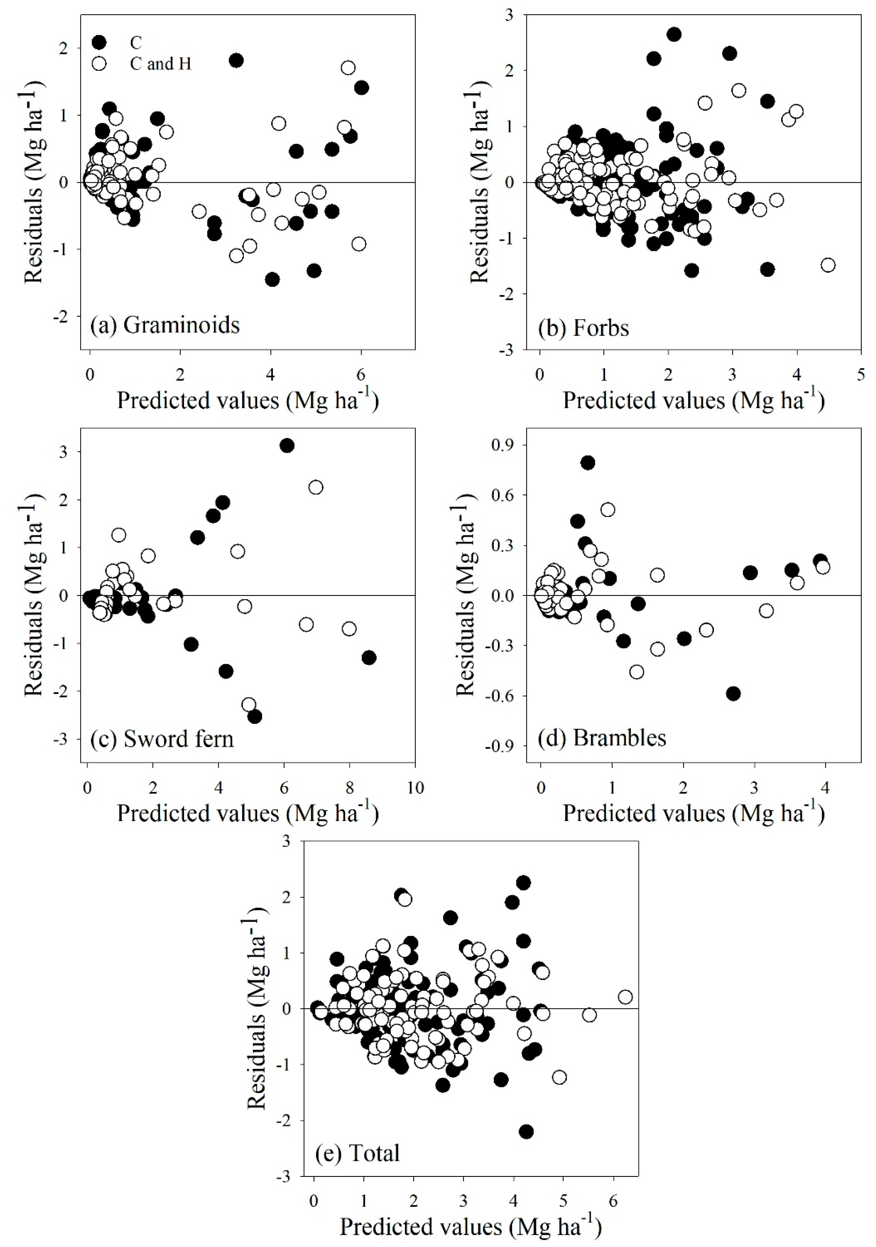
3.3. Model Evaluation

Figure 2 shows the graphical evaluation of the vegetation biomass functions selected when using cover (from Table 3) or cover and height (from Table 4) for each growth habit for the pooled data set and shows no signs of heteroscedasticity. For a clearer display of the results, each graph has its own X and Y scales, and the Y-axis (residuals) was centered around zero (0). Residuals from the functions that use cover and height (open circles) showed a reduced variability compared to those from functions using only cover (filled circles), as the values are closer to zero (Figure 2).
A summary of the model performance test using 10-fold cross-validation for the selected models is shown in Table 5. There was a good agreement between observed and predicted values of vegetation biomass for all growth habits across sites. Across growth habits and sites, the bias ranged between a 3.9% underestimation to a 5.4% overestimation when using cover as the only predicting variable, and from a 2.6% underestimation to a 3.7% overestimation when using cover and height (combined or as independent variables).

4. Discussion

The vegetation community was never treated with any type of vegetation control and, therefore, the sampled vegetation community is representative of the native plant community on seral sites in the PNW. The functions to estimate biomass of early-seral vegetation (classified as ferns, forbs, graminoids, brambles, and shrubs) presented in this study offer a valuable tool for the study and management of these types of vegetation, and could be applicable to any early-seral environment in the region after natural or artificial disturbances, providing a useful tool to researchers and natural resources managers. In an effort to simplify models, general functions combining different growth habits within a site, different sites within a growth habit, and a broader function that can be used across sites and growth habits were presented. Depending on the focus of the study or management project, the environmental conditions, the availability of input data, and the level of accuracy desired, users may select which model to use.
Power functions were used to estimate early-seral vegetation biomass in most cases, at both sites, and for the combined data set. Only brambles at the CW site, sword fern and graminoids at the ID site, and sword fern when both sites were combined used a different model equation to estimate biomass (logistic in all cases). Furthermore, when power functions were preferred, most of the growth habits used cover and height separately as predicting variables. Only bracken fern and graminoids at the CW site and graminoids and brambles for the pooled data set had slightly higher precision when using cover as the only predictor. Power functions were utilized in previous studies to estimate biomass of similar types of vegetation using diameter [39,40], diameter and height [41], or cover [25,42] as predicting variables.
Similar to what we found, in a study on temperate deciduous forests across Northwest Europe, Landuyt et al. [42] used a model based on power functions with vegetation cover and shoot length as independent predictor variables to estimate biomass. On the other hand, Paul et al. [39] found little improvement when other variables (height, wood density) or site characteristics (weather, stand age, management) were included in a study on managed and natural ecosystems across Australia.
Gilliam and Turrill [25] analyzed the relationship between cover and biomass of herbaceous species from the Appalachian hardwood forest in West Virginia, U.S. They developed a power equation that utilized data from all species combined (not by growth habit) to estimate the biomass of individual species that had above 10% cover. For better biomass estimates when species had a low cover (<10%), linear regression for mean herb biomass within each 1–10% cover class was developed. Both equations only included cover as a predicting variable. Ferrari [28] also found linear relationships between vegetation cover and biomass in a study conducted in the understory of longleaf pine stands in Georgia, U.S. This was the only study that worked at a growth habit level, but the nature of their functions and the different environments make the results hard to compare. We could not find studies working on this topic at a growth habit level in the PNW. Therefore, it is difficult to compare our results to other studies in this region.
One of the advantages of using cover and height as independent predictor variables is that vegetation biomass on multi-layered vegetation communities can be better estimated. Another advantage is that this allows the height to have a different weight than the cover, which does not happen when using the product of cover and height (C∙H). Cover and height were used independently in 13 of the power functions that we developed. In ten of them, the b:c ratio ranged from 1.78 to 5.80, indicating that cover is more closely related to biomass than height. In the three remaining functions, the b:c ratio ranged between 0.94 and 1.11, indicating a more balanced distribution of cover and height on vegetation biomass prediction. The disadvantage of using two predictor variables is that more data are needed as input for the biomass equations, thus making it difficult to apply when using cover data obtained from indirect methods, such as satellite images, for instance.
When comparing the goodness of fit of the selected functions using only cover (Table 3) with the functions that use cover and height (Table 4), we found that including height (as an independent variable or multiplied with cover) improved biomass estimations in almost all the cases and reduced the bias (Table 5). However, in the case of bracken fern, graminoids, and brambles at the CW site; sword fern at the ID site; and sword fern, graminoids, and brambles for the pooled data set, including height, slightly reduced the R2 or increased the RMSE or the CV.
In our study, when using cover and height as predicting variables, the functions obtained using the pooled data set had an R2 ranging between 0.91 and 0.98 for the different growth habits. Additionally, when all growth habits were combined at each study site, the developed functions had high coefficients of determination with R2 values of 0.94, 0.96, and 0.95 for the CW, ID, and pooled data set, respectively. Paul et al. [39] found less than 1% of prediction efficiency was lost when generalized models were used instead of species-specific models. Gilliam and Turrill [25] did not find significant differences in the parameters of site-specific biomass equations when compared to those that tested the sites together. Goldberg [43] wondered whether models could be general enough to be useful over a range of sites and species but specific enough to be useful for making quantitative management recommendations. The results of this study, Paul et al. [39], and Gilliam and Turrill [25] demonstrate that this is possible. Selecting generalized models is a good option for predicting vegetation biomass and does not involve an important trade-off by losing too much precision.
The data utilized to develop our functions were gathered from sites with contrasting climatic conditions (Table 1) and during three different years (2017, 2018, and 2019). Our data include inter-annual climatic variability and its effect on early-seral vegetation biomass allometry, making it useful for different sites and climate conditions within the region.
Indirect methods to analyze macro-scale patterns of vegetation cover can be measured using equipment, such as LiDAR or remote-sensing techniques based on NDVI satellite images. Our functions have the potential of estimating early-seral vegetation biomass based on these cover measurements without the need for destructive sampling. Additionally, as vegetation cover and biomass are correlated to leaf area index, our functions could be used in ecological assessments of stand productivity, inter-specific competition dynamics, and water and nutrient use, among other potential applications.

5. Conclusions

Assessing vegetation cover and height in the field is an efficient and non-destructive method to estimate vegetation biomass that can be easily applied by natural resources professionals, forest managers, and scientists. Biomass estimations are essential for the analysis of ecosystem carbon storage, water use, fire load accumulation, sustainable energy generation, wildlife habitat, forage supply, among other ecosystem attributes of interest. The relationship of cover and biomass varies among vegetation growth habits due to differences in morphology, biomass distribution, and carbon content, but it is comparable within species of the same growth habit. Functions to estimate biomass using cover, height, or the combination of the two were developed for different vegetation growth habits (ferns, forbs, graminoids, brambles, and shrubs) and different environments (wet and dry). Generalized models combining all the growth habits and across different environments were also developed and showed acceptable predicting power. The functions presented in this study were developed for early-seral species classified in different growth habits during the first two growing seasons on two recently planted sites in the PNW. Applying our models out of this region, on non-disturbed sites, or for other age classes should be done with caution.

Supplementary Materials

The following are available online at https://www.mdpi.com/article/10.3390/f12091272/s1, Table S1. Goodness of fit of the functions tested to estimate biomass for each growth habit of early-seral vegetation growing at a costal wet (CW) site in western Oregon. Table S2. Goodness of fit of the functions tested to estimate biomass for each growth habit of early-seral vegetation growing at a dry inland (ID) site in western Oregon. Table S3. Goodness of fit of the functions tested to estimate biomass for each growth habit of early-seral vegetation for the pooled data set.

Author Contributions

Conceptualization, C.G.-B. and M.W.; Methodology, C.G., C.G.-B. and M.W.; Formal analysis, C.G. and C.G.-B.; Investigation, C.G.; Writing—original draft preparation, C.G.; Writing—review and editing, C.G.-B. and M.W.; All authors have read and agreed to the published version of the manuscript.

Funding

This research was supported by the Department of Forest Engineering, Resources, and Management, The Graduate School, and the Vegetation Management Research Cooperative at Oregon State University.

Data Availability Statement

Data may be shared upon request to the corresponding author.

Acknowledgments

This research was conducted by the Vegetation Management Research Cooperative at Oregon State University. The authors are grateful for the support received from all individuals who contributed to collecting the data used in this study.

Conflicts of Interest

The authors declare no conflict of interest.

References

  1. Ji, L.; Wylie, B.K.; Nossov, D.R.; Peterson, B.; Waldrop, M.P.; McFarland, J.W.; Rover, J.; Hollingsworth, T.N. Estimating aboveground biomass in interior Alaska with Landsat data and field measurements. Int. J. Appl. Earth Obs. Geoinf. 2012, 18, 451–461. [Google Scholar] [CrossRef]
  2. Gonzalez-Benecke, C.; Samuelson, L.; Stokes, T.; Cropper, W.; Martin, T.; Johnsen, K. Understory plant biomass dynamics of prescribed burned Pinus palustris stands. For. Ecol. Manag. 2015, 344, 84–94. [Google Scholar] [CrossRef]
  3. García, M.; Riaño, D.; Chuvieco, E.; Danson, F. Estimating biomass carbon stocks for a Mediterranean forest in central Spain using LiDAR height and intensity data. Remote Sens. Environ. 2010, 114, 816–830. [Google Scholar] [CrossRef]
  4. Eisfelder, C.; Klein, I.; Bekkuliyeva, A.; Kuenzer, C.; Buchroithner, M.F.; Dech, S. Above-ground biomass estimation based on NPP time-series—A novel approach for biomass estimation in semi-arid Kazakhstan. Ecol. Indic. 2017, 72, 13–22. [Google Scholar] [CrossRef]
  5. Gonzalez-Benecke, C.A.; Gezan, S.A.; Albaugh, T.J.; Allen, H.; Burkhart, H.E.; Fox, T.R.; Jokela, E.J.; Maier, C.A.; Martin, T.A.; Rubilar, R.; et al. Local and general above-stump biomass functions for loblolly pine and slash pine trees. For. Ecol. Manag. 2014, 334, 254–276. [Google Scholar] [CrossRef]
  6. Yan, P.; Xiao, C.; Xu, L.; Yu, G.; Li, A.; Piao, S.; He, N. Biomass EeTerrestrial Eco-systems: Insights into the Nation’s Sustainable Energy Supply. Renew. Sustain. Energy Rev. 2020, 127, 1–10. [Google Scholar] [CrossRef]
  7. Garroutte, E.L.; Hansen, A.J.; Lawrence, R.L. Using NDVI and EVI to Map Spa-tiotemporal Variation in the Biomass and Quality of Forage for Migratory Elk in the Greater Yellowstone Ecosystem. Remote Sens. 2016, 8, 404. [Google Scholar]
  8. Moreau, S.; Toan, T.L. Biomass quantification of Andean wetland Forages Using ERS Satellite SAR Data for Optimizing Livestock Management. Remote Sens. Environ. 2003, 84, 477–492. [Google Scholar] [CrossRef]
  9. Grime, J.P. Plant Strategies and Vegetation Processes; John Wiley and Sons: Chichester, UK, 1979. [Google Scholar]
  10. Catchpole, W.R.; Wheeler, C.J. Estimating plant biomass: A review of techniques. Austral Ecol. 1992, 17, 121–131. [Google Scholar] [CrossRef]
  11. Jonasson, S. Evaluation of the Point Intercept Method for the Estimation of Plant Biomass. Oikos 1988, 52, 101. [Google Scholar] [CrossRef]
  12. Somogyi, Z.; Cienciala, E.; Mäkipää, R.; Muukkonen, P.; Lehtonen, A.; Weiss, P. Indirect methods of large-scale forest biomass estimation. Eur. J. For. Res. 2006, 126, 197–207. [Google Scholar] [CrossRef]
  13. Dubayah, R.O.; Sheldon, S.L.; Clark, D.B.; Hofton, M.A.; Blair, J.B.; Hurtt, G.C.; Chazdon, R. Estimation of tropical forest height and biomass dynamics using lidar remote sensing at La Selva, Costa Rica. J. Geophys. Res. Space Phys. 2010, 115. [Google Scholar] [CrossRef]
  14. Kronseder, K.; Ballhorn, U.; Böhm, V.; Siegert, F. Above ground biomass estimation across forest types at different degradation levels in Central Kalimantan using LiDAR data. Int. J. Appl. Earth Obs. Geoinf. 2012, 18, 37–48. [Google Scholar] [CrossRef]
  15. Thenkabail, P.S.; Stucky, N.; Griscom, B.W.; Ashton, M.S.; Diels, J.; Van Der Meer, B.; Enclona, E. Biomass estimations and carbon stock calculations in the oil palm plantations of African derived savannas using IKONOS data. Int. J. Remote Sens. 2004, 25, 5447–5472. [Google Scholar] [CrossRef]
  16. Bendig, J.; Yu, K.; Aasen, H.; Bolten, A.; Bennertz, S.; Broscheit, J.; Gnyp, M.L.; Bareth, G. Combining UAV-based plant height from crop surface models, visible, and near infrared vegetation indices for biomass monitoring in barley. Int. J. Appl. Earth Obs. Geoinf. 2015, 39, 79–87. [Google Scholar] [CrossRef]
  17. Eisfelder, C.; Kuenzer, C.; Dech, S. Derivation of biomass information for semi-arid areas using remote-sensing data. Int. J. Remote Sens. 2011, 33, 2937–2984. [Google Scholar] [CrossRef]
  18. Yarie, J. The Role of Understory Vegetation in the Nutrient Cycle of Forest-ed Ecosystems in the Mountain Hemlock Biogeoclimatic Zone. Ecology 1980, 61, 1498–1514. [Google Scholar] [CrossRef] [Green Version]
  19. Rottgermann, M.; Steinlein, T.; Beyschlag, W.; Dietz, H. Linear relationships between aboveground biomass and plant cover in low open herbaceous vegetation. J. Veg. Sci. 2000, 11, 145–148. [Google Scholar] [CrossRef]
  20. Guevara, J.; Gonnet, J.; Estevez, O. Biomass estimation for native perennial grasses in the plain of Mendoza, Argentina. J. Arid. Environ. 2002, 50, 613–619. [Google Scholar] [CrossRef]
  21. Heinrichs, S.; Bernhardt-Römermann, M.; Schmidt, W. The estimation of aboveground biomass and nutrient pools of understorey plants in closed Norway spruce forests and on clearcuts. Eur. J. For. Res. 2010, 129, 613–624. [Google Scholar] [CrossRef] [Green Version]
  22. Hermy, M. Accuracy of Visual Cover Assessments in Predicting Standing Crop and Environmental Correlation in Deciduous Forests. Vegetatio 1988, 75, 57–64. [Google Scholar] [CrossRef]
  23. Chiarucci, A.; Wilson, J.B.; Anderson, B.J.; De Dominicis, V. Cover versus biomass as an estimate of species abundance: Does it make a difference to the conclusions? J. Veg. Sci. 1999, 10, 35–42. [Google Scholar] [CrossRef]
  24. Muukkonen, P.; Mäkipää, R.; Laiho, R.; Minkkinen, K.; Vasander, H.; Finér, L. Relationship between Biomass and Percentage Cover in Understorey Vegeta-tion of Boreal Coniferous Forests. Silva Fenn. 2006, 40, 231–245. [Google Scholar] [CrossRef] [Green Version]
  25. Gilliam, F.S.; Turrill, N.L. Herbaceous Layer Cover and Biomass in a Young Versus a Mature Stand of a Central Appalachian Hardwood Forest. Bull. Torrey Bot. Club 1993, 120, 445. [Google Scholar] [CrossRef]
  26. Mueller-Dombois, D.; Ellenberg, H. Aims and Methods of Vegetation Ecology; John Wiley and Sons: New York, NY, USA, 1974. [Google Scholar]
  27. Axmanová, I.; Tichý, L.; Fajmonová, Z.; Hájková, P.; Hettenbergerová, E.; Li, C.-F.; Merunková, K.; Nejezchlebová, M.; Otýpková, Z.; Vymazalová, M.; et al. Estimation of herbaceous biomass from species composition and cover. Appl. Veg. Sci. 2012, 15, 580–589. [Google Scholar] [CrossRef]
  28. Ferrari, L. Relationships between Plant Biomass and Cover in the Ground Cover Layer of Longleaf Pine Forests at Fort Benning, GA. Master’s Thesis, Auburn University, Auburn, AL, USA, 14 December 2013. [Google Scholar]
  29. Flombaum, P.; Sala, O. A non-destructive and rapid method to estimate biomass and aboveground net primary production in arid environments. J. Arid. Environ. 2007, 69, 352–358. [Google Scholar] [CrossRef]
  30. Johnson, P.S.; Johnson, C.L.; West, N.E. Estimation of Phytomass for Ungrazed Crested Wheatgrass Plants Using Allometric Equations. J. Range Manag. 1988, 41, 421. [Google Scholar] [CrossRef]
  31. Guevara, C.A.; Gonzalez-Benecke, C.A.; Wightman, M.G. Competition and Site Interactions Experiment Tier I.; Western Hemlock and Douglas-Fir (Vegeta-tion Dynamics, Soil Moisture, Seedling Growth, and Survival). Veg. Manag. Res. Coop. Annu. Rep. 2019, 1–21. [Google Scholar]
  32. Web Soil Survey, Soil Survey Staff. Web Soil Survey: Soil Data Mart. USDA-NCRS. Available online: https://websoilsurvey.sc.egov.usda.gov/ (accessed on 20 October 2018).
  33. Wang, T.; Hamann, A.; Spittlehouse, D.L.; Murdock, T.Q. ClimateWNA—High-Resolution Spatial Climate Data for Western North America. J. Appl. Meteorol. Clim. 2012, 51, 16–29. [Google Scholar] [CrossRef] [Green Version]
  34. Samuelson, L.J.; Stokes, T.A. Developing Tools for Ecological Forestry and Carbon Management in Longleaf Pine. In Field Methods and Protocols; Auburn University: Auburn, AL, USA, 2011. [Google Scholar]
  35. Seber, G.A.; Wild, C.J. Nonlinear Regression; Wiley: Hoboken, NJ, USA, 2003. [Google Scholar]
  36. Myers, R.H. Classical and Modern Regression with Applications, 2nd ed.; Duxbury: Pacific Grove, CA, USA, 2000. [Google Scholar]
  37. Akaike, H. A new look at the statistical model identification. IEEE Trans. Autom. Control 1974, 19, 716–723. [Google Scholar] [CrossRef]
  38. Neter, J.; Kutner, M.H.; Nachtsheim, C.J.; Wasserman, W. Applied Linear Statistical Models, 4th ed.; Irwin: Toronto, ON, Canada, 1996. [Google Scholar]
  39. Paul, K.I.; Roxburgh, S.H.; Chave, J.; England, J.; Zerihun, A.; Specht, A.; Lewis, T.; Bennett, L.; Baker, T.G.; Adams, M.; et al. Testing the generality of above-ground biomass allometry across plant functional types at the continent scale. Glob. Chang. Biol. 2016, 22, 2106–2124. [Google Scholar] [CrossRef] [PubMed]
  40. Paul, K.I.; Larmour, J.; Specht, A.; Zerihun, A.; Ritson, P.; Roxburgh, S.H.; Sochacki, S.; Lewis, T.; Barton, C.V.; England, J.R.; et al. Testing the generality of below-ground biomass allometry across plant functional types. For. Ecol. Manag. 2018, 432, 102–114. [Google Scholar] [CrossRef]
  41. Blujdea, V.; Pilli, R.; Dutca, I.; Ciuvat, L.; Abrudan, I. Allometric biomass equations for young broadleaved trees in plantations in Romania. For. Ecol. Manag. 2012, 264, 172–184. [Google Scholar] [CrossRef]
  42. Landuyt, D.; Maes, S.L.; Depauw, L.; Ampoorter, E.; Blondeel, H.; Perring, M.; Brūmelis, G.; Brunet, J.; Decocq, G.; Ouden, J.D.; et al. Drivers of above-ground understorey biomass and nutrient stocks in temperate deciduous forests. J. Ecol. 2019, 108, 982–997. [Google Scholar] [CrossRef]
  43. Goldberg, D.E. Simplifying the Study of Competition at the Individual Plant Level: Consequences of Distinguishing between Competitive Effect and Response for Forest Vegetation Management. N. Z. J. For. Sci. 1996, 26, 19–38. [Google Scholar]
Figure 1. Relationship between cover (%) and biomass (Mg ha−1) for (a) graminoids, (b) forbs, (c) ferns, (d) brambles, (e) shrubs, and (f) total for early-seral vegetation growing at the coastal wet (CW, filled circle) and inland dry (ID, open circle) sites in western Oregon. The fern graph (c) includes bracken fern found at the CW site (filled triangle) and the shrub graph (e) does not include data from the ID site due to a lack of samples found.
Forests 12 01272 g001
Figure 2. Evaluation of the biomass functions selected for (a) graminoids, (b) forbs, (c) ferns, (d) brambles, and (e) the sum of all growth habits (total) when using only cover (C, filled circle) or cover and height (C and H, open circle) for the pooled data set.
Forests 12 01272 g002
Table 1. Number of days with rainfall (Rainy days), total rainfall, mean daily maximum temperature (T max), mean daily temperature (T mean), mean daily daylight hour relative humidity (RH), mean daily maximum vapor pressure deficit (VPD max), and mean daily daylight hour vapor pressure deficit (VPD mean) for the first two summers (June–August) at the coastal wet (CW) and inland dry (ID) sites in western Oregon.
CWID
2017201820182019
Rainy days2739614
Total Rain (mm)53.829.937.039.3
T max (°C)19.119.127.226.3
T mean (°C)14.614.618.418.2
RH (%)74.781.154.857.3
VPD max (kPa)0.950.802.602.31
VPD mean (kPa)0.560.391.421.28
Table 2. Summary statistics of cover, height, and biomass measured by growth habit for the coastal wet (CW) and inland dry (ID) sites in western Oregon. Data from both sites were combined to create a pooled data set.
SiteVegetation TypeCover (%)Height (cm)Biomass (Mg ha−1)
nMeanMinMaxnMeanMinMaxMeanMinMax
CWBracken fern3226.811001949.6121000.80.013.1
Sword fern1820.42901839.320721.40.047.3
Forbs9027.41906532.551501.10.033.4
Graminoids7614.11985428.851480.70.0027.4
Brambles477.41353617.94600.20.0011.5
Shrubs184.61251623.19500.10.0021.3
IDSword fern1916.71651937.65681.80.019.2
Forbs4735.63904728.65801.40.045.3
Graminoids2930.71952939.97861.40.026.5
Brambles3018.21953021.55500.60.0014.1
PooledSword fern3718.51903738.45721.60.019.2
Forbs13730.219011230.951501.20.035.3
Graminoids10518.71988332.751480.90.0027.4
Brambles7711.61956619.54600.40.0014.1
The sample size for biomass is the same sample size of cover.
Table 3. Parameter estimates and fit statistics of the selected functions to estimate biomass using cover for each growth habit of early-seral vegetation growing in Western Oregon.
SiteGrowth HabitModelParameterParameter EstimateSER2RMSECV
CWBracken fern = a · C o v e r b a0.0303510.0074260.9720.2124.4
b1.0166270.058688
Sword fern = a · C o v e r b a0.0394990.0171280.9580.4432.3
b1.1398700.104380
Forbs = a · C o v e r b a0.0931370.0250810.8810.4441.4
b0.7511690.072756
Graminoids = a · C o v e r b a0.0132340.0032930.9540.3348.3
b1.3661240.057796
Brambles = a 1 + b · e x p c   ·   C o v e r a1.0956290.0660660.9240.1151.2
b70.70985530.877161
c0.2851860.032782
Shrubs = a · C o v e r b a0.0030510.0012360.9830.0435.0
b1.8724080.127451
Total = a · C o v e r b a0.0240050.0120960.8960.7037.5
b1.1196840.121707
IDSword fern = a 1 + b · e x p c   ·   C o v e r a9.9656880.3736410.9940.2312.8
b45.2797746.867032
c0.0961930.005173
Forbs = a · C o v e r b a0.0400840.0128630.8380.6252.0
b0.9960120.082203
Graminoids = a 1 + b · e x p c   ·   C o v e r a663,843,1667.28 × 10120.9720.3826.2
b1,932,462,1722.12 × 1013
c0.0300930.001911
Brambles = a · C o v e r b a0.0151680.0027120.9710.1539.7
b1.2200710.042044
Total = a · C o v e r b a0.0124020.0049270.9080.7036.2
b1.2790810.093410
PooledSword fern = a · C o v e r b a0.0233190.0055010.9920.2915.8
b1.4407940.060425
Forbs = a · C o v e r b a0.0147290.0105940.8290.8156.2
b1.2663690.175836
Graminoids = a · C o v e r b a0.0056390.0046920.9600.4531.2
b1.5021710.189706
Brambles = a · C o v e r b a0.0059660.0017280.9920.1118.4
b1.4320980.066262
Total = a · C o v e r b a0.0045440.0033000.9310.7032.6
b1.5094320.164803
CW: coastal wet site; ID: inland dry site; Pooled: pooled data set combining both sites; Cover: vegetation ground cover (%); Height: vegetation height (cm); SE: standard error; R2: coefficient of determination; RMSE: root mean square error (Mg ha−1); CV: coefficient of variation (%). For all parameter estimates p < 0.05.
Table 4. Parameter estimates and fit statistics of the selected functions to estimate biomass from cover and height for each growth habit of early-seral vegetation growing in Western Oregon.
SiteGrowth HabitModelParameterParameter EstimateSER2RMSECV
CWBracken fern = a · C o v e r b · H e i g h t c a0.0507650.0308710.9710.2631.0
b1.1417090.140055
c−0.2501870.202383
Sword fern = a · C o v e r b · H e i g h t c a0.0134920.0056560.9790.3223.1
b0.9074550.078963
c0.5112140.137416
Forb = a · C o v e r b · H e i g h t c a0.0438410.0127410.9200.3633.8
b0.7656300.073362
c0.2249450.050597
Graminoid = a · C o v e r b · H e i g h t c a0.0122400.0039730.9450.3856.3
b1.2998040.095254
c0.0858440.07546
Bramble = a 1 + b · e x p c   ·   C · H a1.1322710.0786350.9230.1233.0
b15.1100964.215749
c0.5204230.07042
Shrub = a · C o v e r b · H e i g h t c a0.0001208870.0000456290.9940.0110.8
b1.2554750.038010
c1.3332920.111233
Total = a · C o v e r b · H e i g h t c a0.0296620.0124570.9410.5529.3
b0.9495640.110260
c0.2410960.054032
IDSword fern = a · C o v e r b · H e i g h t c a0.0046890.0021910.9930.2111.7
b1.4363810.048306
c0.4079660.105510
Forb = a · C o v e r b · H e i g h t c a0.0014690.0006150.9710.3423.2
b1.0219330.076051
c0.9184080.072488
Graminoid = a · C o v e r b · H e i g h t c a0.0018490.0007620.9890.2416.5
b0.9067810.064931
c0.9198630.107180
Bramble = a · C o v e r b · H e i g h t c a0.0026230.0005390.9940.0710.7
b1.2783910.038965
c0.4008630.054239
Total = a · C o v e r b · H e i g h t c a0.0061480.0033140.9580.5525.6
b1.3071600.129175
c0.2251790.045990
PooledSword fern = a 1 + b · e x p c   ·   C · H a7.9904140.5888400.9320.7144.0
b20.5319895.062166
c0.1519180.015650
Forb = a · C o v e r b · H e i g h t c a0.0113220.0035210.9110.4839.8
b0.9586100.067395
c0.4182760.049445
Graminoid = a · C o v e r b · H e i g h t c a0.0082940.0026810.9540.4044.9
b1.0988200.075305
c0.3523460.057777
Bramble = a · C o v e r b · H e i g h t c a0.0042850.0012500.9820.1233.5
b1.0820310.038280
c0.4996400.081455
Total = a · C o v e r b · H e i g h t c a0.0165820.0053200.9460.5628.9
b1.0890330.081624
c0.2257140.035750
CW: coastal wet site; ID: inland dry site; Pooled: pooled data set combining both sites; Cover: vegetation ground cover (%); Height: vegetation height (cm); C∙H: product of cover and height; SE: standard error; R2: coefficient of determination; RMSE: root mean square error (Mg ha−1); CV: coefficient of variation (%). For all parameter estimates p < 0.05.
Table 5. Summary of model evaluation statistics using 10-fold cross-validation for biomass estimations for each growth habit of early-seral vegetation growing in Western Oregon.
SiteGrowth HabitModelExplanatory Variable (s) O ¯ P ¯ RMSE Bias
CWBracken fern = a · X b Cover0.850.870.15(17.3)−0.02(−1.9)
Cover and Height1.171.180.21(18.1)−0.01(−0.9)
Sword fern = a · X b Cover1.371.330.34(24.9)0.05(3.4)
Cover and Height1.371.380.26(18.9)−0.01(−0.6)
Forbs = a · X b Cover1.071.070.42(39.0)−0.01(−0.7)
Cover and Height1.051.050.33(31.8)0.00(0.0)
Graminoids = a · X b Cover0.680.670.25(36.5)0.01(1.4)
Cover and Height0.830.810.27(32.1)0.02(2.7)
Brambles = a 1 + b · e x p c   ·   X Cover0.210.200.28(133.5)0.00(2.1)
C∙H0.250.260.11(44.5)0.00(−1.5)
Shrubs = a · X b Cover0.110.110.03(23.8)0.01(5.4)
Cover and Height0.130.120.01(7.5)0.00(2.9)
Total = a · X b Cover1.861.850.66(35.3)0.01(0.5)
Cover and Height1.981.980.46(23.3)0.00(0.2)
IDSword fern = a 1 + b · e x p c   ·   X Cover1.821.871.34(73.5)−0.05(−2.6)
= a · X b Cover and Height1.821.810.15(8.0)0.01(0.7)
Forbs = a · X b Cover1.451.440.78(53.6)0.00(0.3)
Cover and Height1.451.410.31(21.4)0.04(2.7)
Graminoids = a 1 + b · e x p c   ·   X Cover1.441.450.32(22.2)−0.02(−1.3)
= a · X b Cover and Height1.441.400.21(14.3)0.04(2.8)
Brambles = a · X b Cover0.630.610.09(14.2)0.01(2.4)
Cover and Height0.630.610.05(8.6)0.01(1.8)
Total = a · X b Cover2.142.140.58(27.2)0.00(0.1)
Cover and Height2.142.151.37(63.8)−0.01(−0.5)
PooledSword fern = a · X b Cover1.601.670.73(45.2)−0.06(−3.9)
= a 1 + b · e x p c   ·   X C∙H1.601.650.54(33.7)−0.04(−2.6)
Forbs = a · X b Cover1.201.190.58(48.5)0.00(0.3)
Cover and Height1.221.200.45(37.2)0.02(1.5)
Graminoids = a · X b Cover0.890.850.39(43.9)0.04(4.1)
Cover and Height1.041.000.35(33.6)0.04(3.7)
Brambles = a · X b Cover0.370.370.10(27.0)0.00(−0.8)
Cover and Height0.420.420.10(23.8)0.00(1.0)
Total = a · X b Cover1.951.940.67(34.4)0.01(0.7)
Cover and Height2.042.041.12(54.9)0.00(0.1)
CW: coastal wet site; ID: inland dry site; Pooled: pooled data set combining both sites; Cover: vegetation ground cover (%); Height: vegetation height (cm); C∙H: product of cover and height; O ¯ : mean observed value; P ¯ : mean predicted value; RMSE: root of mean square error (same unit as observed value); Bias: mean absolute bias (predicted-observed; same unit as observed value). Values in parenthesis are percentages relative to the observed mean.
Publisher’s Note: MDPI stays neutral with regard to jurisdictional claims in published maps and institutional affiliations.

