
Between Pocket Forest Wilderness and Restored Rural Arcadia: Optimizing the Use of a Feral Woodland Enclave in Urban Environment


Abstract
:1. Introduction
2. Materials and Methods
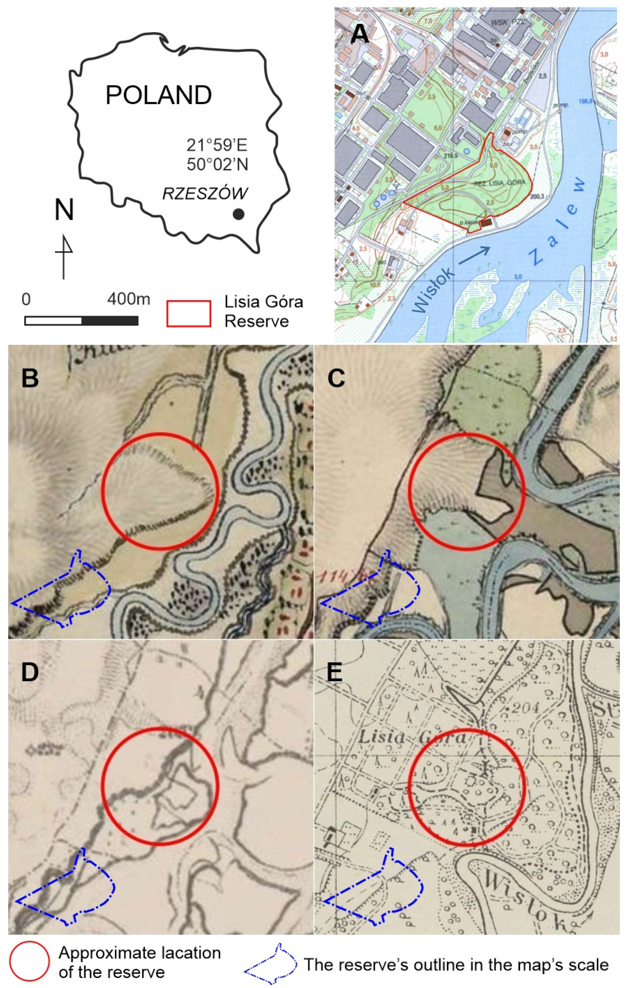
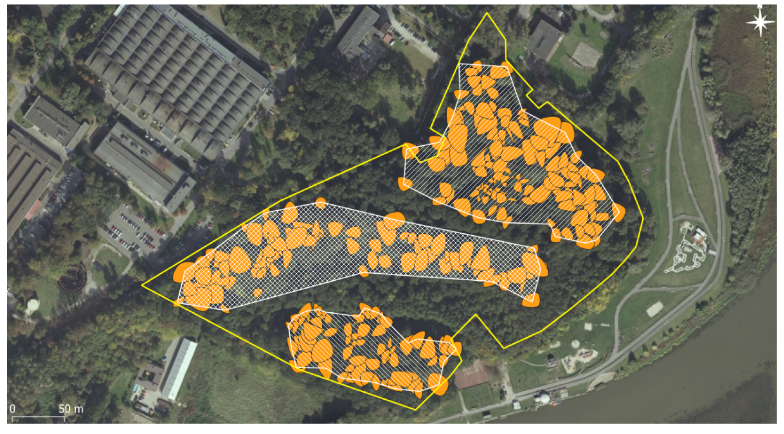
2.1. Study Area
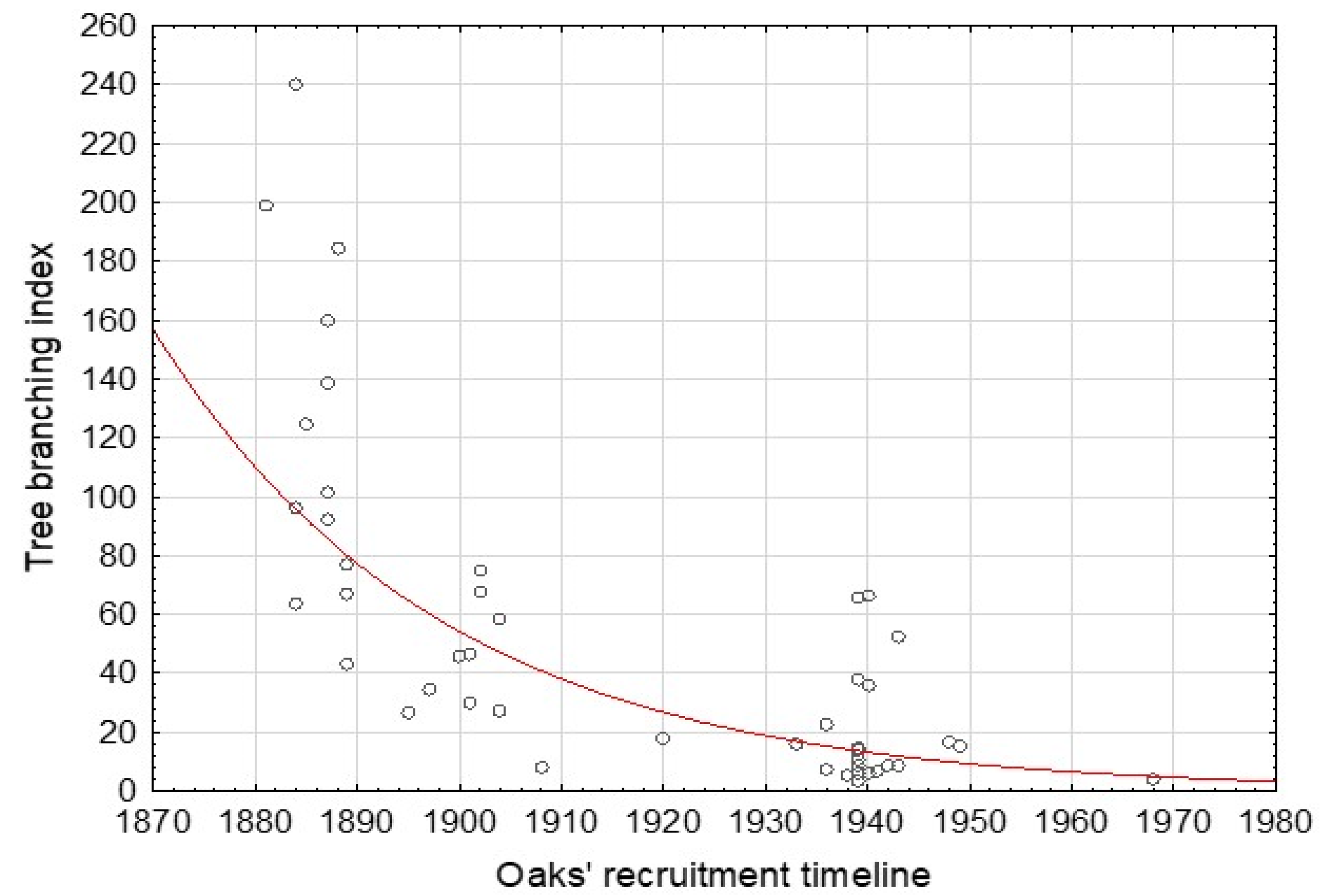
2.2. Stand Inventory and Dendroecological Reconstruction of Oak Stand History
2.3. Tree Regeneration
2.4. Floristic Survey
2.5. Interviews with People
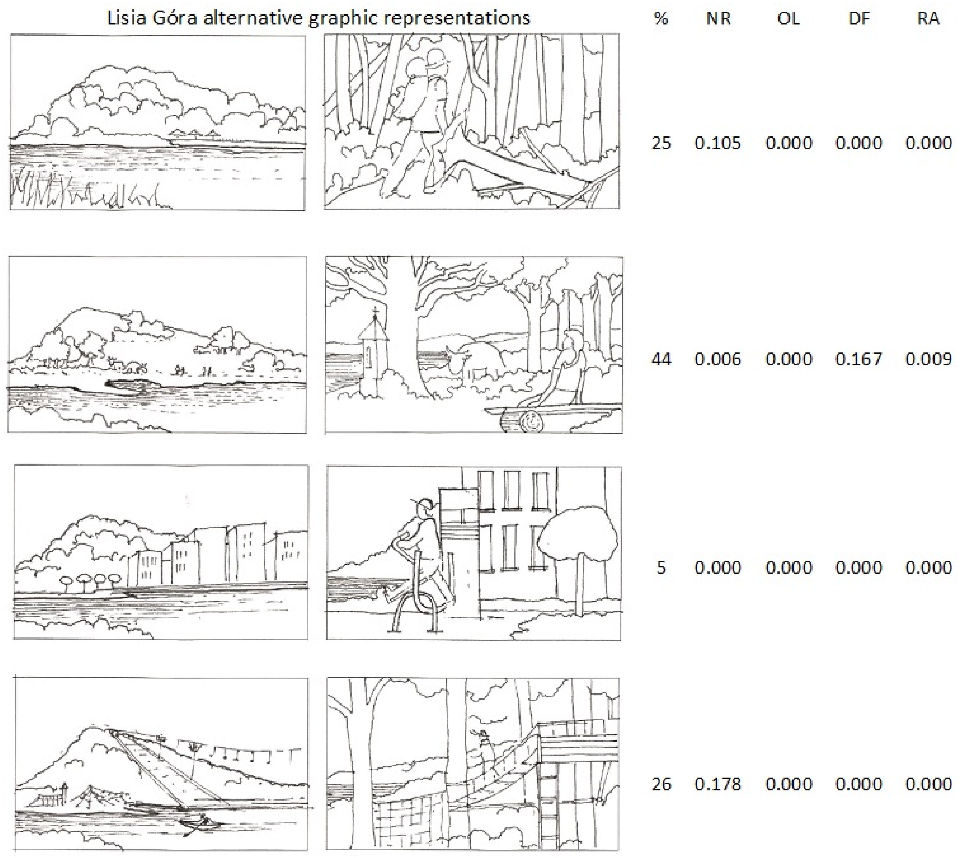
- A.
- Lisia Góra as a dense forest
- B.
- Lisia Góra as a semi-open landscape with solitary trees and small groves
- C.
- Lisia Góra as the backyard of a residential area
- D.
- Lisia Góra as a recreation park with leisure infrastructure
- (See Form S1).
3. Results
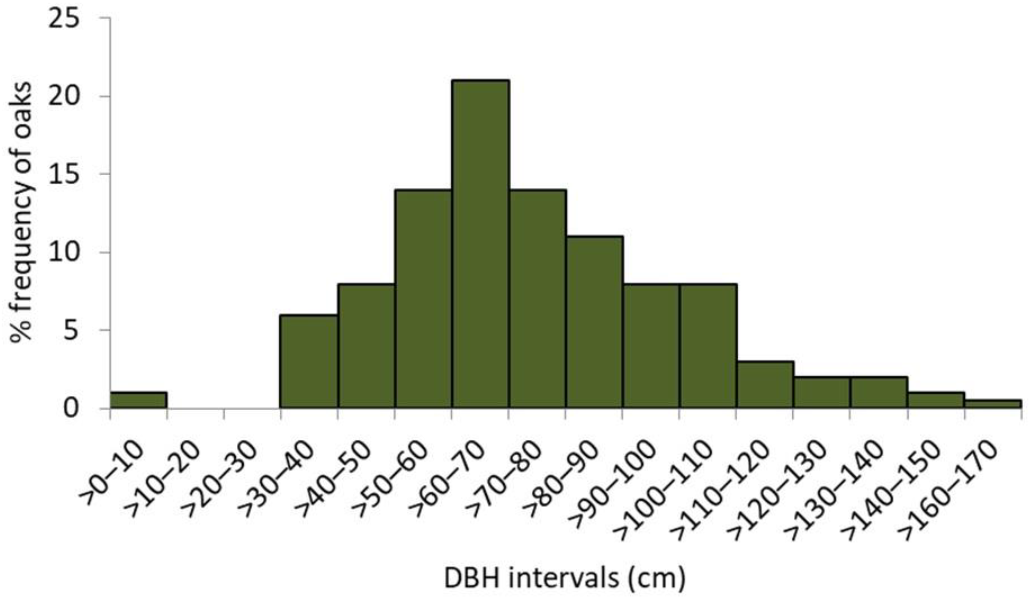
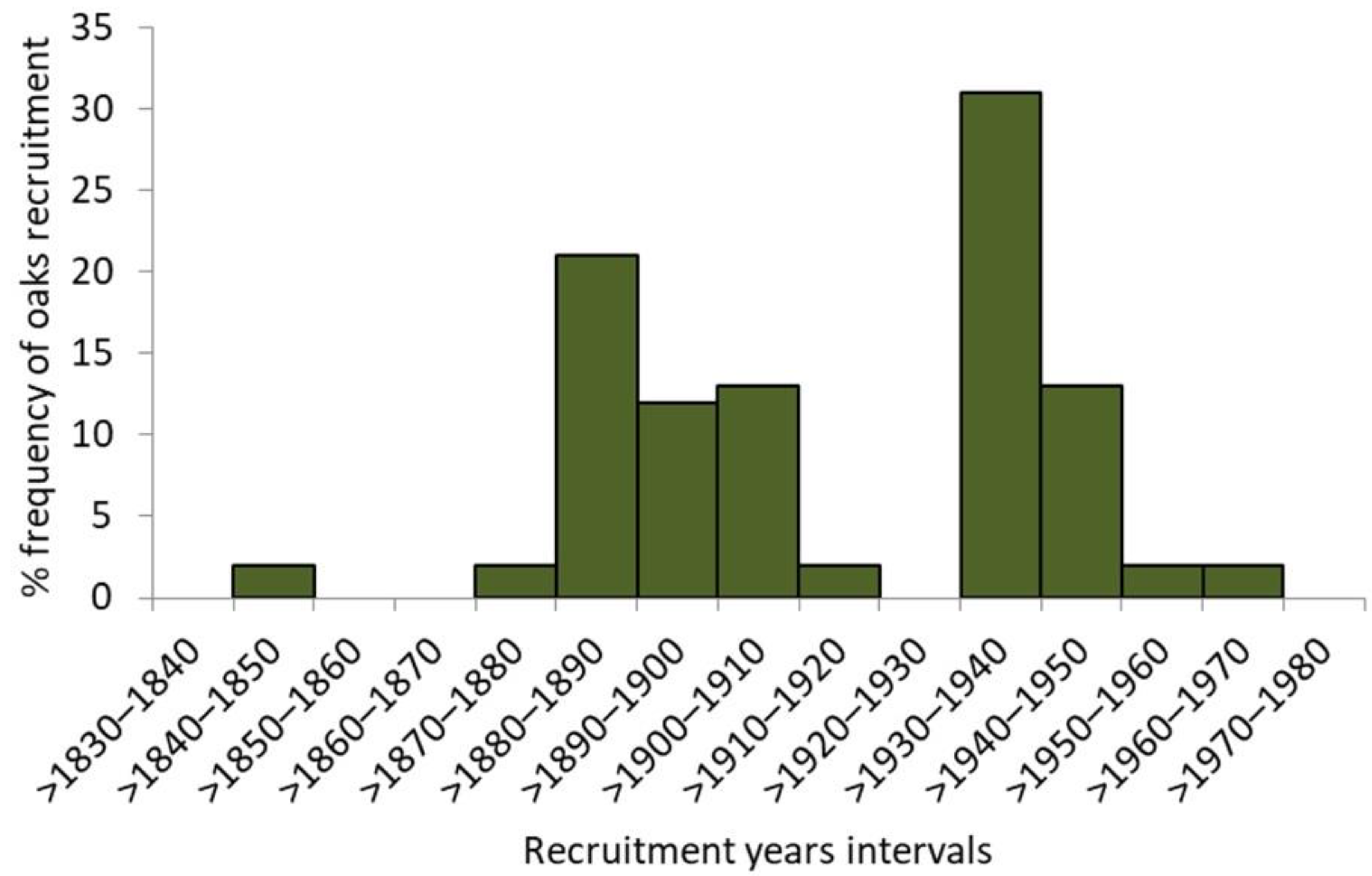
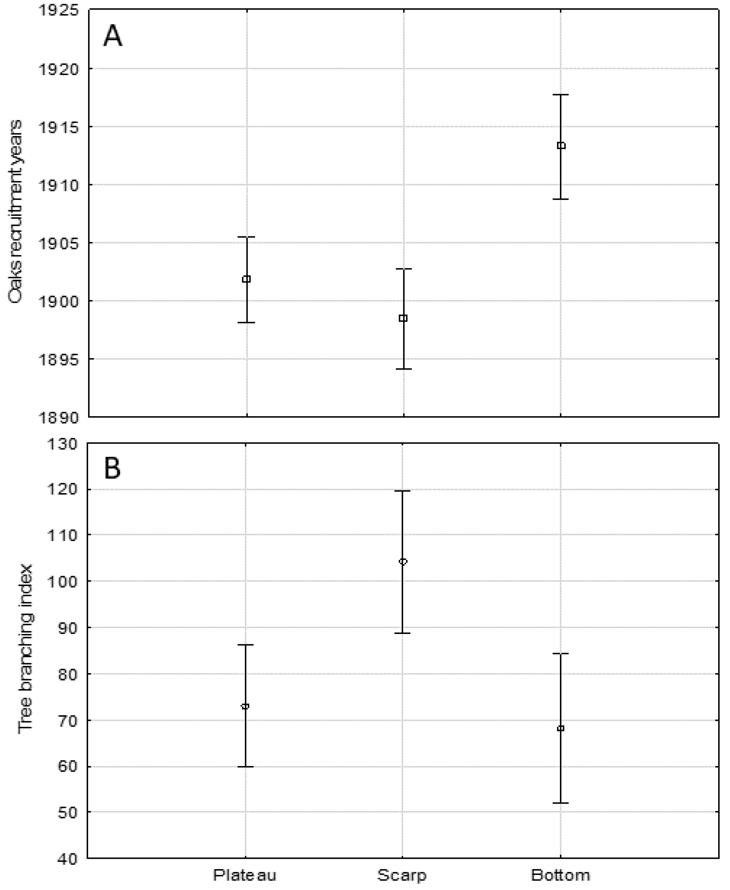
3.1. Oak Stand Characteristics
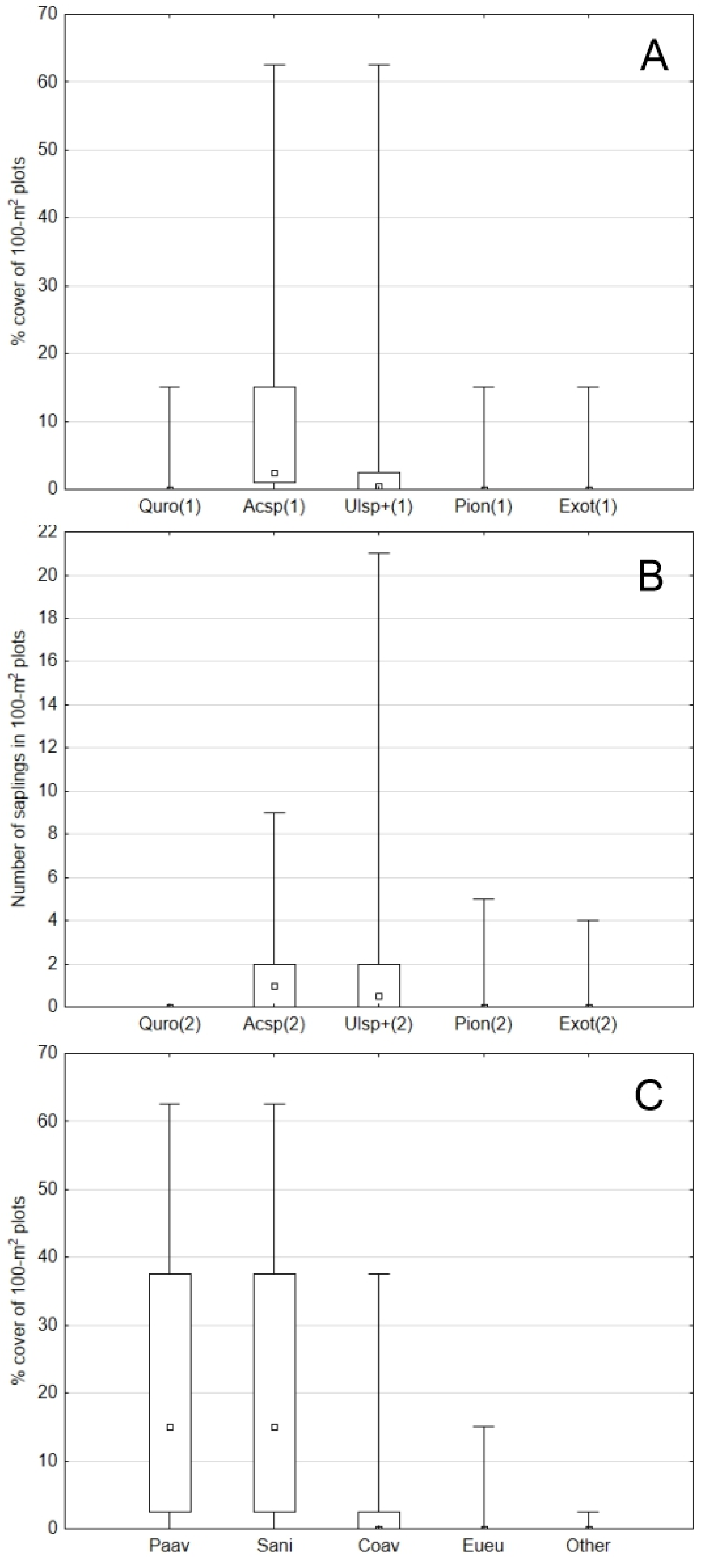
3.2. Undergrowth and Tree Regeneration
3.3. Ground Vegetation
3.4. Visitors’ Views on Lisia Góra Management Scenarios
4. Discussion
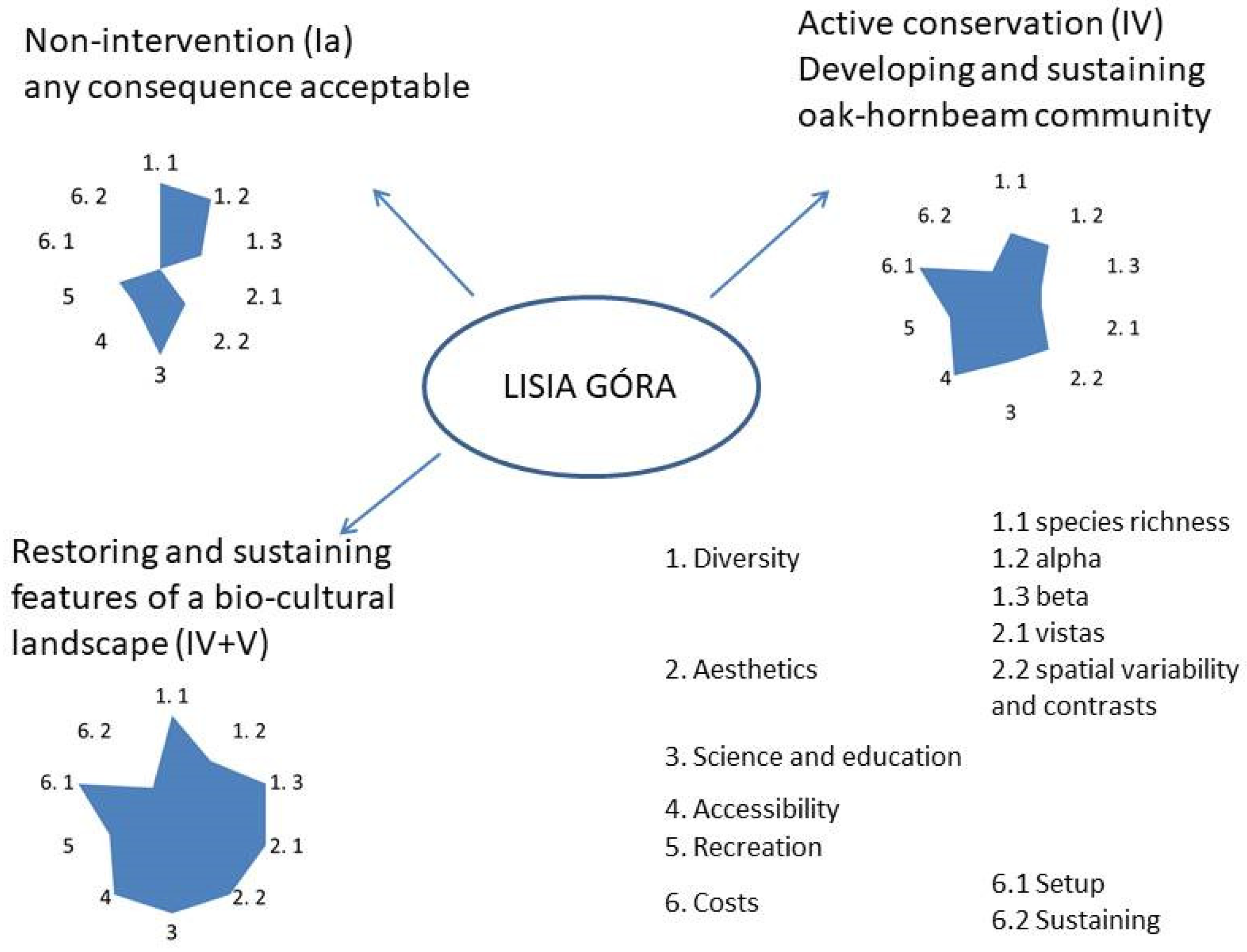
5. Conclusions
Supplementary Materials
Author Contributions
Funding
Institutional Review Board Statement
Informed Consent Statement
Data Availability Statement
Acknowledgments
Conflicts of Interest
References
- Ritchie, H.; Roser, M. Urbanization. Our World in Data. Oxford Martin School, University of Oxford, GCDL, 2019. Available online: Worldindata.org (accessed on 12 July 2021).
- Grebner, D.L.; Bettinger, P.; Siry, J.P.; Boston, K. Chapter 16—Urban. Forestry. Introduction to Forestry and Natural Resources, 2nd ed.; Academic Press: Cambridge, MA, USA; Elsevier Inc.: Amsterdam, The Netherlands, 2021; pp. 387–407. [Google Scholar] [CrossRef]
- Brito, V.V.; Borelli, S. Urban food forestry and its role to increase food security: A Brazilian overview and its potentialities. Urban For. Urban Green. 2020, 56, 126835. [Google Scholar] [CrossRef]
- Giedych, R.; Maksymiuk, G. Specific Features of Parks and Their Impact on Regulation and Cultural Ecosystem Services Provision in Warsaw, Poland. Sustainability 2017, 9, 792. [Google Scholar] [CrossRef] [Green Version]
- Rackham, O. The History of the Countryside: The Full Fascinating Story of Britain’s Landscape; Dent, J.M., Ed.; Sons Ltd.: London, UK, 1986. [Google Scholar]
- MEA. Millennium Ecosystem Assessment. In Ecosystems and Human Well-Being: Synthesis; Island Press: Washington, DC, USA, 2005; p. 137. Available online: http://www.royalsocietyqld.org/wp-content/uploads/2017/11/MEA_Summary_Extract.pdf (accessed on 21 July 2021).
- TEEB. The Economics of Ecosystem and Biodiversity. Ecological and Economic Foundation; Kumar, P., Ed.; Routledge: London, UK, 2010; p. 410. [Google Scholar]
- Sykes, O.; Brown, J.; Cocks, M.; Shaw, D.; Couch, C. A City Profile of Liverpool. Cities 2013, 35, 299–318. [Google Scholar] [CrossRef]
- Slavicek, L.C. New York City’s Central Park (Building America: Then and Now), 1st ed.; Chelsea House Pub: New York, NY, USA, 2009; p. 120. [Google Scholar]
- Barthel, S.; Colding, J.; Emqvist, T.; Folke, C. History and local management of a biodiversity-rich, urban cultural landscape. Ecol. Soc. 2005, 10, 1–27. [Google Scholar] [CrossRef]
- Nowak, D.J.; Bodine, A.R.; Hoehn, R.E.; Edgar, C.B.; Riley, G.; Hartel, D.R.; Dooley, K.J.; Stanton, S.M.; Hatfield, M.A.; Brandeis, T.J.; et al. Houston’s Urban. Forest, 2015; Resource Bulletin SRS-211; US Forest Service, Southern Research Station: Asheville, NC, USA, 2017. Available online: https://www.researchgate.net/deref/http%3A%2F%2Fwww.srs.fs.usda.gov%2Fpubs%2F (accessed on 24 July 2021).
- Colantoni, A.; Egidi, G.; Quaranta, G.; D’Alessandro, R.; Vinci, S.; Turco, R.; Salvati, L. Sustainable Land Management, Wildfire Risk and the Role of Grazing in Mediterranean Urban-Rural Interfaces: A Regional Approach from Greece. Land 2020, 9, 21. [Google Scholar] [CrossRef] [Green Version]
- Davis, S. Urban foodscapes and greenspace design: Integrating grazing landscapes within multi-use urban parks. Front. Sustain. Food Syst. 2021, 5, 559025. [Google Scholar] [CrossRef]
- Ranacher, L.; Sedmik, A.; Schwarzbauer, P. Public Perceptions of Forestry and the Forest-Based Bioeconomy in the European Union; Knowledge to Action 3; European Forest Institute: Joensuu, Finland, 2020; p. 104. [Google Scholar] [CrossRef]
- Heyman, E. Analysing recreational values and management effects in an urban forest with the visitor-employed photography method. Urban. For. Urban. Green. 2012, 11, 267–277. [Google Scholar] [CrossRef]
- Pelyukh, O.; Zachvoyska, L.; Paletto, A. Comparison between people’s perceptions and preferences towards forest stand characteristics in Italy and Ukraine. Ann. Silvic. Res. 2019, 43, 4–14. [Google Scholar]
- Gundersen, V.; Köhler, B.; Myrvold, K.M. Seeing the Forest for the Trees: A Review-Based Framework for Better Harmonization of Timber Production, Biodiversity, and Recreation in Boreal Urban Forests. Urban. Sci. 2019, 3, 113. [Google Scholar] [CrossRef] [Green Version]
- Lee, T.R. Perceptions, Attitudes and Preferences in Forests and Woodlands; Technical Paper—Forestry Commission 2001; CAB Direct: Edinburgh, UK; p. 166. Available online: https://www.cabdirect.org/cabdirect/abstract/20023067232 (accessed on 21 July 2021).
- Appleton, J. The Experience of Landscape; Wiley and Sons: London, UK, 1975; p. 293. [Google Scholar]
- Orians, G.H.; Heerwagen, J.H. Evolved responses to landscapes. In The Adapted Mind: Evolutionary Psychology and The Generation of Culture; Barkow, J.H., Cosmides, L., Tooby, J., Eds.; Oxford University Press: New York, NY, USA, 1992; pp. 555–579. [Google Scholar]
- Sommer, R. Further cross national studies of tree form preferences. Ecol. Psychol. 1997, 9, 153–160. [Google Scholar] [CrossRef]
- Statistics Poland. Local Data Base. 2020. Available online: https://bdl.stat.gov.pl/ (accessed on 16 July 2021).
- Serwis Informacyjny Urzędu Miasta Rzeszowa (Information Service of the Rzeszów City Hall). Rozszerzenie Granic RZESZOWA. Available online: Erzeszow.pl (accessed on 16 July 2021).
- Bonusiak, A. Terytoria przyłączone do Rzeszowa w pierwszym dziesięcioleciu XXI wieku, ich historia i stan dzisiejszy (Territories included to Rzeszów in the first decade of the 21st century, their history and present state). In Dzieje Rzeszowa. T. 5. Rzeszów w Latach 1989–2015 (The History of Rzeszów. Vol. 5. Rzeszów in the Years 1989–2015); Bonusiak, A., Ed.; Polskiej Bibliografii Naukowej: Rzeszów, Poland, 2017; pp. 55–102. [Google Scholar]
- Bobiec, A.; Paderewski, J.; Gajdek, A. Urbanisation and globalised environmental discourse do not help to protect the bio-cultural legacy of rural landscapes. Landsc. Urban. Plan. 2021, 208. [Google Scholar] [CrossRef]
- Bobiec, A.; Reif, A.; Öllerer, K. Seeing the oakscape beyond the forest: A landscape approach to the oak regeneration in Europe. Landsc. Ecol. 2018, 33, 513–528. [Google Scholar] [CrossRef] [Green Version]
- Zimnal, Z.; Tablica, I. Szkic geomorfologiczny. In Objaśnienia Do Szczegółowej Mapy Geologicznej Polski, Skala 1:50,000, Arkusz Rzeszów 982; Zimnal, Z., Malata, T., Eds.; PIG PIB: Warszawa, Poland, 2014. [Google Scholar]
- Wójcik, T.; Ziaja, M.; Makuch, I.; Ćwik, A.; Kotańska, M. Vegetation of the Lisia Góra Reserve in Rzeszów. Fragm. Florist. Et Geobot. Pol. 2018, 25, 21–43. [Google Scholar]
- Wójcik, T.; Makuch, I.; Ćwik, A.; Ziaja, M. Anthropogenic changes in selected elements of the natural environment in the Lisia Góra forest nature reserve in Rzeszów. Sylwan 2020, 164, 246–253. [Google Scholar] [CrossRef]
- Bobiec, A.; Podlaski, R.; Ortyl, B.; Korol, M.; Havryliuk, S.; Öllerer, K.; Ziobro, J.K.; Pilch, K.; Dychkevych, K.; Dudek, T.; et al. Top-down segregated policies undermine the maintenance of traditional wooded landscapes: Evidence from oaks at the European Union’s eastern border. Landsc. Urban. Plan. 2019, 189, 247–259. [Google Scholar] [CrossRef]
- Rinn, F. TSAP-WinTM Time Series Analysis and Presentation for Dendrochronology and Related Applications Version 0.53 for Microsoft Windows 98, 2000, XP; Rinntech: Heilderberg, Germany, 2003. [Google Scholar]
- Rozas, V. Tree age estimates in Fagus sylvatica and Quercus robur: Testing previous and improved methods. Plant. Ecol. 2003, 167, 193–212. [Google Scholar] [CrossRef]
- Snowarski, M. Atlas of Vascular Plants of Poland. Available online: http://www.atlas-roslin.pl/index.html (accessed on 21 April 2021).
- Alien Species in Poland, 2009. Available online: http://www.iop.krakow.pl/ias/species (accessed on 14 July 2021).
- Matuszkiewicz, W.A. Guide for Identification of Polish Plant. Communities; Polish Scientific Publishers PWN: Warsaw, Poland, 2017; p. 536. [Google Scholar]
- Dzwonko, Z.; Loster, S. Wskaźnikowe gatunki roślin starych lasów i ich znaczenie dla ochrony przyrody i kartografii roślinności. Pr. Geogr. PAN 2001, 178, 119–132. [Google Scholar]
- Pladias. Database of the Czech Flora and Vegetation. 2014–2019. Available online: http://www.pladias.org (accessed on 14 July 2021).
- Wójcik, T. Bogactwo florystyczne lasu ”Ratośniówki” na Pogórzu Strzyżowskim. Chrońmy Przyr. Ojcz. 2012, 68, 26–35. [Google Scholar]
- Molnár, G.; Timár, G.; Biszak, E. Can The First Military Survey Maps of the Habsburg Empire (1763–1790) Be Georeferenced by An Accuracy of 200 Meters? In Proceedings of the 9th International Workshop on Digital Approaches to Cartographic Heritage, Budapest, Hungary, 4–5 September 2014; pp. 127–132. [Google Scholar] [CrossRef]
- Projekt Parku Miejskiego w Rzeszowie Na Gruntach Miejskich Nad Wisłokiem. Lwów, 1937. Akta Miasta Rzeszowa (Files of The City of Rzeszów) 457/37; Polish State Archives: Rzeszów, Poland, 1937.
- Kwartalny Biuletyn Informacyjny (Quarterly Information Bulletin) 1938; Kraków, Poland; p. 8. Available online: https://jbc.bj.uj.edu.pl/dlibra/publication/401554/edition/379310 (accessed on 22 July 2021).
- Kwartalny Biuletyn Informacyjny o Ochronie Przyrody (Quarterly Information Bulletin Concerning the Protection of Nature) 1939; Kraków, Poland; p. 9. Available online: https://jbc.bj.uj.edu.pl/dlibra/publication/401558/edition/379312 (accessed on 22 July 2021).
- Ellenberger, H.; Weber, H.E.; Düll, R.; Wirth, V.; Werner, W.; Paulißen, D. Zeigerwerte von Pflanzen in Mitteleuropa. Scr. Geobot. 1992, 18. [Google Scholar] [CrossRef]
- Vera, F.W.M. Grazing Ecology and Forest History; CABI Publishing: Wallingford, UK, 2000. [Google Scholar] [CrossRef]
- Petritan, I.C.; Marzano, R.; Petritan, A.M.; Lingua, E. Overstory succession in a mixed Quercus petraea-Fagus sylvatica old growth forest revealed through the spatial pattern of competition and mortality. For. Ecol. Manag. 2014, 326, 9–17. [Google Scholar] [CrossRef]
- Dolezal, J.; Leheckova, E.; Sohar, K.; Altman, J. Oak decline induced by mistletoe, competition and climate change: A case study from central Europe. Preslia 2016, 88, 323–346. [Google Scholar]
- Bobiec, A. The influence of gaps on tree regeneration: A case study of the mixed lime-hornbeam (Tilio-Carpinetum Tracz. 1962) communities in the Białowieża Primeval Forest. Pol. J. Ecol. 2007, 55, 441–455. [Google Scholar]
- Bobiec, A.; Bobiec, M. Influence of spruce decline in stands of the Białowieża National Park on natural oak regeneration. Sylwan 2012, 156, 243–251. [Google Scholar] [CrossRef]
- Kozłowska, A. The forest communities in the Przemyśl Foothils, south-east Poland. Fragm. Flor. Geobot. 2000, 45, 345–372. [Google Scholar]
- Towpasz, K.; Stachurska-Swakoń, A. Alder-ash and willow communities and their diversity in the Pogórze Strzyżowskie Foothills (Western Carpathians). Acta Soc. Bot. Pol. 2008, 77, 327–338. [Google Scholar]
- Towpasz, K.; Stachurska-Swakoń, A. Diversity of the forest communities from the Carpinion betuli and Fagion sylvaticae alliances in the Strzyżowskie Foothills, Western Carpathians. Fragm. Florist. Geobot. Polon. 2010, 17, 315–359. [Google Scholar]
- Wójcik, T.; Rogus, A.; Ćwik, A. Plan communities in the “Św. Roch” forest in Rzeszów (Dynowskie Foothilla). Fragm. Florist. Geobot. Polon. 2016, 23, 101–120. [Google Scholar]
- Wolański, P.; Bobiec, A.; Ortyl, B.; Makuch-Pietraś, I.; Czarnota, P.; Ziobro, J.; Korol, M.; Havryliuk, S.; Paderewski, J.; Kirby, K. The importance of livestock grazing at woodland-grassland interface in the conservation of rich oakwood plant communities in temperate Europe. Biodivers. Conserv. 2021, 30, 741–760. [Google Scholar] [CrossRef]
- Close, F.; Berkes, J.; Colding, C.; Folke, C. Rediscovery of traditional ecological knowledge as adaptive management. Ecol. Appl. 2000, 10, 1251–1262. [Google Scholar] [CrossRef]
- Soga, M.; Gaston, K.J. Shifting baseline syndrome: Causes, consequences, and implications. Front. Ecol. Environ. 2018, 16, 222–230. [Google Scholar] [CrossRef] [Green Version]
- Lonsdale, D. Ancient and Other Veteran Trees: Further Guidance on Management; The Three Council: London, UK, 2013; p. 212. [Google Scholar]
- Barthel, S.; Crumley, C.; Svedin, U. Bio-cultural refugia—Safeguarding diversity of practices for food security and biodiversity. Glob. Environ. Chang. 2013, 23, 1142–1152. [Google Scholar] [CrossRef] [Green Version]


| Species in toto | LG | LG(OH) | OH | LG(RM) | RM |
| 215 | 147 | 209 | 173 | 184 | |
| origin | |||||
| native | 190 | 124 | 194 | 156 | 180 |
| alien (*) | 24(13) | 23(13) | 15(7) | 17(9) | 4(4) |
| life form | |||||
| Ph | 57 | 46 | 42 | 48 | 38 |
| Ch | 7 | 6 | 13 | 5 | 10 |
| H | 94 | 58 | 93 | 72 | 88 |
| G | 29 | 17 | 39 | 24 | 39 |
| T | 23 | 20 | 22 | 19 | 7 |
| Hy | 5 | 5 | 0 | 2 | 0 |
| ecological affinity | |||||
| forest | 109 | 86 | 117 | 87 | 121 |
| meadow, grassland | 44 | 22 | 57 | 34 | 32 |
| ruderal | 40 | 38 | 33 | 30 | 17 |
| water, marsh | 22 | 0 | 2 | 22 | 14 |
| dispersal | |||||
| autochory | 109 | 75 | 120 | 83 | 92 |
| other | 106 | 72 | 89 | 90 | 92 |
| ancient woodland species/ other species | |||||
| /any other | 45/170 | 37/110 | 65/144 | 33/140 | 70/114 |
| /other forest | 45/64 | 37/49 | 65/52 | 33/54 | 70/51 |
| Way of Management | Symbol | Interviewees’ Evaluation | Independence | |||||
|---|---|---|---|---|---|---|---|---|
| Positive | Negative | Neutral | ||||||
| Nature reserve with legal access restrictions | NR | 31 | 48 | 21 | * | |||
| Open landscape with visible topography and groups of notable trees | OL | 72 | 12 | 16 | * | |||
| Dense forest following the course of nature | DF | 51 | 23 | 26 | * | |||
| Area of mass recreation (playground, rope park, toboggan run, etc.) | RA | 42 | 41 | 17 | * | |||
Publisher’s Note: MDPI stays neutral with regard to jurisdictional claims in published maps and institutional affiliations. |
© 2021 by the authors. Licensee MDPI, Basel, Switzerland. This article is an open access article distributed under the terms and conditions of the Creative Commons Attribution (CC BY) license (https://creativecommons.org/licenses/by/4.0/).
Share and Cite
Bobiec, A.; Ćwik, A.; Gajdek, A.; Wójcik, T.; Ziaja, M. Between Pocket Forest Wilderness and Restored Rural Arcadia: Optimizing the Use of a Feral Woodland Enclave in Urban Environment. Forests 2021, 12, 1173. https://doi.org/10.3390/f12091173
Bobiec A, Ćwik A, Gajdek A, Wójcik T, Ziaja M. Between Pocket Forest Wilderness and Restored Rural Arcadia: Optimizing the Use of a Feral Woodland Enclave in Urban Environment. Forests. 2021; 12(9):1173. https://doi.org/10.3390/f12091173
Chicago/Turabian StyleBobiec, Andrzej, Agata Ćwik, Agata Gajdek, Tomasz Wójcik, and Maria Ziaja. 2021. "Between Pocket Forest Wilderness and Restored Rural Arcadia: Optimizing the Use of a Feral Woodland Enclave in Urban Environment" Forests 12, no. 9: 1173. https://doi.org/10.3390/f12091173
APA StyleBobiec, A., Ćwik, A., Gajdek, A., Wójcik, T., & Ziaja, M. (2021). Between Pocket Forest Wilderness and Restored Rural Arcadia: Optimizing the Use of a Feral Woodland Enclave in Urban Environment. Forests, 12(9), 1173. https://doi.org/10.3390/f12091173