Multi-Time Scale Evaluation of Forest Water Conservation Function in the Semiarid Mountains Area

Abstract
1. Introduction
2. Materials and Methods
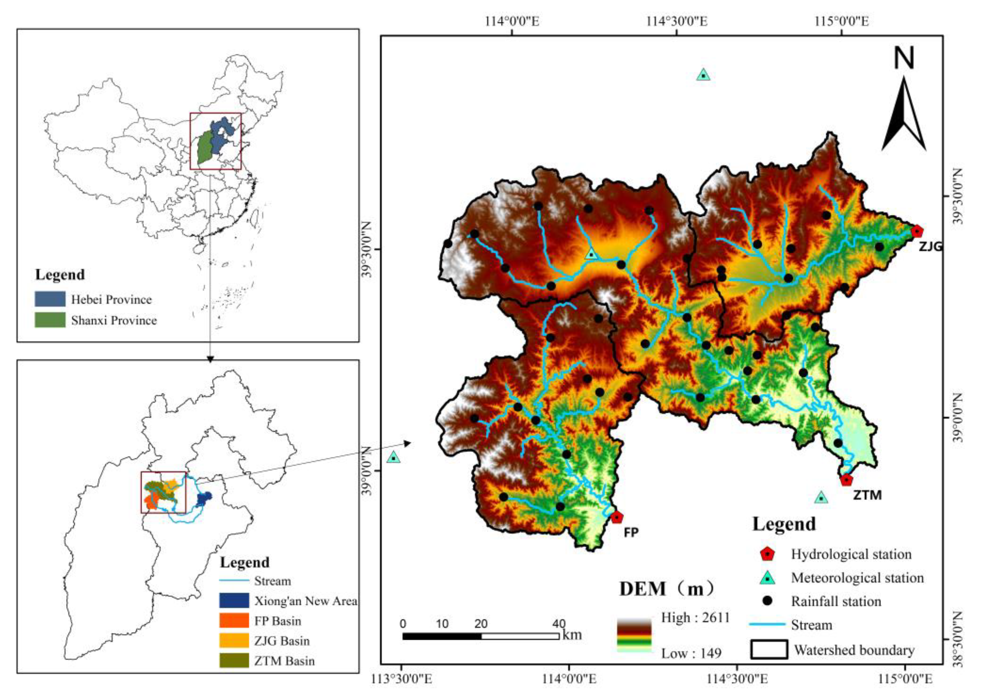
2.1. Overview of the Study Area
2.2. Data Sources
2.3. Construction of the SWAT Model
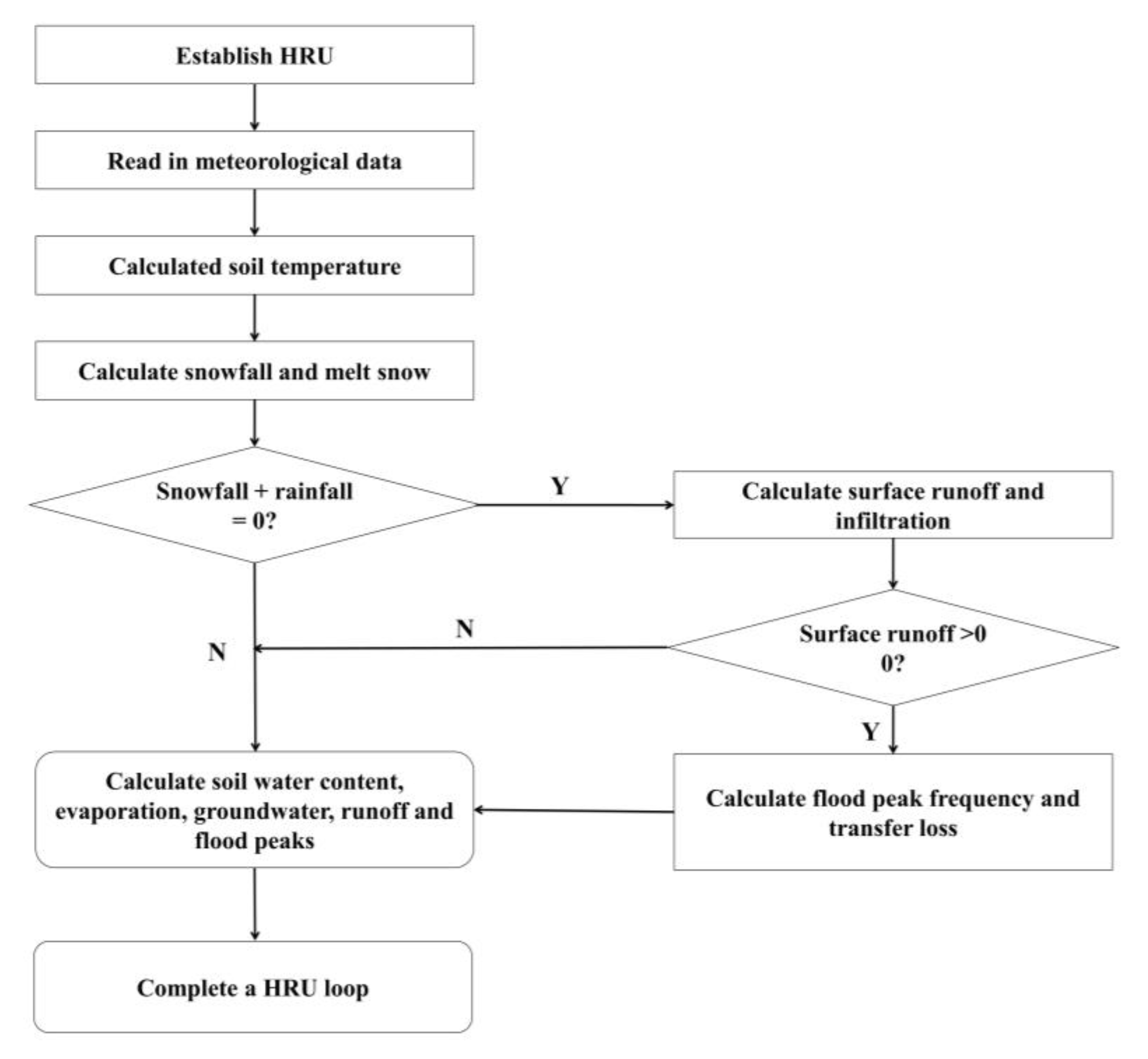
2.3.1. Division of Hydrological Response Units
2.3.2. Model Construction and Parameter Calibration
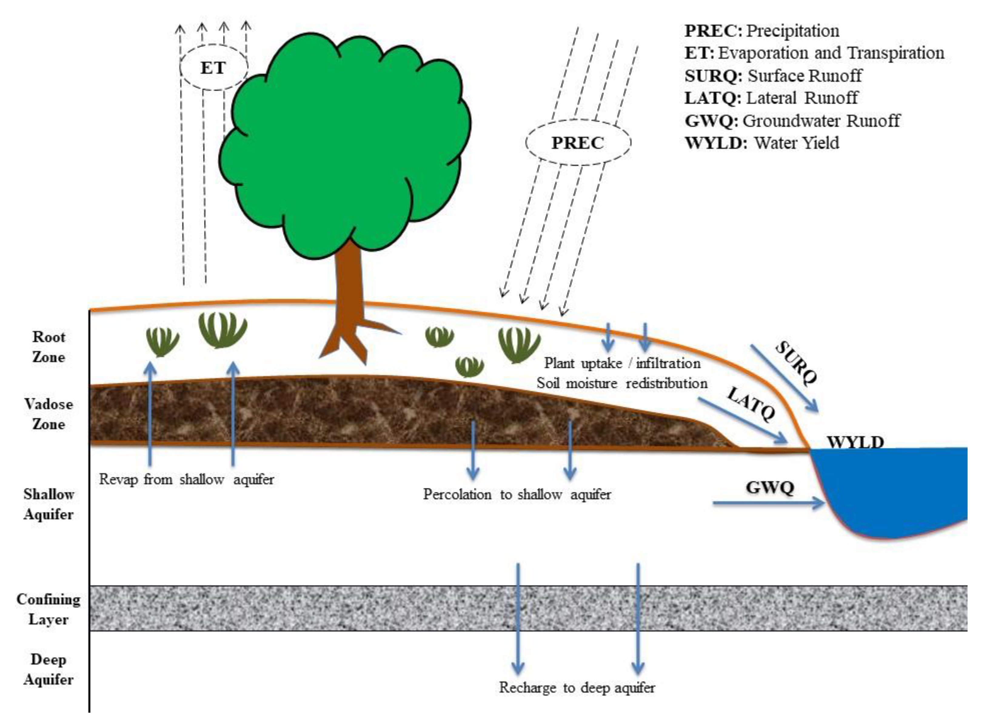
2.4. The Calculation Method of AFWC Based on the SWAT Model
2.5. Selection of Daily Time Scale Eigenvalues
3. Results
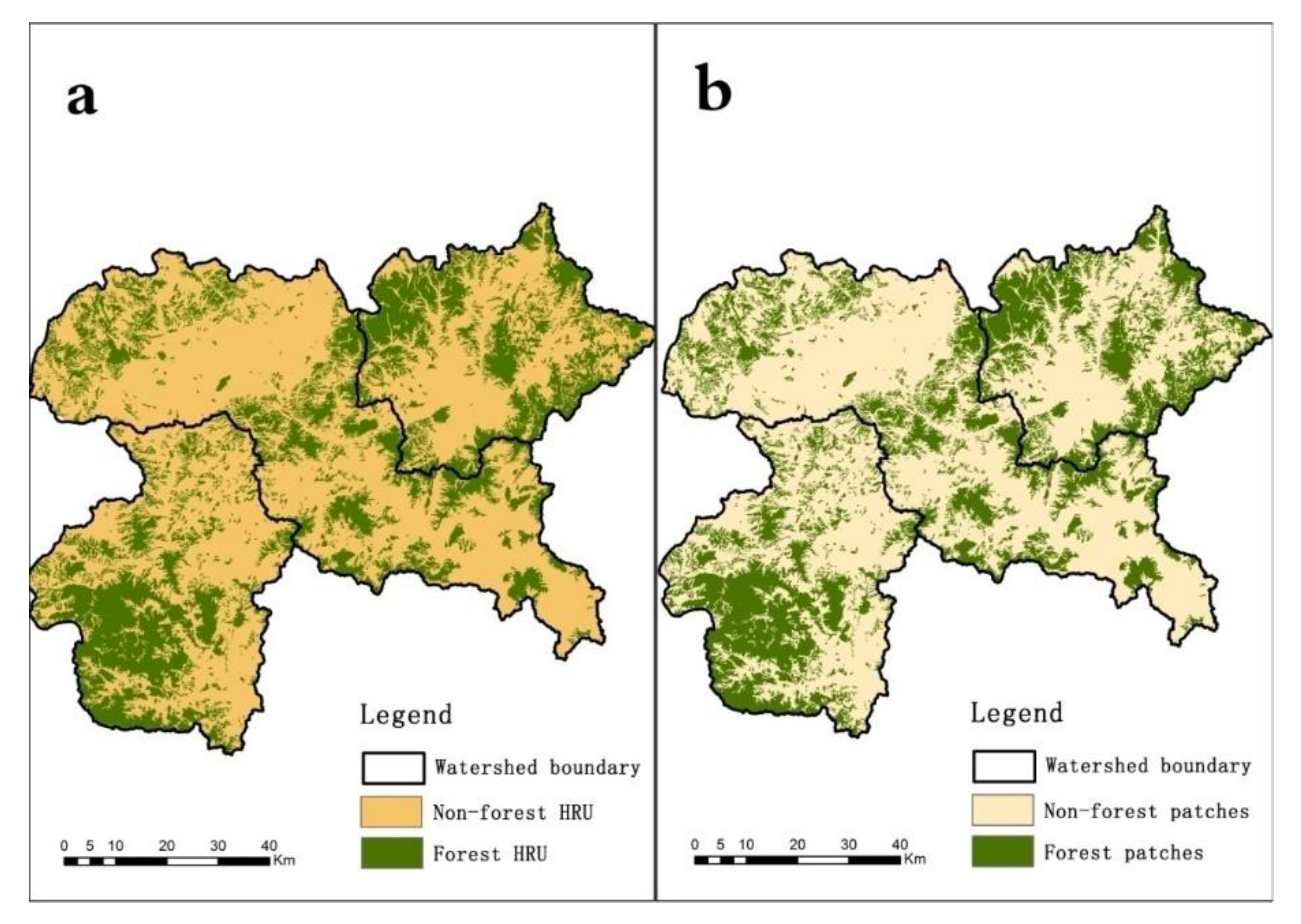
3.1. Spatial Distribution of FHRU
3.2. Model Calibration and Validation
3.3. The Amount of Forest Water Conservation (AFWC) at Different Time Scales
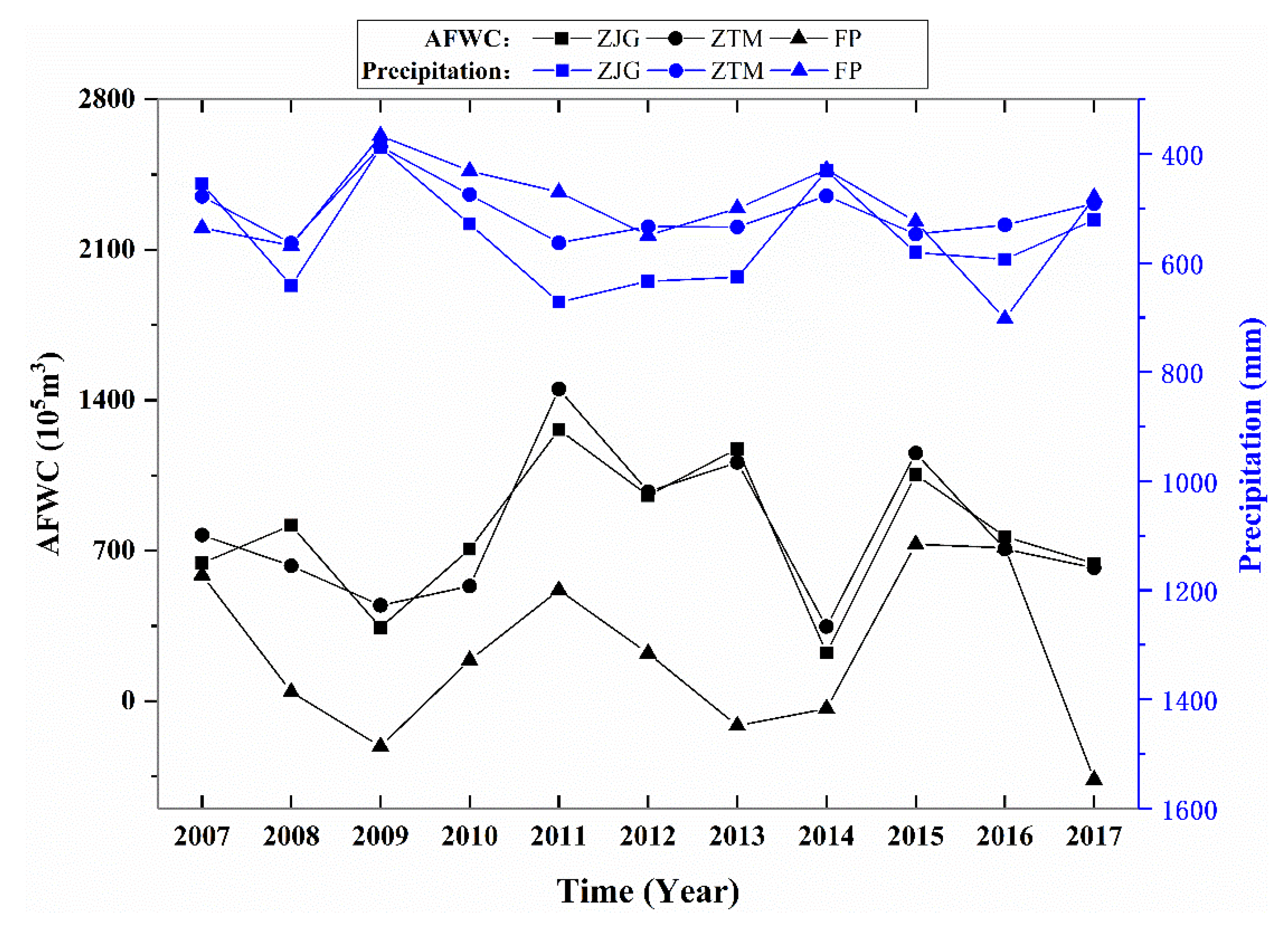
3.3.1. Annual Conservation Amount
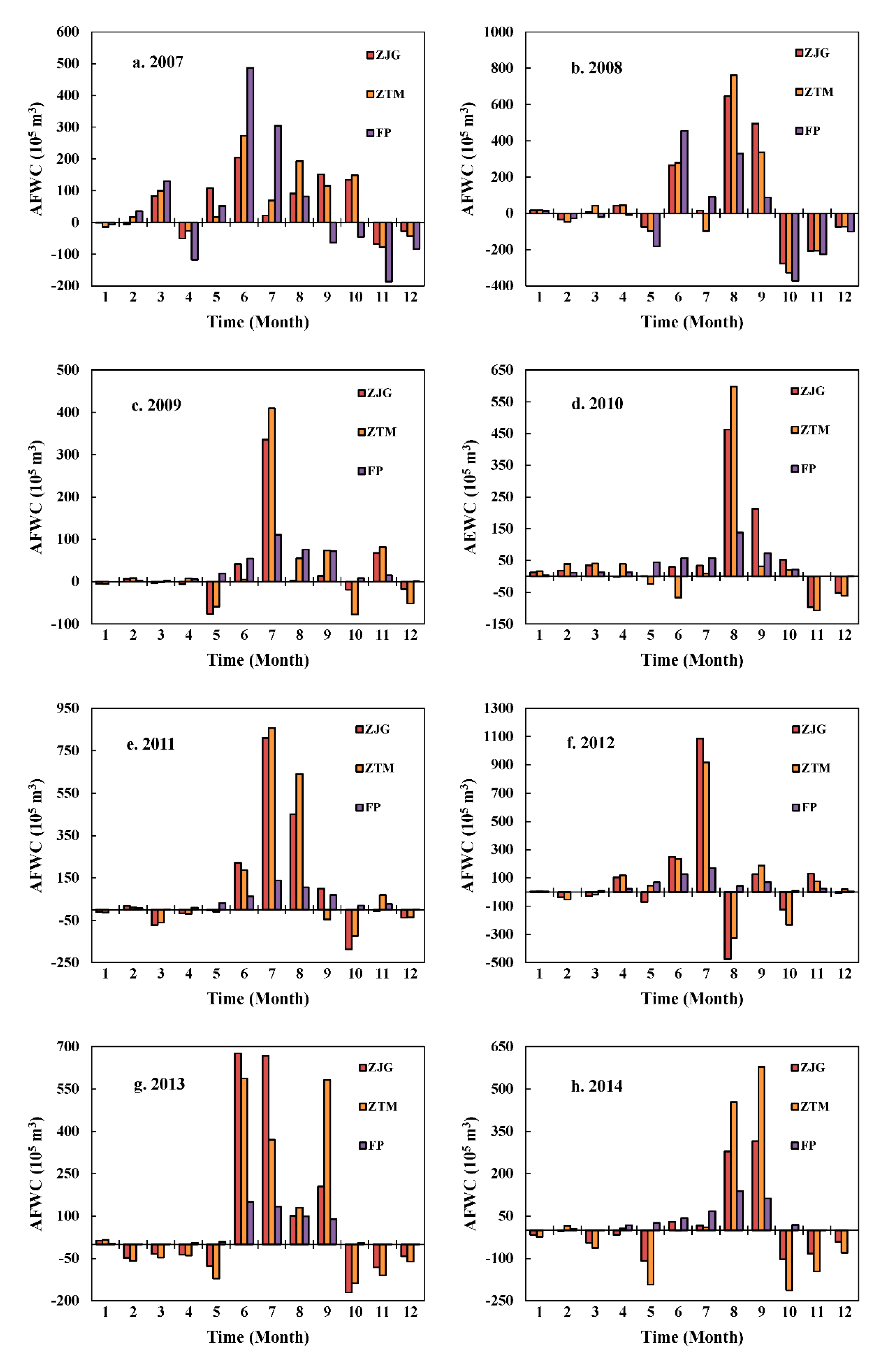
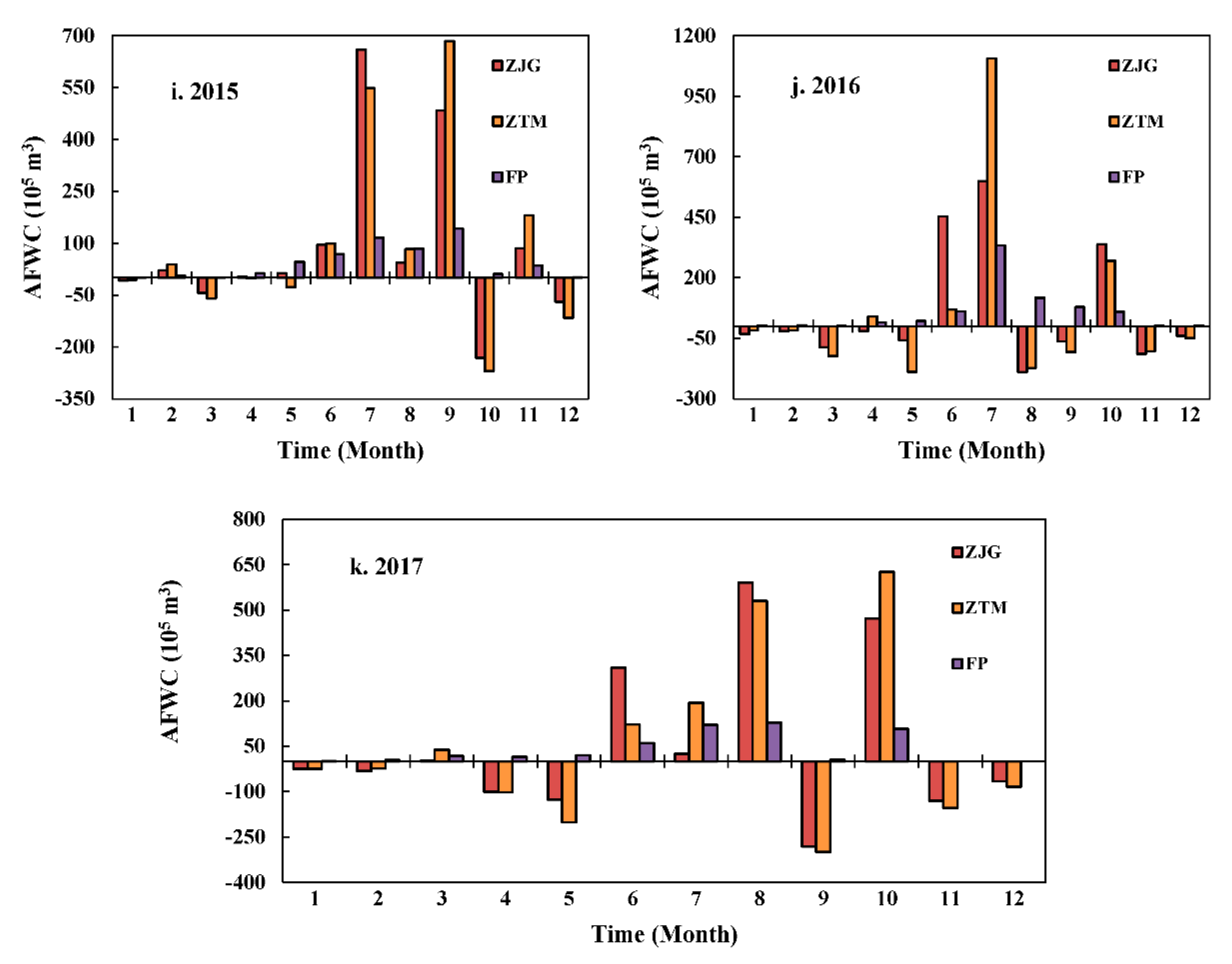
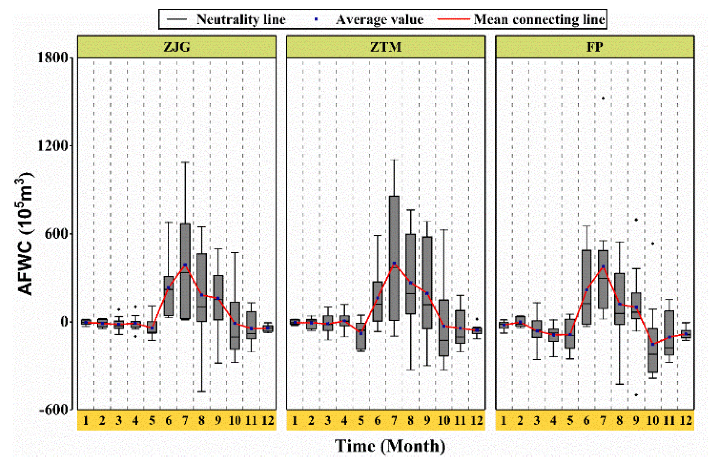
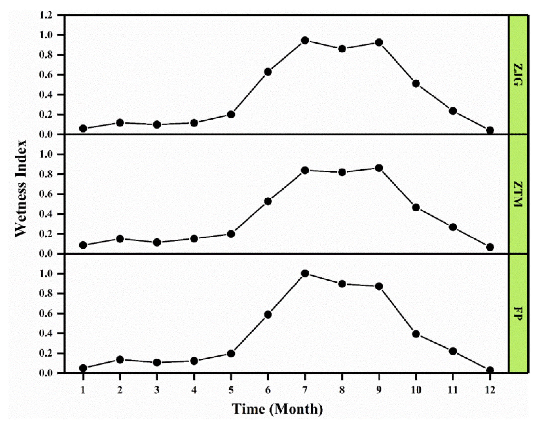
3.3.2. Monthly Conservation Amount
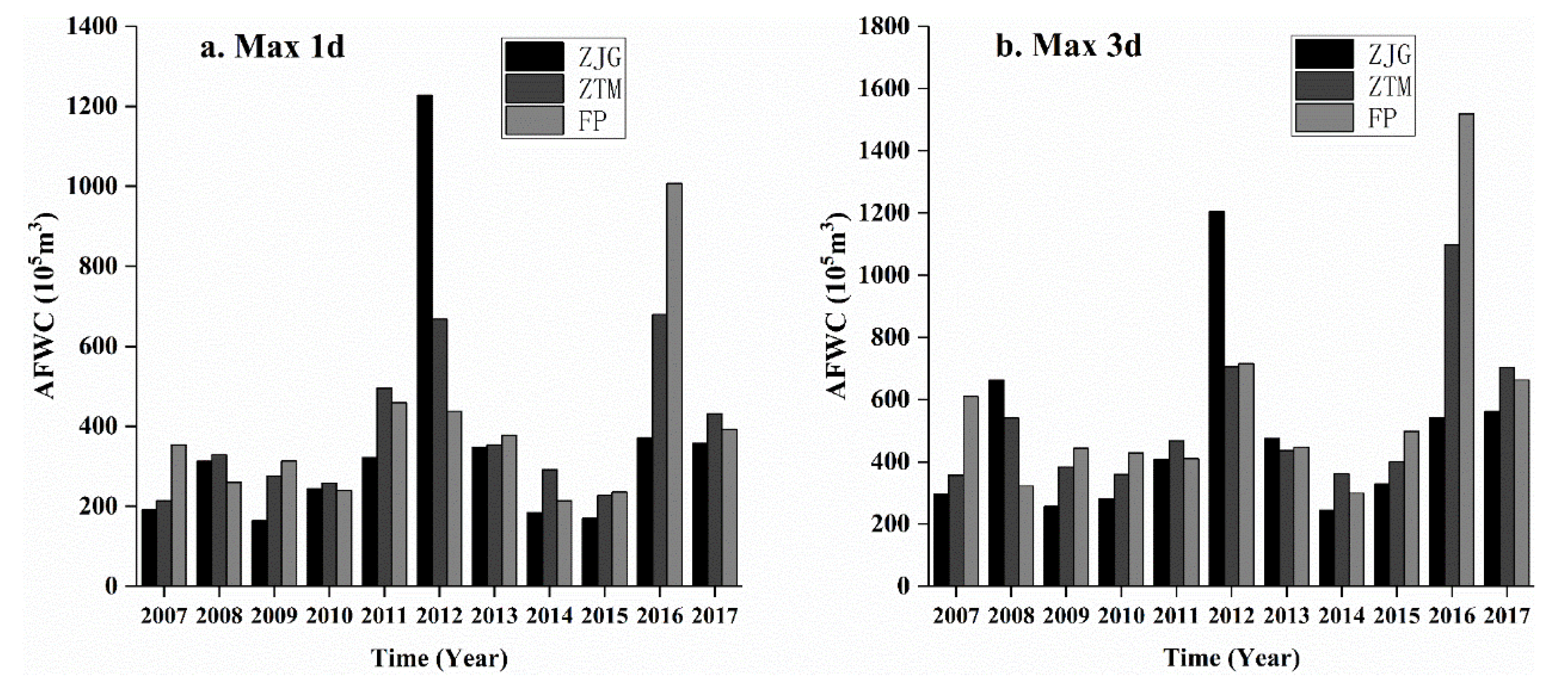
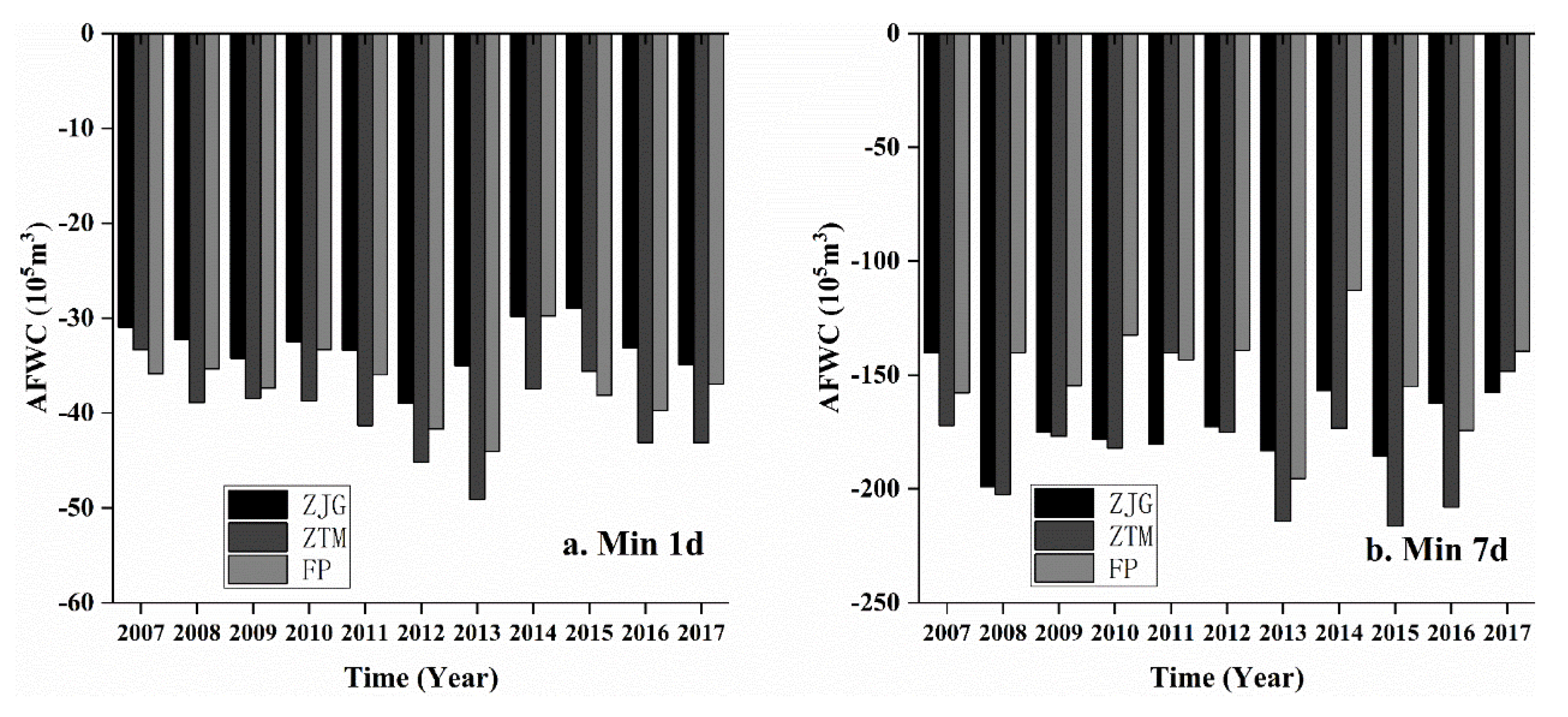
3.3.3. Daily Conservation Amount
4. Discussion
4.1. The Influence of the Area Threshold of Hydrological Response Unit (HRU) on the Generalization of the Land-Use Area
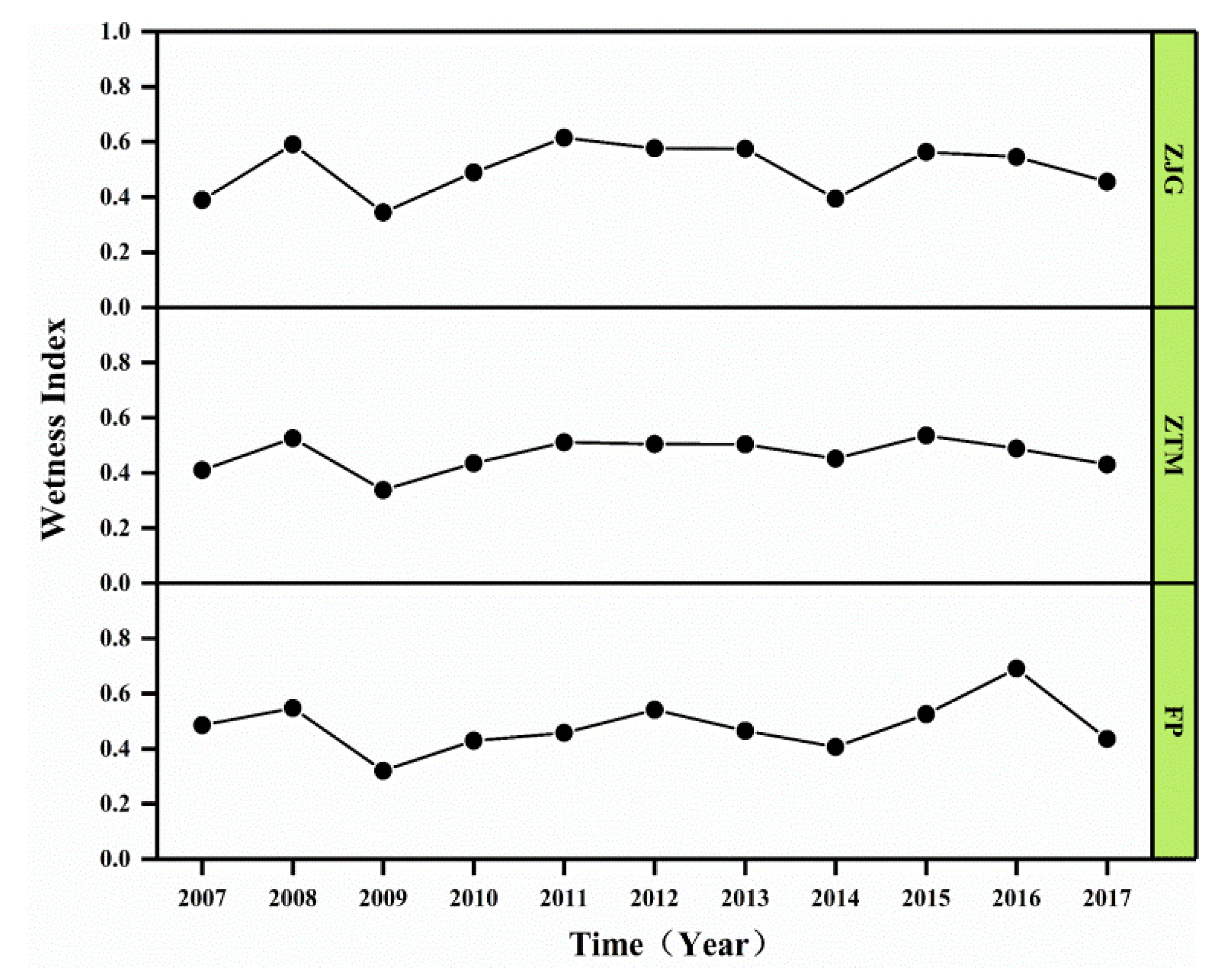
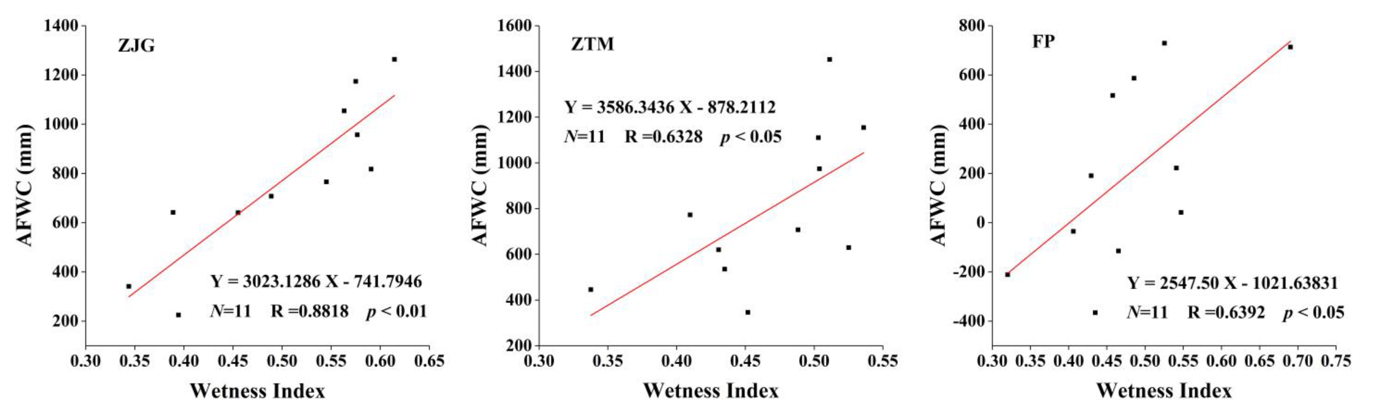
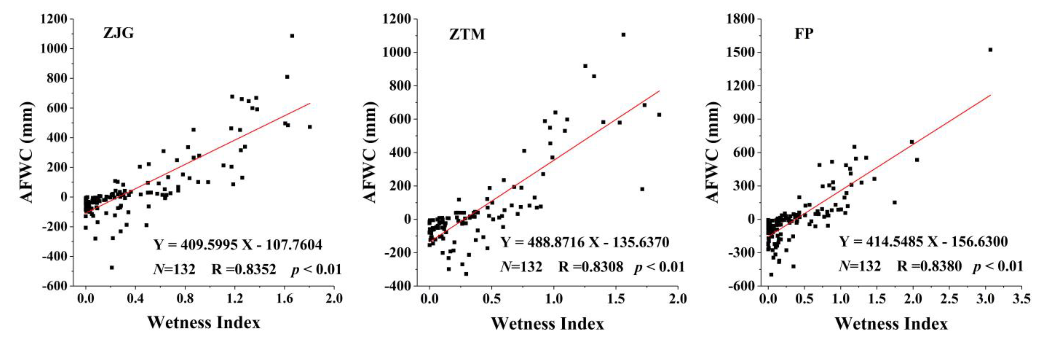
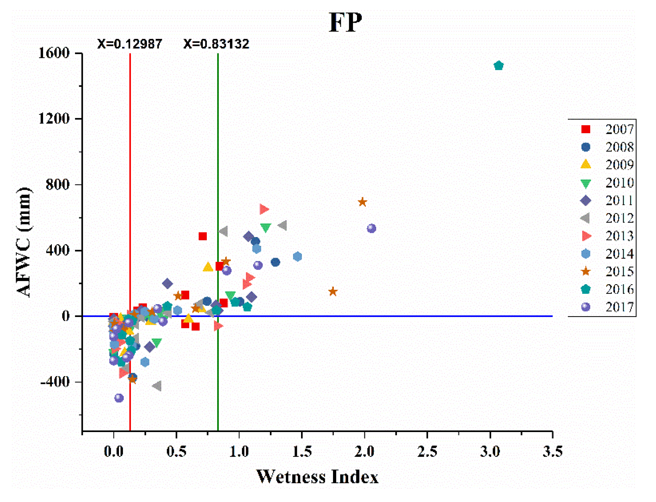
4.2. The Influence of Climate Characteristics on the Amounts of Forest Water Conservation (AFWCs)
4.2.1. Annual Scale
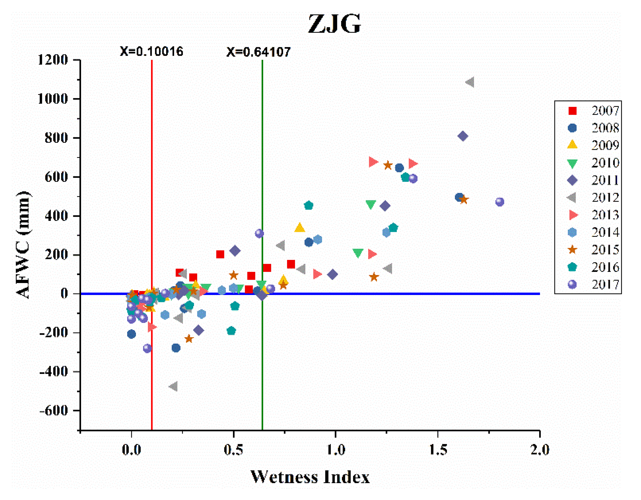
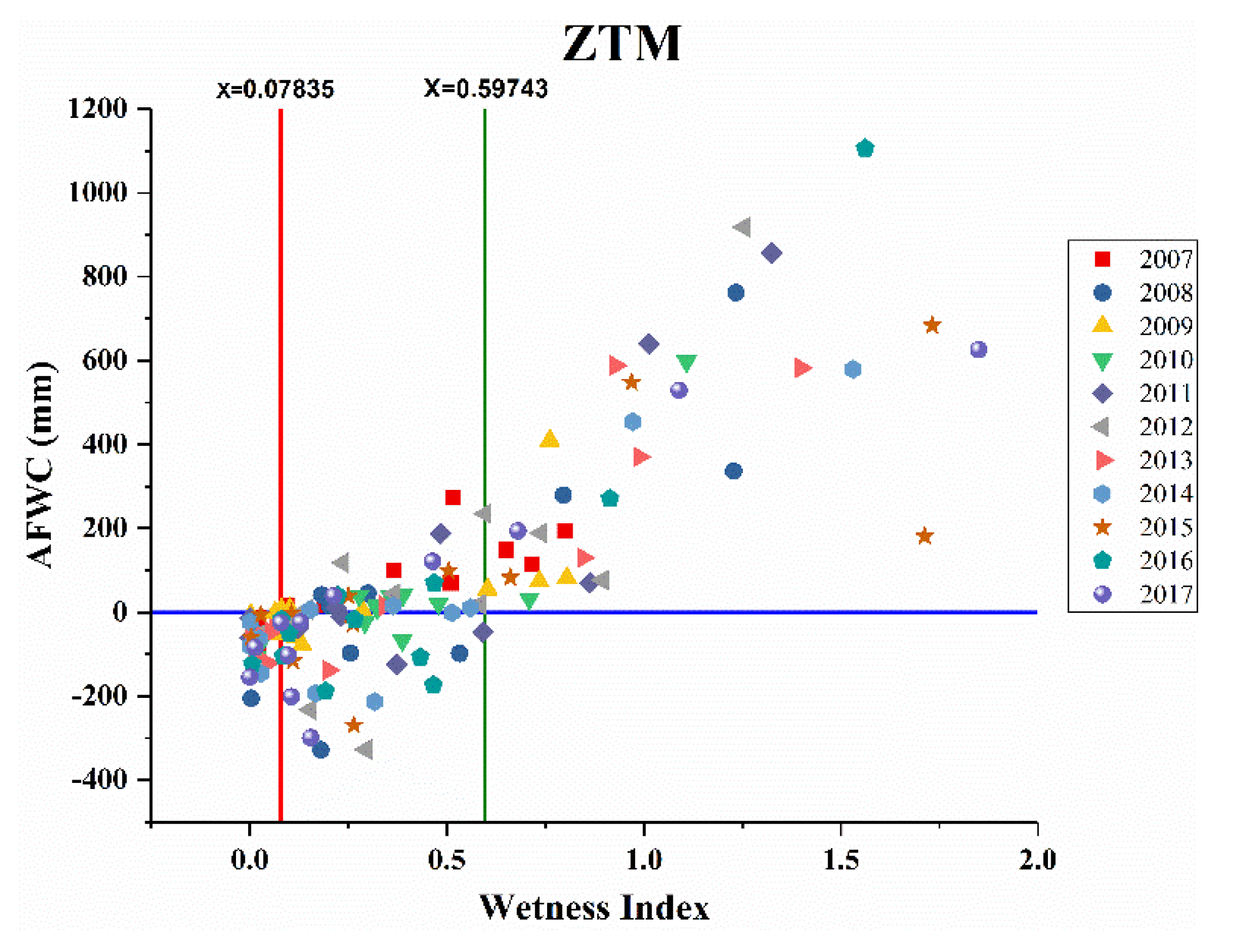
4.2.2. Monthly Scale
5. Conclusions
- (1)
- The constructed SWAT model of the three upstream basins in Xiong’an New Area has high accuracy, and the calculation formula of AFWC was suitable for the multitemporal scale analysis on AFWC in the semiarid mountains area.
- (2)
- On an annual scale, the forests in the ZJG and ZTM basins mainly played a role in storing precipitation. While AFWC in the FP basin was negative in 2009, 2013, 2014 and 2017, indicating the forests in this basin were in a state of water deficit during these four years. On a monthly scale, the positive values of AFWC mainly appeared in June to September, and the negative values of AFWC mainly appeared in December to March. On a daily scale, the forests played a role in flood interception during extreme precipitation, while the effect of forest water consumption during extreme droughts was obvious.
- (3)
- Compared with the annual AFWC, the monthly AFWC in the ZJG, ZTM and FP basins were more affected by climate change. In the three basins, the FP basin needs more humid climate conditions than the ZJG and ZTM basins to make the forests store water and keep the forests in a stable water storage state on a monthly scale.
Author Contributions
Funding
Institutional Review Board Statement
Informed Consent Statement
Acknowledgments
Conflicts of Interest
References
- Immerzeel, W.W.; Lutz, A.F.; Andrade, M.; Bahl, A.; Biemans, H.; Bolch, T.; Hyde, S.; Brumby, S.; Davies, B.J.; Elmore, A.C.; et al. Importance and vulnerability of the world’s water towers. Nature 2020, 577, 364–369. [Google Scholar] [CrossRef] [PubMed]
- Cao, W.; Wu, D.; Huang, L.; Liu, L. Spatial and temporal variations and significance identification of ecosystem services in the Sanjiangyuan National Park, China. Sci. Rep. 2020, 10, 6151. [Google Scholar] [CrossRef] [PubMed]
- Hering, J.G.; Ingold, K.M. Water Resources Management: What Should Be Integrated? Science 2012, 336, 1234–1235. [Google Scholar] [CrossRef] [PubMed]
- Trusel, L.D.; Das, S.B.; Osman, M.B.; Evans, M.J.; Smith, B.E.; Fettweis, X.; McConnell, J.R.; Noel, B.P.Y.; van den Broeke, M.R. Nonlinear rise in Greenland runoff in response to post-industrial Arctic warming. Nature 2018, 564, 104–108. [Google Scholar] [CrossRef]
- Bloschl, G.; Kiss, A.; Viglione, A.; Barriendos, M.; Bohm, O.; Brazdil, R.; Coeur, D.; Demaree, G.; Llasat, M.C.; Macdonald, N.; et al. Current European flood-rich period exceptional compared with past 500 years. Nature 2020, 583, 560–566. [Google Scholar] [CrossRef]
- Seddon, A.W.; Macias-Fauria, M.; Long, P.R.; Benz, D.; Willis, K.J. Sensitivity of global terrestrial ecosystems to climate variability. Nature 2016, 531, 229–232. [Google Scholar] [CrossRef]
- Návar, J. Fitting rainfall interception models to forest ecosystems of Mexico. J. Hydrol. 2017, 548, 458–470. [Google Scholar] [CrossRef]
- Zhou, G.; Wei, X.; Luo, Y.; Zhang, M.; Li, Y.; Qiao, Y.; Liu, H.; Wang, C. Forest recovery and river discharge at the regional scale of Guangdong Province, China. Water Res. Res. 2010, 46, W09503. [Google Scholar] [CrossRef]
- Bonell, M.; Purandara, B.K.; Venkatesh, B.; Krishnaswamy, J.; Acharya, H.A.K.; Singh, U.V.; Jayakumar, R.; Chappell, N. The impact of forest use and reforestation on soil hydraulic conductivity in the Western Ghats of India: Implications for surface and sub-surface hydrology. J. Hydrol. 2010, 391, 47–62. [Google Scholar] [CrossRef]
- Julian, J.P.; Gardner, R.H. Land cover effects on runoff patterns in eastern Piedmont (USA) watersheds. Hydrol. Process. 2014, 28, 1525–1538. [Google Scholar] [CrossRef]
- Cao, J.; Liu, C.; Zhang, W.; Han, S. Using temperature effect on seepage variations as proxy for phenological processes of basin-scale vegetation communities. Hydrol. Process. 2013, 27, 360–366. [Google Scholar] [CrossRef]
- Fang, L.; Yi, A.; Ying, Z. The influence of silviculture investment in fixed assets on forest water conservation in China. Water Qual. Res. J. 2019, 54, 220–229. [Google Scholar]
- Kurihara, M.; Onda, Y.; Kato, H.; Loffredo, N.; Yasutaka, T.; Coppin, F. Radiocesium migration in the litter layer of different forest types in Fukushima, Japan. J. Environ. Radioact. 2018, 187, 81–89. [Google Scholar] [CrossRef] [PubMed]
- Sheng, H.; Cai, T. Influence of Rainfall on Canopy Interception in Mixed Broad-Leaved—Korean Pine Forest in Xiaoxing’an Mountains, Northeastern China. Forests 2019, 10, 248. [Google Scholar] [CrossRef]
- Davies-Barnard, T.; Valdes, P.J.; Jones, C.D.; Singarayer, J.S. Sensitivity of a coupled climate model to canopy interception capacity. Clim. Dyn. 2014, 42, 1715–1732. [Google Scholar] [CrossRef]
- Peng, H.; Zhao, C.; Feng, Z.; Xu, Z.; Wang, C.; Zhao, Y. Canopy interception by a spruce forest in the upper reach of Heihe River basin, Northwestern China. Hydrol. Process. 2014, 28, 1734–1741. [Google Scholar] [CrossRef]
- Liu, L.L.; Cao, W.; Shao, Q.Q. Water Conservation Function of Forest Ecosystem in the Southern and Borthern Pan River Watershed. Sci. Geogr. Sin. 2016, 36, 603–611. [Google Scholar]
- Tang, Y.Z.; Shao, Q.Q. Dataset of Water Conservation of Forest Ecosystem in the Upper Reaches of Wujiang River, China. J. Glob. Change Data Discov. 2018, 2, 433–441. [Google Scholar]
- Zhang, B.; Li, W.H.; Xie, G.D.; Xiao, Y. Water conservation function and its measurement methods of forest ecosystem. Chin. J. Ecol. 2009, 28, 529–534. [Google Scholar]
- Na, L.; Na, R.; Zhang, J.; Tong, S.; Shan, Y.; Ying, H.; Li, X.; Bao, Y. Vegetation Dynamics and Diverse Responses to Extreme Climate Events in Different Vegetation Types of Inner Mongolia. Atmosphere 2018, 9, 394. [Google Scholar] [CrossRef]
- Xie, H.; Kung, C.-C.; Zhao, Y. Spatial disparities of regional forest land change based on ESDA and GIS at the county level in Beijing-Tianjin-Hebei area. Front. Earth Sci. 2012, 6, 445–452. [Google Scholar] [CrossRef]
- Ding, C.; Zhang, H.; Li, X.; Li, W.; Gao, Y. Quantitative assessment of water conservation function of the natural spruce forest in the central Tianshang Mountains: A case study of the Urumqi River Basin. Acta Ecol. Sin. 2017, 37, 3733–3743. [Google Scholar]
- Zeng, L.; Li, J. A Bayesian belief network approach for mapping water conservation ecosystem service optimization region. J. Geogr. Sci. 2019, 29, 1021–1038. [Google Scholar] [CrossRef]
- Cong, W.; Sun, X.; Guo, H.; Shan, R. Comparison of the SWAT and InVEST models to determine hydrological ecosystem service spatial patterns, priorities and trade-offs in a complex basin. Ecol. Indic. 2020, 112, 106089. [Google Scholar] [CrossRef]
- Yang, D.; Liu, W.; Tang, L.; Chen, L.; Li, X.; Xu, X. Estimation of water provision service for monsoon catchments of South China: Applicability of the InVEST model. Landsc. Urban Plan. 2019, 182, 133–143. [Google Scholar] [CrossRef]
- Scordo, F.; Lavender, T.; Seitz, C.; Perillo, V.; Rusak, J.; Piccolo, M.; Perillo, G. Modeling Water Yield: Assessing the Role of Site and Region-Specific Attributes in Determining Model Performance of the InVEST Seasonal Water Yield Model. Water 2018, 10, 1496. [Google Scholar] [CrossRef]
- Xu, J.; Ji, G.; Meadows, M.E.; Chen, R.; Yang, X. Modelling water yield with the InVEST model in a data scarce region of northwest China. Water Supply 2020, 20, 1035–1045. [Google Scholar]
- Zhang, D.-D.; Yan, D.-H.; Wang, Y.-C.; Lu, F.; Liu, S.-H. GAMLSS-based nonstationary modeling of extreme precipitation in Beijing–Tianjin–Hebei region of China. Nat. Hazards 2015, 77, 1037–1053. [Google Scholar] [CrossRef]
- Lin, B.; Chen, X.; Yao, H.; Chen, Y.; Liu, M.; Gao, L.; James, A. Analyses of landuse change impacts on catchment runoff using different time indicators based on SWAT model. Ecol. Indic. 2015, 58, 55–63. [Google Scholar] [CrossRef]
- Shirazi, Z.; Guo, H.; Chen, F.; Yu, B.; Li, B. Assessing the impact of climatic parameters and their inter-annual seasonal variability on fire activity using time series satellite products in South China (2001–2014). Nat. Hazards 2016, 85, 1393–1416. [Google Scholar] [CrossRef]
- Zhang, Q.; Zeng, J.; Yue, P.; Zhang, L.; Wang, S.; Wang, R. On the land-atmosphere interaction in the summer monsoon transition zone in East Asia. Theor. Appl. Clim. 2020, 141, 1165–1180. [Google Scholar] [CrossRef]
- Tan, M.L.; Gassman, P.W.; Yang, X.; Haywood, J. A review of SWAT applications, performance and future needs for simulation of hydro-climatic extremes. Adv. Water Res. 2020, 143, 103662. [Google Scholar] [CrossRef]
- Troin, M.; Caya, D. Evaluating the SWAT’s snow hydrology over a Northern Quebec watershed. Hydrol. Process. 2014, 28, 1858–1873. [Google Scholar] [CrossRef]
- Hoang, L.; Schneiderman, E.M.; Moore, K.E.B.; Mukundan, R.; Owens, E.M.; Steenhuis, T.S. Predicting saturation-excess runoff distribution with a lumped hillslope model: SWAT-HS. Hydrol. Process. 2017, 31, 2226–2243. [Google Scholar] [CrossRef]
- Rathjens, H.; Oppelt, N. SWATgrid: An interface for setting up SWAT in a grid-based discretization scheme. Comput. Geosci. 2012, 45, 161–167. [Google Scholar] [CrossRef]
- Yang, Q.; Almendinger, J.E.; Zhang, X.; Huang, M.; Chen, X.; Leng, G.; Zhou, Y.; Zhao, K.; Asrar, G.R.; Srinivasan, R.; et al. Enhancing SWAT simulation of forest ecosystems for water resource assessment: A case study in the St. Croix River basin. Ecol. Eng. 2018, 120, 422–431. [Google Scholar] [CrossRef]
- Yang, Q.; Zhang, X.; Almendinger, J.E.; Huang, M.; Leng, G.; Zhou, Y.; Zhao, K.; Asrar, G.R.; Li, X.; Qiu, J. Improving the SWAT forest module for enhancing water resource projections: A case study in the St. Croix River Basin. Hydrol. Process. 2018, 33, 864–875. [Google Scholar] [CrossRef]
- Lin, F.; Chen, X.W.; Yao, W.Y.; Fang, Y.H.; Deng, H.J.; Wu, J.F.; Lin, B.Q. Multi-time scale analysis of water conservation in a discontinuous forest watershed based on SWAT model. Acta Geogr. Sin. 2020, 75, 1065–1078. [Google Scholar]
- Cui, H.; Xiao, W.; Zhou, Y.; Hou, B.; Lu, F.; Pei, M. Spatial and Temporal Variations in Vegetation Cover and Responses to Climatic Variables in the Daqing River Basin, North China. J. Coast. Res. 2019, 93, 450. [Google Scholar] [CrossRef]
- Zhao, G.; Zhou, H.; Liu, X.; Li, K.; Zhang, P.; Wen, W.; Yu, Y. PHAHs in 14 principal river sediments from Hai River basin, China. Sci. Total Environ. 2012, 427–428, 139–145. [Google Scholar] [CrossRef]
- Sun, C.; Ren, L. Assessment of surface water resources and evapotranspiration in the Haihe River basin of China using SWAT model. Hydrol. Process. 2013, 27, 1200–1222. [Google Scholar] [CrossRef]
- Zhang, X.; Ren, L.; Kong, X. Estimating spatiotemporal variability and sustainability of shallow groundwater in a well-irrigated plain of the Haihe River basin using SWAT model. J. Hydrol. 2016, 541, 1221–1240. [Google Scholar] [CrossRef]
- Xu, H.; Wang, M.; Shi, T.; Guan, H.; Fang, C.; Lin, Z. Prediction of ecological effects of potential population and impervious surface increases using a remote sensing based ecological index (RSEI). Ecol. Indic. 2018, 93, 730–740. [Google Scholar] [CrossRef]
- Wang, Z.; Cao, J.; Zhu, C.; Yang, H. The Impact of Land Use Change on Ecosystem Service Value in the Upstream of Xiong’an New Area. Sustainability 2020, 12, 5707. [Google Scholar] [CrossRef]
- Hu, J.; Lv, Y.H.; Zhang, K.; Tao, Y.Z.; Li, T.; Ren, Y. The differences of water conservation function under typical vegetation types in the Pailugou catchment, Qilian Mountain, northwest China. Acta Ecol. Sin. 2016, 36, 3338–3349. [Google Scholar]
- Wang, S.; Fu, B.; Gao, G.; Liu, Y.; Zhou, J. Responses of soil moisture in different land cover types to rainfall events in a re-vegetation catchment area of the Loess Plateau, China. Catena 2013, 101, 122–128. [Google Scholar] [CrossRef]
- Moriasi, D.N.; Arnold, J.G.; Van Liew, M.W.; Bingner, R.L.; Harmel, R.D.; Veith, T.L. Model evaluation guidelines for systematic quantification of accuracy in watershed simulations. Trans. ASABE 2007, 50, 885–900. [Google Scholar] [CrossRef]
- Arnold, J.G.; Srinivasan, R.; Muttiah, R.S.; Williams, J.R. Large Area Hydrologic Modeling and Assessment Part I: Model Development. J. Am. Water Res. Assoc. 1998, 34, 73–89. [Google Scholar] [CrossRef]
- Yang, J.; Reichert, P.; Abbaspour, K.C.; Xia, J.; Yang, H. Comparing uncertainty analysis techniques for a SWAT application to the Chaohe Basin in China. J. Hydrol. 2008, 358, 1–23. [Google Scholar] [CrossRef]
- Abbaspour, K.C.; Rouholahnejad, E.; Vaghefi, S.; Srinivasan, R.; Yang, H.; Kløve, B. A continental-scale hydrology and water quality model for Europe: Calibration and uncertainty of a high-resolution large-scale SWAT model. J. Hydrol. 2015, 524, 733–752. [Google Scholar] [CrossRef]
- Han, E.; Merwade, V.; Heathman, G.C. Implementation of surface soil moisture data assimilation with watershed scale distributed hydrological model. J. Hydrol. 2012, 416–417, 98–117. [Google Scholar] [CrossRef]
- Nash, J.E.; Sutcliffe, J.V. River flow forecasting through conceptual models part I—A discussion of principles. J. Hydrol. 1970, 10, 282–290. [Google Scholar] [CrossRef]
- Zuo, D.; Xu, Z.; Yao, W.; Jin, S.; Xiao, P.; Ran, D. Assessing the effects of changes in land use and climate on runoff and sediment yields from a watershed in the Loess Plateau of China. Sci. Total Environ. 2016, 544, 238–250. [Google Scholar] [CrossRef] [PubMed]
- Van Griensven, A.; Meixner, T.; Grunwald, S.; Bishop, T.; Diluzio, M.; Srinivasan, R. A global sensitivity analysis tool for the parameters of multi-variable catchment models. J. Hydrol. 2006, 324, 10–23. [Google Scholar] [CrossRef]
- Kang, H.; Moon, J.; Shin, Y.; Ryu, J.; Kum, D.H.; Jang, C.; Choi, J.; Kong, D.S.; Lim, K.J. Modification of SWAT auto-calibration for accurate flow estimation at all flow regimes. Paddy Water Environ. 2015, 14, 499–508. [Google Scholar] [CrossRef]
- Deng, K.; Shi, P.; Xi, G. Water conservation of forest ecosystem in the upper reaches of yangtze river and its benefits. Res. Sci. 2002, 24, 68–73. [Google Scholar]
- Nakano, H. Forest Hydrology. In Forest Hydrology; China Forestry Publishing House: Beijing, China, 1983; pp. 207–212. [Google Scholar]
- Feng, P.; Wu, J.; Li, J. Changes in flood characteristics and the flood driving mechanism in the mountainous Haihe River Basin, China. Hydrol. Sci. J. 2019, 64, 1997–2005. [Google Scholar] [CrossRef]
- Qiu, L.; Zheng, F.; Yin, R. Effects of DEM resolution and watershed subdivision on hydrological simulation in the Xingzihe watershed. Acta Ecol. Sin. 2012, 32, 3754–3763. [Google Scholar]
- Di Luzio, M.; Arnold, J.G.; Srinivasan, R. Effect of GIS data quality on small watershed stream flow and sediment simulations. Hydrol. Process. 2005, 19, 629–650. [Google Scholar] [CrossRef]
- Liang, K.; Jiang, Y.; Qi, J.; Fuller, K.; Nyiraneza, J.; Meng, F.R. Characterizing the impacts of land use on nitrate load and water yield in an agricultural watershed in Atlantic Canada. Sci. Total Environ. 2020, 729, 138793. [Google Scholar] [CrossRef]
- Patil, A.; Ramsankaran, R. Improving streamflow simulations and forecasting performance of SWAT model by assimilating remotely sensed soil moisture observations. J. Hydrol. 2017, 555, 683–696. [Google Scholar] [CrossRef]
- Jha, M.; Gassman, P.W.; Secchi, S.; Gu, R.; Arnold, J. Effect of watershed subdivision on swat flow, sediment, and nutrient predictions. J. Am. Water Res. Assoc. 2004, 40, 811–825. [Google Scholar] [CrossRef]
- Her, Y.; Frankenberger, J.; Chaubey, I.; Srinivasan, R. Threshold Effects in HRU Definition ofthe Soil and Water Assessment Tool. Trans. ASABE 2015, 58, 367–378. [Google Scholar]
- Tang, Y.; Tang, Q.; Wang, Z.; Chiew, F.H.S.; Zhang, X.; Xiao, H. Different Precipitation Elasticity of Runoff for Precipitation Increase and Decrease at Watershed Scale. J. Geophysic. Res. Atmos. 2019, 124, 11932–11943. [Google Scholar] [CrossRef]
- Zhang, F.; Li, X.; Feng, Q.; Wang, H.; Wei, Y.; Bai, H. Spatial and temporal variation of water conservation in the upper reaches of Heihe River basin based on InVEST model. J. Desert Res. 2018, 38, 1321–1329. [Google Scholar]
- Song, S.; Li, L.; Chen, X.; Bai, J. The dominant role of heavy precipitation in precipitation change despite opposite trends in west and east of northern China. Int. J. Clim. 2015, 35, 4329–4336. [Google Scholar] [CrossRef]
- Maček, U.; Bezak, N.; Šraj, M. Reference evapotranspiration changes in Slovenia, Europe. Agric. For. Meteorol. 2018, 260-261, 183–192. [Google Scholar] [CrossRef]
- Liu, L.; Wang, Z.; Wang, Y.; Zhang, Y.; Shen, J.; Qin, D.; Li, S. Trade-off analyses of multiple mountain ecosystem services along elevation, vegetation cover and precipitation gradients: A case study in the Taihang Mountains. Ecol. Indic. 2019, 103, 94–104. [Google Scholar] [CrossRef]
- Li, X.; Li, Y.; Zhang, Q.; Xu, X. Evaluating the influence of water table depth on transpiration of two vegetation communities in a lake floodplain wetland. Hydrol. Res. 2016, 47, 293–312. [Google Scholar] [CrossRef]
- Heitman, J.L.; Horton, R.; Sauer, T.J.; DeSutter, T.M. Sensible Heat Observations Reveal Soil-Water Evaporation Dynamics. J. Hydrometeorol. 2008, 9, 165–171. [Google Scholar] [CrossRef]
- Uddin, J.; Foley, J.P.; Smith, R.J.; Hancock, N.H. A new approach to estimate canopy evaporation and canopy interception capacity from evapotranspiration and sap flow measurements during and following wetting. Hydrol. Process. 2016, 30, 1757–1767. [Google Scholar] [CrossRef]
- Gavilán, P.; Castillo-Llanque, F. Estimating reference evapotranspiration with atmometers in a semiarid environment. Agric. Water Manag. 2009, 96, 465–472. [Google Scholar] [CrossRef]
- Zhou, G.; Wei, X.; Chen, X.; Zhou, P.; Liu, X.; Xiao, Y.; Sun, G.; Scott, D.F.; Zhou, S.; Han, L.; et al. Global pattern for the effect of climate and land cover on water yield. Nat. Commun. 2015, 6, 5918. [Google Scholar] [CrossRef] [PubMed]
- Hong, Y.; Yu, S.; Yang, X.; Luo, Y. Study on Spatial—Temporal Changes and Driving Factors of Water Conservation in Hengduan Mountain Region. Geomat. Spat. Inf. Technol. 2019, 42, 72–76. [Google Scholar]
- Ning, Y.; Zhang, F.; Feng, Q.; Wei, Y.; Ding, J.; Zhang, Y. Temporal and spatial variation of water conservation function in Qinling Mountain and its influencing factors. Chin. J. Ecol. 2020, 39, 3080–3091. [Google Scholar]
- Wang, X.; Shen, H.; Li, X.; Jing, F. Concepts, processes and quantification methods of the forest water conservation at the multiple scales. Acta Ecol. Sin. 2013, 33, 1019–1030. [Google Scholar] [CrossRef]


| Basins | Main Land Use Types | Main Soil Types | Average Slope |
|---|---|---|---|
| ZJG | Forest land (42.00%) | Cinnamon Soil (86.20%) | 17.75° |
| Grassland (33.83%) | |||
| ZTM | Grassland (50.20%) | Cinnamon Soil (77.56%) | 17.76° |
| Forest land (26.11%) | |||
| FP | Grassland (53.96%) | Cinnamon Soil (92.35%) | 22.25° |
| Forest land (39.40%) |
| Parameter | Description | Range |
|---|---|---|
| ALPHA_BF | Baseflow alpha factor (day) | 0–1 |
| CH_K2 | Effective hydraulic conductivity in main channel alluvium (mm/h) | −0.01–500 |
| CN2 | SCS curve number for moisture condition | −0.3–0.3 |
| ESCO | Soil evaporation compensation factor | 0.4–1 |
| SOL_K | Saturated hydraulic conductivity | −0.3–0.3 |
| GWQMN | Threshold depth of water in the shallow aquifer required for return flow to occur (mm) | 0–1500 |
| SURLAG | Surface runoff lag coefficient (day) | 0.05–24 |
| REVAPMN | Threshold depth of water in the shallow aquifer for “revap” to occur (mm) | 0–500 |
| GW_DELAY | Groundwater delay (day) | 30–450 |
| SOL_AWC | Available water capacity of the soil layer | −0.3–0.3 |
| Land Use Types | Actual Area (km2) | Generalized Area (km2) | Actual Proportion (%) | Generalized Proportion (%) | Number of HRU |
|---|---|---|---|---|---|
| Arable land | 348.42 | 349.97 | 19.91 | 20.06 | 149 |
| Forest land | 735.07 | 728.31 | 42.00 | 41.75 | 151 |
| Grassland | 592.20 | 590.95 | 33.83 | 33.88 | 153 |
| Waters | 19.06 | 19.16 | 1.09 | 1.10 | 67 |
| Construction land | 53.96 | 54.30 | 3.08 | 3.12 | 175 |
| Bare land | 1.61 | 1.62 | 0.09 | 0.09 | 7 |
| Total | 1750.32 | 1744.31 | 100.00 | 100.00 | 702 |
| Land Use Types | Actual Area (km2) | Generalized Area (km2) | Actual Proportion (%) | Generalized Proportion (%) | Number of HRU |
|---|---|---|---|---|---|
| Arable land | 681.35 | 682.79 | 20.01 | 20.11 | 333 |
| Forest land | 888.66 | 883.65 | 26.11 | 26.03 | 368 |
| Grassland | 1712.30 | 1704.57 | 50.20 | 50.21 | 402 |
| Waters | 55.78 | 56.07 | 1.64 | 1.65 | 192 |
| Construction land | 67.46 | 67.62 | 2.04 | 2.00 | 277 |
| Bare land | 0.00 | 0.00 | 0.00 | 0.00 | 0 |
| Total | 3405.55 | 3394.71 | 100.00 | 100.00 | 1572 |
| Land Use Types | Actual Area (km2) | Generalized Area (km2) | Actual Proportion (%) | Generalized Proportion (%) | Number of HRU |
|---|---|---|---|---|---|
| Arable land | 97.53 | 97.98 | 4.53 | 4.56 | 129 |
| Forest land | 848.87 | 844.79 | 39.40 | 39.32 | 199 |
| Grassland | 1162.44 | 1160.22 | 53.96 | 54.00 | 205 |
| Waters | 22.69 | 22.77 | 1.05 | 1.06 | 115 |
| Construction land | 22.78 | 22.71 | 1.06 | 1.06 | 176 |
| Bare land | 0.09 | 0.07 | 0.00 | 0.00 | 5 |
| Total | 2154.40 | 2148.54 | 100.00 | 100.00 | 829 |
| Periods | Validation Indicator | Year | Month | Day | ||||||
|---|---|---|---|---|---|---|---|---|---|---|
| ZJG | ZTM | FP | ZJG | ZTM | FP | ZJG | ZTM | FP | ||
| Calibration period (2007–2012) | NSE | 0.87 | 0.86 | 0.89 | 0.83 | 0.84 | 0.82 | 0.78 | 0.77 | 0.79 |
| R2 | 0.92 | 0.9 | 0.9 | 0.87 | 0.86 | 0.87 | 0.82 | 0.84 | 0.82 | |
| PBIAS (%) | −2.13 | 1.54 | 0.84 | 10.81 | 8.75 | −1.93 | 7.97 | 5.62 | 2.8 | |
| Validation period (2013–2017) | NSE | 0.88 | 0.85 | 0.87 | 0.82 | 0.8 | 0.81 | 0.74 | 0.78 | 0.77 |
| R2 | 0.9 | 0.88 | 0.89 | 0.84 | 0.85 | 0.85 | 0.81 | 0.82 | 0.81 | |
| PBIAS (%) | 5.1 | 8.43 | 3.3 | 5.77 | 8.4 | 4.59 | −2.8 | 4.8 | 5.9 | |
| Threshold | Area of HRU under Different Land Use (km2) | Number of HRU | |||||
|---|---|---|---|---|---|---|---|
| Arable Land | Forest Land | Grassland | Waters | Construction Land | Bare Land | ||
| T000000 | 349.97 | 728.31 | 590.95 | 19.16 | 54.30 | 1.62 | 702 |
| T011010 | 353.01 | 734.47 | 596.18 | 15.35 | 45.29 | 0.00 | 251 |
| T051010 | 370.18 | 756.23 | 615.01 | 0.36 | 2.54 | 0.00 | 184 |
| T101010 | 355.23 | 764.39 | 623.53 | 0.36 | 0.80 | 0.00 | 176 |
| T102010 | 355.23 | 764.39 | 623.53 | 0.36 | 0.80 | 0.00 | 105 |
| T102020 | 355.23 | 764.39 | 623.53 | 0.36 | 0.80 | 0.00 | 86 |
| Threshold | Area of HRU Under Different Land Use (km2) | Number of HRU | |||||
|---|---|---|---|---|---|---|---|
| Arable Land | Forest Land | Grassland | Waters | Construction Land | Bare Land | ||
| T000000 | 682.79 | 883.65 | 1704.57 | 56.07 | 67.62 | 0.00 | 1572 |
| T011010 | 686.98 | 887.90 | 1712.81 | 52.70 | 54.32 | 0.00 | 576 |
| T051010 | 679.90 | 913.57 | 1779.09 | 0.58 | 21.57 | 0.00 | 431 |
| T101010 | 622.70 | 937.57 | 1826.80 | 0.00 | 7.64 | 0.00 | 385 |
| T102010 | 622.70 | 937.57 | 1826.80 | 0.00 | 7.64 | 0.00 | 226 |
| T102020 | 622.70 | 937.57 | 1826.80 | 0.00 | 7.64 | 0.00 | 181 |
| Threshold | Area of HRU under Different Land Use (km2) | Number of HRU | |||||
|---|---|---|---|---|---|---|---|
| Arable Land | Forest Land | Grassland | Waters | Construction Land | Bare Land | ||
| T000000 | 97.98 | 844.79 | 1160.22 | 22.77 | 22.71 | 0.07 | 829 |
| T011010 | 96.89 | 851.68 | 1168.81 | 17.08 | 14.09 | 0.00 | 303 |
| T051010 | 88.23 | 871.35 | 1188.23 | 0.70 | 0.03 | 0.00 | 210 |
| T101010 | 3.04 | 900.67 | 1244.10 | 0.70 | 0.03 | 0.00 | 175 |
| T102010 | 3.04 | 900.67 | 1244.10 | 0.70 | 0.03 | 0.00 | 112 |
| T102020 | 3.04 | 900.67 | 1244.10 | 0.70 | 0.03 | 0.00 | 79 |
Publisher’s Note: MDPI stays neutral with regard to jurisdictional claims in published maps and institutional affiliations. |
© 2021 by the authors. Licensee MDPI, Basel, Switzerland. This article is an open access article distributed under the terms and conditions of the Creative Commons Attribution (CC BY) license (http://creativecommons.org/licenses/by/4.0/).
Share and Cite
Wang, Z.; Cao, J.; Yang, H. Multi-Time Scale Evaluation of Forest Water Conservation Function in the Semiarid Mountains Area. Forests 2021, 12, 116. https://doi.org/10.3390/f12020116
Wang Z, Cao J, Yang H. Multi-Time Scale Evaluation of Forest Water Conservation Function in the Semiarid Mountains Area. Forests. 2021; 12(2):116. https://doi.org/10.3390/f12020116
Chicago/Turabian StyleWang, Zhiyin, Jiansheng Cao, and Hui Yang. 2021. "Multi-Time Scale Evaluation of Forest Water Conservation Function in the Semiarid Mountains Area" Forests 12, no. 2: 116. https://doi.org/10.3390/f12020116
APA StyleWang, Z., Cao, J., & Yang, H. (2021). Multi-Time Scale Evaluation of Forest Water Conservation Function in the Semiarid Mountains Area. Forests, 12(2), 116. https://doi.org/10.3390/f12020116