Article

Cross-Cultural Leadership Enables Collaborative Approaches to Management of Kauri Dieback in Aotearoa New Zealand

1
BioSense Limited, 27 Barrys Point Road, Takapuna, Auckland 0622, New Zealand
2
Te Kawerau ā Maki, 3 Airpark Drive, Māngere, Auckland 2022, New Zealand
3
Plant & Food Research, 120 Mount Albert Road, Mount Albert, Sandringham, Auckland 1025, New Zealand
4
Auckland Botanic Gardens, 102 Hill Road, The Gardens, Auckland 2105, New Zealand
*
Author to whom correspondence should be addressed.
Forests 2021, 12(12), 1671; https://doi.org/10.3390/f12121671
Submission received: 17 August 2021 / Revised: 8 November 2021 / Accepted: 17 November 2021 / Published: 30 November 2021

Abstract

:
In Aotearoa/New Zealand, the soilborne pathogen Phytophthora agathidicida threatens the survival of the iconic kauri, and the ecosystem it supports. In 2011, a surveillance project to identify areas of kauri dieback caused by Phytophthora agathidicida within the Waitākere Ranges Regional Park (WRRP) highlighted the potential impact of the pathogen. A repeat of the surveillance in 2015/16 identified that approximately a quarter of the kauri area within the Regional Park was infected or possibly infected, an increase from previous surveys. The surveillance program mapped 344 distinct kauri areas and showed that 33.4% of the total kauri areas were affected or potentially affected by kauri dieback and over half (58.3%) of the substantial kauri areas (above 5 ha in size) were showing symptoms of kauri dieback. Proximity analysis showed 71% of kauri dieback zones to be within 50 m of the track network. Spatial analysis showed significantly higher proportions of disease presence along the track network compared to randomly generated theoretical track networks. Results suggest that human interaction is assisting the transfer of Phytophthora agathidicida within the area. The surveillance helped trigger the declaration of a cultural ban (rāhui) on recreational access. Te Kawerau ā Maki, the iwi of the area, placed a rāhui over the kauri forest eco-system of the Waitākere Forest (Te Wao Nui o Tiriwa) in December 2017. The purpose of the rāhui was to help prevent the anthropogenic spread of kauri dieback, to provide time for investment to be made into a degraded forest infrastructure and for research to be undertaken, and to help protect and support forest health (a concept encapsulated by the term mauri). Managing the spread and impact of the pathogen remains an urgent priority for this foundation species in the face of increasing pressures for recreational access. Complimentary quantitative and qualitative research programs into track utilization and ecologically sensitive design, collection of whakapapa seed from healthy and dying trees, and remedial phosphite treatments are part of the cross-cultural and community-enabled biosecurity initiatives to Kia Toitu He Kauri “Keep Kauri Standing”.

1. Introduction

Tāne Mahuta, a Kauri (Agathis australis), is central to the Māori creation myth, separating his parents Ranginui (the sky father) and Papatūānuku (the earth mother), creating light and allowing life to exist and prosper [1]. Kauri has a long geological history and is of cultural significance to the indigenous Māori people. Many hapū and iwi (kin-groups who originate in and hold customary authority over a geographic area) have strong cultural linkages with kauri and consider kauri a taonga or treasured iconic species, and an intrinsic part of their cultural fabric. Hapū and iwi are the kaitiaki or guardians of the kauri and have been recognized as essential partners in the long-term management of kauri in the face of past ecological disturbances (logging, gum-tapping, and burn-off to create agricultural land), pest-animal pressures (pigs and possums), recreational demands (track networks) and climate disruption. Hapū and iwi have, over centuries of living off the whenua (land), developed a body of culturally encoded Mātauranga (knowledge) and customs tikanga (customs) related to monitoring and managing environmental health, including that of kauri forest.
Agathis australis, a member of the Araucariaceae family, has been important in shaping Aotearoa/New Zealand since the islands separated from Gondwana some 85 million years ago [2]. Ecologically, kauri is a keystone species supporting a unique indigenous ecosystem and biodiversity [3]. Kauri ecosystems are created from distinct flora communities and form the most species-rich forest type in NZ [4], averaging 18 tree species per hectare including many endemics [5]. Kauri and its associates form a unique forest type with some species, such as the greenhood orchid Pterostylis agathicola, found only in association with kauri [6]. Kauri is one of the largest and long-lived tree species in Aotearoa/New Zealand forests [7] and one of the largest trees in the world by volume. Their size and longevity allow mature trees, with wide-spanning canopies, to support a diverse and highly populated array of epiphytes. Initial surveys of large kauri report over 47 vascular plant species living within the canopy, with many more Bryophytes and Pteridophytes noted, creating unique treetop islands of biodiversity. Diversity and uniqueness is also seen in the fungal communities of kauri ecosystems. A total of 189 named species of fungi and 75 unidentified species, distributed within 199 genera, have been recorded on kauri in New Zealand [8]. Arbuscular mycorrhizal fungi are present within kauri roots, with some species uniquely associated with kauri [9]. Kauri produce deep mounds of leaf litter [10] that have a significant influence on soil processes beneath its canopies, reducing soil pH, stalling nitrogen cycling processes, and sometimes forming podzols [11]. An inevitable conclusion from the importance of kauri to these ecosystems is that if kauri were to be removed from them, the species dependent on that environment could also be lost [12].
At the time of European settlement, forests containing kauri covered 1,000,000 ha or more. Following uncontrolled logging, land clearance for alternative land use and destruction by fire, only 7500 ha of virgin or primary forest remain, mainly in conservation reserves. An additional 60,000 ha of scrub/shrubland and secondary forest contain varying amounts of regenerating kauri [13]. These remaining kauri forests are now under threat from disease.
Kauri dieback disease is caused by a soil and water-borne primary pathogen of New Zealand kauri. The causal agent was tag-named Phytophthora taxon Agathis (PTA) when it was discovered in 2008 [14]. After broader regional surveys, collection of a sample of isolates from kauri forests enabled the formal description of the “kauri-killing” Phytophthora, “Phytophthora agathidicida”, belonging to Phytophthora Clade 5 together with P. castaneae (sweet chestnut), P. heveae (plantation rubber) and P. cocois (coconut pod rot) [15]. Initial infection and early symptoms of kauri fine feeder root infection are both cryptic and currently difficult to detect. The above-ground symptoms of kauri dieback infection include yellowing of the leaves, thinning of the canopy and lesions or cankers on the lower stem, which often encircle the base and produce copious amounts of resin (so-called “kauri gum”). Other symptoms include damping off and wilt of seedlings, root rot and underground lesions of roots. Such symptoms are considered mid to late-onset reactions to infection [16]. Pathogenicity assays have shown Phytophthora agathidicida to be an extremely aggressive and virulent pathogen of kauri that can rapidly kill seedlings [17] and trees of all ages [18] and therefore poses a threat to kauri, the kauri ecosystem, and the species reliant on it.
Declining kauri formally associated with what we now call ‘kauri dieback’ were first reported in a stand of kauri on Aotea/Great Barrier Island, an island in the outer Hauraki Gulf, 100 km north-east of central Auckland [19]. Additional forensic investigation of forestry, nursery, and plantation information has indicated that the pathogen may have been responsible for historic largescale kauri losses [20], however there are no subsequent records until investigation of declining stands of kauri in the Waitākere Ranges, Auckland in 2005. Between 2005 and 2010, kauri dieback was confirmed in other public forest reserves in Auckland and Northland, including Albany, Pakiri, Waipoua Forest, Trounson Kauri Park, Omahuta and Raetea Forest [21]. Ongoing surveillance has shown the pathogen to be widespread across the range of kauri forests [22], with significant detections such as isolation of Phytophthora agathidicida from soil within 60 m of Tāne Mahuta, known by Māori as God of the forest and birds [23]. However, substantial asymptomatic areas of kauri remain.
Soilborne Phytophthora species can survive adverse environmental conditions with enduring resting structures, mainly sexual oospores, vegetative chlamydospores and hyphal aggregations [24], allowing spread by human activities. Native plant communities, woodlands and landscapes across the world are suffering from pathogens introduced by human activities [25]. Phytophthora agathidicida has been isolated from soil taken from hiking boots being worn by visitors, soil and slurry taken from boot cleaning stations, and from soil and debris taken from the exterior of vehicles [26]. One other vector of spread of Phytophthora is through waterways. Internationally studies have shown water to be a significant disperser of spores and hyphae [27,28,29]. The extent to which this occurs in New Zealand has not been documented, mainly due to a previous lack of tools for detection of Phytophthora agathidicida in water. After this study Phytophthora agathidicida has been detected within watercourses [30], however research into the quantification and distribution has not yet occurred.
In 2008, the Ministry for Primary Industries declared Phytophthora agathidicida an ‘Unwanted Organism’ under New Zealand’s Biosecurity Act, making it an offence to breed, knowingly communicate, exhibit, multiply, propagate, release, or sell the organism unless permission is obtained from a chief technical officer. A biosecurity response was initiated by the Ministry for Primary Industries, Tangata Whenua (local Māori), Department of Conservation and Local Authorities (Regional Councils) within the natural range of kauri. Initial focus of the response was on identifying the distribution of the disease, establishing containment and hygiene measures, providing education and awareness tools to communities, and research to understand and manage the disease. While the response achieved some success, resistance, and a general lack of recognition of indigenous knowledge by some forestry managers and agencies has been reported [31].
Internationally, there is growing recognition of the need for and importance of indigenous knowledge in environmental management and protection [32,33,34,35]. With the contribution and knowledge of indigenous people being widely accepted as critical to biodiversity and ecosystem management [36]. The inextricable and interdependent relationship between people and nature forms the foundation for the organization of indigenous knowledge and this embedded-in-nature relationship has led to a body of dynamic intergenerational awareness and practice that operates within indigenous worldviews and belief systems [37]. Mātauranga Māori, a knowledge system incorporating Māori philosophical thought, worldview and practice, provides important insight and practice and is vital for understanding and managing Aotearoa/New Zealand’s ecosystems [38]. Rāhui is a Māori ritual prohibition which aims to separate people from tapu (sacred) things [39]. After an agreed lapse of time, the rāhui is lifted. A rāhui is often marked by a visible sign, such as the erection of a pou rāhui, a post. It is initiated by someone of rank and placed and lifted with appropriate karakia or ritual ceremony by a tohunga or tribal elder. A rāhui may be placed on land, sea, rivers, forests, gardens, fishing grounds, and other food resources. There were three original uses of rāhui, these were following the loss of life, to claim ownership, and for replenishing resources. A rāhui for replenishment of resources is a form of Kaitiakitanga (guardianship) whereby, “Man, as the conscious mind of Papatūānuku prohibits the exploitation, denudation, degeneration and pollution of the environment and its resources beyond the point of no return where the latent pro-life processes within the biological functions and ecosystems collapse” [40]. Rāhui over resources are installed to allow the mauri (life essence) to replenish, with mauri being described as ‘Mauri ora’, a life force. All animate and other forms of life such as plants and trees owe their continued existence and health to mauri. When the mauri is strong, fauna and flora flourish. When it is depleted and weak to those forms of life, they become sickly and weak [40]. Māori have adapted the custom to suit New Zealand’s changing social environment and consequently rāhui have evolved in purpose, method and even by the taonga (treasured object) they are used to protect [41], however the drivers of respect, healing, replenishment, and protection are constant. Therefore, we see the current example of rāhui being implemented as part of a cross-cultural approach to manage the health of kauri forests in the wake of an aggressive pathogen, likely being spread by human activities.
To inform management of Phytophthora agathidicida across kauri areas within the Waitākere Ranges Regional Park (WRRP), a multi-layered, cross-cultural, inter-generational approach was adopted to utilize current understanding of the disease and host to map the distribution of kauri dieback. Surveillance was conducted over the 2015/16 summer period following methodologies like those conducted in 2010 [42]. The aims of the work were (1) to provide an evidential basis of pathogen distribution for decision making; and (2) to enable recreation and conservation objectives to be achieved within a framework of tikanga, biosecurity and risk-based management and mitigation. Here we describe a scientific evaluation of the distribution of the pathogeny. In the discussion we address how such information was used to inform decision-making and to normalize the management and control regimes within the broader community. We then describe strategies beyond rāhui that are currently being undertaken to further manage this pathogen.

2. Materials and Methods

Disease surveillance was required to provide evidence-based modelling of pathogen distribution to inform disease management decisions. Surveillance followed four phases (1) aerial surveillance to identify kauri exhibiting canopy decline, (2) ground-truthing to survey for kauri dieback symptoms and collect samples for analysis, (3) bioassay of samples to determine the presence of Phytophthora agathidicida, and (4) mapping of disease.

2.1. Study Site

The Waitākere Ranges (part of a remnant volcanic landform) are the western visual backdrop to metropolitan Auckland. Their forested hills and coastal vistas are essential to the identity of both Waitākere City and metropolitan Auckland. The foothills and coastal areas are a combination of rural, urban, and natural landscapes that create an important transition and buffer zone to the forested part of the Ranges. The area has a long and rich human history. It is a distinctive cultural domain for Māori and lies within the rohe (territory) of both Te Kawerau ā Maki and Ngāti Whātua. The area includes the Waitākere Ranges Regional Park (WRRP).
The forest that covers the Waitākere Ranges is known to Te Kawerau ā Maki as Te Wao Nui o Tiriwa and the area is considered the heartland of the iwi. The tribe has occupied and maintained the area for some 400 years, although it traces its ancestors back even further to the creation narratives of the area. Te Kawerau ā Maki maintained kāinga (villages) and (fortified settlements and outposts) along the coastal and riverine edges of the forest, and carefully utilized its resources to provide kai (food), rongoā (medicine), textiles and timber in a seasonal cycle of resource gathering. These activities were undertaken in accordance with tikanga and relied upon mātauranga, forming an indigenous system of environmental management. Such a system by nature had to be sustainable as survival of the iwi depended upon being able to successfully navigate the environment and ensure resources remained for the next harvest season and for future generations. In addition, Te Kawerau ā Maki consider kauri specifically to be part of their whakapapa (genealogy) based on Māori cosmology, an important conduit between the physical and spiritual realms, and a rangatira (chief) of the forest. For all these reasons Te Kawerau ā Maki see the survival of kauri and the Waitākere forest as an existential matter for the tribe.
The Waitākere Ranges Regional Park (WRRP) is protected at local, regional, and national levels, and is an area of some 17,000 ha, established over a period of 110 years through gifts, grants, purchases, and vestings (including legislation promoted by Auckland City Council in 1941 to create the Auckland Centennial Memorial Park). The WRRP covers more than 16,000 ha of native forest. Kauri is found throughout the WRRP as either dominant patches, codominant or mixed with other conifers and broadleaf species as well as young ricker stands in early successional shrubland. Kauri forest, where Agathis australis is the dominant species, is often found on ridges but is not the exclusive forest type on this habitat, nor is it always found on ridges. It is clear it is much reduced from its former extent after a century of logging in the Ranges. The Auckland Protection Strategy [43] identifies that just 14% (1675 ha) of the former kauri forests of the Waitākere Ecological District remain. A further 10,670 ha remains where kauri is present mixed with tanekaha (Phyllocladus trichomanoides), rimu (Dacrydium cupressinum), kanuka (Kunzea robusta) and broadleaf species. There are some patches of unmodified kauri forest, for example at the Cascades [44], but much of the kauri forest in the WRRP is secondary forest that has returned after forest clearance and logging. The area represents a strong recreational focus for local and international tourism with a network of over 256 km of tracks and approximately 1,000,000 visitors per year.

2.2. Aerial Surveillance

High-resolution photos and GPS coordinates generated by a systematic helicopter-based aerial survey of kauri canopy health across the entire park, following previously described methods [45], recognised 304 sites that were identified as a tree, trees, or groups of trees potentially exhibiting kauri dieback symptoms [46]. All 304 sites were inspected by ground-based surveillance to further assess kauri dieback symptomology.

2.3. Ground Surveillance

A strategic surveillance method was developed to prioritize and delineate kauri dieback at the site by recording the extent of kauri exhibiting symptoms of disease. A survey at a site was carried out along a spiral transect, moving from kauri to kauri (skipping those within 5 m of a previously surveyed tree), until no further symptomatic kauri tree could be found within 30 m of the previous tree. The final kauri exhibiting symptoms at the edge of the site was always recorded to accurately map the extent of symptomology. Surveillance was carried out following this method in all areas except for the Piha catchment where the area of symptomology was so large, approximately 80 ha based on aerial surveillance and initial ground inspection, that an optimized methodology was adopted which involved moving along transects. At this site linear transects were established at 20 m intervals along contours. Kauri trees 10 m either side of the transect were inspected, and the same set of meta-data collected.
All kauri off tracks which were on route to the sites were also visually assessed for kauri dieback symptoms and trees exhibiting symptoms were recorded. Similarly, all kauri along the tracks (within 10 m of the track) were also visually assessed for kauri dieback symptoms but in this case both symptomatic and non-symptomatic kauri were recorded. This was so that individual kauri along the track network were geospatially tagged to inform future park management about actions such as track upgrades.
Symptomology data captured for each kauri included a canopy health score (1–healthy to 5–dead), a canopy photo, basal lesion size and activity, a photograph of the basal lesion and the surveyor’s conclusion on the kauri dieback status of the tree based on visible expression of symptoms described. To greater inform the metrics of health, surveyors noted the presence or absence of symbiotic plant and fungi taxa within kauri ecosystems, the abundance or lack of abundance of customary harvest species, the visual health of customary harvest species and supporting taxa, the presence or absence of certain birds and animals including birdsong, and metaphysical indicators relating to the wairua (spirit) and mauri (sense of lifeforce) of the forest and tūpuna (ancestors). These other indicators were used to weight decision-making about rāhui and other management decisions as part of a cross-cultural decision-making framework (and see Section 4).

2.4. Sampling for Phytophthora Agathidicida Presence

At sites of possible kauri dieback infection, a candidate tree, or trees most likely to be infected with Phytophthora agathidicida, based on symptomology, was selected and sampled. The most symptomatic live kauri based on canopy health and basal lesion activity at a site was chosen as the preferred point for soil sampling. At sites where the only symptomatic tree or trees were all dead, dead trees were sampled. Soil samples were taken from four positions around the base of the tree. Samples were taken between 60 cm and 150 cm of the trunk. A sub-sample was always taken from the side of the tree with the most active bleed first, followed by three subsequent sub-samples at each of the corresponding cardinal points around the trunk. The samples were from the surface to a depth of 20 cm. Each sub-sample was approx. 250 g.
Confirmation of kauri dieback was based on bioassay of soil samples collected from sites. Analysis of Phytophthora agathidicida presence was carried out by Plant and Food Research Limited using the established standard operating protocol for Phytophthora agathidicida detection. The standard bioassay process involves drying, wetting, and flooding of 250 g soil samples. Plant baits, e.g., lupin radicles or needles of Himalayan Cedar Cedrus deodora, are floated on the water for 2 days and then removed and plated to Phytophthora-selective media. Plates are assessed qualitatively for the presence of characteristic oospores of P. agathidicida being produced on the media plate.

2.5. Mapping

ArcGIS was used to create defined zones of kauri dieback from expression-based data captured during aerial and ground surveillance. Point data from individual kauri locations was enhanced into spatially representative polygons of kauri dieback distribution using estimated rootzones of the kauri trees based on diameter at breast height (DBH) plus a buffer of potential Phytophthora agathidicida presence within the surrounding soil. Kauri dieback status was classified based on symptomology expressed and results from soil bioassay (Table 1).
False positives in the soil samples are possible as, even though the sampling method was targeted, only a small amount of soil was taken for analysis, especially when compared to the large potential area of pathogen presence within the trees rootzone. In addition, the efficacy of the bioassay was also unknown. Therefore, to acknowledge potential false negative sample results, and the cryptic nature of early symptomology, a category of ‘Possible kauri dieback zone’ was used. As the results were to be used to inform disease management activities this was an important category between known kauri dieback area that formed ‘Kauri dieback zones’ and areas where kauri dieback was much less likely based on surveillance, ‘Non-symptomatic kauri zones’.

2.6. Track Analysis

With the track network being identified as a potential vector pathway, further analysis to evaluate this factor was undertaken. Ten simulated track networks of the same length as the actual track network were created at random using ArcGIS. For each track, the distance of that track through either a kauri dieback zone, possible kauri dieback zone or non-symptomatic kauri zone was calculated (see Figure 1). This was then repeated for the 10 simulated tracks to test whether Kauri dieback was more prevalent along real tracks than would be expected by sampling at random.
This analysis was undertaken to provide a statistical comparison between the distribution of kauri and kauri dieback along tracks with a randomised simulated control. We were interested in two key hypotheses:
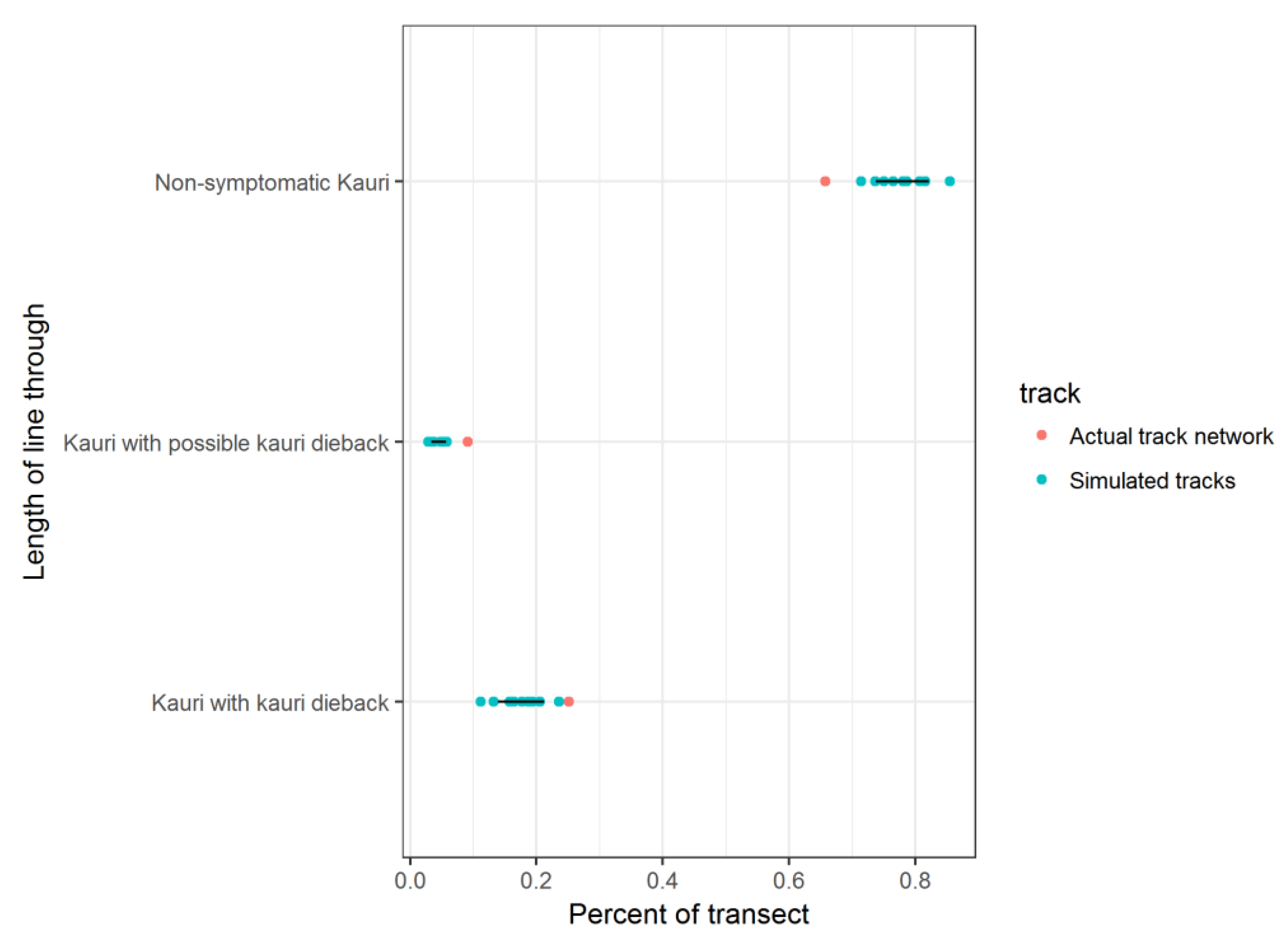
  • The actual track network of the WRRP intersects a greater amount of kauri than a randomly generated track.
  • The actual track network has a higher percentage of kauri dieback along it than the randomly generated track.
For the 10 simulated tracks the mean line length in each zone and the mean percent of kauri for each transect was calculated. Ninety-nine percent confidence intervals were also calculated. The 99% CIs of the randomised tracks were compared back to the actual track values. If we sampled different transects along the forest 100 times, we would expect that 99 times out of 100 the value would lie within that interval. If the values of the actual tracks lie outside the range, the possibility that this is due to chance is extremely low, i.e., less than 1 out of 100.

2.7. Replication

The surveillance method was identical to a kauri dieback survey of the WRRP in 2010 [42]. Over the 5-year period between 2010 and 2015/16, changes including park boundaries, size and distribution of kauri vegetation areas, and the recreational and disease management infrastructure facilities such as the track network and wash-down stations, had altered. These changes meant direct quantitative comparison of data over the 5-year period was not possible, however the changes were able to be described using qualitative comparisons.

3. Results

3.1. Presence of Kauri Dieback

A total of 22,477 kauri trees were surveyed for symptoms of kauri dieback disease during the 2015/16 survey generating 230 soil samples for laboratory-based diagnostics to determine the presence of Phytophthora agathidicida. Mapping resulted in the classification of 194 zones that comprised two categories of kauri dieback infection: ‘Kauri dieback zones’ (101 zones); and ‘Possible kauri dieback zones’ (93 zones).
Analysis of kauri dieback zones and kauri vegetation layers determined 18.95% of dense kauri forest area to be affected by kauri dieback, with a further 4.62% possibly affected (Figure 2). This is compared to 7.9% and 2.7% respectively during the similar 2010 survey.
Mapping identified 344 distinct areas of kauri ecosystem within the Waitākere Ranges. These are not the only areas of kauri but those obvious enough to map, thus it excludes individual trees and scattered groups of rickers. Based upon the results of surveillance it was identified that one-third of the distinct kauri areas have kauri dieback or possible kauri dieback symptoms within them to some degree [47]. These areas are highly variable in size.
Size of kauri area is an important ecological characteristic to evaluate in the analysis, given Kauri is a keystone species and is also important to the integrity of a kauri ecosystem. Further analysis therefore defined areas of kauri forest above 5 ha in size as having key ecological values and the presence of kauri dieback in these larger patches was separately examined. Of the 91 distinct areas of kauri forest within the WRRP that are above 5 ha in size, 58.3% were observed to be exhibiting symptoms of kauri dieback infection within them (Figure 3).

3.2. Track Analysis

Of the 172 visitor tracks, totaling a track network of 256 km, 108 have kauri along them. Of these 108 tracks with kauri, 51 intersect a kauri dieback zone and a further 13 tracks intersect a possible kauri dieback zone. Proximity analysis showed close relationship between kauri dieback zones and their proximity to the track network, with 71% of kauri dieback zones and 56% of possible kauri dieback zones within 50 m of a track (Figure 4).
Analysis identified that the prevalence of the actual track network is greater within kauri areas. The actual track network intersects approximately double the distance through kauri area than any randomly generated simulations (Table 2 and Figure 5). The results also show that there is a higher percentage distribution of kauri dieback, and possible kauri dieback, along the actual track network when compared to the randomly generated simulations (Table 3 and Figure 6).

4. Discussion

4.1. Survey of Distribution of Kauri Dieback

The survey has supported the hypothesis that kauri dieback disease is a widespread biosecurity issue within the WRRP and found that, in terms of scale, the WRRP represents the most heavily kauri dieback infected area currently recorded in Aotearoa/New Zealand. An indicative comparison between a similar survey conducted in 2010 has shown that the percentage of infected or possibly infected kauri area has more than doubled from 10.6% to 23.6% over a 5-year period. This represents 33.4% of all distinct kauri areas within the park being affected or potentially affected by kauri dieback and over half (58.3%) of the substantial kauri areas (above 5 ha in size) showing symptoms of infection. The infection of these substantial kauri areas is arguably of greater importance than the smaller areas from an ecological point of view as there is currently no proven method to prevent the natural movement of the disease once introduced to an area of kauri.
As little is known about the latency period between infection and disease expression in kauri, our surveillance is based on visible symptomology. We cannot definitively conclude whether this documented increase in diseased areas is due to new instances of infection, an increase in the manifestation of symptoms in areas where the pathogen had been present prior to 2010, or a combination of both factors. The data highlights the increasing threat of kauri dieback to kauri forests. While investigation into treatments for the disease are progressing, with promising results reported with the use of phosphite [48,49], there is currently no confirmed method of treating all ages of kauri which are infected by the pathogen and, more importantly, no method of eradication from an area once introduced. Therefore, management of the disease must continue to focus on preventing spread of the disease from contaminated areas to uncontaminated areas and preventing the collapse of already infected stands.
This analysis was useful to confirm the significant correlation between kauri dieback distribution and the track network. We found that 71% of dieback zones are within 50 m of a track. We also found a spatial bias of tracks being located within and through kauri areas. The results clearly showed that there is a high percentage distribution of kauri dieback, and possible kauri dieback, along the actual track network when compared to the randomly generated simulations, and the total average of kauri dieback across the WRRP. These findings, coupled with isolations of Phytophthora agathidicida from visitor boots and vehicles [26] support the hypothesis that human interaction is assisting the transfer of the pathogen within the area.

4.2. Cross-Cultural Management of Kauri Dieback and Rāhui—Merging Western Science and Mātaranga Indicators

The survey and analyses undertaken here, combined with mātauranga or ‘cultural indicators’ used by Te Kawerau ā Maki, positively informed the cultural response to the threat of kauri dieback and ecosystem stress in the Waitākere Forest. Decisions about rāhui and management were informed both by the scientific methodology set out above and by a culturally embedded epistemology both centered on observation of tohu (environmental indicators). For the former, this focused on empirical metrics including kauri physiological symptomology, pathogen sampling and statistical analyses. For the latter, management teams considered customary knowledge-informed observations including the presence or absence of symbiotic plant and fungi taxa within kauri ecosystems, the abundance or lack of abundance of customary harvest species, the visual health of customary harvest species and supporting taxa, the presence or absence of certain birds and animals including birdsong, and metaphysical indicators relating to the wairua (spirit) and mauri (sense of lifeforce) of the forest and tūpuna (ancestors).
The findings of and conclusions drawn from both the scientific and culturally embedded paradigms are mutually supportive. This is an important but often overlooked point, as a given hypothesis can be taken as stronger or weaker depending on the confluence of mutually supporting but disparate lines of enquiry and evidence. In this case, the conclusion is that kauri dieback is present, that it is spreading, and that the ecosystem is stressed and requires intervention.
The response was to place a rāhui over the kauri ecosystems of the Waitākere Forest [50]. As a matter of tikanga, the purpose of the rāhui is to enable the environment to recuperate and regenerate without the presence and impact of humans. Its purpose is both physical and spiritual protection—a form of indigenous conservation management.
The strategy and method for the ongoing management of the forest within the Waitākere rāhui was led by Te Kawerau ā Maki and co-developed with biosecurity experts. This resulted in an approach comprised of:
  • cultural quarantine—enable the forest to ‘self-heal’ without the presence of humans (or harmful human behaviours).
  • exclusion zones—shifting most planned future recreation away from high-value ecosystem areas and towards the edge of the forest.
  • ‘rolling openings’ of tracks—closing all tracks and only re-opening tracks that are strategically located and designed and upgraded to accommodate tikanga, ecological, biosecurity, engineering, and accessibility criteria.
  • adaptive management—altering our methods and processes as new information emerges and to suit the situation or context.
  • Monitoring—ongoing monitoring based on both scientific and cultural indicators.
  • Research—ongoing research including whakapapa seed collections that represent an inter-generational response to the threat of kauri dieback.

4.3. Beyond Rāhui

Reporting of the surveillance results and the action of Te Kawerau ā Maki to implement a rāhui captured public, political and media attention and led to support for more action from local and national government [51,52,53,54,55,56]. Following the rāhui, local government mechanisms of park closure and central government biosecurity measures were put in place. A Controlled Area Notice was established by the Ministry for Primary Industries under Section 131 of the Biosecurity Act 1993 that banned the movement of soil and plant materials into and out of areas of the Regional Park [57]. Local government action by Auckland Council’s Biosecurity and Parks departments closed recreational access to certain areas [58,59]. Ongoing and future collaborative planning by local government and Te Kawerau ā Maki include rationalizing, upgrading and eventually reopening areas with improved measures of kauri protection.
The findings of this surveillance indicating large distribution of kauri dieback, likely to be facilitated by human traffic and feral animals such as pigs [60] into stands of kauri, has resulted in a major shift in conservation status for kauri from Not Threatened in 2013 to Threatened–Nationally Vulnerable in 2018 [61].
The surveillance findings, rāhui, park closures, and groundswell of public opinion resulted in a kauri dieback response budget being included in a Natural Environment Targeted Rate (NETR) applied to residential property rates across Auckland. The kauri dieback component of the NETR generates a budget of $100 million over a 10-year period, beginning in July 2018, to enable Auckland Council to better manage kauri dieback. Programme delivery includes work to open and operate kauri-safe tracks and cleaning stations, surveillance and monitoring, treatment of infected trees, and an expansion to an ambassador programme to educate the public about the disease [62].
Strategic investments into research and development of ecologically sensitive track network upgrades have seen the successful re-opening of some of the major tracks in the park following upgrades including thousands of steps and hundreds of metres of boardwalk to help prevent the movement of soil and promote general forest health in balance with recreational use. Investment has also gone into re-surveying the Park to gain a current picture of disease expression, pathogen presence and the benefits of phosphite treatments. The way forward has been enabled through the inclusive leadership of Te Kawerau ā Maki and their ability to focus upon the most pragmatic and ethical, long-term, inter-generational, trans-disciplinary, and mana enhancing solutions.
At a national level, support from Iwi, community, and biosecurity experts and researchers enabled the Minister of Research, Science, and Innovation to announce funding of $13.75 million over 3 years, beginning in July 2018, for research to combat the spread of kauri dieback and myrtle rust Austropuccinia psidii, a recent introduction to New Zealand. The resulting programme, known as Ngā Rākau Taketake, Saving our Iconic Trees, focuses on accelerating work already being done by Government agencies, councils, research providers, Māori, and interest groups [63].

5. Conclusions

A co-created, trans-disciplinary team comprising regional governance, mana whenua, aerial- and ground-surveillance, and diagnostic laboratories delivered an exemplar co-delivered approach to forest-scale Phytophthora surveillance and management. Inclusivity and openness between the stakeholders took some time to achieve, but this did not hinder survey and data analysis that led to immediate taonga-focused protection in the form of the customary mana whenua biosecurity method of rāhui.
The principles of tikanga Maori in Aotearoa/New Zealand enabled cultural authority to take the lead and enact biosecurity measures in a more holistic manner than local and central authorities could have achieved by themselves. This enabled a swift mana whenua-led response of placing a rāhui based on the surveillance detailing the high prevalence of P. agathidicida which is an urgent threat to iconic taonga trees. The co-governance approach then allowed the initiation of legislative mechanisms of park closure, a Controlled Area Notice, long-term management plans and management actions such as track upgrades.
The actions of Te Kawerau ā Maki, the findings of the surveillance and the continuing development of a cross-cultural approach to biosecurity management helped to promote and inspire support for ongoing investment into Aotearoa’s battle with kauri dieback.
The road to consensus was not simple and took compromise on all sides, and the process has led to deeper levels of trust between all stakeholders moving forward together.

Author Contributions

Conceptualization, L.H., E.A. and N.W.; Formal analysis, L.H., N.W. and L.K.J.; Funding acquisition, L.H.; Investigation, L.H.; Methodology, L.H., E.A. and N.W.; Project administration, L.H. and F.H.; Resources, F.H. and R.T.-G.; Supervision, L.H. and E.A.; Writing—original draft, L.H., E.A. and N.W.; Writing—review & editing, R.T.-G., A.G., F.H., S.E.B., E.B. and L.K.J. All authors have read and agreed to the published version of the manuscript.

Funding

The surveillance research was funded by Auckland Council and the Kauri Protection Programme (formerly the Kauri Dieback Programme).

Institutional Review Board Statement

Not applicable.

Informed Consent Statement

Not applicable.

Acknowledgments

The authors would like to acknowledge and thank Alastair Jamieson at Wild Earth Media for conducting the aerial surveillance, Christina Hammon for geospatial analysis, IJ Horner at Plant and Food Research for carrying out the soil bioassays, and Rebecca Stanley at Auckland Botanic Gardens for enabling and supporting the surveillance project.

Conflicts of Interest

The authors declare no conflict of interest. The funders had no role in the design of the study; in the collection, analyses, or interpretation of data; in the writing of the manuscript, or in the decision to publish the results.

References

  1. Royal, T.A.C. ‘Māori Creation Traditions’, Te Ara—The Encyclopedia of New Zealand. Available online: http://www.TeAra.govt.nz/en/maori-creation-traditions/print (accessed on 1 June 2021).
  2. Lee, D.E.; Bannister, J.M.; Lindqvist, J.K. Late Oligocene-Early Miocene leaf macrofossils confirm a long history of Agathis in New Zealand. N. Z. J. Bot. 2007, 45, 565–578. [Google Scholar] [CrossRef]
  3. Ecroyd, C.E. Biological flora of New Zealand 8. Agathis australis. Kauri. N. Z. J. Bot. 1982, 20, 17–36. [Google Scholar] [CrossRef]
  4. Ogden, J. The long-term conservation of forest diversity in New Zealand. Pac. Conserv. Biol. 1995, 2, 77–90. [Google Scholar] [CrossRef]
  5. Craig, J.; Anderson, S.; Clout, M.; Creese, B.; Mitchell, N.; Ogden, J.; Roberts, M.; Ussher, G. Conservation Issues in New Zealand. Annu. Rev. Ecol. Syst. 2000, 31, 61–78. [Google Scholar] [CrossRef]
  6. Jones, D.; Molloy, B.; Clements, M. Six new species of Pterostylis, R. Br. (Orchidaceae) from New Zealand. Orchadian 1997, 12, 266–281. [Google Scholar]
  7. Ahmed, M.; Ogden, J. Population dynamics of the emergent conifer Agathis australis (D. Don) Lindl. (kauri) in New Zealand. N. Z. J. Bot. 1987, 25, 217–229. [Google Scholar] [CrossRef]
  8. McKenzie, E.; Buchanan, P.; Johnston, P. Checklist of fungi on kauri (Agathis australis) in New Zealand. N. Z. J. Bot. 2002, 40, 269–296. [Google Scholar] [CrossRef]
  9. Padamsee, M.; Johansen, R.B.; Stuckey, S.A.; Williams, S.E.; Hooker, J.E.; Burns, B.R.; Bellgard, S.E. The arbuscular mycorrhizal fungi colonising roots and root nodules of New Zealand kauri Agathis australis. Fungal Biol. 2016, 120, 807–817. [Google Scholar] [CrossRef] [PubMed] [Green Version]
  10. Silvester, W.; Orchard, T. The biology of kauri (Agathis australis) in New Zealand. Production, biomass, carbon storage, and litter fall in four forest remnants. N. Z. J. Bot. 1999, 37, 553–571. [Google Scholar] [CrossRef] [Green Version]
  11. Wyse, S.V.; Burns, B.R. Effects of Agathis australis (New Zealand kauri) leaf litter on germination and seedling growth differs among plant species. N. Z. J. Bot. 2013, 37, 178–183. [Google Scholar]
  12. Bradshaw, R.E.; Bellgard, S.E.; Black, A.; Burns, B.R.; Gerth, M.L.; McDougal, R.L.; Scott, P.M.; Waipara, N.W.; Weir, B.S.; Williams, N.M.; et al. Phytophthora agathidicida: Research progress, cultural perspectives and knowledge gaps in the control and management of kauri dieback in New Zealand. Plant Pathol. 2020, 69, 3–16. [Google Scholar] [CrossRef] [Green Version]
  13. Steward, G.A.; Beveridge, A.E. A review of New Zealand kauri (Agathis australis (D. Don) Lindl.): Its ecology, history, growth and potential for management for timber. N. Z. J. For. Sci. 2010, 40, 33–59. [Google Scholar]
  14. Beever, R.E.; Waipara, N.W.; Ramsfield, T.D.; Dick, M.A.; Horner, I.J. Kauri (Agathis australis) under threat from Phytophthora. Phytophthoras For. Nat. Ecosyst. 2009, 74, 74–85. [Google Scholar]
  15. Weir, B.S.; Paderes, E.P.; Anand, N.; Uchida, J.Y.; Pennycook, S.R.; Bellgard, S.E.; Beever, R.E. A taxonomic revision of Phytophthora Clade 5 including two new species, Phytophthora agathidicida and P. cocois. Phytotaxa 2015, 205, 21–38. [Google Scholar] [CrossRef]
  16. Waipara, N.; Hill, S.; Hill, L.; Hough, E.; Horner, I. Surveillance methods to determine tree health, distribution of kauri dieback disease and associated pathogens. N. Z. Plant Prot. 2013, 66, 235–241. [Google Scholar] [CrossRef] [Green Version]
  17. Horner, I.J.; Hough, E.G. Pathogenicity of four Phytophthora species on kauri: In-vitro and glasshouse trials. N. Z. Plant Prot. 2014, 67, 54–59. [Google Scholar] [CrossRef] [Green Version]
  18. Beever, R.E.; Tsai, S.; Waipara, N.W.; Dick, M.A.; Ramsfield, T.D. Pathogenicity of Phytophthora Taxon Agathis. In Proceedings of the 5th IUFRO Working Party S07.02.09, Phytophthora Diseases in Forests and Natural Ecosystems, Rotorua, New Zealand, 8–12 March 2010; p. 2. [Google Scholar]
  19. Gadgil, P.D. Phytophthora heveae, a pathogen of kauri. N. Z. J. For. Sci. 1974, 4, 59–63. [Google Scholar]
  20. Beachman, J. The Introduction and Spread of Kauri Dieback Disease in New Zealand: Did Historic Forestry Operations Play a Role? Ministry for Primary Industries Report; Ministry for Primary Industries: Wellington, New Zealand, 2017; ISBN 978-1-77665-669-1.
  21. Waipara, N.W.; Davis, A.; Hill, S.L.; Brooks, J.; Pengelly, M.; Barr, J.A.; Bellgard, S.E.; Beever, R.E. Management of Kauri Dieback and Phytophthora Taxon Agathis. In Proceedings of the 5th IUFRO Working Party S07.02.09, Phytophthora Diseases in Forests and Natural Ecosystems, Rotorua, New Zealand, 8–12 March 2010; p. 41. [Google Scholar]
  22. Kauri Protection Programme. Kauri and Kauri Dieback Distribution. Available online: https://www.kauriprotection.co.nz/kauri-maps/ (accessed on 1 June 2021).
  23. Hill, L.M.W.; Waipara, N.W. Phytophthora agathidicida sampling of symptomatic kauri in close proximity to Tāne Mahuta, Waipoua Forest Unpublished Report to Te Kawerau ā Maki. Unpublished work. 2018. [Google Scholar]
  24. Jung, T.; Pérez-Sierra, A.; Durán, A.; Jung, M.H.; Balci, Y.; Scanu, B. Canker and decline diseases caused by soil- and airborne Phytophthora species in forests and woodlands. Persoonia 2018, 40, 182–220. [Google Scholar] [CrossRef] [Green Version]
  25. Brasier, C.M. The biosecurity threat to the UK and global environment from international trade in plants. Plant Pathol. 2008, 57, 792–808. [Google Scholar] [CrossRef]
  26. Hill, L.M.W.; Waipara, N.W.; Horner, I.J. Ongoing monitoring of kauri dieback risk with Auckland Councils Regional Park network. Unpublished work. 2017. [Google Scholar]
  27. Jung, T.; Scanu, B.; Brasier, C.M.; Webber, J.; Milenkovíc, I.; Corcobado, T.; Tomšovský, M.; Pánek, M.; Bakonyi, J.; Maia, C.; et al. A survey in natural forest ecosystems of Vietnam reveals high diversity of both new and described Phytophthora Taxa including P. ramorum. Forests 2020, 11, 93. [Google Scholar] [CrossRef] [Green Version]
  28. Nowak, K.J.; Trzewik, A.; Tułacz, D.; Orlikowska, T.; Orlikowski, L.B. Characterization of Polish Phytophthora lacustris Isolates Obtained from Water Environments. Pol. J. Environ. Stud. 2015, 24, 619–630. [Google Scholar] [CrossRef]
  29. Riddell, C.E.; Dun, H.F.; Elliot, M.; Armstrong, A.C.; Clark, M.; Forster, J.; Hedley, P.E.; Green, S. Detection and spread of Phytophthora austrocedri within infected Juniperus communis woodland and diversity of co-associated Phytophthoras as revealed by metabarcoding. For. Pathol. 2020, 50, e12602. [Google Scholar] [CrossRef]
  30. Hill, L.M.W.; Hjelm, K.F.; Bellgard, S.B.; Winkworth, R. Kauri Dieback Disease Surveillance of Watercare’s Proposed Replacement Water Treatment Plant Site at Waima Catchment. Resource Consent Hearing Report. 2020. Available online: https://wslpwstoreprd.blob.core.windows.net/kentico-media-libraries-prod/watercarepublicweb/media/watercare-media-library/huia/biosense_kauri_dieback_disease_surveillance_report_nov_2020.pdf (accessed on 20 November 2021).
  31. Lambert, S.; Waipara, N.W.; Black, A.; Mark-Shadbolt, M.; Wood, W. Indigenous biosecurity: Maori Responses to Kauri Dieback and Myrtle Rust in Aotearoa New Zealand. In The Human Dimensions of Forest and Tree Health: Global Perspectives; Urquhart, J., Marzano, M., Potter, C., Eds.; Springer International Publishing: Amsterdam, The Netherlands, 2018; pp. 109–137. [Google Scholar]
  32. Garnett, S.; Burgess, N.; Fa, J.; Fernández-Llamazares, Á.; Molnár, Z.; Robinson, C.; Watson, J.; Zander, K.; Austin, B.; Brondízio, E.; et al. A spatial overview of the global importance of Indigenous lands for conservation. Nat. Sustain. 2018, 1, 369–374. [Google Scholar] [CrossRef]
  33. Schuster, R.; Germain, R.R.; Bennett, J.R.; Reo, N.J.; Arcese, P. Vertebrate biodiversity on indigenous-managed lands in Australia, Brazil, and Canada equals that in protected areas. Environ. Sci. Policy 2019, 101, 1–6. [Google Scholar] [CrossRef]
  34. Abdullahi, J.; Usman, I.; Samaila, G.; Zuni, A. Importance of Indigenous Knowledge in Biodiversity Conservation: A Case Study of Communities Surrounding Kpashimi Forest Reserve, Niger State, Nigeria. J. Environ. Sci. Toxicol. Food Technol. 2013, 6, 10–17. [Google Scholar] [CrossRef]
  35. Halim, A.A.; Othman, N.; Ismail, S.R.; Jawan, J.A.; Ibrahim, N.N. Indigenous Knowledge and Biodiversity Conservation in Sabah, Malaysia. Int. J. Soc. Sci. Humanit. 2013, 159–163. [Google Scholar] [CrossRef]
  36. IPBES. Global Assessment Report on Biodiversity and Ecosystem Services of the Intergovernmental Science-Policy Platform on Biodiversity and Ecosystem Services; Brondizio, E.S., Settele, J., Díaz, S., Ngo, H.T., Eds.; IPBES Secretariat: Bonn, Germany, 2019. [Google Scholar] [CrossRef]
  37. Wehi, P.; Beggs, J.; McAllister, T. Ka mua, ka muri: The inclusion of mātauranga Māori in New Zealand ecology. N. Z. J. Ecol. 2019, 43, 1–8. [Google Scholar] [CrossRef]
  38. McAllister, T.; Beggs, J.; Ogilvie, S.; Kirikiri, R.; Black, A.; Wehi, P. Kua takoto te mānuka: Mātauranga Māori in New Zealand ecology. N. Z. J. Ecol. 2020, 43, 1–7. [Google Scholar] [CrossRef]
  39. Best, E. Notes on the custom of rāhui: Its application and manipulation, as also its supposed powers, its rites, invocations and superstitions. J. Polyn. Soc. 1904, 13, 83–88. [Google Scholar]
  40. Marsden, M.; Royal, T.A.C. The Woven Universe: Selected Writings of Rev. Māori Marsden (Non-Fiction); Estate of Rev. Māori Marsden: Ótaki, New Zealand, 2003; p. 50. [Google Scholar]
  41. Maxwell, K.H.; Penetito, W. How the Use of Rāhui for Protecting Taonga Has Evolved over Time. MAI Review, Intern Research Report. 2007. Available online: http://www.review.mai.ac.nz/mrindex/MR/article/download/58/58-69-1-PB.pdf (accessed on 1 June 2021).
  42. Hill, L.M.W. An investigation into the distribution and spread of Kauri dieback disease within the Waitākere Ranges. Auckland Council Internal Report. Unpublished work. 2011. [Google Scholar]
  43. Lindsay, H.; Wild, C.; Byers, S.; Riddell, J. Auckland Protection Strategy; Nature Heritage Fund: Wellington, New Zealand, 2009.
  44. Denyer, K.; Cutting, M.; Campbell, G.; Green, C.; Hilton, M. Waitākere Ecological District. Survey Report for the Protected Natural Areas Programme; Auckland Regional Council: Auckland, New Zealand, 1993.
  45. Jamieson, A.; Bassett, I.E.; Hill, L.M.W.; Hill, S.; Davis, A.; Waipara, N.W.; Hough, E.G.; Horner, I.J. Aerial surveillance to detect kauri dieback in New Zealand. N. Z. Plant Protec. 2014, 67, 60–65. [Google Scholar] [CrossRef]
  46. Jamieson, A. Summary Report: Aerial Resurvey for Kauri Dieback in the Waitākere Regional Parkland. Auckland Council Internal Report. Unpublished work. 2016. [Google Scholar]
  47. Hill, L.M.W.; Stanley, R.; Hammon, C.; Waipara, N.W. Kauri Dieback Report 2017: An Investigation into the Distribution of Kauri Dieback, and Implications for its Future Management, within the Waitākere Ranges Regional Park. Auckland Council: Auckland, New Zealand. Available online: https://www.kauridieback.co.nz/media/1516/7-auckland-council-waitakere-ranges-report-v2-final-aug17.pdf (accessed on 28 June 2021).
  48. Horner, I.J.; Hough, E.G. Phosphorous acid for controlling Phytophthora taxon Agathis in kauri: Glasshouse trials. N. Z. Plant Protec. 2013, 66, 242–248. [Google Scholar] [CrossRef] [Green Version]
  49. Horner, I.J.; Hough, E.G.; Horner, M.B. Forest efficacy trials on phosphite for control of kauri dieback. N. Z. Plant Protec. 2015, 68, 7–12. [Google Scholar] [CrossRef] [Green Version]
  50. Te Kawerau ā Maki. Waitākere Rahui. Available online: http://tekawerau.iwi.nz/node/13 (accessed on 1 June 2021).
  51. Stuff News. Calls to Shut Large Auckland Regional Park to Stop Kauri Extinction. Available online: https://www.stuff.co.nz/environment/95615785/calls-to-shut-large-auckland-regional-park-to-stop-kauri-extinction (accessed on 1 June 2021).
  52. Timberbiz. Waitākere Ranges Besieged by Kauri Dieback. Available online: https://www.timberbiz.com.au/Waitakere-ranges-besieged-by-kauri-dieback/ (accessed on 1 June 2021).
  53. Science Media Centre. Kauri Dieback in the Waitākere Ranges—Expert Reaction. Available online: https://www.sciencemediacentre.co.nz/2017/08/10/kauri-dieback-Waitakere-ranges-expert-reaction/ (accessed on 1 June 2021).
  54. Radio New Zealand. Rāhui on Waitākere Ranges to Protect Kauri. Available online: https://www.rnz.co.nz/news/national/345250/rahui-on-Waitakere-ranges-to-protect-kauri (accessed on 1 June 2021).
  55. Te Ao Māori News. Local Iwi Are Fighting to Protect Kauri for Future Generations. Available online: https://www.teaomaori.news/local-iwi-are-fighting-protect-kauri-future-generations (accessed on 1 June 2021).
  56. New Zealand Herald. Waitākeres Rahui Keeping People Away-iwi. Available online: https://www.nzherald.co.nz/nz/Waitakeres-rahui-keeping-people-away-iwi/BDM5LXV5CEQYSEZEEFTERHFMBE/ (accessed on 1 June 2021).
  57. Ministry for Primary Industries. Kauri Dieback Disease Controlled Areas. Available online: https://www.mpi.govt.nz/biosecurity/long-term-biosecurity-management-programmes/kauri-dieback-disease-control/kauri-dieback-controlled-areas/ (accessed on 1 June 2021).
  58. Our Auckland. What is Happening with the Waitākere Ranges and Hunua Ranges Regional Park Closures? Available online: https://ourauckland.aucklandcouncil.govt.nz/news/2018/5/kauri-dieback-closures-what-you-need-to-know/ (accessed on 1 June 2021).
  59. New Zealand Herald. Waitākere Ranges to Close in May to Control Kauri Dieback Disease. Available online: https://www.nzherald.co.nz/nz/Waitākere-ranges-to-close-in-may-to-control-kauri-dieback-disease/M3DQ62JUYV775HQJ5MSYA2TZ2A/ (accessed on 1 June 2021).
  60. Bassett, I.E.; Horner, I.J.; Hough, E.G.; Wolber, F.B.; Egeter, B.; Stanley, M.C.; Krull, C.R. Ingestion of infected roots by feral pigs provides a minor vector pathway for kauri dieback disease Phytophthora agathidicida. Forestry 2017, 90, 640–648. [Google Scholar] [CrossRef] [Green Version]
  61. De Lange, P.J.; Rolfe, J.R.; Barkla, J.W.; Courtney, S.P.; Champion, P.D.; Perrie, L.R.; Beadel, S.M.; Ford, K.A.; Breitwieser, I.; Schönberger, I.; et al. Conservation Status of New Zealand Indigenous Vascular Plants; Department of Conservation: Wellington, New Zealand, 2018.
  62. Auckland Council. Rēti Matawhāiti mō te Taiao Māori. Natural Environment Targeted Rate. Available online: https://www.aucklandcouncil.govt.nz/environment/what-we-do-to-help-environment/Pages/natural-environment-targeted-rate.aspx (accessed on 1 June 2021).
  63. National Science Challenges. New Zealand’s Biological Heritage. Ngā Rākau Taketake. Available online: https://bioheritage.nz/research/saving-our-iconic-trees/ (accessed on 1 June 2021).
Figure 1. Interpretive display of simulated track analysis, with distances measured of the Kauri dieback zone (distance a), possible kauri dieback zone (distance b) and non-symptomatic kauri zone (distance c).
Forests 12 01671 g001
Figure 2. Change in percentage of kauri area affected by kauri dieback within the Waitākere Ranges Regional Park (WRRP) between 2010 and 2015/16.
Forests 12 01671 g002
Figure 3. Presence of kauri dieback within distinct kauri areas within the WRRP highlighting that larger blocks of kauri have higher levels of kauri dieback.
Forests 12 01671 g003
Figure 4. Percentage distribution of kauri dieback and possible kauri dieback zones to the track network within the WRRP.
Forests 12 01671 g004
Figure 5. Comparison of dieback along tracks (km) between actual data from this survey and simulated tracks of the same length showing that dieback is more likely to be nearer tracks. Black lines are the 99% CIs from the simulated tracks.
Forests 12 01671 g005
Figure 6. Comparison of dieback along tracks (percentage) between actual data from this survey and simulated tracks of the same length showing dieback is more likely to be nearer tracks. Black lines are the 99% CIs from the simulated tracks.
Forests 12 01671 g006
Table 1. Description of the characteristics used to determine kauri dieback zone status.
ZoneCharacteristics
Kauri dieback zoneBased on aerial and ground surveillance of symptomology and/or confirmed presence of Phytophthora agathidicida (PA) via soil sample bioassay
Possible kauri dieback zoneMinor symptomology expression but PA presence not confirmed via soil sample bioassay
Non-symptomatic kauri zoneGenerated by existing kauri vegetation layer, enhanced by information from aerial and ground surveillance. No symptoms of kauri dieback or detection of PA
Table 2. Comparison of dieback along tracks (kms) between actual data from this survey and simulated tracks of the same length showing that dieback is more likely to be nearer tracks.
Track NetworkDistance through Kauri Zone (KM)
Kauri with Kauri
Dieback
Kauri with Possible Kauri DiebackNon-Symptomatic KauriTotal (Through All Kauri Zones)
Simulation 16.6667861.16407832.64522840.476092
Simulation 25.7366071.62133520.55328427.911226
Simulation 36.2846851.82138524.3621432.46821
Simulation 47.7944711.67061634.59777844.062865
Simulation 53.7900221.12935628.91471333.834091
Simulation 68.45381.345334.84586544.644965
Simulation 77.24731.884229.7137138.84521
Simulation 85.07581.991831.204338.2719
Simulation 99.62112.078629.168140.8678
Simulation 105.568711.933827.7290935.2576
Mean +/− 99% confidence intervals6.62 +/− 1.761.67 +/− 0.3629.4 +/− 4.5637.7 +/− 5.44
Actual track network20.944428887.56707353554.7465800183.25808243
Table 3. Comparison of dieback along tracks (percentage) between actual data from this survey and simulated tracks of the same length showing that dieback is more likely to be nearer tracks.
Track NetworkDistance through Kauri Zone (%)
Kauri with Kauri
Dieback
Kauri with Possible Kauri DiebackNon-Symptomatic Kauri
Simulation 116.47092312.875964480.6531125
Simulation 220.55304565.808899373.6380552
Simulation 319.35642595.609748775.0338254
Simulation 417.6894333.791437578.5191294
Simulation 511.20178463.337923385.4602921
Simulation 618.93561793.013329778.0510523
Simulation 718.65686914.850533776.4925972
Simulation 813.26247195.204340581.5331875
Simulation 923.54200625.086155871.371838
Simulation 1015.79435365.558517978.6471286
Mean +/− 99% confidence intervals17.5 +/− 3.664.51 +/− 1.1777.9 +/− 4.19
Actual track network25.15603089.088695465.7552737
Actual average for WRRP as a whole18.954.6276.43
Publisher’s Note: MDPI stays neutral with regard to jurisdictional claims in published maps and institutional affiliations.

