Article

Relationship of Forest Cover Fragmentation and Drought with the Occurrence of Forest Fires in the Department of Santa Cruz, Bolivia

by
Oswaldo Maillard
1,*,
Roberto Vides-Almonacid
1,
Marcio Flores-Valencia
1,
Roger Coronado
1,
Peter Vogt
2,
Sergio M. Vicente-Serrano
3,
Huáscar Azurduy
1,
Ruth Anívarro
1 and
Rosa Leny Cuellar
1
1
Fundación para la Conservación del Bosque Chiquitano (FCBC), Av. Ibérica calle 6 Oeste 95, esq. Puerto Busch, Barrio Las Palmas, Santa Cruz, Bolivia
2
European Commission, Joint Research Centre, Via E. Fermi 2749, I-21027 Ispra, VA, Italy
3
Instituto Pirenaico de Ecología (IPE-CSIC), Consejo Superior de Investigaciones Científicas, Avda. Montañana 1005, 50059 Zaragoza, Spain
*
Author to whom correspondence should be addressed.
Forests 2020, 11(9), 910; https://doi.org/10.3390/f11090910
Submission received: 11 July 2020 / Revised: 4 August 2020 / Accepted: 13 August 2020 / Published: 20 August 2020
(This article belongs to the Section Forest Ecology and Management)

Abstract

:
The forest fires of 2019 were among the most devastating ever recorded in Bolivia. In this study we analyze the relationship between forest fragmentation and meteorological drought with the spatial distribution of forest fires during that year in the Department of Santa Cruz, Bolivia. We carried out a classification of the natural vegetation using Landsat 8 satellite imagery. Forest fragmentation was defined according to the distribution of forest patch sizes and classified using seven categories; furthermore, distance to anthropogenically used areas and forest edges was quantified. Spatial patterns of meteorological drought severity were quantified using long-term series of precipitation and reference evapotranspiration. Areas burned during 2019 (July–December) were characterized by means of spectral indices (normalized burn ratio (NBR) and normalized delta burn ratio (dNBR)) and unsupervised classification methods (interactive self-organizing data analysis algorithm (ISODATA)). The results show that 61.9% of the total area burned occurred in large (>2,000,000 ha), relatively unfragmented patches. However, the highest proportion of fires (17.1%) occurred in relatively small patches (<20 ha). In addition, anthropogenically used zones and forest edges were most impacted by forest fires. Finally, the spatial patterns of drought severity also influenced the severity of forest fires.

1. Introduction

Fragmentation of natural forest cover generates significant biodiversity loss and negatively affects ecosystem functioning [1]. Forest fires, in addition to their fragmentation, are one of the main factors driving the degradation of tropical forests, especially in dry years when these regions become a net source of carbon [2]. In South America, a significant increase in forest fires and burning activity has been detected during the period 2001–2018, and in 2019 a severe fire crisis was recorded, strongly linked to deforestation and forest degradation [3]. It should also be noted that in some regions the severity of fires has been linked to severe drought events [4,5,6].
Prior investigations conducted in Brazil [7,8,9,10,11,12,13] have shown that forest edges resulting from human-induced landscape fragmentation are highly vulnerable to forest fires as a consequence of stronger water limitations and the accumulation of higher fuel mass compared to the areas located in the interior of natural forest. In addition, forest edges are close to potential ignition sources in regions managed for agricultural and livestock uses [5,14].
In recent decades, anthropogenic disturbances have increased in the forested areas of Eastern Bolivia, especially in the Department of Santa Cruz. This is related to the expansion of agriculture and livestock [15,16,17], which has caused an increase in landscape fragmentation [18,19,20,21]. Using measures based on a landscape hypsometric curve, Maillard et al. (2020b) [22] determined that the fragmentation of forest areas in the period from 1986 to 2016 increased by 1.4%, while the structural connectivity of the forest core area decreased by 11.8%, due to human activities.
In 2019, due to Bolivian agricultural and economic policies implemented in recent years [23] and in connection to the occurrence of a very severe meteorological drought, it was a high frequency of forest fires. As a result, the extent of the burned area was three times greater than that in 2018, and 51% higher than the average for the period 2001–2018 [3]. In the Department of Santa Cruz, the most impacted areas were located in the Chiquitania region. Forest fires mostly impacted ecosystems of the Chiquitano Dry Forest, Cerrado, Chaco and vegetation associated with the Pantanal wetlands [24], with different levels of fire intensity [25].
So far, no studies explored the relation between the effect of forest cover loss and the incidence of forest fires at a landscape scale in Bolivia, particularly at the frontiers of active deforestation, where interactions between deforestation, forest fragmentation and fires are more evident. This becomes more relevant in tropical dry forests due to their climatic seasonality, accumulation of dry biomass during the dry season and interactions with human activities; all these characteristics generate favorable conditions for the occurrence of forest fires [26].
In this study we relate the metrics of spatial configuration of forest cover and the severity of meteorological drought with the incidence of forest fires in 2019. The main objective of the study is to identify the relationships between forest fragmentation and the incidence of forest fires during a particularly dry year in the Department of Santa Cruz, Bolivia.

2. Materials and Methods
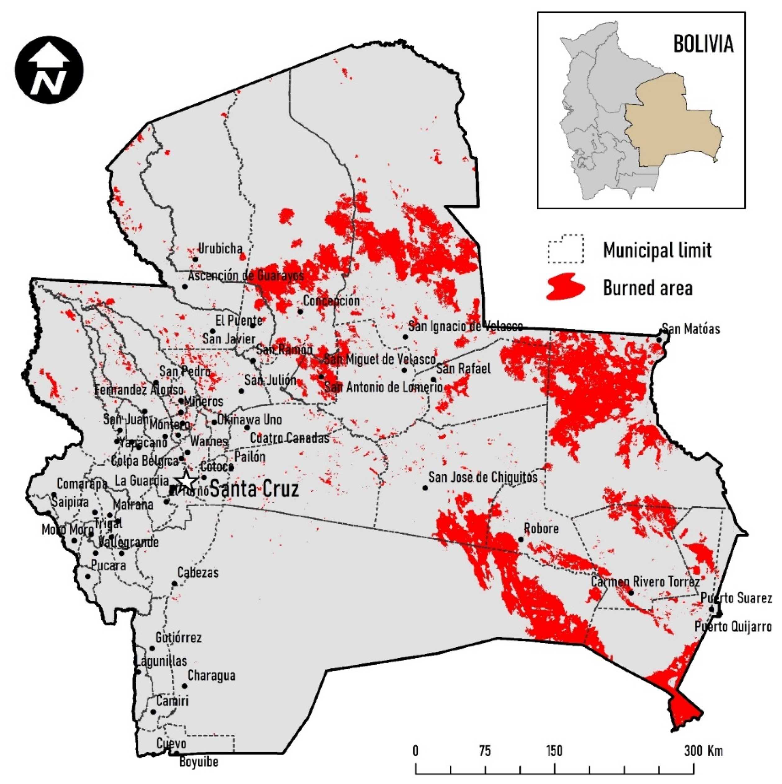
2.1. Study Area

The study area includes the Department of Santa Cruz where the largest forest fires occurred in Bolivia during 2019, and includes an administrative region composed of 56 municipalities (Figure 1). This Department has an area of 369,006 km² and is located between latitude 13°40′–20°20′ S and longitude 57°30′–64°40′ W, bordering the Department of Beni to the north, the Department of Cochabamba to the west, the Department of Chuquisaca and the Paraguay to the south and Brazil to the east. The region is characterized by low elevation and few mountain ranges scattered in the central and eastern sector, which do not exceed 1250 m. To the west, in the Andean region, the elevations reach almost 3100 m.
In the Department of Santa Cruz, there are several forest formations, such as the Amazon, Bolivian-Tucuman, Chaqueño, Chiquitano (and its transition areas Amazon and Chaqueño) and the Yungueño [27]. The Chiquitano forest, the best-conserved dry forest in the continent (Figure 2) and one of the most endangered ecosystems globally [28], was the most impacted by forest fires in 2019 [24].

2.2. Sources of Information and Methods

Fire and vegetation maps used in this study were generated from satellite images from the Landsat 8 OLIsensor, with a spatial resolution of 30 m, and processed on the Google Earth Engine cloud computing platform (GEE) [29]. Atmospherically corrected images were used (Tier 1 surface reflectance), with cloud coverage below 20%. The cloud cover was masked by a filter using the quality assessment (QA) band. In the case of burn scar detection, scenes were downloaded from the EarthExplorer portal (https://earthexplorer.usgs.gov/).
To characterize meteorological drought severity, total monthly precipitation (mm) as well as minimum and maximum temperature (°C) data from eight meteorological stations in the Department of Santa Cruz (Ascensión de Guarayos, Camiri, Puerto Suárez, Roboré, San Ignacio de Velasco, San Javier, San José de Chiquitos, Vallegrande) were available. The data was provided by the National Meteorological and Hydrological Service (SENHAMI, http://senamhi.gob.bo) for the period 1980–2019. A quality control and homogeneity of the series was based on Climatol 3.1.1 (http://www.climatol.eu) [30].

2.2.1. Obtaining the Vegetation Cover

To characterize vegetation types, we performed a supervised classification of 122 Landsat 8 images (July to November 2018) using the random forest (RF) algorithm [31]. This is a non-parametric automatic learning method based on decision tree classification [31], executed on the code editor of the GEE platform. Since most of the forests present phenological changes in the period between the end of the dry season and the beginning of the wet season, mainly in Chaco and Chiquitano forests, we calculated the median value for each band, after cloud masking for the satellite images using the GEE platform. We trained the RF classifier with the dispersion of training sites for the forest, non-forest (grasslands, shrublands and rocky outcrops), anthropogenic (urban, road, crops and areas converted for livestock grazing) and water body (rivers and lagoons) categories. Confusion between certain anthropogenic and non-forest areas in the classification obtained with the RF algorithm was rectified by reclassifying with ArcMap 10.6 (Figure 3). To evaluate the level of uncertainty of the resulting classification, 940 field verification points were obtained between 2017 and 2020. Of these points, 295 were obtained with GPS, 369 sites were taken with the KoBo Collect mobile application (https://www.kobotoolbox.org/) and another 276 with ultra-high resolution images acquired with DJI Mavic Pro model UAVs. Additionally, 60 centroids were obtained for lagoons larger than 4 km2. The total of 1000 verification points were grouped in four categories (forest, non-forest, human and water) and combined with the land cover classification for the year 2019. This approach allowed obtaining a confusion matrix [32] and three types of accuracy estimates: overall accuracy, user’s accuracy and producer’s accuracy, including their 95% confidence intervals [32]. The confidence level obtained from the coverage classification was 85% (Table 1).

2.2.2. Forest Fragmentation

Fragmentation is defined as the breaking up of a habitat or type of natural cover into smaller, disconnected areas [33]. We analyze fragmentation by assessing the relative distribution of forest patches according to their size. To determine forest fragmentation, we used the Accounting tool from the GuidosToolbox 2.8 program (https://forest.jrc.ec.europa.eu/en/activities/lpa/gtb) [34], which has shown good results at the global scale [35]. In GuidosToolbox, the pixel resolution (here 30 m) of the forest cover map is combined with the user-selected thresholds to automatically derive respective area size classes in hectares. Seven size class ranges of the forest extend were defined for this study: <20 ha, 20–200 ha, 200–2000 ha, 2000–20,000 ha, 20,000–200,000 ha, 200,000–2,000,000 ha and >2,000,000 ha (Figure 4A).

2.2.3. Distance from Anthropogenic and Forest Areas

We quantified the forest areas according to the proximity to the anthropogenic areas (roads, agriculture, livestock and urban centers) resulting from the classification of the cover and the distance to the forest edge (Figure 4B,C). This analysis was provided through the tool Euclidean distance of the program GuidosToolbox.

2.2.4. Meteorological Drought

The severity of the meteorological drought was characterized by the standardized precipitation-evapotranspiration index (SPEI) [36]. The SPEI is calculated as a function of the difference between precipitation and atmospheric evaporative demand (AED), which was estimated using the method of Hargreaves and Samani (1985) [37], using maximum and minimum air temperature data. The SPEI allows a spatial and temporal comparison of drought severity conditions regardless of the different seasonality and magnitude of average climatic conditions. For this study we used a 12-month time scale, which summarizes the drought conditions on an annual basis.
We also analyzed trends of droughts indices in the region for the period 1980–2019. The non-parametric Mann-Kendall test (Z) was used for this purpose. To determine the magnitude of the trend in the time series we used the Sen (Q) slope estimator. SPEI values for the year 2019 were interpolated using the inverse distance weighted (IDW) method, with a spatial resolution of 30 m, in order to identify possible spatial differences in the drought severity. Subsequently the mean SPEI was calculated between July and October 2019, the months in which the highest concentration of forest fires was recorded (Figure 4D).

2.2.5. Identification of Burn Scars

We carried out an identification of burned areas for the year 2019 (Figure 1) using 54 Landsat 8 OLI scenes. We identified the burned areas in the scenes of the months of the July–December period through an unsupervised classification with the ISODATA (interactive self-organizing data analysis algorithm) [38]. The classification was carried out with 100 iterations and a convergence threshold equal to 1. This resulted in a thematic classification of 25 spectral classes. A combination of image-specific RGB bands was also used for a visual review of the burned area detection and classification procedure. Additionally, the NBR (normalized burn ratio) and dNBR (normalized delta burn ratio) indices proposed by Key and Benson (2006) [39], in the GEE platform, were obtained from the Landsat images. To determine the NBR, the near infrared (NIR) and short-wave infrared (SWIR) bands of the scenes were used for the pre-flame (2018) and post-flame (2019) periods. The dNBR was determined from the results of the pre- and post-burn periods. The results of both analyses (ISODATA and dNBR) were vectorized in ArcMap. The validation of the burn scars was performed with 192 field points, which were randomly distributed. In total, 39 sampling plots were obtained through the composite burn index [39], 11 sampling points with KoboCollect application and 142 points with high resolution images taken with UAV. The confidence level obtained was 97%.

2.2.6. Statistical Analysis

We analyzed the incidence (%) of burned area in each forest patch size class with respect to the proximity to anthropogenic areas (roads, agriculture, livestock and urban centers). The analysis is conducted on, and with identical spatial resolution of the forest mask data by applying the Euclidean distance function to anthropogenic data areas. The result shows the shortest distance, or proximity, between any forest edge and the nearest anthropogenic data area. To determine the relationship between the occurrence of forest fires and the distance from the anthropogenic areas as well as the distance from the forest edge, the severity of the drought and the relative correlation with burned forest patches, 100,000 random points were distributed for each of the size categories of the forest area. Subsequently, the Lilliefors normality test [40] was performed using the R Nortest package [41]. Since none of the variables fit a normal distribution (p < 0.05), the Spearman (Rho) non-parametric correlation test was applied to analyze the relationship between them.

3. Results

3.1. Forest Fragmentation

With a total forest coverage of 70.7% in 2019, the Department of Santa Cruz is of high significance in terms of forest areas in the region. We have found that non-fragmented (homogenous) stands represented the majority of the forest area studied. Homogeneous forests of more than >2,000,000 ha represent the largest proportion with 57.9%, followed by the class between 200,000 and 2,000,000 ha with 22.5% (Table 2). On the contrary, the most fragmented forest areas only represent a small percentage of the total area.

3.2. Burn Scars

The burned areas in the Department of Santa Cruz in 2019 comprised of 3,717,450 ha, of which 60.1% were affected forest areas, 31.8% were impacted natural, non-forest vegetation (Cerrado, Abayoy) and 7.9% were impacted areas of anthropogenic use. There were 8094 independently burned areas with an average area of 459 ha (range 0–822,474 ha, ±SD 13,856), mainly affecting to the east of the region.

3.3. Evolution of Meteorological Droughts

In general, the analyzed data from the different weather stations showed that recorded in 2019 was characterized by strong severity (Figure 5). In the period between 1980 and 2019, there is a negative trend suggesting an increase in the frequency (Z = −2.50, p < 0.05) and intensity (Q = −0.022, p < 0.05) of droughts throughout the Department of Santa Cruz. During this period all meteorological stations, which obtained significant values (p < 0.05), present negative tendencies in the SPEI (Table 3), mainly in Ascención de Guarayos (Z = −3.20, Q = −0.04), Puerto Suárez, (Z = −3.16, Q = −0.04), San Ignacio de Velasco (Z = −2.46, Q = −0.03) and San José de Chiquitos (Z = −2.09, Q = −0.03).

3.4. Relationship between Forest Patch Characteristics and Fire Incidence

The fires mainly impacted large homogeneous forest areas, i.e., 61.9% of the burned area in 2019 was recorded in patches >2,000,000 ha (Table 4). However, when looking at the relative proportions, the areas characterized by a high fragmentation were the most impacted by fires. Although small forest patches represent a low percentage in relation to the total forest area, they were highly impacted by fires in patches of less than 20 ha of forest, 17.1% were burned, and in those between 20 and 200 ha, 10.1% were burned (Table 4). In terms of the number of patches, forest areas <20 ha were the most impacted. About 118,058 forest patches (3.8% of the burned forests) presented some degree of impact by these fires (Table 4).

3.5. Influence of Distance to Forest Edges and Human Settlements

Forest fires impacted the forest cover at a maximum distance of 40.3 km from anthropogenic areas. Within a range of 5 km, fires mainly impacted the first 500 m of distance from anthropogenic areas, which corresponded to the 25.2% of the total burned area. This aspect is emphasized by the analysis of the first kilometer, considering intervals of every 100 m, where 10–12% of the burned areas were detected up to the first 500 m (Figure 6).
From the forest edge, fires impacted up to a maximum distance of 5.4 km. In a range of 5 km from the forest edge, 71.1% occurred in the first 500 m (Figure 6). In the range of the first kilometer from the forest edge, 33.9% of the burned area was in the range of 0–100 m, 20.1% in the range 100–200 m and the rest of the area correspond to smaller percentages (Figure 6).

3.6. Relationship of Distance to Forest Edges and to Anthropogenic Zones and Impact of Drought Severity

In most of the size classes of forest patches impacted by forest fires, the distance relationships (forest edge and anthropogenic), the percentage of burns and the drought index (SPEI-12) were statistically significant (Table A1). For forest patches of 2000–20,000 ha, a relationship between distance to anthropic areas and percentage of forest burned was recorded (Rho = 0.52). Regarding the forest patches of 20,000–200,000, a relation between the SPEI-12 and the percentage of the forest burned (Rho = −0.51) was also evident. Furthermore, in the forest patch class of the range 200,000–2,000,000 ha, there was a relationship between the anthropogenic distance and the percentage of forest burned (Rho = 0.52).

4. Discussion

This study analyzed patterns of fire in 2019 with respect to forest fragmentation and spatial variation of drought severity in the Department of Santa Cruz. The forests fires of 2019 were one of the most devastating since the beginning of records [22,24,42,43,44]. Given the total forest size structure, the forest fires mostly impacted the three largest forest patches (>2,000,000 ha). Nevertheless, proportionally the fragmented forests (<20 ha) were the most affected by forests fires. Some studies have shown that selective logging increases accessibility as well as fire risk within intact forests [45,46]. Consequently, there is an urgent need for better land use planning and management through public policies in order to maintain the largest forest fragments intact [47]. Furthermore, forest fragmentation has a strong impact on the overall connectivity across the landscape and therefore presents an increased survival risk and a decrease of habitat quality for many species, especially those that are most vulnerable to changes (e.g., Jaguar) [22].
Nevertheless, and for many years, prescribed burning has been a common and cheap practice to clear crop areas or renew pastures in Bolivia [44,48,49]. In some natural areas, fire is necessary to maintain ecological conditions, as in the case of the Cerrado [50,51]. However, we found that 60% of the areas burned in 2019 were part of forest formations and this may have negative consequences, especially for forest formations [44]. Historically, in some regions such as the Chiquitano forest there is a very strong pattern of recurrent fire in anthropogenic areas [52], being one of the main causes of the forest degradation [17]. In addition, degraded forests increase the risk of forest fire spread.
Four conditions have been characterized as switches for forest fires to occur [53,54]: the presence of fuel (biomass), the dry or humid conditions of the biomass available to burn, weather conditions (low humidity combined with high temperatures and high wind speeds) and an ignition source. However, in the Amazon region [8,10], it is known that the probability of the occurrence of forest fires can change with the distance to the edge of the forest fragment in relation to the core of that fragment. Within a few days of logging operations, drastic changes in humidity and temperature levels are evident in relation to the interior of the forest [55]. Low fuel moisture content increases the probability of ignition, the rate of fire spread and the fire intensity [56]. Intact forests show microclimates with less penetration of wind and solar radiation. Forest edges show high tree mortality, while fragmented forests are more susceptible to the occurrence of fires due to the edge effect [7,13,57,58,59,60]. This would explain that in the Santa Cruz region we have found that distances of less than 500 m to the forest edge (range of 5 km) show a higher percentage impacted by forest fires (71%). A study conducted by Bounoua et al. (2004) [61] in the Santa Cruz lowlands suggested that the conversion of forests into farmland involves morphological changes in the vegetation, which generates a decrease in the conductance of the canopy and consequently an increase in the local temperature of approximately 2 °C, which could additionally increase the risk of the forest fire expansion.
We should note with an increase of the fire risk in dry forests, such as Chaco and Chiquitano forest, the risk of fire increases given the climate trends, but also because of the introduction of non-native grasses and shrubs into the livestock and agricultural production matrices that surround dry forests [62]. Their presence increases the combustible biomass [63] and might change forest fire regimes [64,65,66]. Probably most of these changes would mostly affect the edges of the forest, which would explain the higher frequency of burned areas found in the Santa Cruz region.
Small, isolated forest fragments are more likely to disappear compared to larger fragments [59,67]. In the Department of Santa Cruz, small forest fragments (<20 ha and 20–200 ha) were severely impacted by fires in 2019 (27.2%) and many of these are fragments resulting from the advance of the agricultural frontier. Among these fragments, there are those that are left as strips of ecological easements (forests near rivers, streams or lakes) or windbreaks. These windbreaks are strips of trees with natural or planted vegetation between clearings. Directed in a perpendicular direction to the dominant wind and separated by planks (the distance between one windbreak and another). In the property management plans (POP), instruments that zone the lands of a property according to their different capacities of use, both curtains and planks are planned. In the POPs, the current legal administrative resolutions of Bolivia (R.A. ABT 185/2017) stipulate that these curtains should have a minimum width of 30 m (exception for the case of reforestation with >10 m), while the width of the plank is based on the height of the dominant trees and should not be greater than ten times the height of those trees. The relationship between forest fragmentation and the probability of burning found in this study for the year 2019 demonstrates that the current regulations, regarding the configuration of forest fragments (windbreaks, strips of ecological easements and forest blocks in agricultural areas) should be reviewed. An amended regulation may provide improved preventive measures, appropriately addressing forest vulnerability to fire resulting from deforestation of forest fragmentation events. Previous studies show that in the Chiquitano Dry Forest, the reduction of small forest patches generates changes in the composition, structure and floral diversity [68] demanding for a revision of related public policies.
Considering the new scenario posed by the evolution of the Great Forest Fires that have occurred in the year 2019 in Santa Cruz [69], there is an increasingly urgent need for adaptation strategies to climate change since droughts are expected to be more frequent and severe [70]. In 2019, we found a relation between drought severity and the spatial patterns of forests fires, suggesting that drier conditions favor the propagation of forest fires. Due to the accumulation of dry materials, droughts increase the fire risk, in particular in the years of an El Niño event [71]. In 2010, one of the most extreme droughts was recorded in the Amazon [72,73,74], which also expanded to the Chiquitano Dry Forest [44,75]. At the same time an alarming concentration of fires was reported [42,76], representing the largest area known to be impacted by fires before 2019.
Consequently, these facts should give rise to agricultural production models that promote integrated practices [77], prioritizing the maintenance of forest blocks with a larger scale than that currently used. This might imply the revision and rethinking of current regulations to better address and adapt to future climate change projections and predicting increasing forest degradation, which may increment areas burned by forest fires [4,78]. For certain areas of the Brazilian Amazon, they are projected to double by 2050, affecting up to 16% of the forests [79]. Meanwhile, for the Chiquitania region in Bolivia, the interactions between extreme drought conditions and the rapid expansion of the agricultural frontier make the probability of increased fire risk by 2025 up to 1.8 times higher, compared to the 2010 fire event [76].
In Bolivia, the ecology of forest fires is a subject that we are trying to understand and there is still much to investigate. We believe that future studies should be aimed at learning more about the dynamics of forest fires, considering the predominance of the direction and intensity of the winds, as well as the combustibility, flammability, calorific value and age of the vegetation, as this will influence the intensity and speed of propagation and, indirectly, the size of the fires.

5. Conclusions

The present state of the forests in the Department of Santa Cruz is worrisome since there is evidence that the fragmentation of the forests in combination with the droughts, in abundance of anthropogenic ignition sources, causes the fire to progressively expand towards the interior of the forest. The edge effect generated in the matrix of forests and anthropogenic areas enhances the expansion of fire towards the interior of forests, independently of their size. However, in the smaller fragments (<20 ha) the level of impact in relation to the surface is higher, increasing the probability of these fragments to disappear much faster. Furthermore, small fragments are important as shelter and habitat for wildlife and serve as connectivity corridors.
Considering the trends of climate change in Eastern Bolivia and especially in ecosystems with a seasonal water deficit and the greater penetration of anthropogenic activities (agricultural expansion and livestock) in continuous forest areas, it is necessary to redefine rules and public policies aimed at land management at multiple scales that take into account these risk factors. Undoubtedly, the revision of the design criteria of the land management plans, the fulfillment of the economic and social function of private and communal properties and the promotion of the protection and restoration of ecological easements will improve the opportunities for the reduction of forest fires and the maintenance of ecological functionality at the landscape scale in the Department of Santa Cruz.

Author Contributions

Conceptualization, O.M. and R.V.-A.; Methodology, O.M., M.F.-V., R.C., P.V. and S.M.V.-S.; Validation, O.M.; Formal Analysis, O.M., M.F.-V. and R.C.; Investigation, O.M., R.V.-A. and H.A.; Writing—Original Draft Preparation, O.M.; Writing—Review and Editing, R.V.-A., S.M.V.-S., H.A. and P.V.; Supervision, R.A. and R.L.C.; Funding Acquisition, R.V.-A. All authors have read and agreed to the published version of the manuscript.

Funding

This study has been developed as part of a series of investigations by the FCBC Chiquitano Forest Observatory in the framework of the ECCOS project, financed by the European Union.

Acknowledgments

We thank the National Service of Meteorology and Hydrology (SENAMHI), for all the help provided to access the data from the weather stations. We are grateful to Nicolas Mielich, Carla Pinto, Sixto Angulo, William Alfaro, Tito Arana, Daniel Coimbra, Reinaldo Flores, Rossy Montaño, Weimar Torres, Edgar Viveros and Karla Villegas (SERNAP), for their valuable help. We thank the editor and two anonymous reviewers for their insightful comments and suggestions that greatly helped improve our manuscript.

Conflicts of Interest

The authors declare no conflict of interest.

Appendix A

Table A1. Spearman (Rho) correlation between forest patch size classes, distance (forest edge and anthropogenic), forest burn (%) and drought variables (SPEI-12).
Size Classes Forest Patches (ha)VariablesDistance to ForestDistance AnthropogenicSPEI-12% Forest Burn
<20Distance forest1.00
Anthropogenic distance0.041.00
SPEI-12−0.10−0.231.00
% Forest burnnsnsns1.00
20–200Distance forest1.00
Anthropogenic distance0.081.00
SPEI-12−0.10−0.231.00
% Forest burnnsnsns1.00
200–2000Distance forest1.00
Anthropogenic distance0.191.00
SPEI-12−0.08−0.121.00
% Forest burn0.260.44−0.081.00
2000–20,000Distance forest1.00
Anthropogenic distance0.291.00
SPEI-12ns0.291.00
% Forest burn0.190.520.331.00
20,000–200,000Distance forest1.00
Anthropogenic distance0.421.00
SPEI-12−0.43−0.611.00
% Forest burn0.280.44−0.511.00
200,000–2,000,000Distance forest1.00
Anthropogenic distance0.451.00
SPEI-12−0.240.551.00
% Forest burn0.490.52−0.241.00
>2,000,000Distance forest1.00
Anthropogenic distance0.111.00
SPEI-120.23−0.181.00
% Forest burn0.04−0.120.491.00

References

  1. Wilson, M.C.; Xiao-Yong, C.; Corlett, R.T.; Didham, R.K.; Ping, D.; Holt, R.D.; Holyoak, M.; Guang, H.; Hughes, A.C.; Lin, J.; et al. Habitat fragmentation and biodiversity conservation: Key findings and future challenges. Landsc. Ecol. 2016, 31, 219–227. [Google Scholar] [CrossRef] [Green Version]
  2. Gatti, L.; Gloor, M.; Miller, J.; Doughty, C.; Malhi, Y.; Domingues, L.; Basso, L.; Martinewski, A.; Correia, C.; Borges, V. Drought sensitivity of Amazonian carbon balance revealed by atmospheric measurements. Nature 2014, 506, 76–80. [Google Scholar] [CrossRef] [PubMed]
  3. Lizundia-Loiola, J.; Pettinari, M.L.; Chuvieco, E. Temporal Anomalies in Burned Area Trends: Satellite Estimations of the Amazonian 2019 Fire Crisis. Remote Sens. 2020, 12, 151. [Google Scholar] [CrossRef] [Green Version]
  4. De Faria, B.L.; Brando, P.M.; Macedo, M.N.; Panday, P.K.; Soares-Filho, B.S.; Coe, M.T. Current and future patterns of fire-induced forest degradation in Amazonia. Environ. Res. Lett. 2017, 12, 095005. [Google Scholar] [CrossRef]
  5. Aragão, L.E.O.C.; Anderson, L.O.; Fonseca, M.G.; Rosan, T.M.; Vedovato, L.B.; Wagner, F.H.; Silva, C.V.J.; Silva Junior, C.H.L.; Arai, E.; Aguiar, A.P.; et al. 21st Century drought-related fires counteract the decline of Amazon deforestation carbon emissions. Nat. Commun. 2018, 9, 536. [Google Scholar] [CrossRef]
  6. Cunha, A.P.M.A.; Zeri, M.; Deusdará Leal, K.; Costa, L.; Cuartas, L.A.; Marengo, J.A.; Tomasella, J.; Vieira, R.M.; Barbosa, A.A.; Cunningham, C.; et al. Extreme Drought Events over Brazil from 2011 to 2019. Atmosphere 2019, 10, 642. [Google Scholar] [CrossRef] [Green Version]
  7. Laurance, W.F.; Vasconcelos, H.L.; Lovejoy, T.E. Forest loss and fragmentation in the Amazon: Implications for wildlife conservation. Oryx 2000, 34, 39–45. [Google Scholar] [CrossRef]
  8. Cochrane, M.A. Synergistic interactions between habitat fragmentation and fire in evergreen tropical forests. Conserv. Biol. 2001, 15, 1515–1521. [Google Scholar] [CrossRef]
  9. Laurance, W.F.; Williamson, G.B. Positive Feedbacks among Forest Fragmentation, Drought, and Climate Change in the Amazon. Conserv. Biol. 2001, 15, 1529–1535. [Google Scholar] [CrossRef] [Green Version]
  10. Cochrane, M.A.; Laurance, W.F. Fire as a large-scale edge effect in Amazonian forests. J. Trop. Ecol. 2002, 18, 311–325. [Google Scholar] [CrossRef] [Green Version]
  11. Cochrane, M.A. Fire science for rainforests. Nature 2003, 421, 913–919. [Google Scholar] [CrossRef] [PubMed]
  12. Numata, I.; Silva, S.; Cochrane, M.A.; d’Oliveira, M.V.N. Fire and edge effects in a fragmented tropical forest landscape in the southwestern Amazon. For. Ecol. Manag. 2017, 401, 135–146. [Google Scholar] [CrossRef] [Green Version]
  13. Silva Junior, C.H.L.; Aragão, L.E.O.C.; Fonseca, M.G.; Almeida, C.T.; Vedovato, L.B.; Anderson, L.O. Deforestation-Induced Fragmentation Increases Forest Fire Occurrence in Central Brazilian Amazonia. Forests 2018, 9, 305. [Google Scholar] [CrossRef] [Green Version]
  14. Cano-Crespo, A.; Oliveira, P.J.C.; Boit, A.; Cardoso, M.; Thonicke, K. Forest edge burning in the Brazilian Amazon promoted by escaping fires from managed pastures. J. Geophys. Res. Biogeosci. 2015, 120, 2095–2107. [Google Scholar] [CrossRef] [Green Version]
  15. Killeen, T.J.; Guerra, A.; Calzada, R.; Correa, L.; Calderon, V.; Soria, L.; Quezada, B.; Steininger, M. Total historical land-use change in eastern Bolivia: Who, where, when, and how much? Ecol. Soc. 2008, 19, 36. [Google Scholar] [CrossRef] [Green Version]
  16. Hansen, M.C.; Potapov, P.V.; Moore, R.; Hancher, M.; Turubanova, S.A.; Tyukavina, A.; Thau, D.; Stehman, S.V.; Goetz, S.J.; Loveland, T.R.; et al. High-resolution global maps of 21st–century forest cover change. Science 342:850–853. Int. J. Adv. Eng. Technol. 2013, 7, 1161–1169. [Google Scholar]
  17. Müller, R.; Pacheco, P.; Montero, J.C. El Contexto de la Deforestación y Degradación de los Bosques en Bolivia: Causas, Actores e Instituciones; CIFOR: Bagor, Rajasthan, India, 2014; 89p. [Google Scholar]
  18. Steininger, M.K.; Tucker, C.J.; Ersts, P.; Killeen, T.J.; Villegas, Z.; Hecht, S.B. Clearance and Fragmentation of Tropical Deciduous Forest in the Tierras Bajas, Santa Cruz, Bolivia. Conserv. Biol. 2001, 15, 856–866. [Google Scholar] [CrossRef]
  19. Pinto, J.N.L.; Ruíz, T.C. Patrones de deforestación y fragmentación 1976-2006 en el municipio San Julián (Santa Cruz, Bolivia). Ecol. Boliv. 2010, 45, 101–115. [Google Scholar]
  20. Arancibia-Arce, L.R.; Perotto-Baldivieso, H.L.; Furlán, J.R.; Castillo-García, M.; Soria, L.; Rivero-Guzmán, K. Evaluación espacial y temporal de fragmentación y conectividad para actividades ecoturísticas en un sitio RAMSAR: Los Bañados de Isoso (Santa Cruz, Bolivia). Ecol. Boliv. 2013, 48, 87–103. [Google Scholar]
  21. Pinto-Ledezma, J.N.; Rivero, M.K. Temporal patterns of deforestation and fragmentation in lowland Bolivia: Implications for climate change. Clim. Chang. 2014, 127, 43–54. [Google Scholar] [CrossRef]
  22. Maillard, O.; Angulo, S.; Vides-Almonacid, R.; Rumiz, D.; Vogt, P.; Monroy-Vilchis, O.; Justiniano, H.; Azurduy, H.; Coronado, R.; Venegas, C.; et al. Integridad del paisaje y riesgos de degradación del hábitat del jaguar (Panthera onca) en áreas ganaderas de las tierras bajas de Santa Cruz, Bolivia. Ecol. Boliv. 2020, 55, 128–149. [Google Scholar]
  23. Romero-Muñoz, A.; Jansen, M.; Nuñez, A.M.; Toledo, M.; Almonacid, R.V.; Kuemmerle, T. Fires scorching Bolivia’s Chiquitano forest. Science 2019, 366, 1–1082. [Google Scholar] [CrossRef] [PubMed]
  24. Anívarro, R.; Azurduy, H.; Maillard, O.; Markos, A. Diagnóstico por Teledetección de Áreas Quemadas en la Chiquitania; Informe Técnico Del Observatorio Bosque Seco Chiquitano; Fundación para la Conservación del Bosque: Chiquitano, Santa Cruz, 2019; p. 70. [Google Scholar]
  25. Maillard, O.; Azurduy, H.; Bachfischer, M.; Castellnou, M.; Coronado, R.; Angulo, S.; Flores, R. Aportes a la Evaluación de Severidad de Quemas en la Chiquitania. Incendios 2019: Integrando tres Estudios de caso Alta Vista, Laguna Marfil y Ñembi Guasu; Fundación para la Conservación del Bosque: Chiquitano, Santa Cruz, 2020; p. 50. [Google Scholar]
  26. Sánchez-Azofeifa, G.A.; Portillo-Quintero, C. Extent and Drivers of Change of Neotropical Seasonally Dry Tropical Forests. In Seasonally Dry Tropical Forests; Dirzo, R., Young, H.S., Mooney, H.A., Ceballos, G., Eds.; Island Press: Washington, DC, USA, 2011. [Google Scholar]
  27. Fundación Amigos de la Naturaleza. Atlas Socioambiental de las Tierras Bajas y Yungas de Bolivia; Editorial FAN: Santa Cruz de la Sierra, Bolivia, 2015. [Google Scholar]
  28. Ferrer-Paris, J.R.; Zager, I.; Keith, D.A.; Oliveira-Miranda, M.A.; Rodriguez, J.P.; Josse, C.; González-Gil, M.; Miller, R.M.; Zambrana-Torrelio, C.; Barrow, E. An ecosystem risk assessment of temperate and tropical forests of the Americas with an outlook on future conservation strategies. Conserv. Lett. 2019, 12, e12623. [Google Scholar] [CrossRef]
  29. Gorelick, N.; Hancher, M.; Dixon, M.; Ilyushchenko, S.; Thau, D.; Moore, R. Google Earth Engine: Planetary-scale geospatial analysis for everyone. Remote Sens. Environ. 2017, 202, 18–27. [Google Scholar] [CrossRef]
  30. Guijarro, J.A. Daily series homogenization and gridding with Climatol v.3. In Climate Data and Monitoring WCDMP-No.85, Proceedings of the Ninth Seminar for Homogenization and Quality Control in Climatological Databases and Fourth Conf. on Spatial Interpolation Techniques in Climatology and Meteorology, Budapest, Hungary, 3–7 April 2017; WMO: Budapest, Hungary, 2017; pp. 175–180. [Google Scholar]
  31. Breiman, L. Random forests. Mach. Learn. 2001, 45, 5–32. [Google Scholar] [CrossRef] [Green Version]
  32. Olofsson, P.; Foody, G.; Herold, M.; Stehman, S.; Woodcock, C.; Wuldere, M. Good practices for estimating area and assessing accuracy of land change. Remote Sens. Environ. 2014, 148, 42–57. [Google Scholar] [CrossRef]
  33. Turner, M.G.; Gardner, R.H. Landscape Ecology in Theory and Practice. Pattern and Process, 2nd ed.; Springer: Verlag, NY, USA, 2015. [Google Scholar]
  34. Vogt, P.; Riitters, K. GuidosToolbox: Universal digital image object analysis. Eur. J. Remote Sens. 2017, 50, 352–361. [Google Scholar] [CrossRef]
  35. Vogt, P.; Riitters, K.H.; Caudullo, G.; Eckhardt, B. FAO–State of the World’s Forests; Forest Fragmentation: Luxembourg, 2019. [Google Scholar] [CrossRef]
  36. Vicente-Serrano, S.M.; Beguería, S.; López-Moreno, J.I. A multi-scalar drought index sensitive to global warming: The standardized precipitation evapotranspiration index. J. Clim. 2010, 23, 1696–1718. [Google Scholar] [CrossRef] [Green Version]
  37. Hargreaves, G.L.; Samani, Z.A. Reference crop evapotranspiration from temperature. Appl. Eng. Agric. 1985, 1, 96–99. [Google Scholar] [CrossRef]
  38. Ball, G.H.; Hall, D.J. ISODATA, a Novel Method of Data Analysis and Pattern Classification; Stanford Research Institute: Menlo Park, CA, USA, 1965. [Google Scholar]
  39. Key, C.H.; Benson, N.C. Landscape assessment: Ground measure of severity, the composite burn index; and remote sensing of severity, the normalized burn ratio. In Fire Effects Monitoring and Inventory System; Lutes, D.C., Keane, R.E., Caratti, J.F., Key, C.H., Benson, N.C., Sutherland, S., Gangi, L.J., Eds.; USDA Forest Service, Rocky Mountain Research Station: Ogden, UT, USA, 2006; pp. 219–273. [Google Scholar]
  40. Lilliefors, H. On the Kolmogorov-Smirnov test for normality with mean and variance unknown. J. Am. Stat. Assoc. 1967, 62, 399–402. [Google Scholar] [CrossRef]
  41. Gross, J.; Ligges, U. Nortest: Tests for Normality. Available online: https://CRAN.R-project.org/package=nortest (accessed on 23 May 2020).
  42. Rodríguez, A. Cartografía multitemporal de quemas e incendios forestales en Bolivia: Detección y validación post-incendio. Ecol. Boliv. 2012, 47, 53–71. [Google Scholar]
  43. Rodriguez-Montellano, A.M. Incendios y Quemas en Bolivia, Análisis Histórico Desde 2000 a 2013; Editorial FAN: Santa Cruz de la Sierra, Bolivia, 2014. [Google Scholar]
  44. Maillard, O.; Anívarro, R.; Vides-Almonacid, R.; Torres, W. Estado de conservación de los ecosistemas de las serranías chiquitanas: Un caso de estudio de la Lista Roja de Ecosistemas de la UICN en Bolivia. Ecol. Boliv. 2018, 53, 128–149. [Google Scholar]
  45. Asner, G.P.; Knapp, D.E.; Broadbent, E.N.; Oliveira, P.J.; Keller, M.; Silva, J.N. Selective logging in the brazilian amazon. Science 2005, 310, 480–482. [Google Scholar] [CrossRef] [PubMed]
  46. Broadbent, E.N.; Asner, G.P.; Keller, M.; Knapp, D.E.; Oliveira, P.J.; Silva, J.N. Forest fragmentation and edge effects from deforestation and selective logging in the brazilian amazon. Biol. Conserv. 2008, 141, 1745–1757. [Google Scholar] [CrossRef]
  47. Hansen, M.C.; Wang, L.; Song, X.P.; Tyukavina, A.; Turubanova, S.; Potapov, P.V.; Stehman, S.V. The fate of tropical forest fragments. Sci. Adv. 2020, 6, eaax8574. [Google Scholar] [CrossRef] [Green Version]
  48. McDaniel, J.; Kennard, D.; Fuentes, A. Smokey the tapir: Traditional fire knowledge and fire prevention campaigns in lowland Bolivia. Soc. Nat. Resour. 2005, 18, 921–931. [Google Scholar] [CrossRef]
  49. TIERRA. Fuego en Santa Cruz. Balance de los Incendios Forestales 2019 y su Relación con la Tenencia de la Tierra; Edición TIERRA: Santa Cruz, Bolivia, 2019. [Google Scholar]
  50. Pivello, V.R. Fire Management for Biological Conservation in the Brazilian Cerrado; Savana and Dry Forests. Linking People with Nature; Mistry, J., Berardi, A., Eds.; Ashgate: Farnham, UK, 2006; pp. 129–154. [Google Scholar]
  51. Wood, J.R.I.; Mamani, F.; Pozo, P.; Soto, D.; Villarroel, D. Libro Rojo de las Plantas de los Cerrados del Oriente Boliviano; Darwin Iniative & Museo de Historia Natural: Noel Kempff Mercado, Santa Cruz, 2010.
  52. Vides-Almonacid, R.; Reichle, S.; Padilla, F. Planificación Ecorregional del Bosque Seco Chiquitano; Editorial Fundación para la Conservación del Bosque: Chiquitano, Santa Cruz, 2007; p. 245. [Google Scholar]
  53. Catchpole, W. Fire Properties and Burn Patterns in Heterogeneous Landscapes. Flammable Australia: The Fire Regimes and Biodiversity of a Continent; Bradstock, R.A., Williams, J.E., GillCambridge, A.M., Eds.; University Press: Cambridge, UK, 2002; pp. 50–75. [Google Scholar]
  54. Bradstock, R.A. A biogeographic model of fire regimes in Australia: Current and future implications. Glob. Ecol. Biogeogr. 2010, 19, 145–158. [Google Scholar] [CrossRef]
  55. Alvarado, E.; Sandberg, D.V.; de Carvalho, J.A., Jr.; Gielow, R.; Santos, J.C. Landscape fragmentation and fire vulnerability in primary forest adjacent to recent land clearings in the Amazon arc of deforestation. Floresta 2004, 34, 169–174. [Google Scholar] [CrossRef] [Green Version]
  56. Rossa, C.G.; Fernandes, P.M. Live fuel moisture content: The ‘pea under the mattress’ of fire spread rate modeling? Fire 2018, 1, 43. [Google Scholar] [CrossRef] [Green Version]
  57. Nepstad, D.; Verissimo, A.; Alencar, A.; Nobre, C.; Eirivelthon, L.; Lefebvre, P.; Schlesinger, P.; Potter, C.; Moutinho, P.; Mendoza, E.; et al. Large-scale impoverishment of Amazonian forests by logging and fire. Nature 1999, 398, 505–508. [Google Scholar] [CrossRef]
  58. D’Angelo, S.A.; Andrade, A.C.S.; Laurance, S.G.; Laurance, W.F.; Mesquita, R.C.G. Inferred causes of tree mortality in fragmented and intact Amazonian forests. J. Trop. Ecol. 2004, 20, 243–246. [Google Scholar] [CrossRef] [Green Version]
  59. Haddad, N.M.; Brudvig, L.A.; Clobert, J.; Davies, K.F.; Gonzalez, A.; Holt, R.D.; Lovejoy, T.E.; Sexton, J.O.; Austin, M.P.; Collins, C.D.; et al. Habitat fragmentation and its lasting impact on earth’s ecosystems. Sci. Adv. 2015, 1, e1500052. [Google Scholar] [CrossRef] [PubMed] [Green Version]
  60. Cochrane, M.A.; Laurance, W.F. Synergisms among Fire, Land Use, and Climate Change in the Amazon. Ambio 2008, 37, 522–527. [Google Scholar] [CrossRef] [PubMed]
  61. Bounoua, L.R.S.; DeFries, M.L.; Imhoff, M.; Steininger, K. Land use and local climate: A case study near Santa Cruz, Bolivia. Meteorol. Atmos. Phys. 2004, 86, 73–85. [Google Scholar] [CrossRef]
  62. González-M, R.; García, H.; Isaacs, P.; Cuadros, H.; López-Camacho, R.; Rodriguez, N.; Pérez, K.; Mijares, F.; Castano-Naranjo, A.; Jurado, R.; et al. Disentangling the environmental heterogeneity, floristic distinctiveness and current threats of tropical dry forests in Colombia. Environ. Res. Lett. 2018, 13, 45007. [Google Scholar]
  63. Veldman, J.; Putz, F.E. Grass-dominated vegetation, not species-diverse natural savanna, replaces degraded tropical forests on the southern edge of the Amazon Basin. Biol. Conserv. 2011, 144, 1419–1429. [Google Scholar] [CrossRef]
  64. D’Antonio, C.; Vitousek, P. Biological invasions by exotic grasses, the grass/fire cycle, and global change. Annu. Rev. Ecol. Syst. 1992, 23, 63–87. [Google Scholar] [CrossRef]
  65. Nepstad, D.C.; Lefebvre, P.; Lopes da Silva, U.J.; Tomasella, P.; Schlesinger, L.; Solórzano, P.; Moutinho, D.; Ray, J.; Guerreira, B. Amazon drought and its implications for forest flammability and tree growth: A basin-wide analysis. Glob. Chang. Biol. 2004, 10, 704–717. [Google Scholar] [CrossRef]
  66. Silvério, D.V.; Brando, P.M.; Balch, J.K.; Putz, F.E.; Nepstad, D.C.; Oliveira-Santos, C.; Bustamante, M.M.C. Testing the Amazon savannization hypothesis: Fire effects on invasion of a neotropical forest by native cerrado and exotic pasture grasses. Philos. Trans. R. Soc. B 2013, 368, 20120427. [Google Scholar] [CrossRef]
  67. Gascon, C.; Williamson, G.B.; da Fonseca, G.A. Receding forest edges and vanishing reserves. Science 2000, 288, 1356–1358. [Google Scholar] [CrossRef]
  68. Lazarte, M.C. Efecto de Borde en la Composición, Estructura y Diversidad Florística en Fragmentos de Bosque (Cortinas Rompe-Vientos) Semideciduo Chiquitano, “Propiedad Agrícola San Rafael”, Cuatro Cañadas, Santa Cruz–Bolivia. Bachelor’s Thesis, Universidad Autónoma Gabriel René Moreno, Santa Cruz de la Sierra, Bolivia, 2009. [Google Scholar]
  69. Castellnou, M.L.; Alfaro, M.; Miralles, D.; Montoya, B.; Ruiz, T.; Artes, L.; Besold, J.; Brull, F.; Ramirez, M.A.; Botella, F.; et al. Field journal: Bolivia learning to fight a new kind of fire. Analyzing and acting on extreme wildfires in Chaco (Bolivia) and Cerrado (Paraguay) ecosystems. Wildfire Mag. 2019, 28, 26–34. [Google Scholar]
  70. Brando, P.M.; Paolucci, L.; Ummenhofer, C.C.; Ordway, E.M.; Hartmann, H.; Cattau, M.E.; Rattis, L.; Medjibe, V.; Coe, M.T.; Balch, J. Droughts, Wildfires, and Forest Carbon Cycling: A Pantropical Synthesis. Annu. Rev. Earth Planet. Sci. 2019, 47, 555–581. [Google Scholar] [CrossRef]
  71. Chen, Y.; Morton, D.C.; Andela, N.; van der Werf, G.R.; Giglio, L.; Randerson, J.T. A pan-tropical cascade of fire driven by El Niño/Southern Oscillation. Nat. Clim. Chang. 2017, 7, 906–911. [Google Scholar] [CrossRef]
  72. Marengo, J.; Tomasella, J.; Alves, L.; Soares, W.; Rodríguez, D. The drought of 2010 in the context of historical droughts in the Amazon region. Geophys. Res. Lett. 2011, 38, 1–13. [Google Scholar] [CrossRef] [Green Version]
  73. Blunden, J.; Arndt, D. State of the Climate in 2016. Bull. Am. Meteorol. Soc. 2017, 98, S1–S282. [Google Scholar] [CrossRef] [Green Version]
  74. Erfanian, A.; Wang, G.; Fomenko, L. Unprecedented drought over tropical South America in 2016: Significantly under-predicted by tropical SST. Sci. Rep. 2017, 7, 1–11. [Google Scholar] [CrossRef] [Green Version]
  75. Maillard, O.; Salinas, J.C.; Angulo, S.; Vides-Almonacid, R. Riesgos ambientales en las unidades hidrográficas de las serranías chiquitanas, departamento de Santa Cruz, Bolivia. Ecol. Boliv. 2019, 54, 84–97. [Google Scholar]
  76. Devisscher, T.; Anderson, L.O.; Aragão, L.E.O.C.; Galván, L.; Malhi, L. Increased wildfire risk driven by climate and development interactions in Bolivian Chiquitania, southern Amazonia. PLoS ONE 2016, 11, e0161323. [Google Scholar] [CrossRef] [Green Version]
  77. Calle, Z.; Murgueitio, E.; Chará, J. Integrating forestry, sustainable cattle-ranching and landscape restoration. Unasylva 2012, 239, 31–40. [Google Scholar]
  78. Alencar, A.A.; Brando, P.M.; Asner, G.P.; Putz, F.E. Landscape fragmentation, severe drought, and the new Amazon forest fire regime. Ecol. Appl. 2015, 25, 1493–1505. [Google Scholar] [CrossRef]
  79. Brando, P.M.; Soares-Filho, B.; Rodrigues, L.; Assunção, A.; Morton, D.; Tuchschneider, D.; Fernandes, E.C.M.; Macedo, M.N.; Oliveira, U.; Coe, M.T. The gathering firestorm in southern Amazonia. Sci. Adv. 2020, 6, eaay1632. [Google Scholar] [CrossRef] [PubMed] [Green Version]
Figure 1. Location of the Department of Santa Cruz, Bolivia and scars from areas burned in 2019.
Forests 11 00910 g001
Figure 2. Forest fires in the year 2019, spreading for kilometers in the Chiquitano Forest, area of the municipality of Concepción. Photo: Daniel Coimbra.
Forests 11 00910 g002
Figure 3. Anthropogenic land use and vegetation cover of the Department of Santa Cruz.
Forests 11 00910 g003
Figure 4. Variables used in the analysis to determine the relationship between fragmentation and burns in the year 2019, in the Department of Santa Cruz. (A) Categories of forest patch sizes, (B) Euclidean distance to anthropogenic areas, (C) Euclidean distance to forest areas and (D) average of the July to October 12-month standardized precipitation-evapotranspiration index (SPEI).
Forests 11 00910 g004
Figure 5. SPEI-12 time series (1980–2019) in eight weather stations in the Department of Santa Cruz.
Forests 11 00910 g005aForests 11 00910 g005b
Figure 6. Proportion of forest cover impacted by fires, in relation to the distance from the forest edge and anthropogenic areas, in intervals of (A) 500 m for the first five kilometers and (B) 100 m for the first kilometer.
Forests 11 00910 g006
Table 1. Confusion matrix and accuracy statistics.
ClassAnthropogenicForestNon-ForestWaterTotal (Wi a)
Anthropogenic16.24040.34831.132000.1685
Forest2.150660.753621.774500.7070
Non-forest0.25671.24057.40010.04280.1198
Water0000.46620.0047
Total18.647762.342430.30660.50901
User’s accuracy96%86%62%99%
Producer’s accuracy87%97%24%92%
Overall accuracy85%
aWi represents class proportion with respect to the total land area (369,006 km²).
Table 2. Forest patches in the Department of Santa Cruz categorized into seven size ranges.
Size Scales of Forest Patch (ha)Area (ha)Area (%)
<20481,2861.8
20–200514,4872.0
200–20001,092,8554.2
2000–20,0001,639,1716.2
20,000–200,0001,425,4525.4
200,000–2,000,0005,919,07322.5
>2,000,00015,233,94757.9
Table 3. Spatial analyses of drought trends SPEI-12 (1980–2019) for weather stations in the Department of Santa Cruz, in relation to the Mann-Kendall test (Z) and Sen’s estimator (Q).
Station (Name)ZQ
Ascención de Guarayos−3.20 *−0.04 *
Camiri−1.22−0.02
Puerto Suárez−3.16 *−0.04 *
Roboré−1.43−0.02
San Ignacio de Velasco−2.46 *−0.03 *
San Javier−1.69−0.02
San José de Chiquitos−2.09 *−0.03 *
Vallegrande−1.32−0.02
Values with an asterisk (*) indicate significance at the confidence level (p < 0.05).
Table 4. Burned areas in the seven size classes of forest patches for the year 2019, in the Department of Santa Cruz.
Forest Patch Size Classes (ha)Number of Degraded PatchBurnt Area (ha)Burnt Area (%)% Forest Size Class Burned
<20118,05882,2663.817.1
20–200148551,8122.410.1
200–200031880,0403.77.3
2000–20,00073123,2075.77.5
20,000–200,000647,9302.23.4
200,000–2,000,0005441,48620.37.5
>2,000,00031,343,51361.98.8

