Prototyping a Geospatial Atlas for Wildfire Planning and Management


 ,
,
Abstract
1. Introduction
2. Wildfire Planning and Management with PODs
2.1. Background on PODs
2.2. Atlas Prototype: Arapaho–Roosevelt National Forest, Colorado, USA
2.3. Atlas Development
3. Next-Generation Prototype of POD Atlas: Carson and Santa Fe National Forests, New Mexico, USA
4. Discussion
5. Conclusions
Author Contributions
Funding
Acknowledgments
Conflicts of Interest
References
- Williams, A.P.; Abatzoglou, J.T. Recent advances and remaining uncertainties in resolving past and future climate effects on global fire activity. Curr. Clim. Chang. Rep. 2016, 2, 1–14. [Google Scholar] [CrossRef]
- Holden, Z.A.; Swanson, A.; Luce, C.H.; Jolly, W.M.; Maneta, M.; Oyler, J.W.; Warren, D.A.; Parsons, R.; Affleck, D. Decreasing fire season precipitation increased recent western US forest wildfire activity. Proc. Natl. Acad. Sci. USA 2018, 115, E8349–E8357. [Google Scholar] [CrossRef] [PubMed]
- Jolly, W.M.; Cochrane, M.A.; Freeborn, P.H.; Holden, Z.A.; Brown, T.J.; Williamson, G.J.; Bowman, D.M. Climate-induced variations in global wildfire danger from 1979 to 2013. Nat. Commun. 2015, 6, 1–11. [Google Scholar] [CrossRef] [PubMed]
- Kramer, H.A.; Mockrin, M.H.; Alexandre, P.M.; Stewart, S.I.; Radeloff, V.C. Where wildfires destroy buildings in the US relative to the wildland–urban interface and national fire outreach programs. Int. J. Wildland Fire 2018, 27, 329–341. [Google Scholar] [CrossRef]
- Radeloff, V.C.; Helmers, D.P.; Kramer, H.A.; Mockrin, M.H.; Alexandre, P.M.; Bar-Massada, A.; Butsic, V.; Hawbaker, T.J.; Martinuzzi, S.; Syphard, A.D.; et al. Rapid growth of the US wildland-urban interface raises wildfire risk. Proc. Natl. Acad. Sci. USA 2018, 115, 3314–3319. [Google Scholar] [CrossRef] [PubMed]
- Page, W.G.; Freeborn, P.H.; Butler, B.W.; Jolly, W.M. A review of US wildland firefighter entrapments: Trends, important environmental factors and research needs. Int. J. Wildland Fire 2019, 28, 551–569. [Google Scholar] [CrossRef]
- Parks, S.A.; Holsinger, L.M.; Panunto, M.H.; Jolly, W.M.; Dobrowski, S.Z.; Dillon, G.K. High-severity fire: Evaluating its key drivers and mapping its probability across western US forests. Environ. Res. Lett. 2018, 13, 044037. [Google Scholar] [CrossRef]
- Stephens, S.L.; Collins, B.M.; Fettig, C.J.; Finney, M.A.; Hoffman, C.M.; Knapp, E.E.; North, M.P.; Safford, H.; Wayman, R.B. Drought, tree mortality, and wildfire in forests adapted to frequent fire. BioScience 2018, 68, 77–88. [Google Scholar] [CrossRef]
- Tedim, F.; Leone, V.; Amraoui, M.; Bouillon, C.; Coughlan, M.R.; Delogu, G.M.; Fernandes, P.M.; Ferreira, C.; McCaffrey, S.; McGee, T.K.; et al. Defining extreme wildfire events: Difficulties, challenges, and impacts. Fire 2018, 1, 9. [Google Scholar] [CrossRef]
- O’Connor, C.D.; Thompson, M.P.; Rodríguez y Silva, F. Getting ahead of the wildfire problem: Quantifying and mapping management challenges and opportunities. Geosciences 2016, 6, 35. [Google Scholar] [CrossRef]
- O’Connor, C.D.; Calkin, D.E. Engaging the fire before it starts: A case study from the 2017 Pinal Fire (Arizona). Wildfire 2019, 28, 14–18. [Google Scholar]
- Schultz, C.A.; Moseley, C. Collaborations and capacities to transform fire management. Science 2019, 366, 38–40. [Google Scholar] [CrossRef] [PubMed]
- National Interagency Fire Center (NIFC) Interagency Standards for Fire and Fire Aviation Operations 2020, Chapter 5. Available online: https://www.nifc.gov/PUBLICATIONS/redbook/2020/Chapter05.pdf (accessed on 8 August 2020).
- Meyer, M.D.; Roberts, S.L.; Wills, R.; Brooks, M.; Winford, E.M. Principles of effective USA federal fire management plans. Fire Ecol. 2015, 11, 59–83. [Google Scholar] [CrossRef]
- Thompson, M.P.; MacGregor, D.G.; Calkin, D. Risk Management: Core Principles and Practices, and Their Relevance to Wildland Fire; General Technical Report RMRS-GTR-350; U.S. Department of Agriculture, Forest Service, Rocky Mountain Research Station: Fort Collins, CO, USA, 2016; p. 29.
- Thompson, M.P.; MacGregor, D.G.; Dunn, C.J.; Calkin, D.E.; Phipps, J. Rethinking the wildland fire management system. J. For. 2018, 116, 382–390. [Google Scholar] [CrossRef]
- Duff, T.J.; Tolhurst, K.G. Operational wildfire suppression modelling: A review evaluating development, state of the art and future directions. Int. J. Wildland Fire 2015, 24, 735–748. [Google Scholar] [CrossRef]
- Martell, D.L. A review of recent forest and wildland fire management decision support systems research. Curr. For. Rep. 2015, 1, 128–137. [Google Scholar] [CrossRef]
- Kalabokidis, K.; Ager, A.; Finney, M.; Athanasis, N.; Palaiologou, P.; Vasilakos, C. AEGIS: A wildfire prevention and management information system. Nat. Hazards Earth Syst. Sci. 2016, 16, 643–661. [Google Scholar] [CrossRef]
- Penman, T.D.; Cirulis, B.; Marcot, B.G. Bayesian decision network modeling for environmental risk management: A wildfire case study. J. Environ. Manag. 2020, 270, 110735. [Google Scholar] [CrossRef]
- Thompson, M.P.; Rodríguez y Silva, F.; Calkin, D.E.; Hand, M.S. A review of challenges to determining and demonstrating efficiency of large fire management. Int. J. Wildland Fire 2017, 26, 562–573. [Google Scholar] [CrossRef]
- Johnston, L.M.; Wang, X.; Erni, S.; Taylor, S.W.; McFayden, C.B.; Oliver, J.A.; Stockdale, C.; Christianson, A.; Boulanger, Y.; Gauthier, S.; et al. Wildland fire risk research in Canada. Environ. Rev. 2020, 28, 164–186. [Google Scholar] [CrossRef]
- Monedero, S.; Ramirez, J.; Cardil, A. Predicting fire spread and behaviour on the fireline. Wildfire analyst pocket: A mobile app for wildland fire prediction. Ecol. Model. 2019, 392, 103–107. [Google Scholar] [CrossRef]
- Plucinski, M.P. Fighting flames and forging firelines: Wildfire suppression effectiveness at the fire edge. Curr. For. Rep. 2019, 5, 1–19. [Google Scholar] [CrossRef]
- Plucinski, M.P. Contain and control: Wildfire suppression effectiveness at incidents and across landscapes. Curr. For. Rep. 2019, 5, 20–40. [Google Scholar] [CrossRef]
- Gonzalez-Olabarria, J.R.; Reynolds, K.M.; Larrañaga, A.; Garcia-Gonzalo, J.; Busquets, E.; Pique, M. Strategic and tactical planning to improve suppression efforts against large forest fires in the Catalonia region of Spain. For. Ecol. Manag. 2019, 432, 612–622. [Google Scholar] [CrossRef]
- Castellnou, M.; Prat-Guitart, N.; Arilla, E.; Larrañaga, A.; Nebot, E.; Castellarnau, X.; Vendrell, J.; Pallàs, J.; Herrera, J.; Monturiol, M.; et al. Empowering strategic decision-making for wildfire management: Avoiding the fear trap and creating a resilient landscape. Fire Ecol. 2019, 15, 31. [Google Scholar] [CrossRef]
- Pacheco, A.P.; Claro, J.; Fernandes, P.M.; de Neufville, R.; Oliveira, T.M.; Borges, J.G.; Rodrigues, J.C. Cohesive fire management within an uncertain environment: A review of risk handling and decision support systems. For. Ecol. Manag. 2015, 347, 1–17. [Google Scholar] [CrossRef]
- Scott, J.H.; Thompson, M.P.; Calkin, D.E. A Wildfire Risk Assessment Framework for Land and Resource Management; General Technical Report RMRS-GTR-315; U.S. Department of Agriculture, Forest Service, Rocky Mountain Research Station: Fort Collins, CO, USA; p. 83. [CrossRef]
- Thompson, M.P.; Haas, J.R.; Gilbertson-Day, J.W.; Scott, J.H.; Langowski, P.; Bowne, E.; Calkin, D.E. Development and application of a geospatial wildfire exposure and risk calculation tool. Environ. Model. Softw. 2015, 63, 61–72. [Google Scholar] [CrossRef]
- McFayden, C.B.; Boychuk, D.; Woolford, D.G.; Wheatley, M.J.; Johnston, L. Impacts of wildland fire effects on resources and assets through expert elicitation to support fire response decisions. Int. J. Wildland Fire 2019, 28, 885–900. [Google Scholar] [CrossRef]
- Jolly, W.M.; Freeborn, P.H.; Page, W.G.; Butler, B.W. Severe fire danger index: A forecastable metric to inform firefighter and community wildfire risk management. Fire 2019, 2, 47. [Google Scholar] [CrossRef]
- Ramirez, J.; Monedero, S.; Silva, C.A.; Cardil, A. Stochastic decision trigger modelling to assess the probability of wildland fire impact. Sci. Total Environ. 2019, 694, 133505. [Google Scholar] [CrossRef]
- Rodríguez y Silva, F.R.; Martínez, J.R.M.; González-Cabán, A. A methodology for determining operational priorities for prevention and suppression of wildland fires. Int. J. Wildland Fire 2014, 23, 544–554. [Google Scholar] [CrossRef]
- Rodríguez y Silva, F.R.; O’Connor, C.D.; Thompson, M.P.; Martínez, J.R.M.; Calkin, D.E. Modelling suppression difficulty: Current and future applications. Int. J. Wildland Fire 2020, 29, 739–751. [Google Scholar] [CrossRef]
- Rodrigues, M.; Alcasena, F.; Gelabert, P.; Vega-García, C. Geospatial modeling of containment probability for escaped wildfires in a Mediterranean region. Risk Anal. 2020. Available online: https://onlinelibrary.wiley.com/doi/full/10.1111/risa.13524 (accessed on 18 August 2020). [CrossRef] [PubMed]
- Mitsopoulos, I.; Mallinis, G.; Zibtsev, S.; Yavuz, M.; Saglam, B.; Kucuk, O.; Bogomolov, V.; Borsuk, A.; Zaimes, G. An integrated approach for mapping fire suppression difficulty in three different ecosystems of Eastern Europe. J. Spat. Sci. 2017, 62, 139–155. [Google Scholar] [CrossRef]
- O’Connor, C.D.; Calkin, D.E.; Thompson, M.P. An empirical machine learning method for predicting potential fire control locations for pre-fire planning and operational fire management. Int. J. Wildland Fire 2017, 26, 587–597. [Google Scholar] [CrossRef]
- Campbell, M.J.; Dennison, P.E.; Butler, B.W. Safe separation distance score: A new metric for evaluating wildland firefighter safety zones using lidar. Int. J. Geogr. Inf. Sci. 2017, 31, 1448–1466. [Google Scholar] [CrossRef]
- Campbell, M.J.; Dennison, P.E.; Butler, B.W. A LiDAR-based analysis of the effects of slope, vegetation density, and ground surface roughness on travel rates for wildland firefighter escape route mapping. Int. J. Wildland Fire 2017, 26, 884–895. [Google Scholar] [CrossRef]
- Campbell, M.J.; Page, W.G.; Dennison, P.E.; Butler, B.W. Escape route index: A spatially-explicit measure of wildland firefighter egress capacity. Fire 2019, 2, 40. [Google Scholar] [CrossRef]
- Dunn, C.J.; O’Connor, C.D.; Reilly, M.J.; Calkin, D.E.; Thompson, M.P. Spatial and temporal assessment of responder exposure to snag hazards in post-fire environments. For. Ecol. Manag. 2019, 441, 202–214. [Google Scholar] [CrossRef]
- Rapp, C.; Rabung, E.; Wilson, R.; Toman, E. Wildfire decision support tools: An exploratory study of use in the United States. Int. J. Wildland Fire 2020, 29, 581–594. [Google Scholar] [CrossRef]
- Noble, P.; Paveglio, T.B. Exploring adoption of the wildland fire decision support system: End user perspectives. J. For. 2020, 118, 154–171. [Google Scholar] [CrossRef]
- Thompson, M.P.; Bowden, P.; Brough, A.; Scott, J.H.; Gilbertson-Day, J.; Taylor, A.; Anderson, J.; Haas, J.R. Application of wildfire risk assessment results to wildfire response planning in the southern Sierra Nevada, California, USA. Forests 2016, 7, 64. [Google Scholar] [CrossRef]
- Dunn, C.J.; Thompson, M.P.; Calkin, D.E. A framework for developing safe and effective large-fire response in a new fire management paradigm. For. Ecol. Manag. 2017, 404, 184–196. [Google Scholar] [CrossRef]
- Thompson, M.P.; Wei, Y.; Calkin, D.E.; O’Connor, C.D.; Dunn, C.J.; Anderson, N.M.; Hogland, J.S. Risk management and analytics in wildfire response. Curr. For. Rep. 2019, 5, 226–239. [Google Scholar] [CrossRef]
- Dunn, C.J.; DO’Connor, C.; Abrams, J.; Thompson, M.P.; Calkin, D.E.; Johnston, J.D.; Stratton, R.; Gilbertson-Day, J. Wildfire risk science facilitates adaptation of fire-prone social-ecological systems to the new fire reality. Environ. Res. Lett. 2020, 15, 025001. [Google Scholar] [CrossRef]
- Wei, Y.; Thompson, M.P.; Haas, J.R.; Dillon, G.K.; O’Connor, C.D. Spatial optimization of operationally relevant large fire confine and point protection strategies: Model development and test cases. Can. J. For. Res. 2018, 48, 480–493. [Google Scholar] [CrossRef]
- Wei, Y.; Thompson, M.P.; Scott, J.H.; O’Connor, C.D.; Dunn, C.J. Designing operationally relevant daily large fire containment strategies using risk assessment results. Forests 2019, 10, 311. [Google Scholar] [CrossRef]
- Thompson, M.P.; Liu, Z.; Wei, Y.; Caggiano, M.D. Analyzing Wildfire Suppression Difficulty in Relation to Protection Demand. Environmental Risks’; Mihai, F.L., Ed.; IntechOpen: London, UK, 2018; pp. 45–64. [Google Scholar]
- Thompson, M.P.; Riley, K.L.; Loeffler, D.; Haas, J.R. Modeling fuel treatment leverage: Encounter rates, risk reduction, and suppression cost impacts. Forests 2017, 8, 469. [Google Scholar] [CrossRef]
- Caggiano, M. Collaboratively Engaging Stakeholders to Develop Potential Operational Delineations; CFRI-1908; Colorado Forest Restoration Institute: Fort Collins, CO, USA, 2019. [Google Scholar]
- Greiner, M.; Kooistra, C.; Schultz, C. Pre-Season Planning for Wildland Fire Response: An Assessment of the US Forest Service’s Potential Operational Delineations (PODs); Public Lands Policy Group at Colorado State University: Fort Collins, CO, USA, 2020. [Google Scholar]
- Stratton, R.D. The path to strategic wildland fire management planning. Wildfire 2020, 29, 24–31. [Google Scholar]
- Calkin, D.E.; Ager, A.A.; Thompson, M.P. A Comparative Risk Assessment Framework for Wildland Fire Management: The 2010 Cohesive Strategy Science Report; General Technical Report RMRS-GTR-262; Finney, M.A., Lee, D.C., Quigley, T.M., McHugh, C.W., Riley, K.L., Gilbertson-Day, J.M., Eds.; U.S. Department of Agriculture, Forest Service, Rocky Mountain Research Station: Fort Collins, CO, USA, 2011; p. 63.
- Caggiano, M.D.; O’Connor, C.D.; Sack, R.B. Potential Operational Delineations and Northern New Mexico’s 2019 Fire Season; Colorado Forest Restoration Institute: Fort Collins, CO, USA, 2020. [Google Scholar]
- Gannon, B.M.; Wei, Y.; MacDonald, L.H.; Kampf, S.K.; Jones, K.W.; Cannon, J.B.; Wolk, B.H.; Cheng, A.S.; Addington, R.N.; Thompson, M.P. Prioritising fuels reduction for water supply protection. Int. J. Wildland Fire 2019, 28, 785–803. [Google Scholar] [CrossRef]
- Caggiano, M.D.; Tinkham, W.T.; Hoffman, C.; Cheng, A.S.; Hawbaker, T.J. High resolution mapping of development in the wildland-urban interface using object based image extraction. Heliyon 2016, 2, e00174. [Google Scholar] [CrossRef] [PubMed]
- Moriarty, K.; Cheng, A.S.; Hoffman, C.M.; Cottrell, S.P.; Alexander, M.E. Firefighter observations of “surprising” fire behavior in mountain pine beetle-attacked lodgepole pine forests. Fire 2019, 2, 34. [Google Scholar] [CrossRef]
- Rollins, M.G. LANDFIRE: A nationally consistent vegetation, wildland fire, and fuel assessment. Int. J. Wildland Fire 2009, 18, 235–249. [Google Scholar] [CrossRef]
- Short, K.C. Spatial Wildfire Occurrence Data for the United States, 1992–2015; FPA_FOD_20170508; USDA: Washington, DC, USA, 2017. [Google Scholar]
- Finney, M.A.; McHugh, C.W.; Grenfell, I.C.; Riley, K.L.; Short, K.C. A simulation of probabilistic wildfire risk components for the continental United States. Stoch. Environ. Res. Risk Assess. 2011, 25, 973–1000. [Google Scholar] [CrossRef]
- Interagency Fuel Treatment Decision Support System. Fuel Treatment Data Sources Used by FTEM (An Overview). 2020. Available online: https://iftdss.firenet.gov/firenetHelp/help/pageHelp/content/10-ftem/datatechnical/treatments.htm (accessed on 18 August 2020).
- Scott, J.H.; Thompson, M.P.; Gilbertson-Day, J.W. Exploring how alternative mapping approaches influence fireshed assessment and human community exposure to wildfire. GeoJournal 2017, 82, 201–215. [Google Scholar] [CrossRef]
- Haas, J.R.; Calkin, D.E.; Thompson, M.P. A national approach for integrating wildfire simulation modeling into Wildland Urban Interface risk assessments within the United States. Landsc. Urban Plan. 2013, 119, 44–53. [Google Scholar] [CrossRef]
- Thompson, M.P.; Scott, J.; Langowski, P.G.; Gilbertson-Day, J.W.; Haas, J.R.; Bowne, E.M. Assessing watershed-wildfire risks on national forest system lands in the rocky mountain region of the United States. Water 2013, 5, 945–971. [Google Scholar] [CrossRef]
- Calkin, D.E.; Thompson, M.P.; Finney, M.A.; Hyde, K.D. A real-time risk assessment tool supporting wildland fire decisionmaking. J. For. 2011, 109, 274–280. [Google Scholar]
- Noonan-Wright, E.K.; Opperman, T.S.; Finney, M.A.; Zimmerman, G.T.; Seli, R.C.; Elenz, L.M.; Calkin, D.E.; Fiedler, J.R. Developing the US wildland fire decision support system. J. Combust. 2011, 2011, 168473. [Google Scholar] [CrossRef]
- Drescher, M.; Perera, A.H.; Johnson, C.J.; Buse, L.J.; Drew, C.A.; Burgman, M.A. Toward rigorous use of expert knowledge in ecological research. Ecosphere 2013, 4, 1–26. [Google Scholar] [CrossRef]
- Morgan, M.G. Use (and abuse) of expert elicitation in support of decision making for public policy. Proc. Natl. Acad. Sci. USA 2014, 111, 7176–7184. [Google Scholar] [CrossRef] [PubMed]


| Basic Statistics | Ecology | Fire Behavior | Values at Risk | Strategic Objectives | Operations |
|---|---|---|---|---|---|
| Area | Vegetation type | Fire history (ignitions and area burned) | Population density | Ownership | Road density |
| Perimeter | Lifeform | Burn probability | Water supply | Land designation | Trail density |
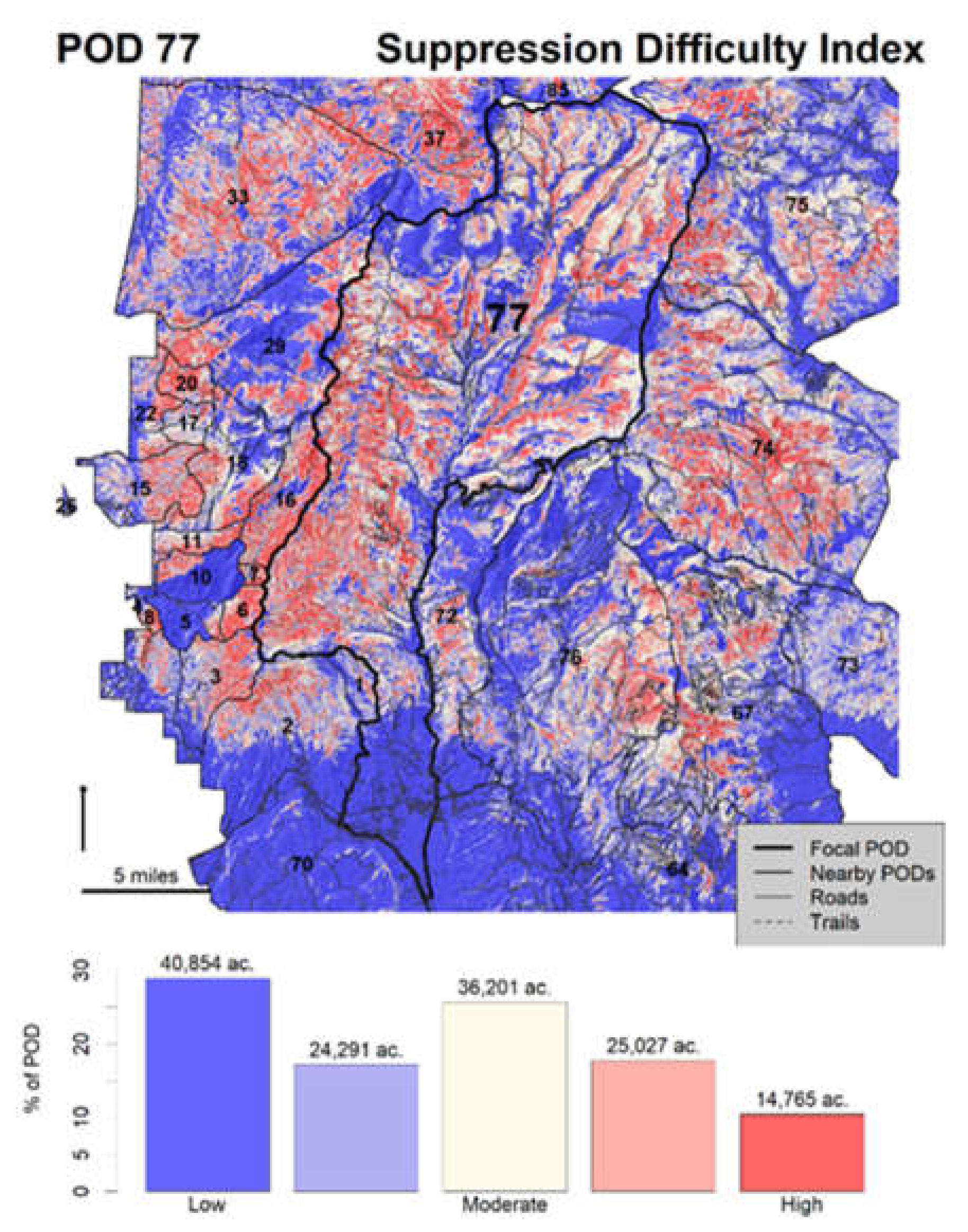
| Burnable area | Topography | Flame length probability | Net value change * | Strategic response zone * | Suppression difficulty |
| Treatment history | |||||
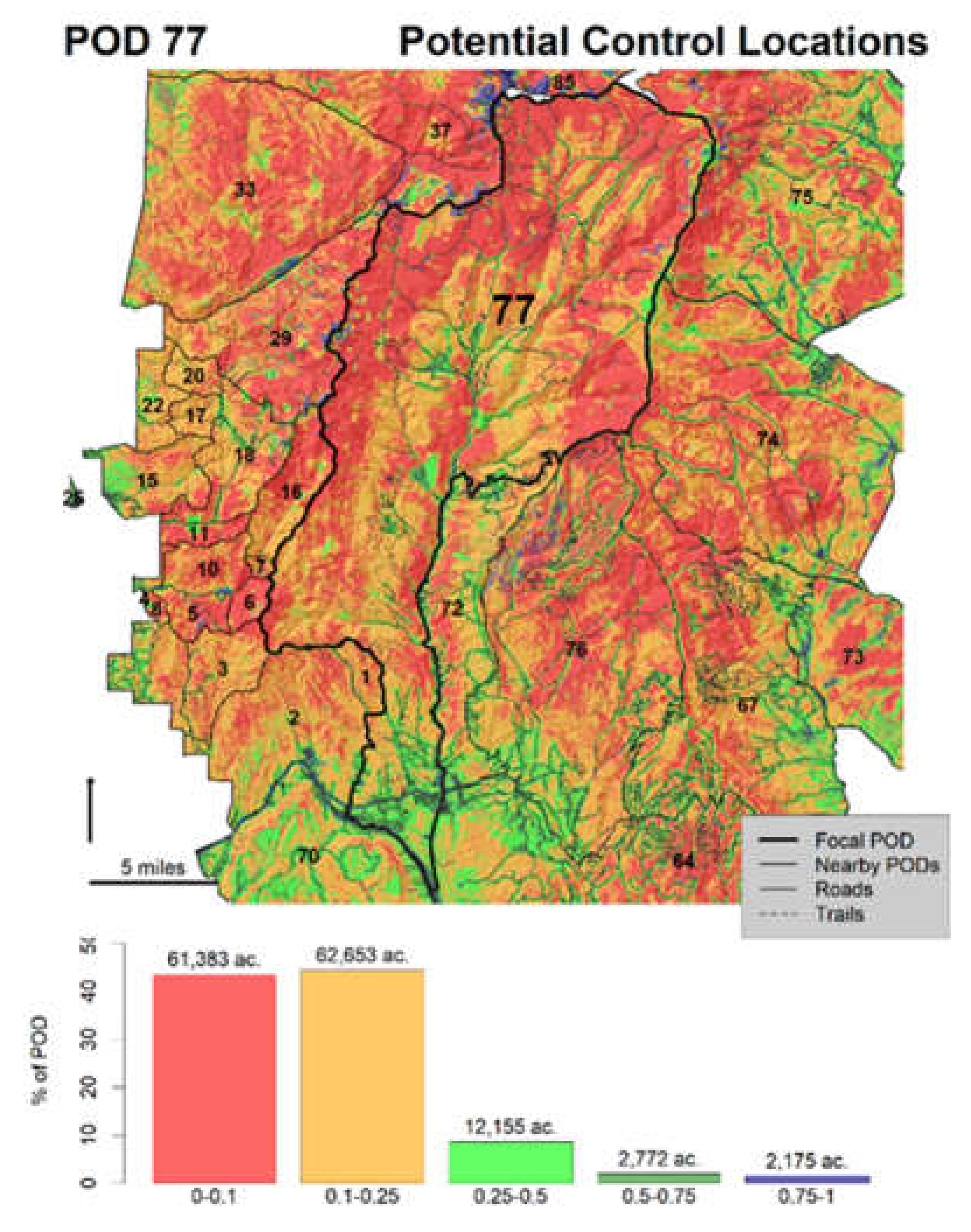
| Potential control locations * |
© 2020 by the authors. Licensee MDPI, Basel, Switzerland. This article is an open access article distributed under the terms and conditions of the Creative Commons Attribution (CC BY) license (http://creativecommons.org/licenses/by/4.0/).
Share and Cite
Thompson, M.P.; Gannon, B.M.; Caggiano, M.D.; O’Connor, C.D.; Brough, A.; Gilbertson-Day, J.W.; Scott, J.H. Prototyping a Geospatial Atlas for Wildfire Planning and Management. Forests 2020, 11, 909. https://doi.org/10.3390/f11090909
Thompson MP, Gannon BM, Caggiano MD, O’Connor CD, Brough A, Gilbertson-Day JW, Scott JH. Prototyping a Geospatial Atlas for Wildfire Planning and Management. Forests. 2020; 11(9):909. https://doi.org/10.3390/f11090909
Chicago/Turabian StyleThompson, Matthew P., Benjamin M. Gannon, Michael D. Caggiano, Christopher D. O’Connor, April Brough, Julie W. Gilbertson-Day, and Joe H. Scott. 2020. "Prototyping a Geospatial Atlas for Wildfire Planning and Management" Forests 11, no. 9: 909. https://doi.org/10.3390/f11090909
APA StyleThompson, M. P., Gannon, B. M., Caggiano, M. D., O’Connor, C. D., Brough, A., Gilbertson-Day, J. W., & Scott, J. H. (2020). Prototyping a Geospatial Atlas for Wildfire Planning and Management. Forests, 11(9), 909. https://doi.org/10.3390/f11090909