Review

Engineering Methods of Forest Environment Protection against Meteorological Drought in Poland

by
Andrzej Czerniak
1,
Sylwester Grajewski
1,
Anna Krysztofiak-Kaniewska
1,
Ewa E. Kurowska
1,*,
Bernard Okoński
1,
Małgorzata Górna
2 and
Rafał Borkowski
1
1
Department of Forest Engineering, Faculty of Forestry, Poznań University of Life Sciences, 60-623 Poznań, Poland
2
Greater Poland National Park, 62-050 Mosina, Poland
*
Author to whom correspondence should be addressed.
Forests 2020, 11(6), 614; https://doi.org/10.3390/f11060614
Submission received: 28 April 2020 / Revised: 23 May 2020 / Accepted: 25 May 2020 / Published: 1 June 2020
(This article belongs to the Section Forest Ecology and Management)

Abstract

:
The forest cover in Poland reaches almost 30% of the country’s area. Polish forests are characterized by high biodiversity. Unfortunately, in recent years, the forests of Central Europe have been affected by climate change problems, in particular meteorological drought. In Poland, even those stands which consist of species that were widely recognized as drought tolerant and easily adaptable to environmental changes are beginning to die. The article presents engineering methods applicable to forest environment protection, largely developed at the University of Life Sciences in Poznań and implemented by the State Forests—National Forest Holding in Poland, to minimize the effects of drought. Among the issues raised are ways to protect forests against fires, modern technologies for fire road surface construction and small-scale water retention in forests. A comprehensive solution to problems related to progressive drought is a must. Scientists and foresters are observing the dying of large areas of stands and, at the same time, intensification of wildlife migration due to the search for new habitats as a consequence of the drought. Therefore, the issue of building animal crossings during the current dynamic expansion of the road network in Poland has also been presented in the paper. Another subject pointed to in the text is forest tourism. Forests provide opportunities for recreation and rest to society. However, the increasing tourist pressure in some regions may cause adverse environmental effects. Finally, the paper shows some examples of supporting forest environment protection using remote sensing techniques. Generally, the aim of the paper is to present experiences and comprehensive solutions implemented in Poland.

1. Introduction

At present, the forested area in Poland exceeds 9.2 million ha and is steadily increasing, from 21% of the country’s land area in 1945 to 29.6% currently [1]. The vast majority of forests are state-owned, of which over 7.3 million ha are administered by the State Forests—National Forest Holding (in short: State Forests). The State Forests’ core activity is sustainable forest management. The areas administered by the State Forests are accessible and forest products, such as berries and mushrooms, may be freely picked there. The State Forests represent the State Treasury of Poland and act on its behalf in property management. The organization also controls timber harvesting in private forests. The State Forests closely cooperate with research institutions both in the field of environmental protection and forest management. Especially in the current climate conditions characterized by long periods of rainfall shortage and, on the other hand, extreme weather events (torrential rainfall, storms), often with catastrophic effects (floods, fires, landslides), cooperation between forest management professionals and scientific communities is extremely important [2,3,4,5,6,7,8,9,10,11]. Such joint work enables the active seeking for practical ways to prevent negative climatic phenomena and to contribute to the mitigation of their effects.
In the field of forest engineering, the primary research directions inherent in preventing and mitigating the impacts of adverse climatic and weather conditions on the forest environment currently conducted for the State Forests are related to forest firefighting infrastructure (fire roads, forest landing fields, water intake points), water management in forests and eco-engineering.
Forest engineering methods are important elements of the forest environment support system; they are necessary for adapting forest road networks for fire-fighting purposes, planning and building infrastructure to reduce water outflow, increasing water retention in forests, and developing infrastructure that prevents the fragmentation of forest habitats and ecosystems. The article presents some significant research achievements enabling the protection of the forest environment and sustainable management of Polish forests in conditions of prolonged drought observed in Poland. The effects of a number of works on specific problems affecting selected regions of the country were shortly described; the locations of the presented projects are shown in Figure 1.

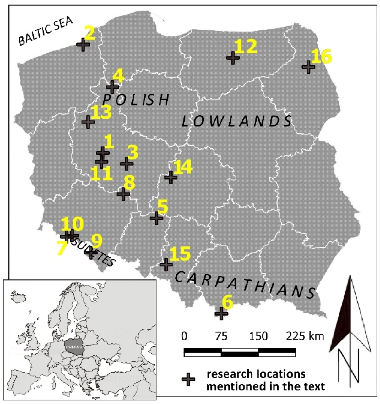
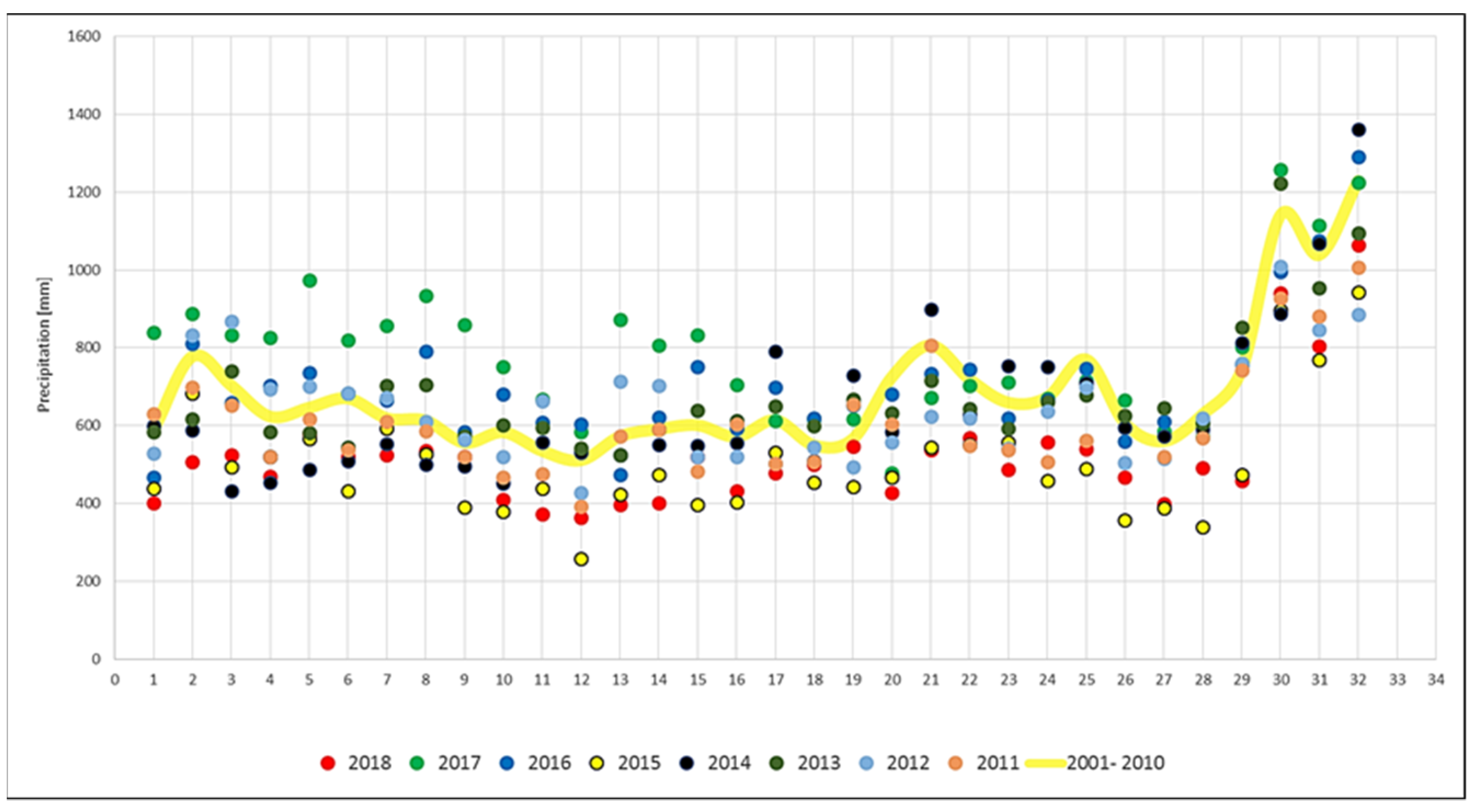
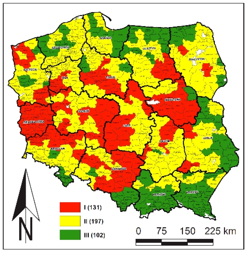
2. Water Conditions in Polish Forests

Forest ecosystems can access water from many sources, while a number of hydrologic processes might be employed. In some forest ecosystems, vegetation solely uses the precipitation stored in the saturation zone of soil (vadose zone), e.g., in forests growing on uplands covered by thick, permeable soils, where the ground water level is well below the active zone of the roots [12]. These forms of ecosystems occur over vast areas of the Central and East European Plains covered by soils developed on thick sand and gravel formations [13]. An example of a very water-poor forest complex is the Noteć Forest, covering about 1372 km2 in the western part of Poland. The forest stands growing on the dune area between two rivers, Warta and Noteć, stretches for over 100 km, while an average width of the zone is 20 km. The average height of the dunes is about 20–30 m, and the maximum—about 50 m. The forest stand comes mainly from artificial plantings initiated on a large scale in the second half of the 19th century [14]. The forest consists of 70-year-old pine stands with a small proportion of birch. On 10 August 1992, a huge fire broke out in the Noteć Forest, in which 5770 ha of forest burned down [15].
Sometimes ecosystems use precipitation coupled with a substantial share of water derived from the other sources available at different time and spatial scales. These sources of water can be the groundwater of the zone of saturation, surface floodwater or water intercepted from mist [12].
Forests growing in river valleys are unique ecosystems in terms of both hydrologic specificity and biological richness [16,17,18,19]. The ecologically important elements of river regime are the temporal distribution of the high and low water periods and its connectivity with groundwater in the river valley, as well as the temporal distribution of flooding events [18,20,21,22]. A fundamental ecological importance for riverine forests is attached to the temporal stability of river regime elements over longer periods [23,24,25,26,27,28,29]. Perennial rivers might be perceived as relatively stable sources of water for vegetation of river valleys. Nevertheless, river flow and water stages may vary significantly even for the rivers whose regime has not been transformed by humans, under relatively stable and favorable hydroclimatic conditions, e.g., those occurring in some river basins of the rainforest zone [30,31].
The variability of river flow can result in temporal water surplus, limited water availability or even acute scarcity during some periods. The events of strong soil drought can occur not only on uplands, but also on active terraces close to river channels [27,31,32]. Drought can be the effect of a prolonged decrease of precipitation (reduced input of water to an ecosystem) and an increase of evapotranspiration (lifted output of water from the ecosystem). Those processes can coincide temporarily or occur separately. The main physical driver modulating evapotranspiration is temperature. Increase of temperature, frequency of warm and hot events, as well as periods of precipitation shortage observed at various spatial units, particularly since the middle of the 20th century, have increased damages to forests, manifested as reduced tree growth, decreased health status, and—in particularly unfavorable habitat conditions—dying trees [9,32,33,34]. According to research by the Polish Institute of Meteorology and Water Management – National Research Institute, droughts occur quite often in Poland, but most often they cover only the meteorological drought phase. Droughts that continue to reach the phase of hydrological drought cover larger areas of the country and are less common. In recent decades, such droughts occurred in 1982, 1983, 1992, 1993, 1994, 2000 and 2003. Then the drought continued in 2005–2006. In the second decade of the 21st century, significant periods of drought occurred in 2011, 2015, 2018 (Figure 2) and in the months at the turn of 2019 and 2020 [9,35,36]. The periods of drought, particularly the one of 2015, clearly left their negative mark on the condition of the stands, as indicated in the experts’ reports [9,37,38,39,40,41].
Anthropogenic stress on river valley ecosystems started as early as in prehistoric times. The river neighborhood was the natural location of the first permanent settlements, expanded later to settlement networks with developed agriculture, and later industry [42,43,44]. Various human activities resulted in the weakening, transformation, and the disintegration of river valley ecosystems occurred along different time horizons [42,43,45]. As a result, the natural river regime and hydrologic conditions in river valleys have been disturbed. These factors influenced the change of conditions of growth and development of natural riverine forests, caused a process of vegetation transformation in many locations, and, in consequence, an increase of vulnerability to pests, diseases and drought [46,47,48,49].
Tree ring traits are good indicators of the effect of hydroclimatic parameters on forests in river valleys [34,50]. On this basis, zones of uniform tree growth response to hydroclimatic factors (e.g., to indices of drought susceptibility Standardized Precipitation-Evapotranspiration Index (SPEI), Self-Calibrated Palmer Drought Severity Index (scPDSI)) in riverine forests were found. Pedunculate oak (Quercus robur L.) forests were investigated because the species is one of the main tree components of forests in temperate climates across Europe. The zonation can be applied in forest management for the indication of forest habitat moisture and drought-prone regions for planning forest operations, e.g., selecting the species composition of forest stands. The spatial and temporal dynamics of these zones may also be used to assess the impact of river management operations (e.g., hydroengineering constructions) on ecosystems in river valleys. The zonation may provide an assessment measure for evaluating the effects of projects aimed at the protection and restoration of floodplain forests and riverine ecosystems [51].
Since the beginning of the 1980s, mass dying of oak stands has been observed in Europe and other parts of the world [52,53,54,55,56]. Currently in Poland, oak stands cover an area of about 630,000 ha, which is almost 7% of the total forest area. One of the reasons for oak decline in floodplains is the change in hydrological conditions caused by the regulation of river flows. The large storage reservoirs built for flood protection control water level in rivers, and thus reduce the watering of the oxbow lakes and floodplains. One example of research into the causes of oak stand weakening in Poland was the study of annual tree ring increment as the indicator of the health state of oaks overgrowing the flood plains near the Jeziorsko reservoir in Central Poland. Analyses comparing average annual increments of oak wood indicate that in the years with average and high precipitation, the width of the rings did not indicate any poor health condition of the stand, despite the lack of periodic flooding. The mass dying of oaks occurred only when the amount of precipitation during the vegetative periods was definitely lower than the average. An additional negative factor was the unfavorable chemistry of atmospheric precipitation in dry years [57]. Weakened by a scarcity of water, oak stands have become susceptible to fungal diseases and insect outbreaks, mainly the oak splendour beetle (Agrilus biguttatus).
Currently, as the impact of drought is getting stronger, there is a significant need to preserve the wetlands which are the most valuable water areas. In the past, wetlands occupied large areas in Europe, but in recent centuries they have been drained and dried up, and transformed into pastures and arable fields. Wetlands in Poland currently cover an area of approximately 43,000 km2, of which over 12,000 km2 falls on peat bogs [58]. In order to protect such areas, the authors have developed a strategy focused in particular on counteracting the outflow of water from forest areas through the use of various technical measures, including, among other things, the construction of automatic water damming devices (an example is shown in Figure 3 further in the text) [59].

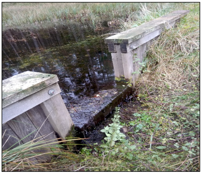
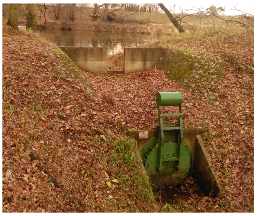
3. Small Water Retention in Forests

In Poland, 87.5% of the total water resources are waters originating in Poland (i.e., autochthonous waters), and the remaining 12.5% is water inflow from outside the country. The long-term mean total surface water resources from all sources add up to 61.6 km3. Out of these resources, 95.5% flow directly to the Baltic Sea and the remainder to neighboring countries. Artificial retention reservoirs have a small capacity; they can only store 5 billion m3 of water (6.5% of the annual outflow) [60].
As a result, Poland ranks as one of the last countries in Europe in terms of available water resources. In view of the very small, frequently contaminated water resources and their multiannual, seasonal and spatial variation, it is necessary to develop higher water retention. At present, the main threat is habitat overdrying. Adverse changes in water relations lead to marked transformations in tree stands, affecting not only species composition, but also resulting in the deterioration of tree conditions.
Periodical water shortages and surpluses observed in forest ecosystems may be mitigated using various forest management methods and technical infrastructure. Forest complexes are important elements in regulating water circulation in a river catchment. Increasing the retention capacity of forested areas may contribute to a considerable extent to the improvement of the water balance structure.
The term “small retention” was used for the first time in Poland to describe small water bodies in the 1970s [61,62]. At present, it covers all engineering and non-engineering (or hard and soft engineering) methods aiming at improving the water balance in the catchment by increasing its natural retention capacity [63]. According to Mioduszewski [64], small retention may apply to all types of water storage with no ongoing regulation of retention capacity. In other words, actions improving the catchment water balance and increasing water resources primarily due to the transformation of the rapid surface run-off into a slow underground run-off may be classified as small retention.
Engineering objects within the small retention system include fords, riffles, dikes, artificial damming steps (Figure 3), outlet boxes, solid or diversion weirs, overspills, fish ladders, damming culverts, earthen dams, gates, ditches and retention reservoirs. The difference between retention in large reservoirs and small retention is that small retention is natural and thus beyond control. It is difficult to measure its capacity. Natural small retention facilities are not equipped with measuring devices and the amount of water stored in them is not controllable [62]. An empirical example of engineering development of a catchment may be provided by the Lipka Forest District, with its hard engineering measures for small retention. The mean value of time constant (T) for flood waves before the engineering development of the investigated watercourse located within the Lipka Forest District was 2.75 h, whereas after the engineering measures were implemented it is 4.13 h. This means that the time constant related to catchment inertia increased by approx. 50%. Thus, it may be hypothesized that the duration of flood waves in the catchment has been considerably extended thanks to the watercourse development using six gates [65].
The greatest dependence on changes in water relations is observed in the case of forests growing in marshy and moist habitats [66]. All types of wetland habitats and marshes are highly important elements of the environment. They constitute unique biotopes, characterized by unprecedented biodiversity. They exhibit the capacity to purify water and act as natural retention. Floodplain forests are some of the richest ecosystems in deciduous forests in Poland. According to the map of potential vegetation, floodplain forests could occupy as much as nearly 9% of the forest area in Poland, however, they cover only 0.2% [67]. Another empirical example may be provided by the efforts to preserve the “Uroczysko Warta” (a forest situated on the floodplain terrace between the Warta and Lutynia rivers, see location in Figure 1) and its nature value through the construction of a system of hydraulic structures improving water relations in the area. These structures included damming steps on the Lutynia river, culverted with backflow preventers (Figure 4), which facilitate the discharge of flood and dammed waters of the Warta river to oxbow lakes and prevent their return to the Warta, along with stop gates making it possible to manually control water levels in oxbow lakes [66].
Engineering facilities as a component of the small retention system may also include structures slowing water flow constructed by beavers (Figure 5).
Another measure changing water relations is the implementation of soft engineering elements. This refers to the introduction of woody, shrubby, and/or herbaceous vegetation with species composition and spacing appropriate for their role, e.g., protection of riverbanks or lake shorelines against the destructive impact of wind and riverside areas against flood waters; dissipation of current force; preservation of escarpments and landslides; protection against erosion and excessive surface run-off; increased retention potential; reclamation of degraded areas, and sanitation. Soft engineering supplements hard engineering measures when biological elements supplement hydraulic structures or other engineering objects [69].
When designing sites for the point discharge structures and small retention objects, we need to consider the historical background of a given area and analyze the area in terms of locations of natural water bodies or wetlands. In order to indicate the appropriate locations for small water retention objects which will provide the best efficiency, one can apply the methodology of analyzing potential retention capacity of the catchment. It is based on the allocation of codes representing small, medium or large potential retention capacity. The water retention capacity in a given area is controlled mainly by climatic factors; however, there are a number of other important physical and geographical parameters. These non-climatic parameters define the so-called potential retention capacity [70,71]. The essence of the method is to assign one parameter to each elementary surface, which takes into account the combined impact of the most significant, identifiable, physical and geographical, non-climatic parameters on potential retention capacity. Eight parameters are calculated for each elementary surface: mean slope, average thickness of the aquifer, average soil filtration coefficient, distance from the watercourse network, distance from stagnant waters, dominant habitat, dominant species of stands and the dominant age class of stands [72]. Originally, rasters were considered to be an elementary surface—square surface panels with a side of 0.5 km [73]. In subsequent analyses, inferences were made based on the smallest elementary forest area, which is the subdivision (Figure 6) [68]. This procedure significantly facilitates obtaining the necessary output data for the model, which can now be obtained from the forest numerical map that all Forest Districts in Poland have.
A crucial and indispensable element accompanying the small retention engineering facilities since the beginning of their operation is an adequate and regular inventory, along with the maintenance enabling their upkeep [74].

4. Forest Fire Protection

One of the most tragic but also spectacular experiences confirming the great importance of forest road network for firefighting was the fire in the Rudy Raciborskie Forest District in 1992—the largest fire which has taken place in Poland and then in Central Europe since World War II. The fire lasted from 26 to 30 August and destroyed 9062 ha of forest area [75]. Currently, organizational units of the State Forests—National Forest Holding work on spatial optimization of road systems, also including their number, based on specially prepared forest road plans. As a result, forest districts are provided with a body of information to facilitate future operations. The main objective of these forest road plans is to precede investment processes with assessment of their economic rationale manifested, among other things, in planned management and protection operations. The road network is optimized by establishing the course of required roads, i.e., trunk roads, byways, access roads for machines, as well as matching maintenance and rehabilitation technologies adequate to the needs.
An extremely important element of the fire protection infrastructure in every forest complex is a sufficiently dense network of fire roads. The requirement to identify roads as fire roads within the forest road network and to maintain their condition up to a certain technical standard was introduced in the State Forests organizational units by the “Instruction on fire protection in forested areas” of 1996 and 2020 [76,77]. The information and requirements included in the instruction resulted, among others, from research carried out by the authors of the current paper. It was established that the distance between any point located in the forest and the nearest public road (excluding highways and express roads) or a forest road classified as a fire road should not exceed 0.75 or 1.50 km depending on the adopted fire hazard category for a given forest (Figure 7) [77,78,79,80]. Fire roads also serve the function of the primary grid for the transportation network necessary to carry out all tasks in a given forest complex. According to data from 2015, within the area administered by the State Forests there are almost 107,000 km of forest roads, of which as much as 47% serve the function of fire roads [81,82]. Transport problems observed in Polish forests resulted not from a lack of roads, since their density indexes were relatively high and comparable with those of other European countries, but rather from the very low percentage of paved roads [81,82]. This has facilitated a considerable investment on the forest road infrastructure being made in the following years.
At present, research in the Department of Forest Engineering focuses on the verification of current regulations of public law and specific professional guidelines concerning fire roads in relation to the requirements to be met for currently used firefighting and rescue vehicles of fire brigades, as well as applied tactics and technologies of forest firefighting [83,84]. These refer in particular to:
  • Optimization of road network density and geometrical parameters of forest roads, including fire roads [81,82,83]. The high construction costs of many kilometers of forest roads cause the need to optimize their density and geometrical parameters as well, while adapting to requirements on effective and safe rescue operations.
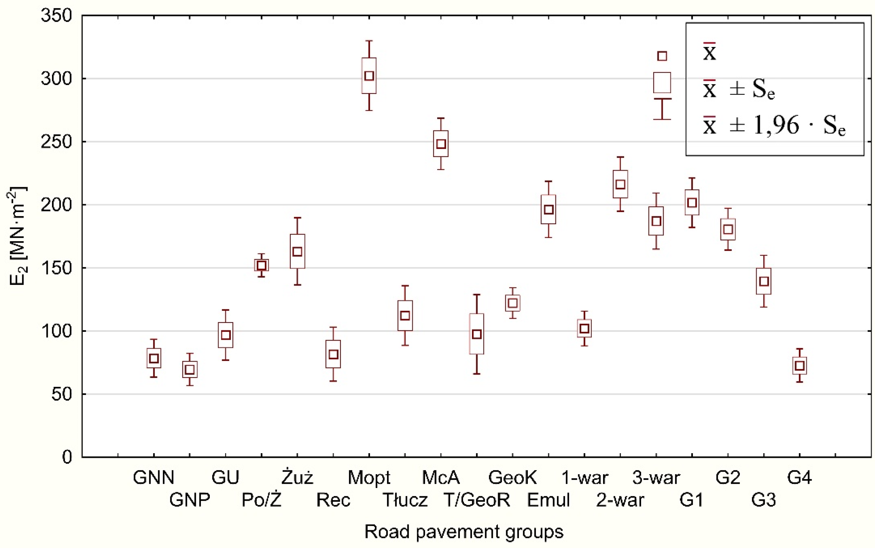
  • Tests of load-bearing capacity of forest fire roads—the existing ones, as well as the newly built ones (Figure 8). The variability of fire roads capacity parameters is still significant and in many cases insufficient; this applies first of all to dirt road surfaces and roads built on loose substrate (G3, G4) [83,85].
  • Changes in the parameters of bearing capacity of forest road surfaces due to heavy rainfall [84,86]. Recognizing the risk of road serviceability loss caused by excessive humidity of road sub-grade and unbound layers of road construction, together with counteracting techniques, is an important direction of research nowadays, when an increase in the frequency of extreme weather events is observed.
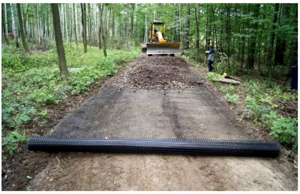
  • Development of new technologies increasing the load-bearing capacity of road surfaces (additional discussion of this issue further in the text).
  • Improvement of supervision methods and commissioning of intensively constructed and redeveloped surfaces of fire roads. This applies to, among other things, searching for relationships between the results of load-bearing capacity tests carried out with the use of static plates, and the results of measurements taken with light falling weight deflectometers (Figure 9). Success in this area would give rise to a reduction or even the elimination of widely used, but time-consuming and uncomfortable to operate, load capacity tests with static plates for quick measurements with light dynamic plates.
The functioning of the fire protection system in Polish forests may be considered highly effective. The mean area affected by a single fire in Poland is relatively small and shows a downward trend [86]. The mean area of a single fire in forests administered by the State Forests, covering the main organizational and financial burden of fire protection in Polish forests, is almost twice as small as in private forests [87]. In relation to climate change affecting Poland, it is necessary to intensify actions minimizing fire hazard in forests.

5. Advanced Road Surface Construction Technologies for Forest Fire Roads

For many years now, the authors of the current paper have cooperated with the forestry experimental stations, the organizational units of the State Forests, and business entities, when conducting tests on materials and technological solutions potentially applicable in forest road engineering [89,90,91,92,93,94,95]. They are not only laboratory tests, but also field tests in specially prepared experimental test roads [96,97,98,99].
In Polish forest road engineering, the predominantly used technologies are based on crushed-stone aggregate of 0/31.5 mm and 0/63 mm in size. Typically used aggregate is produced from crushed solid rock and anthropogenic aggregate. Since the purchase and transport costs of aggregate are high, it is advisable to use less costly solutions. In order to provide road surface made of aggregate with the required load-bearing capacity, the layers have to retain a constant design thickness throughout the service life of the road. In the case of subgrade from aggregate on soils of low load-bearing capacity (clays, loams, fine sands, organic soils), it is also necessary to isolate the expensive material from the subsoil.
To date, various solutions have been used, e.g., fascine layers, isolating sand layers, geotextiles. Fascine layers have to be laid manually; additionally, fascine is not a homogeneous material. In turn, sand layers are relatively effective, but their construction is costly and time-consuming. Geotextiles in susceptible structures tend to undergo permanent deflections. Studies indicate that in forest conditions geotextiles and geogrids (so-called rigid knot geogrids) are most effective [100]. In contrast to geocells, they may be installed fast and the cost is relatively low. The application of geogrids results in saving of aggregate and at commissioning makes it easier to identify the thickness of the aggregate layer laid on the geotextile (Figure 10).
Crushed-stone aggregate structures in forests are most frequently left with no asphalt or concrete layer and thus they constitute road surfaces. Since these surfaces are water permeable, the plasticized subgrade contributes to surface rutting.
In the case of forest districts located at large distances from crushed-stone aggregate mines, the transport-related costs of these materials are very high. For this reason, it is necessary to search for other road engineering technologies, which are based on crushed stones to a lesser degree and use local materials, with no need to incur costs of long-distance transport.
Road slabs may be produced based on locally procured aggregates. In contrast to crushed-stone aggregate, the quality of slabs may be easily evaluated. Their producer is responsible for their quality. Pieces damaged during use may be easily replaced. Road surfaces made from concrete slabs are durable and may be installed fast. Permanent or temporary surfaces may be constructed on areas affected by natural disasters. An example of an innovative slab is the one resulting from the cooperation between the authors and Betard LLC—it is a reinforced concrete solid self-draining surface road slab (PDS). Until now, the so-called flat poorly draining slabs were used. They tended to shift, particularly on uphill roads, as at greater grade line slopes the road-slab adhesion decreased. The surface of the new slab has a pre-formed single-sided slope (2%). The interior side adjacent to the road axis features a deviation from the vertical, thanks to which the slab is anchored after filling of the central zone between slabs using soil or aggregate. Additionally, the slab may have a shallow trapezoid furrow to drain water. This slab type is particularly useful in mountain areas. The furrows act similarly to open-top culverts. That road slab is now subject to a patent claim to the Patent Office of the Republic of Poland for an invention entitled “Self-draining road slab, dedicated particularly to construction of permanent or temporary two-track roads”.
For many years, the authors of the paper, as representatives of the research institution (Poznań University of Life Sciences), have been participated in the preparation of formal aspects of capital investments by organizational units of the State Forests in forest road engineering [81,101]. The research institution also contributes to solving problems reported by forest districts, forest management, and forest geodesy offices or economic entities in issues concerning such investments. It is worth noting that the authors of the paper acts in favor of the popularization of new technological solutions and engineering technologies for forest road surfaces and the implementation of good engineering practices [85,102,103].

6. Tourism Management

There are three main functions of forests, namely, nature conservation, economic and social function. The latter function is related to providing a wide range of tourism products and the development of environmental education. In times of intensive digital transformation and lifestyle changes in societies, as well as during the current crisis of a global pandemic threat, forest areas take on a recreational function for society and even provide the possibility of “forest therapy”.
The dynamic development of infrastructure, educational activities and promotion of nature of forested areas have contributed to a systematic increase in tourism traffic in Poland [104,105]. While interest in the use of forest value is generally a positive phenomenon in terms of human health and welfare, from an environmental point of view, forest tourism may be problematic if it is concentrated in small, more attractive areas [106]. The negative impact on the environment is intensified in conditions of reduced stands stability, associated, for example, with hydroclimatic changes. Currently, the problem is becoming more significant as the country is affected by drought, observed in Poland for several years. Tourist traffic may constitute a fire hazard; therefore, it is very important to properly target it to the safer areas equipped with fire-fighting facilities and devices.
Excessive concentration of tourist activity in small, attractive areas is observed in Poland, particularly in national parks, within the specific timeframe: in the summer season for 2–3 holiday months and during the so-called long weekends. According to official statistics, at the end of 2018, the greatest number of tourists was recorded in the Tatra Mountains National Park (4 million) and in the Karkonosze Mountains National Park (2 million) [1].
The main actions in the scope of engineering for the prevention of negative effects caused by mass tourist traffic, its elimination and actions aiming at a decrease in the tourism impact on species and habitats include
  • influencing the direction of tourism traffic on established trails and stopping further treading on habitats thanks to properly designed trails (adequate spatial planning and application of proper parameters when designing trail, small tourism infrastructure, protection measures);
  • renovation of tourism trails—trail surface rehabilitation, protection against erosion in degraded zones in the vicinity of trails;
  • proper trail labelling and minimization of the risk of tourists treading and forming new paths in the vegetation other than the main trail;
  • providing adequate drainage.
For several years now, the authors of this paper have been preparing tourism management plans, i.e., written reports on the current state of tourism development in forests and on the actions planned to address tourist traffic intensity, as well as providing guidelines for all forest engineering works, applicable also in tourism management of forests. Examples of such tourism management plans include those for the Promotion Forest Complex of the Barycz River Valley (a lowland forest area) [38] and the Table Mountains National Park (a mountain forest area) [107], as well as the concept proposal for tourism management of the forest districts in the entire Kłodzko Region (see locations of the works in Figure 1), [39,40,41]. Within the executed projects, extensive works were conducted including both field studies and office works, comprising the development of a vast database in the GIS environment; questionnaire surveys have also been administered among tourists, the local population, local government bodies and the management of the forest districts. The most important activities included analyses of the fluctuation and intensity of current tourist traffic by applying various methods; field inventory surveys; valuation of the current infrastructure (trails, roads, outdoor tourist facilities); analyses of forest road line capacity; valuation of tourism attractions; analyses of stand attractiveness and stability; allocation of areas for temporary or permanent exclusion from tourism use, as well as indication of new areas which may be open to tourist traffic in order to dissipate its load.
In such prepared studies based on the conducted analyses, many solutions were proposed to ensure sustainable tourism development, which would prove beneficial both for the natural environment and the tourists. Assessment of the stability of stands in the forest districts and national parks being under research is one of the most important elements of the created tourism management plans. According to the method proposed by R. Jaszczak (described in [39,40,41,108]), for the comprehensive assessment (qualitative and quantitative) the following elements of forest environment are taken into account: species composition of stands; conformity of species composition to the stand type; degree of damage (caused by wind, snow, disturbed water relations, insects, fungi, and others); scale of salvage logging (in m3/ha); stand structure (single-layer, two-layer, multi-layer); slenderness (calculated with a use of total height and DBH—diameter outside bark at 1.3 m above ground). The stability assessment is carried out in two age classes of the stand. In this type analyses made for the Kłodzko region in 2019, the occurrence of large areas of low tree stand stability or threat to stability was found, which largely resulted from the hydrological drought in 2015. The effects of stand stability analyses, presented in the form of maps, provide a tool for management in forests, including control of excessive tourist traffic, which should be diverted away from the areas at risk; for example, from areas weakened by drought or subjected to another natural hazard. So far, in the Kłodzko region, the decision to change the course of tourist routes due to the threat to the stand’s stability caused by the drought (which still continued in 2019), was taken by the authorities of the Table Mountains National Park. The Park (approx. 63 km2) accounts for approx. 4% of the Kłodzko region area and is one of the most crowded tourist destinations. Tourist traffic in the park is characterized by high spatial and temporal concentrations. In 2017, there were 871,000 tourist visits to the Park, most of them recorded during the summer holidays (192,000 in July and 191,000 in August) and in spring (164,000 in May, 132,000 in June), which constituted approximately 78% of all visits throughout the year [107]. The change of the course of tourist routes in the Table Mountains concerned the two particular areas within the Mountains which are extremely attractive to tourists, and are therefore subjected to increased anthropopressure; at the same time, the areas are covered, in whole or in part, with a tree stand with strongly reduced stability.

7. Wildlife Passages

Compared to many other European countries, Poland is characterized by considerable biodiversity [108,109]. Areas of the greatest nature value included in the European NATURA 2000 network are distributed throughout the country. Due to the specific characteristics of road investments being linear in their course, in many cases it is impossible to bypass these areas of outstanding nature value.
Unrestricted wildlife migration is the basis for the sustainable existence of individual populations. Currently, the migration intensity of large wild animals is increasing in Poland [110]. The main reasons, in addition to industrial pressure, are the pressure of predators (in particular the increasing number of wolves), and changing environmental conditions, e.g., the drying out of small water reservoirs used as watering holes by wildlife. Disrupting these migration corridors results in the formation of isolated subpopulations. Inbreeding may lead to the manifestation of unfavorable recessive alleles and a reduction of genetic diversity within these subpopulations as a result of accelerated genetic drift. In isolated groups we observe increased susceptibility to epizootics and a drastic decrease in the size of local populations. This is due to the reproduction of related individuals which leads to inbreeding depression (reduced fertility and fecundity, reduced resistance to diseases and reduced vitality) [111].
The fencing of express roads and motorways as well as high-speed rail tracks, connected with the requirements of traffic safety, produces barriers and prevents animal migration. For many years now, studies conducted at the Department of Forest Engineering, the Poznań University of Life Sciences, have concerned the analyses of traffic events involving wildlife, functionality of wildlife overpass and underpass crossings, alongside developing indications and guidelines for the construction and structure of these passages. These studies were summarized in two scientific monographs: “Functionality of wildlife overpasses” [112] and “Traffic events involving wildlife on public roads” [113]—both in Polish.
Migration continuity along ecological corridors intersected by communication routes is provided by the construction of wildlife crossings. The first ”green bridge” was constructed in France in 1962 at a location where a motorway cuts through the Fontainebleau forest outside Paris. Wildlife crossings are divided into underpasses and overpasses. Currently, the predominant concept in Europe is to construct overpasses as self-supporting earthen embankments reinforced with a corrugated iron structure. Building animal passages is the primary element minimizing the environmental impact of road and railway structures.
Railway tracks are also dangerous obstacles for wildlife. Currently, the so-called “UOZ” device (UOZ-1 Animal Protection Device [114]) is being tested to warn animals migrating across railway tracks. Before a train passes the location, this device emits various sounds, such as imitation of hare distress sounds or jay alarm calls, thus reducing the number of train collisions with animals.
Wildlife passages are expensive objects. For this reason, it is necessary to monitor the functionality of these wildlife crossings. The aim of such monitoring is to verify the effectiveness of the adopted engineering and biological solutions. When no migration is observed, a costly redevelopment of such structures is required.
In order to precisely identify the pattern of migrations, track the duration of the animals’ stay at the crossing, as well as the behavior of animals during that time, the first Polish prototype monitoring system (both stationary and mobile) was developed and used over a decade ago at the wildlife crossing in the Greater Poland National Park. The main element of the monitoring system is a wireless camera recording movement above 15 cm from the passage surface, and transmitting images using the GSM network, which are archived on an external server.
Analyses of recorded film sequences showed that a properly designed, developed, and managed overpass is accepted by wild animals and, as such, ensures the continuity of migration corridors intersected by a road with high traffic intensity. The wildlife crossing was used by both large game and predators. In 2017, the passage was used for the migration of 7788 red deer (including 4144 stags, 2555 hinds, 1089 calves), 7722 wild boars (4288 adults and 3434 young), 748 roe deer (including 377 bucks, 274 does and 97 calves), 1248 foxes, 491 badgers, 32 raccoon dogs, 50 martens, as well as 126 other events involving wildlife; a total of 18 205 animals used the wildlife passage. Among the 126 “other events”, the following migrations were observed: 29 hares, 7 polecats, 2 fallow deer, 4 bats, 1 raccoon, etc. (Table 1).
In almost each analyzed month, over 1000 animals were observed at the crossing (except for July—722, August—738 and December—507). Over 2000 animals per month were recorded in January, March and November. March was the record month with 2787 recorded events.
In 2018, the animal passage was used by 7145 red deer (including 3025 stags, 2982 hinds, 1138 calves), 7528 wild boars (3202 adults and 4326 young), 2450 roe deer (2175 bucks, 258 does and 17 calves), 1452 foxes, 398 badgers, 52 raccoon dogs, 41 martens, along with 230 other events; a total of 19,296 animals used this passage. Among the 230 “other events”, the following migrations were recorded: 12 hares, 3 raccoons, 3 fallow deer, 66 domestic cats, 15 dogs, 36 horses from nearby studs, as well as 63 hiking tourists and 29 cyclists (Table 2).
On 30 March 2018 at 08:06, a wolf was recorded when crossing the wildlife passage (the third such event in the park’s history), while on 21 September 2018 at 00:31, an elk appeared at the wildlife crossing for the first time.
From January to August, in each analyzed month over 1000 animals were recorded at the wildlife crossing (except for May—596 and June—760 animals). From September to December it was over 2000 animals a month, with the record number of recorded events in September (2316).
Studies showed that the model wildlife passage was fully accepted by wildlife, even by wolves (Figure 11 and Figure 12). Animals were frequently grazing at the passage, wild boars and red deer even dueled despite the intensive vehicle traffic below. It was also found that even a single case of baiting with feed and salt paste is effective in luring wildlife to the passage. In the course of that research project, numerous planting designs were established in the form of bioclusters composed of sand dune willow, wild pears, Jerusalem artichoke, etc.
The methodology of monitoring game migration using wildlife passages was also introduced in other such facilities, e.g., at the PE—5 overpass constructed over national road no. 16 in the Wipsowo Forest District.
Analyses showed that the functionality of wildlife passages is significantly determined by their location, management and vegetation planting, as well as appropriate maintenance. Based on the studies, it was found that migration was recorded in the structures whose width was adequate to that of the crossed communication route. Noise barriers and vegetation cover should be designed so that traffic noise measured at sunset in the middle of the passage be max. 50–55 dB. The presence of humans, domestic animals (particularly dogs) and vehicles in those passages has a negative effect on animal migration. The best conditions for wildlife migration are found in the case of high overpasses constructed over river valleys and in the mountain sections where vehicle traffic uses tunnels.

8. Application of Remote Sensing Techniques in Protection of Forest Environment

Remote sensing techniques are obviously applicable in the study and monitoring of the forest environment as they provide the required spatial information of various types, with possible complete terrain coverage, for any surface area and with the necessary image resolution influencing the possibility to distinguish details. Among the remote sensing techniques used in forest environment protection, special attention should be paid to the use of aerial and satellite imaging, as well as LiDAR (Light Detection and Ranging) technology. In the scope of supporting forest management in drought conditions, and for the purpose of mitigating its effects, the following sensors are used: RGB (red-green-blue) cameras for surface visualization and land cover; multispectral cameras for calculating vegetation indexes and estimating soil moisture; hyperspectral cameras for detecting pathogens of trees; thermal imaging cameras for detecting fires, and LiDAR sensors for vegetation cover modeling, and estimating the amount of carbon dioxide absorbed by forest ecosystems [116,117].
Multispectral cameras may be used to classify fire sites. Carvajal-Ramírez et al. [118] demonstrated the possibility of estimating fire damage using UAV (Unmanned Aerial Vehicles) with a high-resolution multispectral camera. The authors compared plant indexes (EGI: Excess Green Index, NDVI: Normalized Difference Vegetation Index, NDRE: Normalized Difference Red Edge Index) calculated before and after the fire. Infrared band registration allows to estimate the areas affected by the fire, even if they do not seem to be burned when observed in the visible light range [119]. In research conducted by the authors, attempts are being made to use satellite images of the Landsat mission to observe the regeneration of stands after large-scale fires (e.g., in case of the Rudy Raciborskie Forest District mentioned before). At the same time, the authors are working on an original system for stand health data acquisition based on the spectral cameras, which will facilitate analyses of tree vegetation indexes. Borkowski and his research team showed the possibility of using drones in mapping forest areas [120]. In view of the increased die-back of forest stands in Poland, caused, among other things, by climate change, analysis of cartometric products generated by multi- and hyperspectral cameras may be useful in the early detection of changes in tree health condition [121].
Active remote sensing methods in current forest research include, among other things, successful attempts to use aerial and terrestrial laser scanning to determine the thickness of understory stands [122]. It has also been suggested to monitor the process of creating cavities in forest roads with the use of mobile laser scanning mounted on a passenger car; this is the author’s project which is in its initial stage now. One of the great benefits of remote sensing methods is the ability to obtain high-resolution numerical terrain models. They can be used as a tool for planning forest road networks, including fire roads.
Aerial imaging for research on the forest environment may be performed using manned aircraft and unmanned aerial vehicles. In many cases, such services are offered by specialized companies that often cooperate with scientific and research institutions. The effect of such cooperation, in which one of the authors of this article takes part, is a prototype of an aviation multisensory diagnostic station, enabling large-scale inventory and parameterization of vegetation. The prototype enables synchronous operation of RGB, NIR, Red-Edge and LiDAR channels (POIR 01.01.01-00-1071/17).
On a smaller, local scale, it is possible to use drones: UAV (mentioned above) or RPAS (Remotely Piloted Aircraft Systems), i.e., aircraft that can fly without a pilot on board, autonomously or through remote control [119]. Due to the specific character of the forest environment, small drones (below 25 kg maximum take-off mass) are particularly useful. In forestry, vertical take-off and landing drones (multirotors) and horizontal take-off and landing drones (airframes) are mainly used. Differences in the applications for the individual types were discussed, e.g., by Pneque-Gálvez [123]. Several sensors may be mounted on board: RGB cameras, light multi- and hyperspectral cameras, thermal vision cameras and LiDAR detectors. The use of unmanned aerial vehicles in studies on the forest environment provides several advantages in comparison with spatial information obtained from an aircraft or a satellite, of which the most important is that they generate images of high spatial and temporal resolution. Thanks to the use of several receivers on remotely controlled platforms, parameters such as species composition and variation in the vertical structure of the stand may be precisely determined and biometric parameters may be analyzed for individual trees.
An example of the use of drones for forest engineering needs was the creation of an orthophotomap using the DJI Mavic Pro drone, which covers part of the Śnieżka Forest District (see the location in Figure 1) and presents the forest road section subjected to testing; some fragments of the map are shown in Figure 13. As part of the mountain road audit, the authors created a cartometric imaging that allows to determine the impact of the road on the environment.
In the Polish State Forests, remote sensing techniques are used in everyday practice. The use of aerial images to update the Forest Numerical Map (a part of the State Forests spatial information system made for imaging Polish forest resources) has become standard. Such images, in the form of maps in RGB colors and near-infrared, are usually made by private companies, but also by the foresters themselves using drones. There is a Drone Operator Training Center in the State Forests created for the needs of forestry, which indicates a great commitment of the management to the practical implementations of this technology in the daily practice of foresters. LiDAR technology is used by the Office of Forest Management and Forest Surveying (an independent institution serving for forestry needs in Poland) as a support for works in the field of forest inventory and forest management planning.

9. Conclusions and Recommendations

An attempt is being made to preserve the decreasing water resources in many areas through building small water retention reservoirs whose task is to improve local water balances, supplement the retention functions of large reservoirs and reduce peak flows during flood episodes.
Poland is rich in subsurface water resources. Their more intensive exploitation has become a necessity. To this end, appropriate drilling co-financing programs are launched. For sustainable water management, open watercourses must be equipped with damming devices that operate automatically as required.
There is a need to focus efforts and research towards more sustainable water management in river valleys covered with riparian stands. It is recommended to provide such modification of the large reservoir retention systems and regulation of rivers that the existing flood terraces with oxbow lakes and wetland areas in the valleys should have regular water supply; e.g., open channels specially made for these purposes or even underground pipeline systems.
In Poland, the population of European beaver (Castor fiber)—a species known for its ability to dam up water on watercourses—has been revived in recent years. It is worth considering the possibility of supporting planned, small retention through the natural activity of this species.
Research shows that the meteorological drought occurring in Poland limits the resistance of many tree stands and indirectly causes wildlife migration. Recently, as of the months of March and April 2020, there has been such a great shortage of spring rainfall that extensive areas of the protection and commercial stands are dying out. This has resulted in the urgent need to verify previously planned forest management activities. Intensified maintenance and protection works, as well as water retention, have become indispensable.
In order to grow more resistant tree stands, it has become necessary to convert them by introducing the deciduous admixtures. Currently, this concept is being implemented in many regions in Poland, especially in single-species spruce and pine forests.
Spring and summer periods, which are increasingly hotter, with increasing tourist pressure and decreasing rainfall, necessitate engineering investments in forests; in particular, the construction of fire roads, water intake points, forest landing places, recreation and education facilities being under the supervision of forest services. It is important to properly direct tourist flow to areas with a lower fire risk.
Due to the increase of fire risk in forests, preventive measures and tactics for extinguishing forest fires, reeds and peat bogs are being improved. More and more fire roads are being built. The major problem of these roads is obtaining the required bearing capacity of surfaces, especially those created on weak soil. Fire roads serve also for commercial needs, mainly for transporting timber with high-tonnage vehicles. Therefore, further research on the development of effective, relatively cheap and environmentally safe road construction technologies and methods of appropriate technical assessment, in particular load capacity, is needed.
The considerable variability in testing results obtained using a light falling weight deflectometer (LFWD), compared with the results of measurements obtained with static plates, limits the practical applications of this equipment in the assessment of bearing capacity parameters in various types of fire road surfaces in forests. Reliable results of tests with a LFWD should be preceded by a determination of correlations with static plate tests for a specific road section. Nevertheless, a light falling weight deflectometer is excellent in diagnostic tests, as it facilitates numerous measurements performed within a relatively short time, thus indicating the weakest points in the structure, for static plate tests.
In terms of fire protection, it is worth drawing attention to the problems of the road network, including fire access roads in national parks. In national parks, the possibility of road construction is often limited due to nature conservation. The shortage of road system can result in disastrous damages to nature. Such conclusions arise based on the experience of the last few decades, as well as the case of the ongoing (as of the second half of April 2020) fire in the Biebrza National Park (the largest national park in Poland), in which 6000 hectares of grassland and forest have burned.
Local droughts indirectly trigger the migration of animals looking for new, more fertile habitats. This causes numerous traffic incidents on roads involving animals. It has become necessary in Poland to design large animal crossings over roads. The relevant research has shown that correctly designed, developed and managed wildlife crossings are accepted by animals and enable the continuity of migration corridors. Studies have shown that the functionality of passages for animals is significantly determined by their location, development and planting, as well as correct management of the facilities. Based on the research, it was found that migration takes place when the objects are characterized by the proper width, compared to the width of the crossed transportation route.
Mitigation of the effects of climate change in extensive areas requires the use of the latest engineering and technical solutions in the field of forest engineering; remote sensing has become an indispensable tool. Cooperation and exchange of experience, as well as comprehensive and interdisciplinary activities are necessary. These activities should be clearly supported by further research and experimentation. The implementation should be the result of discussions and experience exchange between practitioners and scientists in international bodies, as today’s effects of climate change affect regions wider than the territories of individual countries.

Author Contributions

Conceptualization, A.C.; methodology, A.C., S.G., A.K.-K., and B.O.; validation, A.C.; formal analysis, A.C., S.G., A.K.-K. and B.O.; investigation, A.C., S.G., A.K.-K., E.E.K., B.O., M.G. and R.B.; resources, A.C., S.G., M.G., A.K.-K., B.O. and R.B.; writing—original draft preparation, A.C., S.G., A.K.-K., E.E.K., B.O., and R.B.; writing—review and editing, E.E.K.; visualization, A.C., S.G., A.K.-K., E.E.K., and R.B.; supervision, A.C.; project administration, A.C., S.G., A.K.-K., E.E.K. and B.O.; funding acquisition, A.C. All authors have read and agreed to the published version of the manuscript.

Funding

The publication is co-financed within the framework of Ministry of Science and Higher Education programme as “Regional Initiative Excellence” in years 2019–2022, project number 005/RID/2018/19.

Conflicts of Interest

The authors declare no conflict of interest.

References

  1. GUS—Ochrona Środowiska; Raporty z lat 2001–2019; Statistics Poland—Environmental Protection Reports for 2001–2019; Główny Urząd Statystyczny/Central Statistical Office: Warsaw, Poland, 2019; (In Polish and English).
  2. Millar, C.I.; Stephenson, N.L.; Stephens, S.L. Climate change and forests of the future: Managing in the face of uncertainty. Ecol. Appl. 2007, 17, 2145–2151. [Google Scholar] [CrossRef]
  3. Breda, N.; Badeau, V. Forest tree responses to extreme drought and some biotic events: Towards a selection according to hazard tolerance? Comptesrendus Geosci. 2008, 340, 651–662. [Google Scholar] [CrossRef]
  4. Bolte, A.; Ammer, C.; Löf, M.; Madsen, P.; Nabuurs, G.J.; Schall, P.; Spathelf, P.; Rock, J. Adaptive forest management in central Europe: Climate change impacts, strategies and integrative concept. Scand. J. Res. 2009, 24, 473–482. [Google Scholar] [CrossRef]
  5. Flannigan, M.D.; Krawchuk, M.A.; De Groot, W.J.; Wotton, B.M.; Gowman, L.M. Implications of changing climate for global wildland fire. Int. J. Wildland Fire 2009. [Google Scholar] [CrossRef]
  6. Craig, D.A.; Macalady, A.K.; Chenchouni, H.; Bachelet, D.; McDowell, N.; Vennetier, M.; Kitzberg, T.; Rigling, A.; Breshears, D.D.; Hogg, E.H.; et al. A global overview of drought and heat-induced tree mortality reveals emerging climate change risks for forests. For. Ecol. Manag 2009, 259, 660–684. [Google Scholar] [CrossRef] [Green Version]
  7. Steinkamp, J.; Hickler, T.; Gibson, D. Is drought-induced forest dieback globally increasing? J. Ecol. 2015, 103, 31–43. [Google Scholar] [CrossRef]
  8. Stott, P.A.; Christidis, N.; Otto, F.E.L.; Sun, Y.; Vanderlinden, J.-P.; van Oldenborgh, G.J.; Vautard, R.; von Storch, H.; Walton, P.; Yiou, P.; et al. Attribution of extreme weather and climate-related events. Wires Clim. Chang. 2016, 7, 23–41. [Google Scholar] [CrossRef]
  9. Boczoń, A.; Kowalska, A.; Dudzińska, M.; Wróbel, M. Drought in Polish Forests in 2015. Pol. J. Environ. Stud. 2016, 25, 1857–1862. [Google Scholar] [CrossRef]
  10. Subramanian, N.; Nilsson, U.; Mossberg, M.; Bergh, J. Impacts of climate change weather extremes and alternative strategies in managed forests. Écoscience 2019, 26, 53–70. [Google Scholar] [CrossRef] [Green Version]
  11. Vicente-Serrano, S.M.; Quiring, S.M.; Peña-Gallardo, M.; Yuan, S.; Domínguez-Castro, F. A review of environmental droughts: Increased risk under global warming? Earth Sci. Rev. 2020, 201. [Google Scholar] [CrossRef]
  12. Chang, M. Forest Hydrology: An Introduction to Water and Forests, 3rd ed.; CRC Press: Boca Raton, FL, USA; London, UK; New York, NY, USA, 2012. [Google Scholar]
  13. Bohn, U.; Gollub, G.; Hettwer, C. Map of the Natural Vegetation of Europe; German Federal Agency for Nature Conservation: Bonn, Germany, 2000. [Google Scholar]
  14. Przybyła, C.; Sojka, M.; Wróżyński, R.; Pyszny, K. Planowanie Małej Retencji w Lasach na Przykładzie Puszczy Noteckiej; Bogucki Wydawnictwo Naukowe: Poznań, Poland, 2017. [Google Scholar]
  15. Maluśkiewicz, P. Warto Zobaczyć w Lasach Państwowych: Wielkopolska; Centrum Informacyjne Lasów Państwowych: Warsaw, Poland, 2014. [Google Scholar]
  16. Junk, W.J.; Bayley, P.B.; Sparks, R.E. The flood pulse concept in river-floodplain systems. In Proceedings of the International Large River Symposium, Honey Harbour, Ontario, ON, Canada, 14–21 September 1986; Dodge, D.P., Ed.; Canadian Special Publication of Fisheries and Aquatic Sciences 106. Ontario Ministry of Natural Resources: Toronto, ON, Canada, 1989; pp. 106, 110–127. [Google Scholar]
  17. Tockner, K.; Malard, F.; Ward, J.V. An extension of the flood pulse concept. Hydrol. Process 2000, 14, 2861–2883. [Google Scholar] [CrossRef]
  18. Bridge, J.S. Rivers and Floodplains: Forms, Processes, and Sedimentary Record; Wiley-Blackwell: Oxford, UK, 2003. [Google Scholar]
  19. Gurnell, A.M.; Bertoldi, W.; Tockner, K.; Wharton, G.; Zolezzi, G. How large is a river? Conceptualizing river landscape signatures and envelopes in four dimensions WIREs. Water 2016, 3, 313–325. [Google Scholar]
  20. Richards, K.S. Rivers Form and Process in Alluvial Channels; Blackburn Press: Caldwell, NJ, USA, 1982. [Google Scholar]
  21. Beaven, K.J. Floods: Hydrological Sedimentological and Geomorphological Implications; Willey: New York, NY, USA, 1989. [Google Scholar]
  22. Olden, J.D.; Poff, N.L. Redundancy and the choice of hydrologic indices for characterizing streamflow regimes. River Res. Appl. 2003, 19, 101–121. [Google Scholar] [CrossRef]
  23. Arnell, N.W. Variations over time in European hydrological behavior: A spatial perspective. In FRIEND: Flow Regimes from International and Experimental Network Data; Seuna, P., Gustard, A., Arnell, N.W., Cole, G., Eds.; IAHS Publ. 221; IAHS Press: Wallingford, UK, 1994; pp. 179–184. [Google Scholar]
  24. Hannah, D.M.; Bower, D.; McGregor, G.R. Associations between Western European air-masses and river flow regimes. Iahs Publ. 2006, 308, 344–349. [Google Scholar]
  25. Stahl, K.; Hisdal, H.; Hannaford, J.; Tallaksen, L.M.; van Lanen, H.A.J.; Sauquet, E.; Demuth, S.; Fendekova, M.; Jódar, J. Streamflow trends in Europe: Evidence from a dataset of near-natural catchments. Hydrol. Earth Syst. Sci. 2010, 14, 2367–2382. [Google Scholar] [CrossRef] [Green Version]
  26. Kingston, D.G.; Hannah, D.M.; Lawler, D.M.; McGregor, G.R. Regional classification variability and trends of northern North Atlantic river flow. Hydrol. Proc. 2011, 25, 1021–1033. [Google Scholar] [CrossRef]
  27. Schneider, C.; Laizé, C.L.R.; Acreman, M.C.; Flörke, M. How will climate change modify river flow regimes in Europe? Hydrol. Earth Syst. Sci. 2013, 17, 325–339. [Google Scholar] [CrossRef] [Green Version]
  28. Wrzesiński, D. Entropia Odpływu Rzek w Polsce; Wydawnictwo Naukowe Bogucki: Poznań, Poland, 2013. [Google Scholar]
  29. Piniewski, M. Classification of natural flow regimes in Poland. River Res. Appl. 2017, 33, 1205–1218. [Google Scholar] [CrossRef]
  30. Junk, W.J. The Central Amazonian Floodplain: Ecology of a Pulsing System; Ecological Studies 126; Springer: Berlin/Heidelberg, Germany, 1997. [Google Scholar]
  31. Parolin, P.; Lucas, C.; Piedad, E.M.T.; Wittmann, F. Drought responses of extremely flood-tolerant trees of Amazonian floodplains. Ann. Bot. 2010, 105, 129–139. [Google Scholar] [CrossRef] [Green Version]
  32. Schneider, C.; Flörke, M.; Gerling, G.; Duel, H.; Grygoruk, M.; Okruszko, T. The future of European floodplain wetlands under a changing climate. J. Water Clim. Chang. 2011, 2, 106–122. [Google Scholar] [CrossRef]
  33. Singer, M.B.; Stella, J.C.; Dufour, S.; Piégay, H.; Wilson, R.J.S.; Johnstone, L. Contrasting water-uptake and growth responses to drought in co-occurring riparian tree species. Ecohydrology 2013, 6, 402–412. [Google Scholar] [CrossRef]
  34. Mikac, S.; Žmegač, A.; Trlin, D.; Paulić, V.; Oršanić, M.; Anić, I. Drought-induced shift in tree response to climate in floodplain forests of Southeastern Europe. Sci. Rep. 2018, 8, 16495. [Google Scholar] [CrossRef]
  35. Tokarczyk, T.; Szalińska, W.; Otop, I. Ocena zagrożenia suszą w Polsce i prognoza jej rozwoju. In Klęski Żywiołowe a Bezpieczeństwo Wewnętrzne; Kraju Lorenc, H., Ed.; Instytut Meteorologii; Gospodarki Wodnej Państwowy Instytut Badawczy: Warsaw, Poland, 2012. [Google Scholar]
  36. Charakterystyka Warunków Wilgotnościowych oraz Hydrologicznych w Polsce w Roku Hydrologicznym 2019; Polish Institute of Meteorology and Water Management; National Research Institute (IMGW-PIB): Warsaw, Poland, 2019; Available online: https://www.imgw.pl/sites/default/files/2019-12/komunikat_meteo_imgw_pib.pdf (accessed on 20 May 2020).
  37. Boczoń, A.; Hildebrand, R.; Kluziński, L.; Kowalska, A.; Lech, P.; Małachowska, J.; Wawrzoniak, J.; Zajączkowski, G. Stan Uszkodzenia Lasów w Polsce w 2017 Roku na Podstawie Badań Monitoringowych; Instytut Badawczy Leśnictwa Zakład Zarządzania Zasobami Leśnymi: Sękocin Stary, Poland, 2018. Available online: http://www.gios.gov.pl/monlas/raporty/raport_SUL_2017.pdf (accessed on 20 May 2020).
  38. Bańkowski, J.; Sroga, R.; Basa, K.; Czerniak, A.; Beker, C. Koncepcja Zagospodarowania Turystycznego dla Leśnego Kompleksu Promocyjnego “Lasy Doliny Baryczy”—Przykładowy Operat Turystyczny. In Turystyka i Rekreacja w Lasach Państwowego Gospodarstwa Leśnego Lasy Państwowe na Przykładzie Dolnego Śląska; Czerniak, A., Ed.; Bogucki Wydawnictwo Naukowe: Poznań, Poland, 2019. [Google Scholar]
  39. Pstrocka-Rak, M.; Bloch, Ł.; Basa, K. Koncepcja Zagospodarowania Turystycznego dla Nadleśnictwa Zdroje; Biuro Urządzania Lasu i Geodezji Leśnej Oddział w Brzegu: Brzeg, Poland, 2019. [Google Scholar]
  40. Pstrocka-Rak, M.; Bloch, Ł.; Basa, K. Koncepcja Zagospodarowania Turystycznego dla Nadleśnictwa Lądek Zdrój; Biuro Urządzania Lasu i Geodezji Leśnej Oddział w Brzegu: Brzeg, Poland, 2019. [Google Scholar]
  41. Basa, K.; Bloch, Ł. Koncepcja Zagospodarowania Turystycznego dla Nadleśnictwa Bystrzyca Kłodzka; Biuro Urządzania Lasu i Geodezji Leśnej Oddział w Brzegu: Brzeg, Poland, 2019. [Google Scholar]
  42. Klimo, E.; Hager, H. The Floodplain Forests in Europe: Current and Perspectives; European Forest Institute Research Report 10; Koninklijke Brill NV: Leiden, The Netherlands, 2001. [Google Scholar]
  43. Tockner, K.; Uehlinger, U.; Robinson, C.T. Rivers of Europe; Academic Press: London, UK; New York, NY, USA; San Francisco, CA, USA, 2009. [Google Scholar]
  44. Mitsch, W.J.; Gosselink, J.G. Wetlands; Wiley-Blackwell: Hoboken, NJ, USA, 2015. [Google Scholar]
  45. Hohensinner, S.; Habersack, H.; Jungwirth, M.; Zauner, G. Reconstruction of the characteristics of a natural alluvial river-floodplain system and hydromorphological changes following human modifications: The Danube River (1812–1991). River Res. Appl. 2004, 20, 25–41. [Google Scholar] [CrossRef]
  46. Rood, S.B.; Heinz-Milne, S. Abrupt riparian forest decline following river damming in Southern Alberta. Can. J. Bot. 1989, 67, 1744–1749. [Google Scholar] [CrossRef]
  47. Van Looy, K.; Honnay, O.; Bossuyt, B.; Hermy, M. The effect of river embankment and forest fragmentation on the plant species richness and composition of floodplain forests in the Meuse valley Belgium. Belg. J. Bot. 2003, 136, 97–108. [Google Scholar]
  48. Danielewicz, W. Ekologiczne Uwarunkowania Zasięgów Drzew i Krzewów na Aluwialnych Obszarach Doliny Odry; Wyd. UP: Poznań, Poland, 2008. [Google Scholar]
  49. Osterkamp, W.R.; Hupp, C.R. Fluvial processes and vegetation—Glimpses of the past the present and perhaps the future. Geomorhology 2010, 116, 274–285. [Google Scholar] [CrossRef]
  50. Dudek, D.M.; McClenahen, J.R.; Mitsch, W.J. Tree growth responses of Populus deltoides and Juglans nigra to streamflow and climate in a bottomland hardwood forest in Central Ohio. Am. Middl. Naturalist 1998, 140, 233–244. [Google Scholar] [CrossRef]
  51. Okoński, B. Hydroklimatyczne Uwarunkowania Przyrostów Promieniowych Dębu Szypułkowego w Lasach Dolin Rzecznych; Wyd. UP: Poznań, Poland, 2019. [Google Scholar]
  52. Gottschalk, K.W.; Wargo, P.M. Oak decline around the world. In Proceedings, U.S. Department of Agriculture Interagency Gypsy Moth Research Forum 1996; Gen. Tech. Rep. NE-230; Fosbroke, S.L.C., Gottschalk, K.W., Eds.; U.S. Department of Agriculture Forest Service Northeastern Forest Experiment Station: Annapolis, MD, USA; Radnor, PA, USA, 1996; pp. 3–19. [Google Scholar]
  53. Siwecki, R.; Ufnalski, K. Review of oak stand decline with special reference to the role of drought in Poland. Eur. J. For. Pathol. 1998, 28, 99–112. [Google Scholar] [CrossRef]
  54. Thomas, F.M. Recent advances in cause-effect research on oak decline in Europe. CAB Rev. Perspect. Agric. Vet. Sci. Nutr. Nat. Resour. 2008, 3, 1–12. [Google Scholar] [CrossRef]
  55. Haavik, L.J.; Billings, S.A.; Guldin, J.M.; Stephen, F.M. Emergent insects pathogens and drought shape changing patterns in oak decline in North America and Europe. For. Ecol. Manag. 2015, 354, 190–205. [Google Scholar] [CrossRef]
  56. Rodríguez-Calcerrada, J.; Sancho-Knapik, D.; Martin-StPaul, N.K.; Limousin, J.M.; McDowell, N.G.; Gil-Pelegrín, E. Drought-Induced Oak Decline—Factors Involved Physiological Dysfunctions and Potential Attenuation by Forestry Practices. In Oaks Physiological Ecology. Exploring the Functional Diversity of Genus Quercus L.; Tree Physiology 7; Gil-Pelegrín, E., Peguero-Pina, J., Sancho-Knapik, D., Eds.; Springer: Cham, Switzerland, 2017. [Google Scholar]
  57. Czerniak, A.; Kayzer, D.; Górna, M.; Walna, B. Influence of the Jeziorsko storage reservoir and precipitations on annual rings of common oaks (Quercus robur L.) growing in the vicinity of Warta River. Pol. J. Environ. Stud. 2008, 17, 135–138. [Google Scholar]
  58. Lipka, K.; Stabryła, J. Wielofunkcyjność mokradeł w Polsce i świecie. In Współczesne Problemy Kształtowania i Ochrony Środowiska, Monografie 3p, Wybrane problemy ochrony mokradeł; UWM: Olsztyn, Poland, 2012. [Google Scholar]
  59. Miler, A.; Kamiński, B.; Czerniak, A.; Okoński, B.; Krysztofiak, A.; Grajewski, S.; Sobalak, M.; Przysiecka, K.; Kamiński, M. Opracowanie Strategii Ochrony Obszarów Mokradłowych na Terenie Leśnych Kompleksów Promocyjnych na Przykładzie LKP Lasy Rychtalskie—Raport; Grant branżowy nr 18/2004; Uniwersytet Rolniczy im Augusta Cieszkowskiego, Katedra Inżynierii Leśnej: Poznań, Poland, 2009. [Google Scholar]
  60. Gutry-Korycka, M.; Sadurski, A.Z.; Kundzewicz, W.; Pociask-Karteczka, J.; Skrzypczyk, L. Zasoby wodne a ich wykorzystanie. Nauka 2014, 1, 77–98. [Google Scholar]
  61. Mioduszewski, W. Formy małej retencji i warunki jej wdrażania. Inf. Nauk. i Tech. 1997, 1, 12–18. [Google Scholar]
  62. Kowalewski, Z. Action for small water retention in Poland. J. Water Land Dev. 2007, 12, 155–167. [Google Scholar]
  63. Mioduszewski, W.; Okruszko, T. Naturalna Mała Retencja Wodna: Metoda Łagodzenia Skutków Suszy, Obniżenia Ryzyka Powodziowego i Ochrona Różnorodności Biologicznej. Podstawy Metodyczne; Globalne Partnerstwo dla Wody: Warsaw, Poland, 2016. [Google Scholar]
  64. Mioduszewski, W. Mała Retencja: Poradnik; Wyd. IMUZ: Falenty, Poland, 2003. [Google Scholar]
  65. Miler, A.T. Kompleksowa Metodyka Oceny Stosunków Wodnych w Lasach; Wydawnictwo Uniwersytetu Przyrodniczego w Poznaniu: Poznań, Poland, 2013. [Google Scholar]
  66. Miler, A.T. Mała retencja wodna w polskich lasach nizinnych. Infrastruktura i Ekologia Terenów Wiejskich 2015, 4/1, 979–992. [Google Scholar]
  67. Kędziora, A.; Kępińska-Kasprzak, M.; Kowalczak, P.; Kundzewicz, Z.W.; Miler, A.T.; Pierzgalski, E.; Tokarczyk, T. Zagrożenia związane z niedoborem wody. Nauka 2014, 1, 149–172. [Google Scholar]
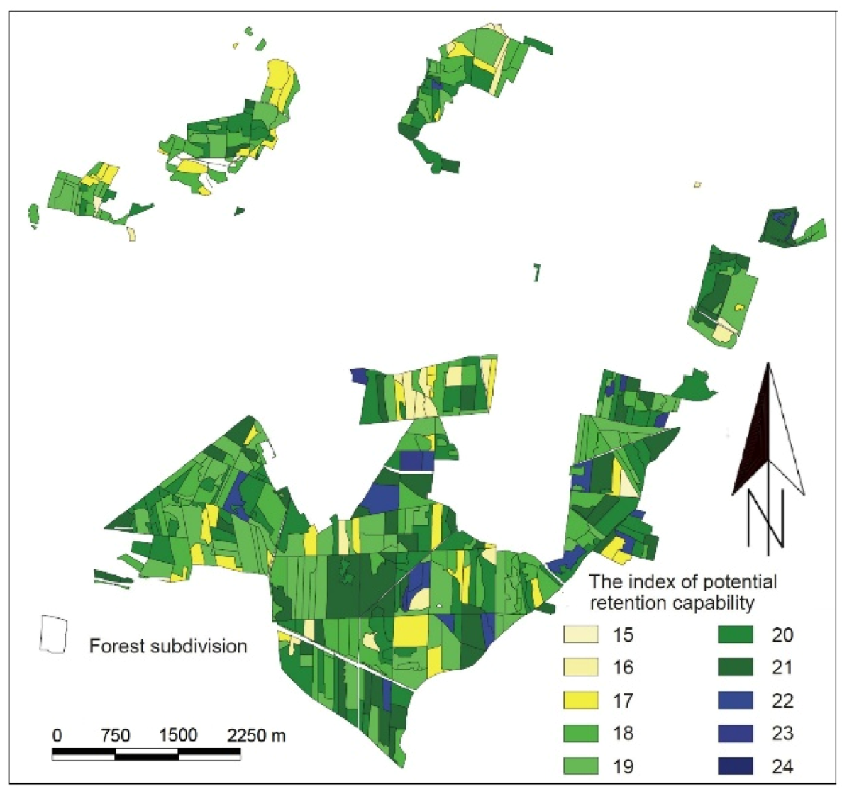
  68. Grajewski, S.; Krysztofiak, A.; Miler, A.T. Potencjalna zdolność retencyjna obszarów leśnych na przykładzie Leśnictwa Doświadczalnego Unieszów. J. Water Land Dev. 2009, 13, 71–84. [Google Scholar]
  69. Wytyczne do Realizacji Małej Retencji w Górach: Przeciwdziałanie Skutkom Odpływu Wód Opadowych na Terenach Górskich. Zwiększenie Retencji i Utrzymanie Potoków oraz Związanej z Nimi Infrastruktury w Dobrym Stanie. Podręcznik Wdrażania Projektu; Projekt Lasów Państwowych z listy indykatywnej POIiŚ 3.1-5; Część I: Warsaw, Poland, 2010.
  70. Miler, A. Modelowanie Matematyczne Zdolności Retencyjnych Małych Zlewni Nizinnych; Rozp. Nauk., 258; Rocz. AR: Poznań, Poland, 1994. [Google Scholar]
  71. Miler, A. Modelowanie Obszarowych Zmienności Różnych Miar Retencji; Wyd. AR: Poznań, Poland, 1998. [Google Scholar]
  72. Miler, A.T.; Grajewski, S.; Okoński, B. Stosunki Wodne w Wybranych Ekosystemach Puszczy Zielonka; Wyd. AR: Poznań, Poland, 2001. [Google Scholar]
  73. Miler, A.T.; Krysztofiak, A. Potencjalne zdolności retencyjne Wielkopolskiego Parku Narodowego. Infrastrukt. Ekol. Teren. Wiej. 2006, 3, 45–55. [Google Scholar]
  74. Bykowski, J.; Przybyła, C.; Napierała, M.; Mrozik, K.; Pęciak, A. Ocena stanu technicznego infrastruktury wodno-melioracyjnej na Polderze Zagórów. Inż. Ekolog. 2014, 39, 42–50. [Google Scholar]
  75. Łańduch, A. Przyroda wzięła odwet. Przegląd Pożarniczy 2012, 9, 8. [Google Scholar]
  76. Instrukcja Ochrony Przeciwpożarowej Obszarów Leśnych 1996; Dyrekcja Generalna Lasów Państwowych: Warsaw, Poland, 1996.
  77. Instrukcja Ochrony Przeciwpożarowej Obszarów Leśnych 2020; Dyrekcja Generalna Lasów Państwowych: Warsaw, Poland, 2020.
  78. Haze, M. (Ed.) Instrukcja Ochrony Przeciwpożarowej Lasu; Załącznik do Zarządzenia nr 54 Dyr. Generalnego Lasów Państwowych z 21 listopada 2011 r. OB. 1.01. 2012; CILP: Warsaw, Poland, 2011. [Google Scholar]
  79. Rozporządzenie Ministra Środowiska z dnia 22 marca 2006 r. w sprawie szczegółowych zasad zabezpieczenia przeciwpożarowego lasów; Dz. U. z 2006 r. nr 58 poz. 405; Rządowe Centrum Legislacji: Warsaw, Poland, 2006.
  80. Rozporządzenie Ministra Środowiska z dnia 13 lipca 2015 r. zmieniające rozporządzenie w sprawie szczegółowych zasad zabezpieczenia przeciwpożarowego lasów; Dz. U. z 2015 r. nr 0 poz. 1070; Rządowe Centrum Legislacji: Warsaw, Poland, 2006.
  81. Czerniak, A.; Gornowicz, R.; Miler, A.T.; Trzciński, G.; Grajewski, S.M.; Kapuścińska, J. Planowanie sieci Dróg Leśnych i Składnic oraz Optymalizacja Wskaźników Gęstości Dróg Leśnych dla Różnych Terenów Polski; Sprawozdanie końcowe z realizacji tematu zleconego przez Dyrekcję Generalną Lasów Państwowych w Warszawie; Maszynopis Katedra Inżynierii Leśnej UPP: Poznań, Poland, 2016. [Google Scholar]
  82. Trzciński, G.; Czerniak, A. Stan techniczny dróg leśnych—Potrzeby remontowe. Sylwan 2017, 161, 539–547. [Google Scholar]
  83. Grajewski, S.M. Funkcjonalność Leśnych Dojazdów Pożarowych Względem Wymogów Współczesnych Pojazdów Ratowniczo-Gaśniczych oraz Aktualnie Stosowanych Taktyk i Technologii Gaszenia Pożarów Lasów; Rozprawy Naukowe 511; Wyd. UP w Poznaniu: Poznań, Poland, 2019. [Google Scholar]
  84. Grajewski, S.M.; Czerniak, A.; Szóstakowski, P. Features and performance of forest fire access roads and fire department connections as assessed by employees of the Polish State Fire Service. Saf. Fire Technol. 2019, 53, 68–87. [Google Scholar] [CrossRef]
  85. Grajewski, S.M.; Czerniak, A. Wykorzystanie lekkiej płyty dynamicznej do kontroli robót drogowych prowadzonych w lasach. Przegląd Leśniczy 2015, 10, 10–11. [Google Scholar]
  86. Grajewski, S.M. Wieloletnia zmienność pożarów lasu w wybranych 28 krajach Europy Kanadzie i USA. BiTP 2017, 3, 46–58. [Google Scholar]
  87. Grajewski, S.M. Effectiveness of forest fire security systems in Poland. Infrastrukt. Ekol. Teren. Wiej. 2017, 4, 1563–1576. [Google Scholar]
  88. Livneh, M.; Goldberg, Y. Quality assessment during road formation and foundation construction: Use of falling-weight deflectometer and light drop weight. J. Transp. Res. Board 2001, 1755, 69–77. [Google Scholar] [CrossRef]
  89. Czerniak, A. Powierzchniowe i wgłębne wzmacnianie gruntów. Zesz. Nauk. Ar We Wrocławiu 2001, 419, 47–62. [Google Scholar]
  90. Czerniak, A. Wpływ mikrozbrojenia rozproszonego na wytrzymałość na ściskanie cementogruntów stosowanych w leśnym budownictwie drogowym. In Kształtowanie i Ochrona Środowiska Leśnego; Miler, A.T., Ed.; AR w Poznaniu: Poznań, Poland, 2001; pp. 450–460. [Google Scholar]
  91. Czerniak, A.; Kamiński, B. Przydatność geokraty do budowy dróg leśnych. PTPN Wydz. Nauk Roln. Leśn. Prace Kom. Nauk Roln. Kom. Nauk Leśn. 2003, 94, 39–48. [Google Scholar]
  92. Kamiński, B. Stabilizacja piasku średniego popiołem lotnym i cementem. In Kształtowanie i Ochrona Środowiska Leśnego; Miler, A.T., Ed.; AR w Poznaniu: Poznań, Poland, 2003; pp. 469–477. [Google Scholar]
  93. Kamiński, B. Przydatność żużla i stłuczki szklanej do stabilizacji granulometrycznej leśnych dróg gruntowych. PTPN Wydz. Nauk Roln. Leśn. Prace Kom. Nauk Roln. Kom. Nauk Leśn. 2004, 96, 103–110. [Google Scholar]
  94. Kamiński, B. Ocena przydatności geosyntetyków stosowanych w budownictwie dróg leśnych. Zarządzanie Ochroną Przyrody w Lasach 2007, 1, 173–177. [Google Scholar]
  95. Czerniak, A. Wybrane cechy fizyczne i mechaniczne cementogruntu zbrojonego włóknami polipropylenowymi. In Użytkowanie Lasu a Trwały i Zrównoważony Rozwój Leśnictwa; Giefing, D.F., Bembenek, M., Eds.; Akademia Rolnicza im. Augusta Cieszkowskiego: Poznań, Poland, 2005; pp. 113–118. [Google Scholar]
  96. Kamiński, B. Popioły i Mieszanki Popiołowo-Żużlowe w Aspekcie Bezpiecznego Utrwalania Nawierzchni Dróg Leśnych na Podłożach Spoistych; Rozpr. Nauk. AR w Poznaniu 320; AR w Poznaniu: Poznań, Poland, 2001. [Google Scholar]
  97. Czerniak, A. Zanieczyszczenie i Bioindykacja Stref Ekotonowych Lasu Mieszanego Świeżego (LMśw) w Zasięgu Oddziaływania Cementowo-Gruntowych Podbudów Drogowych; Rozpr. Nauk. 357; AR w Poznaniu: Poznań, Poland, 2004. [Google Scholar]
  98. Miler, A.T.; Kamiński, B.; Czerniak, A.; Grajewski, S.; Okoński, B.; Stasik, R.; Drobiewska, E.; Krysztofiak, A.; Poszyler-Adamska, A.; Korżak, M. Ochrona Obszarów Mokradłowych na Terenach Leśnych; Uniwersytet Przyrodniczy w Poznaniu: Poznań, Poland, 2008. [Google Scholar]
  99. Grajewski, S.M.; Czerniak, A.; Kayzer, D.; Kasztelan, A. Application of a geotextile and geotextile semi-mattress to reinforce a low-bearing capacity subgrade of a forest technological route on a swampy terrain. Infrastruct. Ecol. Rural Areas 2015, 4, 1387–1397. [Google Scholar] [CrossRef]
  100. Trzciński, G.; Czerniak, A.; Grajewski, S. Funkcjonowanie infrastruktury komunikacyjnej obszarów leśnych. Infrastrukt. Ekol. Teren. Wiej. 2016, 2, 527–542. [Google Scholar] [CrossRef]
  101. Czerniak, A.; Grajewski, S.; Kamiński, B.; Miler, A.T.; Okoński, B.; Leciejewski, P.; Trzciński, G.; Madaj, A.; Bańkowski, J.; Wojtkowski, K. Wytyczne Prowadzenia Robót Drogowych w Lasach; PGL LP OR-W LP w Bedoniu: Warsaw/Bedoń, Poland, 2013. [Google Scholar]
  102. Czerniak, A.; Grajewski, S.M. Badanie nośności dróg—Gwarancją solidności realizacji inwestycji. Przegląd Leśniczy 2014, 4, 10–12. [Google Scholar]
  103. Grajewski, S.; Czerniak, A. Znaczenie wilgotności gruntu i kruszywa w procesie zagęszczania podłoża drogowego i warstw konstrukcji nawierzchni dróg leśnych. Przegląd Leśniczy 2015, 11, 14–15. [Google Scholar]
  104. Raport o Stanie Lasów w Polsce 2018 and 2019; PGL LP CILP: Warsaw, Poland, 2019.
  105. Lasy Państwowe w Liczbach 2018/The State Forests in Figures; PGL LP CILP: Warsaw, Poland, 2018.
  106. Gössling, S.; Hickler, T. Tourism and forest ecosystems. In Tourism and Global Environmental Change: Ecological Social Economic and Political Interrelationships; Gössling, S., Hickler, T., Eds.; Routledge: London, UK; Taylor & Francis Group: New York, NY, USA, 2017; pp. 95–106. [Google Scholar]
  107. Czerniak, A.; Migoń, P.; Jaszczak, R.; Latocha, A.; Królikowska, K.; Kurowska, E.; Pijet-Migoń, E.; Rogowski, M.; Bańkowski, J.; Basa, K.; et al. Strategia Rozwoju Turystyki w Górach Stołowych; PNGS: Kudowa-Zdrój, Poland, 2019. [Google Scholar]
  108. European Forest Ecosystems state and Trends; Publications Office of the European Union: Luxembourg, 2016.
  109. Liang, J.; Crowther, T.W.; Picard, N.; Wiser, S.; Zhou, M.; Alberti, G.; Schulze, E.-D.; McGuire, A.D.; Bozzato, F.; Pretzsch, H.; et al. Positive biodiversity-productivity relationship predominant in global forests. Science 2016, 6309, aaf8957. [Google Scholar] [CrossRef] [Green Version]
  110. Tyburski, Ł.; Czerniak, A. Koszty zdarzeń drogowych z udziałem zwierzyny. Studia i Materiały CEPL w Rogowie 2013, 15, 48–56. [Google Scholar]
  111. Czerniak, A.; Tyburski, Ł.; Górna, M.; Fierkowicz, K.; Łabędzki, A.; Beker, C. Why do we build wildlife crossing in Poland? In Materiały konferencyjne: Klimat, Ekologia, Rolnictwo Euroazji 2015; Państwowy Uniwersytet Rolniczy: Irkuck, Poland, 2015. [Google Scholar]
  112. Czerniak, A.; Górna, M. Funkcjonalność Przejść Górnych dla Zwierząt; Bogucki Wydawnictwo Naukowe: Poznań, Poland, 2010. [Google Scholar]
  113. Czerniak, A.; Tyburski, Ł. Zdarzenia Drogowe z Udziałem Zwierzyny na Drogach Publicznych; Bogucki Wydawnictwo Naukowe: Poznań, Poland, 2014. [Google Scholar]
  114. Available online: http://www.neel.com.pl/web/?id=1,5 (accessed on 20 May 2020).
  115. Available online: http://www.wielkopolskipn.pl/index.php/park/kategoria/pl/wpn-/84 (accessed on 8 February 2020).
  116. Walczykowski, P.; Orych, A.; Łysenko, J. A case study of using Landsat TM imagery to determine the risk of forest fire. Arch. Fotogram. Kartogr. Teledetekcji 2012, 24, 393–402. [Google Scholar]
  117. Yao, H.; Qin, R.; Chen, X. Unmanned Aerial Vehicle for Remote Sensing Applications—A Review. Remote Sens. 2019, 11, 1443. [Google Scholar] [CrossRef] [Green Version]
  118. Carvaja-Ramírez, F.; Silva, J.R.M.; Agüera-Vega, F.; Martínez-Carricondo, P.; Serrano, J.; Moral, F.J. Evaluation of Fire Severity Indices Based on Pre- and Post-Fire Multispectral Imagery Sensed from UAV. Remote Sens. 2019, 11, 993. [Google Scholar] [CrossRef] [Green Version]
  119. Shin, J.; Seo, W.; Kim, T.; Park, J.; Woo, C. Using UAV multispectral images for classification of forest burn severity—A case study of the 2019 Gangneung forest fire. Forests 2019, 10, 1025. [Google Scholar] [CrossRef] [Green Version]
  120. Borkowski, R.; Duńska, K.; Leśniak, H.; Strzeliński, P. A comparison of mapping results of forest areas other than subcompartments in the forest inventory using unmanned aerial vehicles. Acta Sci. Pol. Silv. 2019, 18, 4. [Google Scholar]
  121. Hernández-Clemente, R.; Hornero, A.; Mottus, M.; Penuelas, J.; González-Dugo, V.; Jiménez, J.C.; Suárez, L.; Alonso, L.; Zarco-Tejada, P.J. Early diagnosis of vegetation health from high-resolution hyperspectral and thermal imagery: Lessons learned from empirical relationships and radiative transfer modeling. Curr. For. Rep. 2019, 5, 169–183. [Google Scholar] [CrossRef] [Green Version]
  122. Węgiel, A.; Ociepka, S.; Błasiak, A. Use of Terrestrial Laser Scanner to Determine Volume of Trees Growing Under Canopy. Acta Sci. Pol. Silv. Colendar. Ratio Ind. Lignar 2018, 17, 267–274. [Google Scholar] [CrossRef]
  123. Pneque-Gálvez, J.; McCall, M.K.; Napoletano, B.M.; Wich, S.A.; Koh, L.P. Small drones for community-based forest monitoring: An assesment of their feasibility and potential in tropical areas. Forests 2014, 5, 1481–1507. [Google Scholar] [CrossRef] [Green Version]
Figure 1. Map of Poland with locations of research areas mentioned in the paper: 1—Faculty of Forestry, Poznań University of Life Sciences; 2—Karnieszewice Forest District; 3—Jarocin Forest District and “Uroczysko Warta” floodplain forest; 4—Lipka Forest District; 5—Experimental Forest Unieszów; 6—Tatra Mountains National Park; 7—Karkonosze Mountains National Park; 8—Promotion Forest Complex of the Barycz River Valley; 9—Table Mountains National Park and Kłodzko Province; 10—Śnieżka Forest District; 11—Greater Poland National Park; 12—Wipsowo Forest District; 13—Noteć Forest; 14—Jeziorsko reservoir; 15—Rudy Raciborskie Forest District; 16—Biebrza National Park.
Forests 11 00614 g001
Figure 2. Rainfall distribution in Poland: annual precipitations for period 2011–2018 and the average rainfall for the decade 2001–2010 (data collected from 34 synoptic stations located throughout Poland); the numbers on the x axis represent the following stations: 1–4: Baltic Sea coastal region, 5–19: Polish Lowlands (a zone of lowlands in North and Central Poland), 20–27: Polish Highlands; 28–32: mountain areas (compiled on the basis of data published by the Central Statistical Office in the years 2001–2019 [1]).
Forests 11 00614 g002
Figure 3. A damming step, the Karnieszewice Forest District (Photo: A. Krysztofiak-Kaniewska).
Forests 11 00614 g003
Figure 4. An overspill with a backflow preventer, the “Uroczysko Warta” in the Jarocin Forest District (Photo: A. Krysztofiak-Kaniewska).
Forests 11 00614 g004
Figure 5. Wetlands—small retention provided by beaver dams, the Lipka Forest District (Photo: A. Krysztofiak-Kaniewska).
Forests 11 00614 g005
Figure 6. Potential retention capacity of forest areas based on the Unieszów Experimental Forest [68].
Forests 11 00614 g006
Figure 7. Assessment of potential fire hazard in Polish forests according to forest district (I, II, III—categories of forest fire hazard, as of 31 December 2018).
Forests 11 00614 g007
Figure 8. Statistical characteristics of constrained modulus during secondary compression (E2) according to groups of surfaces in fire roads (GNN: ungraded dirt road; GNP: graded dirt road; GU: improved dirt road surface; Po/Ż: gravelly sand or gravel surfaces; Żuż: slag surfaces (blast furnace slag); Rec: surfaces of recycled aggregates (concrete debris, construction rubble, brick debris, rail subgrade crusher-run materials); Mopt: optimal dirt mix surfaces; Tłucz: crushed-stone aggregate road surfaces; McA: macadam surfaces; T/GeoR: aggregate surfaces on geogrid; GeoK: geogrid surfaces; Emul: asphalt surfaced aggregate pavements; 1-war: single-layer surfaces; 2-war: 2-layer surfaces; 3-war: min. 3-layer surfaces; G1, G2, G3, G4: fire with G1, G2, G3 and G4 subgrades [83].
Forests 11 00614 g008
Figure 9. Estimation of the static constrained modulus during secondary compression (E2) based on values of dynamic constrained modulus (Evd) according to: (a) the original model of linear regression (proposed in [83]); (b) simplified conversion of Evd into E2 occasionally applied in practice; (c) the formula admissible in case of no data on other dependencies between Evd and E2 [88], in view of measurements of load-bearing capacity taken using a static plate on 109 different types of fire road surfaces [83].
Forests 11 00614 g009
Figure 10. A test of the geogrid’s suitability for separating aggregate from the subsoil. Effect: saving 20% of aggregate during construction of the forest fire roads (Photo: A. Czerniak).
Forests 11 00614 g010
Figure 11. Railway and road wildlife crossings in Poland (Photo: A. Czerniak).
Forests 11 00614 g011
Figure 12. Migration of boars, wolves and red deer using the wildlife overpass over national road no. 5 in the Greater Poland National Park (screenshots from the monitoring footage [115]).
Forests 11 00614 g012
Figure 13. Measurements of engineering objects on a forest road in the Śnieżka Forest District. The lower fragment of the orthophotomap: location of measurements with a VSS HMP PDG static plate, together with a counterweight and image of one of the open-top culverts in the audited road. The red lines point at a zoom-in on selected objects presented in the figure below (made by R. Borkowski).
Forests 11 00614 g013
Table 1. Results of studies on wildlife migrations recorded using a monitoring set in 2017.
2017 Red Deer Wild BoarRoe DeerFoxBadgerRaccoon DogMartenOthersTOTAL
StagHindCalfAdultYoungBuckDoeCalf
I541448303456498203811238422122573
II32228817536253941501256755151922
III72634610779849030192134105143132787
IV435394241734635100203932631946
V381881117717250270976421181088
VI23671327302110285512701671117
VII698747174204301605329148722
VIII2056429152113492792950227738
IX2677438427258273427403230251252
X23913062316217134641931100131181
XI5635572765562441112138711152372
XII160723812651830472000507
TOTAL41442555108942883434377274971248491325012618,205
Table 2. Results of studies on wildlife migrations recorded using a monitoring set in 2018.
2018 Red Deer Wild Boar Roe Deer FoxBadgerRaccoon DogMartenOthersTOTAL
StagHindCalfAdultYoungBuckDoeCalf
I26931915132318136400156751101498
II514396137147136824001452320151637
III330248722594241493401513806291740
IV42317452199477123130775413491645
V93658285416734079440915596
VI13315912812318180112290616760
VII617435267214417007327114131196
VIII100241139192380265416960123121478
IX28019884476842199243759074342316
X284369129453525214801692563272212
XI23334713935647924418019504282025
XII30553618337449198351315114022193
TOTAL302529821138320243262175258171452398524123019,296

