Intensified Management of Coffee Forest in Southwest Ethiopia Detected by Landsat Imagery


Abstract
1. Introduction
2. Materials and Methods
2.1. Ground Truth Fieldwork
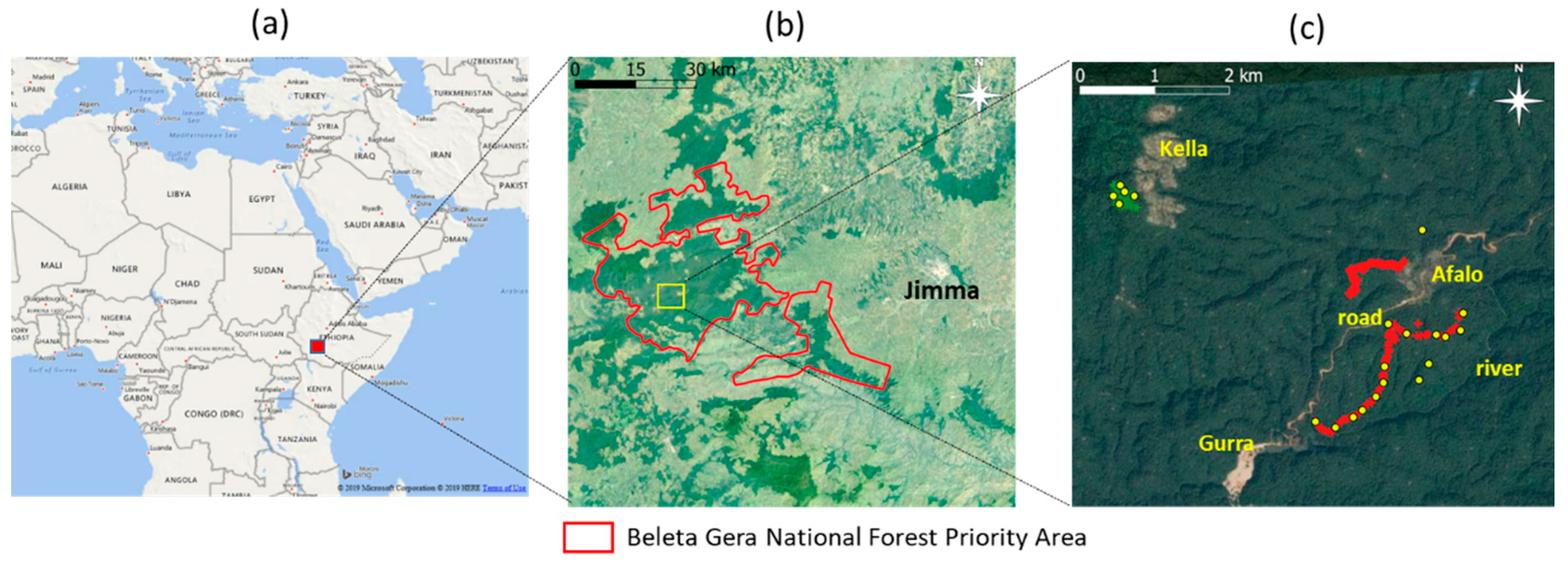
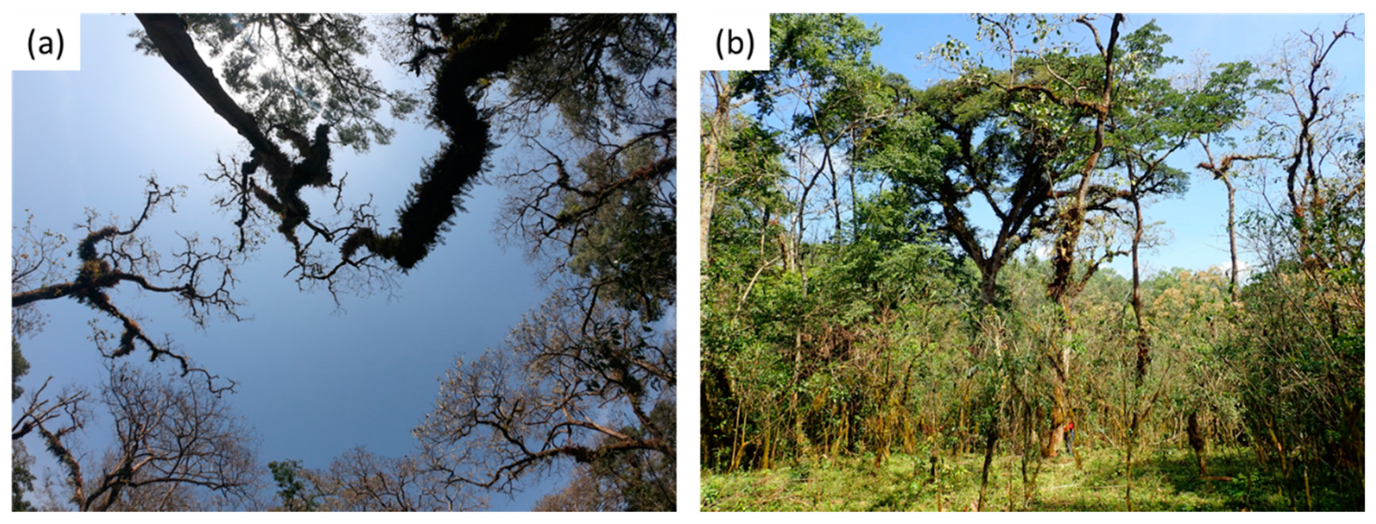
2.1.1. Study Area and Fieldwork Site
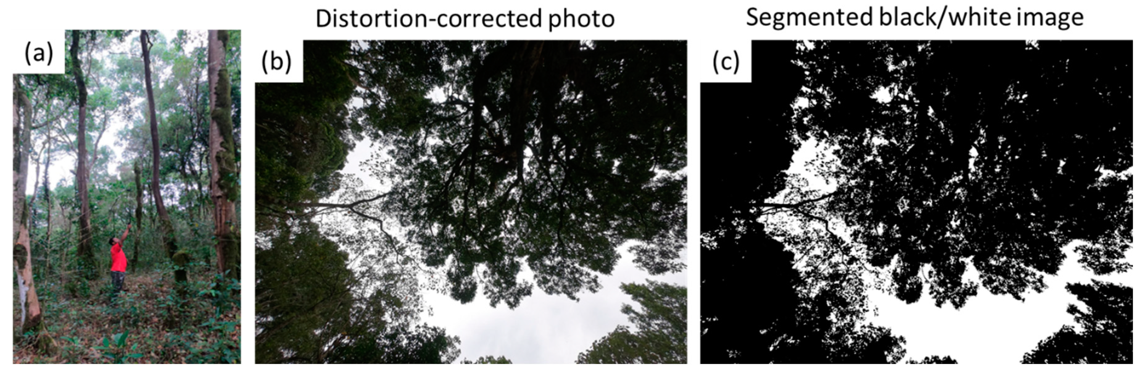
2.1.2. Canopy Cover Photography
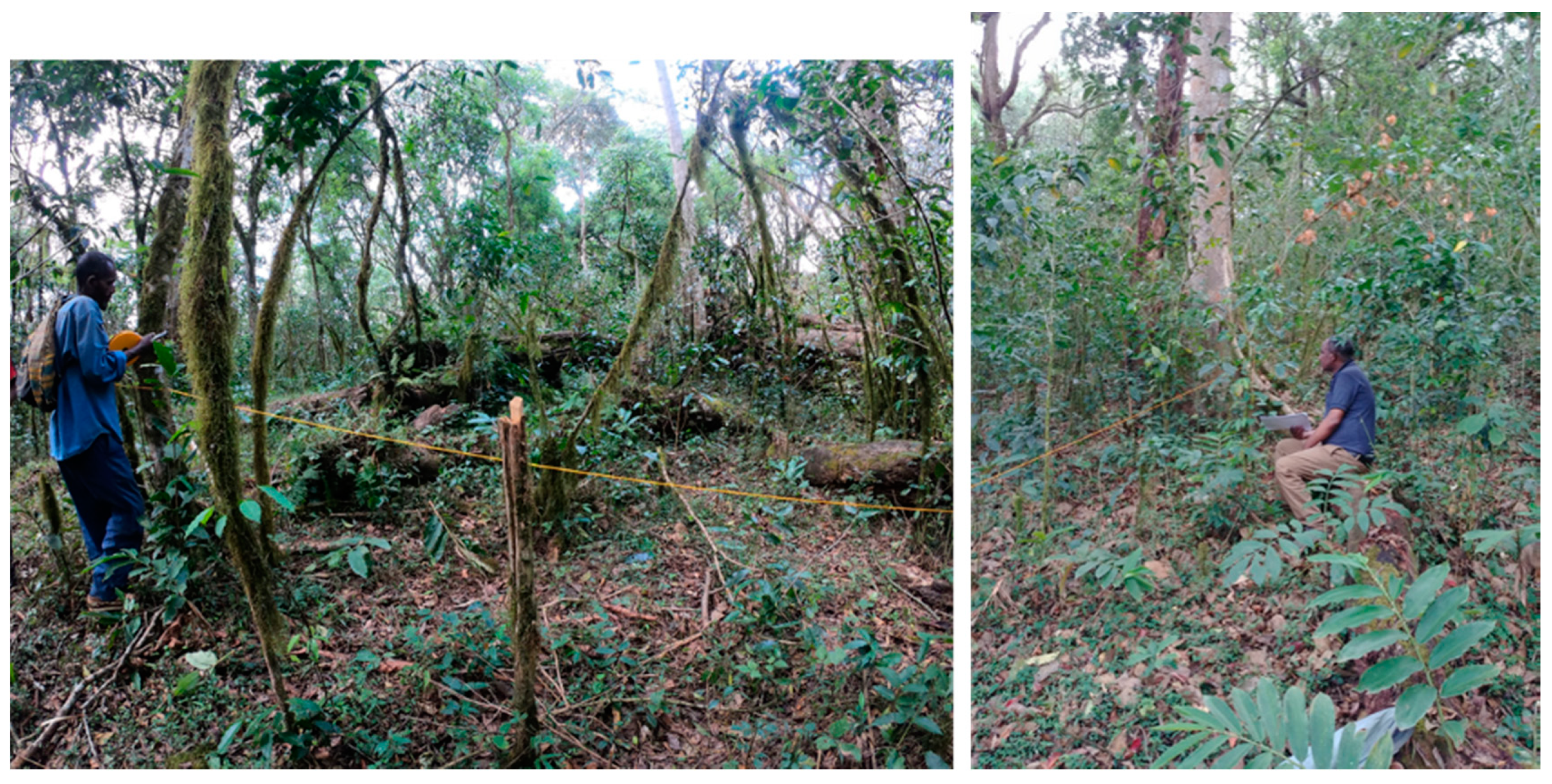
2.1.3. Tree Biodiversity Survey
2.2. Satellite Data and Processing
2.3. Constructing Mean Composite Maps
2.4. Tie-Point Approach
3. Results
3.1. Ground Truth Fieldwork Data
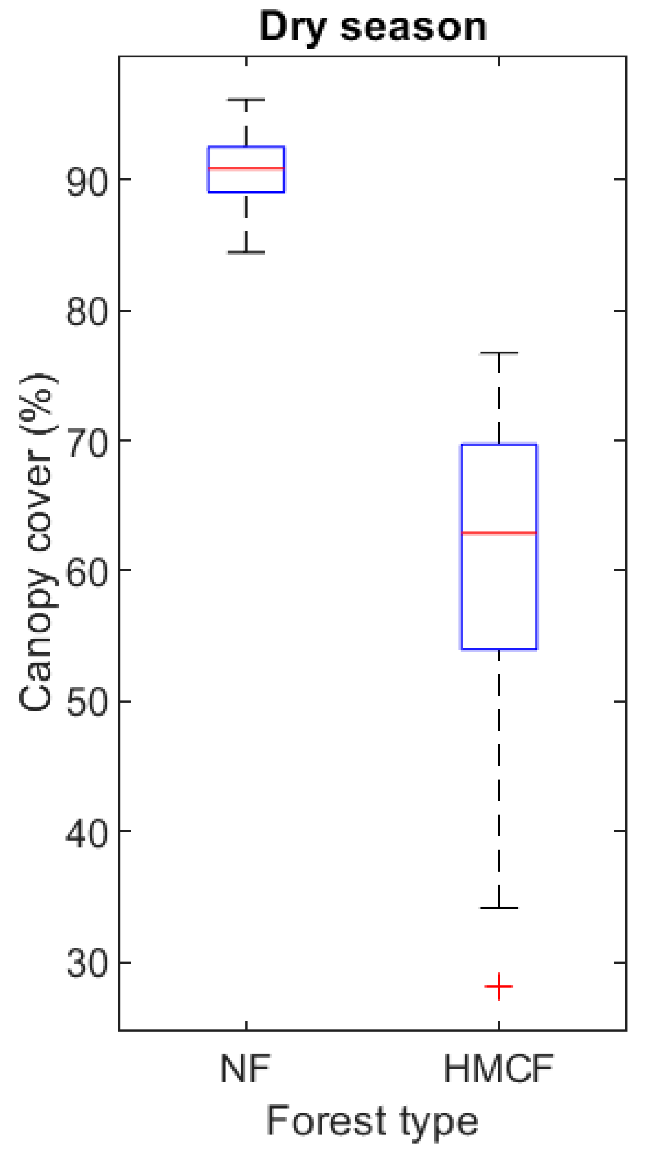
3.1.1. Canopy Cover Fraction
3.1.2. Tree Biodiversity Survey
3.2. Satellite Data Analysis for the 2019 Imagery
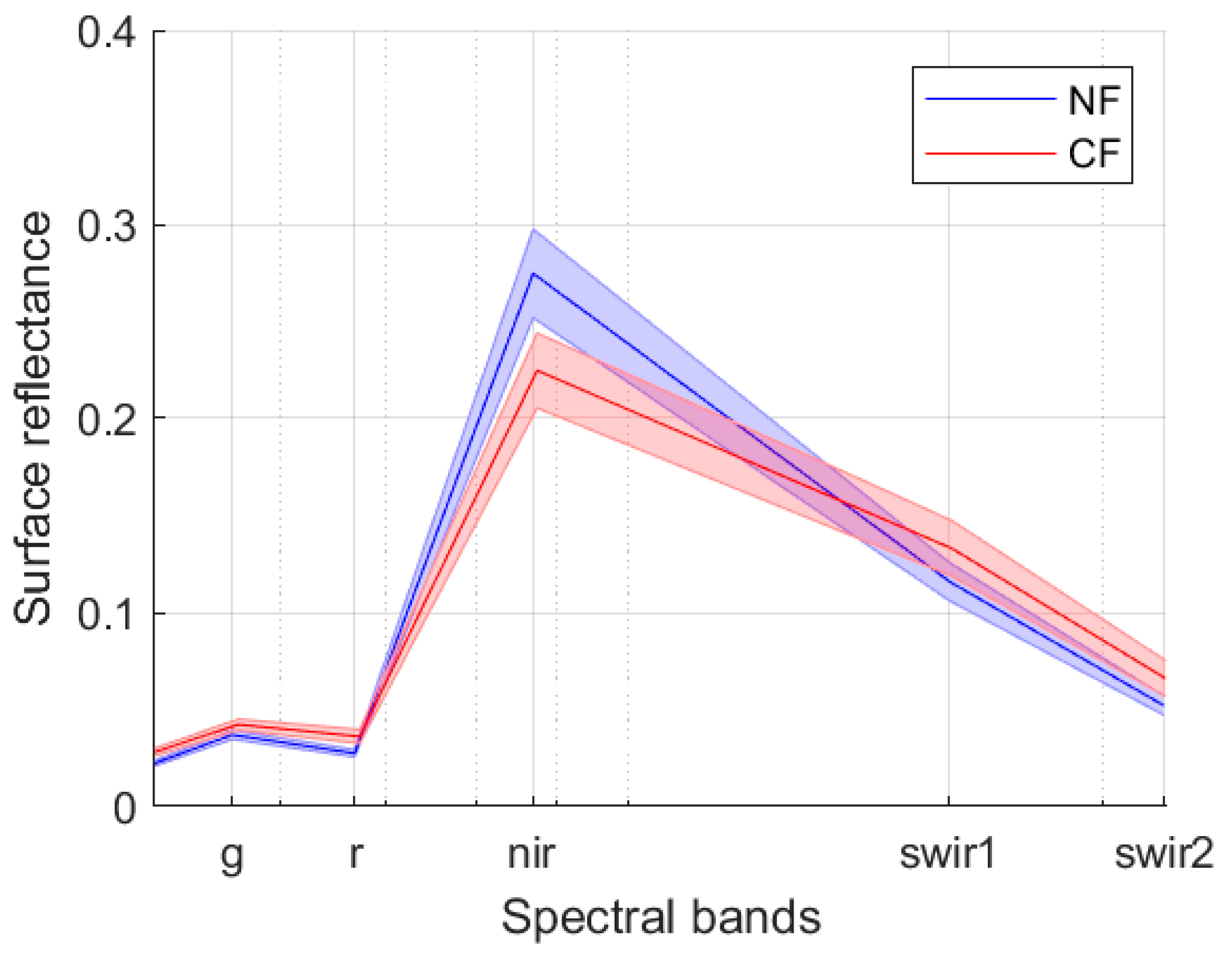
3.2.1. Spectral Characteristics
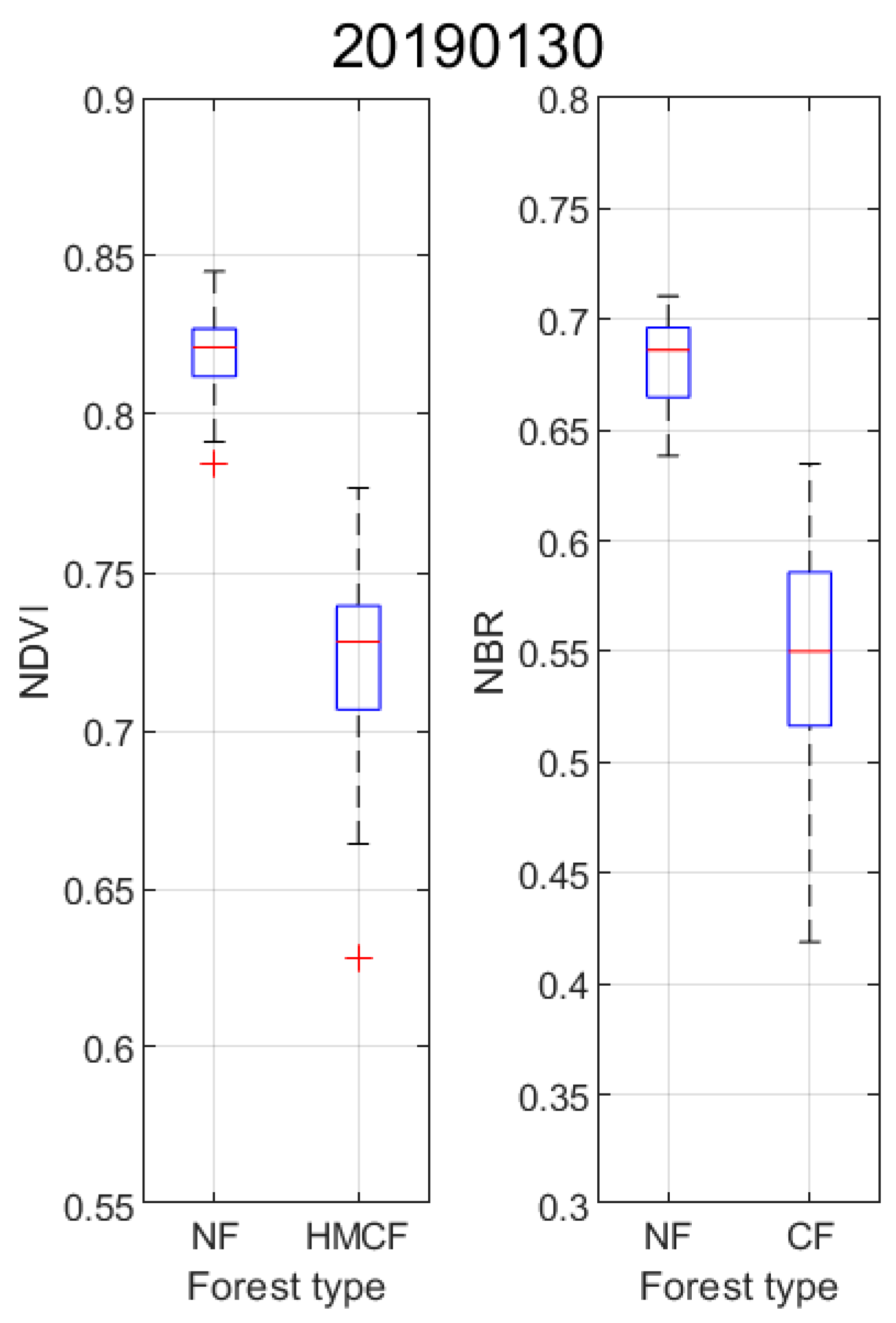
3.2.2. Vegetation Indices
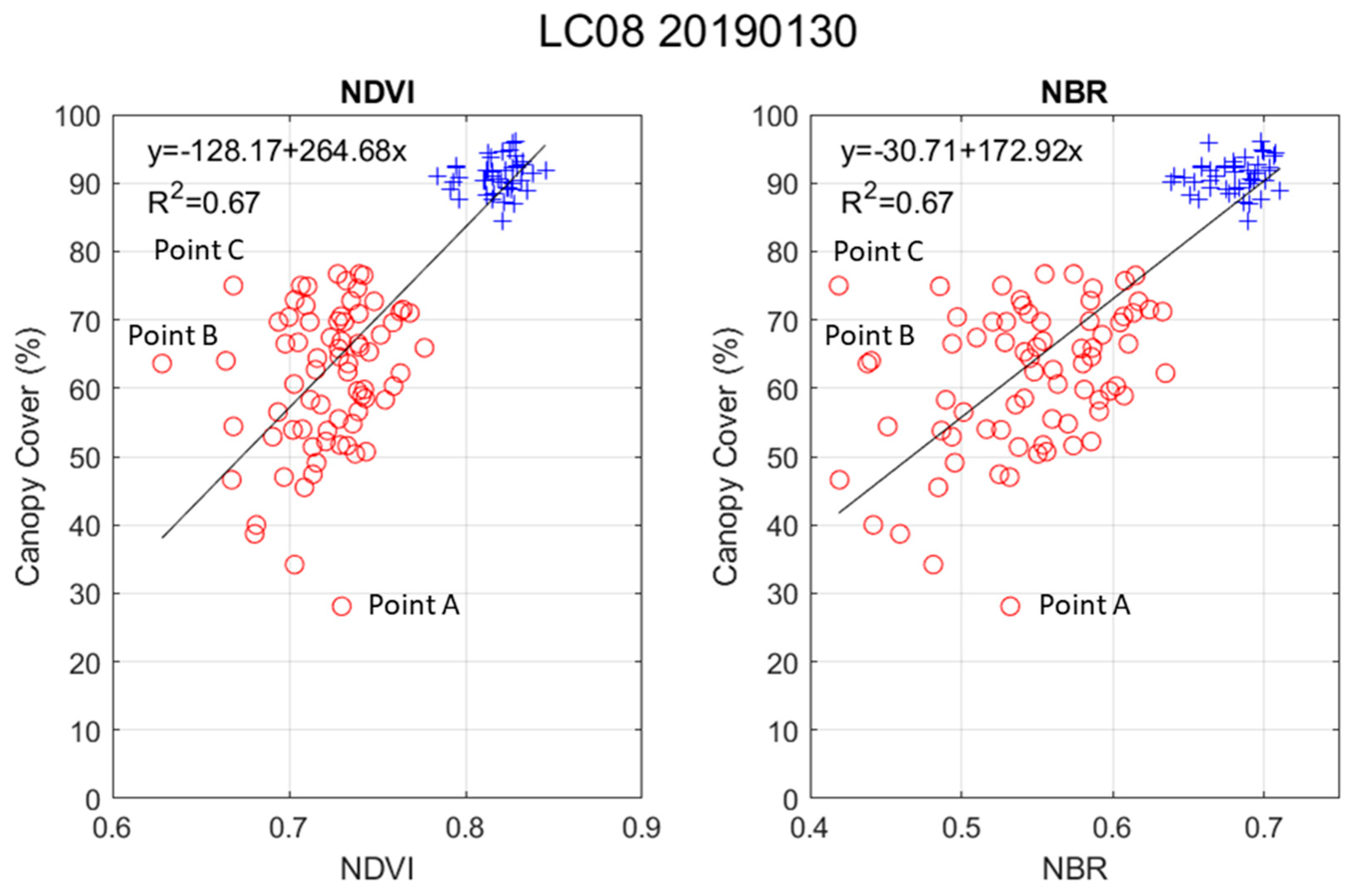
3.2.3. Comparison between Vegetation Indices and Canopy Cover
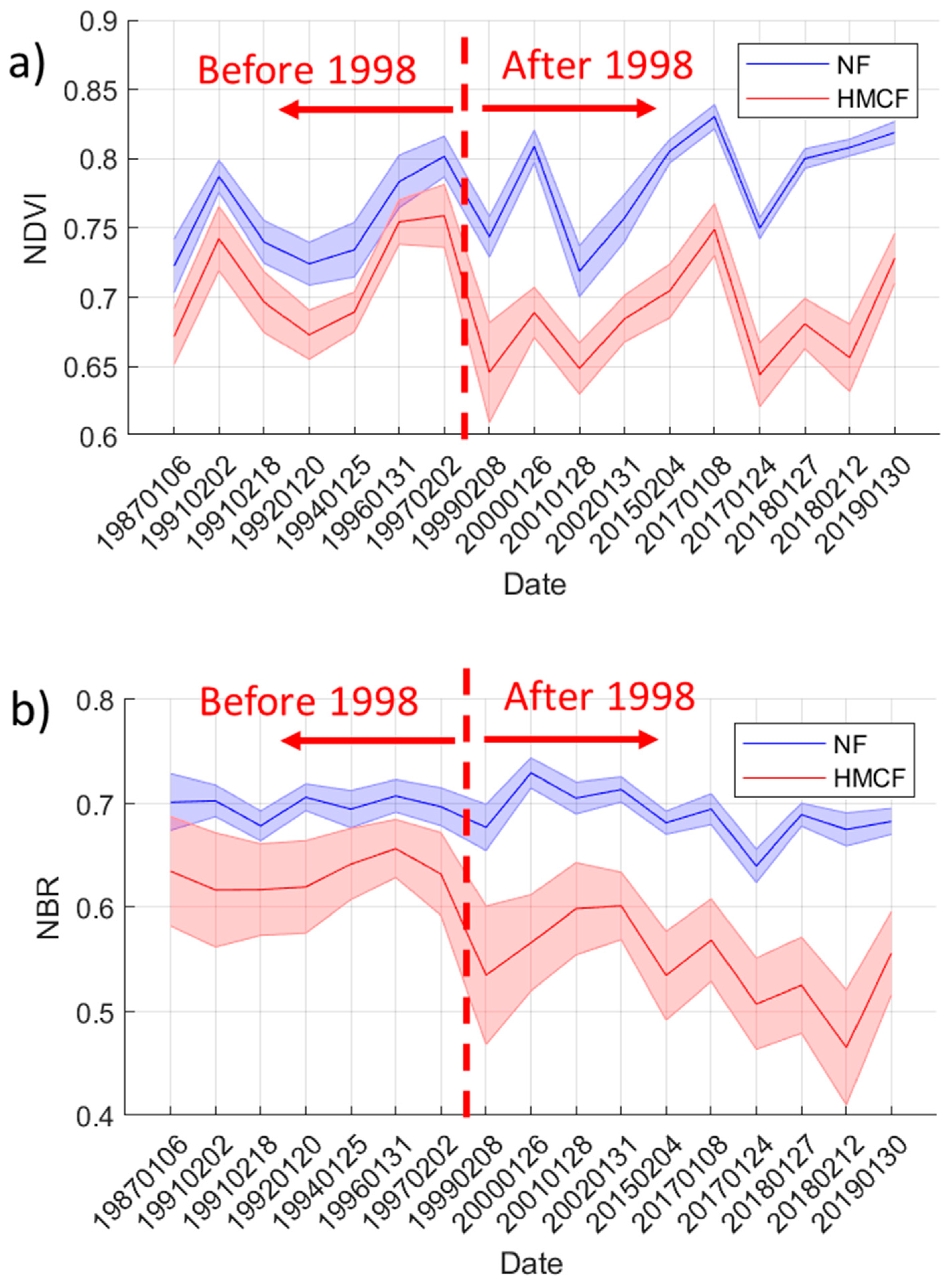
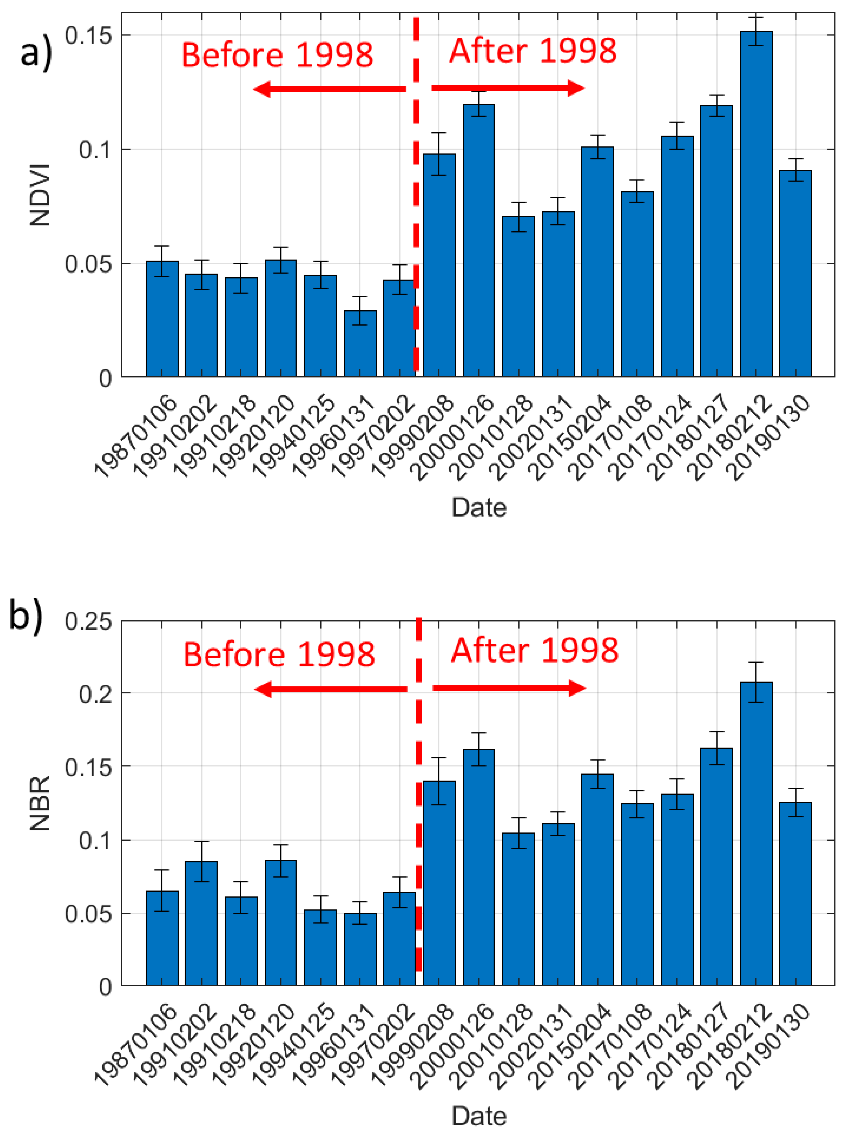
3.3. Temporal Evolution of NDVI and NBR between NF and HMCF
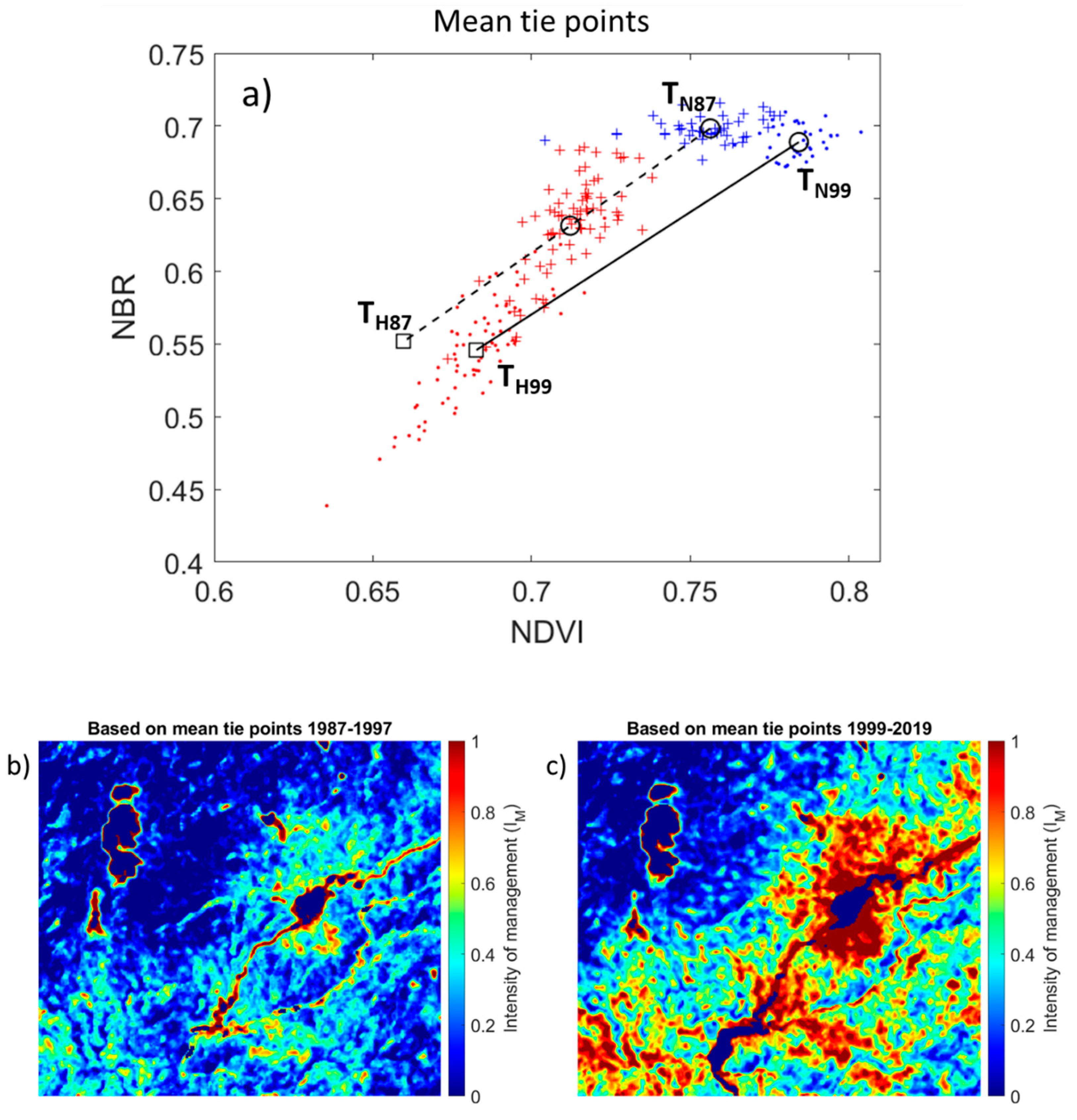
3.4. Estimating Degradation Caused by Intensive Management Practices Using the Tie-Point Method
3.4.1. Comparison of Mean State of NDVI and NBR between Two Periods (1987–1997 vs. 1999–2019)
3.4.2. Estimating the Intensity of Management Using Mean Tie-Points
3.4.3. Estimating the Intensity of Management Using Adjusted Tie-Points
4. Discussion
4.1. Can We Distinguish Heavily Managed Coffee Forest Areas from Undisturbed Natural Forest?
4.2. Can We Consistently Quantify the Level of Degradation Caused by Intensive Management in the Coffee Forest?
4.3. Understanding the Transition
5. Conclusions
Author Contributions
Funding
Acknowledgments
Conflicts of Interest
References
- EFAP. Ethiopian Forestry Action Program; EFAP: Addis Ababa, Ethiopia, 1994. [Google Scholar]
- Eshetu, Z.; Högberg, P. Reconstruction of forest site history in Ethiopian Highlands based on 13C natural abundance of soils. AMBIO A J. Hum. Environ. 2000, 29, 83–89. [Google Scholar] [CrossRef]
- Reusing, M. Change detection of natural high forest in Ethiopia, using remote sensing and GIS techniques. Int. Arch. Photogramm. Remote Sens. 2000, 23, 1254–1258. [Google Scholar]
- WBISPP (Woody Biomass Inventory and Strategic Planning Project). Manual for Woody Biomass Inventory; Ministry of Agriculture: Addis Ababa, Ethiopia, 2000.
- FAO (UN Forest and Agriculture Organization). Forest Resource Assessment (FRA) for Ethiopia; FAO: Rome, Italy, 2010; Available online: http://www.fao.org/docrep/013/al501E/al501e.pdf (accessed on 26 November 2019).
- Anthony, F.; Combes, M.-C.; Astorga, C.; Bertrand, B.; Graziosi, G.; Lashermes, P. The origin of cultivated Coffee arabica L. varieties revealed by AFLP and SSR markers. Theor. Appl. Genet. 2002, 104, 894–900. [Google Scholar] [CrossRef] [PubMed]
- Gole, T.W. Vegetation of the Yayu Forest in SW Ethiopia: Impacts of Human Use and Implications for In Situ Conservation of Wild Coffea arabica L. Populations; Ecology and Development Series No. 10; Centre for Development Research, University of Bonn: Bonn, Germany, 2003. [Google Scholar]
- Senbeta, F. Biodiversity and Ecology of Afromontane Rainforests with Wild Coffea arabica L. Populations in Ethiopia; Ecology and Development Series No. 38; Cuvillier: Göttingen, Germany, 2006. [Google Scholar]
- World Bank. Ethiopia—Trade and Transformation: Diagnostic Trade Integration Study: Summary and Recommendations (English); World Bank: Washington, DC, USA, 2004; Available online: http://documents.worldbank.org/curated/en/479381468252005382/Summary-and-recommendations (accessed on 26 November 2019).
- Foreign Agricultural Service (FAS). Global Agricultural Information Network. In Ethiopia—Coffee Annual Report; GAIN Report 1904; USDA Foreign Agricultural Service: Washington, DC, USA, 2019. Available online: https://www.fas.usda.gov/data/ethiopia-coffee-annual-4 (accessed on 4 December 2019).
- Aregay, M. The early history of Ethiopia’s coffee trade and the rise of Shawa. J. Afr. Hist. 1988, 29, 19–25. [Google Scholar] [CrossRef]
- Wood, A.; Tolera, M.; Snell, M.; O’Hara, P.; Hailu, A. Community forest management (CFM) in south-west Ethiopia: Maintaining forests, biodiversity and carbon stocks to support wild coffee conservation. Glob. Environ. Chang. 2019, 59. [Google Scholar] [CrossRef]
- Aerts, R.; Hundera, K.; Berecha, G.; Gijbels, P.; Baeten, M.; Van Mechelen, M.; Hermy, M.; Muys, B.; Honnay, O. Semi-forest coffee cultivation and the conservation of Ethiopian Afromontane rainforest fragments. For. Ecol. Manag. 2011, 261, 1034–1041. [Google Scholar] [CrossRef]
- Hundera, K.; Aerts, R.; Fontaine, A.; Van Mechelen, M.; Gijbels, P.; Honnay, O.; Muys, B. Effects of coffee management intensity on composition, structure and regeneration of Ethiopian moist evergreen afromontane forests. Environ. Manag. 2013, 51, 801–809. [Google Scholar] [CrossRef]
- Sutcliffe, J.P. Personal communication. 2015. [Google Scholar]
- Lambert, J.; Denux, J.-P.; Verbesselt, J.; Balent, G.; Cheret, V. Detecting clear-cuts and decreases in forest vitality using MODIS NDVI time series. Remote Sens. 2015, 7, 3588–3612. [Google Scholar] [CrossRef]
- Key, C.H.; Benson, N.C. Landscape assessment: Ground measure of severity, the composite burn index; and remote sensing of severity, the normalized burn ratio. In FIREMON: Fire Effects Monitoring and Inventory System; General Technical Report RMRS-GTR-164-CD; Rocky Mountain Research Station; USDA Forest Service: Ogden, UT, USA, 2006. [Google Scholar]
- Hermosilla, T.; Wulder, M.A.; White, J.C.; Coops, N.C.; Hobart, G.W. Regional detection, characterization, and attribution of annual forest change from 1984 to 2012 using Landsat-derived time-series metrics. Remote Sens. Environ. 2015, 170, 121–132. [Google Scholar] [CrossRef]
- Jarron, L.R.; Hermosilla, T.; Coops, N.C.; Wulder, M.A.; White, J.C.; Hobart, G.W.; Leckie, D.G. Differentiation of alternate harvesting practices using annual time series of Landsat data. Forests 2016, 8, 15. [Google Scholar] [CrossRef]
- Tortini, R.; Mayer, A.L.; Hermosilla, T.; Coops, N.C.; Wulder, M.A. Using annual Landsat imagery to identify harvesting over a range of intensities for non-industrial family forests. Landsc. Urban Plan. 2019, 188, 143–150. [Google Scholar] [CrossRef]
- Keeley, J.E. Fire intensity, fire severity and burn severity: A brief review and suggested usage. Int. J. Wildland Fire 2009, 18, 116–126. [Google Scholar] [CrossRef]
- Liu, S.; Wei, X.; Li, D.; Lu, D. Examining forest disturbance and recovery in the subtropical forest region of Zhejiang province using Landsat time-series data. Remote Sens. 2017, 9, 479. [Google Scholar] [CrossRef]
- Tucker, C.J. Red and photographic infrared linear combinations for monitoring vegetation. Remote Sens. Environ. 1979, 8, 127–150. [Google Scholar] [CrossRef]
- Glenn, E.P.; Huete, A.R.; Nagler, P.L.; Nelson, S.G. Relationship between remotely-sensed vegetation indices, canopy attributes and plant physiological processes: What vegetation indices can and cannot tell us about the landscape. Sensors 2008, 8, 2136–2160. [Google Scholar] [CrossRef]
- Pettorelli, N.; Vik, J.O.; Mysterud, A.; Gaillard, J.M.; Tucker, C.J.; Stenseth, N.C. Using the satellite-derived NDVI to assess ecological responses to environmental change. Trends Ecol. Evol. 2005, 20, 503–510. [Google Scholar] [CrossRef]
- Sothe, C.; de Almeida, C.M.; Liesenberg, V.; Schimalski, M.B. Evaluating Sentinel-2 and Landsat-8 data to map sucessional forest stages in a subtropical forest in Southern Brazil. Remote Sens. 2017, 9, 838. [Google Scholar] [CrossRef]
- Moat, J.; Williams, J.; Baena, S.; Wilkinson, T. Resilience potential of the Ethiopian coffee sector under climate change. Nat. Plants 2017, 3, 17081. [Google Scholar] [CrossRef]
- Salah, M.B.; Mitiche, A.; Ayed, I.B. Multiregion image segmentation by parametric kernel graph cuts. IEEE Trans Image Process. 2011, 20, 545–557. [Google Scholar] [CrossRef]
- Hwang, B.; Ren, J.; McCormack, S.; Berry, C.; Ben Ayed, I.; Graber, H.C.; Aptoula, E. A practical algorithm for the retrieval of floe size distribution of Arctic sea ice from high-resolution satellite synthetic aperture radar imagery. Elem. Sci. Anth. 2017, 5, 38. [Google Scholar] [CrossRef]
- Kent, M.; Coker, P. Vegetation Description and Analysis: A Practical Approach; John Wiley and Sons, Inc.: Hoboken, NJ, USA, 1992. [Google Scholar]
- Flood, N. Counituity of reflectance data between Landsat-7 ETM+ and Landsat-8 OLI, for both top-of-atmosphere and surface reflectance: A study in the Australian landscape. Remote Sens. 2014, 6, 7952–7970. [Google Scholar] [CrossRef]
- Asner, G.P.; Lobell, D.B. A biogeophysical approach for automated SWIR unmixing of soils and vegetation. Remote Sens. Environ. 2000, 75, 99–122. [Google Scholar] [CrossRef]
- Cavalieri, D.J.; Gloersen, P.; Campbell, W.J. Determination of sea ice parameters with the Nimbus 7 SMMR. J. Geophys. Res. 1984, 89, 5355–5369. [Google Scholar] [CrossRef]
- Comiso, J.C.; Cavalieri, D.J.; Parkinson, C.L.; Gloersen, P. Passive microwave algorithms for sea ice concentration: A comparison of two techniques. Remote Sens. Environ. 1997, 60, 357–384. [Google Scholar] [CrossRef]
- Liu, H.Q.; Huete, A.R. A feedback based modification of the NDV I to minimize canopy background and atmospheric noise. IEEE Trans. Geosci. Remote Sens. 1995, 33, 457–465. [Google Scholar] [CrossRef]
- Ayana, A.; Arts, B.; Wiersum, K.F. Historical development of forest policy in Ethiopia: Trends of institutionalization and deinstitutionalization. Land Use Policy 2013, 32, 186–196. [Google Scholar] [CrossRef]
- Macrotrends. Available online: https://www.macrotrends.net/2535/coffee-prices-historical-chart-data (accessed on 20 January 2020).


| Date | Activity | Season |
|---|---|---|
| 19 February 2019 | Canopy photos and tree surveys at NF | Dry Dry |
| 21–25 February 2019 | Canopy photos and tree surveys at HMCF |
| Satellite Sensor and Data Product | Acquisition Date (yyyymmdd) | Comments |
|---|---|---|
| Lansat-5/TM Level 2 Surface Reflectance | 19870106 19910202 19910218 19920120 19940125 19960131 19970202 19990208 20000126 20010128 20020131 | Used for time-series analysis |
| Landsat-8/OLI Level 2 Surface Reflectance | 20150204 20170108 20170124 20180127 20180212 | |
| 20190130 | Used for comparison with field data |
| Forest Type | Number of Species | Number of Trees | Basal Area (m2/ha) |
|---|---|---|---|
| NF | 7.4 ± 0.5 | 35.8 ± 13.7 | 135 |
| HMCF | 6.8 ± 2.2 | 14.8 ± 7.7 | 58 |
© 2020 by the authors. Licensee MDPI, Basel, Switzerland. This article is an open access article distributed under the terms and conditions of the Creative Commons Attribution (CC BY) license (http://creativecommons.org/licenses/by/4.0/).
Share and Cite
Hwang, B.; Hundera, K.; Mekuria, B.; Wood, A.; Asfaw, A. Intensified Management of Coffee Forest in Southwest Ethiopia Detected by Landsat Imagery. Forests 2020, 11, 422. https://doi.org/10.3390/f11040422
Hwang B, Hundera K, Mekuria B, Wood A, Asfaw A. Intensified Management of Coffee Forest in Southwest Ethiopia Detected by Landsat Imagery. Forests. 2020; 11(4):422. https://doi.org/10.3390/f11040422
Chicago/Turabian StyleHwang, Byongjun, Kitessa Hundera, Bizuneh Mekuria, Adrian Wood, and Andinet Asfaw. 2020. "Intensified Management of Coffee Forest in Southwest Ethiopia Detected by Landsat Imagery" Forests 11, no. 4: 422. https://doi.org/10.3390/f11040422
APA StyleHwang, B., Hundera, K., Mekuria, B., Wood, A., & Asfaw, A. (2020). Intensified Management of Coffee Forest in Southwest Ethiopia Detected by Landsat Imagery. Forests, 11(4), 422. https://doi.org/10.3390/f11040422