Spatial Perception of Urban Forests by Citizens Based on Semantic Differences and Cognitive Maps

Abstract
:1. Introduction
2. Materials and Survey Design
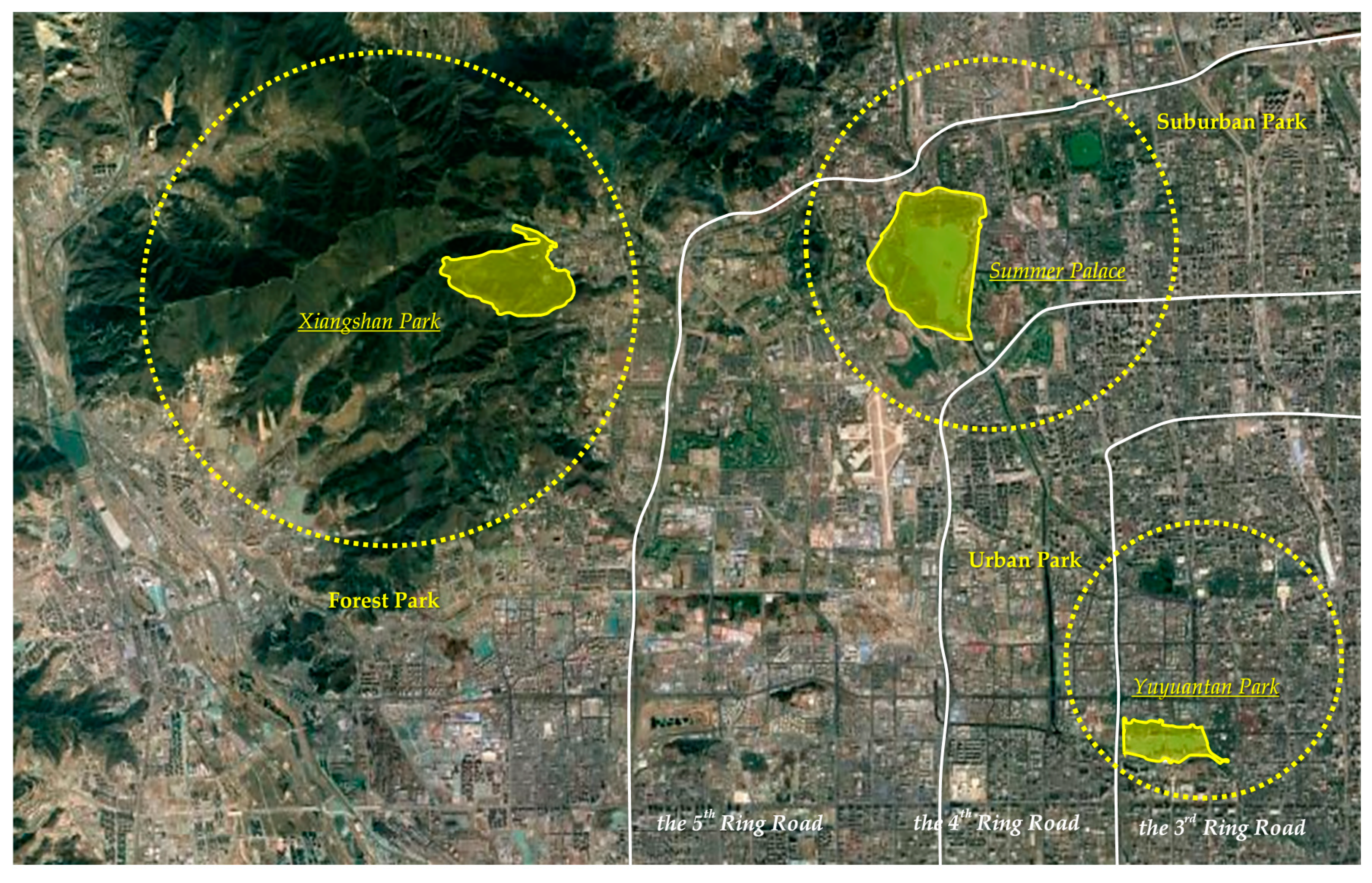
2.1. Selection of Study Areas
- (1)
- Forest parks mainly refer to urban forest areas located in suburban areas with low population density and high forest coverage. Thus, this study selected Xiangshan Park as the representative forest park for investigation. The park is located in the middle of Haidian District, Beijing, outside the Northwest Fifth Ring Road. From a topographic perspective, the park is located at the eastern foot of the Xishan Mountains in Beijing. Xiangshan Park was founded in 1186, and has a history of more than 900 years. It is an ancient royal garden with mountain forest characteristics. In ancient times, the emperor would visit the park to hunt in summer and fall. Xiangshan Park is a national and tourist attraction because it contains famous tourist attractions, including Xiangshan Temple, Hongguang Temple, and Shuangqing Villa. It is also one of the best parks in Beijing. The park contains more than 260,000 trees, with 98% forest coverage. More than 5800 of the trees are ancient, accounting for a quarter of all ancient trees in Beijing. Xiangshan Park is also famous for its red leaves, making it one of the 16 scenic spots in Beijing. Citizens mainly use Xiangshan Park because they only need to travel short distances, as well as for camping and other recreational activities. Yet, the frequency and degree of utilization of this park is lower than other forms of urban forests near the city center.
- (2)
- Suburban parks mainly refer to urban forest areas located at the junction of forest parks and urban areas. Citizens use such urban forests more than forest parks. This study selected the Summer Palace as the representative of suburban park for investigation. The Summer Palace is located between the 4th Ring Road and the 5th Ring Road in the northwest suburb of Beijing, and is 15 km from the urban area. It is a large-scale, landscaped garden built by the design method of gardens in southern China. It is also the most complete royal garden in China. The Summer Palace encompasses more than 3000 palace garden buildings in various forms, including administration, life, and tourism. Today, it is an important place for citizens to spend the summer at leisure. The Summer Palace is one of the four famous gardens in China, and was listed as a world heritage site in November 1998. The current study did not select suburban parks following the method of Hansmann et al. (2007) because the urbanization of Beijing has accelerated recently, with urban forests being used as land for construction, to some extent [22]. The Summer Palace is relatively close to the core of the city, with convenient traffic conditions. However, the population of Beijing has expanded rapidly in recent years, with the population between the 4th and 5th Ring Roads rapidly increasing, thus increasing the frequency and degree of utilization of suburban parks in this region.
- (3)
- Urban parks refer to public parks located in urban areas. Thus, this study selected Yuyuantan Park as the representative urban park for investigation. Urban parks have lower natural resources and forest coverage than other forms of urban forests; however, because they are located in densely populated areas in the city center, urban parks are the most utilized form of park by citizens. Yuyuantan Park has a cherry blossom garden and other characteristic landscapes, as well as amusement parks, boat docks, forest cabins, water parks, and other amusement facilities, plus various kinds of perfect service equipment. The most important role of urban parks is to provide citizens with areas for daily exercise, recreation, and entertainment space. These parks also help regulate the urban microclimate. The construction of urban parks is often closely related to the degree of urbanization. Consequently, the value of these parks is reflected by their actual service functions, rather than historical relics and cultural accumulation.
2.2. Questionnaire Design
2.3. Data Collection
3. Methods and Model Design
3.1. Research Methods
3.2. Description of Variables
4. Results
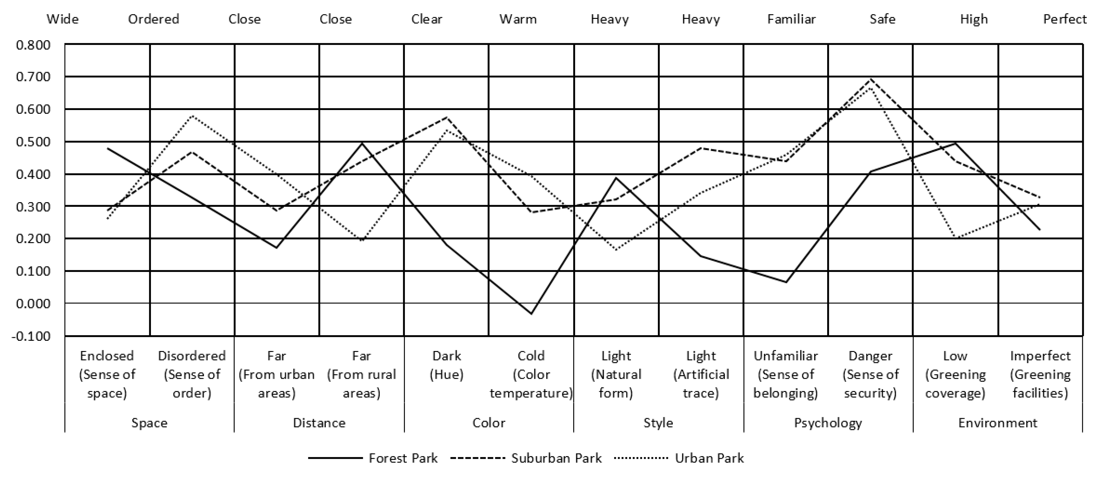
4.1. Regional Differences of Citizens’ Perceptions
4.2. Differences in the Perceptions of Individual Citizens
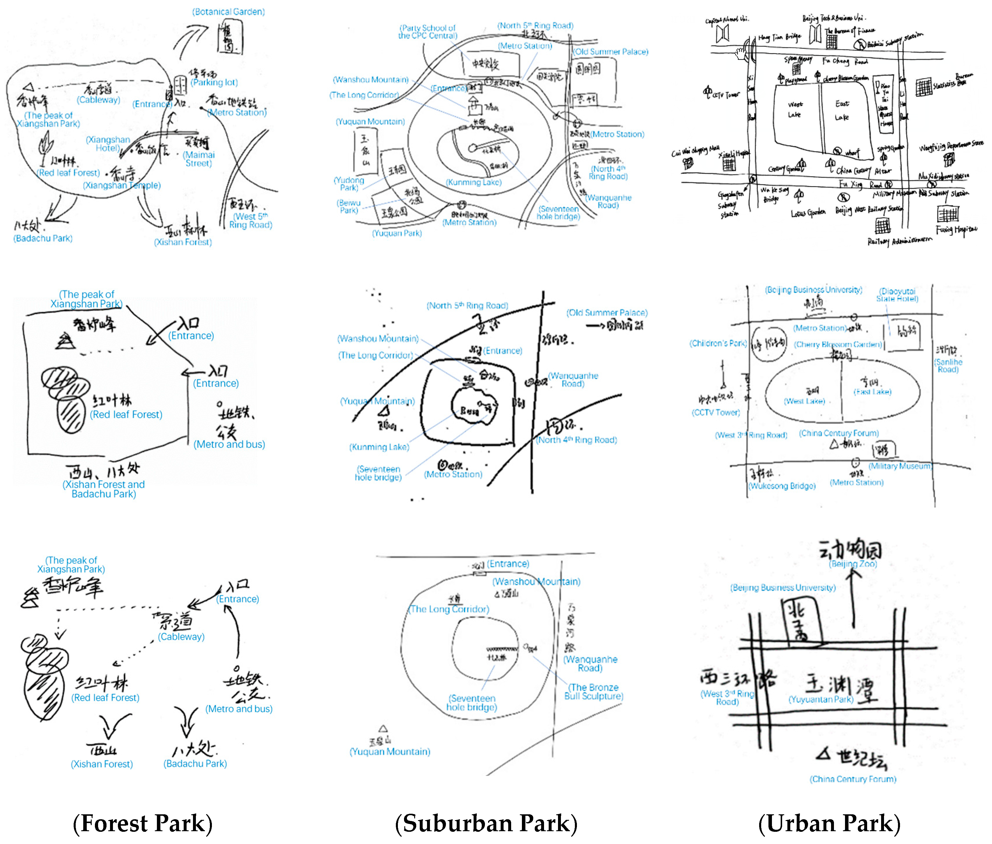
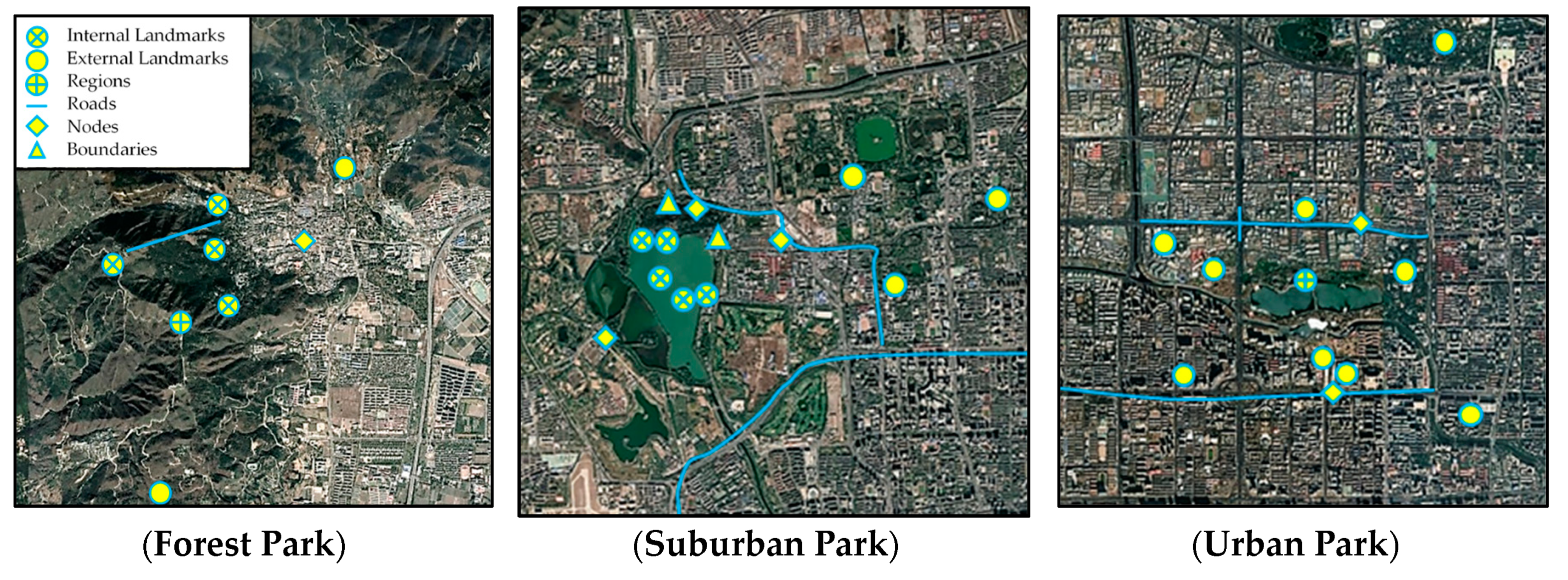
4.3. Cognitive Maps Perceived by Citizens
5. Conclusions
Author Contributions
Funding
Conflicts of Interest
References
- Carlson, A. The aesthetic appreciation of environmental architecture under different conceptions of environment. J. Aesthet. Educ. 2006, 40, 77–88. [Google Scholar] [CrossRef]
- Ren, H.; Zhai, F.; Zhao, H. Exploration of spatial planning and design in urban park activities based on citizen participation. J. Chin. Urban For. 2018, 16, 39–43. [Google Scholar]
- Xi, X.; Fan, L.; Deng, X. An analysis of the results of the public survey on China’s public environmental awareness. China Soft Sci. 1998, 9, 24–30. [Google Scholar]
- Dwyer, J.F.; Nowak, D.J.; Watson, G.W. Future directions for urban forestry research in the United States. J. Arboric. 2002, 5, 231–236. [Google Scholar]
- Gorman, J. Residents’ opinions on the value of street trees depending on tree allocation. J. Arboric. 2004, 30, 36–43. [Google Scholar]
- Sipilä, M.; Tyrväinen, L. Evaluation of collaborative urban forest planning in Helsinki, Finland. Urban For. Urban Green. 2005, 4, 1–12. [Google Scholar] [CrossRef]
- Vries, S.D.; Verheij, R.A.; Groenewegen, P.P.; Spreeuwenberg, P. Natural environments-healthy environments? An exploratory analysis of the relationship between greenspace and health. Environ. Plan. A 2003, 35, 1717–1731. [Google Scholar] [CrossRef] [Green Version]
- Chen, J.; Wang, X.; Yang, X.; Zhu, J.; Shen, Q. Building up a green Beijing- an ambitious urban forestry program. For. Chron. 2013, 89, 127–128. [Google Scholar] [CrossRef] [Green Version]
- Clark, K.H.; Nicholas, K.A. Introducing urban food forestry: A multifunctional approach to increase food security and provide ecosystem services. Landsc. Ecol. 2013, 28, 1649–1669. [Google Scholar] [CrossRef] [Green Version]
- Wang, X.; Wang, C.; Ding, C. Study on Spatial Layout Planning of Forest City Construction in Yangzhou City. J. Jiangsu For. Sci. Technol. 2010, 37, 38–41. [Google Scholar]
- Ruan, W.; Yao, Q.; Shen, L. Discussion on the overall planning of Simen forest town construction in Yuyao City. Acta Agric. Shanghai 2013, 29, 138–141. [Google Scholar]
- Bodin, M.; Hartig, T. Does the outdoor environment matter for psychological restoration gained through running? Psychol. Sport Exerc. 2003, 4, 141–153. [Google Scholar] [CrossRef]
- Pretty, J.; Peacock, J.; Sellens, M.; Griffin, M. The mental and physical health outcomes of green exercise. Int. J. Environ. Health Res. 2005, 15, 319–337. [Google Scholar] [CrossRef]
- Han, M.; Li, Z. Ecological Benefits Evaluation of Urban Forest and Its Models. World For. Res. 2011, 24, 42–46. [Google Scholar]
- Steinberg, T. American Green-the Obsessive Quest for the Perfect Lawn; W. W. Norton & Company: New York, NY, USA, 2006. [Google Scholar]
- Gobster, P.H.; Nassauer, J.I.; Daniel, T.C.; Fry, G. The shared landscape: What does aesthetics have to do with ecology? Landsc. Ecol. 2007, 22, 959–972. [Google Scholar] [CrossRef]
- Brody, S.D.; Highfield, W.; Alston, L. Does location matter? Environ. Behav. 2004, 36, 229–250. [Google Scholar] [CrossRef] [Green Version]
- Nash, R. Wilderness and the American Mind; Yale University Press: New Haven, CT, USA, 2001; pp. 13–19. [Google Scholar]
- Li, X. Geographical Study of Human Settlement Environment; Science Press: Beijing, China, 2015; pp. 106–113. [Google Scholar]
- Zhuang, W. SD Method Related to Evaluation of Architectural Space Objectives. J. Tsinghua Univ. 1996, 36, 42–47. [Google Scholar]
- Llinares, C.; Page, A. Application of product differential semantics to quantify purchaser perceptions in housing assessment. Build. Environ. 2007, 42, 2488–2497. [Google Scholar] [CrossRef]
- Hansmann, R.; Hug, S.M.; Seeland, K. Restoration and stress relief through physical activities in forests and parks. Urban For. Urban Green. 2007, 6, 213–225. [Google Scholar] [CrossRef]
- Huang, Y. The Concept of “Organic Renovation” in the Plan and Reconstruction of Urban Historic Park-On the Base of the Appraisal of Lhasa Zongjiaolukang Park. J. Nanjing For. Univ. 2009, 33, 135–138. [Google Scholar]
- Yu, S.; Yuan, S. A Study on the Integrated Perception of Park Landscape Based on SD Method: A Case Study of Fuzhou. Tour. Sci. 2012, 26, 85–94. [Google Scholar]
- Zhu, J.; Zhang, T.; Chen, Y. Application of SD method to quality assessment of forest recreation space in Beijing. Guangdong Agric. Sci. 2012, 39, 224–227. [Google Scholar]
- Jiang, K. The Research on the Evaluation System of Residential Landscape on SD Method; HeFei University of Technology: Hefei, China, 2012. [Google Scholar]
- Fakeye, P.C.; Crompton, J.L. Image differences between prospective, first-time, and repeat visitors to the lower Rio Grande Valley. J. Travel Res. 1991, 30, 10–16. [Google Scholar] [CrossRef]
- Golledge, R.; Stimpson, R.J. Spatial Behavior: A Geographic Perspective; The Guilford Press: New York, NY, USA, 1997. [Google Scholar]
- Choi, W.M.; Chan, A.; Wu, J. A qualitative and quantitative assessment of Hong Kong’s image as a tourist destination. Tour. Manag. 1999, 20, 361–365. [Google Scholar] [CrossRef]
- Arnberger, A.; Eder, R. The influence of green space on community attachment of urban and suburban residents. Urban For. Urban Green. 2012, 11, 41–49. [Google Scholar] [CrossRef]
- Singleton, R.; Straits, B.C. Approaches to Social Research; Oxford University Press: Oxford, UK, 1999; p. 244. [Google Scholar]
- Ren, L.; Qiu, Z.; Ding, H.; Yan, J. Research on survey quality: Evaluation of the representativeness of survey responses. Society 2014, 34, 196–214. [Google Scholar]
- Zhang, W.; Liu, W.; Li, Y. Housings’ spatial distribution and residents’ preference on housing location in Beijing. Geogr. Res. 2003, 22, 751–759. [Google Scholar]
- Osgood, C.E.; Suci, G.J.; Tannenbaum, P.H. The Measurement of Meaning; University of Illinois Press: Urbana, IL, USA, 1957; Volume 7, pp. 503–504. [Google Scholar]
- Wang, D.; Zhang, Y. Study of Street Space Perception in Shanghai Based on Semantic Differential Method. J. Tongji Univ. 2011, 39, 1000–1006. [Google Scholar]
- Zhao, M.; Shao, L.; Lin, Y. Perceptional Differences of Urban Space between Visitors and Local Residents: A Case Study of West Towns in Nanhai, Guangdong Province. Tour. Sci. 2013, 27, 46–58. [Google Scholar]
- Tolman, E.C. Cognitive maps in rats and men. Psychol. Rev. 1948, 55, 189–208. [Google Scholar] [CrossRef] [Green Version]
- Gao, J. Spatial Cognition and Cognitive Cartography of Maps. In Papers Collection of the Annual Conference of Cartography in China; Sino Maps Press: Beijing, China, 1992; pp. 56–59. [Google Scholar]
- Jiang, Z.; Wu, G.; Bai, G. A Spatial Analysis of the Image of Tourist Destiantions-A Case Study on Ancient Water Towns in Southern Yangtze River. Tour. Trib. 2004, 19, 32–36. [Google Scholar]
- Feng, J. Spatial Cognition and the Image Space of Beijing’s Residents. Sci. Geogr. Sin. 2005, 25, 142–154. [Google Scholar]
- Jiang, Z.; Zhang, J.; Han, G.; Cao, J. A Study Review of Cognitive Maps of Tourists. Tour. Trib. 2009, 24, 77–85. [Google Scholar]
- Lynch, K. The Image of the City; The MIT Press: Cambridge, MA, USA, 1960. [Google Scholar]
- Appleyard, D. Styles and methods of structuring a city. Environ. Behav. 1970, 2, 100–117. [Google Scholar] [CrossRef]
- Hart, R.A.; Moore, G.T. The Development of Spatial Cognition: A Review. In Image and Environment; Downs, R.M., Stea, D., Eds.; Aldine: Chicago, IL, USA, 1973; pp. 246–288. [Google Scholar]
- Siegel, A.W.; White, S.H. The development of spatial representations of large-scale environments. In Advances in Child Development and Behavior; Reese, H.W., Ed.; Academic: New York, NY, USA, 1975. [Google Scholar]
- Allen, G.L. The organization of route knowledge. New Dir. Child Adolesc. Dev. 1982, 15, 31–39. [Google Scholar] [CrossRef]
- Xue, L.; Shen, S.; Liu, Y. The Comparison between Two Cognitive Map Externalization Methods: A Case Study of Beijing. Acta Sci. Nat. Univ. Pekin. 2007, 44, 413–420. [Google Scholar]
- Zhang, C.; Bai, K.; Ma, Y. The research on inbound tourists’ cognition sequence for spatial image of urban destinations in Xi’an. Geogr. Res. 2014, 33, 1315–1334. [Google Scholar]
- Wu, Y.; Xiao, B. Landscape Design and Integration of City Public Open Space. J. Northwest For. Univ. 2010, 25, 188–191. [Google Scholar]


| Variable | Forest Park | Suburban Park | Urban Park | Variable | Forest Park | Suburban Park | Urban Park |
|---|---|---|---|---|---|---|---|
| (X1) Gender | (X8) Health status | ||||||
| Men | 42.67 | 48.67 | 51.33 | Very good | 2.00 | 1.33 | 0.67 |
| Women | 57.33 | 51.33 | 48.67 | Relatively good | 27.33 | 18.67 | 24.67 |
| (X2) Age | Commonly | 40.67 | 54.00 | 45.33 | |||
| Age 17 and under | 0.67 | 3.33 | 0.67 | Relatively poor | 24.67 | 24.67 | 26.67 |
| 18–29 years old | 59.33 | 34.00 | 34.00 | Very poor | 5.33 | 1.33 | 2.67 |
| 30–39 years old | 19.33 | 36.67 | 24.00 | (X9) Beijing residence registration status | |||
| 40–49 years old | 11.33 | 13.33 | 13.33 | Have | 26.67 | 42.00 | 52.00 |
| 50–59 years old | 6.00 | 6.67 | 15.33 | No | 73.33 | 58.00 | 48.00 |
| Age 60 and over | 3.33 | 6.00 | 12.67 | (X10) Residence in Beijing | |||
| (X3) Education status | Within 1 years | 16.67 | 8.67 | 11.33 | |||
| Primary school and below | 2.67 | 3.33 | 2.67 | 1 to 5 years | 40.67 | 25.33 | 24.67 |
| Junior middle school | 6.00 | 14.00 | 8.00 | 5 to 10 years | 14.67 | 16.67 | 9.33 |
| High school | 25.33 | 14.67 | 26.00 | 10 to 15 years | 8.67 | 14.00 | 12.67 |
| Undergraduate | 56.00 | 42.67 | 40.67 | 15 years or more | 19.33 | 35.33 | 42.00 |
| Master and above | 10.00 | 25.33 | 22.67 | (X11) Months of residence in Beijing every year | |||
| (X4) Marital status | Within 3 months | 12.00 | 3.33 | 5.33 | |||
| Unmarried | 59.33 | 42.00 | 34.00 | 3–6 months | 6.00 | 2.67 | 6.67 |
| Married | 40.67 | 58.00 | 66.00 | 6–9 months | 16.67 | 19.33 | 12.67 |
| (X5) Family size | More than 9 months | 65.33 | 74.67 | 75.33 | |||
| 1 person | 7.33 | 10.00 | 8.67 | (X12) Per capita monthly income | |||
| 2 persons | 14.67 | 13.33 | 12.00 | ¥4000 and below | 39.33 | 24.67 | 30.00 |
| 3 persons | 34.00 | 32.67 | 40.00 | ¥4001–¥8000 | 27.33 | 26.67 | 26.67 |
| 4 persons | 24.67 | 28.00 | 26.67 | ¥8001–¥12,000 | 14.00 | 22.67 | 20.67 |
| 5 persons or more | 19.33 | 16.00 | 12.67 | ¥12,001–¥16,000 | 9.33 | 8.00 | 9.33 |
| (X6) Number of elderly people | ¥16,001–¥20,000 | 5.33 | 9.33 | 6.00 | |||
| 1 person or less | 50.67 | 50.67 | 58.00 | More than 20,000 | 4.67 | 8.67 | 7.33 |
| 2 persons | 31.33 | 36.67 | 28.67 | (X13) Residential area | |||
| 3 persons or more | 18.00 | 12.67 | 13.33 | Within 2nd Ring Rd | 4.00 | 6.00 | 14.67 |
| (X7) Number of children | 2nd–3rd Ring Road | 8.67 | 10.00 | 35.33 | |||
| 1 person or less | 80.00 | 74.00 | 81.33 | 3rd–4th Ring Road | 17.33 | 28.67 | 21.33 |
| 2 persons | 12.00 | 15.33 | 11.33 | 4th–5th Ring Road | 32.00 | 29.33 | 14.00 |
| 3 persons or more | 8.00 | 10.67 | 7.33 | 5th–6th Ring Road | 26.67 | 22.67 | 13.33 |
| Beyond 6th Ring Road | 11.33 | 3.33 | 1.33 | ||||
| Category | Symbol | Variable | Index | Definition |
|---|---|---|---|---|
| Space | M1 | Sense of space | Enclosed–Wide | Spatial looseness and intensity of urban forest |
| M2 | Sense of order | Disordered–Ordered | Orderliness and orderliness of urban forests | |
| Distance | M3 | From urban areas | Far–Close | Distance between urban forests and urban areas |
| M4 | From rural areas | Far–Close | Distance between urban forest and rural areas | |
| Color | M5 | Hue | Dark–Clear | Brightness and contrast of urban forest |
| M6 | Color temperature | Cold–Warm | Overall hues of urban forests | |
| Style | M7 | Natural form | Light–Heavy | Natural form degree of urban forest |
| M8 | Artificial trace | Light–Heavy | Artificial trace degree of urban forest | |
| Psychology | M9 | Sense of belonging | Unfamiliar–Familiar | The sense of belonging and familiarity of urban forests |
| M10 | Sense of security | Danger–Safe | Public security management of urban forests | |
| Environment | M11 | Greening coverage | Low–High | Greening coverage of urban forests |
| M12 | Greening facilities | Imperfect–Perfect | Improvement of greening facilities in urban forests |
| Category | Symbol | Variable | Forest Park and Suburban Park | Forest Park and Urban Park | Suburban Park and Urban Park | |||
|---|---|---|---|---|---|---|---|---|
| F | Sig. | F | Sig. | F | Sig. | |||
| Space | M1 | Sense of space | 0.983 | 0.322 | 2.141 | 0.144 | 0.281 | 0.597 |
| M2 | Sense of order | 3.612 * | 0.058 | 0.511 | 0.475 | 1.581 | 0.210 | |
| Distance | M3 | From urban areas | 1.441 | 0.231 | 0.596 | 0.441 | 0.243 | 0.622 |
| M4 | From rural areas | 1.078 | 0.300 | 0.052 | 0.820 | 1.306 | 0.254 | |
| Color | M5 | Hue | 1.138 | 0.287 | 0.310 | 0.578 | 0.344 | 0.558 |
| M6 | Color temperature | 4.220 ** | 0.041 | 0.309 | 0.579 | 3.427 * | 0.065 | |
| Style | M7 | Natural form | 3.855 * | 0.051 | 0.940 | 0.333 | 7.457 *** | 0.007 |
| M8 | Artificial trace | 2.316 | 0.129 | 0.001 | 0.973 | 2.979 * | 0.085 | |
| Psychology | M9 | Sense of belonging | 5.791 ** | 0.017 | 2.557 | 0.111 | 0.905 | 0.342 |
| M10 | Sense of security | 0.221 | 0.639 | 0.135 | 0.714 | 0.768 | 0.381 | |
| Environment | M11 | Greening coverage | 0.815 | 0.367 | 1.334 | 0.249 | 0.094 | 0.759 |
| M12 | Greening facilities | 5.242 ** | 0.023 | 0.002 | 0.962 | 5.538 ** | 0.019 | |
| Variable | M1 | M2 | M3 | M4 | M5 | M6 | M7 | M8 | M9 | M10 | M11 | M12 | |
|---|---|---|---|---|---|---|---|---|---|---|---|---|---|
| Characteristics | |||||||||||||
| X1 | 0.005 | −0.059 | −0.011 | −0.056 | −0.077 * | −0.052 | −0.083 * | −0.053 | −0.079 * | 0.026 | 0.048 | −0.082 * | |
| X2 | −0.030 | 0.104 ** | 0.067 | −0.031 | 0.044 | 0.148 *** | 0.033 | 0.053 | 0.032 | −0.001 | −0.024 | 0.052 | |
| X3 | −0.038 | −0.151 *** | 0.021 | −0.018 | −0.169 *** | −0.080 * | −0.094 ** | −0.069 | −0.090 * | 0.025 | 0.011 | −0.113 ** | |
| X4 | −0.083 * | 0.045 | 0.077 * | −0.032 | 0.019 | 0.149 *** | 0.026 | 0.033 | 0.037 | −0.002 | −0.023 | 0.032 | |
| X5 | 0.002 | 0.075 | −0.026 | 0.031 | 0.073 | −0.035 | 0.056 | 0.036 | −0.002 | 0.130 *** | 0.009 | 0.016 | |
| X6 | 0.009 | −0.034 | 0.008 | 0.017 | −0.041 | 0.034 | −0.013 | −0.016 | 0.086 | −0.080 * | −0.044 | 0.014 | |
| X7 | −0.009 | 0.014 | 0.037 | 0.006 | 0.048 | 0.018 | 0.107 ** | 0.082 * | 0.015 | −0.038 | 0.034 | 0.043 | |
| X8 | 0.047 | 0.036 | 0.044 | −0.041 | 0.075 | 0.043 | 0.054 | 0.001 | 0.069 | 0.003 | −0.009 | 0.119 ** | |
| X9 | 0.060 | 0.009 | −0.086 * | 0.021 | 0.032 | −0.086 * | 0.029 | 0.001 | −0.038 | 0.011 | 0.073 | 0.026 | |
| X10 | −0.046 | 0.013 | 0.078 * | −0.070 | 0.050 | 0.115 ** | 0.020 | 0.039 | 0.075 | 0.000 | −0.041 | 0.000 | |
| X11 | 0.066 | 0.003 | 0.031 | −0.032 | −0.024 | 0.022 | −0.015 | 0.023 | −0.012 | 0.017 | −0.040 | −0.084 * | |
| X12 | −0.019 | −0.117 ** | −0.078 * | −0.031 | −0.113 ** | −0.025 | −0.094 ** | −0.060 | −0.029 | −0.011 | −0.074 | −0.040 | |
| X13 | 0.032 | −0.050 | −0.032 | 0.095 ** | −0.056 | −0.124 *** | 0.047 | −0.002 | −0.072 | −0.059 | −0.010 | −0.040 | |
| Types | Sequential Cognitive Maps | Spatial Cognitive Maps | |||||
|---|---|---|---|---|---|---|---|
| Index | Linear | Branch | Chain | Scattered | Mosaic | Connected | |
| Quantity | 78 | 90 | 70 | 59 | 72 | 79 | |
| Proportion (%) | 17.41% | 20.09% | 15.63% | 13.17% | 16.07% | 17.63% | |
| Index | Scheme 1 ln (P1/P6) | Scheme 2 ln (P2/P6) | Scheme 3 ln (P3/P6) | Scheme 4 ln (P4/P6) | Scheme 5 ln (P5/P6) | Type of Cognitive Maps | |||||
|---|---|---|---|---|---|---|---|---|---|---|---|
| B | Exp (B) | B | Exp (B) | B | Exp (B) | B | Exp (B) | B | Exp (B) | ||
| Age | |||||||||||
| 18–29 | 0.31 | 1.37 | 0.99 | 2.68 | −0.20 | 0.82 | 1.38 | 3.96 | 1.94 * | 6.95 | Mosaic |
| 30–39 | 1.12 | 3.05 | 0.83 | 2.28 | 0.56 | 1.74 | 2.28 ** | 9.76 | 1.56 * | 4.75 | Scattered |
| 40–49 | 1.05 | 2.85 | 1.28 | 3.61 | 0.31 | 1.36 | 3.11 *** | 22.49 | 1.69 * | 5.40 | Scattered |
| Education status | |||||||||||
| High school | −1.14 * | 0.32 | −0.70 | 0.50 | −0.74 | 0.48 | −1.16 | 0.31 | −0.49 | 0.61 | Connected |
| Marital status | |||||||||||
| Unmarried | 1.18 ** | 3.26 | 0.49 | 1.64 | 0.69 | 1.99 | 0.26 | 1.29 | 0.28 | 1.33 | Linear |
| Family size | |||||||||||
| 1 person | 0.38 | 1.46 | 1.56 ** | 4.74 | 0.19 | 1.21 | 1.99 ** | 7.30 | 0.88 | 2.40 | Scattered |
| 2 persons | 1.08 | 2.94 | 1.39 ** | 4.00 | 0.86 | 2.36 | 2.04 *** | 7.67 | 1.07 | 2.91 | Scattered |
| 3 persons | 0.54 | 1.72 | 0.78 | 2.17 | 0.24 | 1.27 | 1.25 * | 3.48 | 0.82 | 2.27 | Scattered |
| 4 persons | 0.06 | 1.06 | 0.86 | 2.37 | 0.74 | 2.10 | 1.58 * | 4.85 | 0.42 | 1.52 | Scattered |
| Number of elderly people | |||||||||||
| 1 person or less | −0.39 | 0.67 | −0.98 * | 0.38 | −0.50 | 0.61 | −0.66 | 0.52 | −0.18 | 0.83 | Connected |
| Health status | |||||||||||
| Relatively good | −1.95 | 0.14 | −1.68 * | 0.19 | −1.78 * | 0.17 | −0.59 | 0.56 | −2.96 ** | 0.05 | Connected |
| Commonly | −0.53 | 0.59 | 0.10 | 1.10 | −0.35 | 0.70 | −1.00 | 0.37 | −0.93 * | 0.40 | Branch |
| Residence in Beijing | |||||||||||
| Within 1 years | −0.46 | 0.63 | −0.62 | 0.54 | 0.52 | 1.69 | −2.01 * | 0.13 | −0.88 | 0.42 | Chain |
| 5 to 10 years | −0.86 | 0.42 | −1.35 * | 0.26 | 0.27 | 1.31 | −1.52 * | 0.22 | −0.84 | 0.43 | Chain |
| 10 to 15 years | −0.19 | 0.83 | 1.19 * | 3.27 | 0.55 | 1.73 | 0.82 | 2.28 | 0.74 | 2.10 | Branch |
| Months of residence in Beijing every year | |||||||||||
| Within 3 months | 0.59 | 1.80 | 0.36 | 1.43 | 0.88 | 2.40 | 2.05 * | 7.76 | 1.47 | 4.34 | Scattered |
| Per capita monthly income | |||||||||||
| ¥4000 and below | 1.74 ** | 5.67 | 1.19 | 3.28 | −0.06 | 0.94 | 1.27 | 3.55 | 2.47 *** | 11.86 | Mosaic |
| ¥4001–¥8000 | 1.22 | 3.40 | 1.33 * | 3.79 | 0.20 | 1.22 | 1.82 ** | 6.20 | 2.02 ** | 7.53 | Mosaic |
| ¥12,001–¥16,000 | 1.83 ** | 6.22 | 1.00 | 2.72 | 0.59 | 1.81 | 1.78 * | 5.94 | 2.28 ** | 9.79 | Mosaic |
| ¥16,001–¥20,000 | 0.41 | 1.50 | 1.53 | 4.64 | 0.95 | 2.58 | 1.59 * | 4.88 | 2.46 ** | 11.65 | Mosaic |
| Residential area | |||||||||||
| 5th–6th Ring Rd | 0.00 | 1.00 | 0.20 | 1.22 | −0.77 | 0.46 | 2.13 * | 8.43 | 0.47 | 1.60 | Scattered |
| C | −1.65 | − | −1.81 | − | −0.04 | − | −5.41 ** | − | −3.52 * | − | − |
© 2020 by the authors. Licensee MDPI, Basel, Switzerland. This article is an open access article distributed under the terms and conditions of the Creative Commons Attribution (CC BY) license (http://creativecommons.org/licenses/by/4.0/).
Share and Cite
Zhao, Z.; Ren, J.; Wen, Y. Spatial Perception of Urban Forests by Citizens Based on Semantic Differences and Cognitive Maps. Forests 2020, 11, 64. https://doi.org/10.3390/f11010064
Zhao Z, Ren J, Wen Y. Spatial Perception of Urban Forests by Citizens Based on Semantic Differences and Cognitive Maps. Forests. 2020; 11(1):64. https://doi.org/10.3390/f11010064
Chicago/Turabian StyleZhao, Zheng, Jie Ren, and Yali Wen. 2020. "Spatial Perception of Urban Forests by Citizens Based on Semantic Differences and Cognitive Maps" Forests 11, no. 1: 64. https://doi.org/10.3390/f11010064
APA StyleZhao, Z., Ren, J., & Wen, Y. (2020). Spatial Perception of Urban Forests by Citizens Based on Semantic Differences and Cognitive Maps. Forests, 11(1), 64. https://doi.org/10.3390/f11010064