1. Introduction
In 1999, to curb soil erosion and related forms of environmental degradation, the government of China launched the “Returning Farmland to Forests Program” (RFFP, also translated as the Sloping Land Conversion Program and the Grain for Green Program). The core of the project is to plant trees or grass on sloping and desertified lands withdrawn from grain production where soil erosion is serious or grain yield is low and unstable or important ecosystem services require protection [
1]. By 2013, the government had invested ¥320 billion—involving 32 million households—in planting trees over an area exceeding 29 million hectares [
2,
3]. Over the 18 years since its initiation, observers have attributed substantial ecological and social benefits to the RFFP, although concerns including biologically poor monoculture plantations, uneven survival rates, and unfairness in implementation have also arisen [
4,
5,
6]. The three major goals of the policy are a stable supply of forest products, the improvement of rural livelihoods, and the protection and restoration of ecological systems. However, conflicts and contradictions can arise among these goals, and differences in the effectiveness of implementation are evident across locations and at various scales [
7,
8].
The spatial distribution of changes in forest cover at different scales varies, and considerable uncertainty exists regarding the effectiveness of the policy in increasing forest cover [
9]. At the large scale, research shows that the RFFP has increased forest cover and changed the type of land use [
10,
11,
12,
13,
14,
15,
16,
17]. Simultaneously, the policy contributes to structural changes in rural economies and increases in household incomes [
18,
19,
20]. However, small-scale studies suggest that ecosystem service programs and policies that encourage forest restoration have not been entirely successful and that changes in forest cover vary widely [
21,
22]. The direction of forest cover change is inconsistent, even decreasing in some areas [
18,
23,
24]. In a separate study on the impact of the RFFP, Trac, et al. [
25] found that it did not achieve the expected ecological benefits at the township level because of economic problems or inappropriate selection of tree species. Recent studies suggest that other factors that covary with RFFP implementation may account for much of the vegetation gains attributed to the program [
26]. With differences in the effectiveness of the RFFP in promoting increased forest cover, the changes in landscape patterns are also likely to differ [
27,
28,
29]. Therefore, further considerations should be given to the question of whether the RFFP drives community-level changes in landscape patterns in China.
The landscape is a perfect example of where the combined effects of society and nature become visible. As societies and nature are dynamic, change is an inherent characteristic of landscapes [
30]. The drivers of changes in land use and the landscape pattern have been examined in many studies [
28,
30,
31]. For instance, the effect of the RFFP on landscape patterns at a large scale revealed that forest fragmentation has decreased and the fragmentation of both farmland and ecosystem pattern has increased [
32,
33,
34]. However, the RFFP affects landscape patterns differently at the medium and small scales [
35]. This research shows that the implementation of the RFFP varies across regions [
36]. Even within the same county, farmers in different towns and villages may receive different subsidies and show a varying willingness to participate. At a small scale, studies show that households who take part in the RFFP will reallocate farmland [
35,
37], but the evidence also shows that those who are not involved do the same [
18,
38]. These results suggest that other factors have a greater impact on farmland reallocation systems than RFFP, and RFFP may not directly affect these decisions [
39]. In addition to the RFFP, socioeconomic, political, technological, ecological, and cultural factors may be primary drivers of landscape pattern change [
36,
40,
41,
42,
43]. The study of Weng [
44] demonstrated the impact of urbanization on landscape change by integrating the spatial and the temporal perspectives.
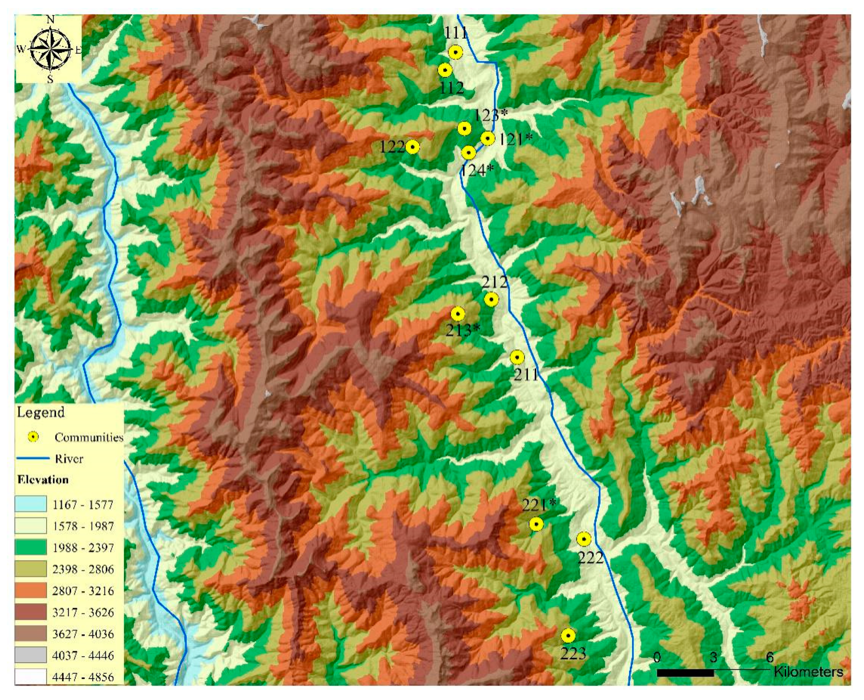
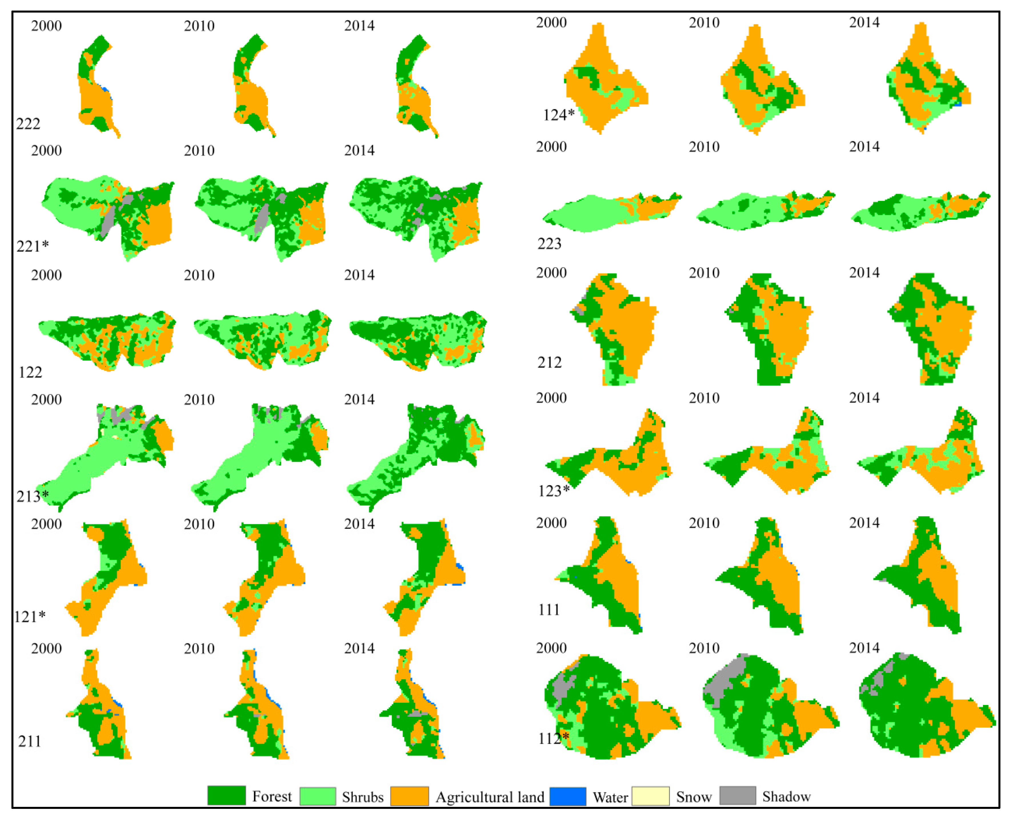
Most studies of RFFP focus on the time series analysis of large-scale landscape patterns, but the transect analysis and different patterns that exist at small scales are ignored. In this study, to evaluate the role of the RFFP in affecting the landscape pattern at the community level, 12 communities were selected in Weixi Lisu Autonomous County, Diqing Prefecture, with five communities that implemented the RFFP and seven communities that did not. The results of earlier studies in this region indicate that forest vegetation cover increased significantly from 2000 to 2014 [
26,
43]; however, no significant correlation was detected between the implementation of the RFFP and changes in vegetation cover at the community level. Therefore, the RFFP was not a direct cause of the changes in forest cover, although the combination of the RFFP and other factors may have played a role. Changes in forest cover inevitably cause changes in landscape patterns [
9,
45], and the regional landscape pattern is also likely impacted by the requirement of relevant government departments for continuous land conversion [
25,
46,
47]. It is anticipated that widespread farmland retirement and the restoration of vegetation under RFFP would reduce forest fragmentation but increase farmland fragmentation. Based on these expectations, the landscape patterns between communities with and without RFFP should be different. Thus, this study addressed the following questions: Is there a significant difference in landscape patterns and fragmentation between communities that did and did not implement the RFFP in 2000, 2010, and 2014? Is there a significant difference in landscape pattern changes between the communities that did and did not implement the RFFP from 2000 to 2014? Are the changes in land use cover and landscape pattern caused by the implementation of the RFFP? Expanding on our previous work, which was limited to the change in forest cover, this study analyzes the impact of the RFFP on farmland, shrubland, forests, and the entire landscape pattern at the community level and explores the driving forces of landscape pattern change, combining environmental and socioeconomic data. The results of this study can provide guidance for the smooth development of forest restoration policies succeeding the RFFP and also serve as a basis for evaluating the impacts of RFFP relative to policy goals. More specifically, the study can provide a scientific basis for the planning and utilization of land resources in Weixi County and a reference point for realizing sustainable development in this region.
4. Discussion
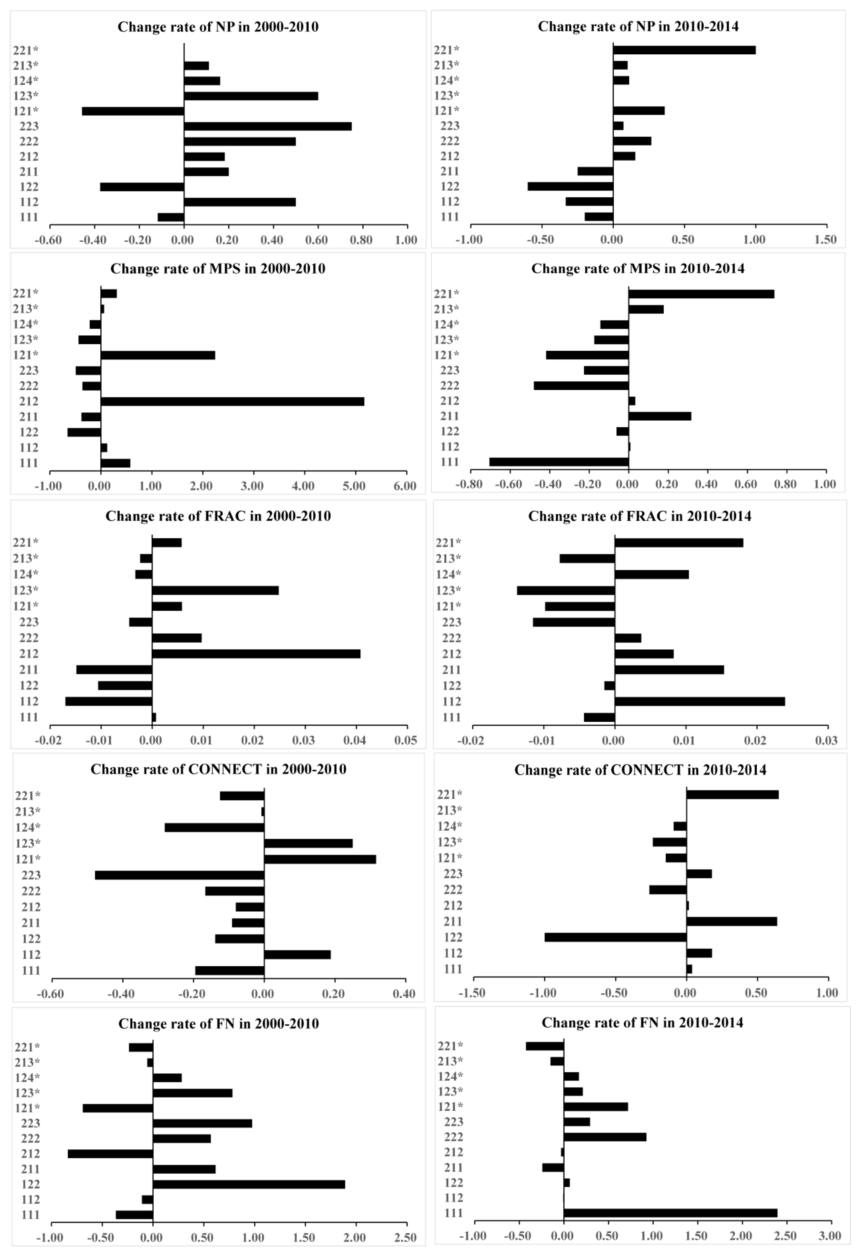
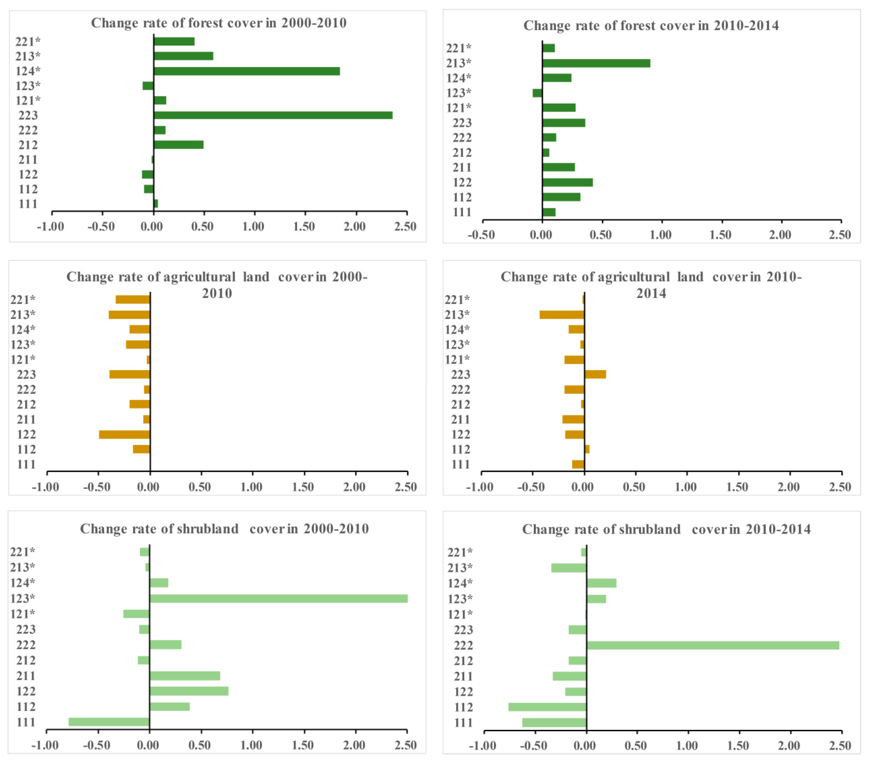
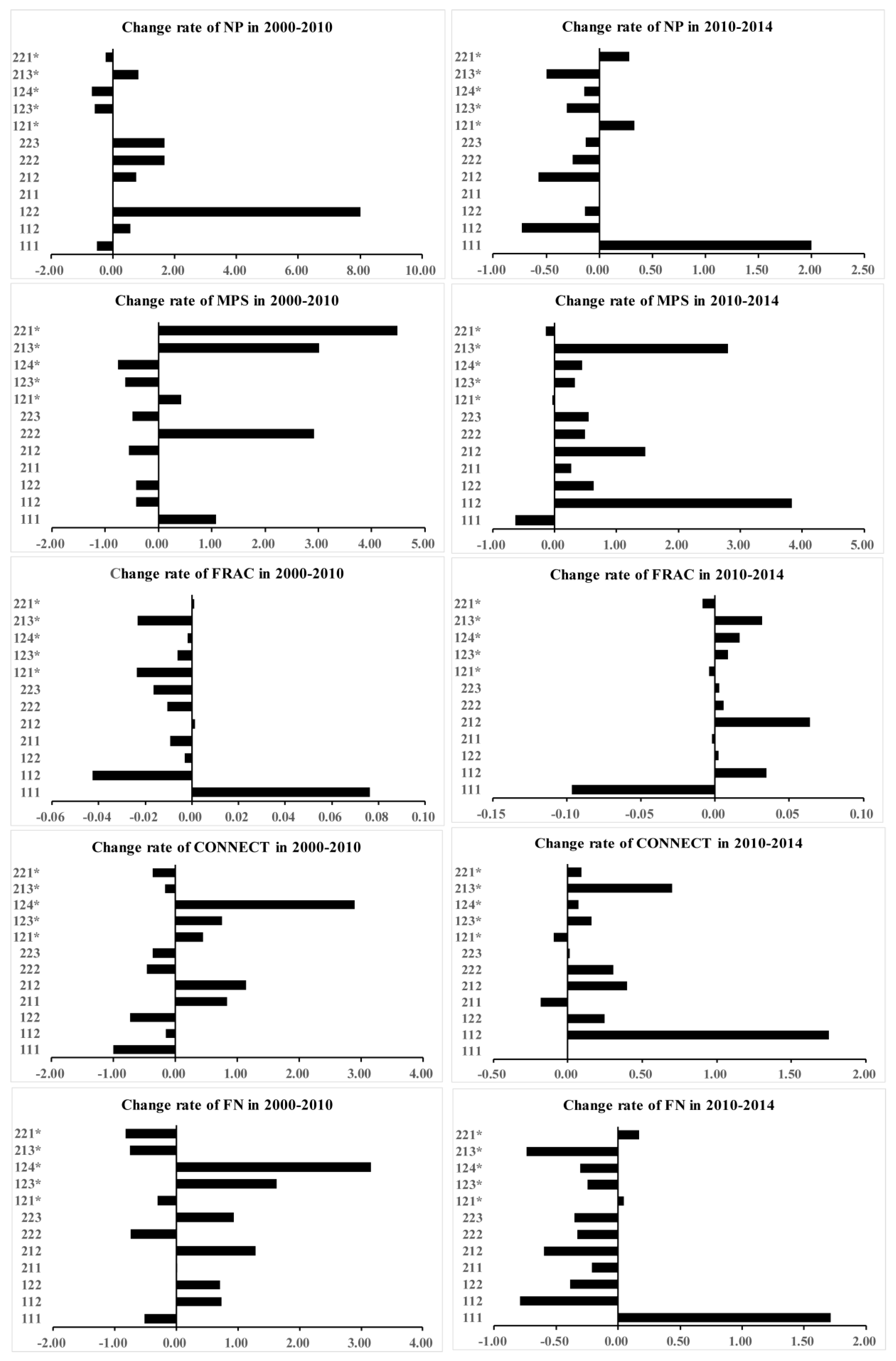
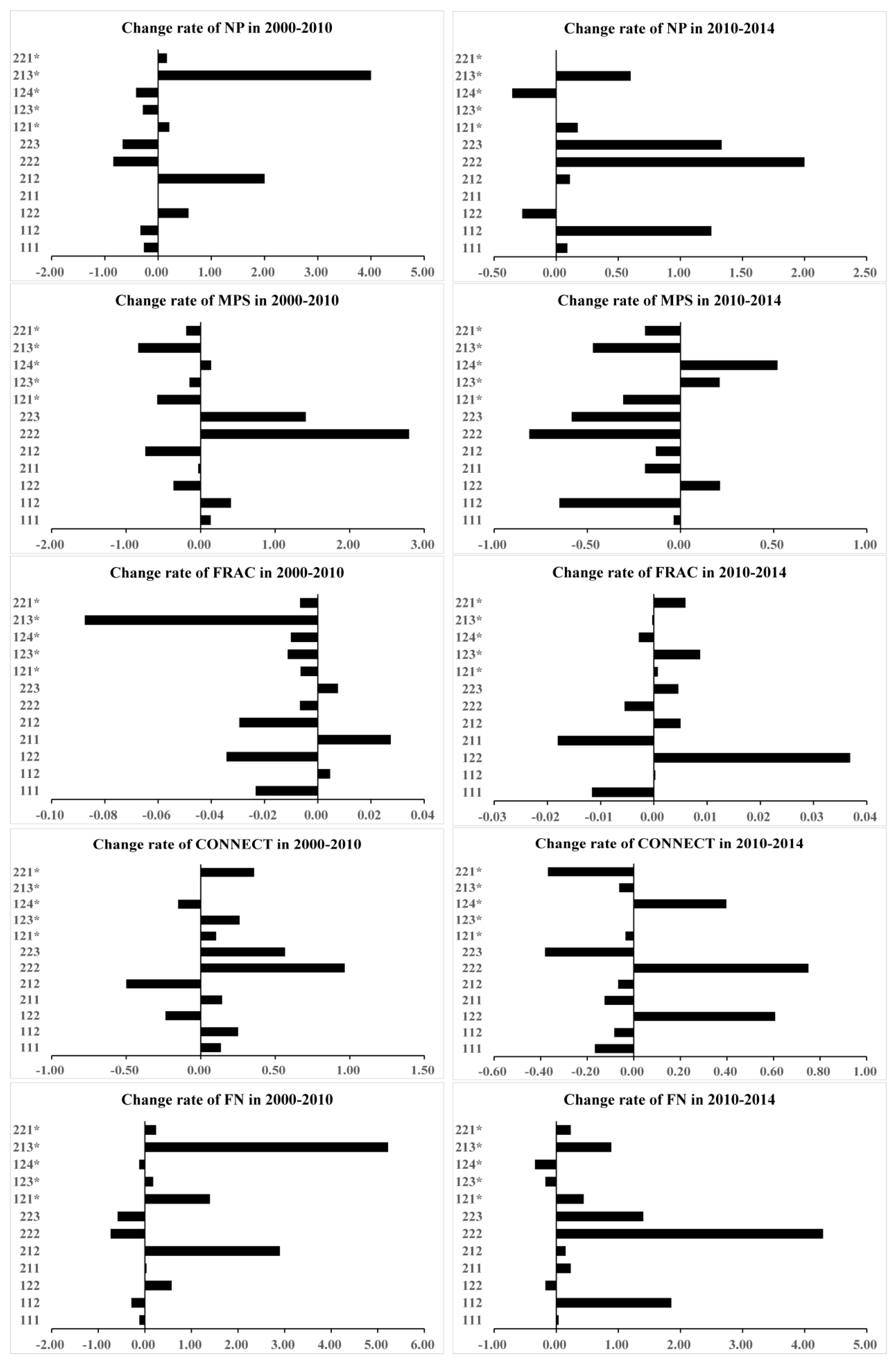
The differences in landscape pattern and fragmentation between RFFP and non-RFFP communities during 2000–2014 were quantitatively compared and validated using of the NP, MPS, FRAC, CONNECT, LFI, and SHDI indices at the landscape level and NP, MPS, FRAC, CONNECT, and FN indices at the class-level. To further examine the driving forces affecting changes in landscape fragmentation in the study area, these indices were regressed on variables representing environmental and socioeconomic factors. In 2000, 2010, and 2014, no significant differences were observed between RFFP and non-RFFP communities in forest, shrubland, agricultural land, and the entire landscape pattern metrics or in their fragmentation. Moreover, no significant differences (
P > 0.05) were observed in the change rate of each landscape/class index between RFFP and non-RFFP communities from 2000 to 2010, 2010 to 2014, and 2000 to 2014. The primary observations were the reduction in agricultural land area that became more fragmented and the restoration of vegetation that resulted in the benign transformation of the landscape pattern. From 2000 to 2010, the landscape patterns and their dynamic changes between RFFP and non-RFFP communities were variable, with large individual differences among the communities. The RFFP had no significant influence on forests, shrubland, agricultural land, or the entire landscape. After 2010, the fragmentation of the entire landscape increased in both types of communities, with a decrease in forest fragmentation and an increase in agricultural land and shrubland fragmentation. Thus, the RFFP was still not the primary and direct reason for the dynamic changes in forests, shrubland, agricultural land, or the entire landscape pattern in recent years. Many studies suggest vegetation has been restored and forest connectivity and integrity has improved because of the high proportion of agricultural land and bare land converted into forest, shrubland, and grassland. Although forest fragmentation has been effectively restrained, the cover of agricultural land has been greatly reduced and its fragmentation has increased; as a result, the entire landscape pattern is more fragmented [
34,
37,
76]. These results are consistent with those of our study. However, the previous research was based on longitudinal analysis from a time series and focused on the changes in land use and landscape pattern in a certain region before and after the implementation of the RFFP. In the absence of a horizontal comparison, all the changes were attributed to the RFFP, and a pseudo-relationship was established between the RFFP and changes in land use and landscape pattern. Those studies ignored the fact that there might not be an inevitable connection between the changes in landscape pattern and the RFFP [
77].
Landscape structure and composition may change dramatically over time in a variety of landscapes [
40]. In sustainable landscape development, humans alter the landscape to improve its functionality and create additional value [
78,
79]. When spatial planning policy is decentralized, local actors should collaborate to decide on the appropriate changes for the landscape to better accommodate their perceived values [
80,
81]. Facilitating afforestation requires the coordination of land users, officials, and bureaucrats who will have varying concerns and interests in terms of identifying land to be afforested, assemble seedlings, and plant and tend trees. Conflicts and contradictions can arise regarding the means for the improvement of rural livelihoods and the protection and restoration of ecological systems [
7,
8]. On this basis, the RFFP may not promote the benign transformation of landscape patterns. Meanwhile, rural communities are undergoing rapid social, political, economic and cultural transitions, which directly and indirectly influence the way society interacts with the environment, which in turn can cause rapid change in rural landscape [
82]. Hence, landscape pattern changes are strongly affected by the economic, sociocultural and ecological values demanded by its users.
The results of this study showed no significant differences in forests, shrubland, agricultural land, and the overall landscape pattern between RFFP and non-RFFP communities. The dynamic changes were also the same in the two types of communities. These results indicated that the RFFP may not be the most direct cause of changes in the landscape pattern in the study area at the community level; however, the RFFP may act on the landscape pattern together with other natural and economic factors [
40,
47]. To protect and improve the environmental quality in Weixi County, the RFFP and the NFPP have been implemented since 2002. In 2008, to increase the income of households and develop the local economy, the government started to encourage the planting of tree crops—particularly walnuts. In 2010, the policy of “linking villages with roads” was implemented, and rural roads were built to connect all villages with asphalt or cement roads. These multiple measures and policies may cause changes in land use and landscape patterns that are interwoven. Therefore, an in-depth analysis should be conducted of the primary driving forces for dynamic changes in the landscape pattern according to the actual local situation to adapt measures to local conditions [
45]. Data from interviews and focus group discussions show that at the same time as RFFP was being used to encourage farmland retirement, households in both participating and non-participating communities took marginal, high-elevation farmland out of production. While households in communities that implemented RFFP received subsidies to retire farmland and plant trees, initial tree-planting efforts had limited success. As a result, the program’s impact on landscapes was obscured by other factors. In 2008, the government began to encourage walnut cultivation, initially in low-elevation riverside communities in which the climate, soil, and other natural conditions are suitable for walnut growth. By 2010, the “linking villages with roads” program was implemented. Roads brought connectivity between communities and markets that facilitated walnut production [
38,
43]. Other changes in livelihoods during this period include the adoption of cash crops such as runner beans, maca, and costus root, as well as increasing off-farm labor allocation, varying in magnitude across communities. Under the combined action of government policies, market shifts, infrastructure construction, urbanization, and many other factors, some of the agricultural land in the study region was transformed into vegetation, increasing vegetation coverage, although much of the increase was due to the economic forests. Altogether, forest fragmentation decreased in both RFFP and non-RFFP communities during 2000–2014, with the decrease particularly pronounced after 2010, as the gradual effects of farmland retirement generating vegetation through tree cultivation or forest succession became evident. Thus, vegetation cover increased and forest landscape patterns were consolidated in the study area, which is consistent with government objectives [
9], but the fragmentation of the overall landscape pattern increased [
35].
Fragmentation and landscape metrics at the landscape level were not significantly different between RFFP and non-RFFP communities, indicating that the RFFP did not cause differences in the landscape pattern at the community level. Looking at change over time, from 2000 to 2014, landscape fragmentation increased in communities with and without the RFFP, possibly due to the implementation of the “linking villages with roads” policy in this region. The construction of roads and the development of some economic activities often causes the fragmentation of vegetation, rivers, and other landscape features [
83,
84]. Regression results showed that the nearness to a township and elevation—not the RFFP—were the main environmental factors that affected change in overall landscape patterns. Communities that are closer to towns and lower in elevation have higher landscape fragmentation than those farther away at higher elevation, which may be due to more frequent infrastructure construction and economic activity that occurs in these communities [
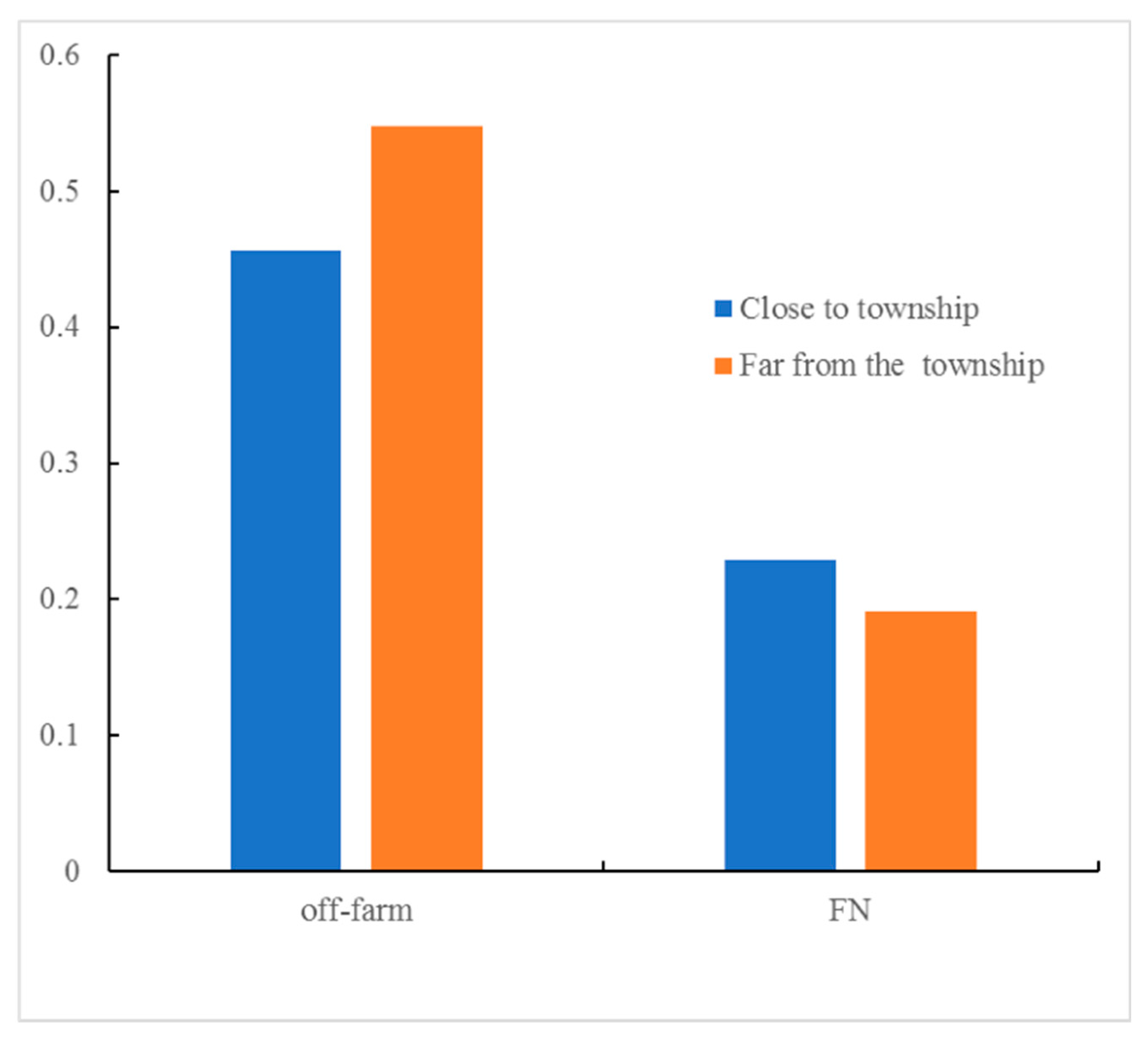
85]. As a result, the landscape segmentation and the number of patches increased, the mean patch area and the connectivity decreased, and the landscape fragmentation increased. The nearness to a township was also an important driving force for the change in forest fragmentation patterns, although the contribution of the RFFP was again not significant. In communities far from a township, because of the lack of transportation and over-reliance on the cost of selling crops to make ends meet, households preferred to choose long-term work away from home. The choice to leave the area for work reduces population pressure and external interference and promotes a reduction in forest fragmentation [
86] (
Figure 8). The proportion of households with solar water heaters was the main driving force affecting the change in shrubland landscape pattern, with the effect of the RFFP also not significant. The households of Weixi County typically rely on trees for fuelwood, and the use of solar water heaters can reduce pressure on forests [
87]. Households can also use solar water heaters to heat livestock fodder. Although farmers may spend less time and energy harvesting fuelwood, they may meet residual fuel needs by obtaining dead branches from shrubland. The influence of elevation on agricultural land fragmentation was significant. The agricultural land fragmentation increased for both RFFP and non-RFFP communities, which indicated that the implementation of the RFFP was not the key factor in the decision to change land use, because the communities without the RFFP also redistributed a large amount of agricultural land [
18,
38]. The ratio of input to output may be the primary consideration when farmers convert agricultural land into other land use types [
16,
18,
46]. Because of the cold climate, low soil fertility, and high cost of crop transportation in high-elevation communities, households may conclude that the returns do not justify investing resources in crop cultivation. Thus, high-elevation farmland is likely to be abandoned or converted to other uses. Ding, et al. [
88] analyzed the factors that influence land use and landscape pattern changes in hilly regions and concluded that the changes were jointly affected by hydrology, climate, topography, soil, vegetation, and elevation. The current study shows that rural landscape fragmentation was influenced not only by the natural environment but also by policy programs, socioeconomic conditions, and the livelihoods of households [
30]. Based on these results, the government should take all these factors into account when formulating relevant policies [
89,
90].
This study linked social, economic, and ecological data with remote sensing data across time at a fine spatial scale. This approach places some constraints on the analysis. The sample size selected was 12 communities in one county. This limited sample does not allow inference regarding the situation with the RFFP in other regions. Differing resolutions of remote sensing images can also affect the interpretation of results of changes in land use, although this error was minimized by resampling and other measures. The questionnaire survey and focus groups both involved a discussion of the use of forests by households, and while we took efforts to minimize recall and contextual biases, they cannot be completely eliminated. Finally, because this research focused on the community level, there may be risks associated with extending the results to larger scales.


