Tools for Small Hydropower Plant Resource Planning and Development: A Review of Technology and Applications

Abstract
:1. Introduction
- Review computer programs and interactive maps on the Internet that are publicly available and designated for hydropower resource evaluation for SHP planning and designing purposes;
- Determine the possibilities for their practical application, stressing their main features;
- Reveal the possibilities of current applications of GIS technologies for conducting hydropower studies;
- Summarise good practices of these technologies for hydropower resource assessment and real site location by means of automated GIS procedures.
2. Methodology

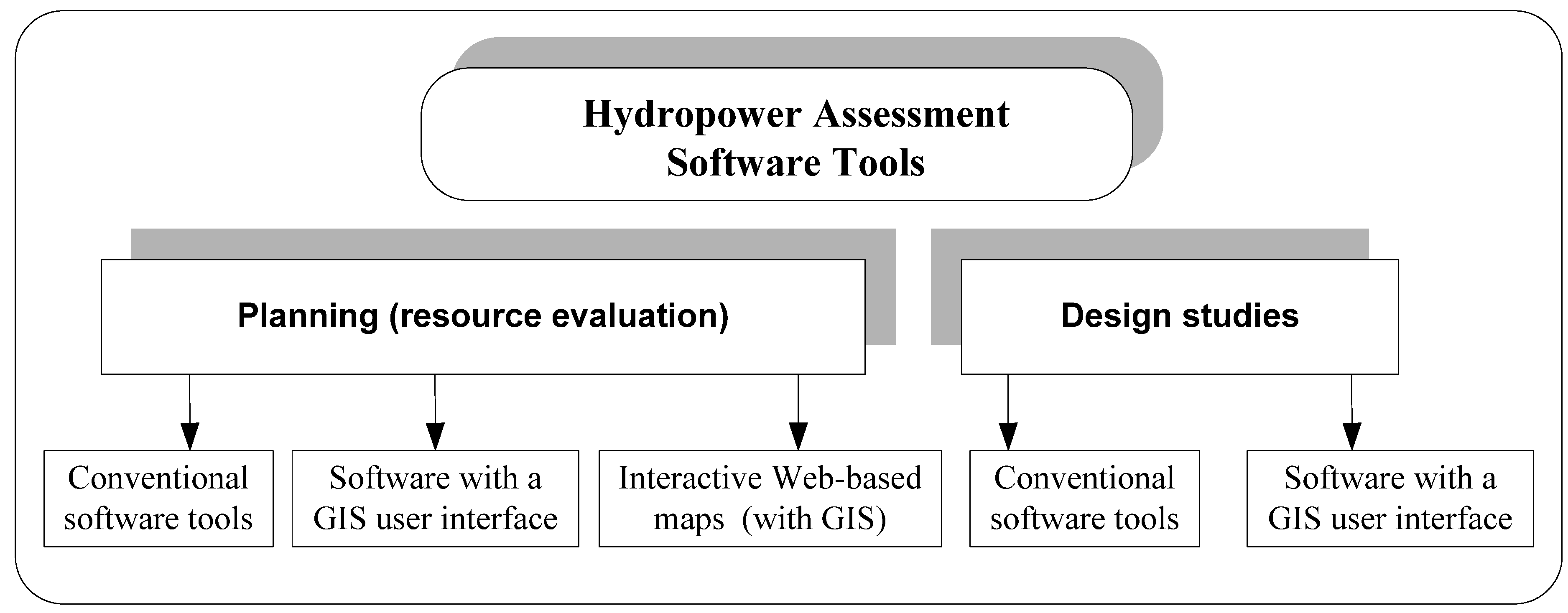
3. Results and Discussion
3.1. Conventional Software Tools for SHP Assessment

| Software Tools | Features | ||||||
|---|---|---|---|---|---|---|---|
| Name | Developer | Applicable countries | Hydrology | Power and energy | Coasting | Economic evaluation | Preliminary design |
| Integrated method for power analysis (IMP) [27] | Natural Resources Canada and POWEL | International | Model | + | − | − | − |
| RETScreen® [29] | Natural Resources Canada | International | FDC | + | + | + | − |
| PEACH [31] | ISL Bureau d’Ingénieurs Conseils, France | International | FDC | + | + | + | + |
| Hydropower Evaluation Software (HES) [33] | Department of Energy, Idaho Engineering and Environmental Laboratory, USA | USA | MAF | − | − | − | − |
| SMART Mini Idro [18] | ERSE SpA, Italy | Italy | FDC | + | + | + | − |
| Hydrohelp [34] | Gordon J.L and OEL-HydroSys, Canada | International | FDC | + | + | + | − |
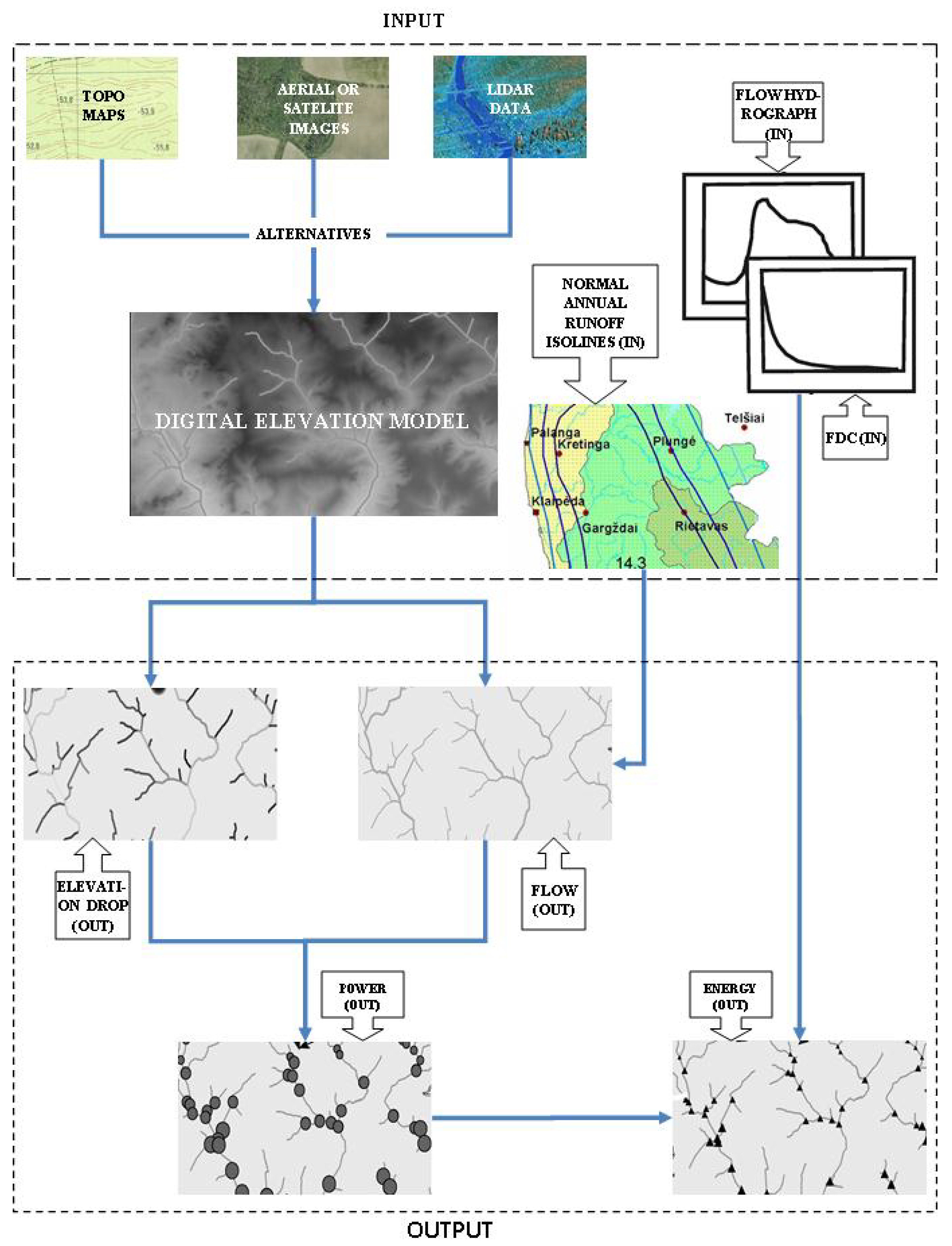
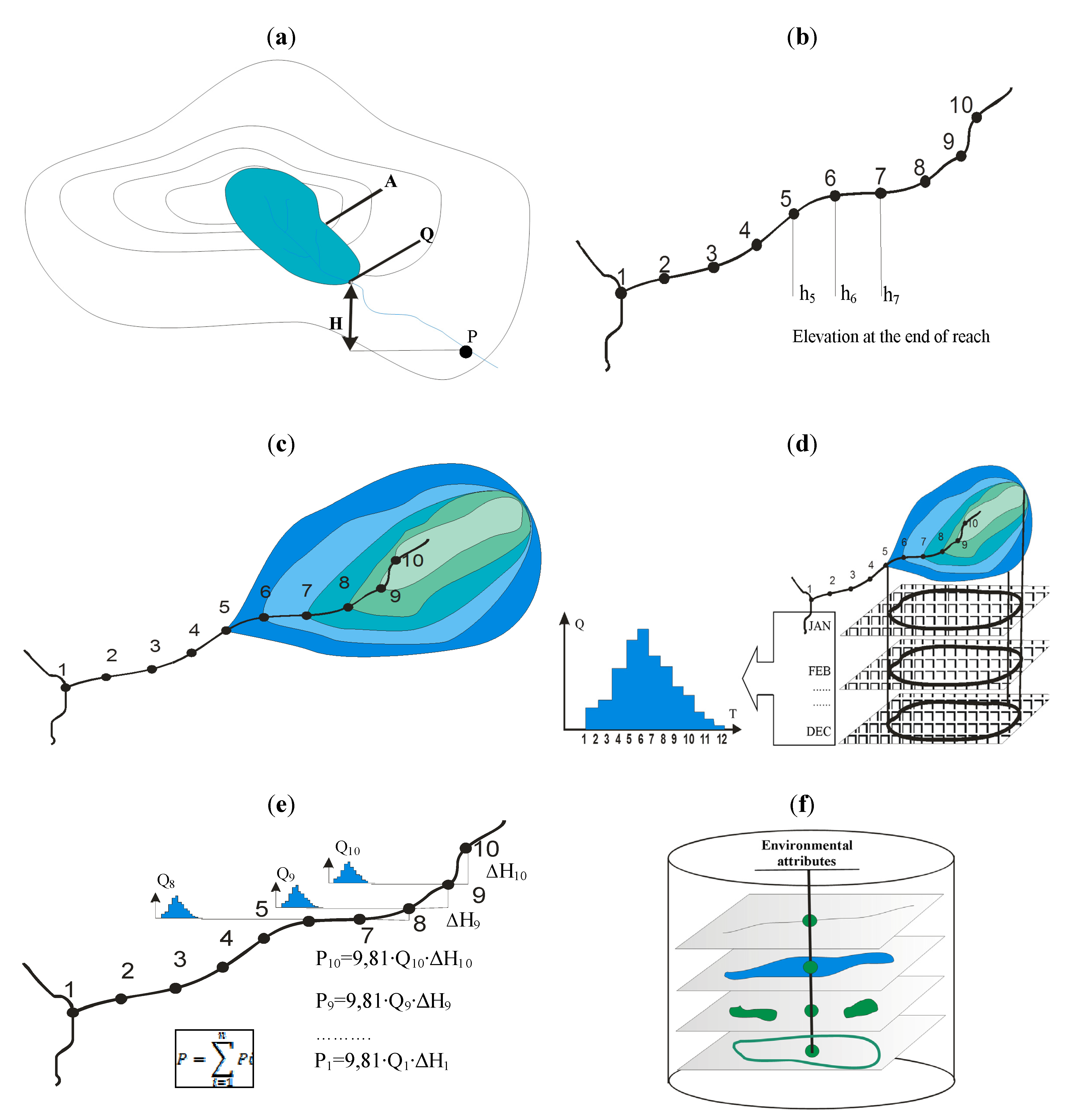
3.2. GIS Applications for Evaluating Hydropower Potential


3.3. Review of Case Studies for SHP Assessment Based on GIS Tools
3.3.1. Canada
| Dataset Data Type | Accuracy | Source | Description |
|---|---|---|---|
| Canadian Digital Elevation Data | DEM/1:250K resolution | Geobase | Continuous representation of surface relief |
| Normal Annual Runoff Isolines | Vector/500 mm contour interval | LRDW | Normal annual depth of runoff |
| BC Watershed Atlas | Vector/based on 1:20K mapping | LRDW/Water Management Branch | Topographic reference for mapped hydrologic features |
| HYDAT Data 2005 | Tabular | Water Survey Canada (WSC) | Daily flow data recorded and archived by WSC for all of Canada. |
| Hydrologic Zones | Vector/1:2M | LRDW | 29 regions of hydrologically similar areas in BC |
3.3.2. France
- Hydrologic and hydrographic characteristics of the basins;
- Rainfall and runoff distribution;
- Characteristics of existing capacities, non-hydroelectric dams, already identified projects, and
- Various types of environmental protection, which could interfere with the development of hydroelectric projects.
3.3.3. Italy
3.3.4. Norway
3.3.5. Scotland
3.3.6. The United States
- GIS tool on the Internet;
- No special software or licenses required for use;
- Displays 500,000 water energy resource sites and 130,000 feasible project sites throughout the U.S.;
- Displays context features needed to perform preliminary feasibility assessments;
- Provides tools for locating and selecting features of interest, and
- Goes beyond geographic location and provides attribute information about selected features.
3.3.7. Concluding Remarks
- Gathering of river basin hydrological characteristics and associated attribute information as spatial GIS data and later using them for broad-based analysis;
- Development of a DEM for the river basin using a variety of primary sources as input data for GIS database development and for later use in the hydropower potential evaluation;
- Development of SHP assessment tools as specialised GIS extensions and integrating them into GIS systems;
- Performance of SHP evaluation and presentation of the results by GIS tools and their interactive use on the Internet.
| SHP Atlas on the Internet | Features | |||||||||
|---|---|---|---|---|---|---|---|---|---|---|
| Name | Developer | Applicable countries | Accessibility | Hydrology | Power and energy | Possible SHP sites | Economic evaluation | Proximity information | SHP renovation | Accounting for other water uses, minimum flow releases |
| NVE Atlas. Potential for SHP plants [47] | Norwegian Water Resources and Energy Directorate (NVE) | Norway | Open access, interactive Web-based maps | MAF | + | + | + | + | − | − |
| Virtual Hydropower Prospector (VHP) [5] | Idaho National Laboratory | US | Open access, interactive Web-based maps | MAF | + | + | + | + | + | − |
| RHAM [40] | Kerr Wood Leidal Associates Ltd (KWL) | British Columbia, Canada | Open access, interactive Web-based maps | MAF/FDC | + | + | + | + | − | + |
| Hydrobot [50] | Nick Forrest Associates Ltd. et al. | Scotland | Limited access | FDC | + | + | + | + | − | + |
| VAPIDRO ASTE [18] | ERSE SpA, | Italy | Open access, interactive Web-based maps | MAF | + | + | + | + | − | + |
4. Conclusions
- During the last 15 years, hydropower assessment tools based on computer software have improved considerably, accounting particularly for the complex integration of river catchment attributes. This improvement is due mainly to the advent of geographic information systems (GIS).
- With recent advances in GIS technology and the increased availability of high-quality topographic and hydrologic data, it is now possible to rapidly assess power potential on a widespread basis while maintaining a relatively high level of detail. In most countries, GIS data are free of charge.
- For hydropower project studies, remote sensing (e.g., LIDAR), which is becoming cost effective compared with conventional surveying, has represented a leap forward in producing digital elevation models, especially in areas that are difficult to access.
- Using DEM and regional hydrologic data, these software tools are able to calculate the amount of hydropower available on all streams in a study area, screening out sites within environmentally sensitive or excluded areas, and to estimate project costs.
- A number of countries (e.g., Canada, Italy, Norway, Scotland and the US) have re-assessed their hydropower capacities based on the spatial information of their water stream catchments, developed tools for automated hydro-site identification and published Web-based GIS tools, the so-called Atlas of small-scale hydropower resources, for open use. Their experience can be applied to other parts of the world to unlock hydropower potential.
- It is absolutely clear that a reliable assessment of real SHP site feasibility implies some “on the ground” surveying, but this traditional assessment can be greatly facilitated with computer programs if the GIS technique involving the spatial variability of catchment characteristics is integrated.
Acknowledgement
References
- Wilson, E.M. Assessment Methods for Small-Hydro Projects; Technical Report; The International Energy Agency: Paris, France, 2000. [Google Scholar]
- International Small Hydro Atlas. Available online: http://www.small-hydro.com/index.cfm?fuseaction=planning.home (accessed on 13 June 2011).
- Punys, P.; Dumbrauskas, A. Advances in hydrological analysis for planning and design of SHP plants. In Proceedings of the International Conference HIDROENERGIA 2010, Lausanne, Switzerland, June 2010.
- Carroll, G.; Rieves, K.; Lee, R.; Cherry, S. Evaluation of potential hydropower sites throughout the United States. In Proceedings of the ESRI International User Conference, San Diego, CA, USA, August 2004.
- Virtual Hydropower Prospector (VHP). Available online: http://hydropower.inel.gov/prospector/index.shtml (accessed on 13 June 2011).
- Jorgensen, J. On trial in Clackamas County. International Water Power & Dam Construction Magazine 2009, 30–33. [Google Scholar]
- United States Geological Survey. In STREAMSTATS. Available online: http://water.usgs.gov/osw/streamstats (accessed on 13 June 2011).
- Larentis, D.G.; Collischonn, W.; Olivera, F.; Tucci, C.E.M. Gis-based procedures for hydropower potential spotting. Energy 2010, 10, 4237–4243. [Google Scholar] [CrossRef]
- Gismalla, Y.A.; Bruen, M. Use of a GIS in reconnaissance studies for small-scale hydropower development in a developing country: a case study from Tanzania. In Proceedings of the Conference HydroGIS 96: Application of Geographic Information Systems in Hydrology and Water Resources Management, Vienna, Austria, April 1996.
- Ballance, A.; Stephenson, D.; Chapman, R.A.; Muller, J.A. Geographic information systems analysis of hydro power potential in South Africa. J. Hydroinform. 2000, 2, 247–254. [Google Scholar]
- Kusrea, B.C.; Baruah, D.C.; Bordoloi, P.K.; Patra, S.C. Assessment of hydropower potential using GIS and hydrological modeling technique in Kopili River basin in Assam (India). Appl. Energy 2010, 1, 298–309. [Google Scholar] [CrossRef]
- Dudhani, S.; Sinha, A.K.; Inamdar, S.S. Assessment of small hydropower potential using remote sensing data for sustainable development in India. Energy Policy 2006, 34, 3195–3205. [Google Scholar] [CrossRef]
- Rojanamon, P.; Chaisomphob, T.; Bureekul, T. Application of geographical information system to site selection of small run-of-river hydropower project by considering engineering/economic/environmental criteria and social impact. Renew. Sustain. Energy Rev. 2009, 13, 2336–2348. [Google Scholar] [CrossRef]
- Deheragoda, C.K.M.; Gunathilaka, J.; Jayantha, H.M.P. Potential of GIS for Promotion of Renewable Energy Power Generation in Sri Lanka with Special Reference to Mini Hydro Projects. Available online: http://mapasia.org/2009/proceeding/utility/index.html (accessed on 12 June 2011).
- Yi, C.-S.; Lee, J.-H.; Shim, M.-P. Site location analysis for small hydropower using geo-spatial information system. Renew. Energy 2010, 35, 852–861. [Google Scholar] [CrossRef]
- Gustard, A.; Irving, K.; Rees, G.; Young, A. Hrological models for small scale hydropower assessment. In Proceedings of the Conference HIDROENERGIA 95, Milan, Italy, September 1995.
- Felix, J. Identifier des sites pour de petits aménagements hydroélectriques. Développement d’un outil SIG. ElectroSuisse Bull. 2010, 3, 44–47. [Google Scholar]
- Strategies to Promote Small Scale Hydro Electricity Production in Europe (S.M.A.R.T.). Available online: http://www.smarthydro.eu/?p=The_Smart_Project (accessed on 13 June 2011).
- Peviani, M.; Alterach, J.; Daneli, A. Uniting European hydropower. International Water Power & Dam Construction Magazine 2010, 28–30. [Google Scholar]
- Monk, R.; Joyce, S.; Homenuke, M. Rapid Hydropower Assessment Model: Identify Hydroelectric Sites Using Geographic Information Systems. In Proceedings of the Small Hydro Conference 2009, Vancouver, Canada, April 2009.
- Forrest, N. Hydrobot: Remote Surveys of National Hydro Resources. In Proceedings of the International Conference HIDROENERGIA 2010, Lausanne, Switzerland, June 2010.
- Alterach, J.; Vergata, M. A method to evaluate the effective potential hydropower production applied to a case study. In Proceedings of the International Conference HIDROENERGIA 2010, Lausanne, Switzerland, June 2010.
- Felix, J.; Dubas, A. Use of GIS to identify potential sites for small hydroelectric plants: general concepts and exemple of application. In Proceedings of the International Conference HIDROENERGIA 2010, Lausanne, Switzerland, June 2010.
- Jia, J.; Punys, P.; Ma, J. Hydropower. In Handbook of Climate Change Mitigation; Chen, W.-Y., Seiner, J., Suzuki, T., Lackner, M., Eds.; Springer Science: New York, NY, USA, 2012; p. 45, in press. [Google Scholar]
- Mozgeris, G.; Punys, P. Lithuanian atlas of small scale hydropower resources. In Proceedings of the Conference Small Hydro-98, Athens, Greece, November 1998.
- Natural resources Canada. User Manual for Integrated Method for Power Analysis (IMP 5.0.); POWEL: Victoria, Canada, 2004. [Google Scholar]
- Integrated method for power analysis (IMP). Available online: http://www.small-hydro.com/index.cfm?fuseaction=planning.imp (accessed on 13 June 2011).
- RETScreen® International; Clean Energy Decision Support Centre. Clean Energy Project Analysis: RETSCREEN® Engineering & Cases Textbook. Small Hydro Project Analysis Chapter; Natural Resources Canada: Ottawa, Canada, 2004. [Google Scholar]
- RETScreen®. Available online: http://www.retscreen.net/ (accessed on 13 June 2011).
- Deroo, L.; van Hecke, N.; Isambert, F. Le logiciel Peach, un outil de valorisation des petits aménagements hydroélectriques. Houille Blanche 1999, 1, 19–26. [Google Scholar] [CrossRef]
- PEACH. Available online: http://www.isl.fr/refpages/fr/pages/refa5r1.htm (accessed on 13 June 2011).
- Francfort, J.E.; Matthews, S.D.; Rinehart, B.N. Uniform Criteria for U.S. Hydropower Resource Assessment. Hydropower Evaluation Software (HES) User’s Manual; Department of Energy Idaho Operations Office: Idaho Falls, ID, USA, 2002. [Google Scholar]
- Hydropower Evaluation Software (HES). Available online: http://hydropower.inel.gov/resourceassessment/software/ (accessed on 13 June 2011).
- OEL HYDROSYS. HydroHelp Series of Hydro Design and Cost Programs—a Description with Examples of Program Screens, Canada. 2008. Available online: http://hydrohelp.ca/eng/home.htm (accessed on 13 June 2011).
- Burrough, P.A.; Mcdonnell, R.A. Principles of Geographical Information Systems, 2nd ed.; Oxford University Press: Oxford, UK, 1998; p. 327. [Google Scholar]
- Verner, J.S. User experience with the Hydrohelp programs. In Proceedings of the Small Hydro Conference 2009, Vancouver, BC, Canada, April 2009.
- Maidment, D.R. ArcHydro: GIS for Water Resources; ESRI Press: Redlands, CA, USA, 2002; p. 220. [Google Scholar]
- Maidment, D.R.; Djokic, D. Hydrologic and Hydraulic Modeling Support with Geographic Information Systems; ESRI Press: Redlands, CA, USA, 2000; p. 232. [Google Scholar]
- Kerr Wood Leidal Associates Ltd. (KWL). Run-of-River Hydroelectric Resource Assessment for British Columbia; Final Report; BC Hydro, BC Transmission Corporation: Vancouver, BC, Canada, 2007. [Google Scholar]
- Kerr Wood Leidal Associates Limited. Rapid Hydro Assessment Model (RHAM). Available online: http://www.rapidhydro.ca/ (accessed on 13 June 2011).
- Crépon, O. Re-assessing French hydropower potential. Int. J. Hydropower Dams 2009, 5, 47–49. [Google Scholar]
- Alterach, J.; Lterach, J.; Pevani, M.; Davitti, A.; Vergata, M.; Ciaccia, G.; Fontini, F. Evaluation of the remaining hydro potential in Italy. Int. J. Hydropower Dams 2009, 5, 56–59. [Google Scholar]
- Jensen, T. Estimation of the Potential for Small Power Plants in Norway; Report No. 19; Norwegian Water Resources and Energy Directorate: Oslo, Norway, 2004. [Google Scholar]
- Jensen, T. Building Small Hydro in Norway. HRW 2008, 4, 20–27. [Google Scholar]
- Voksø, A. Using GIS to calculate potential for small hydro power plants in Norway. In Proceedings of the XXV Nordic Hydrological Conference, Nordic Association for Hydrology, Reykjavik, Iceland, August 2008.
- Lytskjold, B. Geographical Information System (GIS) at NVE; NVE, Geoinformation Section: Oslo, Norway, November 2009. Available online: http://www.nve.no/PageFiles/8427/GIS%20in%20Hydrology%2019Nov09.pdf (accessed on 13 June 2011).
- NVE Atlas: Potential Sites for Small Hydropower. Available online: http://arcus.nve.no/website/potensial_smaakrv/viewer.htm (accessed on 13 June 2011).
- Forrest, N. Getting to the bottom of it—identifying hydro sites. International Water Power & Dam Construction Magazine 2009, 42–44. [Google Scholar]
- Scottish Hydropower Resource Study; Final Report to the Scottish Government through the Hydro Sub Group (FHSG) Nick Forrest Associates Ltd.; Scottish Institute of Sustainable Technology (SISTech) and Black & Veatch Ltd.: Edinburgh, UK, 2008.
- Hydrobot. Available online: http://www.nickforrestassoc.co.uk/tilemap.php (accessed on 13 June 2011).
- Hall, D.G.; White, S.E.; Brizzee, J.A.; Lee, R.D. User’s Guide. Virtual Hydropower Prospector; Version 1.1; Idaho National Laboratory: Idaho Falls, ID, USA, 2005. [Google Scholar]
© 2011 by the authors; licensee MDPI, Basel, Switzerland. This article is an open access article distributed under the terms and conditions of the Creative Commons Attribution license (http://creativecommons.org/licenses/by/3.0/).
Share and Cite
Punys, P.; Dumbrauskas, A.; Kvaraciejus, A.; Vyciene, G. Tools for Small Hydropower Plant Resource Planning and Development: A Review of Technology and Applications. Energies 2011, 4, 1258-1277. https://doi.org/10.3390/en4091258
Punys P, Dumbrauskas A, Kvaraciejus A, Vyciene G. Tools for Small Hydropower Plant Resource Planning and Development: A Review of Technology and Applications. Energies. 2011; 4(9):1258-1277. https://doi.org/10.3390/en4091258
Chicago/Turabian StylePunys, Petras, Antanas Dumbrauskas, Algis Kvaraciejus, and Gitana Vyciene. 2011. "Tools for Small Hydropower Plant Resource Planning and Development: A Review of Technology and Applications" Energies 4, no. 9: 1258-1277. https://doi.org/10.3390/en4091258
APA StylePunys, P., Dumbrauskas, A., Kvaraciejus, A., & Vyciene, G. (2011). Tools for Small Hydropower Plant Resource Planning and Development: A Review of Technology and Applications. Energies, 4(9), 1258-1277. https://doi.org/10.3390/en4091258