Spatial Site Selection for Solar Power Plants Using a GIS-Based Boolean-Fuzzy Logic Model: A Case Study of Markazi Province, Iran
Abstract
1. Introduction
2. Materials and Methods
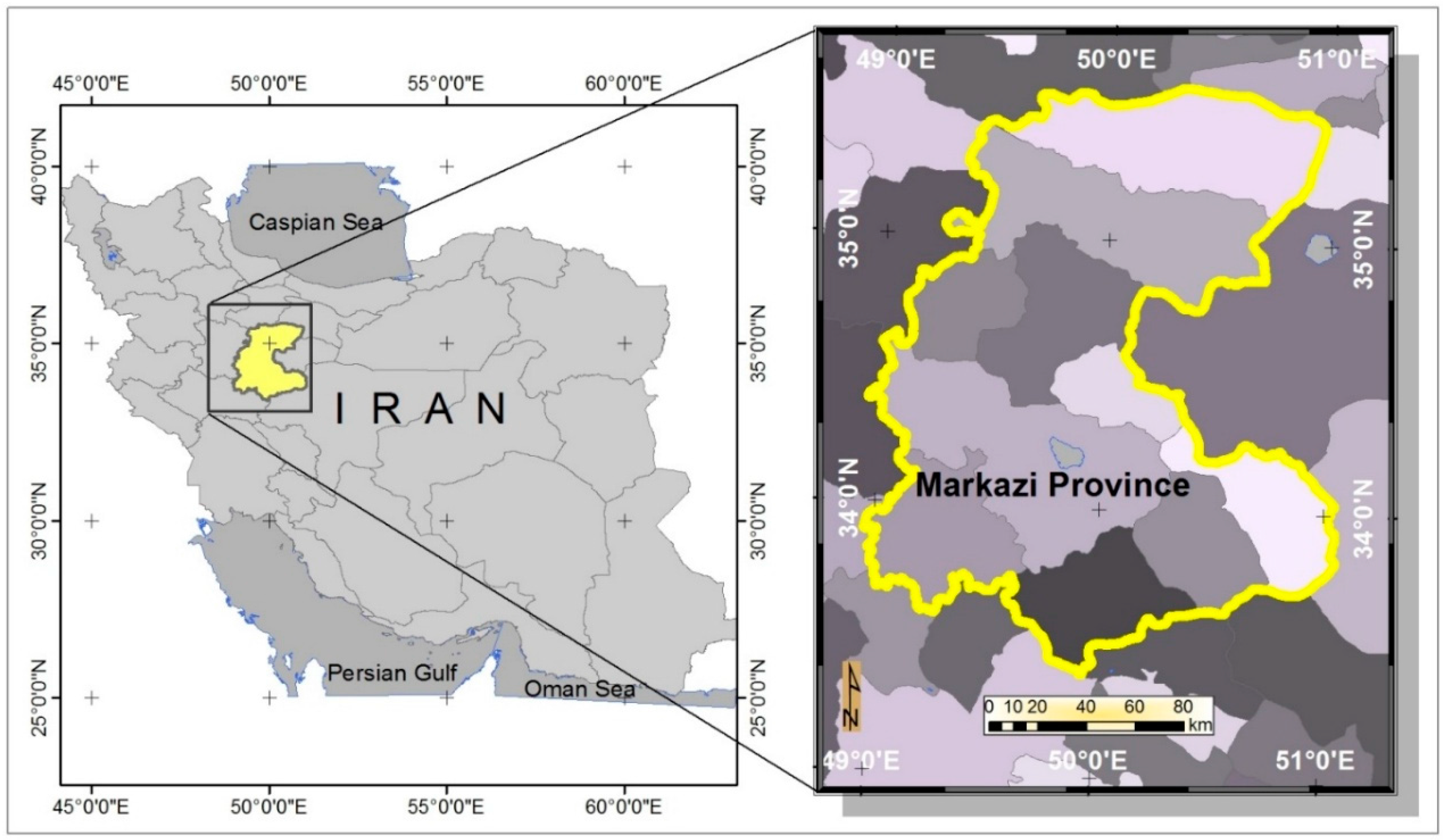
2.1. Case Study
2.2. Criteria Selection and Data Acquisition
2.2.1. Economic Criteria
2.2.2. Environmental Criteria
2.2.3. Technical Criteria
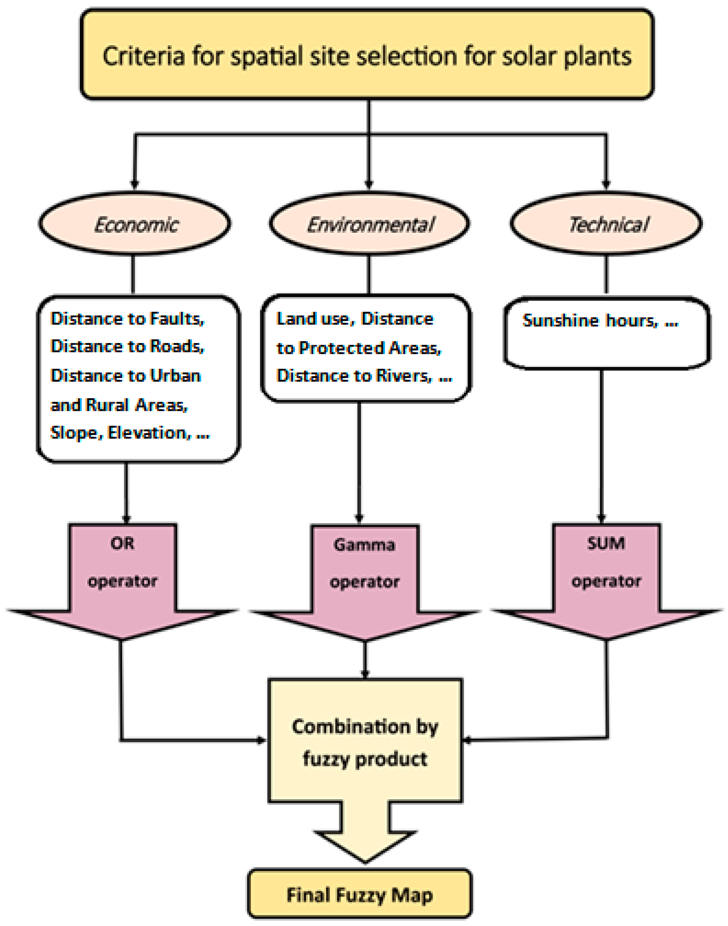
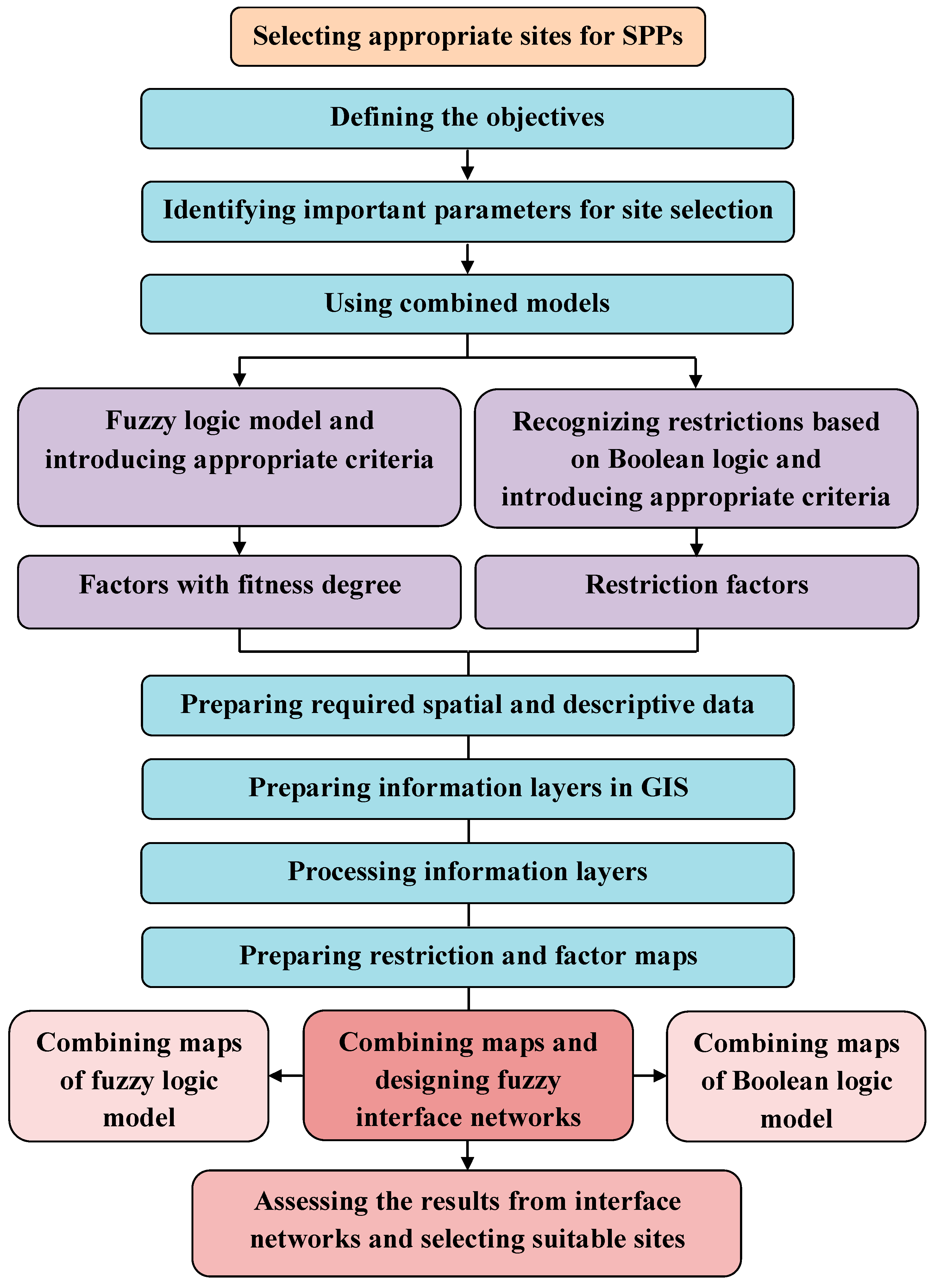
2.3. Conceptual Framework
3. Data Processing
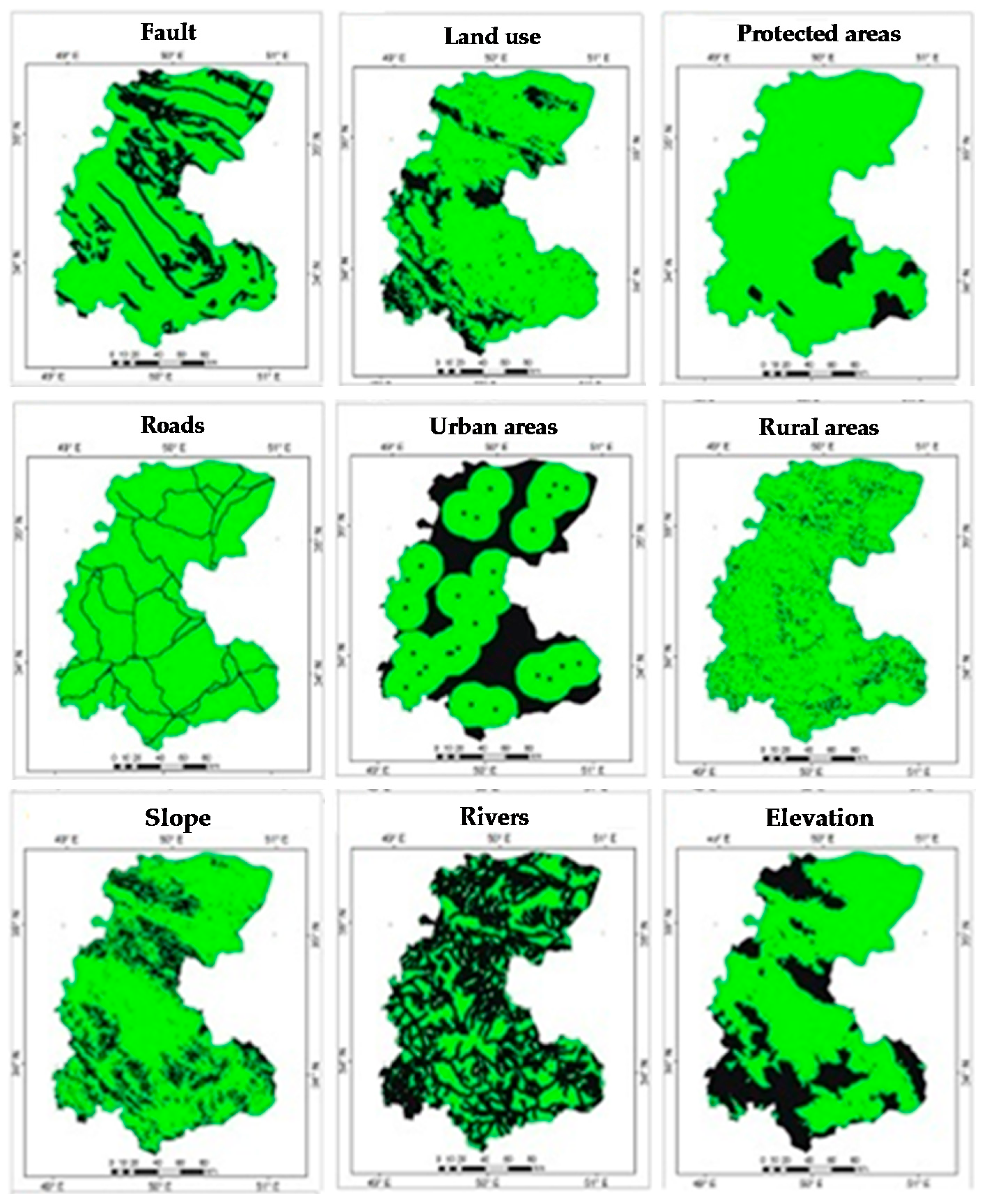
3.1. Generation of Boolean Maps
3.2. Generation of Fuzzy Maps
4. Data Integration and Analysis
5. Results and Discussion
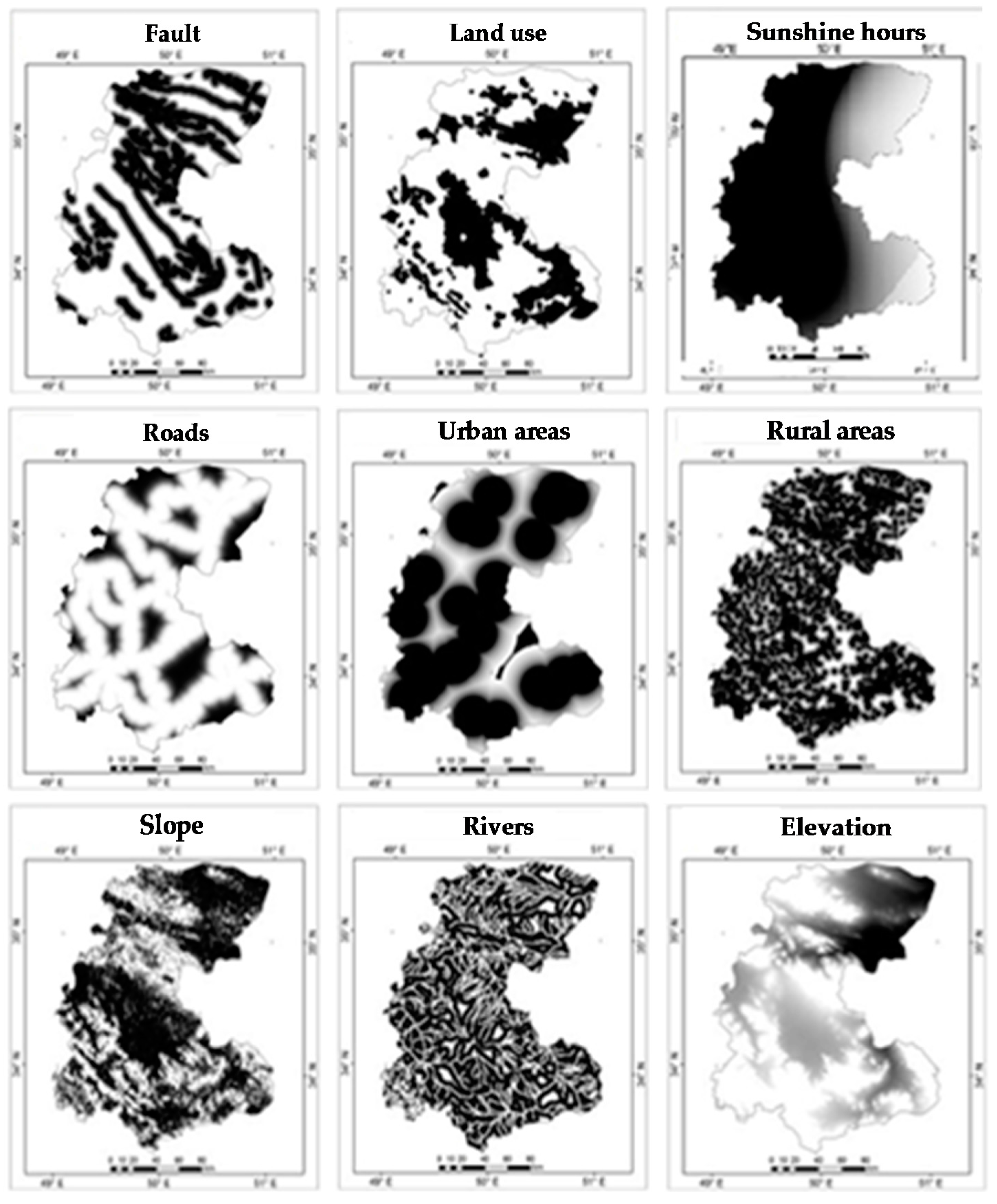
5.1. Boolean and Fuzzy Results
5.1.1. Distance to Faults
5.1.2. Distance to Roads
5.1.3. Distance to Urban and Rural Areas
5.1.4. Slope
5.1.5. Elevation
5.1.6. Land Use
5.1.7. Distance to Protected Areas
5.1.8. Distance to Rivers
5.1.9. Sunshine Hours
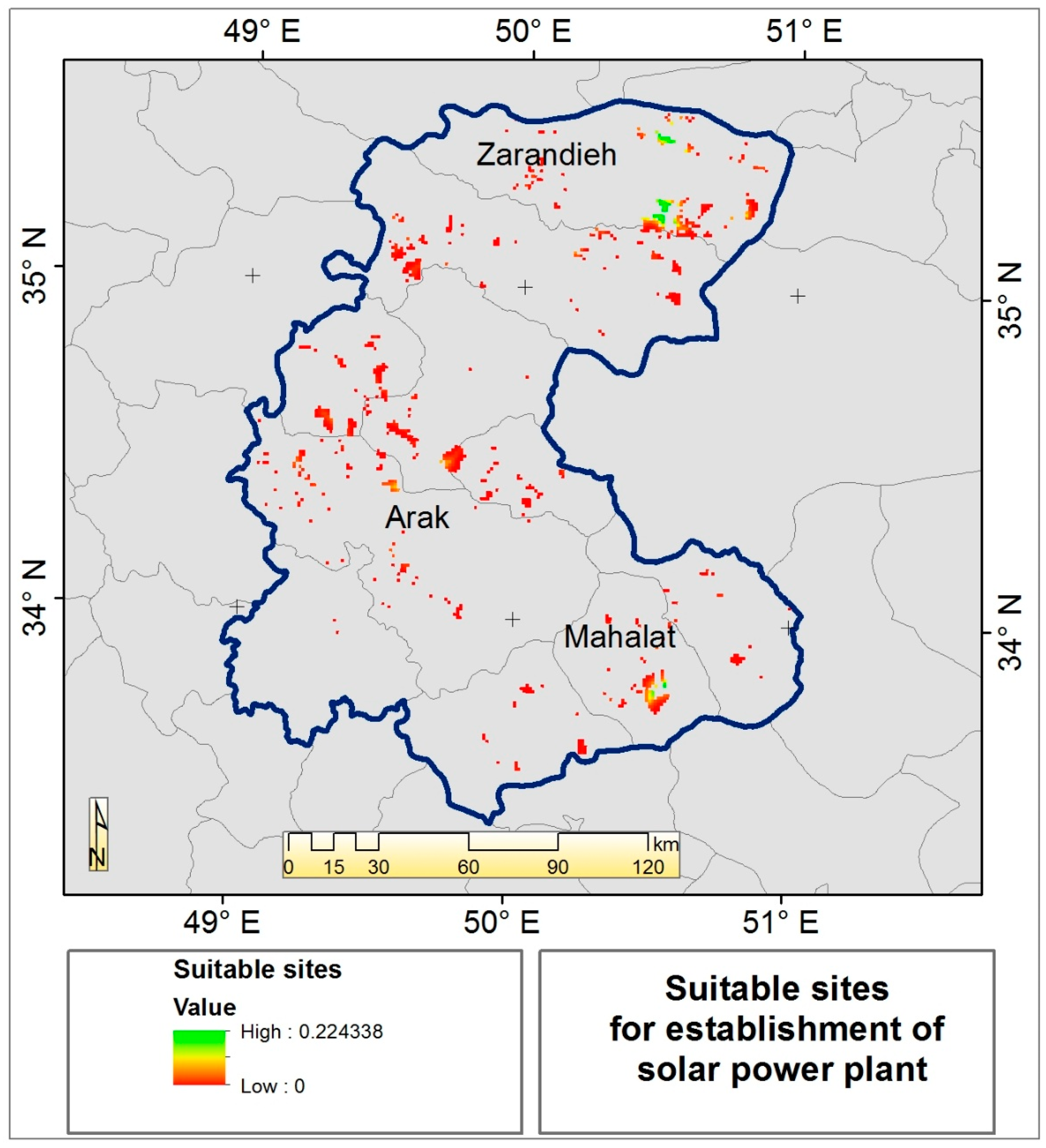
5.2. Boolean-Fuzzy Integration
6. Conclusions
Author Contributions
Conflicts of Interest
References
- Solangi, K.H.; Islam, M.R.; Saidur, R.; Rahim, N.A.; Fayaz, H. A review on global solar energy policy. Renew. Sustain. Energy Rev. 2011, 15, 2149–2163. [Google Scholar] [CrossRef]
- Devabhaktuni, V.; Alam, M.; Depuru, S.S.R.; Green, R.C., II; Nims, D.; Near, C. Solar energy: Trends and enabling technologies. Renew. Sustain. Energy Rev. 2013, 19, 555–564. [Google Scholar] [CrossRef]
- Hosenuzzaman, M.; Rahim, N.A.; Selvaraj, J.; Hasanuzzaman, M.; Malek, A.B.M.A.; Nahar, A. Global prospects, progress, policies, and environmental impact of solar photovoltaic power generation. Renew. Sustain. Energy Rev. 2015, 41, 284–297. [Google Scholar] [CrossRef]
- Burkart, K. How Much CO2 Does One Solar Panel Create? Available online: http://www.mnn.com/green-tech/research-innovations/blogs/how-much-co2-doesone-solar-panel-create/ (accessed on 10 May 2016).
- Joshi, A.S.; Tiwari, A.; Tiwari, G.N.; Dincer, I.; Reddy, B.V. Performance evaluation of a hybrid photovoltaic thermal (PV/T) (glass-to-glass) system. Int. J. Therm. Sci. 2009, 48, 154–164. [Google Scholar] [CrossRef]
- Kimball, J.W.; Kuhn, B.T.; Balog, R.S. A system design approach for unattended solar energy harvesting supply. IEEE Trans. Power Electron. 2009, 24, 952–962. [Google Scholar] [CrossRef]
- Wang, X.; Zhao, L.; Wang, J.; Zhang, W.; Zhao, X.; Wu, W. Performance evaluation of a low-temperature solar Rankine cycle system utilizing R245fa. Sol. Energy 2010, 84, 353–364. [Google Scholar] [CrossRef]
- Zhou, W.; Lou, C.; Li, Z.; Lu, L.; Yang, H. Current status of research on optimum sizing of stand-alone hybrid solar-wind power generation systems. Appl. Energy 2010, 87, 380–389. [Google Scholar] [CrossRef]
- Coskun, C.; Oktay, Z.; Dincer, I. Estimation of monthly solar radiation distribution for solar energy system analysis. Energy 2011, 36, 1319–1323. [Google Scholar] [CrossRef]
- Chong, W.T.; Naghavi, M.S.; Poh, S.C.; Mahlia, T.M.I.; Pan, K.C. Techno-economic analysis of a wind-solar hybrid renewable energy system with rainwater collection feature for urban high-rise application. Appl. Energy 2011, 88, 4067–4077. [Google Scholar] [CrossRef]
- Yumrutas, R.; Ünsal, M. Energy analysis and modeling of a solar assisted house heating system with a heat pump and an underground energy storage tank. Sol. Energy 2012, 86, 983–993. [Google Scholar] [CrossRef]
- Pillot, B.; Muselli, M.; Poggi, P.; Haurant, P.; Hared, I. Solar energy potential atlas for planning energy system off-grid electrification in the Republic of Djibouti. Energy Convers. Manag. 2013, 69, 131–147. [Google Scholar] [CrossRef]
- Ahmadi, P.; Dincer, I.; Rosen, M.A. Multi-objective optimization of a novel solar-based multigeneration energy system. Sol. Energy 2014, 108, 576–591. [Google Scholar] [CrossRef]
- Acton, N.; Bernazani, M.; Hill, J.; Hinton, M.; Vazquez, A.; Gipson, K.; Nagel, J. Design of a Climate Adaptable Solar Energy system using biomimetic inspiration from a lichen symbiosis. In Proceedings of the IEEE Systems and Information Engineering Design Symposium (SIEDS), Charlottesville, VA, USA, 25 April 2014; pp. 177–182. [Google Scholar]
- El-Damak, D.; Chandrakasan, A.P. Solar energy harvesting system with integrated battery management and startup using single inductor and 3.2 nW quiescent power. In Proceedings of the IEEE Symposium on VLSI Circuits (VLSI Circuits), Kyoto, Japan, 17–19 June 2015; pp. C280–C281. [Google Scholar]
- Bayrak, Z.U.; Bayrak, G.; Ozdemir, M.T.; Gencoglu, M.T.; Cebeci, M. A low-cost power management system design for residential hydrogen & solar energy based power plants. Int. J. Hydrog. Energy 2016, 41, 12569–12581. [Google Scholar]
- Xia, X.; Xia, J. Evaluation of potential for developing renewable sources of energy to facilitate development in developing countries. In Proceedings of the Asia-Pacific Power and Energy Engineering Conference, Chengdu, China, 28–31 March 2010; pp. 1–3. [Google Scholar]
- Angelis-Dimakis, A.; Biberacher, M.; Dominguez, J.; Fiorese, G.; Gadocha, S.; Gnansounou, E.; Guariso, G.; Kartalidis, A.; Panichelli, L.; Pinedo, I.; et al. Methods and tools to evaluate the availability of renewable energy sources. Renew. Sustain. Energy Rev. 2011, 15, 1182–1200. [Google Scholar] [CrossRef]
- Frankfort School, FS-UNEP Collaborating Centre for Climate and Sustainable Energy Finance. Global Trends in Renewable Energy Investment. Available online: http://fs-unep-centre.org/sites/default/files/publications/globaltrendsinrenewableenergyinvestment2016lowres_0.pdf (accessed on 15 January 2018).
- Johnston, I. Developing World Invests More in Renewable Energy than Rich Countries For First Time, New Study Says. Available online: http://www.independent.co.uk/environment/climate-change/renewable-energy-investment-developed-world-developing-world-ren21-report-a7058436.html (accessed on 10 May 2016).
- Intergovernmental Panel on Climate Change (IPCC). Special Report on Renewable Energy Sources and Climate Change Mitigation; Cambridge University Press: Cambridge, UK; New York, NY, USA, 2011. [Google Scholar]
- Graebig, M.; Bringezu, S.; Fenner, R. Comparative Analysis of Environmental Impacts of Maize-Biogas and Photovoltaics on a Land Use Basis. Sol. Energy 2010, 84, 1255–1263. [Google Scholar] [CrossRef]
- Turney, D.; Fthenakis, V. Environmental impacts from the installation and operation of large-scale solar power plants. Renew. Sustain. Energy Rev. 2011, 15, 3261–3270. [Google Scholar] [CrossRef]
- Perpiña Castillo, C.; Batista e Silva, F.; Lavalle, C. An assessment of the regional potential for solar power generation in EU-28. Energy Policy 2016, 88, 86–99. [Google Scholar] [CrossRef]
- Aydin, N.Y.; Kentel, E.; SebnemDuzgun, H. GIS-based site selection methodology for hybrid renewable energy systems: A case study from western Turkey. Energy Convers. Manag. 2013, 70, 90–106. [Google Scholar] [CrossRef]
- Massimo, A.; Dell’Isola, M.; Frattolillo, A.; Ficco, G. Development of a Geographical Information System (GIS) for the integration of solar energy in the energy planning of a wide area. Sustainability 2014, 6, 5730–5744. [Google Scholar] [CrossRef]
- De Simón-Martín, M.; Diez-Suárez, A.-M.; Álvarez-de Prado, L.; González-Martínez, A.; de la Puente-Gil, Á.; Blanes-Peiró, J. Development of a GIS Tool for High Precision PV Degradation Monitoring and Supervision: Feasibility Analysis in Large and Small PV Plants. Sustainability 2017, 9, 965. [Google Scholar] [CrossRef]
- Huld, T.; Moner-Girona, M.; Kriston, A. Geospatial Analysis of Photovoltaic Mini-Grid System Performance. Energies 2017, 10, 218. [Google Scholar] [CrossRef]
- Carrion, J.A.; Estrella, A.E.; Dols, F.A.; Ridao, A.R. The Electricity Production Capacity of Photovoltaic Power Plants and the Selection of Solar Energy Sites in Andalusia (Spain). Renew. Energy 2008, 33, 545–552. [Google Scholar] [CrossRef]
- Hofierka, J.; Kaňuk, J. Assessment of photovoltaic potential in urban areas using open-source solar radiation tools. Renew. Energy 2009, 34, 2206–2214. [Google Scholar] [CrossRef]
- Janke, J.R. Multicriteria GIS modeling of wind and solar farms in Colorado. Renew. Energy 2010, 35, 2228–2234. [Google Scholar] [CrossRef]
- Aragonés-Beltrán, P.; Chaparro-González, F.; Pastor-Ferrando, J.P.; Rodríguez-Pozo, F. An ANP-based approach for the selection of photovoltaic solar power plant investment projects. Renew. Sustain. Energy Rev. 2010, 14, 249–264. [Google Scholar] [CrossRef]
- Charabi, Y.; Gastli, A. PV site suitability analysis using GIS-based spatial fuzzy multi-criteria evaluation. Renew. Energy 2011, 36, 2554–2561. [Google Scholar] [CrossRef]
- Sánchez-Lozano, J.M.; Teruel-Solano, J.; Soto-Elvira, P.L.; Socorro García-Cascales, M. Geographical Information Systems (GIS) and Multi-Criteria Decision Making (MCDM) methods for the evaluation of solar farms locations: Case study in south-eastern Spain. Renew. Sustain. Energy Rev. 2013, 24, 544–556. [Google Scholar] [CrossRef]
- Uyan, M. GIS-based solar farms site selection using analytic hierarchy process (AHP) in Karapinar region Konya/Turkey. Renew. Sustain. Energy Rev. 2013, 28, 11–17. [Google Scholar] [CrossRef]
- Yousefi-Sahzabi, A.; Sasaki, K.; Yousefi, H. Some Thoughts on the Notion of Environmental Information Science. Electron. Green J. 2014, 1, 1–16. [Google Scholar]
- Yousefi, H.; Noorollahi, Y.; Hajinezhad, A.; Alimohammadi, A. GIS-based spatially integrated bioenergy resources assessment in Kurdistan Province-Northwest Iran. Sustain. Energy Technol. Assess. 2017, 23, 11–20. [Google Scholar] [CrossRef]
- Noorollahi, Y.; Yousefi, H.; Mohammadi, M. Multi-criteria decision support system for wind farm site selection using GIS. Sustain. Energy Technol. Assess. 2016, 13, 38–50. [Google Scholar] [CrossRef]
- Yousefi-Sahzabi, A.; Sasaki, K.; Yousefi, H.; Pirasteh, S.; Sugai, Y. GIS aided prediction of CO2 emission dispersion from geothermal electricity production. J. Clean. Prod. 2011, 19, 982–1993. [Google Scholar] [CrossRef]
- Yousefi-Sahzabi, A.; Sasaki, K.; Djamaluddin, I.; Yousefi, H.; Sugai, Y. GIS modeling of CO2 emission sources and storage possibilities. Energy Procedia 2011, 4, 2831–2838. [Google Scholar] [CrossRef]
- Yousefi, H.; Zahedi, S.; Niksokhan, M.H. Modifying the analysis made by water quality index using multi-criteria decision making methods. J. Afr. Ear. Sci. 2018, 138, 309–318. [Google Scholar] [CrossRef]
- Yousefi, H.; Yousefi-Sahzabi, A.; Masih, M.; Ghaleh, S.; Mirzaaghabeik, M. Urban Parks Prioritization Concerning the Age-friendly Criteria in Sari, Northern Iran. Int. J. Occup. Hyg. 2017, 8, 116–123. [Google Scholar]
- Yousefi, H.; Javadzadeh, Z.; Noorollahi, Y.; Yousefi-Sahzabi, A. Landfill Site Selection Using a Multi-Criteria Decision-Making Method: A Case Study of the Salafcheghan Special Economic Zone, Iran. Sustainability 2018, 10, 1107. [Google Scholar] [CrossRef]
- Lewis, S.M.; Gross, S.; Visel, A.; Kelly, M.; Morrow, W. Fuzzy gis-based multi-criteria evaluation for us agave production as a bioenergy feedstock. GCB Bioenergy 2015, 7, 84–99. [Google Scholar] [CrossRef]
- Hermann, B.G.; Kroeze, C.; Jawjit, W. Assessing environmental performance by combining life cycle assessment, multi-criteria analysis and environmental performance indicators. J. Clean. Prod. 2007, 15, 1787–1796. [Google Scholar] [CrossRef]
- Aragonés-Beltrán, P.; Chaparro-González, F.; Pastor-Ferrando, J.P.; Pla-Rubio, A. An AHP (Analytic Hierarchy Process)/ANP (Analytic Network Process)-based multi-criteria decision approach for the selection of solar-thermal power plant investment projects. Energy 2014, 66, 222–238. [Google Scholar] [CrossRef]
- Sánchez-Lozano, J.M.; Henggeler Antunes, C.; García-Cascales, M.S.; Dias, L.C. GIS-based photovoltaic solar farms site selection using ELECTRE-TRI: Evaluating the case for Torre Pacheco, Murcia, Southeast of Spain. Renew. Energy 2014, 66, 478–494. [Google Scholar] [CrossRef]
- Zoghi, M.; Ehsani, A.H.; Sadat, M.; Javad Amiri, M.; Karimi, S. Optimization solar site selection by fuzzy logic model and weighted linear combination method in arid and semi-arid region: A case study Isfahan-IRAN. Renew. Sustain. Energy Rev. 2015, 68, 986–996. [Google Scholar] [CrossRef]
- Saaty, T.L. The Analytic Hierarchy Process; McGraw-Hill International: New York, NY, USA, 1980. [Google Scholar]
- Ali, S.; Lee, S.-M.; Jang, C.-M. Determination of the Most Optimal On-Shore Wind Farm Site Location Using a GIS-MCDM Methodology: Evaluating the Case of South Korea. Energies 2017, 10, 2072. [Google Scholar] [CrossRef]
- Saaty, T.L. Theory and Applications of the Analytic Network Process: Decision Making with Benefits, Opportunities, Costs, and Risks; RWS Publications: Pittsburgh, PA, USA, 2005. [Google Scholar]
- Sun, H.; Cheng, X.; Dai, M. Regional flood disaster resilience evaluation based on analytic network process: A case study of the Chaohu Lake Basin, Anhui Province, China. Nat. Hazards 2016, 82, 39–58. [Google Scholar] [CrossRef]
- Cheng, C.; Thompson, R.G. Application of boolean logic and gis for determining suitable locations for temporary disaster waste management sites. Int. J. Disaster Risk Reduct. 2016, 20, 78–92. [Google Scholar] [CrossRef]
- Jiang, H.; Eastman, J.R. Application of fuzzy measures in multi-criteria evaluation in GIS. Int. J. Geogr. Inf. Sci. 2000, 14, 173–184. [Google Scholar] [CrossRef]
- Zadeh, L.A. Fuzzy sets. Inf. Control 1965, 8, 338–353. [Google Scholar] [CrossRef]
- Hall, G.B.; Wang, F.; Subaryono. Comparison of Boolean and fuzzy classification methods in land suitability analysis by using geographical information systems. Environ. Plan. A 1992, 24, 497–516. [Google Scholar] [CrossRef]
- Khorasanizadeh, H.; Mohammadi, K. Prediction of daily global solar radiation by day of the year in four cities located in the sunny regions of Iran. Energy Convers. Manag. 2013, 76, 385–392. [Google Scholar] [CrossRef]
- Besarati, S.M.; Padilla, R.V.; Goswami, D.Y.; Stefanakos, E. The potential of harnessing solar radiation in Iran: Generating solar maps and viability study of PV power plants. Renew. Energy 2013, 53, 193–199. [Google Scholar] [CrossRef]
- Alamdari, P.; Nematollahi, O.; Alemrajabi, A.A. Solar energy potentials in Iran: A review. Renew. Sustain. Energy Rev. 2013, 21, 778–788. [Google Scholar] [CrossRef]
- Little, S. A Delphi Study on Risk and Uncertainty Decision Making for Renewable Energy Green Supply Chain Management. Ph.D. Thesis, Northcentral University, Scottsdale, AZ, USA, 2017. [Google Scholar]
- Lingga, M.M. Developing a Hierarchical Decision Model to Evaluate Nuclear Power Plant Alternative Siting Technologies. Ph.D. Thesis, Portland State University, Portland, OH, USA, 2016. [Google Scholar]
- Şener, S.; Şener, E.; Nas, B.; Karagüzel, R. Combining AHP with GIS for landfill site selection: A case study in the Lake Beyşehir catchment area (Konya, Turkey). Waste Manag. 2010, 30, 2037–2046. [Google Scholar] [CrossRef] [PubMed]
- Charabi, Y.; Gastli, A. Integration of temperature and dust effects in siting large PV power plant in hot arid area. Renew. Energy 2013, 57, 635–644. [Google Scholar] [CrossRef]
- Barakat, A.; Hilali, A.; El Baghdadi, M.; Touhami, F. Landfill site selection with GIS-based multi-criteria evaluation technique. A case study in Béni Mellal-Khouribga Region, Morocco. Environ. Earth Sci. 2017, 76, 413. [Google Scholar] [CrossRef]
- Shahabi, H.; Keihanfard, S.; Bin Ahmad, B.; Amiri, M.J.T. Evaluating boolean, AHP and WLC methods for the selection of waste landfill sites using GIS and satellite images. Environ. Earth Sci. 2014, 71, 4221–4233. [Google Scholar] [CrossRef]
- Zaidi, F.K.; Nazzal, Y.; Ahmed, I.; Naeem, M.; Jafri, M.K. Identification of potential artificial groundwater recharge zones in Northwestern Saudi Arabia using GIS and Boolean logic. J. Afr. Ear. Sci. 2015, 111, 156–169. [Google Scholar] [CrossRef]
- Makhdoom, M.; Darvish Sefat, A.A.; Jafar Zadeh, H.; Makhdoom, A. Environmental Assessment and Planning with GIS; Tehran University Publication: Tehran, Iran, 2007. [Google Scholar]
- Atici, K.B.; Simsek, A.B.; Ulucan, A.; Tosun, M.U. A GIS-based Multiple Criteria Decision Analysis approach for wind power plant site selection. Util. Policy 2015, 37, 86–96. [Google Scholar] [CrossRef]
- Asakereh, A.; Omid, M.; Alimardani, R.; Sarmadian, F. Developing a GIS-based fuzzy AHP model for selecting solar energy sites in Shodirwan region in Iran. Int. J. Adv. Sci. Technol. 2014, 68, 37–48. [Google Scholar] [CrossRef]
- Ma, J.; Scott, N.R.; DeGloria, S.D.; Lembo, A.J. Siting analysis of farm-based centralized anaerobic digester systems for distributed generation using GIS. Biomass Bioenergy 2005, 28, 591–600. [Google Scholar] [CrossRef]
- Bunruamkaew, K.; Murayama, Y. Site suitability evaluation for ecotourism using GIS & AHP: A case study of Surat Thani province, Thailand. Procedia Soc. Behav. Sci. 2011, 21, 269–278. [Google Scholar]
- Hafeznia, H.; Yousefi, H.; Astaraei, F.R. A novel framework for the potential assessment of utility-scale photovoltaic solar energy, application to eastern Iran. Energy Convers. Manag. 2017, 151, 240–258. [Google Scholar] [CrossRef]
- Kahraman, C.; Kaya, İ.; Cebi, S. A comparative analysis for multiattribute selection among renewable energy alternatives using fuzzy axiomatic design and fuzzy analytic hierarchy process. Energy 2009, 34, 1603–1616. [Google Scholar] [CrossRef]
- Tahri, M.; Hakdaoui, M.; Maanan, M. The evaluation of solar farm locations applying geographic information system and multi-criteria decision-making methods: Case study in southern Morocco. Renew. Sustain. Energy Rev. 2015, 51, 1354–1362. [Google Scholar] [CrossRef]
- Brewer, J.; Ames, D.P.; Solan, D.; Lee, R.; Carlisle, J. Using GIS analytics and social preference data to evaluate utility-scale solar power site suitability. Renew. Energy 2015, 81, 825–836. [Google Scholar] [CrossRef]
- Carrión, J.A.; Estrella, A.E.; Dols, F.A.; Toro, M.Z.; Rodríguez, M.; Ridao, A.R. Environmental decision-support systems for evaluating the carrying capacity of land areas: Optimal site selection for grid-connected photovoltaic power plants. Renew. Sustain. Energy Rev. 2008, 9, 2358–2380. [Google Scholar] [CrossRef]
- Lungu, I.; Velicanu, A.; Bara, A.; Botha, I.; Mocanu, A.M.; Tudor, A. Spatial Databases for Wind Parks. Econ. Comput. Econ. Cybern. Stud. Res. J. 2012, 2, 5–23. [Google Scholar]
| Parameter | Restriction Layer | Unsuitable Areas (Value = 0) | Suitable Areas (Value = 1) |
|---|---|---|---|
| Distance to faults | Restriction map of distance to major faults | x < 1000 m | x > 1000 m |
| Distance to roads | Restriction map of distance to sideways | 1 km > x > 10 km | 1 km < x < 10 km |
| Distance to urban and rural area | Restriction map of distance to urban areas | 2 km > x > 20 km | 2 km < x < 20 km |
| Restriction map of distance to rural areas | 500 m > x > 7 km | 500 m < x < 7 km | |
| Slope | Restriction map of slope percentage | x > 10% | x < 10% |
| Elevation | Restriction map of altitude | x > 2000 m | x < 2000 m |
| Land use | Restriction map of agricultural and forest area buffers | x < 1000 m | x > 1000 m |
| Distance to protected area | Restriction map of distance to protected areas | x < 300 m | x > 300 m |
| Distance to urban and rural area | Restriction map of distance to urban areas | 2 km > x > 20 km | 2 km < x < 20 km |
| Restriction map of distance to rural areas | 500 m > x > 7 km | 500 m < x < 7 km | |
| Distance to rives | Restriction map of distance to seasonal and permanent rivers | 500 m > x > 20 km | 500 m < x < 20 km |
| Ascending | |
| Descending | |
| Triangular | |
| Trapezoidal | |
| Criteria | Sub-Class | Chart Type | a | b | c | d |
|---|---|---|---|---|---|---|
| Distance to faults | Fault and mine | Linear (ascending) | 1 km | 6 km | - | - |
| Distance to roads | Freeway | Trapezoidal | 2 km | 4 km | 6 km | 11 km |
| Highway | Trapezoidal | 1 km | 3 km | 5 km | 10 km | |
| Asphalted road | Triangular | 500 m | 1000 m | 6000 m | - | |
| Distance to urban and rural area | Urban areas | Trapezoidal | 2 km | 6 km | 10 km | 20 km |
| Rural areas | Trapezoidal | 500 m | 1500 m | 2000 m | 7000 m | |
| Slope | Slope | Linear (descending) | 2% | 10% | - | - |
| Elevation | Elevation | Linear (descending) | 1 km | 2 km | - | - |
| Land use | Forest, garden and fields | Linear (ascending) | 500 m | 2000 m | - | - |
| Distance to rivers and lakes | Rivers | Trapezoidal | 500 m | 2000 m | 10 km | 20 km |
| Lakes | Trapezoidal | 1 km | 5 km | 10 km | 20 km | |
| Sunshine hours | Solar radiation (GHI) | Linear (ascending) | 4.5 kW h/m2/day | 6 kW h/m2/day |
© 2018 by the authors. Licensee MDPI, Basel, Switzerland. This article is an open access article distributed under the terms and conditions of the Creative Commons Attribution (CC BY) license (http://creativecommons.org/licenses/by/4.0/).
Share and Cite
Yousefi, H.; Hafeznia, H.; Yousefi-Sahzabi, A. Spatial Site Selection for Solar Power Plants Using a GIS-Based Boolean-Fuzzy Logic Model: A Case Study of Markazi Province, Iran. Energies 2018, 11, 1648. https://doi.org/10.3390/en11071648
Yousefi H, Hafeznia H, Yousefi-Sahzabi A. Spatial Site Selection for Solar Power Plants Using a GIS-Based Boolean-Fuzzy Logic Model: A Case Study of Markazi Province, Iran. Energies. 2018; 11(7):1648. https://doi.org/10.3390/en11071648
Chicago/Turabian StyleYousefi, Hossein, Hamed Hafeznia, and Amin Yousefi-Sahzabi. 2018. "Spatial Site Selection for Solar Power Plants Using a GIS-Based Boolean-Fuzzy Logic Model: A Case Study of Markazi Province, Iran" Energies 11, no. 7: 1648. https://doi.org/10.3390/en11071648
APA StyleYousefi, H., Hafeznia, H., & Yousefi-Sahzabi, A. (2018). Spatial Site Selection for Solar Power Plants Using a GIS-Based Boolean-Fuzzy Logic Model: A Case Study of Markazi Province, Iran. Energies, 11(7), 1648. https://doi.org/10.3390/en11071648


