Article

Assessing Integrated Effectiveness of Rural Socio-Economic Development and Environmental Protection of Wenchuan County in Southwestern China: An Approach Using Game Theory and VIKOR

1
Institute of Mountain Hazards and Environment, Chinese Academy of Sciences, Chengdu 610041, China
2
University of Chinese Academy of Sciences, Beijing 100049, China
*
Author to whom correspondence should be addressed.
Land 2022, 11(11), 1912; https://doi.org/10.3390/land11111912
Submission received: 24 August 2022 / Revised: 11 October 2022 / Accepted: 25 October 2022 / Published: 27 October 2022

Abstract

:
A scientific and comprehensive effectiveness evaluation is a prerequisite for clarifying the guiding direction of rural socio-economic development and environmental protection. By using the VlseKriterijumska Optimizacija I Kompromisno Resenje (VIKOR) method and weight combination based on game theory, this paper systematically assessed the integrated effectiveness of rural socio-economic development and environmental protection (IERSE) of Wenchuan County in 2018 from the administrative village scale perspective. Results showed that: (1) VIKOR with combined weight and Jenks Natural Breaks Classification is both comprehensive and feasible for large-sample-size evaluation, such as IERSE assessment. (2) The general IERSE of Wenchuan demonstrated considerable positive outcomes. The villages with favorable scores were located along the northwest-central-southeast, whereas unfavorable ones were principally distributed in the northeast and south-central regions. Local spatial agglomeration of favorable IERSE was found in Miansi, Wolong, and Sanjiang Town, whereas the agglomeration of unfavorable IERSE was seen in Yingxiu and Xuankou Town. (3) The IERSE of Wenchuan is mainly constrained by ecological conservation and villagers’ autonomy from the village-scale perspective. Villages with favorable IERSE are chiefly constrained by the education level of the village heads or Party secretaries, while villages with unfavorable IERSE are restricted by ecological conservation. To improve the IERSE in rural Wenchuan, thoroughly taking into account the restrictive factors of local IERSE is an essential step for putting forward differentiated and targeted recommendations connected with ecological environment management, as well as social development initiatives.

1. Introduction

The integrated development of socio-economic and environmental protection is an era proposition and major action in accordance with China’s national conditions [1]. It is also an essential intrinsic requirement of the grand strategy of ecological civilization in China. Improving the integrated effectiveness of rural socio-economic development and environmental protection (IERSE) implies full respect for the carrying capacity of resources and the environment, and it reflects the idea of adapting to or eliminating restrictive development by giving play to the subjective initiatives of human society. Its important role has received increasing attention. Many of the existing IERSE evaluations have focused on the quantitative examination of the change characteristics of the ecological system structure, quality, and service before and after the development of national level ecological projects [2]. Scholars have also paid more attention to eco-economy and sustainable development. In terms of indicators, the global Sustainable Development Goals (SDGs) have received a lot of attention [3,4,5]. The “Pressure-State-Response” (PSR) model [6], Human Sustainable Development Index (HSDI) [7], and driver-pressure-state-impact-response (DPSIR) [8] have been utilized to quantitatively describe the state of sustainable development. The traditional approach to exploring and understanding the relationship between environmental conditions and economic development is the examination of the environmental Kuznets curve (EKC) [9]. The introduction of the ecological footprint, which evaluates the environmental impacts associated with human activities, has made this type of assessment more realistic and useful [10,11]. Some scholars use the ecological footprint as an indicator of environmental degradation to investigate the EKC hypothesis [12,13]. However, there are few reports on systematic IERSE. In addition, the existing ecological assessments have mainly emphasized the status and changes of ecological system, paying less attention to the “social humanities” elements, including ecological conservation measures and residents’ well-being. China has stepped into the “new urbanization-rural revitalization” development stage, which seeks an in-depth understanding of the willingness and response status of residents who are the main actors of improving the IERSE, in order to scientifically understand and formulate suitable paths for high-quality rural revitalization.
To sum up, existing studies on IERSE assessment need to be improved in the following four aspects: (1) lack of attention to systematic research in such microscale spaces; (2) lack of consideration of the active role of human actors in the process of improving the IERSE [14]; (3) index aggregation using the weighted summation method resulting in weakening the directivity of measurement due to index implication conflict [15]; and (4) the relative importance of comprehensive IERSE development level and restricting factors have not been fully considered [15].
The Wenchuan Ms8.0 Earthquake (12 May 2008) caused overwhelming disturbances to the local surface and geological environment, as well as increasing the vulnerability of ecosystems and the environment. As the economic tourism center and agricultural production base of Aba Tibetan and Qiang Autonomous Prefecture in the southwest of China [16], Wenchuan County has achieved remarkable progress in social and economic development after more than ten years of post-disaster reconstruction and development [17]. Against the background of rural revitalization and beautiful rural construction in China, the rural development of Wenchuan County is facing the complex contradiction between high-quality industrial development and natural ecological protection [18,19]. It is an ideal case area for carrying out an evaluation of IERSE in southwestern China. Taking the administrative villages of Wenchuan County as the basic research units, this paper attempted to construct a comprehensive evaluation index system from two dimensions of the ecological environment and social development, employing game theory combination weighting and the VlseKriterijumska Optimizacija I Kompromisno Resenje (VIKOR) [20] method to assess the IERSE. Furthermore, the overall situation of the IERSE was derived from the development level and weakness factors, which is expected to benefit local rural ecological revitalization.
The rest of this paper is arranged as follows. Section 2 covers the materials and methods used in the paper. Section 3 gives the results, and the discussion of results is represented in Section 4. Section 5 summarizes the conclusions.

2. Materials and Methods

Improving the IERSE is a complex project with extensive contents. The idea that rural ecological status inherently reflects the cumulative effect of previous constructive actions was taken as the precondition for this research. Given the availability of IERSE data for the village scale, this study aimed to quantitatively figure out the IERSE of Wenchuan County by means of status data of a specific year (2018). The index weights were acquired via a combined approach based on game theory, with a concise, objective, and inclusive calculation process [21]. After equilibrium, the advantages of subjective and objective weights were integrated [22], and the optimal index weight value was obtained. Additionally, the VIKOR model combined with Jenks Natural Breaks Classification provides decision makers with accurate classification results that comprehensively consider group benefits and individual regrets, and ultimately makes the evaluation results of IERSE more objective and scientific.

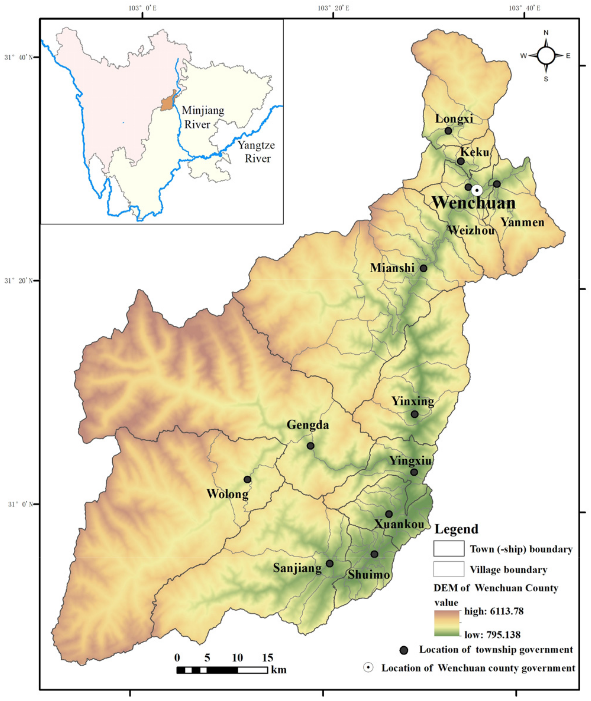
2.1. Current Status of the IERSE in Wenchuan

Wenchuan, located in the transition zone from the Tibetan Plateau to the Sichuan Basin, is a county under the jurisdiction of Aba Tibetan Qiang Autonomous Prefecture of Sichuan Province, southwestern China. It is situated in the Upper reaches of Minjiang River, a first-order branch and the largest water flow of the Yangtze River (Figure 1). The landform is positioned in a typical alpine-canyon region with a notable vertical climate and vegetation as well as rich animal and plant diversity. Wenchuan is an important part of the Giant Panda National Park. In addition, owing to lying in the Longmenshan fault belt, Wenchuan County is an earthquake and geological disaster-prone area. Under the dual impacts of climate change and human activities, regional ecological vulnerability has increased in the past decades [23]. Moreover, large scale reforestation and forest conservation programs, such as the Natural Forest Protection Project and the Slope Land Conversion Project (also called the Grain for Green Project), alongside extensive natural resource extraction, such as hydropower development and post-earthquake reconstruction, have occurred in the region recently. The rural area of Wenchuan poses great challenges to the implementation of National Rural Revitalization, as well as Northwest Sichuan Ecological Demonstration Zone strategies. Correspondingly, it is imperative to describe the IERSE and its spatial pattern in Wenchuan, assisted by appropriately designed approaches, which could provide a positive opportunity to rationally examine the holistic ecological status and benefits of targeted environmental management for local policy makers.

2.2. Assessment Indicator System and Data Sources

First and foremost, the data availability, reusability and analytic reproducibility were considered. Secondly, the authors comprehensively reviewed the official documents closely related to improving the IERSE; namely, The Measures for the Evaluation and Assessment of Ecological Civilization Construction Goals [24], The Green Development Indicator System, The Assessment Target System for The Construction of Ecological Civilization [25], and The Strategic Plan for Rural Revitalization in Sichuan Province (2018–2022) [26]. Thereafter, the evaluation index system for the IERSE of Wenchuan County, comprising two domains of eco-environmental and socioeconomic indicators, was proposed (Table 1).
For the ecological environment domain, three dimensions of ecological conservation, human settlements, and the production environment were utilized to express the natural environment, human habitat environment, and agriculture production environment, respectively. Specifically, the ecological conservation status was characterized by the remote-sensing-based ecological index (RSEI), which can objectively and comprehensively demonstrate ecological quality [27]. The state of the human settlement environment was illustrated by four aspects: sanitary toilets, garbage collection, sewage treatment, and environmental sanitation maintenance. The production environment status was displayed by chemical fertilizer and pesticide utilization and agricultural waste recycling. For the social development domain, the evaluation indicators were selected from the three dimensions of public service, economic development, and villager autonomy. Among them, the public service level was indicated by public facility or infrastructure supply, such as streetlights, gas, running water, medical care, and public open space. The economic status dimension included three specific indicators: disposable income of rural residents, village collective income, and the rural tourism income. It should be emphasized that relying on unique natural landscapes and humanities resources and actively promoting the integrated development of agriculture and tourism by local government has led to impressive economic benefits in rural Wenchuan [28]. As such, rural tourism income was introduced into the assessment system as one of important economic indicators. The human or villagers’ autonomy level has a substantial impact on villagers’ participation in improving the IERSE [29]. Hence, the education level of the village Party secretary and village head, as well as the number of villager meetings, were proposed to stand for the villagers’ autonomy dimension.
The RSEI was calculated from the Landset8 data, and the calculation process is detailed in reference [27]. The indicators of the human settlement environment, production environment, public services, economic status, and villagers’ autonomy were extracted from the statistical data of towns and villages in Sichuan Province in 2018, provided by the Sichuan Provincial Bureau of Statistics. There was a total of 118 administrative villages under the jurisdiction of Wenchuan County in 2018. Due to missing data, Zhitai Village was excluded from this study.

2.3. Indicator Empowerment

The method for empowering indicator weight usually includes three methods: subjective weighting, objective weighting, and combined subjective-objective weighting. The advantage of combined subjective-objective weighting has been increasingly recognized [30]. The common weight combination method mainly comprises additive and multiplicative composition, as well as gradation maximization, etc. For additive or multiplicative combination weighting, neither cautiously inspects the operational rationality by directly adding or multiplying subjective and objective weights. Gradation maximization combination weighting obtains the combined weight by solving the objective function of the optimization model within a reasonable range, which is a scientific mean but requires much more complicated computation.
Game theory is the mathematical analysis of the “both encompassing and reconciling conflicts where possible” [31]. The combined weighting based on game theory was founded on the independent calculation of each weight value, by pursuing the weights’ equilibrium to achieve the optimal weight combination [21,32]. The weight confirmation process is as follows: (1) building a weight set by multiple weights; (2) obtaining the optimal vector of the weight set, from which the sum of deviations is minimum; and (3) obtaining the final combined weight. The calculation process is deemed to be scientific, comprehensive, objective, and easily implemented [21]. Thus, our study took this means to empower each evaluation indicator. Specifically, the subjective weight was obtained by the Analytic Hierarchy Process (AHP) method [33] and the objective weight through the CRiteria Importance Through Intercriteria Correlation (CRITIC) [34] method. In this paper, X i j uniformly stood for the original value of index j   1 j m in administrative village i   1 i n .

2.3.1. AHP

Abiding by the AHP procedure, Yaanp software was employed in this study to establish the hierarchical structure model, build the judgment matrix, realize the hierarchical single sorting and consistency check, and obtain the indicator subjective weight [35].

2.3.2. CRITIC

As an objective weight calculation method, CRITIC considers both the difference of and the correlation between indicator values [34] and was intended as a better objective weighting method than the entropy method [30]. This paper adopted CRITIC to calculate the indicator objective weight.

2.3.3. Combined Weight Based on Game Theory

The indicator weights obtained by different methods may vary greatly or even conflict with each other. Therefore, the consistency test of weights needs to be accomplished from the beginning. The formula is as follows:
d w j _ a w j _ c = 1 2 j = 1 m w j _ a w j _ c 2 1 2
where w j _ a and w j _ c are the weights of the two groups involved in the game. When d w j _ a w j _ c < 0.2 , it is considered that it can be combined.
The basic weight vector set w = w j _ a , w j _ c T was established by the AHP and CRITIC method. The vector set was an arbitrary linear combination, w = a 1 w j _ a T + a 2 w j _ c T   . In order to achieve the minimization deviation between the combination weight w and two weights w j _ a , w j _ c , a 1 and a 2 could be obtained by the differentiation property of the matrix, while a 1 and a 2 will be acquired by normalization. The formula is as follows:
w j _ a w j _ a T w j _ a w j _ c T   w j _ c w j _ a T w j _ c w j _ c T   a 1 a 2 = w j _ a w j _ a T w j _ c w j _ c T
a 1 = a 1 a 1 + a 2
a 2 = a 2 a 1 + a 2
Finally, the combined weight could be calculated with the following formula:
w = a 1 w j _ a T + a 2 w j _ c T  

2.4. Assessment Method

There are many methods for evaluation and ranking, including the AHP, Data Envelope Analysis (DEA), Technique for Order Preference by Similarity to Ideal Solution (TOPSIS) and VIKOR methods. Their advantages and disadvantages are listed in Table 2 [36].
Recently, VIKOR has drawn increasing attention and gradually become one of the rational multi-criteria decision-making methods [36]. Its greatest merit is providing a compromise-feasible scheme for decision makers to comprehensively consider the maximum group utility and the minimum individual regret [20,37,38]. Based on the relative importance of indicators, group utility is taken to describe the overall difference among evaluated objects; that is, the sum of the distances between the indicator values and the ideal values of evaluated objects, whereas individual regret is utilized to reflect the weakest indicator of the valuated objects, namely the indicator with the maximum difference from the positive ideal solution. Taking into account the overall ecological construction level and the deficient factors, this paper applied VIKOR to measure and analyze the IERSE of Wenchuan. Furthermore, in order to guarantee the distance between the assessed objects and the ideal solution more scientifically and accurately [39], the Euclidean distance was replaced for the linear weighted distance commonly adopted in VIKOR. The main steps are as follows:
Normalize indicators:
f i j = x i j j = 1 m x i j 2
f i j = 1 x i j / j = 1 m 1 x i j 2
Determine the best f j + and the worst f j values of all indicators:
f j + = max j f i j
f j = min j f i j
Compute the values S i and R i based on the Euclidean distance
S i = j = 1 m w j f j + f i j 2 / f j + f j   2
R i = max j w j f j + f i j 2 / f j + f j   2
where w j is the weight of the j th criterion;
Compute the maximum and minimum group utility values S i + , S i ; and maximum and minimum individual regret values R i + , R i :
S i + = max i S i ;     S i = min i S i
R i + = max i R i ;     R i = min i R i
Compute values Q i
Q i = ε S i S i S i + S i + 1 ε R i R i R i + R i
where ε is introduced as a weight for the strategy of the maximum group utility, whereas 1 ε is the weight of individual regret. ε can be valued according to the decision-making needs. From different perspectives of group utility and individual regret, this paper took ε = 0 ,   0.2 ,   0.5 ,   0.8 ,   1 to show the evaluation results under different preferences.
Last but not least, two constraints should be satisfied when VIKOR is employed as follows.
(1) The prerequisite for excellent threshold value. To sort in accordance with the Q i value Q 2 Q 1 1 / n 1 should be fulfilled, where Q 1 represents the object value ranking ahead of Q i and Q 2 , meaning the object value ranking behind Q i . When this condition is satisfied, it indicates that the objects with higher rank are remarkably greater than the lower. (2) Decision reliability requirement. According to the Q i ranking, the evaluation objects with lower rank must also be lower ranked by S and/or R .

2.5. Spatial Correlation Analysis

The spatial distribution characteristics of geographical objects can be comprehensively examined through spatial statistical methods [40,41,42]. Spatial analysis is an important complementary tool for showing regional variations [43]. In this paper, the spatial statistical analysis module of ArcGIS software was operated to figure out three spatial correlation patterns of overall spatial autocorrelation, local spatial autocorrelation, and cold-hot spots of IERSE of Wenchuan County. The specific calculation models can be found in [40,41,42].

3. Results

According to VIKOR, the smaller the Q i value, the higher the rank and the better the IERSE. After obtaining the Q i values of all villages, we noted that some villages cannot be ranked only by Q i values in line with the two aforementioned constraints. The following two procedures were then conducted: (1) classify the Q i values of all villages into five grades basing on the Jenks Natural Breaks Classification method [44]; (2) specify the following rule: “The villages with Q i at the breakpoint have a distinct advantage over the villages behind them”. Eventually, the IERSE of all villages in Wenchuan were assessed without ambiguity. The acquired classification results are displayed in light of different ε values: 1, 0.8, 0.5, 0.2, 0 (Figure 2).
Figure 2 demonstrates that the holistic IERSE of Wenchuan is in a considerably positive status. The number of villages with the grade “excellent” or “good” was at least 49, accounting for 41.88% of the total. The number of villages above the median value was 59, accounting for 50.43%. Under different ε , Zhuanjinglou Village of Wolong Town remained first-rank. Assigning various alternative ε and subsequently getting their corresponding ranks is designed to meet the decision-making needs of diverse constituent rations of group utility and individual regret. Here, we took   ε = 0.5 in favor of keeping a balance between the group utility and individual regret.

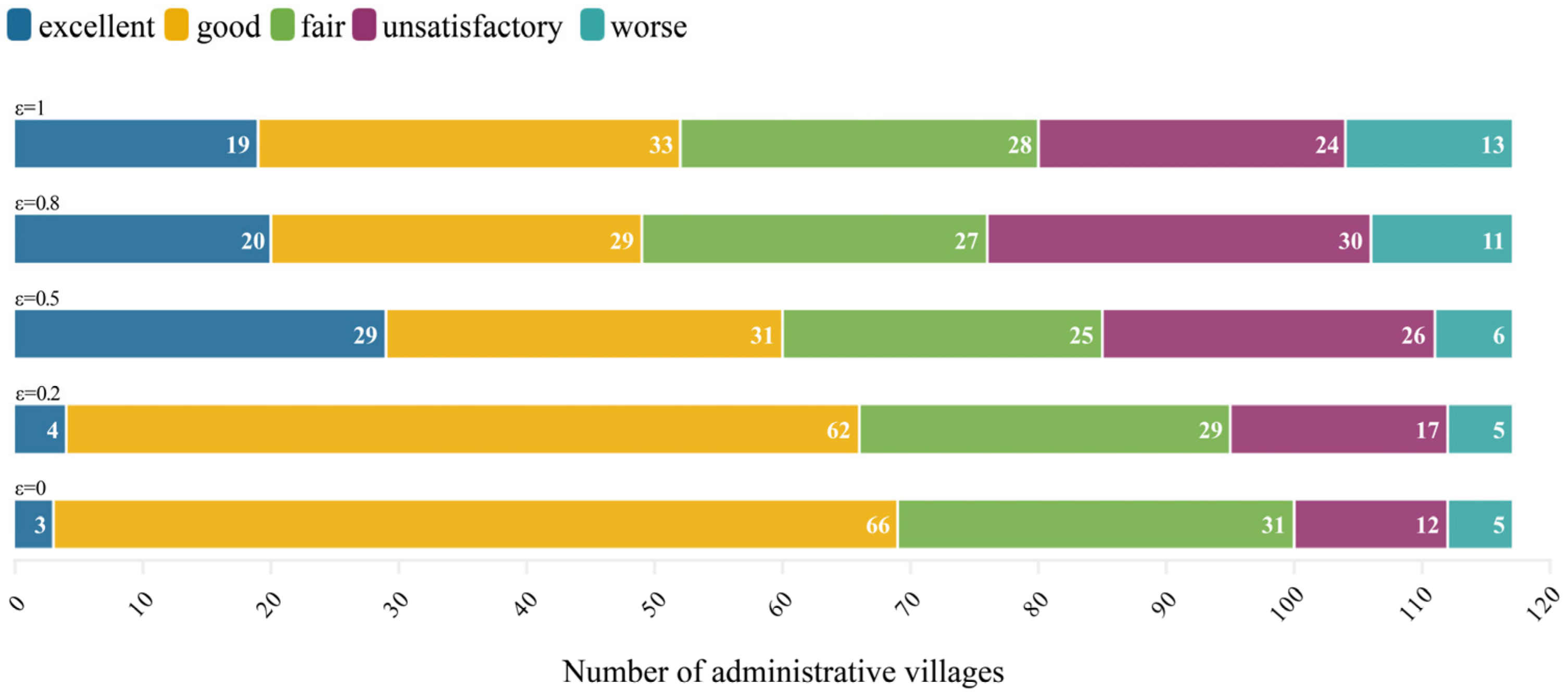
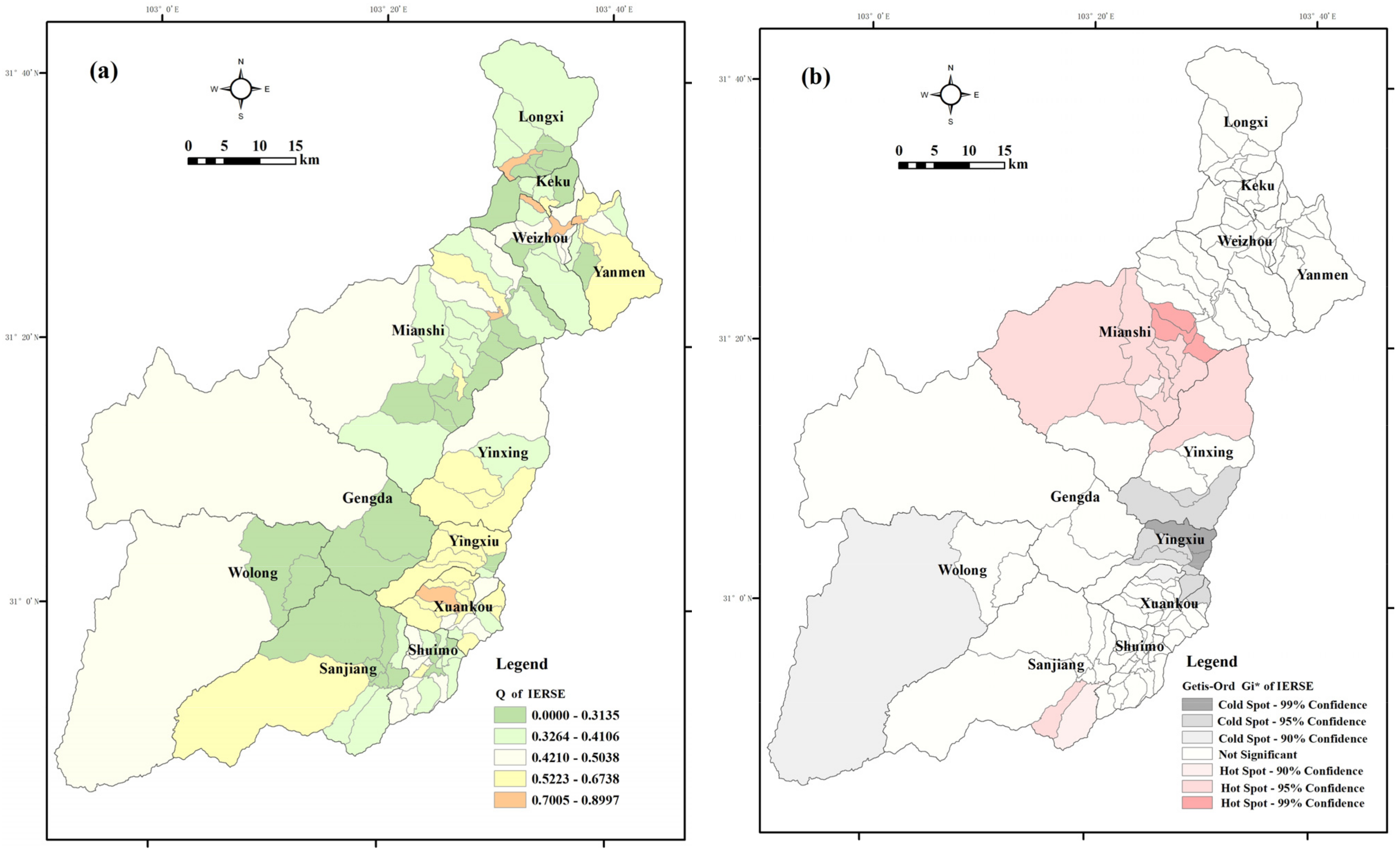
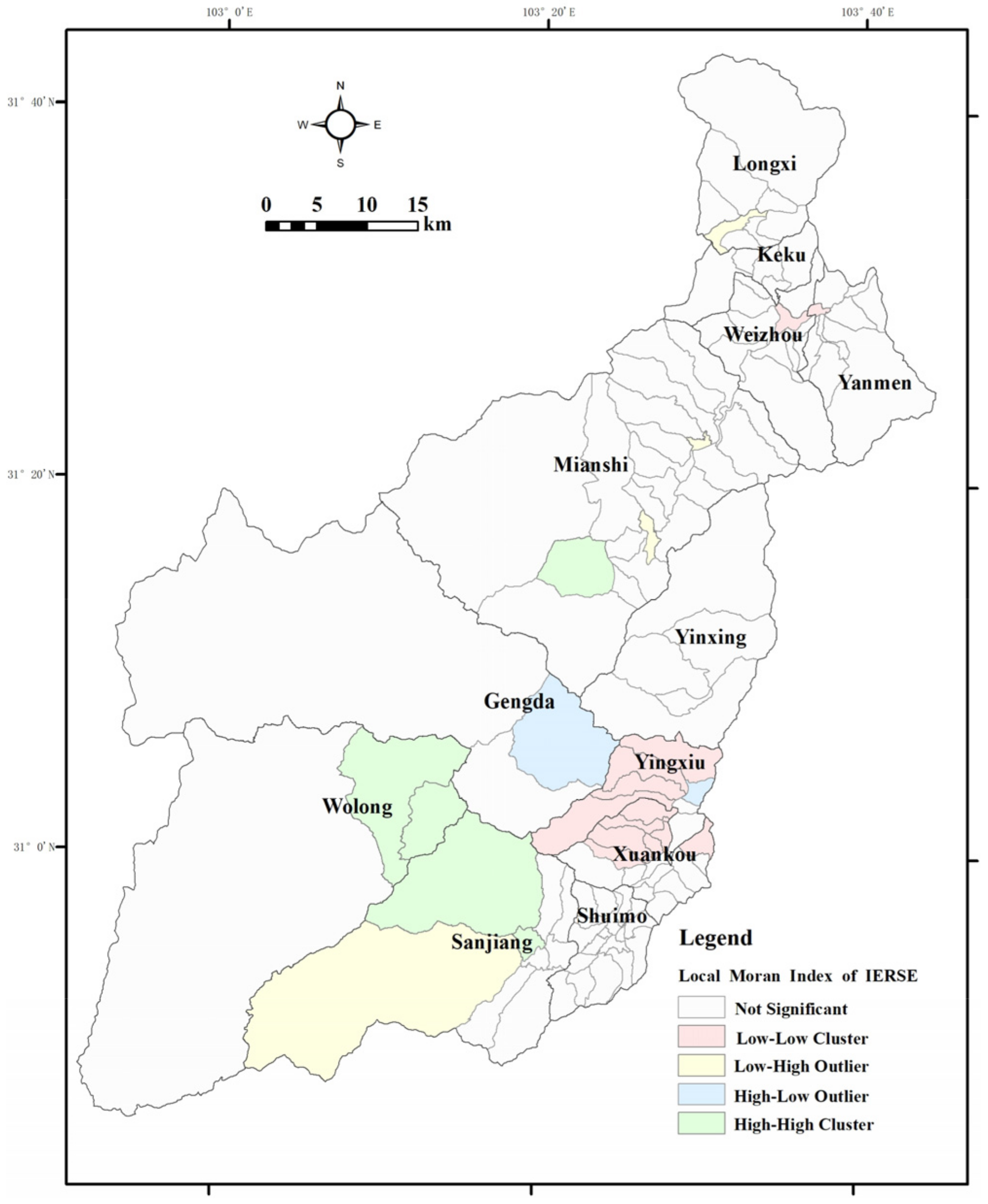
3.1. The IERSE in Wenchuan County

The detailed rank and classification of IERSE assessment for all villages in Wenchuan County are listed in Table 3.
The assessment results not only revealed the current status of IERSE of Wenchuan County, but also implied the cumulative effect of ecological construction in the long-term to a certain degree. On the whole, the IERSE of 117 villages in Wenchuan exhibits a relatively positive condition, with an average Q value of 0.4304. The sum of “excellent” and “good” villages was 60, accounting for 51.28% of the total, whereas the number of villages above average level was 64, accounting for 54.70%. From Figure 3, it can be seen that Wenchuan presented a spatial pattern with quite big differentiation of the IERSE. The villages with a favorable IERSE (grade excellent or good) are distributed along the northwest-central-southeast of the county, while the unfavorable villages (grade unsatisfactory or worse) mainly concentrate in the northeast and south-central. The top five villages in terms of the IERSE were Zhuanjinglou Village in Wolong Town, Longtan Village in Miansi Town, Jiecun and HebaVillage in Sanjiang Town, and Gengda Village in Gengda Town, whilst the lowest five were Lianhe Village in Longxi Township, Sanguanmiao Village in Miansi Town, Tieyi and Shuanghe Village in Weizhou Town, and Guojielou Village in Yanmen Township.
From the perspective of the town(ship)s level (Figure 3a), the following six town(ship)s showed favorable performance, mainly excellent and good IERSE: Longxi, Keku, Miansi, Gengda, Wolong and Sanjiang. Conversely, most IERSE values of Yanmen, Yinxing, Yingxiu and Xuankou town(ship)s were below grade, rated fair. Additionally, a large discrepancy in IERSE occurred for inter town(ship)s. In particular, Longxi, Weizhou and Miansi exhibited the most impressive differentiation due to both being graded excellent as well as the worst villages. Gengda, Wolong, Keku, Yingxiu and Xuankou also exhibited differentiation of IERSE, as the villages in the first four were generally classified as grade fair or above, and the villages in the last two mostly ranked below the grade of fair. Moreover, hot spots of IERSE were identified in the three villages (Figure 3b): Heping, Qiangfeng, and Gaodian of Miansi Town (99% confidence), while IERSE cold spots were observed in Laojie and Fengxiangshu of Yingxiu Town (99% confidence).
Global Moran’s I and Anselin Local Moran’s I were adopted to inspect the spatial correlation of IERSE in Wenchuan (Figure 4). (1) Global spatial correlation. According to Moran’s I 0.10, Z-score 3.93 and p-value 0.000084, there was a weak spatial positive correlation and weak agglomeration pattern for the entire IERSE in Wenchuan. (2) Local spatial correlation. As can be seen from Figure 4, most rural areas of Wenchuan have not yet shown a notable agglomeration pattern. The villages with favorable IERSE that passed the significance test mainly belonged to Miansi, Wolong and Sanjiang Town. The villages with unfavorable IERSE were located in Yingxiu and Xuankou Town.

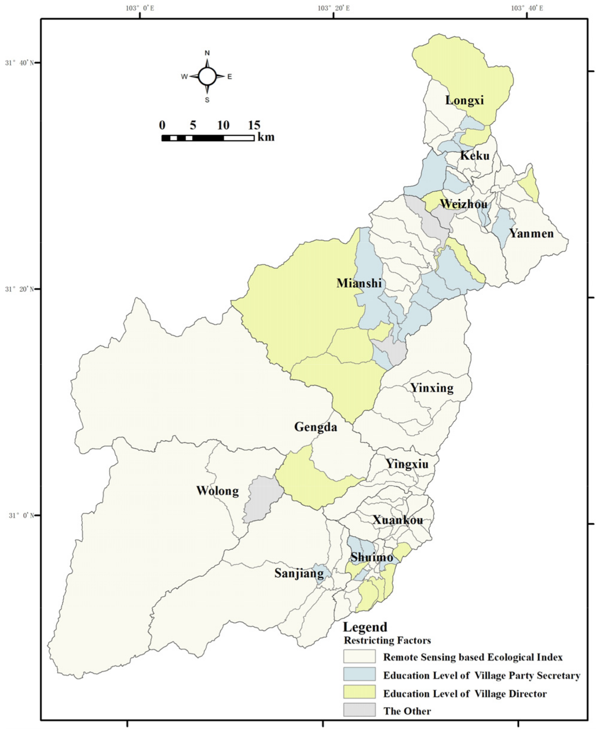
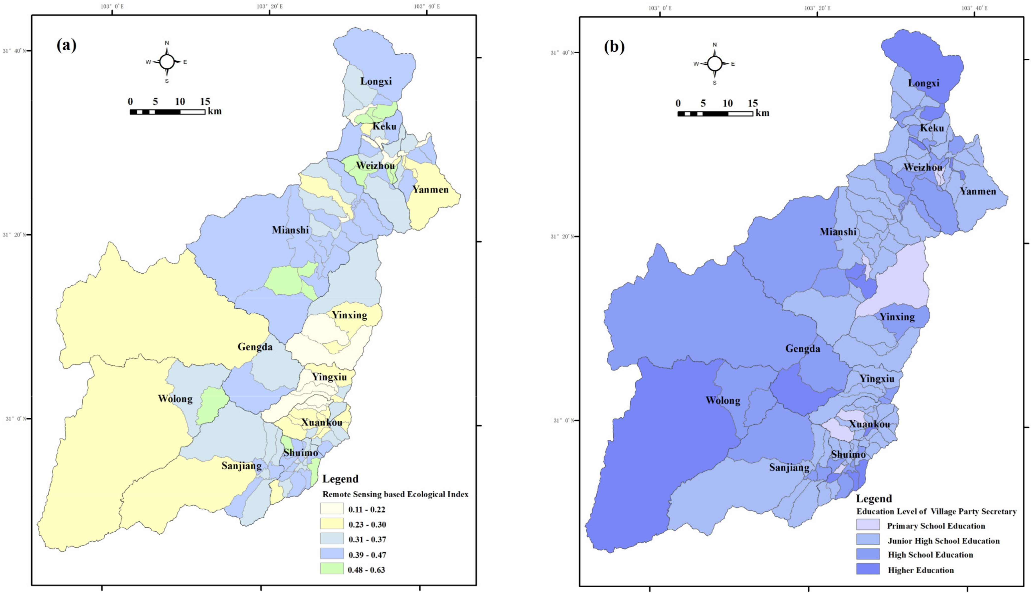
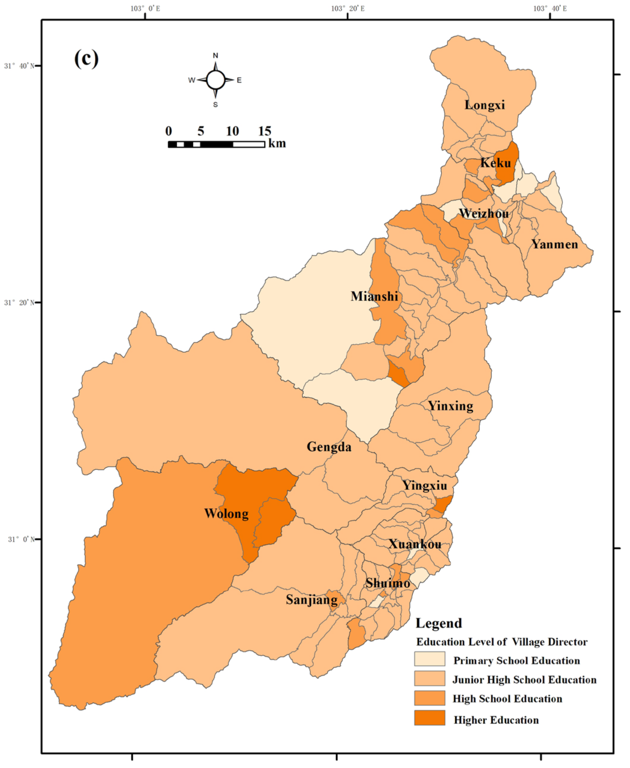
3.2. Restrictive Factors of IERSE in Wenchuan County

The individual regret values represent indicators with the lowest evaluation values. In this study, they were not only the shortcomings restraining IERSE, but also indicated the improvement direction for the future. For the IERSE of Wenchuan County, the ecological conservation dimension of the ecological environment domain, and the villagers’ autonomy dimension of the social development domain, are believed to be critical restrictive factors. More specifically, the number of villages constrained by the RSEI indicator, the education level of the village Party secretary, and that of the village head, were 76 (64.96% of the total), 22 (18.80%) and 15 (12.82%), respectively (Figure 5).
From the spatial distribution of RSEI (Figure 6a), the favorable ecological environment conservation areas were located in Longxi, Keku, and Miansi Town(ship)s, while the unfavorable areas were in Yinxing, Yingxiu, and Xuankou Town(ship)s, similar but not completely consistent with the spatial pattern of IERSE. As seen in Figure 6b, most village Party secretaries of Wenchuan County gained a junior or high school education. In Longxi, Miansi, and Wolong Town(ship)s, several village Party secretaries had received higher education experience, whereas the village Party secretaries with primary school education mostly lived in Yinxing Township and Xuankou Town. From Figure 6c, we can also note that most village heads of Wenchuan only attained a junior high school education, while a few village heads in Keku Township and Wolong Town received a higher education. When revisiting Figure 5 together with Figure 3, it can be noted that the most restrictive factor for areas with a favorable IERSE was embodied in the education level of village heads or Party secretaries. For the areas with an unfavorable IERSE, in contrast, the main restrictive factor was reflected in the RSEI of the ecological conservation status. Therefore, for future integrated development of socio-economic and environmental protection in Wenchuan, it is fundamental for policy-makers to thoroughly take into account the restrictive factors of the local IERSE, which will greatly benefit the implementation of differentiated and targeted countermeasures related to ecological environment management and social development initiatives.

4. Discussion

Currently, the VIKOR method is generally used in small-sample-size scheme ranking and optimization, with few reports on large-sample-size evaluation. This is mainly because the two constraints of VIKOR make it difficult to achieve a full ranking of all samples. Some scholars have attempted to solve this problem by combining Gray Correlation Analysis with VIKOR [39,45]. However, this kind of operation fails to highlight the superiority of the VIKOR method. Furthermore, how to logically integrate the above two methods into a whole approach has never been figured out. In our study, the Jenks Natural Breaks Classification method was introduced as a supplement to VIKOR for clarifying and ranking the classifications of all evaluation samples, which might provide a simple and feasible way to promote VIKOR for large-sample-size evaluation issues.
VIKOR focuses on both the group utility and individual regret of the evaluation subjects. This makes a compromise solution obtained acceptable for the decision maker, who is unable to or unaware of expressing his or her preference at the outset of the system design. In this study, additionally, the group utility is positive correlated with the IERSE and the individual regret indicates the restrictive factor for each village. For local decision makers, different assessment results can be obtained by adjusting these two aspects of attention and revealing restrictive factors can also provide directions for future integrated development of rural society and the environment. Although compared with VIKOR, TOPSIS, as the commonly used multi-criteria decision-making method, pays attention to both positive and negative ideal solutions but without considering their relative importance, which may lead to the so-called problem of “rank reversal” [37]. This means that the sample with the highest ranked alternative by TOPSIS is not always the closest to the ideal solution. For decision makers who are concerned about the assessment results, this phenomenon does not provide a good basis.
Over the past few decades, an unprecedented rapid urbanization growth was witnessed in China. This urbanization process was city-oriented with land-centered and land finance, which greatly promoted China’s economic and social development at the expense of agriculture and the rural environment, thus increasing inadequate rural development [46]. Compared with urban area, rural China is supposed to be facing greater challenges of comprehensive development of social economy and environmental protection. In light of these challenges, a “rural revitalization strategy”, targeted at solving serious rural issues, such as depopulation, industrial blight, cultural disinterest, ecological environment deterioration, etc., was outlined by the Chinese government in October 2017 [47]. One year later, the government issued the “Rural Revitalization Strategic Plan (2018–2022),” putting forward the “20-word” general requirements of industrial prosperity, ecological livability, rural civilization, effective governance, and quality of life [47]. From then on, China’s rural revitalization strategy has been officially advanced to the implementation stage. Against this context, how to understand the integrated effectiveness of rural socio-economic and environmental development is a topic worthy of further consideration, which might benefit from formulating differentiated recommendations connected with ecological environment management and social development initiatives for rural China. However, through literature reviewing, we found that the existing research papers pay little attention to the comprehensive development of the rural social economy and environment in microscale territorial spaces, such as administrative villages or the rural community. Hence, this literature gap provides us with a deserving chance to build up a holistic assessment approach to examine the comprehensive progress of certain rural area’s integrated effectiveness of socio-economic development and environmental protection.
In China, horizontal comparison or horizontal competition is a normal and important means used by different levels of government to promote the implementation of varied development and protection initiatives, such as the construction of ecological civilization and beautiful villages. In terms of this study, the assessment results showed different constraints on improving the IERSE for different villages. Therefore, the study not only proposed a concise and feasible approach to promote the sorting and ranking function of VIKOR toward evaluation research with relatively big samples, but also offered scientific evidence for local decision makers (such as leaders at county level) to make targeted policy on increasing the synergy of socio-economic development and environmental protection in rural areas.
This paper aimed to introduce a new approach to assess the IERSE at the village level in Wenchuan County, to offer scientific evidence for targeted improvement of the IERSE for local policy-makers, as well as to expand the horizon for assessing regional IERSE. Owing to the poor availability of long-term and measurable research data in rural areas, certain deficiencies in the IERSE assessment index system still exist, and a multi-period comparative study was not able to be implemented in this paper. Simultaneously, several evaluation dimensions may not have been fully demonstrated by the limited indicators used in this study, such as the ecological conservation and villagers’ autonomy dimensions. The corresponding proxy indicators could be obtained and supplemented by online questionnaires in future study.

5. Conclusions

With the assistance of game theory combined weighting and the VIKOR method, the IERSE at the village scale of Wenchuan County was assessed. The main findings are as follows.
(1) The VIKOR method with the combined weight based on game theory, comprising group utility (overall construction level) and individual regret (construction constraints), was scientifically applied to assess the IERSE of Wenchuan. Additionally, the Jenks Natural Breaks Classification method was proposed as a complementary underpinning for VIKOR to achieve fully ranking evaluation samples. This study provided a concise and feasible approach, as well as a case study, to promote VIKOR for large-sample-size evaluation.
(2) As of 2018, the general IERSE in Wenchuan was considerably positive, with 60 grade excellent or good villages, accounting for 51.28% of the total. The favorable villages were located along the northwest-central-southeast, whereas the unfavorable ones were mainly distributed in the northeast and south-central areas. Six town(ship)s had a favorable IERSE, with mainly grade excellent or good, while four town(ship)s had the below grade fair, for an unfavorable IERSE. A weak spatial positive correlation and weak agglomeration of global spatial correlation was found in Wenchuan. For the local spatial correlation pattern, only the areas of Miansi, Wolong, and Sanjiang Town had a significant agglomeration of favorable IERSE, while those of Yingxiu and Xuankou Town displayed an agglomeration of unfavorable IERSE values.
(3) From the perspective of the village scale, the IERSE of Wenchuan is mainly impacted by the constraints of ecological conservation (RSEI) and villagers’ autonomy (the education level of village Party secretaries or village heads). Villages with favorable IERSE are principally constrained by the education level of village heads or Party secretaries, whereas villages with unfavorable IERSE are predominantly restricted by the RSEI of ecological conservation. For the future integrated development of socio-economic and environmental protection, the restrictive factors of local IERSE will be of fundamental importance, benefiting the proposal of differentiated and targeted recommendations related to ecological environment management and social development initiatives.

Author Contributions

J.Z.: Conceptualization, Methodology, Resources, Writing—original draft, Writing—review and editing. S.Z.: Data curation, Visualization, Writing—original draft, Writing—review and editing. All authors have read and agreed to the published version of the manuscript.

Funding

This research was funded by the National Key R&D Program of China (No. 2018YFD1100104), the National Science Foundation of China (No. 42071200), and the Youth Innovation Promotion Association of the Chinese Academy of Sciences (2018407).

Data Availability Statement

The data that has been used is confidential.

Conflicts of Interest

The authors declare no conflict of interest.

References

  1. Li, C.; Yuan, B.L.; Zhang, Y.P. Effect Assessment of Ecological Construction in China from 2008 to 2014. Pol. J. Environ. Studies 2019, 28, 1241–1246. [Google Scholar] [CrossRef]
  2. Huang, L.; Shao, Q.Q.; Liu, J.Y. Forest restoration to achieve both ecological and economic progress, Poyang Lake basin, China. Ecol. Eng. 2012, 44, 53–60. [Google Scholar]
  3. United Nations. Transforming Our World: The 2030 Agenda for Sustainable Development; United Nations, Department of Economic and Social Affairs: New York, NY, USA, 21 October 2015.
  4. Hák, T.; Janoušková, S.; Moldan, B. Sustainable Development Goals: A need for relevant indicators. Ecol. Indic. 2016, 60, 565–573. [Google Scholar] [CrossRef]
  5. Huan, Y.Z.; Liang, T.; Li, H.T.; Zhang, C.S. A systematic method for assessing progress of achieving sustainable development goals: A case study of 15 countries. Sci. Total Environ. 2021, 75, 141875. [Google Scholar] [CrossRef]
  6. Bernhard, W.; Harald, V. Evaluating Sustainable Forest Management Strategies with the Analytic Network Process in a Pressure-State-Response Framework. J. Environ. Manag. 2008, 88, 1–10. [Google Scholar]
  7. Bravo, G. The Human Sustainable Development Index: The 2014 Update. Ecol. Indic. 2015, 50, 258–259. [Google Scholar] [CrossRef]
  8. Malekmohammadi, B.; Jahanishakib, F. Vulnerability assessment of wetland landscape ecosystem services using driver-pressure-state-impact-response (DPSIR) model. Ecol. Indic. 2017, 82, 293–303. [Google Scholar] [CrossRef]
  9. Esen, Ö.; Yıldırım, D.Ç.; Yıldırım, S. Threshold effects of economic growth on water stress in the Eurozone. Environ. Ment. Sci. Pollut. Res. 2020, 27, 31427–31438. [Google Scholar] [CrossRef]
  10. Wackernagel, M.; Rees, W. Our Ecological Footprint: Reducing Human Impact on the Earth; New Society Publishers: Gabriola Island, BC, Canada, 1998. [Google Scholar]
  11. Nautiyal, H.; Goel, V. Sustainability assessment: Metrics and methods. In Methods in Sustainability Science; Elsevier: Amsterdam, The Netherlands, 2021; pp. 27–46. [Google Scholar]
  12. Charfeddine, L.; Mrabet, Z. The impact of economic development and social-political factors on ecological footprint: A panel data analysis for 15 MENA countries. Renew. Sustain. Energy Rev. 2017, 76, 138–154. [Google Scholar] [CrossRef]
  13. Destek, M.A.; Sinha, A. Renewable, non-renewable energy consumption, economic growth, trade openness and ecological footprint: Evidence from organization for economic Cooperation and development countries. J. Clean. Prod. 2020, 242, 118537. [Google Scholar] [CrossRef]
  14. Morrow, N.; Mock, N.B.; Gatto, A.; LeMense, J.; Hudson, M. Protective Pathways: Connecting Environmental and Human Security at Local and Landscape Level with NLP and Geospatial Analysis of a Novel Database of 1500 Project Evaluations. Land 2022, 11, 123. [Google Scholar] [CrossRef]
  15. Liao, B.; Zhang, Z.G. Literature Review and the Future Trends for Evaluation of Ecological Civilization. Resour. Dev. Mark. 2018, 34, 1354–1361. [Google Scholar]
  16. Zhou, Y.; Su, Q.H.; Li, Y.L.; Li, X.W. Spatial-Temporal Characteristics of Multi-Hazard Resilience in Ecologically Fragile Areas of Southwest China: A Case Study in Aba. Int. J. Environ. Res. Public Health 2022, 19, 12018. [Google Scholar] [CrossRef]
  17. Zhang, X.J.; Wang, Z.Q. How does paired assistance to disaster-affected areas (PADAA) contribute to economic sustainability? A qualitative analysis of Wenchuan County. Sustainability 2019, 11, 3915. [Google Scholar] [CrossRef] [Green Version]
  18. Wang, H.; Zhuo, Y. The necessary way for the development of China’s rural areas in the new era-rural revitalization strategy. Open J. Soc. Sci. 2018, 6, 97. [Google Scholar] [CrossRef] [Green Version]
  19. Xiao, Y.; Tian, K.; Huang, H.; Wang, J.; Zhou, T. Coupling and coordination of socioeconomic and ecological environment in Wenchuan earthquake disaster areas: Case study of severely affected counties in southwestern China. Sustain. Cities Soc. 2021, 71, 102958. [Google Scholar] [CrossRef]
  20. Opricovic, S. Multicriteria optimization of civil engineering systems. Fac. Civ. Eng. Belgrade 1998, 2, 5–21. [Google Scholar]
  21. Liu, T.Y.; Deng, Y.; Chan, F.L. Evidential supplier selection based on DEMATEL and game theory. Int. J. Fuzzy Syst. 2018, 20, 1321–1333. [Google Scholar] [CrossRef]
  22. Wang, Y.M.; Parkan, C. A general multiple attribute decision-making approach for integrating subjective preferences and objective information. Fuzzy Sets Syst. 2006, 157, 1333–1345. [Google Scholar] [CrossRef]
  23. Cui, P.; Lin, Y.M.; Chen, C. Destruction of vegetation due to geo-hazards and its environmental impacts in the Wenchuan earthquake areas. Ecol. Eng. 2012, 44, 61–69. [Google Scholar] [CrossRef]
  24. The Central Committee of the Communist Party of China The General Office of the State Council of the General Office. Assessment Method of Ecological Civilization Construction Objective. Gaz. State Counc. People’s Repub. China 2017, 2, 5–7. [Google Scholar]
  25. National Development and Reform Commission of the People’ s Republic of China. Green Development Index System, Assessment System of Ecological Civilization Construction; National Development and Reform Commission of the People’s Republic of China: Beijing, China, 12 December 2016. Available online: https://www.ndrc.gov.cn/xxgk/zcfb/tz/201612/t20161222_962826.html?code=&state=123 (accessed on 16 April 2022).
  26. Sichuan Development and Reform Commission. Strategic Plan for Rural Revitalization in Sichuan Province (2018—2022); Sichuan Development and Reform Commission: Sichuan, China, 1 April 2020. Available online: http://fgw.sc.gov.cn/sfgw/njzc/2020/4/1/a66d12f9c2524fd78397756ceee4d5e9.shtml (accessed on 16 April 2022).
  27. Xu, H.Q.; Wang, M.Y.; Shi, T.T.; Guan, H.D.; Fang, C.Y.; Lin, Z.L. Prediction of ecological effects of potential population and impervious surface increases using a remote sensing based ecological index (RSEI). Ecol. Indic. 2018, 93, 730–740. [Google Scholar] [CrossRef]
  28. Xu, P.; Lu, X.L.; Zuo, K.L.; Zhang, H. Post-Wenchuan earthquake reconstruction and development in China. In Disaster and Development; Springer: Cham, Switzerland, 2014; pp. 427–445. [Google Scholar]
  29. Gatto, A. A pluralistic approach to economic and business sustainability: A critical meta-synthesis of foundations, metrics, and evidence of human and local development. Corp. Soc. Responsib. Environ. Manag. 2020, 27, 1525–1539. [Google Scholar] [CrossRef]
  30. Peng, J.Q.; Zhang, J.M. Urban flooding risk assessment based on GIS-game theory combination weight: A case study of Zhengzhou City. Int. J. Disaster Risk Reduct. 2022, 77, 103080. [Google Scholar] [CrossRef]
  31. Morrow, J.D. Game Theory for Political Scientists; Princeton University Press: Princeton, NJ, USA, 1994. [Google Scholar]
  32. Roger, B.M. Game Theory: Analysis of Conflict; The President and Fellows of Harvard College: Cambridge, MA, USA, 1991; p. 66. [Google Scholar]
  33. Forman, E.H.; Gass, S.I. The analytic hierarchy process—An exposition. Oper. Res. 2001, 49, 469–486. [Google Scholar] [CrossRef]
  34. Diakoulaki, D.; Mavrotas, G.; Papayannakis, L. Determining objective weights in multiple criteria problems: The critic method. Comput. Oper. Res. 1995, 22, 763–770. [Google Scholar] [CrossRef]
  35. Wu, Z.N.; Shen, Y.X.; Wang, H.L. Assessing urban areas’ vulnerability to flood disaster based on text data: A case study in Zhengzhou city. Sustainability 2019, 11, 4548. [Google Scholar] [CrossRef] [Green Version]
  36. Lian, H. Evaluation on the Service Capability of Conventional Public Transport Based on Grounded Theory and VIKOR Multi-criteria Decision Making Method. Master’s Thesis, Chongqing Jiaotong University, Chongqing, China, 2018. [Google Scholar]
  37. Opricovic, S.; Tzeng, G.H. Compromise solution by MCDM methods: A comparative analysis of VIKOR and TOPSIS. Eur. J. Oper. Res. 2004, 156, 445–455. [Google Scholar] [CrossRef]
  38. Opricovic, S.; Tzeng, G.H. Extended VIKOR method in comparison with outranking methods. Eur. J. Oper. Res. 2007, 178, 514–529. [Google Scholar] [CrossRef]
  39. Zhang, X.; Liang, P.Y.; Chen, R.R. Evaluation of Service Innovation Ability of Regional Science and Technology Service Industry: Based on the Improved CRITIC-VIKOR Method. Sci. Technol. Manag. Res. 2020, 16, 60–69. [Google Scholar]
  40. Ord, J.K.; Getis, A. Local spatial auto correlation statistics: Distributional issues and application. Geogr. Anal. 1995, 27, 286–306. [Google Scholar] [CrossRef]
  41. Anselin, L. The local indicators of spatial association—LISA. Geogr. Anal. 1995, 27, 93–115. [Google Scholar] [CrossRef]
  42. Getis, A.; Ord, J.K. The analysis of spatial association by use of distance statistics. Geogr. Anal. 2010, 24, 189–206. [Google Scholar] [CrossRef]
  43. Montesanto, A.; Passarino, G.; Senatore, A.; Carotenuto, L.; De Benedictis, G. Spatial analysis and surname analysis: Complementary tools for shedding light on human longevity patterns. Ann. Hum. Genet. 2008, 72, 253–260. [Google Scholar] [CrossRef] [Green Version]
  44. Lu, Y.S.; He, T.; Xu, X.L.; Qiao, Z. Investigation the Robustness of Standard Classification Methods for Defining Urban Heat Islands. IEEE J. Sel. Top. Appl. Earth Obs. Remote Sens. 2021, 14, 11386–11394. [Google Scholar] [CrossRef]
  45. Xiao, L.Z.; Shao, W.J. VIKOR method based on grey correlation analysis Full ranking model of evaluation objects. Stat. Decis. 2011, 10, 171–173. [Google Scholar]
  46. Liu, Y.S. Introduction to land use and rural sustainability in China. Land Use Policy 2018, 74, 1–4. [Google Scholar] [CrossRef]
  47. Liu, Y.S.; Zang, Y.Z.; Yang, Y.Y. China’s rural revitalization and development: Theory, technology and management. J. Geogr. Sci. 2020, 30, 1923–1942. [Google Scholar] [CrossRef]
Figure 1. The spatial distribution of villages and towns in Wenchuan County.
Land 11 01912 g001
Figure 2. Classification of villages by IERSE in Wenchuan.
Land 11 01912 g002
Figure 3. The spatial distribution of IERSE in Wenchuan County; (a) Q of IERSE; (b) Getis-Ord Gi* of IERSE.
Land 11 01912 g003
Figure 4. Local Moran Index of IERSE in Wenchuan County.
Land 11 01912 g004
Figure 5. The spatial distribution of villages with three restrictive factors of IERSE in Wenchuan County.
Land 11 01912 g005
Figure 6. The spatial distribution of three restrictive factors of IERSE in Wenchuan County; (a) RSEI; (b) education level of village Party secretary; (c) education level of village head.
Land 11 01912 g006aLand 11 01912 g006b
Table 1. The indicator system for the IERSE of Wenchuan County.
DomainsDimensionsIndicatorsAttributionWeight
ecological environmentecological conservationremote sensing based ecological index (RSEI)benefit0.211
human settlementsproportion of villager group with sanitary toiletsbenefit0.037
proportion of households with centralized garbage collectionbenefit0.052
proportion of households with centralized sewage treatmentbenefit0.063
number of cleaners per hundred personsbenefit0.023
agricultural environmentaverage chemical fertilizer application per 666 m2cost0.036
average pesticide application per 666 m2cost0.036
recycling rate of agricultural waste utilizationbenefit0.026
social developmentpublic servicesproportion of village group with streetlightsbenefit0.055
proportion of village group with gasbenefit0.017
proportion of farmers with tap waterbenefit0.018
number of clinics per hundred personsbenefit0.019
number of sports squaresbenefit0.055
economic statusper capita disposable income of rural residentsbenefit0.038
per capita village collective incomebenefit0.031
village tourism incomebenefit0.054
villagers’ autonomyeducation level of village Party secretarybenefit0.094
education level of village headbenefit0.091
number of villager meetings per yearbenefit0.044
Table 2. Comparison table of common evaluation methods.
Assessment MethodAdvantagesDisadvantages
AHP(1) Comprehensive coverage, scientific and reliable;
(2) Evaluation structure is systematic and simple, easy to operate, low demand for quantitative data.
(1) Easily affected by subjective knowledge and experience;
(2) Limited number of indicators, too many indicators leading to huge workload during calculation process.
DEA(1) Dynamic traceability of computing process with weights as variables;
(2) Suitable for evaluating multi-index input complex systems.
(1) Limited scope of application, mostly for sorting validity issues;
(2) Just reflecting relative development of evaluation targets.
TOPSIS(1) Calculation process simple and clear, the results presented objectively and quantitatively;
(2) Suitable for handling multi-index dynamic evaluations.
(1) Relative importance of distances from the ideal and those from the negative ideal are not considered.
VIKOR(1) Calculation process simple and clear, results objective and quantitative;
(2) Suitable for multi-index dynamic assessment objects;
(3) Comprising indicators’ negative impacts.
(1) To achieve full ranking, it needs to meet harsh constraints.
Table 3. Detailed rank and classification of Wenchuan on IERSE assessment.
Evaluation RangeAdministrative VillageNumber of Villages in Different Town(ship)sClassification
0~0.3135Zhuanjinglou (WL), Longtan (MS), Jiecun (SJ), Heba (SJ), Gengda (GD), Mianfeng (MS), Xinqiao (WZ), EBu (LX), Yangdian (MS), Gaodian (MS), Madeng (LX), Dasi (KK), Zumushan (WL), Qishan (SJ), Fengxiangshu (YGX), Xiazhuang (KK), Longxi (LX), Lianghe (MS), Tongshan (YM), Xingfu (GD), Caoping (SJ), Zhaobi (SJ), Majiaying (SM), Zhangpai (MS), Xianfengyan (SM), Matou (MS), Bulan (LX), Banqiao (MS), Laoren (SM)WL: 2; MS: 8; SJ: 5; GD: 2; WZ: 1; LX: 4; KK: 2; YGX: 1; YM: 1; SM: 3; XK: 0; YX: 0.excellent
0.3264~0.4106Qipangou (WZ), Keyue (MS), Huangjia (YGX), Banpo (MS), Zengpo (WZ), Longzhu (SJ), Dengjia (LX), Aer (LX), Wancun (WZ), Kuapo (LX), Maopingzi (SM), Liujiagou (SM), Zhouda (KK), Guojiaba (SM), Niutanggou (SM), Mushang (KK), Maliu (SJ), Diaotou (MS), Kechong (MS), Jinbo (MS), Gaofeng (SM), Shapingguan (YX), Qunyi (XK), Dacaotou (SM), Zhaojiaping (XK), Luobozhai (YM), Qiangfeng (MS), Damen (LX), Heping (MS), Baishui (YM), Xiaomaoping (MS)WL: 0; MS: 8; SJ: 3; GD: 0; WZ: 3; LX: 3; KK: 2; YGX: 1; YM: 2; SM: 6; XK: 2; YX: 1.good
0.4210~0.5038Shapai (MS), Banzigou (MS), Bingli (WZ), Zhaiziping (SM), Dayandong (SM), Longtan (GD), Dengcaoping (SM), Cili (WZ), Baiguoping (SM), Anziping (XK), Niunaozhai (WZ), Jizhong (XK), Huangjiayuan (YGX), Baishi (SM), Taoguan (YX), Suoqiao (YM), Wolongguan (WL), Maoling (WZ), Baitukan (MS), Lianshanpo (SM), Yugongmiao (XK), Yubeiling (SM), Huangjiaping (SM), Chenjiashan (SM), Buwa (WZ)WL: 1; MS: 3; SJ: 0; GD: 1; WZ: 6; LX: 0; KK: 0; YGX: 1; YM: 1; SM: 8; XK: 3; YX: 1.fair
0.5223~0.6738Hongfushan (XK), Kongshan (YM), Guxigou (XK), Laojie (YGX), Maidi (YM), Heitupo (SM), Keku (KK), Hetaoping (XK), Xingwenping (YX), Younian (XK), Dongjienao (YX), Yuzixi (YGX), Zuwan (MS), Wayaogang (XK), Xicao (SJ), Tuyushan (MS), Bajiaomiao (XK), Xianghuanggou (XK), Shuitianping (XK), Yiwanshui (YX), Yueli (YM), Shengyinsi (XK), Zhongtanbao (YGX), Zhangjiaping (YGX), Caijiagang (XK), Qingpo (YM)WL: 0; MS: 2; SJ: 1; GD: 0; WZ: 0; LX: 0; KK: 1; YGX: 4; YM: 4; SM: 1; XK: 10; YX: 3.unsatisfactory
0.7005~0.8997Xiaomaxi (XK), Guojielou (YM), Shuanghe (WZ), Tieyi (WZ), Sanguanmiao (MS), Lianhe (LX)WL: 0; MS: 1; SJ: 0; GD: 0; WZ: 2; LX: 1; KK: 0; YGX: 0; YM: 1; SM: 0; XK: 1; YX: 0.worse
Notes: (1) WL, MS, SJ, GD, WZ, LX, KK, YGX, YM, SM, XK, YX means the village is located in Wolong Town, Miansi Town, Sanjiang Town, Gengda Town, Weizhou Town, Longxi Township, Keku Township, Yingxiu Town, Yanmen Township, Shuimo Town, Xuankou Town, and Yinxing Township, respectively; (2) the villages were sorted in an ascending order from the smallest to the largest value of Q .
Publisher’s Note: MDPI stays neutral with regard to jurisdictional claims in published maps and institutional affiliations.

