

The Allocation Change of Rural Land Consolidation Type Structure under the Influence Factors of Different Geographical and Economic Development of China


Abstract
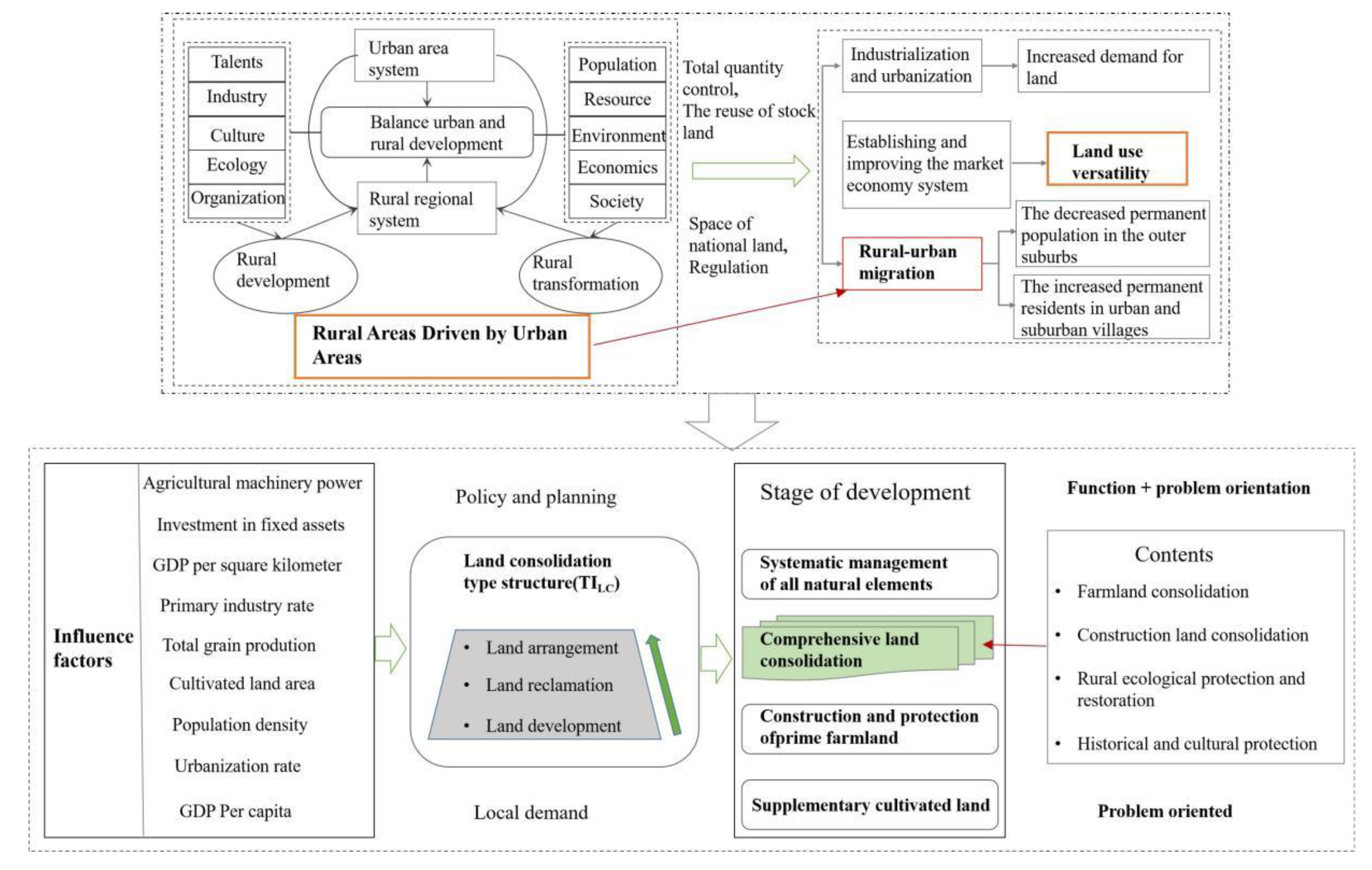
:1. Introduction
2. Materials and Methods
2.1. Data Sources
2.2. Correlation Analysis
2.3. Transition Index
2.4. PLSR
3. Results
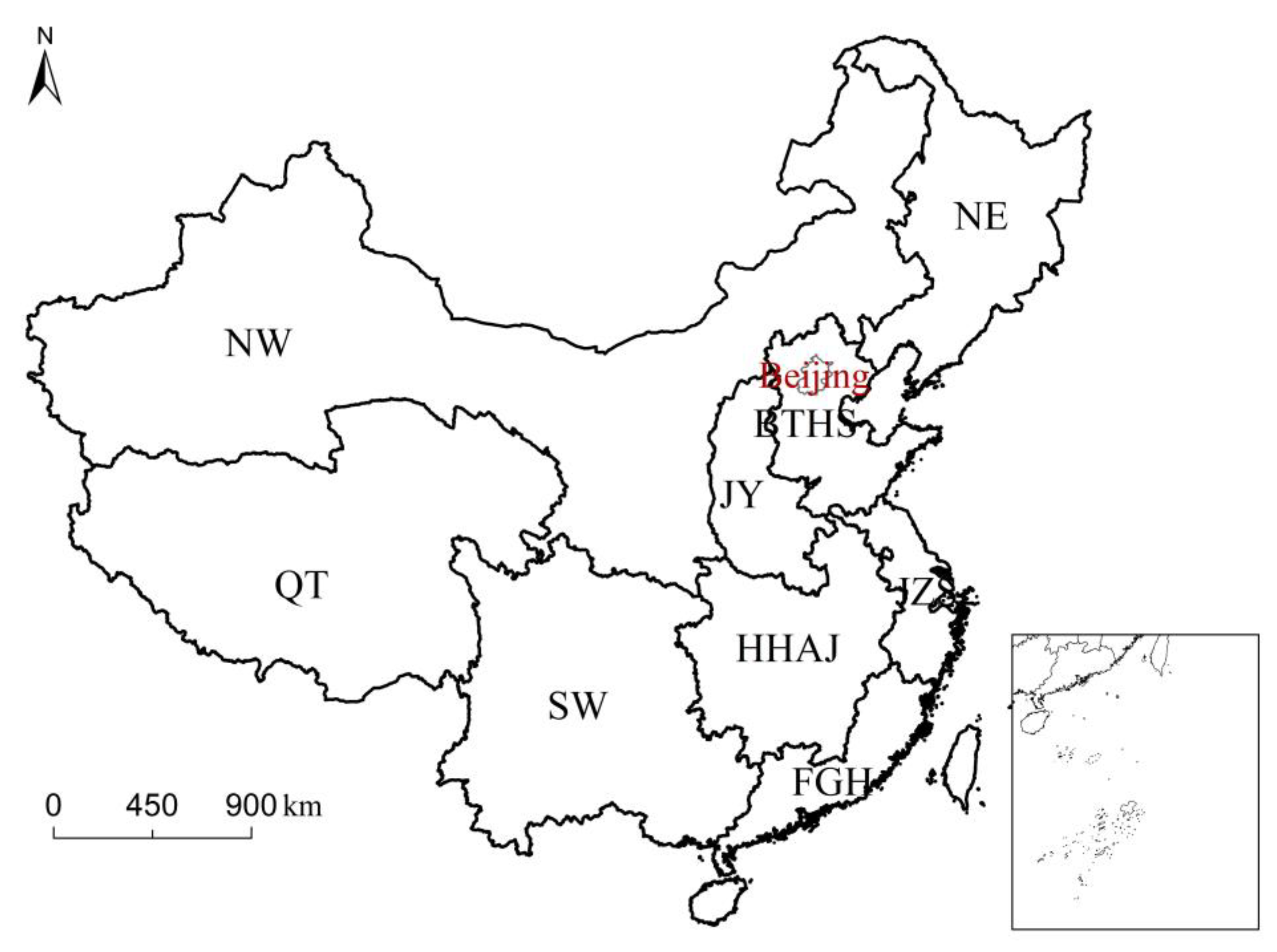
3.1. Temporal and Spatial Changes of Land Consolidation Type Structure
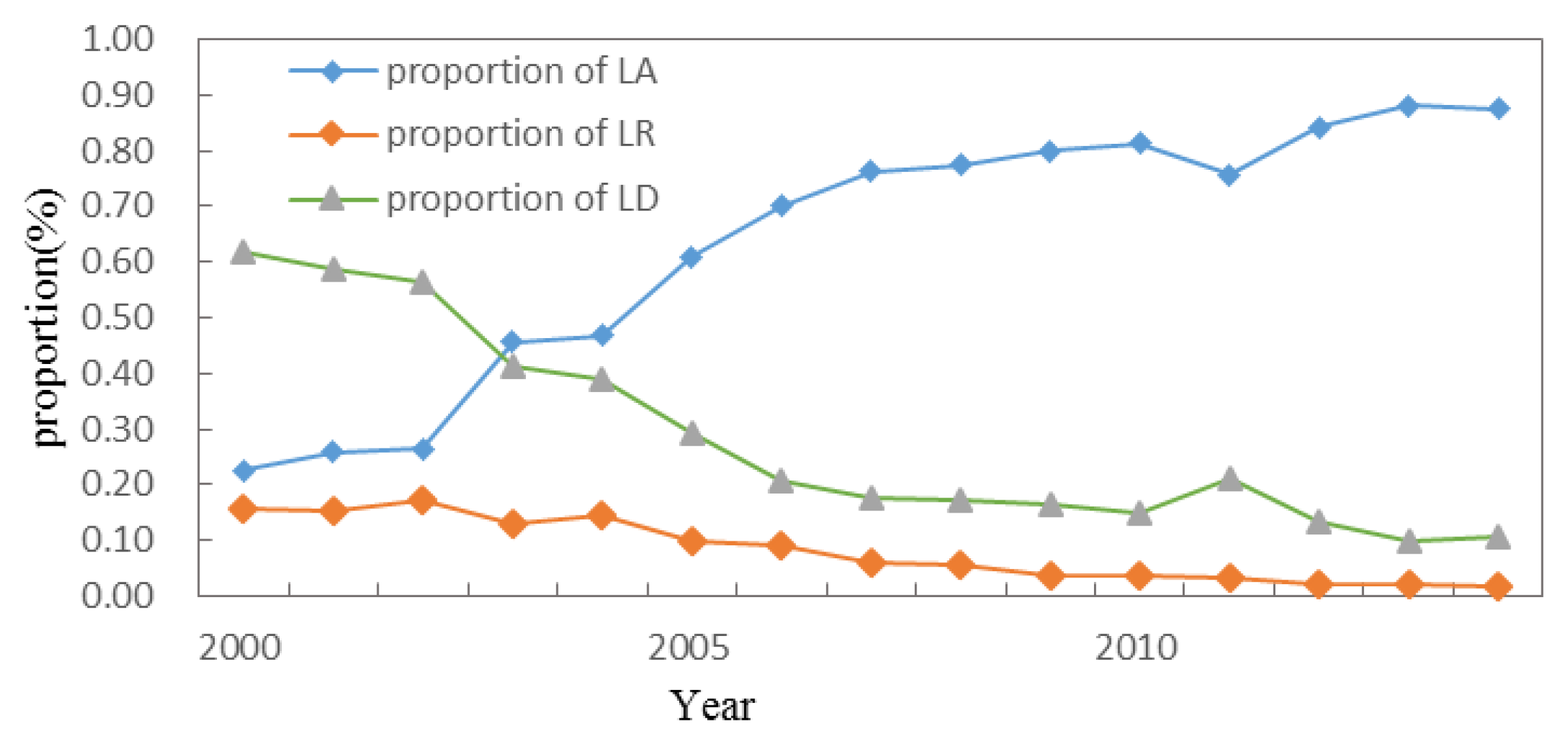
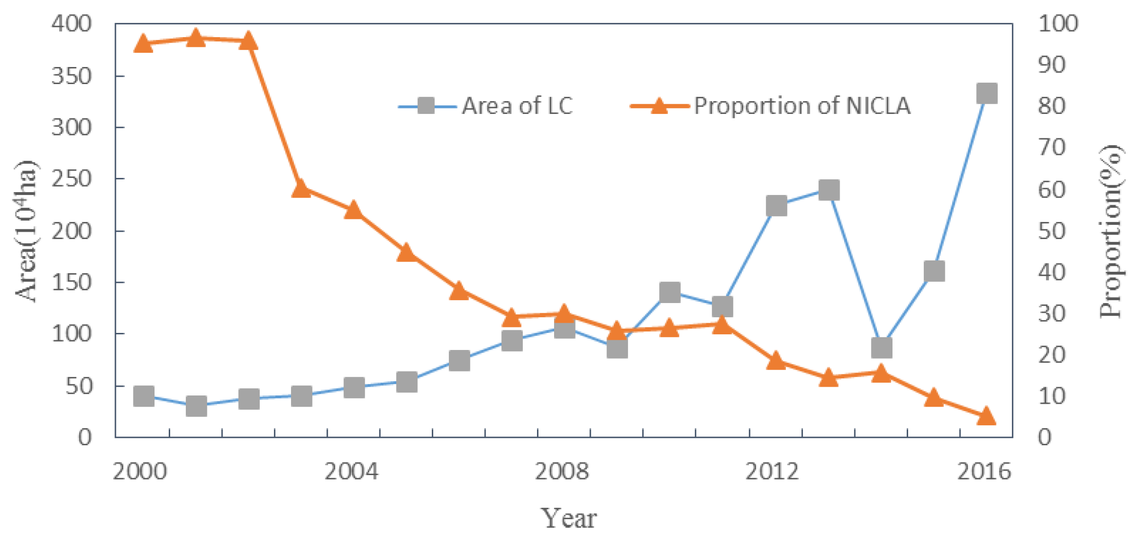
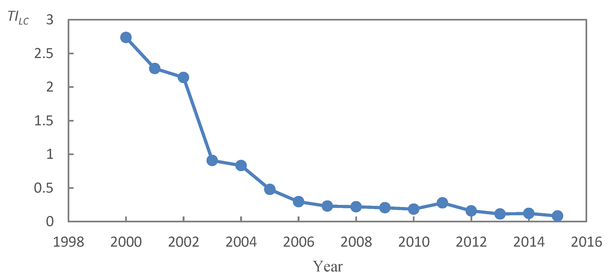
3.1.1. Temporal Variation of Land Consolidation Structure
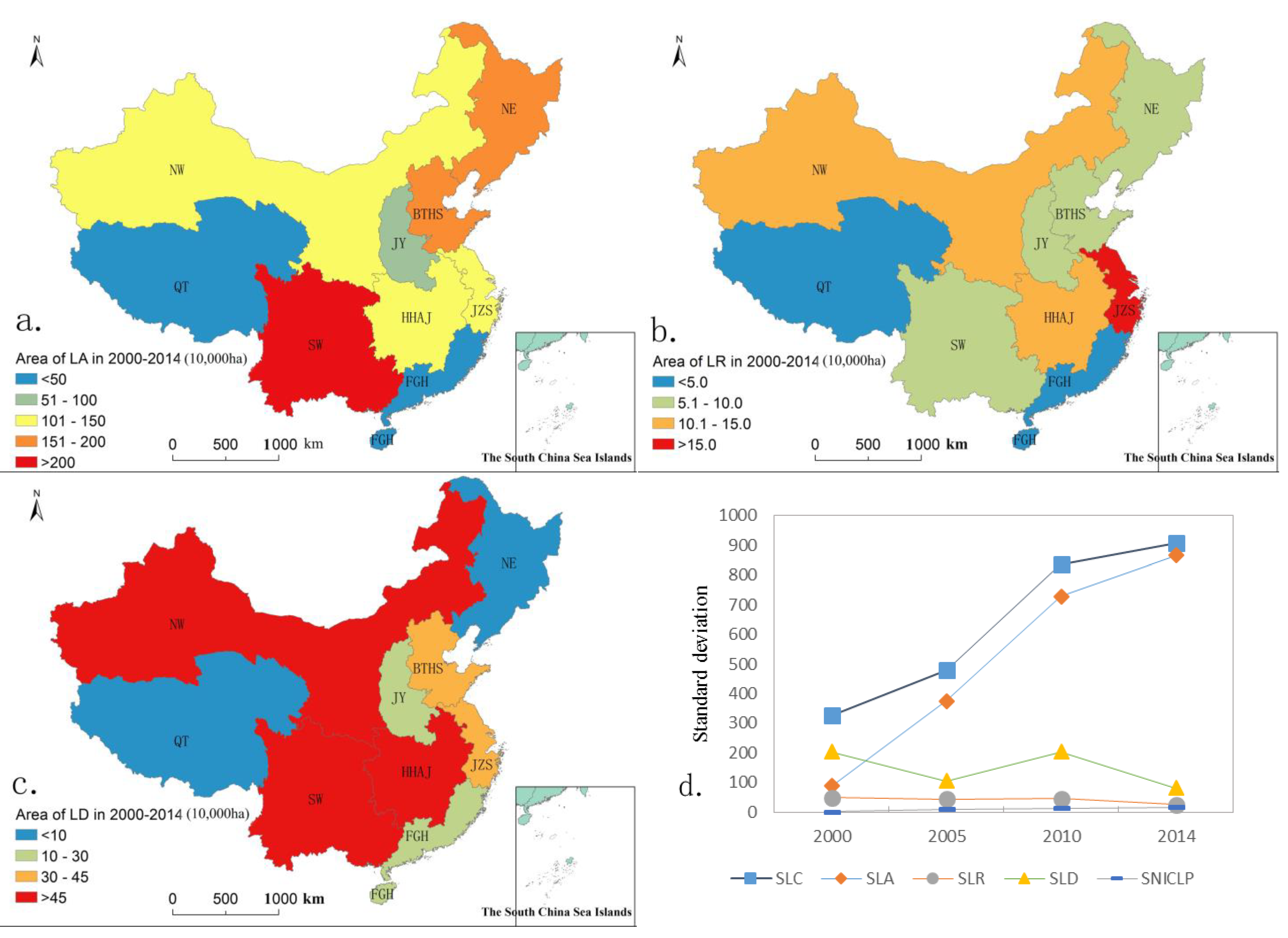
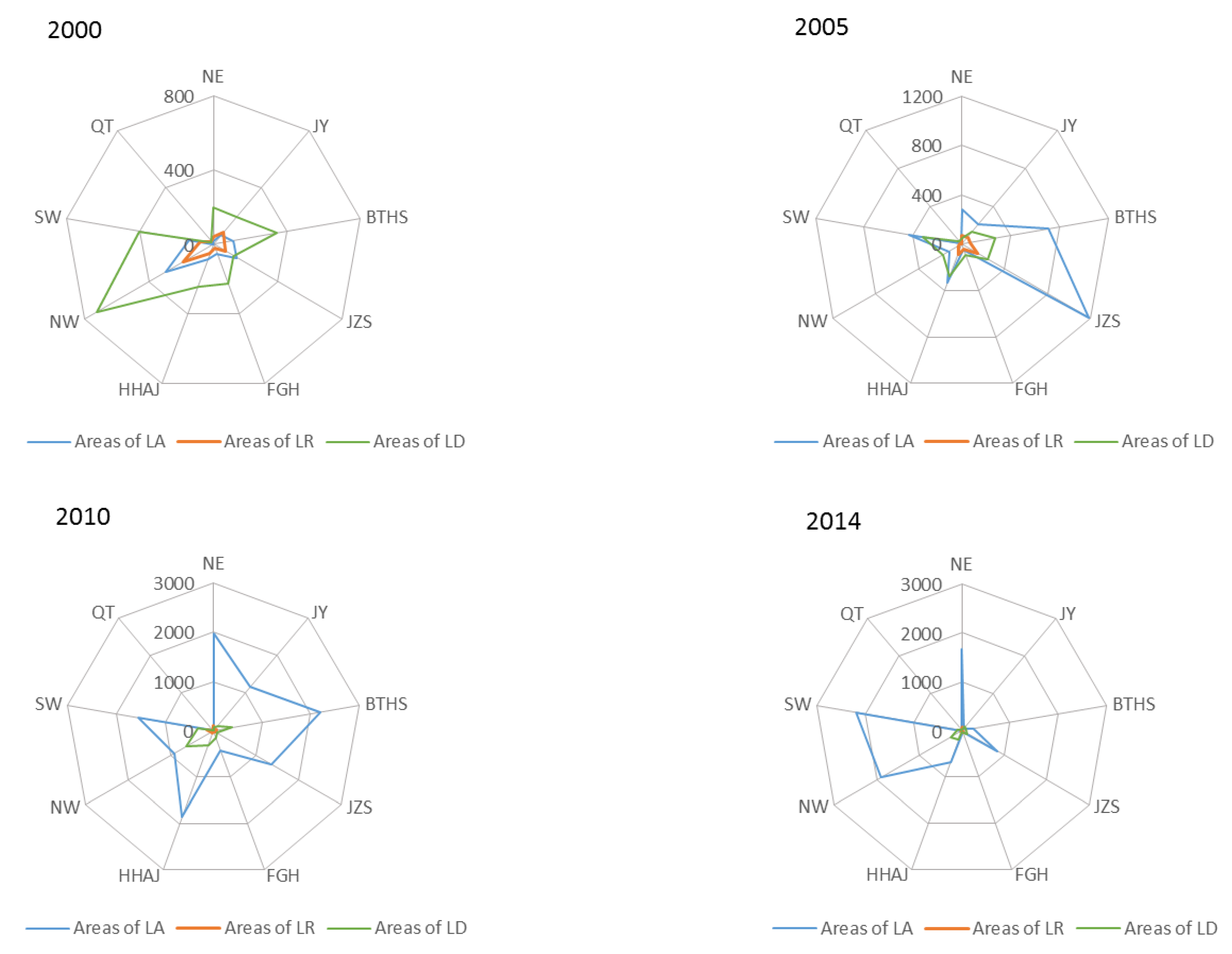
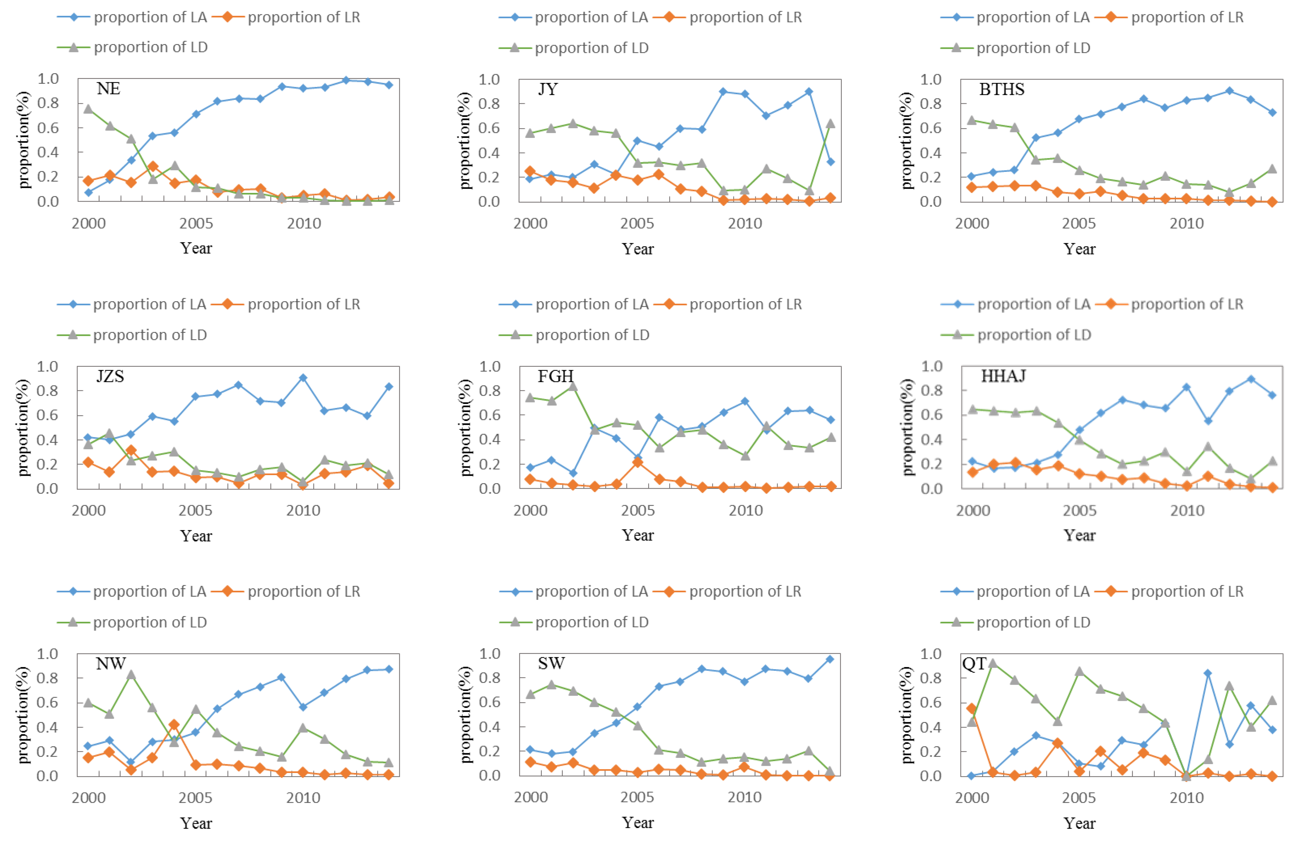
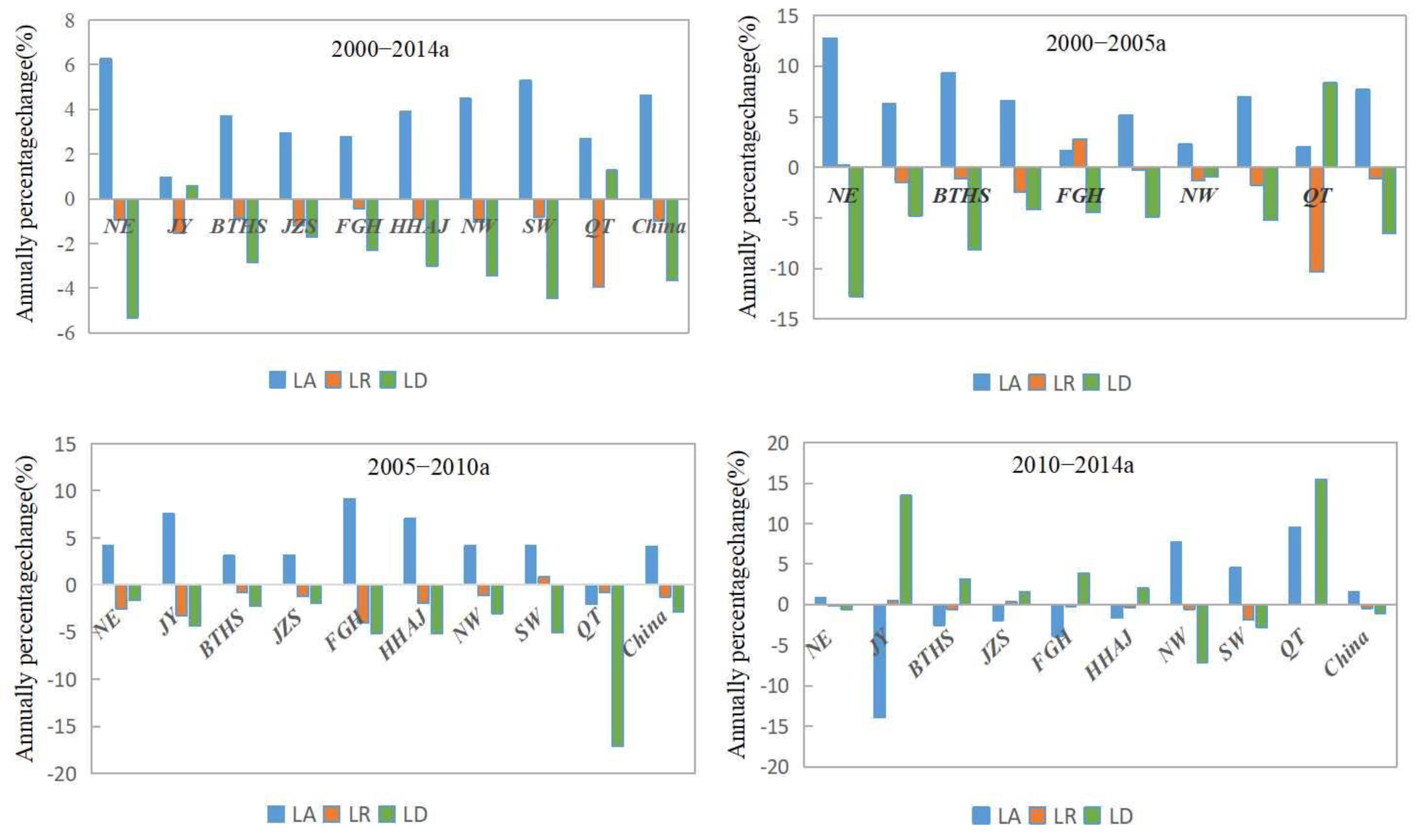
3.1.2. Spatial Difference and Change of Regional Land Consolidation Structure
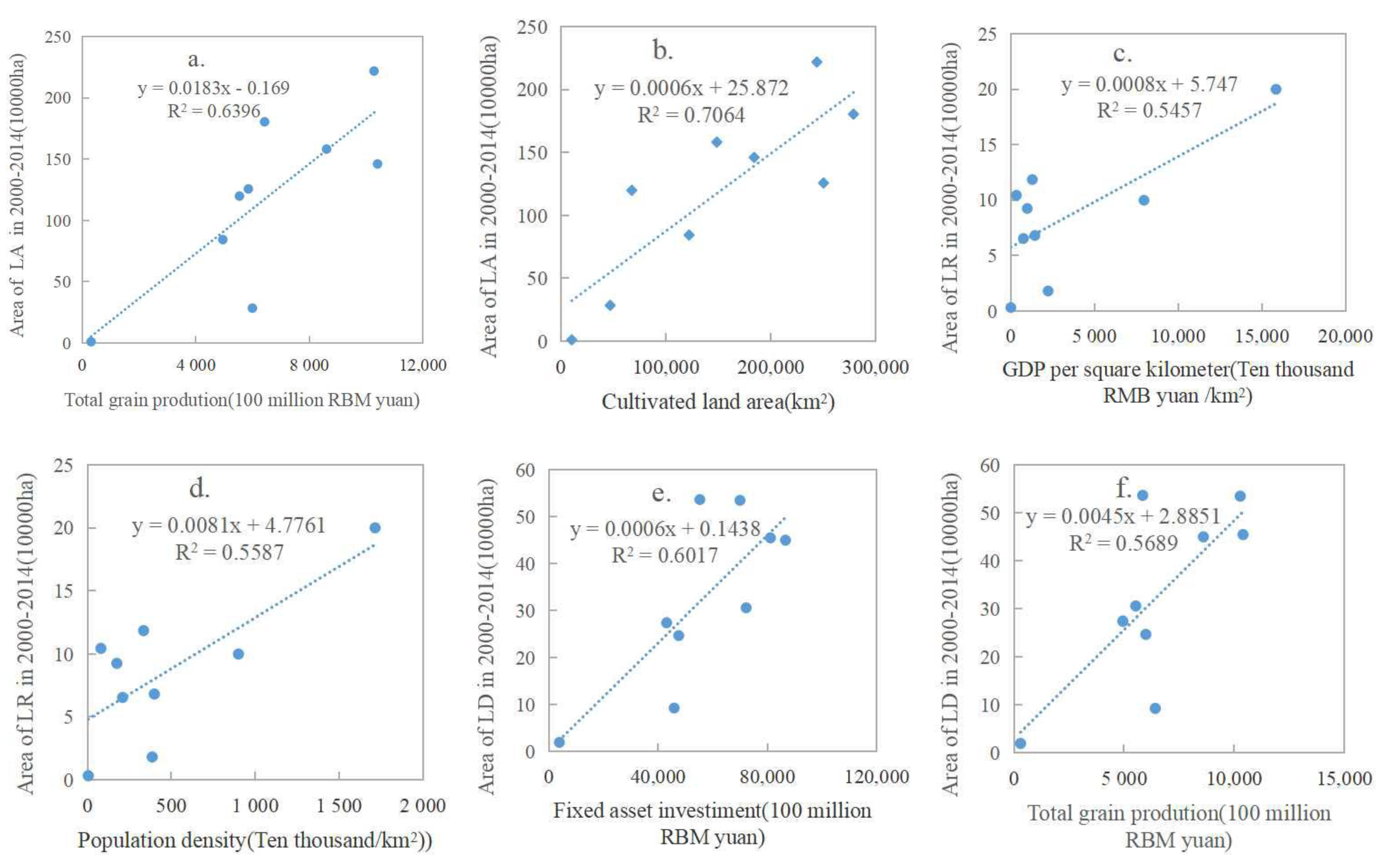
3.2. Influence Factors of Land Consolidation Structure
3.2.1. Overall Influencing Factors of Land Consolidation Structure
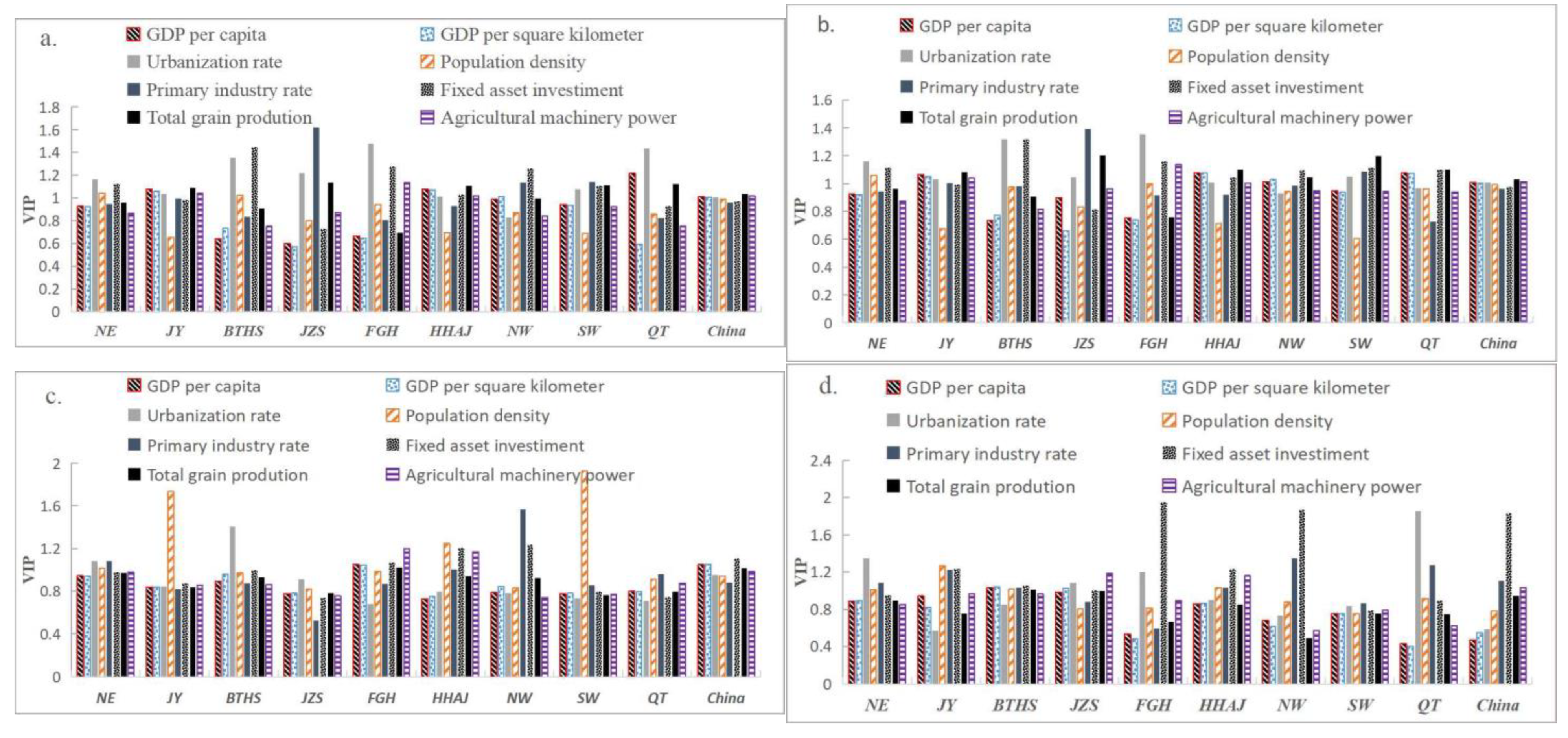
3.2.2. Influencing Factors of Land Consolidation Structure in Different Geographical and Economic Regions
4. Discussion
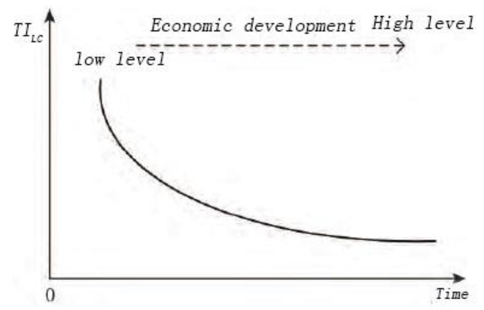
4.1. Change Mechanism of Land Consolidation Type Structure
4.2. Policy Implication
5. Conclusions
Author Contributions
Funding
Institutional Review Board Statement
Informed Consent Statement
Data Availability Statement
Conflicts of Interest
References
- Wang, W.M.; Zhang, Y. Land consolidation and sustainable development. China Popul. Resour. Environ. 2004, 14, 13–18. [Google Scholar] [CrossRef] [PubMed]
- Fan, M. Review and prospect of land consolidation in China. Trans. Chin. Soc. Agric. Eng. 2006, 22, 246–251. [Google Scholar]
- Liu, Y.S.; Zhu, L.; Li, Y.H. The Essential Theories and Models of Rural Land Consolidation in the Transitional Period of China. Prog. Geogr. 2012, 31, 777–782. [Google Scholar]
- Jiang, Y.F.; Long, H.L.; Tang, Y.T. Land consolidation and rural vitalization: A perspective of land use multifunctionality. Prog. Geogr. 2021, 40, 487–497. [Google Scholar] [CrossRef]
- Kong, X.S.; Wang, J.; Jin, Z.F.; Nai, L.L. Transformation and Innovation of Rural Land Consolidation towards Rural Vitalization. China Land Sci. 2019, 33, 95–102. [Google Scholar]
- Li, C.X.; Wu, K.N.; Wu, J.Y.; Hu, Q.; Song, H.F.; Liu, H.R. Focus and orientations of land consolidation research in China--Based on knowledge mapping citespace. Chin. J. Agric. Resour. Reg. Plan. 2017, 38, 46–53. [Google Scholar]
- Zhao, Q.L.; Jiang, G.H.; Xiong, C.; Yan, G.Q.; Su, S. Study on land consolidation function zoning and its consolidation direction. Chin. J. Agric. Resour. Reg. Plan. 2021, 42, 52–60. [Google Scholar]
- Zhang, H.P. The Evolution of China’s Urban-Rural Relations in the Past Seven Decades: From Separation to Integration. Chin. Rural. Econ. 2019, 411, 2–18. [Google Scholar]
- Lv, M.j.; Chen, Z.T.; Yao, Y.L.; Dang, X.H.; Li, P.; Cao, X.S. Potential Zoning of Construction Land Consolidation in the Loess Plateau Based on the Evolution of Human-Land Relationship. Int. J. Environ. Res. Public Health 2022, 19, 14927. [Google Scholar] [CrossRef]
- Liu, H.N.; Wang, D.Q.; Zhou, X. Mechanism and progress of how land consolidation promote the regional economies coordinated development-Based on the modified stock-flow model. Chin. J. Agric. Resour. Reg. Plan. 2015, 36, 23–28. [Google Scholar]
- Xu, X.X.; Xiang, X.M.; Jin, X.B.; Zhou, Y.K. System Dynamics Analysis for the Socio-economic Impacts of Land Consolidation: Methodology and Empirical Study. China Land Sci. 2015, 29, 73–80. [Google Scholar]
- Li, X.S.; Jin, Z.J.; Xiong, L.Y.; Tong, L.C.; Zhu, H.Y.; Zhang, X.W.; Qin, G.F. Effects of Land Reclamation on Soil Bacterial Community and Potential Functions in Bauxite Mining Area. Int. J. Environ. Res. Public Health 2022, 19, 16921. [Google Scholar] [CrossRef] [PubMed]
- Li, S.C.; Song, W. Research Progress in Land Consolidation and Rural Revitalization: Current Status, Characteristics, Regional Differences, and Evolution Laws. Land 2023, 12, 210. [Google Scholar] [CrossRef]
- Janečková, M.K.; Sklenička, P.; Bohnet, I.C.; Lowther, H.F.; Van, d.B.A.; Movahhed, M.S.; Fanta, V.; Zástěra, V.; Azadi, H. Impacts of land consolidation on land degradation: A systematic review. J. Environ. Manag. 2023, 329, 117026. [Google Scholar] [CrossRef]
- Wang, Z.Y.; Wang, W.X.; Yu, L.H.; Zhang, D.L. Multidimensional poverty alleviation effect of different rural land consolidation models: A case study of Hubei and Guizhou, China. Land Use Policy 2022, 122, 106399. [Google Scholar] [CrossRef]
- Yun, W.Q.; Zhu, D.L.; Tang, H.Z. Reshaping and innovation of China land consolidation strategy. Trans. Chin. Soc. Agric. Eng. 2016, 32, 1–8. [Google Scholar]
- Yan, J.M.; Xia, F.; Bao, H.X.H. Strategic planning framework for land consolidation in China: A top-level design based on SWOT analysis. Habitat Int. 2015, 48, 46–54. [Google Scholar] [CrossRef] [Green Version]
- Liu, Y.S. Scientifically promoting the strategy of Reclamation and readjustment of rural land in China. China Land Sci. 2011, 25, 3–8. [Google Scholar]
- Li, Y.H.; Wu, W.H.; Liu, Y.S. Land consolidation for rural sustainability in China: Practical reflections and policy implications. Land Use Policy 2018, 74, 137–141. [Google Scholar] [CrossRef]
- Zhang, C.; Yu, J.X.; Zheng, H.G.; Zhang, G.J.; Gong, T.; Zeng, W.J. System framework of land consolidation based on systematic engineering and statistics theory in China. Trans. Chin. Soc. Agric. Eng. 2015, 31, 255–263. [Google Scholar]
- Moravcová, J.; Koupilová, M.; Pavlíček, T.; Zemek, F.; Kvítek, T.; Pečenka, J. Analysis of land consolidation projects and their impact on land use change, landscape structure, and agricultural land resource protection: Case studies of Pilsen-South and Pilsen-North (Czech Republic). Landsc. Ecol. Eng. 2017, 13, 1–13. [Google Scholar] [CrossRef]
- Muchová, Z.; Leitmanová, M.; Jusková, K.; Konc, Ľ.; Vašek, A. Identification of stagnation reasons in the field of land consolidation in Slovakia compared with the Czech Republic. J. Water Land Dev. 2017, 33, 141–148. [Google Scholar] [CrossRef]
- Podhrázská, J.; Vaishar, A.; Toman, F.; Knotek, J.; Ševelová, M.; Stonawská, K.; Vasylchenko, A.; Karásek, P. Evaluation of Land Consolidation Process by Rural Stakeholders. Eur. Countrys. 2015, 7, 144–155. [Google Scholar] [CrossRef] [Green Version]
- Xiang, X.M.; Jin, X.B.; Du, X.D.; Sun, W.; Zhou, Y.K. The coordination of farmland consolidation implementation in China by comprehensive measure of “intensity, potential and difficulty”. Geogr. Res. 2016, 35, 285–298. [Google Scholar]
- Xin, G.X.; Yang, C.X.; Wei, C.F.; Chen, R.R. Mode and practice of land consolidation based on human-earth harmonization. Trans. Chin. Soc. Agric. Eng. 2015, 31, 262–275. [Google Scholar]
- Tang, X.M.; Pan, Y.C.; Liu, Y.; Tong, Q.Y.; Deng, S.H.; Hu, Y.M.; Zheng, Y.D.; Hao, X.Y. Study on the Problems, Causes and Countermeasures of Land Consolidation Projects based on the Whole Process. China Land Sci. 2018, 32, 35–42. [Google Scholar]
- Qiao, L.Y.; Liu, Y.S. The logical framework of rural land comprehensive consolidation during new period. Hum. Geogr. 2016, 31, 67–73. [Google Scholar]
- Li, C.; Zhang, C.; Sun, C.Z.; Hu, Y.M. Exploration on macro-planning of land consolidation based “negative planning”. Chin. J. Agric. Resour. Reg. Plan. 2016, 37, 72–76+157. [Google Scholar]
- Janus, J.; Taszakowski, J. Spatial differentiation of indicators presenting selected barriers in the productivity of agricultural areas: A regional approach to setting land consolidation priorities. Ecol. Indic. 2018, 93, 718–729. [Google Scholar] [CrossRef]
- Janus, J.; Markuszewska, I. Land consolidation-A great need to improve effectiveness. A case study from Poland. Land Use Policy 2017, 65, 143–153. [Google Scholar] [CrossRef]
- Zhou, J.; Qin, X.; Liu, L.; Hu, Y.M. A potential evaluation model for land consolidation in fragmental regions. Ecol. Indic. 2017, 74, 230–240. [Google Scholar] [CrossRef]
- Zhang, Z.F.; Zhao, W. A Parametric Approach to Assess the Sustainability of Land Consolidation: A Case Study in Shandong Province, North China. Agroecol. Sustain. Food Syst. 2013, 37, 444–464. [Google Scholar] [CrossRef]
- Asiama, K.O.; Bennett, R.M.; Zevenbergen, J.A. Land Consolidation on Ghana’s Rural Customary Lands: Drawing from The Dutch, Lithuanian and Rwandan Experiences. J. Rural. Stud. 2017, 56, 87–99. [Google Scholar] [CrossRef]
- Jiang, S.W.; Yang, C.X.; Xin, G.X.; Xiong, X.X. Land Consolidation research Based on reconstruction of rural Industrial Space. Resour. Dev. Mark. 2018, 34, 781–787. [Google Scholar]
- Hu, Y.G.; Dong, W.J.; Yu, Y.J.; Xu, X.F.; Dai, B. Structural reform on the supply side of land consolidation and rural restructuring: An empirical study of the Huashan Model in Qianjiang City, Hubei Province. Prog. Geogr. 2018, 37, 731–738. [Google Scholar]
- Wang, W.X.; Jin, X.b.; Yang, X.Y.; Xiang, X.m.; Liu, J.; Zhou, Y.K. Risk identification and evaluation of major land consolidation projects based on social networks. Resour. Sci. 2018, 40, 1138–1149. [Google Scholar]
- Tan, S.J.; Shao, J.A. Land consolidation project layout based on ecological suitability evaluation in hilly areas of Southwest China. Geogr. Res. 2018, 37, 659–677. [Google Scholar]
- Ertunç, E.; Çay, T.; Haklı, H. Modeling of reallocation in land consolidation with a hybrid method. Land Use Policy 2018, 76, 754–761. [Google Scholar] [CrossRef]
- Przemysław, L. The size of the external patchwork of fields as an indicator of the need for land consolidation and exchange in the villages of the commune of Drzewica. J. Water Land Dev. 2017, 33, 99. [Google Scholar]
- Abubakari, Z.; Molen, P.V.D.; Bennett, R.M.; Kuusaana, E.D. Land consolidation, customary lands, and Ghana’s Northern Savannah Ecological Zone: An evaluation of the possibilities and pitfalls. Land Use Policy 2016, 54, 386–398. [Google Scholar] [CrossRef]
- Justyna, W.-L.; Katarzyna, S.-M.; Natalia, S.; Przemysław, L. The idea of rational management of problematic agricultural areas in the course of land consolidation. Land Use Policy 2018, 78, 36–45. [Google Scholar]
- Wei, X.J.; Liu, Y.L.; Wang, N. Spatial disparity pattern of land consolidation projects in Hubei province. Trans. Chin. Soc. Agric. Eng. 2014, 30, 195–203. [Google Scholar]
- Yang, J.; Wang, Z.Q.; Yi, P.; Jin, G.; Hu, X.D. Spatial Distribution of Land Consolidation Projects and Its Correlation with the New Countryside Development Program in Zhushan County. China Land Sci. 2014, 28, 62–70. [Google Scholar]
- Yang, Q.Y.; Feng, Y.B.; Yang, H.J.; Dong, S.L.; Xin, G.X.; Sun, X.Q. Spatial distribution of land consolidation projects and correlation between them and economic development in Chongqing City. Trans. CSAE 2010, 26, 323–331. [Google Scholar]
- Fan, H.; Liu, W.D.; Zhou, Y. Evaluation on Urban Land Intensive Use Based on Structure-Function Relationship—A Case Study of Downtown of Wuhan. Econ. Geogr. 2013, 33, 145–150+180. [Google Scholar]
- Jin, X.B.; Xu, X.X.; Xiang, X.M.; Bai, Q.; Zhou, Y.K. System-dynamic analysis on socio-economic impacts of land consolidation in China. Habitat Int. 2016, 56, 166–175. [Google Scholar] [CrossRef]
- Wu, C.F.; Fei, L.c.; Ye, Y.M. The theoretical perspective, rational paradigm and strategic solution of land consolidation. Econ. Geogr. 2011, 31, 1718–1722. [Google Scholar]
- Yang, X.H.; Jin, X.B.; Guan, X.; Guo, B.B.; Zhou, Y.K. The Spatial Distribution of Land Consolidation Projects in China from 2006 to 2012. Resour. Sci. 2013, 35, 1535–1541. [Google Scholar]
- Luo, W.B.; Wu, C.F. Quantitative analysis of performance evaluation and influencing factors of rural land consolidation projects. Trans. Chin. Soc. Agric. Eng. 2014, 30, 273–281. [Google Scholar]
- Jiang, G.H.; Wang, X.P.; Yun, W.J.; Zhang, R.J. A new system will lead to an optimal path of land consolidation spatial management in China, land use policy. Land Use Policy 2015, 42, 27–37. [Google Scholar]
- Zou, W.; Hu, L.; Lin, S.M.; Hu, F. Intrinsic driving force of rural land integrated consolidation. Trans. CSAE 2013, 29, 224–231. [Google Scholar]
- Wang, J.; He, T.; Lin, Y.F. Changes in ecological, agricultural, and urban land space in 1984–2012 in China: Land policies and regional social-economical drivers. Habitat Int. 2018, 71, 1–13. [Google Scholar] [CrossRef]
- Yao, Y.L.; Wang, X.; Tan, X.P.; Shan, Y.Q. Models building between leaf spectral reflectance and traits for typical marshland wetland plants based on PLSR: A case of Sanjiang National Nature Reserve. Sci. Geogr. Sin. 2022, 42, 1638–1645. [Google Scholar]
- Vasileios, A.T.; Andy, M.; Andreas, N.A. Prediction of Biomass Production and Nutrient Uptake in Land Application Using Partial Least Squares Regression Analysis. Water 2014, 7, 1–11. [Google Scholar]
- Long, H.L. Land consolidation: An indispensable way of spatial restructuring in rural China. J. Geogr. Sci. 2014, 24, 211–225. [Google Scholar] [CrossRef]
- Mansberger, R.; Seher, W. Land Administration and Land Consolidation as Part of Austrian Land Management. Eu. Agrar. Law 2017, 6, 68–76. [Google Scholar] [CrossRef] [Green Version]
- Zhang, X.B.; Ye, Y.M.; Wang, M.G.; Yu, Z.N.; Luo, J.J. The micro administrative mechanism of land reallocation in land consolidation: A perspective from collective action. Land Use Policy 2018, 70, 547–558. [Google Scholar] [CrossRef]


| Num. | Independent Variable | Calculation | Significance |
|---|---|---|---|
| 1 | GDP per capita | GDP/population | People’s standard of living |
| 2 | GDP per square kilometer | GDP/Land area | Reflects the efficiency of land use |
| 3 | Fixed asset investment | - | Financial support capacity |
| 4 | Total grain production | - | Arable land resource |
| 5 | Primary industry rate | Output value of primary industry/GDP | Basis of agricultural development |
| 6 | Urbanization rate | Urban population/total population | Population to urban agglomeration |
| 7 | Population density | Population/land area | |
| 8 | Elevation | - | - |
| 9 | Water resources per capita | - | - |
| 10 | Cultivated land area | - | - |
| 11 | Agricultural machinery power | - | - |
| 12 | New construction land use fees |
Disclaimer/Publisher’s Note: The statements, opinions and data contained in all publications are solely those of the individual author(s) and contributor(s) and not of MDPI and/or the editor(s). MDPI and/or the editor(s) disclaim responsibility for any injury to people or property resulting from any ideas, methods, instructions or products referred to in the content. |
© 2023 by the authors. Licensee MDPI, Basel, Switzerland. This article is an open access article distributed under the terms and conditions of the Creative Commons Attribution (CC BY) license (https://creativecommons.org/licenses/by/4.0/).
Share and Cite
Zhao, Q.; Jiang, G.; Wang, M. The Allocation Change of Rural Land Consolidation Type Structure under the Influence Factors of Different Geographical and Economic Development of China. Int. J. Environ. Res. Public Health 2023, 20, 5194. https://doi.org/10.3390/ijerph20065194
Zhao Q, Jiang G, Wang M. The Allocation Change of Rural Land Consolidation Type Structure under the Influence Factors of Different Geographical and Economic Development of China. International Journal of Environmental Research and Public Health. 2023; 20(6):5194. https://doi.org/10.3390/ijerph20065194
Chicago/Turabian StyleZhao, Qinglei, Guanghui Jiang, and Mingzhu Wang. 2023. "The Allocation Change of Rural Land Consolidation Type Structure under the Influence Factors of Different Geographical and Economic Development of China" International Journal of Environmental Research and Public Health 20, no. 6: 5194. https://doi.org/10.3390/ijerph20065194
APA StyleZhao, Q., Jiang, G., & Wang, M. (2023). The Allocation Change of Rural Land Consolidation Type Structure under the Influence Factors of Different Geographical and Economic Development of China. International Journal of Environmental Research and Public Health, 20(6), 5194. https://doi.org/10.3390/ijerph20065194