
Distribution Characteristics and Restoration Application of Vegetation in Chengcun Bay Surrounding Areas of Yangjiang City

Abstract
:1. Introduction
2. Method
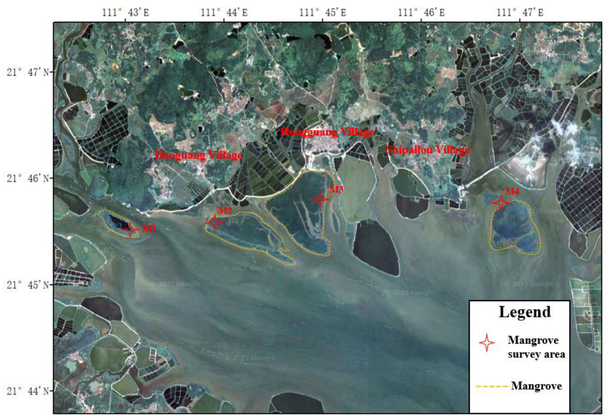
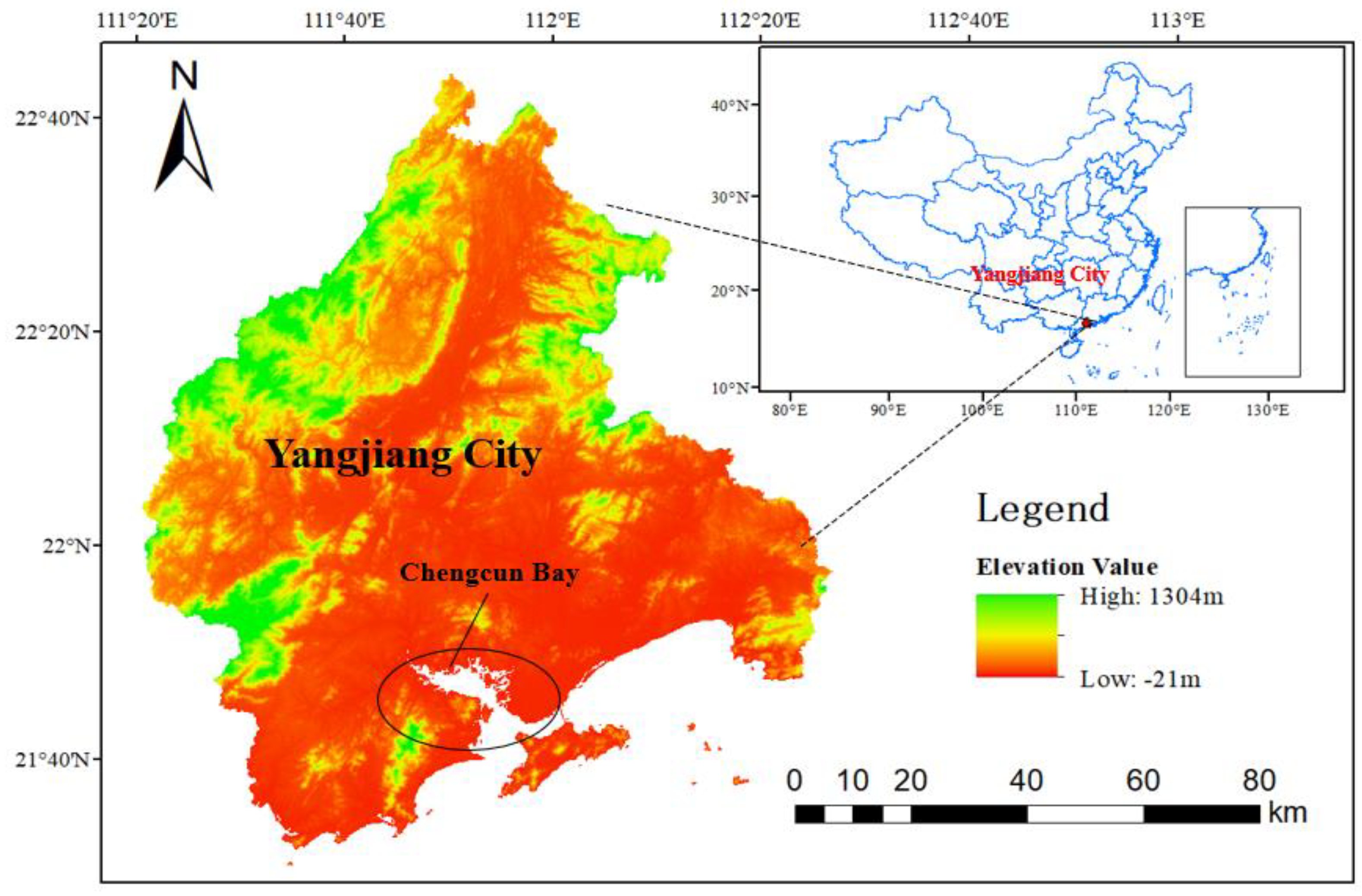
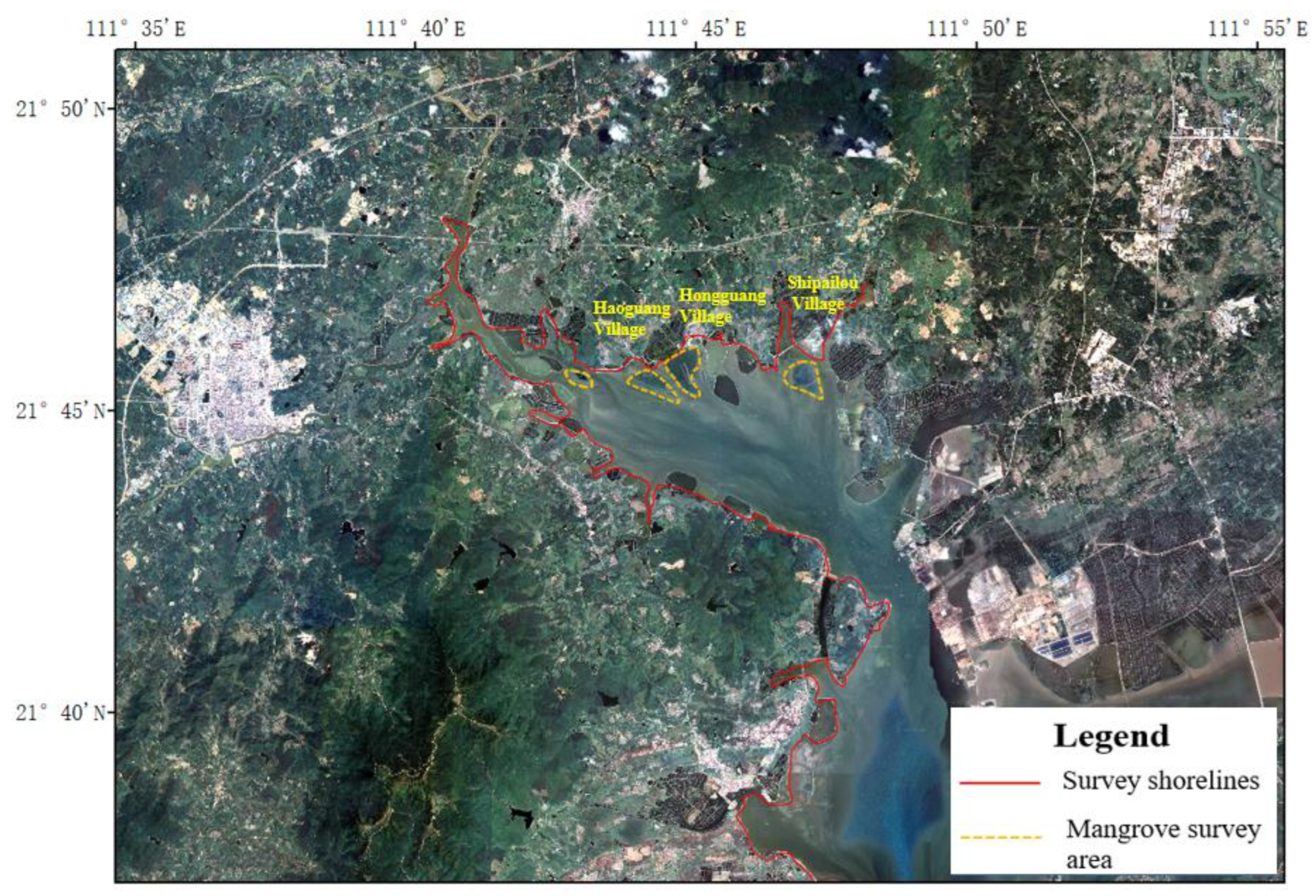
2.1. Survey Area
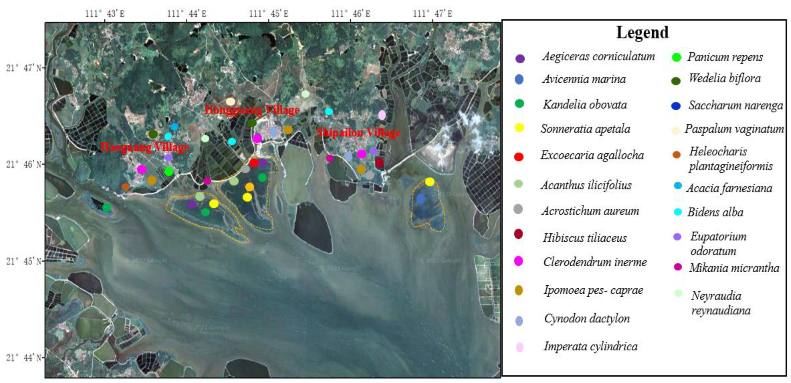
2.2. Survey Methods
3. Results
3.1. Plant Species Composition
3.2. Floristic Analysis
3.3. Characteristics of Plant Community Structure
3.4. Distribution Characteristics of Vegetation
4. Discussion
4.1. Factors Restricting Vegetation Growth and Development around Chengcun Bay
4.2. Suggestions for Coastal Vegetation Restoration around Chengcun Bay
5. Conclusions
Supplementary Materials
Author Contributions
Funding
Institutional Review Board Statement
Informed Consent Statement
Data Availability Statement
Acknowledgments
Conflicts of Interest
Appendix A

| Site | longitude | Latitude |
|---|---|---|
| M1-1 | 111°42′46.47″ | 21°45′41.99″ |
| M1-2 | 111°42′59.99″ | 21°45′35.90″ |
| M1-3 | 111°43′6.00″ | 21°45′30.95″ |
| M2-1 | 111°43′50.70″ | 21°45′49.80″ |
| M2-2 | 111°44′0.80″ | 21°45′24.76″ |
| M2-3 | 111°44′36.39″ | 21°45′12.99″ |
| M3-1 | 111°45′1.42″ | 21°46′3.27″ |
| M3-2 | 111°45′1.36″ | 21°45′48.88″ |
| M3-3 | 111°45′0.29″ | 21°45′32.85″ |
| M4-1 | 111°46′39.52″ | 21°45′53.57″ |
| M4-2 | 111°46′55.31″ | 21°45′48.61″ |
| M4-3 | 111°47′9.94″ | 21°45′29.00″ |
References
- Xu, X.; Jiang, H.; Guan, M.; Wang, L.; Huang, Y.; Jiang, Y.; Wang, A. Vegetation responses to extreme climatic indices in coastal China from 1986 to 2015. Sci. Total Environ. 2020, 744, 140784. [Google Scholar] [CrossRef] [PubMed]
- Fang, S.; Jia, X.; Qian, Q.; Cui, J.; Cagle, G.; Hou, A. Reclamation history and development intensity determine soil and vegetation characteristics on developed coasts. Sci. Total Environ. 2017, 586, 1263–1271. [Google Scholar] [CrossRef] [PubMed]
- Chen, X.; Huang, Y.; Yang, H.; Pan, L.; Perry, D.C.; Xu, P.; Tang, J.; You, W.; He, X.; Wen, Q. Restoring wetlands outside of the seawalls and to provide clean water habitat. Sci. Total Environ. 2020, 721, 137788. [Google Scholar] [CrossRef] [PubMed]
- Wu, Y.; Tang, G.; Gu, H.; Liu, Y.; Yang, M.; Sun, L. The variation of vegetation greenness and underlying mechanisms in Guangdong province of China during 2001-2013 based on MODIS data. Sci. Total Environ. 2019, 653, 536–546. [Google Scholar] [CrossRef] [PubMed]
- Liu, Y.; Liu, Y.; Li, J.; Sun, C.; Xu, W.; Zhao, B. Trajectory of coastal wetland vegetation in Xiangshan Bay, China, from image time series. Mar. Pollut. Bull. 2020, 160, 111697. [Google Scholar] [CrossRef] [PubMed]
- Xu, G.; Zhang, J.; Li, P.; Li, Z.; Lu, K.; Wang, X.; Wang, F.; Cheng, Y.; Wang, B. Vegetation restoration projects and their influence on runoff and sediment in China. Ecol. Indic. 2018, 95, 233–241. [Google Scholar] [CrossRef]
- de Langre, E. Effects of Wind on Plants. Annu. Rev. Fluid Mech. 2008, 40, 141–168. [Google Scholar] [CrossRef] [Green Version]
- Wang, B.; Xu, G.; Li, P.; Li, Z.; Zhang, Y.; Cheng, Y.; Jia, L.; Zhang, J. Vegetation dynamics and their relationships with climatic factors in the Qinling Mountains of China. Ecol. Indic. 2020, 108, 105719. [Google Scholar] [CrossRef]
- Yuan, Y.; Bao, A.; Liu, T.; Zheng, G.; Jiang, L.; Guo, H.; Jiang, P.; Yu, T.; De Maeyer, P. Assessing vegetation stability to climate variability in Central Asia. J. Environ. Manag. 2021, 298, 113330. [Google Scholar] [CrossRef]
- Han, Z.; Huang, S.; Huang, Q.; Bai, Q.; Leng, G.; Wang, H.; Zhao, J.; Wei, X.; Zheng, X. Effects of vegetation restoration on groundwater drought in the Loess Plateau, China. J. Hydrol. 2020, 591, 125566. [Google Scholar] [CrossRef]
- Yan, W.; Wang, H.; Jiang, C.; Jin, S.; Ai, J.; Sun, O.J. Satellite view of vegetation dynamics and drivers over southwestern China. Ecol. Indic. 2021, 130, 108074. [Google Scholar] [CrossRef]
- Chen, Y.; Huang, B.; Zeng, H. How does urbanization affect vegetation productivity in the coastal cities of eastern China? Sci. Total Environ. 2022, 811, 152356. [Google Scholar] [CrossRef] [PubMed]
- Fan, H.; Xu, L.; Wang, X.; Jiang, J.; Feng, W.; You, H. Relationship Between Vegetation Community Distribution Patterns and Environmental Factors in Typical Wetlands of Poyang Lake, China. Wetlands 2017, 39, 75–87. [Google Scholar] [CrossRef]
- Fu, G.; Xu, X.; Qiu, X.; Xu, G.; Shang, W.; Yang, X.; Zhao, P.; Chai, C.; Hu, X.; Zhang, Y.; et al. Wind tunnel study of the effect of planting Haloxylon ammodendron on aeolian sediment transport. Biosyst. Eng. 2021, 208, 234–245. [Google Scholar] [CrossRef]
- Yang, Y.-S.; Wang, Z.-C.; Chen, L.-L.; An, S.-Q.; Zhu, H.-L. Improving effect of vegetation on the coastal salt marshes in Yancheng, Eastern China: A five-year observation (2013–2017). Acta Ecol. Sin. 2020, 41, 402–409. [Google Scholar] [CrossRef]
- Hao, J.; Xu, G.; Luo, L.; Zhang, Z.; Yang, H.; Li, H. Quantifying the relative contribution of natural and human factors to vegetation coverage variation in coastal wetlands in China. Catena 2020, 188, 104429. [Google Scholar] [CrossRef]
- Jiang, H.; Xu, X.; Guan, M.; Wang, L.; Huang, Y.; Jiang, Y. Determining the contributions of climate change and human activities to vegetation dynamics in agro-pastural transitional zone of northern China from 2000 to 2015. Sci. Total Environ. 2020, 718, 134871. [Google Scholar] [CrossRef]
- Wang, T.; Xiao, L.; Lu, H.; Lu, S.; Li, J.; Guo, X.; Zhao, X. Nitrogen removal from summer to winter in a field pilot-scale multistage constructed wetland-pond system. J. Environ. Sci. 2022, 111, 249–262. [Google Scholar] [CrossRef]
- Wang, H.; Su, X.; Su, J.; Zhu, Y.; Ding, K. Profiling the antibiotic resistome in soils between pristine and human-affected sites on the Tibetan Plateau. J. Environ. Sci. 2022, 111, 442–451. [Google Scholar] [CrossRef]
- Dibaba, A.; Soromessa, T.; Warkineh, B. Plant community analysis along environmental gradients in moist afromontane forest of Gerba Dima, South-western Ethiopia. BMC Ecol. Evol. 2022, 22, 12. [Google Scholar] [CrossRef]
- Taddeo, S.; Dronova, I.; Depsky, N. Spectral vegetation indices of wetland greenness: Responses to vegetation structure, composition, and spatial distribution. Remote Sens. Environ. 2019, 234, 111467. [Google Scholar] [CrossRef]
- Taddeo, S.; Dronova, I. Indicators of vegetation development in restored wetlands. Ecol. Indic. 2018, 94, 454–467. [Google Scholar] [CrossRef]
- Dybiec, J.M.; Albert, D.A.; Danz, N.P.; Wilcox, D.A.; Uzarski, D.G. Development of a preliminary vegetation-based indicator of ecosystem health for coastal wetlands of the Laurentian Great Lakes. Ecol. Indic. 2020, 119, 106768. [Google Scholar] [CrossRef]
- McCrackin, M.L.; Jones, H.P.; Jones, P.C.; Moreno-Mateos, D. Recovery of lakes and coastal marine ecosystems from eutrophication: A global meta-analysis. Limnol. Oceanogr. 2016, 62, 507–518. [Google Scholar] [CrossRef]
- Xu, X.; Zou, X.; Cao, L.; Zhamangulova, N.; Zhao, Y.; Tang, D.; Liu, D. Seasonal and spatial dynamics of greenhouse gas emissions under various vegetation covers in a coastal saline wetland in southeast China. Ecol. Eng. 2014, 73, 469–477. [Google Scholar] [CrossRef]
- Chang, C.-W.; Mori, N. Green infrastructure for the reduction of coastal disasters: A review of the protective role of coastal forests against tsunami, storm surge, and wind waves. Coast. Eng. J. 2021, 63, 370–385. [Google Scholar] [CrossRef]
- Li, J.; Chen, H.; Guo, K.; Li, W.; Feng, X.; Liu, X. Changes in soil properties induced by pioneer vegetation patches in coastal ecosystem. Catena 2021, 204, 105393. [Google Scholar] [CrossRef]
- Zhao, S.; Zhang, Q.; Liu, M.; Zhou, H.; Ma, C.; Wang, P. Regulation of Plant Responses to Salt Stress. Int. J. Mol. Sci. 2021, 22, 4609. [Google Scholar] [CrossRef]
- He, B.; Cai, Y.; Ran, W.; Jiang, H. Spatial and seasonal variations of soil salinity following vegetation restoration in coastal saline land in eastern China. Catena 2014, 118, 147–153. [Google Scholar] [CrossRef]
- Zhang, X.; Zhang, Z.; Wang, W.; Fang, W.T.; Chiang, Y.T.; Liu, X.; Ju, H. Vegetation successions of coastal wetlands in southern Laizhou Bay, Bohai Sea, northern China, influenced by the changes in relative surface elevation and soil salinity. J. Environ. Manag. 2021, 293, 112964. [Google Scholar] [CrossRef]
- Silliman, B.R.; He, Q.; Angelini, C.; Smith, C.S.; Kirwan, M.L.; Daleo, P.; Renzi, J.J.; Butler, J.; Osborne, T.Z.; Nifong, J.C.; et al. Field Experiments and Meta-analysis Reveal Wetland Vegetation as a Crucial Element in the Coastal Protection Paradigm. Curr. Biol. 2019, 29, 1800–1806.e1803. [Google Scholar] [CrossRef] [PubMed]
- Durango-Cordero, J.; Satyanarayana, B.; Cheung-Wai Chan, J.; Bogaert, J.; Dahdouh-Guebas, F. Distinguishing Original and Non-Original Stands at the Zhanjiang Mangrove National Nature Reserve (P.R. China): Remote Sensing and GIS for Conservation and Ecological Research. Remote Sens. 2021, 13, 2781. [Google Scholar] [CrossRef]
- Hao, J.; Chen, X.; Zhang, Z.; Gao, Y.; Li, L.; Li, H. Quantifying the temporal-spatial scale dependence of the driving mechanisms underlying vegetation coverage in coastal wetlands. Catena 2021, 204, 105435. [Google Scholar] [CrossRef]
- Liu, H.; Xu, H.; Wu, Y.; Ai, Z.; Zhang, J.; Liu, G.; Xue, S. Effects of natural vegetation restoration on dissolved organic matter (DOM) biodegradability and its temperature sensitivity. Water Res. 2021, 191, 116792. [Google Scholar] [CrossRef]
- Wan, J.-Z.; Yu, J.-H.; Yin, G.-J.; Song, Z.-M.; Wei, D.-X.; Wang, C.-J. Effects of soil properties on the spatial distribution of forest vegetation across China. Glob. Ecol. Conserv. 2019, 18, e00635. [Google Scholar] [CrossRef]
- Weidlich, E.W.A.; Flórido, F.G.; Sorrini, T.B.; Brancalion, P.H.S.; Peralta, G. Controlling invasive plant species in ecological restoration: A global review. J. Appl. Ecol. 2020, 57, 1806–1817. [Google Scholar] [CrossRef]
- Feng, J.; Zhou, J.; Wang, L.; Cui, X.; Ning, C.; Wu, H.; Zhu, X.; Lin, G. Effects of short-term invasion of Spartina alterniflora and the subsequent restoration of native mangroves on the soil organic carbon, nitrogen and phosphorus stock. Chemosphere 2017, 184, 774–783. [Google Scholar] [CrossRef]
- Zhang, D.; Ge, W.; Zhang, Y. Evaluating the vegetation restoration sustainability of ecological projects: A case study of Wuqi County in China. J. Clean. Prod. 2020, 264, 121751. [Google Scholar] [CrossRef]
| Taxonomic Groups | Families | Genus | Species |
|---|---|---|---|
| Fern | 5 | 5 | 5 |
| Gymnosperms | 0 | 0 | 0 |
| Angiosperms | 35 | 83 | 97 |
| Dicotyledons | 31 | 60 | 72 |
| Monocotyledons | 4 | 23 | 25 |
| Total | 40 | 88 | 102 |
| Areal Types and Variations | Number of Genera | Proportion in Total Genera (%) |
|---|---|---|
| 11 | 13.25 |
| 43 | 51.81 |
| 4 | 4.82 |
| 10 | 12.05 |
| 4 | 4.82 |
| 5 | 6.02 |
| 4 | 4.82 |
| 2 | 2.41 |
| 0 | 0 |
| 0 | 0 |
| 0 | 0 |
| 0 | 0 |
| 0 | 0 |
| 0 | 0 |
| 0 | 0 |
| Total | 83 | 100.00 |
Publisher’s Note: MDPI stays neutral with regard to jurisdictional claims in published maps and institutional affiliations. |
© 2022 by the authors. Licensee MDPI, Basel, Switzerland. This article is an open access article distributed under the terms and conditions of the Creative Commons Attribution (CC BY) license (https://creativecommons.org/licenses/by/4.0/).
Share and Cite
Chen, S.; Sun, Y.; Tang, K.; Zhang, F.; Ding, W.; Wang, A. Distribution Characteristics and Restoration Application of Vegetation in Chengcun Bay Surrounding Areas of Yangjiang City. Int. J. Environ. Res. Public Health 2022, 19, 10399. https://doi.org/10.3390/ijerph191610399
Chen S, Sun Y, Tang K, Zhang F, Ding W, Wang A. Distribution Characteristics and Restoration Application of Vegetation in Chengcun Bay Surrounding Areas of Yangjiang City. International Journal of Environmental Research and Public Health. 2022; 19(16):10399. https://doi.org/10.3390/ijerph191610399
Chicago/Turabian StyleChen, Shan, Yuanmin Sun, Kunxian Tang, Fei Zhang, Weilun Ding, and Ao Wang. 2022. "Distribution Characteristics and Restoration Application of Vegetation in Chengcun Bay Surrounding Areas of Yangjiang City" International Journal of Environmental Research and Public Health 19, no. 16: 10399. https://doi.org/10.3390/ijerph191610399
APA StyleChen, S., Sun, Y., Tang, K., Zhang, F., Ding, W., & Wang, A. (2022). Distribution Characteristics and Restoration Application of Vegetation in Chengcun Bay Surrounding Areas of Yangjiang City. International Journal of Environmental Research and Public Health, 19(16), 10399. https://doi.org/10.3390/ijerph191610399