Evaluation and Optimization of Walkability of Children’s School Travel Road for Accessibility and Safety Improvement
Abstract
:1. Introduction
2. Materials and Methods
2.1. Research Object
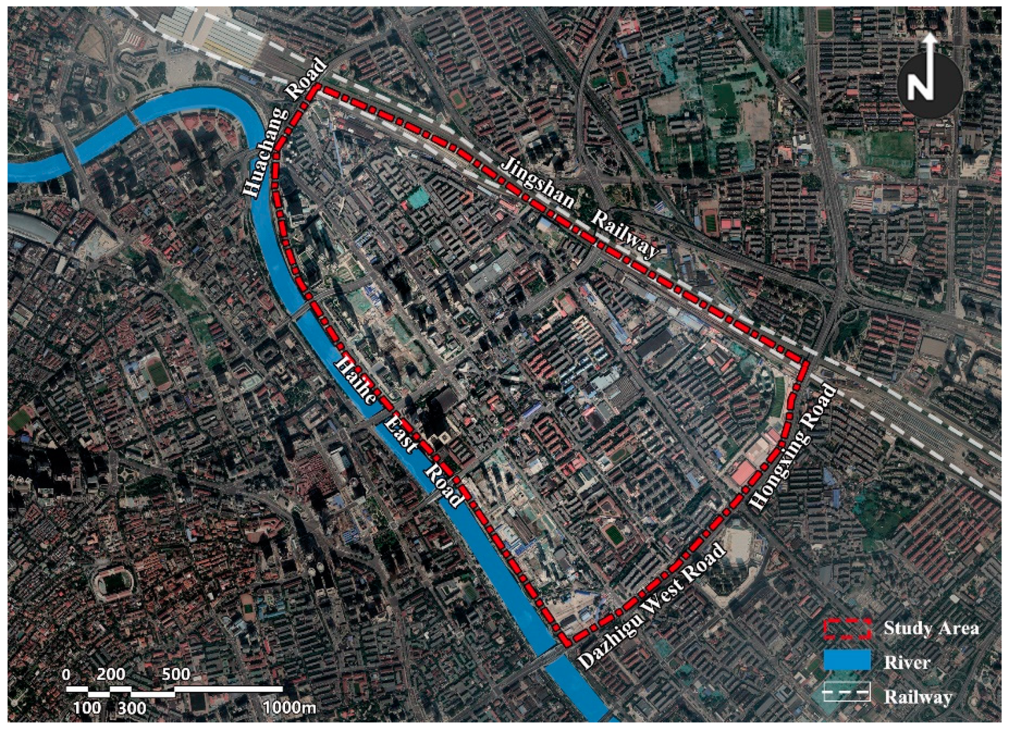
2.2. Study Area
2.3. Research Methods
2.3.1. Data Base and Network Construction
2.3.2. Index System Construction
2.3.3. Evaluation Model Construction
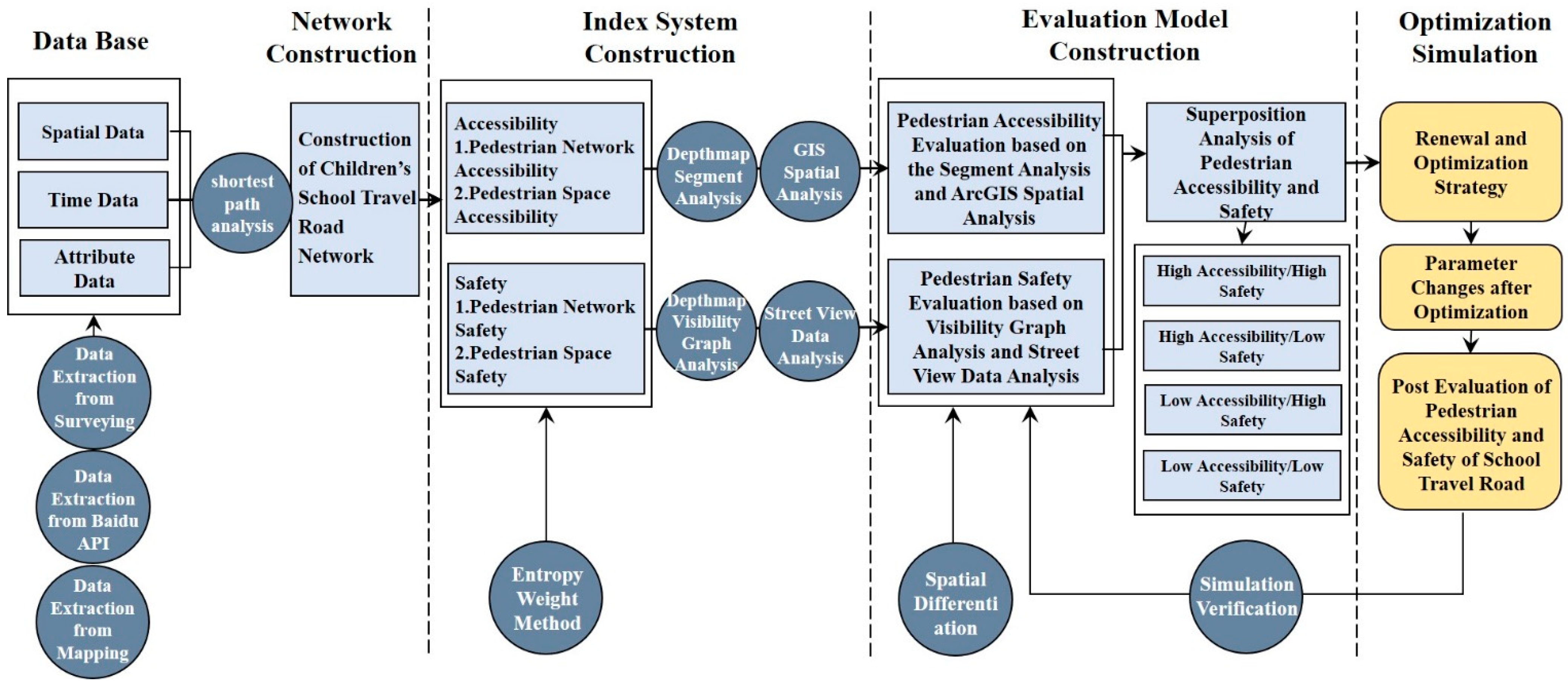
2.4. Technical Route
3. Results and Discussion
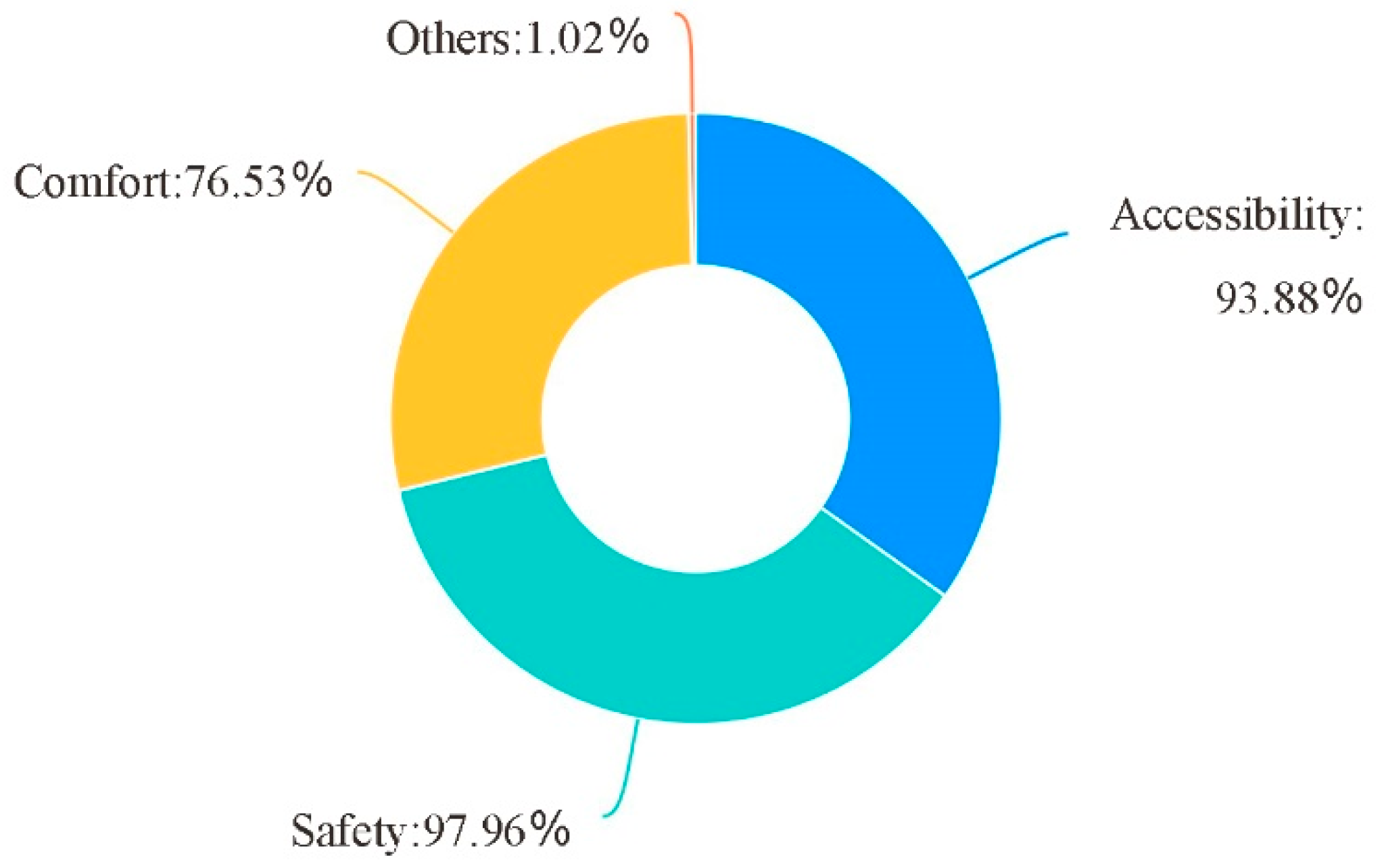
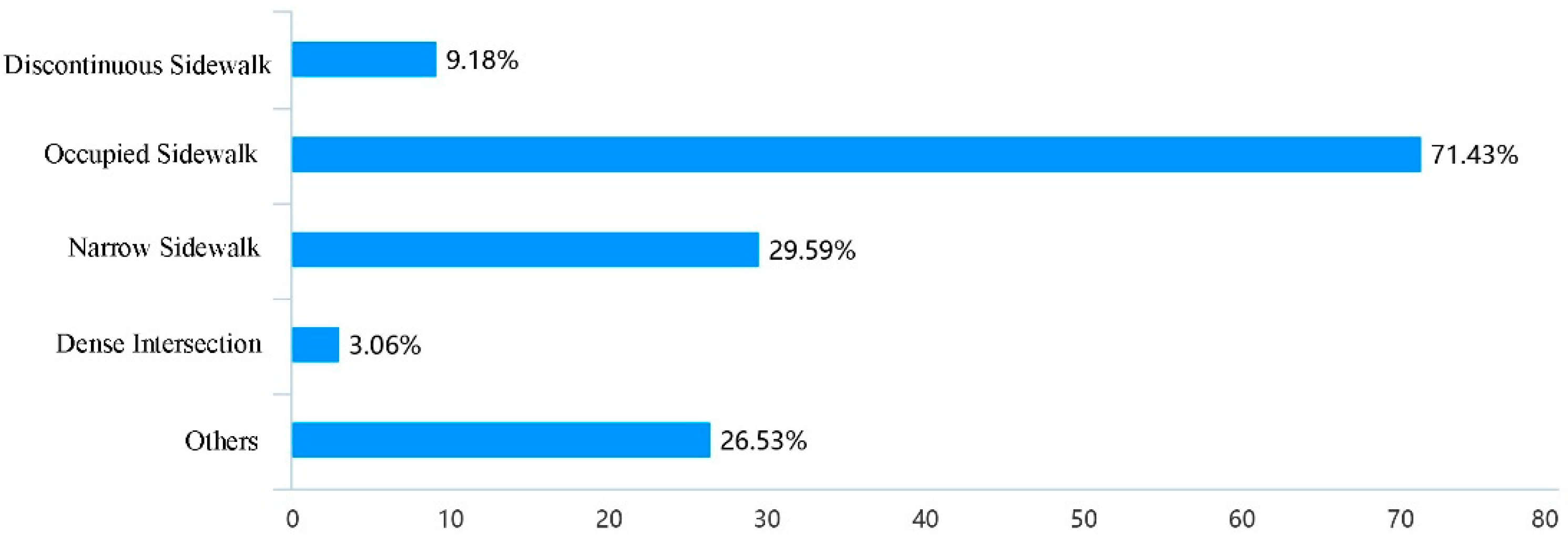
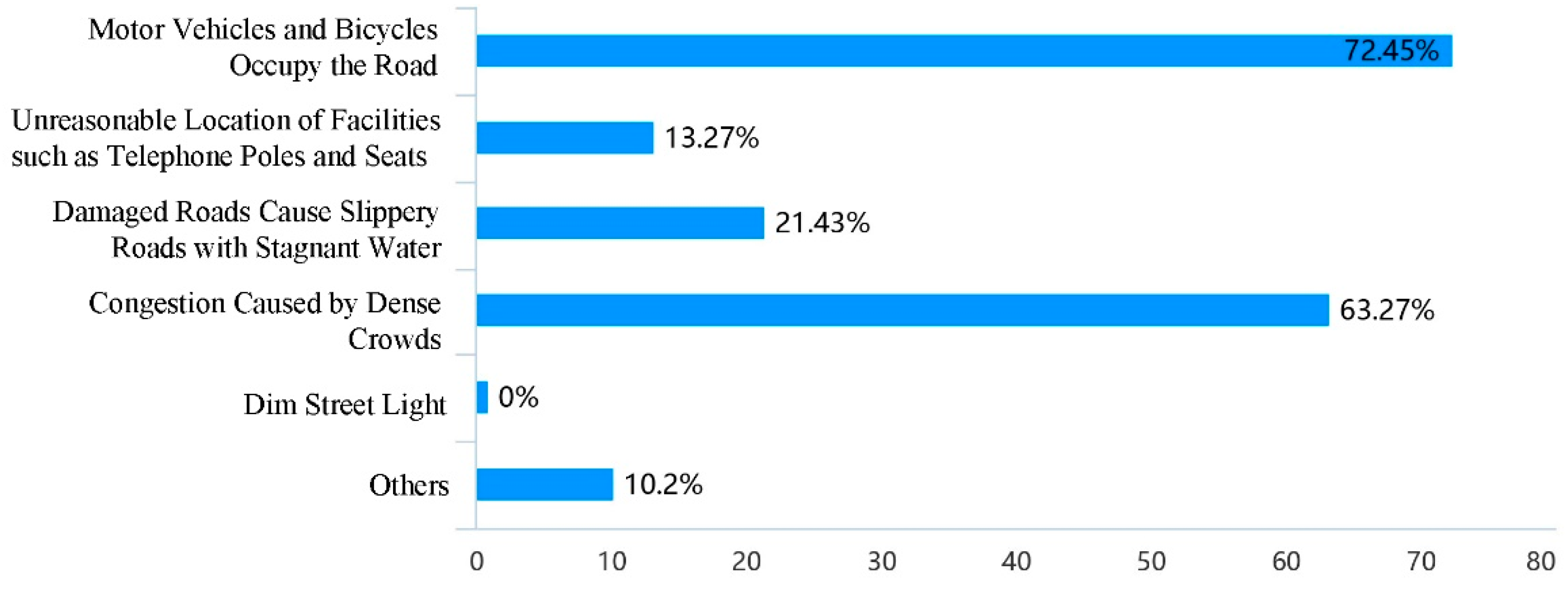
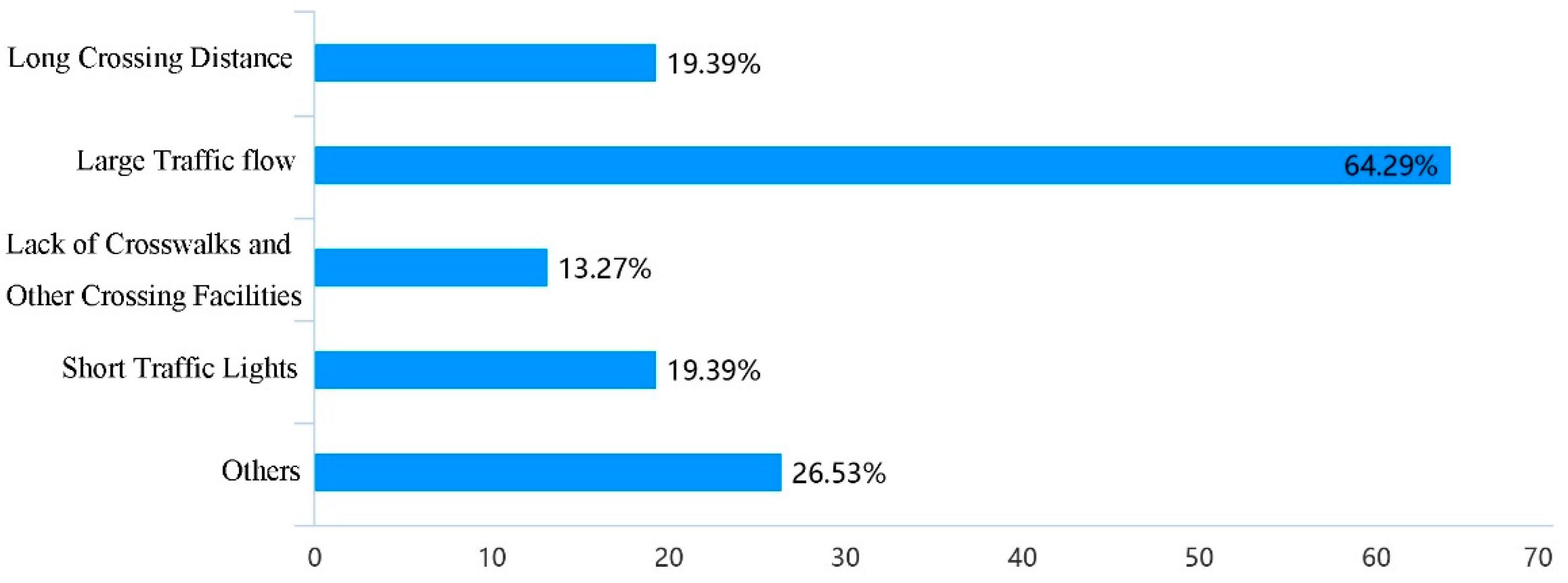
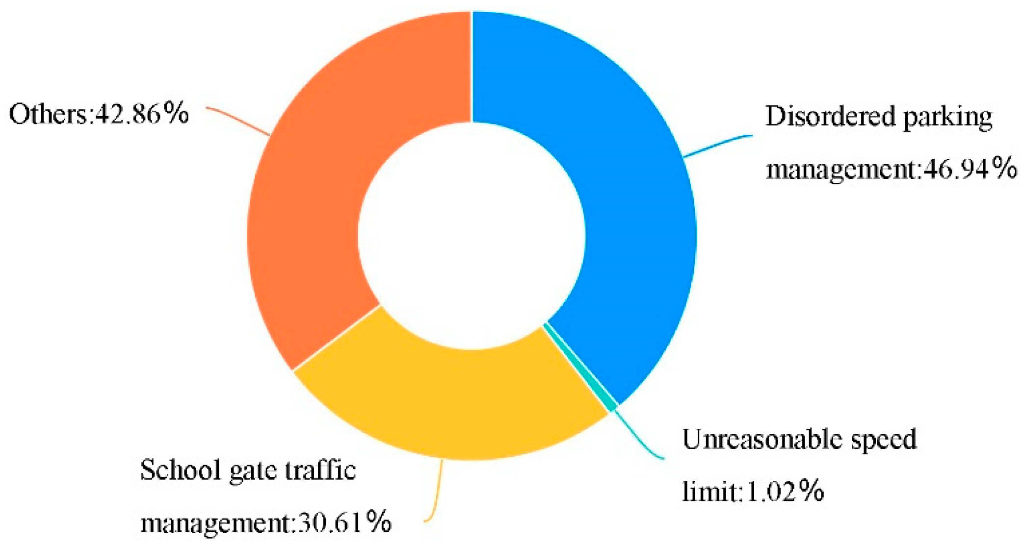
3.1. Analysis of Children’s School Travel Needs and Problems Based on Field Investigation
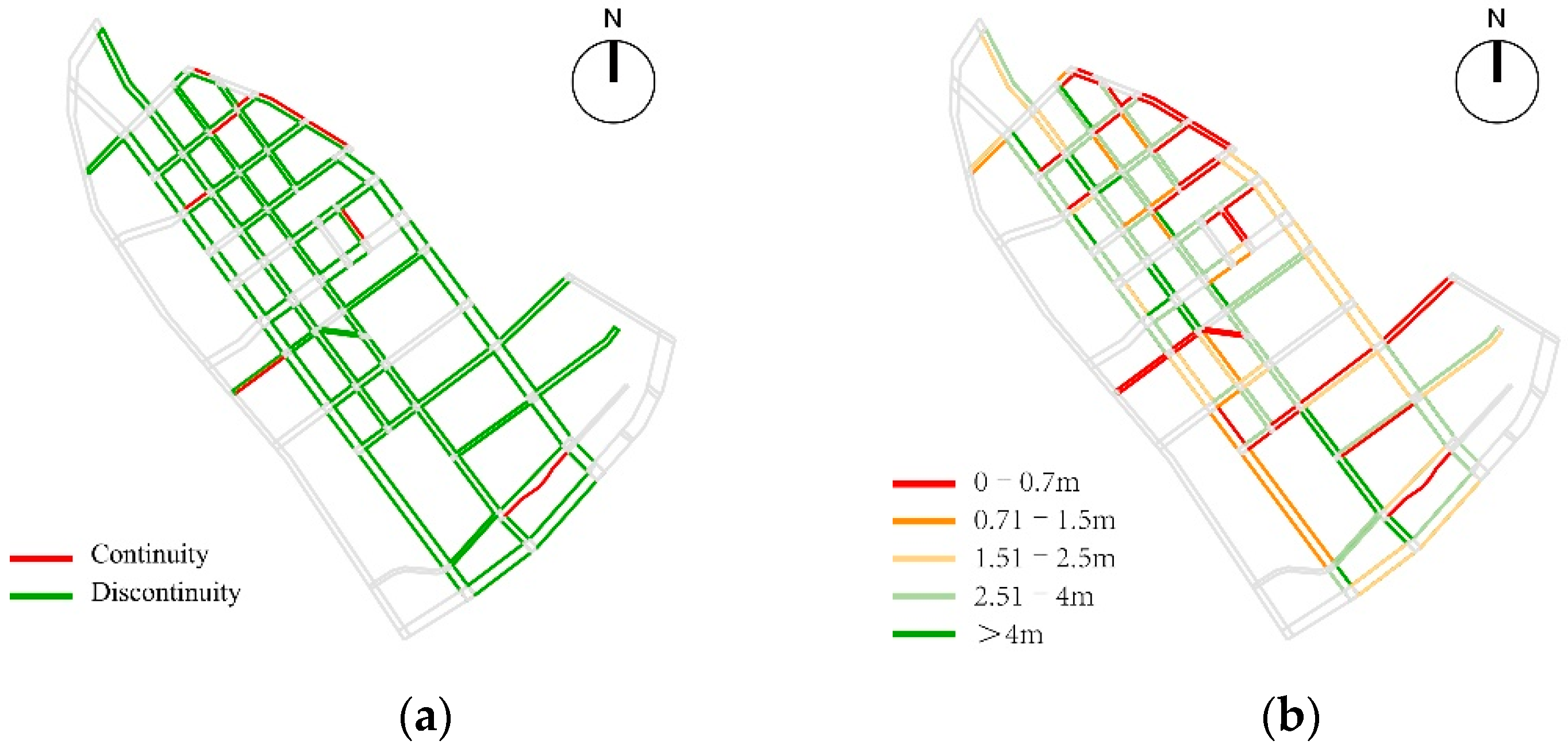
3.2. Pedestrian Accessibility Evaluation Based on the Segment Analysis and ArcGIS Spatial Analysis
3.3. Pedestrian Safety Evaluation Based on Visibility Graph Analysis and Street View Data Analysis
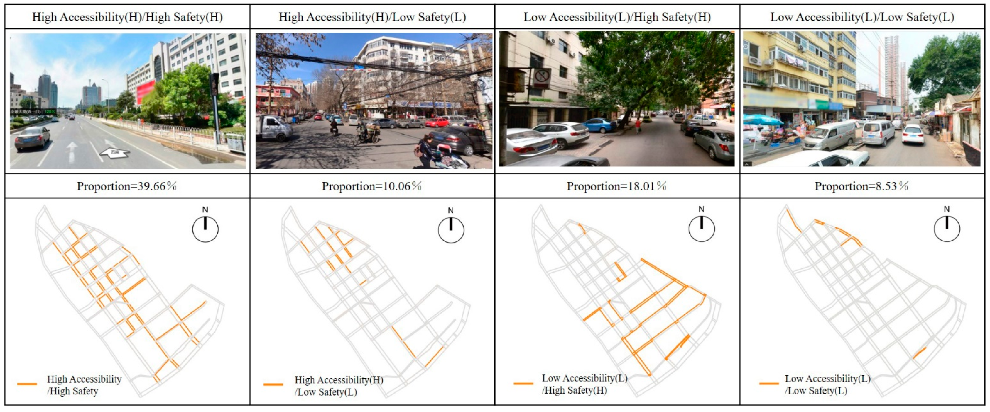
3.4. Comprehensive Evaluation on Pedestrian Accessibility and Safety of School Travel Road
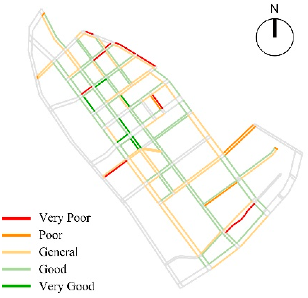
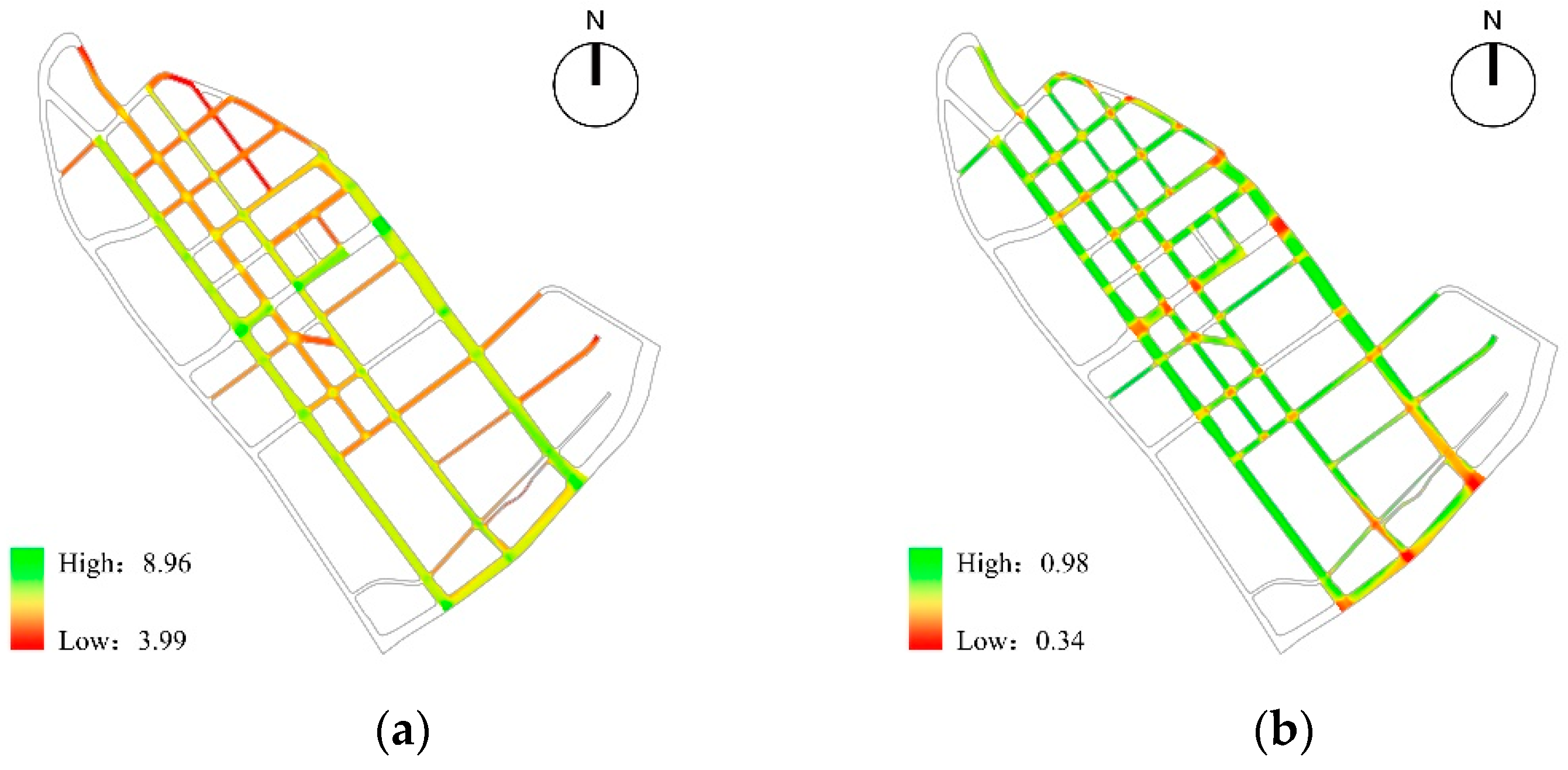
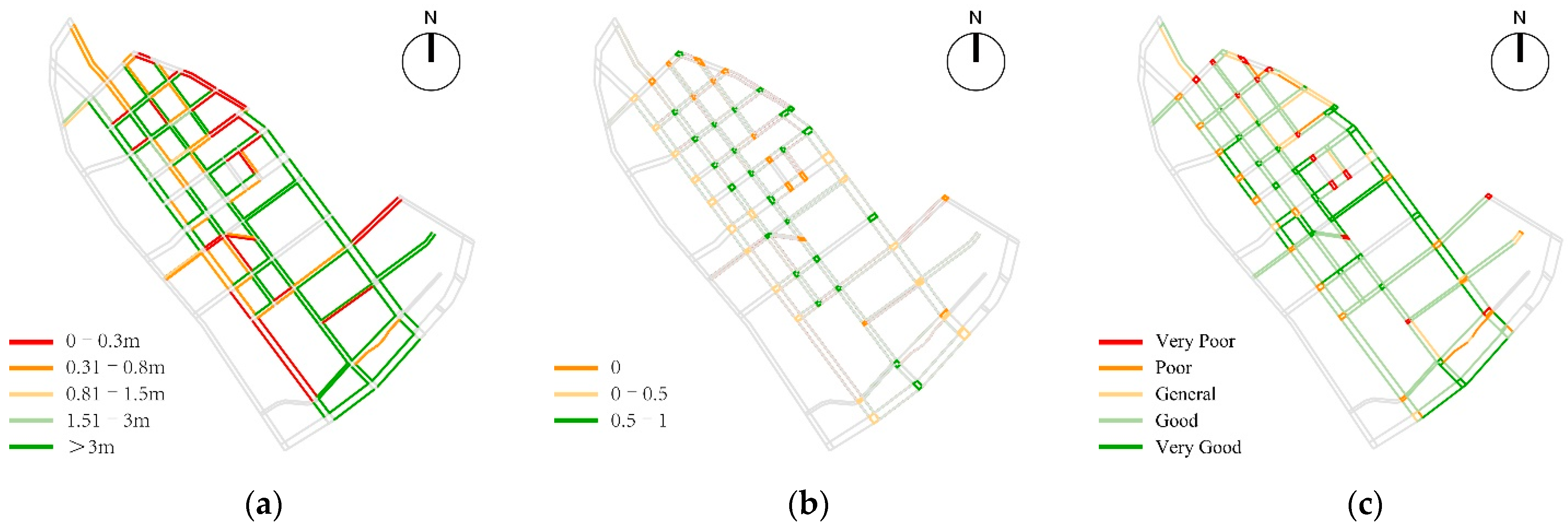
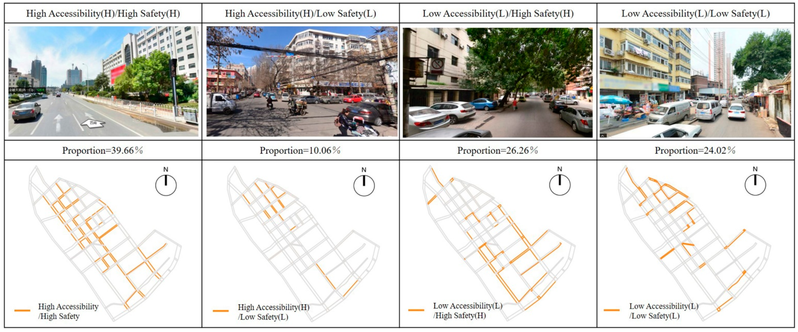
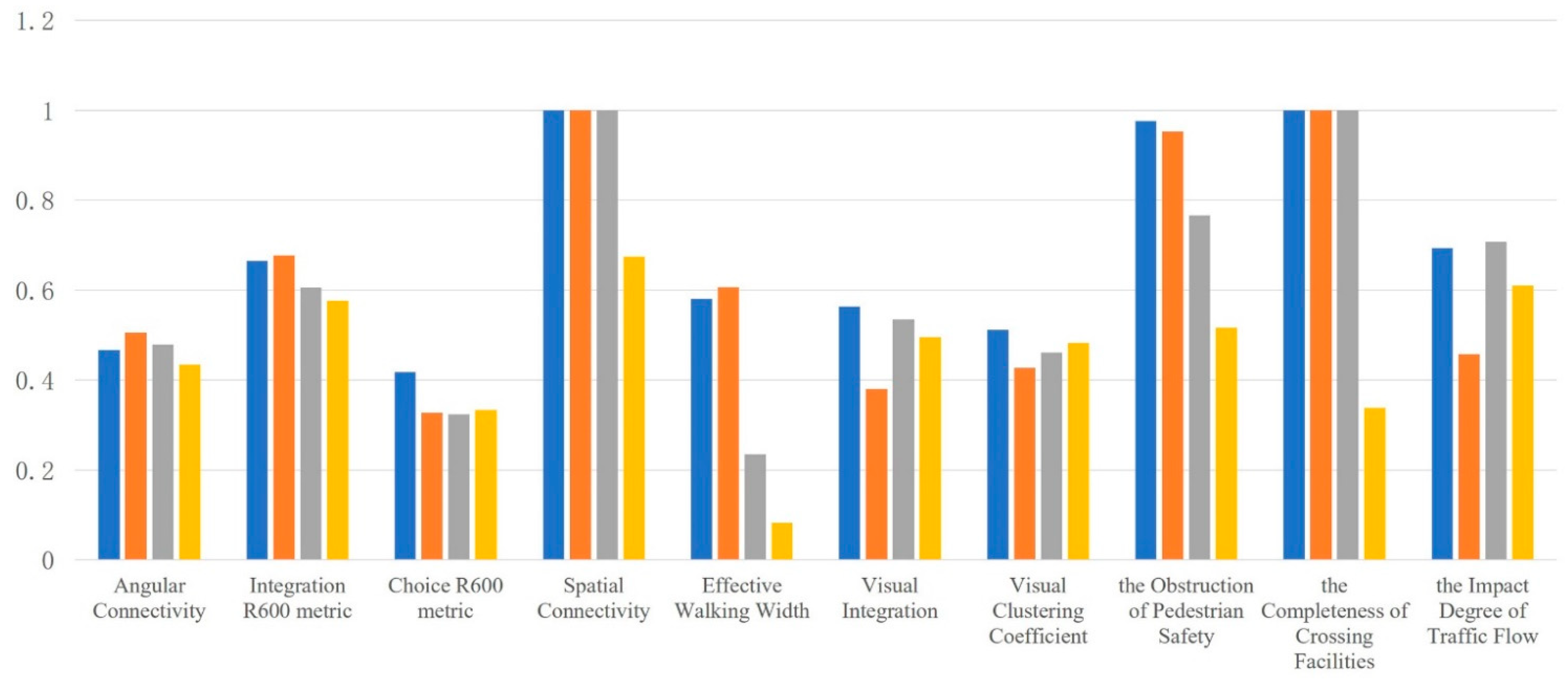
- High Accessibility/High Safety: This kind of school travel roads had higher scores of pedestrian accessibility and pedestrian safety, and had better space potential. In the study area, such road sections were mostly concentrated in the north section of Liuwei Road, north section of Qiwei Road, south section of Bawei Road, Qijing Road, Bajing Road, east section of Shijing Road, east section of Shierjing Road, North Shiwujing road and south section of Jintang road.
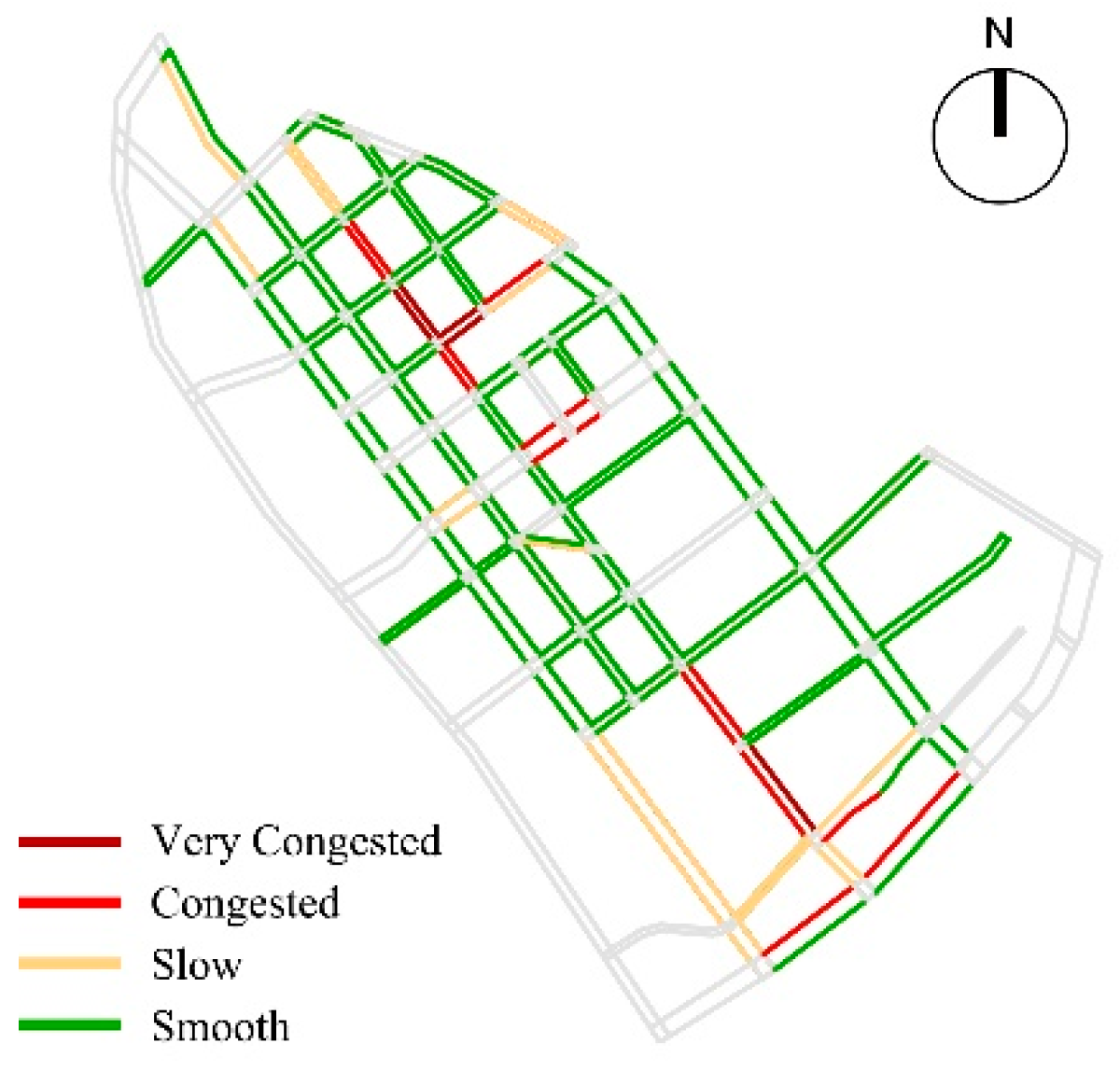
- High Accessibility/Low Safety: Such road sections were mostly concentrated in the northern section of Bawei Road, the northern section of Jiuwei Road, and some sections of Liuwei Road, Qiwei Road, Qijing Road, and Bajing Road, which were generally the main roads connecting the area. The road network structure was generally accessible and had a relatively continuous walking space. However, due to the problems of motor vehicle parking and lack of pedestrian crossing facilities, it interfered with children’s pedestrian school travel behavior and had low pedestrian safety.
- Low Accessibility/High Safety: Such road sections were mostly concentrated in the road sections with higher road grades, such as the southern section of Liuwei Road, the northern section of Jintang Road, the eastern section of Shisijing Road, the Beiwujing Road, and the Shifivejing Road, etc. On the one hand, due to the influence of discontinuous sidewalk and blocked T-junction, the accessibility of pedestrian network was poor. On the other hand, due to the influence of parking occupation, municipal facilities occupation and commercial layout, the sidewalks were relatively narrow in width and poor in accessibility.
- Low Accessibility/Low Safety: Such sections were mainly concentrated in the north section of Qiwei Road, the east section of Jiujing Road, the west section of Shierjing Road, Xijin Road and Beichang Road. Affected by unreasonable road network structure, imperfect street facilities, and inadequate planning and management, this type of road needed to be improved in terms of pedestrian accessibility and safety, which needed to be focused on in the follow-up regeneration and reconstruction.
4. Conclusions and Prospect
4.1. Conclusions
4.2. Optimization Strategy
4.2.1. Pedestrian Network: Optimize the Pedestrian Network of School Travel Road to Meet the Requirements of Pedestrian Accessibility
4.2.2. Pedestrian Space: Intensive Use of Street Space to Achieve Spatial Integration of School Travel Road
4.2.3. Important Nodes: Refined Design of Intersection and School Front Space to Achieve Traffic Calm and Stability
4.2.4. Fine Governance: Coordinate Traffic Management, and Implement Traffic Control on Special Sections during School Hours
4.3. Simulation Verification
4.4. Research Prospect
Author Contributions
Funding
Institutional Review Board Statement
Informed Consent Statement
Data Availability Statement
Conflicts of Interest
References
- UNICEF. Child Friendly Cities and Communities Handbook. 2018. Available online: https://www.unicef.org/eap/reports/child-friendly-cities-andcommunities-handbook (accessed on 1 October 2020).
- UNICEF. Child Friendly Cities Initiative Handbook. 2018. Available online: https://www.unicef.org/media/56291/file/%E5%84%BF%E7%AB%A5%E5%8F%8B%E5%A5%BD%E5%9E%8B%E5%9F%8E%E5%B8%82%E8%A7%84%E5%88%92%E6%89%8B%E5%86%8C.pdf (accessed on 1 October 2020).
- UNICEF. The Issues from Child Health Initiative—Child Health and Mobility. 2020. Available online: https://www.childhealthinitiative.org/about/the-issues (accessed on 1 October 2020).
- Pedestrian and Bicycle Information Center (PBIC). Safe Routes to School Online Guide. Available online: http://www.walkingschoolbus.org/WalkingSchoolBus_pdf.pdf (accessed on 1 October 2020).
- New Zealand Government. Walking School Bus Program. Available online: https://at.govt.nz/cycling-walking/school-travel/walking-school-bus (accessed on 1 October 2020).
- Stadt Bad Wünnenberg. Gelbe Füße Machen Wege Sicher. Available online: https://www.bad-wuennenberg.de/rathaus/Gelbe-Fuesse-Bleiwaesche.php?sp-view=print# (accessed on 1 October 2020).
- He, L.L.; Lin, L. The Impacts of School Neighborhood Built Environment on School-age Children’s School Commuting: A Case Study of Shanghai. Shanghai Urban Plan. Rev. 2017, 3, 30–36. [Google Scholar]
- Han, J.; Cheng, G.Z.; Li, H.Q. Characteristics and Management Strategies for Commuting Trips of Primary School Students. Urban Transp. China 2011, 9, 74–79. [Google Scholar] [CrossRef]
- Wang, X.; Chen, X.J.; Jiao, J. Accessibility of Urban Primary Schools Based on Family Travel Behavior: A Case of Xi, An. City Plan. Rev. 2015, 39, 64–72. [Google Scholar]
- Liu, J.X.; Zhou, J.P.; Xiao, L.Z.; Yang, L.C. Effects of the Built Environment on Pedestrian Communing to Work and School: The Hong Kong Case, China. Prog. Geogr. 2019, 38, 807–817. [Google Scholar]
- Jiang, W.Z.; Qiao, G.M.; Shao, L.X.; Sun, W.W. Study on the Accessibility of Urban Residents to School Based on Improved Potential Model—A Case Study of Haishu District, Ningbo City. Product. Res. 2015, 5, 67–71. [Google Scholar] [CrossRef]
- Wu, F.W.; Chen, M.Y. The Evaluation and Improvement Strategy of the Way to Elementary School from the Perspective of Children. Urban Dev. Stud. 2020, 27, 20–27. [Google Scholar]
- Han, Z.Y.; Fei, C.Y.; Chen, Y.L.; Jiang, Y. Safety Environment Assessment of School Route with New Technologies: A Case Study of Beijing. Urban Transp. China 2020, 18, 58–66. [Google Scholar] [CrossRef]
- Ministry of Housing and Urban-Rural Development of the People’s Republic of China. Design Code for Primary and Secondary Schools (GB50099-2011). 2011. Available online: https://gf.1190119.com/m/list-269.htm (accessed on 1 October 2020).
- Ministry of Housing and Urban-Rural Development of the People’s Republic of China. Design Code for Urban Road Engineering (CJJ37-2016). 2016. Available online: http://www.jianbiaoku.com/webarbs/book/304/2958159.shtml (accessed on 1 October 2020).
- Shanghai Municipal Planning and Land Resources Administration. Shanghai Street Design Guidelines. 14 July 2017. Available online: https://www.efchina.org/Attachments/Report/report-20170714-2/report-20170714-2/at_download/file (accessed on 1 October 2020).
- Urban Design Guidelines for Beijing Street Renewal and Governance. Beijing Municipal Institute of City Planning &Design. September 2019. Available online: https://max.book118.com/html/2019/1030/5224023031002144.shtm (accessed on 1 October 2020).
- Li, Y.Y. The Research of the Activity Space for the Children of Chengdu City Park; Sichuan Agricultural University: Yaan, China, 2016; pp. 4–12. [Google Scholar]
- Jiang, L.; Pan, M.S. Research on Small-scale Design of Outdoor Activity Space for Children: Reference from Foreign Children’s Outdoor Activity Places. Huazhong Archit. 2015, 8, 69–72. [Google Scholar] [CrossRef]
- Xiao, W.M. Research on Traffic Improvement Strategies around Child-Friendly Schools. In Proceedings of the 2018 Annual Conference of China Urban Transport Planning, Beijing, China, 5–8 July 2018; pp. 1386–1397. [Google Scholar]
- Han, L. Research on Children’s Outdoor Activity Space Design Based on Behavioral Psychology—A Case Study of Handan City; Hebei University of Engineering: Handan, China, 2017; pp. 9–20. [Google Scholar]
- Fan, H.R.; He, J.L. Study on the Slow and Steady Planning of Primary School District. In Proceedings of the 2018 Annual Conference of China Urban Transport Planning, Beijing, China, 5–8 July 2018; pp. 891–899. [Google Scholar]
- Yu, D.Q.; Ge, D.J. Children’s Nature and Children Education. J. Northeast. Norm. Univ. (Philos. Soc. Sci.) 2016, 4, 152–156. [Google Scholar] [CrossRef]
- Hothersal, D. History of Psychology, 4th ed.; The People’s Posts and Telecommunications Press: Beijing, China, 2011; pp. 507–508. [Google Scholar]
- Mitra, R. Independent mobility and mode choice for school transportation: A review and framework for future research. Transp. Rev. 2013, 33, 21–43. [Google Scholar] [CrossRef]
- Battista, G.A.; Manaugh, K. Stores and mores: Toward socializing walkability. J. Transp. Geogr. 2018, 67, 53–60. [Google Scholar] [CrossRef]
- UNICEF. Convention on the Rights of the Child. 1989. Available online: https://www.un.org/zh/documents/treaty/files/A-RES-44-25.shtml (accessed on 1 October 2020).
- Xue, X.D. Pediatrics; People’s Medical Publishing House: Beijing, China, 2005. [Google Scholar]
- Sun, X.M. Discussion on Japan’s Two Times “Traffic War”. Hist. Teach. 2019, 7, 43–50. [Google Scholar]
- The National People’s Congress of the People’s Republic of China. Compulsory Education Law of the People’s Republic of China. June 2006. Available online: http://www.npc.gov.cn/npc/c30834/201901/21b0be5b97e54c5088bff17903853a0d.shtml (accessed on 1 October 2020).
- Ministry of Education of the People’s Republic of China. Notice of the General Office of the Ministry of Education on Further Improving the Work of Exempting Compulsory Education in Key Big Cities from Examination and Entering Schools Nearby. 29 January 2014. Available online: http://old.moe.gov.cn//publicfiles/business/htmlfiles/moe/s7966/201402/164088.html (accessed on 1 October 2020).
- Ministry of Housing and Urban-Rural Development of the People’s Republic of China. Urban Residential Area Planning and Design Standard (GB50180-2018). 2018. Available online: http://www.moe.gov.cn/jyb_xwfb/xw_zt/moe_357/jyzt_2019n/2019_zt13/zcwj/201906/W020190606322674731563.pdf (accessed on 1 October 2020).
- Sullivan, D. Spatial Network Analysis; Springer: Berlin/Heidelberg, Germany, 2014; pp. 1253–1273. [Google Scholar]
- Wu, C.C.; Chen, D.W. Safety Evaluation of Traffic Organization during Highway Construction Based on Visibility Graph Analysis. China Saf. Sci. J. 2020, 30, 122–128. [Google Scholar] [CrossRef]
- Yang, J.Y.; Wu, H.; Zheng, Y. Research on Characteristics and Interactive Mechanism of Street Walkability through Multi-Source Big Data: Nanjing Central District as a Case Study. Urban Plan. Int. 2019, 34, 33–42. [Google Scholar] [CrossRef]
- Xu, M.Y.; Shen, Y.; Liao, Y.H.; Woolley, H. Evaluation INDICATORS of Children’s Mobility Safety in the Community Environment Based on English Literature Review. Landsc. Archit. Front. 2020, 8, 10–25. [Google Scholar] [CrossRef]
- Giles-Corti, B.; Wood, G.; Pikora, T.; Learnihan, V.; Bulsara, M.; Van Niel, K.; Timperio, A.; McCormack, G.; Villanueva, K. School site and the potential to walk to school: The impact of street connectivity and traffic exposure in school neighborhoods. Health Place 2011, 17, 545–550. [Google Scholar] [CrossRef] [PubMed]
- Hume, C.; Timperio, A.; Salmon, J.; Carver, A.; Giles-Corti, B.; Crawford, D. Walking and Cycling to School: Predictors of Increases Among Children and Adolescents. Am. J. Prev. Med. 2009, 36, 195–200. [Google Scholar] [CrossRef] [PubMed]
- Wang, J.G. Four Generations of Urban Design Paradigm from a Rational Planning Perspective. City Plan. Rev. 2018, 42, 9–19, 73. [Google Scholar]
- Ministry of Natural Resources of the People’s Republic of China. Technical Outline for the Construction of a Smart City Spatio-Temporal Big Data Platform. 24 January 2019. Available online: http://gi.mnr.gov.cn/201902/t20190218_2395831.html (accessed on 1 October 2020).


| First-Level Indicators | Secondary Indicators | Third-Level Indicators | Calculation Formula | Quantitative Interpretation |
|---|---|---|---|---|
| Accessibility | Pedestrian Network Accessibility | Angular Connectivity | The spatial syntax “angular connectivity” index is used to quantify. k refers to the number of other school travel roads directly connected to a school travel road. | |
| Choice R600 metric | Combined with children’s 10-min walking distance of 600 m, the ratio of the spatial syntax “Choice (R = 600)” to “Total depth (R = 600)” is used to quantify. | |||
| Integration R600 metric | Combined with children’s 10 min walking distance of 600 m, the space syntax “integration (r = 600)” is used to quantify. MD represents the average depth, Dk represents the symmetry of diamond structure, and k represents the number of elements of diamond structure | |||
| Pedestrian Space Accessibility | Spatial Connectivity | It indicates the continuity of sidewalk, which is quantified by the ratio of the length of sidewalk within the road section to the length of the whole road. | ||
| Effective Walking Width | It represents the actual width of the sidewalk in the process of school travel, and is quantified by the difference between the total width and the occupied width after subtracting the facility zone. | |||
| Safety | Pedestrian Network Safety | Visual Integration | The spatial syntax “Visual Integration” index is used to quantify. Vi is the Visual Integration of node i; RRAi is the true relative asymmetry, RAi is the relative asymmetry, k is the number of spatial units, and Dk is the standard value of RRAi when standardizing RAi. | |
| Visual Clustering Coefficient | The spatial syntax “Visual Clustering Coefficient” index is used to quantify. Ki represents the line of sight aggregation coefficient in the spatial area of the general road, k1 represents the number of nodes with line of sight depth of 1, and k2 represents the number of nodes with line of sight depth of 2. | |||
| Pedestrian Space Safety | Safety of Walking Environment | It indicates the safety of sidewalk space during pedestrian school travel, which cannot be directly quantified. To a large extent, it is affected by the occupation of sidewalks, which is quantified by “Obstruction of Pedestrian Safety”. Zi represents the average pedestrian safety obstruction of a school travel road section, HObstruction represents the road occupation width of various permanent and temporary pedestrian safety obstacles in the school travel road of a sampling point, and n represents the number of sampling points in a school travel road section. | ||
| Safety of Crossing Environment | Complete Facilities = 1; Insufficient Facilities = 0.5; No Facilities = 0 | It indicates the safety of the intersection space during pedestrian school travel, and quantifies it with the “Completeness of Crossing Facilities” of the intersection. | ||
| Safety of Traffic Environment | Smooth = 1; Slow = 2; Congestion = 3; Extreme Congestion = 4 | It indicates the impact of the traffic environment such as vehicles on the safety of children’s pedestrian school travel, and is quantified by “Impact Degree of Traffic Flow”. |
| First-Level Indicators | Secondary Indicators | Third-Level Indicators | Indicator Weight |
|---|---|---|---|
| Accessibility | Pedestrian Network Accessibility | Angular Connectivity | 0.03 |
| Choice R600 metric | 0.04 | ||
| Integration R600 metric | 0.11 | ||
| Pedestrian Space Accessibility | Spatial Connectivity | 0.34 | |
| Effective Walking Width | 0.49 |
| First-Level Indicators | Secondary Indicators | Third-Level Indicators | Indicator Weight |
|---|---|---|---|
| Safety | Pedestrian Network Safety Pedestrian Space Safety | Visual Integration | 0.22 |
| Visual Clustering Coefficient | 0.15 | ||
| Obstruction of Pedestrian Safety | 0.07 | ||
| Pedestrian Space Accessibility | Completeness of Crossing Facilities | 0.45 | |
| Impact Degree of Traffic Flow | 0.11 |
| Behavior Classification | Specific Behavior | Walking Environment Needs |
|---|---|---|
| Walking | Walking Through | Continuous, accessible and safe sidewalk space |
| Crossing the Street | Safe crossing environment and facilities guarantee | |
| Chasing Each Other | Safe and relatively wide walking space | |
| Staying | Waiting | Safe waiting space |
| Chatting | Enough space to stay | |
| Shopping | Rich street business | |
| Playing | Playing and Running | Rich street public space and street sketches |
Publisher’s Note: MDPI stays neutral with regard to jurisdictional claims in published maps and institutional affiliations. |
© 2021 by the authors. Licensee MDPI, Basel, Switzerland. This article is an open access article distributed under the terms and conditions of the Creative Commons Attribution (CC BY) license (https://creativecommons.org/licenses/by/4.0/).
Share and Cite
Zhao, J.; Su, W.; Luo, J.; Zuo, J. Evaluation and Optimization of Walkability of Children’s School Travel Road for Accessibility and Safety Improvement. Int. J. Environ. Res. Public Health 2022, 19, 71. https://doi.org/10.3390/ijerph19010071
Zhao J, Su W, Luo J, Zuo J. Evaluation and Optimization of Walkability of Children’s School Travel Road for Accessibility and Safety Improvement. International Journal of Environmental Research and Public Health. 2022; 19(1):71. https://doi.org/10.3390/ijerph19010071
Chicago/Turabian StyleZhao, Jia, Wei Su, Jiancheng Luo, and Jin Zuo. 2022. "Evaluation and Optimization of Walkability of Children’s School Travel Road for Accessibility and Safety Improvement" International Journal of Environmental Research and Public Health 19, no. 1: 71. https://doi.org/10.3390/ijerph19010071
APA StyleZhao, J., Su, W., Luo, J., & Zuo, J. (2022). Evaluation and Optimization of Walkability of Children’s School Travel Road for Accessibility and Safety Improvement. International Journal of Environmental Research and Public Health, 19(1), 71. https://doi.org/10.3390/ijerph19010071


