
Population’s Potential Accessibility to Specialized Palliative Care Services: A Comparative Study in Three European Countries

 , , and
Abstract
:1. Introduction
2. Materials and Methods
2.1. Study Setting
2.2. Specialized Palliative Care Services
2.3. Service Areas
2.4. Population within Service Areas
2.5. Data Presentation
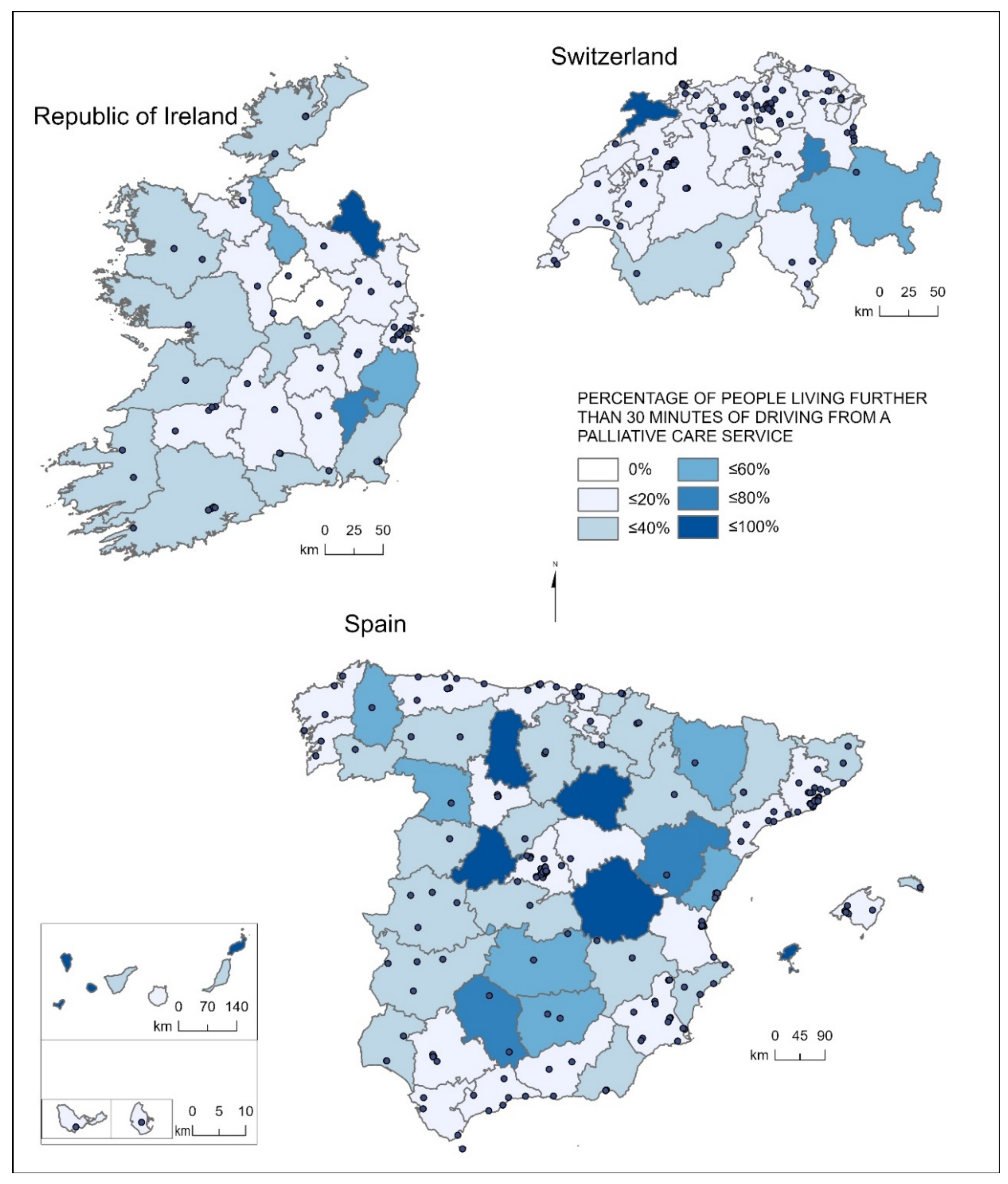
3. Results
3.1. Surface Coverage of Specialized Palliative Care Services
3.2. Potential Population’s Accessibility to Specialized Palliative Care Services
4. Discussion
5. Conclusions
Author Contributions
Funding
Institutional Review Board Statement
Informed Consent Statement
Conflicts of Interest
References
- World Health Organization Palliative Care. Available online: https://www.who.int/news-room/fact-sheets/detail/palliative-care (accessed on 12 July 2021).
- Arias-casais, N.; Garralda, E.; Rhee, J.Y.; Lima, L.; Pons, J.J.; Clark, D.; Hasselaar, J.; Ling, J.; Mosoui, D.; Centeno, C. EAPC Atlas of Palliative Care in Europe 2019; EAPC Vzw Press: Vilvoorde, Belgium, 2019. [Google Scholar]
- Sleeman, K.; de Brito, M.F.; Etkind, S.N.; Nkhoma, K.; Guo, P.; Higginson, I.J.; Gomes, B.; Harding, R. The escalating global burden of serious health-related suffering: Projections to 2060 by world regions, age groups, and health conditions. Lancet Glob. Health 2019, 7, e883–e892. [Google Scholar] [CrossRef] [Green Version]
- World Health Organization Universal Health Coverage. Available online: https://www.who.int/health-topics/universal-health-coverage#tab=tab_1 (accessed on 29 September 2021).
- World Health Organization. Sixty-Seventh World Health Assembly—Strengthening of Palliative Care as a Component of Comprehensive Care throughout the Life Course. 2014, p. 5. Available online: https://apps.who.int/gb/ebwha/pdf_files/WHA67/A67_R19-en.pdf (accessed on 12 July 2021).
- Knaul, F.M.; Farmer, P.; Krakauer, E.L.; De Lima, L.; Bhadelia, A.; Kwete, X.J.; Arreola-Ornelas, H.; Gómez-Dantés, O.; Rodriguez, N.M.; Alleyne, G.; et al. Alleviating the access abyss in palliative care and pain relief—An imperative of universal health coverage: The Lancet commission report. Lancet 2018, 391, 1391–1454. [Google Scholar] [CrossRef]
- Macharia, P.M.; Ray, N.; Giorgi, E.; Okiro, E.; Snow, R.W. Defining service catchment areas in low-resource settings. BMJ Glob. Health 2021, 6, e006381. [Google Scholar] [CrossRef] [PubMed]
- Ouma, P.; Macharia, P.M.; Okiro, E.; Alegana, V. Methods of measuring spatial accessibility to health care in Uganda. In Practicing Health Geography; Springer: Cham, Switzerland, 2021. [Google Scholar]
- Hart, T.; Nguyen, N.T.T.; Nowak, N.A.; Zhang, F.; Linhardt, R.J.; Diuk-Wasser, M.; Ram, S.; Kraiczy, P.; Lin, Y.P. Polymorphic factor H-binding activity of CspA protects Lyme borreliae from the host complement in feeding ticks to facilitate tick-to-host transmission. PLoS Pathog. 2018, 14, e1007106. [Google Scholar] [CrossRef] [PubMed] [Green Version]
- Ebener, S.; Stenberg, K.; Brun, M.; Monet, J.-P.; Ray, N.; Sobel, H.L.; Roos, N.; Gault, P.; Conlon, C.M.; Bailey, P.; et al. Proposing standardised geographical indicators of physical access to emergency obstetric and newborn care in low-income and middle-income countries. BMJ Glob. Health 2019, 4, e000778. [Google Scholar] [CrossRef] [PubMed] [Green Version]
- World Health Organization. Global Reference List of 100 Core Health Indicators (Plus Health-Related SDGs); WHO: Geneva, Switzerland, 2018. [Google Scholar]
- World Health Organization. Monitoring the Building Blocks of Health Systems: A Handbook of Indicators and Their Measurement Strategies; WHO: Geneva, Switzerland, 2010. [Google Scholar]
- Penchansky, R.; Thomas, J.W. The concept of access. Med. Care 1981, 19, 127–140. [Google Scholar] [CrossRef]
- Luo, W.; Wang, F. Measures of spatial accessibility to health care in a GIS environment: Synthesis and a case study in the Chicago region. Environ. Plan. B Plan. Des. 2003, 30, 865–884. [Google Scholar] [CrossRef] [PubMed] [Green Version]
- Luo, W.; Qi, Y. An enhanced two-step floating catchment area (E2SFCA) method for measuring spatial accessibility to primary care physicians. Health Place 2009, 15, 1100–1107. [Google Scholar] [CrossRef] [PubMed]
- Joseph, A.E.; Bantock, P.R. Measuring potential physical accessibility to general practitioners in rural areas: A method and case study. Soc. Sci. Med. 1982, 16, 85–90. [Google Scholar] [CrossRef]
- Khan, A.A. An integrated approach to measuring potential spatial access to health care services. Socio-Econ. Plan. Sci. 1992, 26, 275–287. [Google Scholar] [CrossRef]
- Geurs, K.T.; van Wee, B. Accessibility evaluation of land-use and transport strategies: Review and research directions. J. Transp. Geogr. 2003, 12, 127–140. [Google Scholar] [CrossRef]
- Giesbrecht, M.; Stajduhar, K.I.; Mollison, A.; Pauly, B.; Reimer-Kirkham, S.; McNeil, R.; Wallace, B.; Dosani, N.; Rose, C. Hospitals, clinics, and palliative care units: Place-based experiences of formal healthcare settings by people experiencing structural vulnerability at the end-of-life. Health Place 2018, 53, 43–51. [Google Scholar] [CrossRef]
- Crooks, V.A.; Schuurman, N.; Cinnamon, J.; Castleden, H.; Johnston, R. Refining a location analysis model using a mixed methods approach: Community readiness as a key factor in siting rural palliative care services. J. Mix. Methods Res. 2010, 5, 77–95. [Google Scholar] [CrossRef]
- Wong, S.; Regan, S. Patient perspectives on primary health care in rural communities: Effects of geography on access, continuity and efficiency. Rural. Remote Health 2009, 9, 1142. [Google Scholar] [CrossRef] [Green Version]
- Comber, A.J.; Brunsdon, C.; Radburn, R. A spatial analysis of variations in health access: Linking geography, socio-economic status and access perceptions. Int. J. Health Geogr. 2011, 10, 44. [Google Scholar] [CrossRef] [Green Version]
- Cinnamon, J.; Schuurman, N.; Crooks, V.A. Assessing the suitability of host communities for secondary palliative care hubs: A location analysis model. Health Place 2009, 15, 822–830. [Google Scholar] [CrossRef] [PubMed]
- Schuurman, N.; Amram, O.; Crooks, V.A.; Johnston, R.; Williams, A. A comparative analysis of potential spatio-temporal access to palliative care services in two Canadian provinces. BMC Health Serv. Res. 2015, 15, 270. [Google Scholar] [CrossRef] [PubMed] [Green Version]
- Lindley, L.C.; Edwards, S.L. Geographic access to hospice care for children with cancer in Tennessee, 2009 to 2011. Am. J. Hosp. Palliat. Med. 2014, 32, 849–854. [Google Scholar] [CrossRef] [PubMed] [Green Version]
- Wood, D.J.; Clark, D.; Gatrell, A.C. Equity of access to adult hospice inpatient care within north-west England. Palliat. Med. 2004, 18, 543–549. [Google Scholar] [CrossRef] [PubMed] [Green Version]
- Cinnamon, J.; Schuurman, N.; Crooks, V. A method to determine spatial access to specialized palliative care services using GIS. BMC Health Serv. Res. 2008, 8, 140. [Google Scholar] [CrossRef] [Green Version]
- Jaraíz-Cabanillas, F.; Gallego, J.A.G.; Molina, E.H.; Flores, S.L.; Jeong, J.S.; Vicuna, M.N.; Jadad, A.R. Network and spatial analysis to assess and guide decisions about equitable accessibility to health services: The public palliative care system in Extremadura (Spain). Divers. Equal. Health Care 2017, 14. [Google Scholar] [CrossRef]
- Virnig, B.A.; Ma, H.; Hartman, L.K.; Moscovice, I.; Carlin, B. Access to home-based hospice care for rural populations: Identification of areas lacking service. J. Palliat. Med. 2006, 9, 1292–1299. [Google Scholar] [CrossRef]
- Goldsmith, B.; Dietrich, J.; Du, Q.; Morrison, R.S. Variability in access to hospital palliative care in the United States. J. Palliat. Med. 2008, 11, 1094–1102. [Google Scholar] [CrossRef] [PubMed] [Green Version]
- Chukwusa, E.; Verne, J.; Polato, G.; Taylor, R.; Higginson, I.J.; Gao, W. Urban and rural differences in geographical accessibility to inpatient palliative and end-of-life (PEoLC) facilities and place of death: A national population-based study in England, UK. Int. J. Health Geogr. 2019, 18, 1–11. [Google Scholar] [CrossRef] [PubMed] [Green Version]
- Chukwusa, E.; Yu, P.; Verne, J.; Taylor, R.; Higginson, I.J.; Wei, G. Regional variations in geographic access to inpatient hospices and place of death: A Population-based study in England, UK. PLoS ONE 2020, 15, e0231666. [Google Scholar] [CrossRef] [PubMed]
- Gatrell, A.C.; Wood, D. Variation in geographic access to specialist inpatient hospices in England and Wales. Health Place 2012, 18, 832–840. [Google Scholar] [CrossRef]
- Currow, D.C.; Allingham, S.; Bird, S.; Yates, P.; Lewis, J.; Dawber, J.; Eagar, K. Referral patterns and proximity to palliative care inpatient services by level of socio-economic disadvantage. A national study using spatial analysis. BMC Health Serv. Res. 2012, 12, 424. [Google Scholar] [CrossRef] [PubMed] [Green Version]
- Pearson, C.; Verne, J.; Wells, C.; Polato, G.M.; Higginson, I.J.; Gao, W. Measuring geographical accessibility to palliative and end of life (PEoLC) related facilities: A comparative study in an area with well-developed Specialist Palliative Care (SPC) provision. BMC Palliat. Care 2017, 16, 14. [Google Scholar] [CrossRef] [PubMed] [Green Version]
- Healy, J.; Tang, S.; Patcharanarumol, W.; Annear, P. A framework for comparative analysis of health systems: Experiences from the Asia Pacific Observatory on health systems and policies. WHO South East Asia J. Public Health 2018, 7. [Google Scholar] [CrossRef] [PubMed] [Green Version]
- Schuurman, N.; Fiedler, R.S.; Grzybowski, S.C.W.; Grund, D. Defining rational hospital catchments for non-urban areas based on travel-time. Int. J. Health Geogr. 2006, 5, 43. [Google Scholar] [CrossRef] [PubMed] [Green Version]
- Carlson, M.D.; Bradley, E.H.; Du, Q.; Morrison, R.S. Geographic access to hospice in the United States. J. Palliat. Med. 2010, 13, 1331–1338. [Google Scholar] [CrossRef] [PubMed] [Green Version]
- Yu, J.A.; Ray, K.N.; Park, S.Y.; Barry, A.; Smith, C.B.; Ellis, P.G.; Schenker, Y. System-level factors associated with use of outpatient specialty palliative care among patients with advanced cancer. J. Oncol. Pract. 2019, 15, e10–e19. [Google Scholar] [CrossRef] [PubMed]
- UN. United Nations Population Division World Urbanization Prospects: The 2018 Re-Vision. Available online: https://population.un.org/wup (accessed on 9 May 2020).
- Palliative Care. Palliativkarte. Available online: https://www.palliativkarte.ch/ (accessed on 28 May 2021).
- Sociedad Española de Cuidados Paliativos Directorio de Cuidados Paliativos. Available online: https://www.secpal.com/directorio-1 (accessed on 28 May 2021).
- Irish Association for Palliative Care Directory. Available online: http://www.iapc.ie/directory (accessed on 28 May 2021).
- Fan, J.; Fu, C.; Stewart, K.; Zhang, L. Using big GPS trajectory data analytics for vehicle miles traveled estimation. Transp. Res. C Emerg. Technol. 2019, 103, 298–307. [Google Scholar] [CrossRef]
- ESRI Network Analysis Coverage. Available online: https://doc.arcgis.com/en/arcgis-online/reference/network-coverage.htm (accessed on 15 September 2021).
- Wan, N.; Zou, B.; Sternberg, T. A three-step floating catchment area method for analyzing spatial access to health services. Int. J. Geogr. Inf. Sci. 2012, 26, 1073–1089. [Google Scholar] [CrossRef]
- Luo, W. Using a GIS-based floating catchment method to assess areas with shortage of physicians. Health Place 2003, 10, 1–11. [Google Scholar] [CrossRef]
- Wang, F.; Luo, W. Assessing spatial and nonspatial factors for healthcare access: Towards an integrated approach to defining health professional shortage areas. Health Place 2005, 11, 131–146. [Google Scholar] [CrossRef] [PubMed]
- Ordnance Survey Ireland. Ordnance Survey Ireland Open Data Portal. Available online: https://data-osi.opendata.arcgis.com/ (accessed on 28 May 2021).
- Central Statistics Office Census 2016 Small Area Population Statistics. Available online: https://www.cso.ie/en/census/census2016reports/census2016smallareapopulationstatistics (accessed on 28 May 2021).
- Spanish National Geographic Institute Municipios IGN. Available online: https://opendata.esri.es/datasets/ComunidadSIG::municipios-ign/about (accessed on 28 May 2021).
- Instituto Nacional de Estadística Continous Municipal Register. Available online: https://www.ine.es/CDINEbase/consultar.do?mes=&operacion=Estad%EDstica+del+Padr%F3n+Continuo&id_oper=Ir (accessed on 28 May 2021).
- Bundesamt für Statistik Geodaten Der Bundesstatistik. Available online: https://www.bfs.admin.ch/bfs/de/home/dienstleistungen/geostat/geodaten-bundesstatistik.html (accessed on 28 May 2021).
- Federal Statistical Office Regional Portraits 2019: Key Data of All Communes. Available online: https://www.bfs.admin.ch/bfs/en/home/statistics/regional-statistics/regional-portraits-key-figures/communes.html (accessed on 29 September 2021).
- Barrozo, L.V.; Pérez-Machado, R.P.; Small, C.; Cabral-Miranda, W. Changing spatial perception: Dasymetric mapping to improve analysis of health outcomes in a megacity. J. Maps 2015, 12, 1242–1247. [Google Scholar] [CrossRef]
- Copernicus High Resolution Layer: Imperviousness Density (IMD) 2015. Available online: https://land.copernicus.eu/pan-european/high-resolution-layers/imperviousness/status-maps/2015 (accessed on 29 September 2021).
- Tao, R.; Downs, J.; Beckie, T.M.; Chen, Y.; McNelley, W. Examining spatial accessibility to COVID-19 testing sites in Florida. Ann. GIS 2020, 26, 319–327. [Google Scholar] [CrossRef]
- Ghorbanzadeh, M.; Kim, K.; Erman, E.; Horner, M.W. A comparative analysis of transportation-based accessibility to mental health services. Transp. Environ. 2020, 81, 102278. [Google Scholar] [CrossRef]
- Kang, J.-Y.; Michels, A.; Lyu, F.; Wang, S.; Agbodo, N.; Freeman, V.L.; Wang, S. Rapidly measuring spatial accessibility of COVID-19 healthcare resources: A case study of Illinois, USA. Int. J. Health Geogr. 2020, 19, 1–17. [Google Scholar] [CrossRef]
- Curtis, A.; Monet, J.-P.; Brun, M.; Bindaoudou, I.A.-K.; Daoudou, I.; Schaaf, M.; Agbigbi, Y.; Ray, N. National optimisation of accessibility to emergency obstetrical and neonatal care in Togo: A geospatial analysis. BMJ Open 2021, 11. [Google Scholar] [CrossRef] [PubMed]
- Langanke, T. Copernicus Land Monitoring Service—High Resolution Layer Imperviousness. Product Specifications Document 2016, 39. Available online: https://land.copernicus.eu/user-corner/technical-library/hrl-imperviousness-technical-document-prod-2015 (accessed on 29 September 2021).
- Gaughan, A.E.; Stevens, F.; Linard, C.; Jia, P.; Tatem, A.J. High resolution population distribution maps for Southeast Asia in 2010 and 2015. PLoS ONE 2013, 8, e55882. [Google Scholar] [CrossRef] [PubMed]
- Sorichetta, A.; Hornby, G.M.; Stevens, F.; Gaughan, A.E.; Linard, C.; Tatem, A.J. High-resolution gridded population datasets for Latin America and the Caribbean in 2010, 2015, and 2020. Sci. Data 2015, 2, 150045. [Google Scholar] [CrossRef] [PubMed] [Green Version]
- Lawal, O.; Anyiam, F.E. Modelling geographic accessibility to primary health care facilities: Combining open data and geospatial analysis. Geo-Spat. Inf. Sci. 2019, 22, 174–184. [Google Scholar] [CrossRef] [Green Version]
- Foody, G.M.; See, L.; Fritz, S.; van der Velde, M.; Perger, C.; Schill, C.; Boyd, D.; Comber, A. Accurate attribute mapping from volunteered geographic information: Issues of volunteer quantity and quality. Cartogr. J. 2015, 52, 336–344. [Google Scholar] [CrossRef]


| Service Areas Driving Time (Minutes) | Ireland | Spain | Switzerland | |||
|---|---|---|---|---|---|---|
| n | % | n | % | n | % | |
| 0–10 | 1,884,201 | 39.57 | 17,239,404 | 36.90 | 3,941,773 | 46.46 |
| 10–20 | 1,273,031 | 26.73 | 12,966,726 | 27.75 | 2,967,508 | 34.98 |
| 20–30 | 862,683 | 18.12 | 6,821,577 | 14.60 | 1,122,189 | 13.23 |
| Subtotal 0–30 | 4,019,915 | 84.42 | 37,027,707 | 79.25 | 8,031,471 | 94.66 |
| 30–40 | 446,579 | 9.38 | 4,691,593 | 10.04 | 244,503 | 2.88 |
| 40–50 | 175,881 | 3.69 | 2,402,829 | 5.14 | 93,006 | 1.10 |
| 50–60 | 56,899 | 1.19 | 1,112,064 | 2.38 | 46,955 | 0.55 |
| Subtotal 30–60 | 679,360 | 14.27 | 8,206,486 | 17.56 | 384,464 | 4.53 |
| 60–90 | 27,414 | 0.58 | 876,034 | 1.87 | 43,112 | 0.51 |
| over 90 | 35,177 | 0.74 | 612,753 | 1.31 | 25,083 | 0.30 |
| Subtotal ≥60 | 62,590 | 1.31 | 1,488,787 | 3.19 | 68,195 | 0.81 |
| Grand Total | 4,761,865 | 100.00% | 46,722,980 | 100.00% | 8,484,130 | 100.00% |
| Counties | 0–30 min | 30–60 min | Over 60 | Total | |||
|---|---|---|---|---|---|---|---|
| n | % | n | % | n | % | n | |
| Longford | 40,863 | 99.97 | 10 | 0.03 | 0 | 0.00 | 40,873 |
| Westmeath | 88,730 | 99.95 | 40 | 0.05 | 0 | 0.00 | 88,770 |
| Meath | 193,496 | 99.21 | 1248 | 0.64 | 300 | 0.15 | 195,044 |
| Dublin | 1,333,512 | 98.97 | 2862 | 0.21 | 10,985 | 0.82 | 1,347,359 |
| Kildare | 218,193 | 98.06 | 4311 | 1.94 | 0 | 0.00 | 222,504 |
| Kilkenny | 93,609 | 94.33 | 5623 | 5.67 | 0 | 0.00 | 99,232 |
| Laois | 79,071 | 93.36 | 5626 | 6.64 | 0 | 0.00 | 84,697 |
| Limerick | 180,987 | 92.86 | 13,912 | 7.14 | 0 | 0.00 | 194,899 |
| Cavan | 68,733 | 90.23 | 7443 | 9.77 | 0 | 0.00 | 76,176 |
| Tipperary | 143,291 | 89.81 | 16,262 | 10.19 | 0 | 0.00 | 159,553 |
| Louth | 115,582 | 89.68 | 12,104 | 9.39 | 1198 | 0.93 | 128,884 |
| Roscommon | 54,182 | 83.95 | 10,362 | 16.05 | 0 | 0.00 | 64,544 |
| Sligo | 54,058 | 82.49 | 10,290 | 15.70 | 1186 | 1.81 | 65,535 |
| Galway | 198,101 | 76.77 | 47,708 | 18.49 | 12,249 | 4.75 | 258,058 |
| Kerry | 112,275 | 76.01 | 26,448 | 17.91 | 8983 | 6.08 | 147,707 |
| Offaly | 59,015 | 75.70 | 18,946 | 24.30 | 0 | 0.00 | 77,961 |
| Clare | 89,232 | 75.10 | 28,547 | 24.03 | 1038 | 0.87 | 118,817 |
| Cork | 404,044 | 74.43 | 132,674 | 24.44 | 6150 | 1.13 | 542,868 |
| Wexford | 108,421 | 72.41 | 39,229 | 26.20 | 2072 | 1.38 | 149,722 |
| Waterford | 84,117 | 72.41 | 31,580 | 27.18 | 479 | 0.41 | 116,176 |
| Mayo | 86,514 | 66.29 | 34,504 | 26.44 | 9489 | 7.27 | 130,507 |
| Donegal | 98,452 | 61.84 | 54,249 | 34.08 | 6491 | 4.08 | 159,192 |
| Wicklow | 80,169 | 56.29 | 60,638 | 42.58 | 1617 | 1.14 | 142,425 |
| Leitrim | 16,896 | 52.73 | 15,146 | 47.27 | 3 | 0.01 | 32,044 |
| Carlow | 13,769 | 24.19 | 43,163 | 75.81 | 0 | 0.00 | 56,932 |
| Monaghan | 4601 | 7.50 | 56,434 | 91.93 | 351 | 0.57 | 61,386 |
| Ireland | 4,019,915 | 84.42 | 679,360 | 14.27 | 62,590 | 1.31 | 4,761,865 |
| Autonomous Regions | 0–30 min | 30–60 min | Over 60 | Total | |||
|---|---|---|---|---|---|---|---|
| n | % | n | % | n | % | n | |
| Ciudad Autónoma de Melilla | 85,010 | 98.41 | 0 | 0.00 | 1374 | 1.59 | 86,384 |
| Ciudad Autónoma de Ceuta | 83,399 | 97.95 | 0 | 0.00 | 1745 | 2.05 | 85,144 |
| Comunidad de Madrid | 6,438,968 | 97.89 | 138,417 | 2.10 | 693 | 0.01 | 6,578,079 |
| Cantabria | 546,052 | 94.11 | 27,173 | 4.68 | 7004 | 1.21 | 579,859 |
| Principado de Asturias | 959,820 | 93.35 | 59,033 | 5.74 | 9391 | 0.91 | 1,028,244 |
| Región de Murcia | 1,371,193 | 92.74 | 105,734 | 7.15 | 1582 | 0.11 | 1,478,509 |
| País Vasco | 1,925,815 | 87.57 | 270,928 | 12.32 | 2345 | 0.11 | 2,199,088 |
| Cataluña | 6,417,156 | 84.44 | 1,099,479 | 14.47 | 83,430 | 1.10 | 7,599,736 |
| Islas Baleares | 881,288 | 78.07 | 87,701 | 7.77 | 159,920 | 14.17 | 1,128,908 |
| Galicia | 2,103,396 | 77.85 | 529,309 | 19.59 | 69,037 | 2.56 | 2,701,743 |
| Extremadura | 797,488 | 74.33 | 236,666 | 22.06 | 38,709 | 3.61 | 1,072,863 |
| Comunidad Valencia | 3,684,580 | 74.23 | 1,192,828 | 24.03 | 86,295 | 1.74 | 4,963,703 |
| Andalucía | 6,138,419 | 73.21 | 2,032,086 | 24.24 | 213,903 | 2.55 | 8,384,408 |
| Aragón | 887,355 | 67.80 | 298,456 | 22.81 | 122,916 | 9.39 | 1,308,312 |
| Comunidad Foral de Navarra | 436,546 | 67.41 | 198,655 | 30.68 | 12,353 | 1.91 | 647,404 |
| La Rioja | 211,313 | 66.94 | 98,979 | 31.35 | 5382 | 1.70 | 315,675 |
| Canarias | 1,385,526 | 65.12 | 410,927 | 19.31 | 331,232 | 15.57 | 2,127,685 |
| Castilla y León | 1,474,924 | 61.22 | 740,966 | 30.76 | 193,274 | 8.02 | 2,409,164 |
| Castilla-La Mancha | 1,199,464 | 59.18 | 679,131 | 33.51 | 148,212 | 7.31 | 2,026,807 |
| Spain | 37,027,713 | 79.25 | 8,206,264 | 17.56 | 1,488,747 | 3.19 | 46,721,715 |
| Cantons | 0–30 min | 30–60 min | Over 60 | Total | |||
|---|---|---|---|---|---|---|---|
| n | % | n | % | n | % | n | |
| Zug | 125,421 | 100.00 | 0 | 0.00 | 0 | 0.00 | 125,421 |
| Basel-Stadt | 193,908 | 100.00 | 0 | 0.00 | 0 | 0.00 | 193,908 |
| Zürich | 1,504,214 | 99.99 | 131 | 0.01 | 2 | 0.00 | 1,504,347 |
| Aargau | 670,597 | 99.94 | 390 | 0.06 | 0 | 0.00 | 670,987 |
| Genève | 494,638 | 99.88 | 613 | 0.12 | 0 | 0.00 | 495,251 |
| Basel-Landschaft | 286,615 | 99.86 | 408 | 0.14 | 0 | 0.00 | 287,023 |
| Thurgau | 273,036 | 99.72 | 388 | 0.14 | 376 | 0.14 | 273,800 |
| Fribourg | 313,980 | 99.65 | 1086 | 0.34 | 9 | 0.00 | 315,075 |
| Appenzell Ausserhoden | 54,738 | 99.20 | 440 | 0.80 | 0 | 0.00 | 55,178 |
| Nidwalden | 42,409 | 98.69 | 348 | 0.81 | 213 | 0.50 | 42,970 |
| St. Gallen | 493,968 | 97.88 | 10,167 | 2.01 | 552 | 0.11 | 504,687 |
| Vaud | 773,376 | 97.51 | 19,584 | 2.47 | 168 | 0.02 | 793,128 |
| Luzern | 393,541 | 96.81 | 12,960 | 3.19 | 0 | 0.00 | 406,501 |
| Solothurn | 261,258 | 96.25 | 10,173 | 3.75 | 0 | 0.00 | 271,431 |
| Appenzell Innerrhoden | 15,479 | 96.11 | 626 | 3.89 | 0 | 0.00 | 16,105 |
| Neuchâtel | 169,447 | 95.21 | 8517 | 4.79 | 0 | 0.00 | 177,964 |
| Schwyz | 148,908 | 94.66 | 6238 | 3.97 | 2157 | 1.37 | 157,303 |
| Ticino | 334,214 | 94.49 | 15,007 | 4.24 | 4487 | 1.27 | 353,708 |
| Bern | 948,478 | 91.99 | 78,635 | 7.63 | 4008 | 0.39 | 1,031,121 |
| Schaffhausen | 70,232 | 86.33 | 11,121 | 13.67 | 0 | 0.00 | 81,353 |
| Obwalden | 31,750 | 84.50 | 5394 | 14.36 | 430 | 1.14 | 37,574 |
| Uri | 29,407 | 81.01 | 4931 | 13.58 | 1961 | 5.40 | 36,299 |
| Valais | 267,645 | 78.38 | 63,560 | 18.61 | 10,262 | 3.01 | 341,467 |
| Graubünden | 117,067 | 59.16 | 40,717 | 20.58 | 40,102 | 20.27 | 197,886 |
| Glarus | 9128 | 22.62 | 28,747 | 71.24 | 2475 | 6.13 | 40,350 |
| Jura | 8016 | 10.94 | 64,283 | 87.71 | 993 | 1.35 | 73,292 |
| Switzerland | 8,031,470 | 94.66 | 384,464 | 4.53 | 68,195 | 0.81 | 8,484,129 |
Publisher’s Note: MDPI stays neutral with regard to jurisdictional claims in published maps and institutional affiliations. |
© 2021 by the authors. Licensee MDPI, Basel, Switzerland. This article is an open access article distributed under the terms and conditions of the Creative Commons Attribution (CC BY) license (https://creativecommons.org/licenses/by/4.0/).
Share and Cite
van Steijn, D.; Pons Izquierdo, J.J.; Garralda Domezain, E.; Sánchez-Cárdenas, M.A.; Centeno Cortés, C. Population’s Potential Accessibility to Specialized Palliative Care Services: A Comparative Study in Three European Countries. Int. J. Environ. Res. Public Health 2021, 18, 10345. https://doi.org/10.3390/ijerph181910345
van Steijn D, Pons Izquierdo JJ, Garralda Domezain E, Sánchez-Cárdenas MA, Centeno Cortés C. Population’s Potential Accessibility to Specialized Palliative Care Services: A Comparative Study in Three European Countries. International Journal of Environmental Research and Public Health. 2021; 18(19):10345. https://doi.org/10.3390/ijerph181910345
Chicago/Turabian Stylevan Steijn, Danny, Juan José Pons Izquierdo, Eduardo Garralda Domezain, Miguel Antonio Sánchez-Cárdenas, and Carlos Centeno Cortés. 2021. "Population’s Potential Accessibility to Specialized Palliative Care Services: A Comparative Study in Three European Countries" International Journal of Environmental Research and Public Health 18, no. 19: 10345. https://doi.org/10.3390/ijerph181910345
APA Stylevan Steijn, D., Pons Izquierdo, J. J., Garralda Domezain, E., Sánchez-Cárdenas, M. A., & Centeno Cortés, C. (2021). Population’s Potential Accessibility to Specialized Palliative Care Services: A Comparative Study in Three European Countries. International Journal of Environmental Research and Public Health, 18(19), 10345. https://doi.org/10.3390/ijerph181910345