Dust Deposition Impacts at a Liquidated Gold Mine Village: Gauteng Province in South Africa


Abstract
1. Introduction
Background
2. Materials and Methods
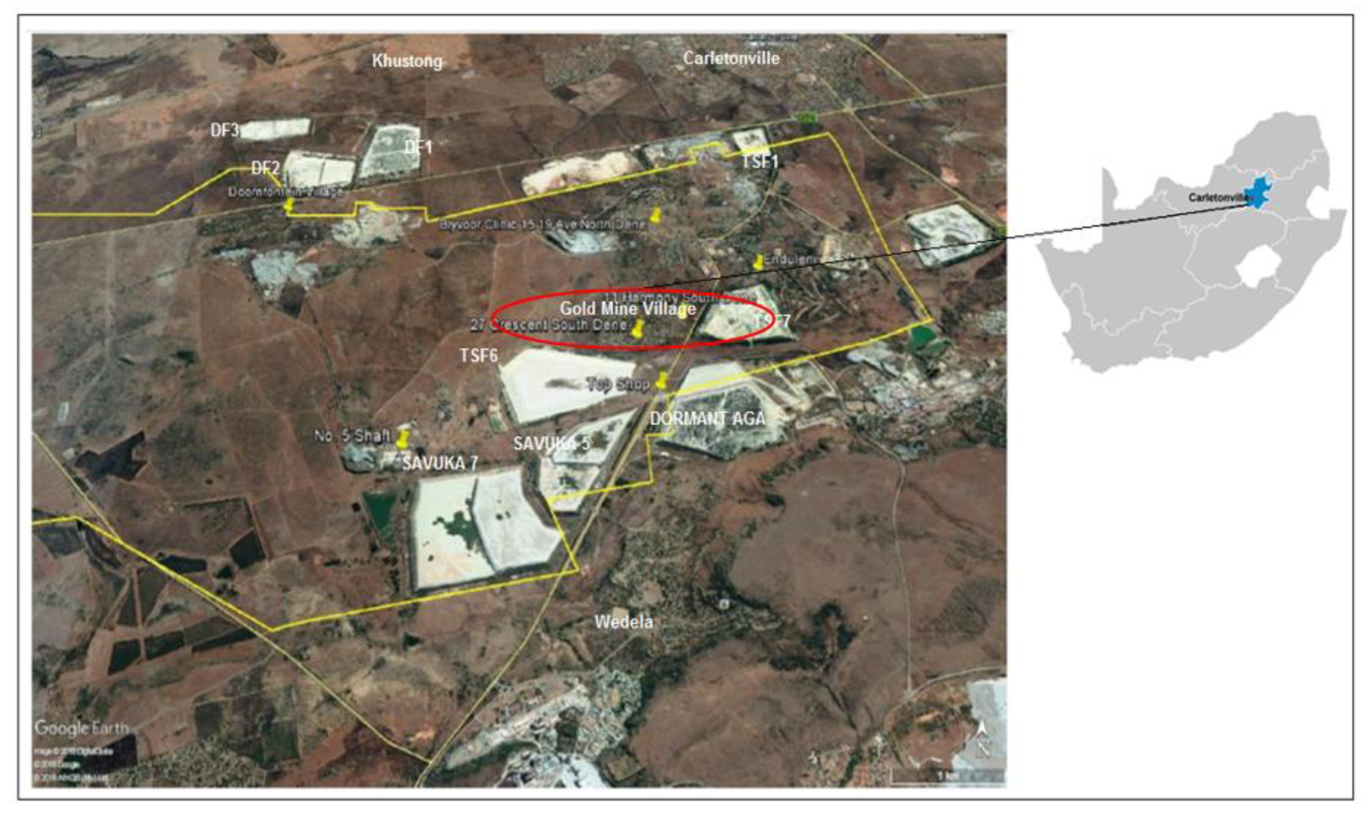
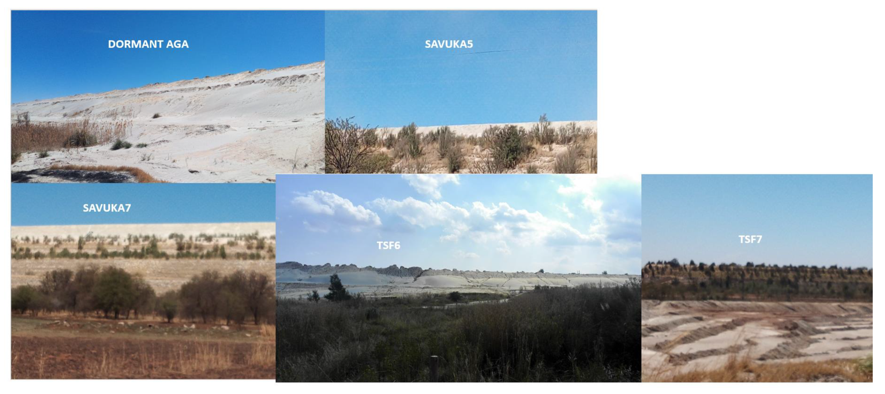
2.1. Study Area
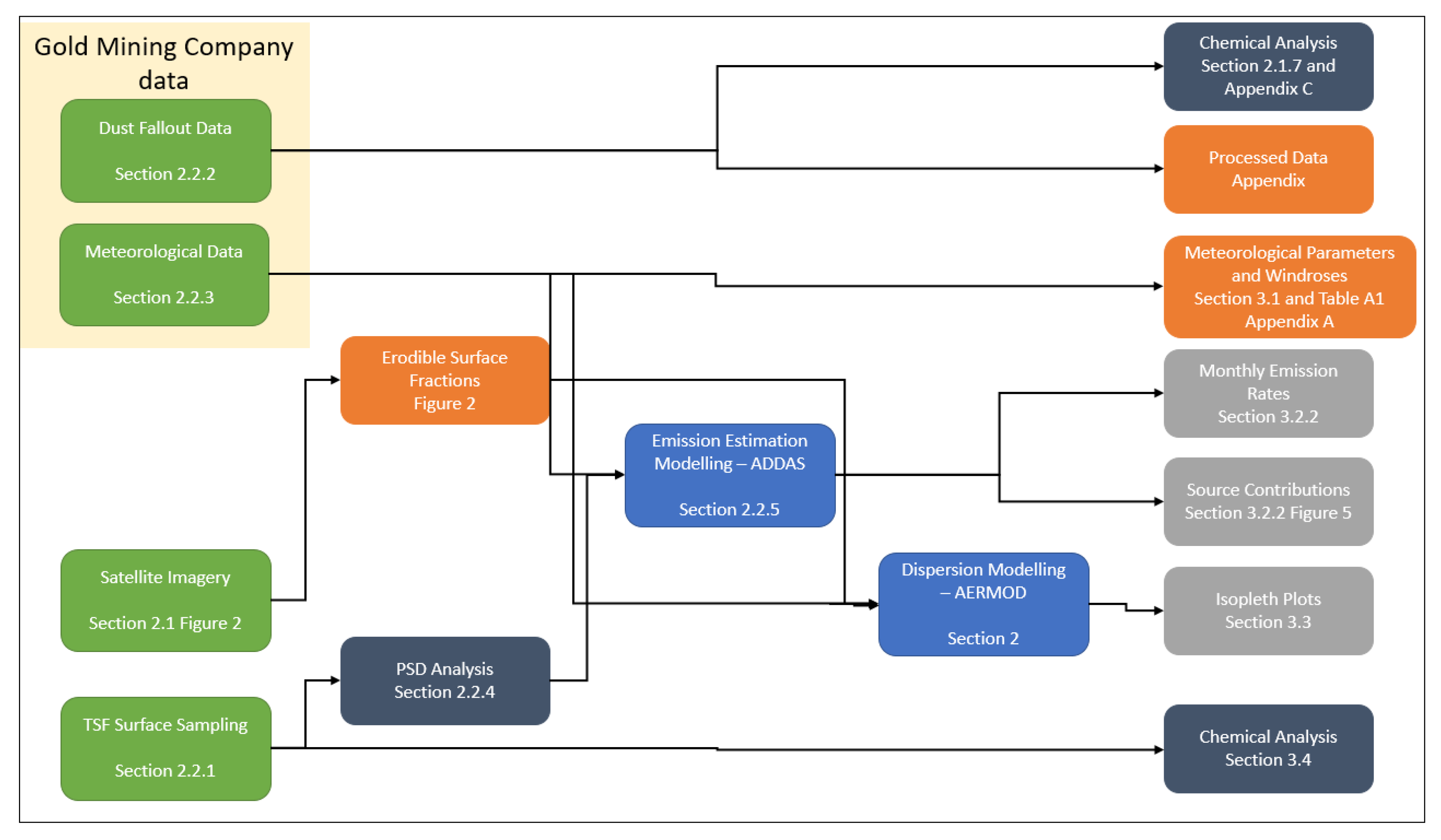
2.2. Methodology
2.2.1. Surface Sampling
2.2.2. Monitoring Data: Dust Fallout Sampling
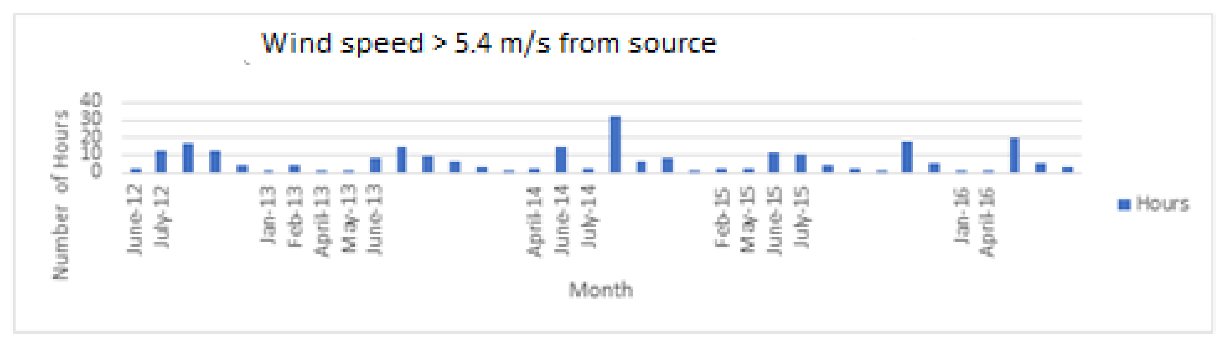
2.2.3. Meteorological Data
2.2.4. Particle Size Distribution
2.2.5. Emissions Quantification
2.2.6. Meteorological Data Analysis
2.2.7. Chemical Analysis
2.2.8. Model Validation and Limitations
3. Results
3.1. Meteorological Parameters
3.2. Dust Emission Rates
3.2.1. Particle Size Distribution
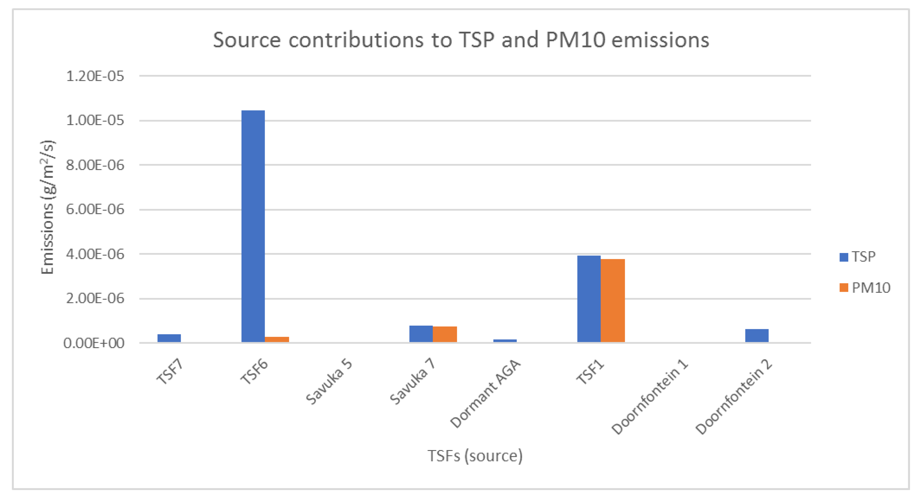
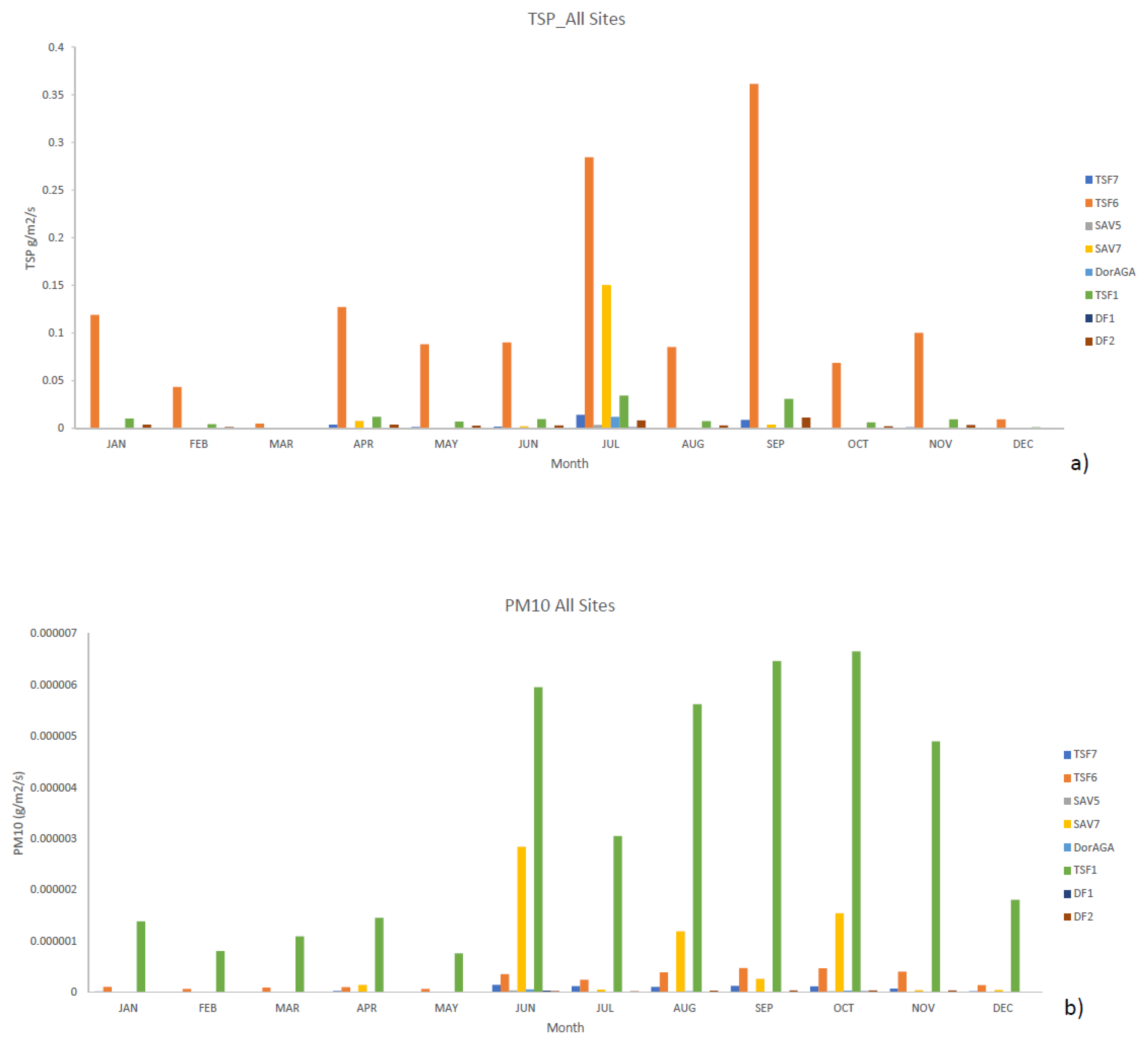
3.2.2. PM 10 and TSP Emission Rates
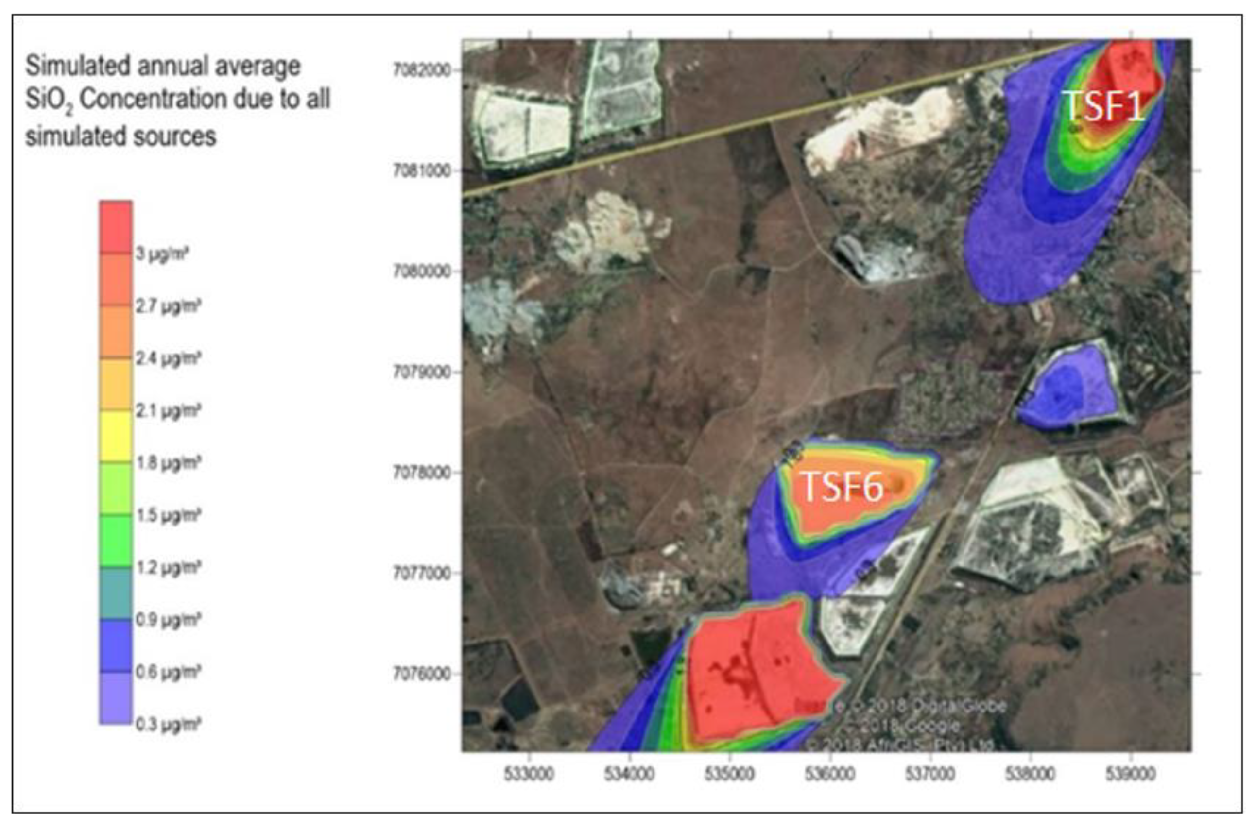
3.3. Dispersion Simulations
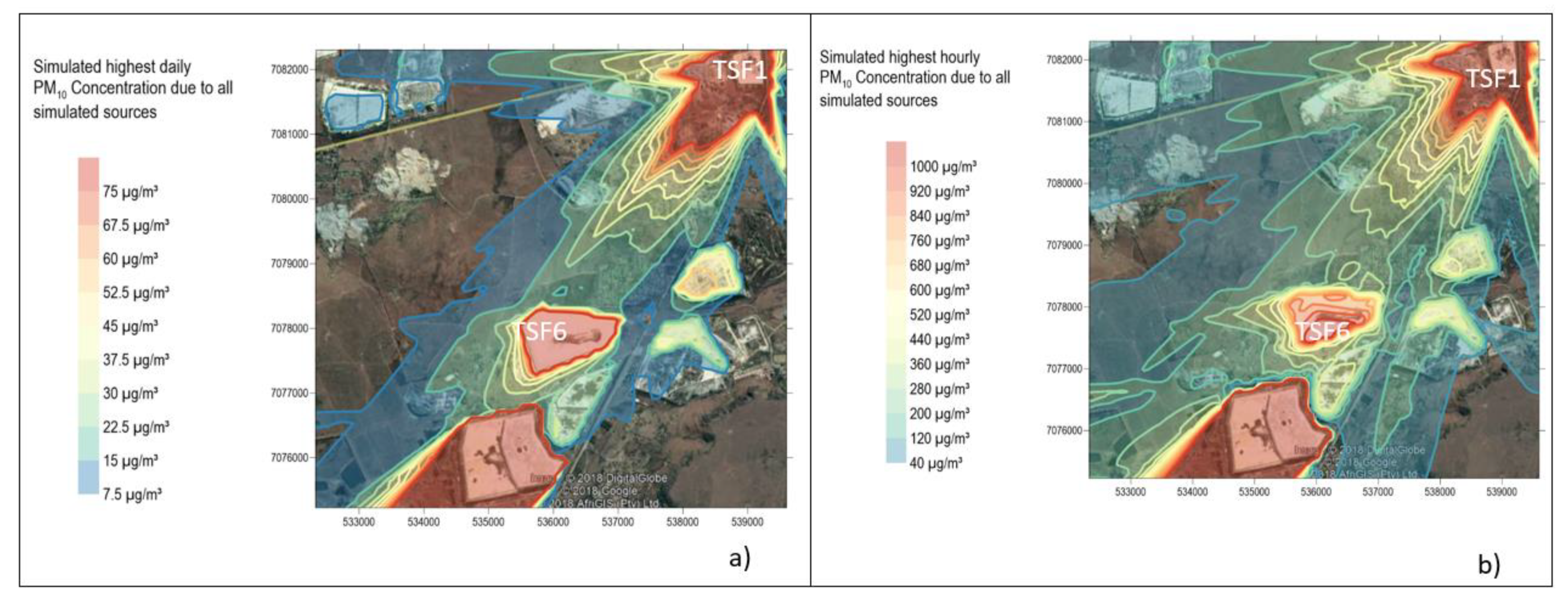
3.3.1. PM10 Simulations
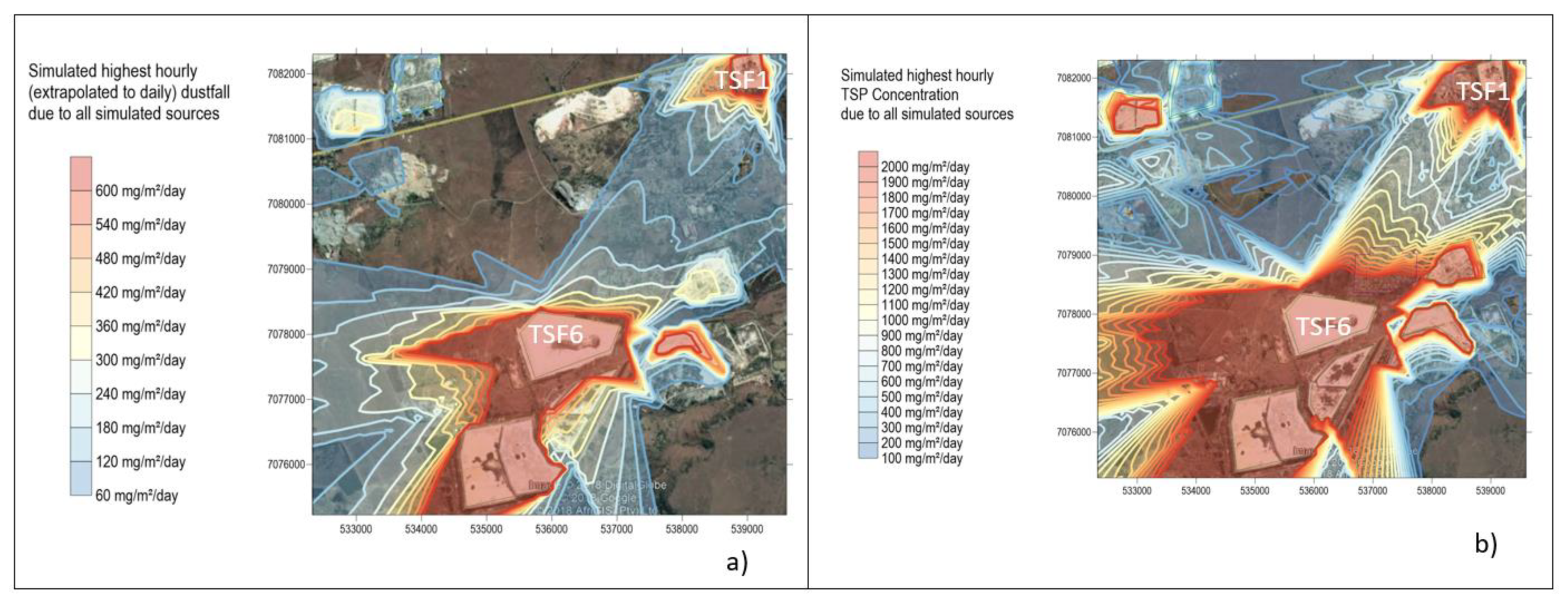
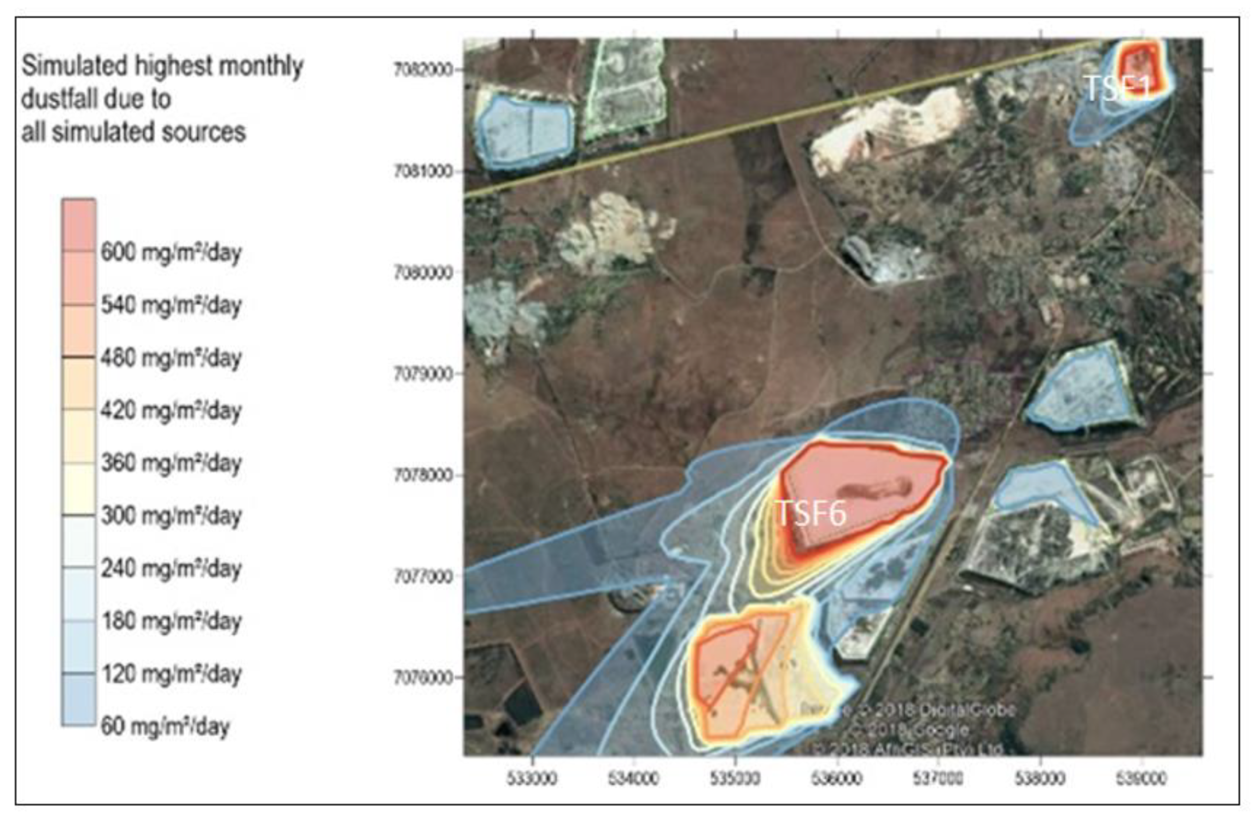
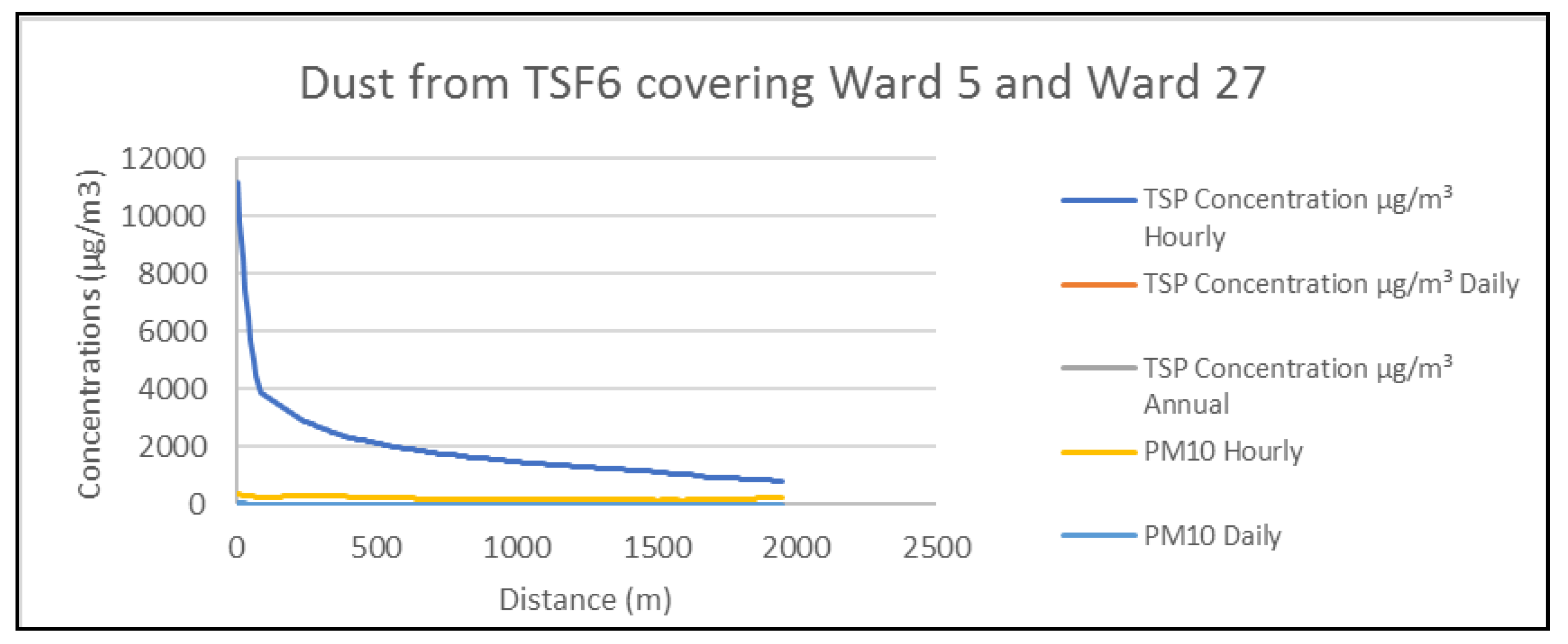
3.3.2. TSP and Dust Fall Simulations
3.3.3. Simulated Results and Measured Data
3.4. TSFs Chemistry
4. Discussion
5. Conclusions
Author Contributions
Funding
Acknowledgments
Conflicts of Interest
Appendix A


| Parameter Period from January 2012 to December 2017 | |
|---|---|
| Wind Direction | N; NE |
| Wind Speed | 2.94 m/s |
| Precipitation | 67 mm/month |
| Relative Humidity | 54–71% |
| Atmospheric Stability | Fairly neutral |
| Solar Radiation | 283 |
| Receptor Grid | 7.5 km × 7.5 km |
| Temperature | 10–23 °C |

| Location Name | Distance from TSF6 (m) | Highest Monthly Modelled Dust Fall Rate (mg/m2/day) | Highest Monthly Measured Dust Fall Rate (mg/m2/day) | Measured Dust Deposition Annual Average (mg/m2/day) |
|---|---|---|---|---|
| No. 5 Shaft | 1408 | 68 | 450 | 193 |
| 27 Crescent South Dene | 300 | 96 | 750 | 215 |
| Doornfontein Village House | 3984 | 10 | 480 | 200 |
| 1 Harmony South Dene | 866 | 23 | 490 | 168 |
| Top Shop | 400 | 45 | 600 | 277 |
| Joseph’s house | 2500 | 14 | 540 | 190 |
| Clinic | 2315 | 24 | 500 | 184 |
Appendix B

| Averaging Period | Concentration | Frequency of Exceedance | Compliance Date |
|---|---|---|---|
| 24 h | 120 µg/m3 | 4 | Immediate-31 December 2014 |
| 24 h | 75 µg/m3 | 4 | 1 January 2015 |
| 1 year | 50 µg/m3 | 0 | Immediate-31 December 2014 |
| 1 year | 40 µg/m3 | 0 | 1 January 2015 |

| Restriction Areas | Dustfall Rate (mg/m2/day, 30 Days Average) | Permitted Frequency of Exceeding Dust Fall Rate |
|---|---|---|
| Residential area | D < 600 | Two within a year, not sequential months. |
| Non-residential area | 600 < D < 1200 | Two within a year, not sequential months. |
Appendix C
| Composition | K 39 ppb | Cr 52 ppb | Mn 55 ppb | Fe 57 ppb | Ni 60 ppb | Zn 66 ppb | As ppb | U 238 ppb | Se ppb | Cd 11 ppb | Au 197 ppb | Pb 208 ppb |
|---|---|---|---|---|---|---|---|---|---|---|---|---|
| Location | ||||||||||||
| TSF7 | 375.22 | 49.43 | 687.56 | 14,737.49 | 194.58 | 182.23 | 32.15 | 50.50 | 1.47 | 0.53 | 0.49 | 7.55 |
| TSF6 | 241.43 | 51.18 | 126.28 | 14,865.82 | 28.85 | 21.16 | 30.06 | 3.77 | 0.31 | 0.03 | 0.10 | 4.40 |
| TSF1 | 298.66 | 45.95 | 77.45 | 11,906.95 | 23.70 | 37.57 | 18.24 | 12.25 | 0.24 | 0.03 | 0.26 | 4.60 |
| DORMANT AGA | 283.03 | 59.96 | 162.83 | 17,229.47 | 45.07 | 30.68 | 24.09 | 22.00 | 0.69 | 0.07 | 0.27 | 10.86 |
| SAVUKA 7 | 923.90 | 129.19 | 1110.43 | 29,434.75 | 75.34 | 71.53 | 30.01 | 67.28 | 0.55 | 0.13 | 0.35 | 27.35 |
| SAVUKA 5 | 3644.52 | 75.84 | 210.75 | 20,048.29 | 70.84 | 54.12 | 29.86 | 76.074 | 0.48 | 0.18 | 0.46 | 21.86 |
| DOORFONTEIN 1 | 359.15 | 70.28 | 164.24 | 15,235.13 | 51.66 | 43.42 | 18.37 | 4.05 | 0.37 | 0.07 | 0.06 | 5.54 |
| DOORNFONTEIN 2 | 197.51 | 14.62 | 14.54 | 3605.72 | 6.126 | 6.29 | 8.11 | 6.84 | 0.60 | 0.04 | 0.11 | 2.55 |
| Composition | SO3% | TiO2% | Al2O3% | CaO% | Fe2O3% | K2O% | MgO% | MnO% | Na2O% | P2O5% | SiO2% |
|---|---|---|---|---|---|---|---|---|---|---|---|
| Location | |||||||||||
| TSF7 | 0.27 | 0.30 | 5.70 | 0.41 | 2.86 | 0.65 | 0.76 | 0.06 | 0.15 | 0.06 | 85.32 |
| TSF6 | - | 0.26 | 4.61 | 0.24 | 2.23 | 0.59 | 0.58 | - | 0.08 | - | 90.37 |
| TSF1 | - | 0.32 | 5.22 | 0.21 | 2.25 | 0.64 | 0.55 | - | 0.09 | - | 89.00 |
| DORMANT AGA | - | 0.44 | 5.61 | 0.49 | 3.47 | 0.65 | 0.96 | - | 0.22 | 0.05 | 86.44 |
| SAVUKA 7 | 0.62 | 0.43 | 7.07 | 0.90 | 4.26 | 0.90 | 1.02 | 0.12 | 0.27 | 0.05 | 80.08 |
| SAVUKA 5 | 5.37 | 0.35 | 6.48 | 1.24 | 3.56 | 1.40 | 3.76 | - | 3.11 | 0.06 | 65.94 |
| DOORFONTEIN 1 | 0.14 | 0.38 | 7.88 | 0.55 | 3.78 | 1.05 | 1.47 | - | 0.16 | - | 81.60 |
| DOORNFONTEIN 2 | - | 0.24 | 3.60 | - | 1.20 | 0.38 | 0.12 | - | - | - | 93.29 |
References
- Pöschl, U. Atmospheric aerosols: Composition, transformation, climate and health effects. Angew. Chem. Int. Ed. 2005, 44, 7520–7540. [Google Scholar] [CrossRef] [PubMed]
- Martins, J.J. Acritical Evaluation of the Challenges Facing Dust Management within Gold Mining Regions of South Africa. Master’s Thesis, North West University, Potchefstroom, South Africa, 2014. [Google Scholar]
- Held, G.; Gore, B.J.; Surridge, A.D.; Tosen, G.R.; Turner, C.R.; Walmsley, R.D. Air Pollution and Its Impacts on the South African Highveld; Environmental Scientific Association: Cleveland, OH, USA, 1996; p. 144. [Google Scholar]
- World Health Organization (WHO). Ambient Air Pollution a Global Assessment of Exposure and Burden of Disease; World Health Organisation: Geneva, Switzerland, 2016; Available online: http://www.who.int/en/news-room/detail/12-05-2016-air-pollution-levels-rising-in-many-of-theworld-s-poorest-cities (accessed on 27 June 2018).
- Department of Water Affairs and Forestry (DWAF). Waste Generation in South Africa; Water Quality Management Series: Pretoria, South Africa, 2001.
- AngloGold Ashanti. Air Quality Assessment, West Wits Pits. 2004. Available online: https://www.academia.edu/5257660/The_Mine_Woodlands_Project_in_the_Witwatersrand_Basin_gold_fields_of_South_Africa_strategy_and_progress (accessed on 3 April 2019).
- Moreno, T.; Querol, X.; Alastuey, A.; Ballester, F.; Gibbons, W. Airborne particulate matter and premature deaths in urban Europe: The new WHO guidelines and the challenge ahead as illustrated by Spain. Eur. J. Epidemiol. 2006, 22, 1–5. [Google Scholar] [CrossRef] [PubMed]
- Maseki, J. Health risk posed by enriched heavy metals (As, Cd, and Cr) in airborne particles from Witwatersrand gold tailings. J. S. Afr. Inst. Min. Met. 2017, 117, 663–669. [Google Scholar] [CrossRef]
- Gauteng Department of Agriculture and Rural Development. Conceptual Study on Reclamation of Mine Residue Areas for Development Purposes; Rep No. 4250074879: 118; North West University: Potchefstroom, North West Province, South Africa, 2009.
- Annegarn, H.J.; Sithole, J. Dust monitoring and mitigation on gold tailings reclamation. In Proceedings of the Mine Ventilation Society Symposium: Occupational Health “Impact Prevention and Aftermath Strategies”, Pretoria, South Africa, 28 February–1 March 2002; CSIR: Pretoria, South Africa, 2002; p. 13. [Google Scholar]
- Annegarn, H.J.; Zucchiatti, A.; Selloschop, J.P.F.; Booth-Jones, P. PIXE characterisation of airborne dust in the mining environment. Nucl. Instrum. Methods Phys. Res. Sect. B Beam Interact. Mater. At. 1987, 22, 325–330. [Google Scholar] [CrossRef]
- Blight, G.E.; Caldwell, J.A. The abatement of pollution from abandoned gold residue dams. J. S. Afr. Inst. Min. Metall. 1984, 84, 1–9. [Google Scholar]
- Ojelede, M.E.; Annegarn, H.J.; Kneen, M.A. Evaluation of aeolian emissions from gold mine tailings on the Witwatersrand. Aeol. Res. 2012, 3, 477–486. [Google Scholar] [CrossRef]
- Oguntoke, O.; Ojelede, E.M.; Annegarn, J.H. Frequency of mine dust episodes and the influence of meteorological parameters in the Witwatersrand area, South Africa. Int. J. Atmos. Sci. 2013, 2013, 128463. [Google Scholar] [CrossRef]
- Oelofse, S.H.H.; Cobbing, J.; Hobbs, P. The Pollution and Destruction Threat of Gold Mining Waste on the Witwatersrand—A West Rand Case Study. 2014. Available online: http://www.anthonyturton.com/assets/my_documents/my_files/983_SWEMP.pdf (accessed on 3 April 2019).
- Warhurst, A.; Noronha, L. Mining, Mineral Processing and Extractive Metallurgy: An Overview of the Technologies and Their Impact on the Physical Environment, in Environmental Policy in Mining: Corporate Strategy and Planning for Closure; CRC Press: Boca Raton, FL, USA, 2000. [Google Scholar]
- Claassen, C.D. Casarett and Doull’s Toxicology. In The Basic Science of Poisons, 6th ed.; McGraw-Hill: New York, NY, USA, 2006. [Google Scholar]
- International Council on Mining and Metals (ICMM). Planning for Integrated Mine Closure: Toolkit. Newmont: International Council on Mining and Metals. 2019. Available online: http://www.icmm.com/website/publications/pdfs/closure/190107_good_practice_guide_web.pdf (accessed on 10 June 2019).
- Mpanza, M.; Moolla, R. The assessment of the external costs of dust fallout in Blyvooruitzicht Gold Mining Village. In Proceedings of the VII National Association for Clean Air (NACA) Conference, Protea Hotel by Marriot|Stellenbosch|Technopark|Western Cape, Cape Town, South Africa, 3–4 October 2019; National Association of Clean Air: Centurion, South Africa; Pretoria, South Africa, 2019. [Google Scholar]
- Chevrel, S.; Courant, C.; Cottard, F.; Coetzee, H. Very high resolution remote sensing and GIS modelling in multiscale approach of a mining related environmental risk analysis in urbanised areas: Example of the Witwatersrand goldfield, East Rand, South Africa. In Proceedings of the 4th European Congress on Regional Geoscientific Cartography and Information for Spatial Planning and Information for Spatial Planning, Regione Emilia-Romagna, Bologna, Italy, 17–20 June 2003; pp. 17–20. [Google Scholar]
- United States Environmental Protection Agency (USEPA). Emission Factor Document, Section 11.9 Western Surface Coal Mining; Research Triangle Park Office of Air Quality Planning and Standards, United States Environmental Protection Agency: Waterbury, CT, USA, 1998.
- Pasquill, F.; Smith, F.B. Atmospheric Diffusion: Study of the Dispersion of Windborne Material from Industrial and Other Sources; Ellis Horwood Ltd.: Chichester, UK, 1983. [Google Scholar]
- Marticorena, B.; Bergametti, G. Modeling the atmospheric dust cycle: 1. Design of a soil-derived dust emission scheme. J. Geophys. Res. Space Phys. 1995, 100, 16415–16430. [Google Scholar] [CrossRef]
- Burger, L.W. Complexities in the Estimation of Emissions and Impacts of Wind Generated Fugitive Dust. Airshed. 2010. Available online: https://www.airshed.co.za/Downloads/Publications/9%20Lucian%20Burger%20NACA2010.pdf (accessed on 5 March 2019).
- National Pollutant Inventory (NPI). Emissions Estimation Technique Manual for Mining; Version 3.1; Australian Government Department of Sustainability, Environment, Water, Population and Communities: Canberra, Australia, 2012.
- United States Environmental Protection Agency (USEPA). Human Health Risk Assessment Protocol. Appendix C. Risk Characterization Equations; United States Environmental Protection Agency: Washington, DC, USA, 2006. Available online: https://archive.epa.gov/epawaste/hazard/tsd/td/web/pdf/05hhrapapc.pdf (accessed on 10 August 2019).
- Liebenberg-Enslin, H. A Functional Dependence Analysis of Wind Erosion Modelling System Parameters to Determine a Practical Approach for Wind Erosion Assessments. Ph.D. Thesis, University of Johannesburg, Johannesburg, South Africa, May 2014. [Google Scholar]
- Shaw, D.M.; Dostal, J.; Keays, R.R. Additional estimates of continental surface Precambrien shield composition in Canada. Geochim. Cosmochim. Acta 1971, 40, 73–84. [Google Scholar] [CrossRef]
- Oke, T.T. Boundary Layer Climates; Routledge: London, UK, 1990. [Google Scholar]
- Tegen, I.; Fung, I. Contribution to the atmospheric mineral aerosol load from land surface modification. J. Geoph. Res. Atmos. 1995, 100, 18707–18726. [Google Scholar] [CrossRef]
- Liebenberg-Enslin, H. Air Quality Baseline Assessment for West Wits. 2014. Available online: https://www.airshed.co.za//Downloads/Publications/#Dispersion%20Modelling (accessed on 5 March 2019).
- Espinosa, A.J.F.; Rodriguez, F.J.; Barragan, D.I.R.; Sanchez, J.C.J. Size distribution of metals in urban aerosols in Seville (Spain). Atmos. Environ. 2001, 35, 2595–2601. [Google Scholar] [CrossRef]
- Paschoa, A.S.; Wrenn, M.E.; Jones, K.; Cholewa, M.; Carvalho, S.M. Elemental Composition of Airborne Particulates in Uranium Mining and Milling Operations, 8th Conference on the Application of Accelerators in Research and Industry; Brookhaven National Lab.: Upton, NY, USA, 1984. [Google Scholar]
- Pope, C.A.; Dockery, D. Acute health effects of PM10 pollution on symptomatic and asymptomatic children. Am. Rev. Respir. Dis. 1992, 145, 1123–1128. [Google Scholar] [CrossRef] [PubMed]
- Pope, C.A.; Kanner, R.E. Acute Effects of PM10Pollution on Pulmonary Function of Smokers with Mild to Moderate Chronic Obstructive Pulmonary Disease. Am. Rev. Respir. Dis. 1993, 147, 1336–1340. [Google Scholar] [CrossRef] [PubMed]
- Quah, E.; Boon, T.L. The economic cost of particulate air pollution on health in Singapore. J. Asian Econ. 2003, 14, 73–90. [Google Scholar] [CrossRef]
- Cohen, D.; Garton, D.; Stelcer, E. Multi-element methods for fine particulate source appointment at the global baseline station at Cape Grim, Tasmania. Nucl. Inst. Meth. Phys. Res. 2000, 161, 775–779. [Google Scholar] [CrossRef]
- Chay, K.Y.; Greenstone, M. Does Air Quality Matter? Evidence from the Housing Market. J. Political Econ. 2005, 113, 376–424. [Google Scholar] [CrossRef]
- Makgae, M. Key Areas in Waste Management: A South African Perspective; INTECH Open Access Publisher: London, UK, 2011. [Google Scholar]
- Maseki, J.H. Risk Assessment of Inhaled and Ingested Airborne Particles in the Vicinity of Gold Mine Tailings: Case Study of the Witwatersrand Basin. Master’s Thesis, University of Johannesburg, Johannesburg, South Africa, 2013. [Google Scholar]
- Dudu, V.P.; Mathuthu, M.; Manjoro, M. Assessment of heavy metals and radionuclides in dust fallout in the West Rand mining area of South Africa. Clean Air J. 2018, 28, 42–52. [Google Scholar] [CrossRef]
- Ersoy, A.T.; Yunsel, T.Y.; Cetin, M. Characterisation of land contaminated by past heavy metal mining using Geostatistical method. Archives of Environ. Arch. Environ. Contam. Toxicol. 2004, 46, 162–175. [Google Scholar] [CrossRef]
- Mendez, M.O.; Maier, R.M. Phyto-remediation of mine tailings in temperate and arid environments. Review of Environ. Sci. Biotech. 2008, 7, 47–59. [Google Scholar] [CrossRef]
- Larkin, J.; Coetzee, H.; Guy, S.; Watterson, J. Environmental radioactivity in South Africa. Radiat. Phys. Chem. 2004, 71, 795–796. [Google Scholar] [CrossRef]
- Dockery, D.; Pope, C.A. Acute respiratory effects of particulate air pollution. Annu. Rev. Public Health 1994, 155, 107–132. [Google Scholar] [CrossRef] [PubMed]
- American Thoracic Society (ATS). Adverse effects of crystalline silica exposure: American Thoracic Society Committee of the Scientific Assembly on Environmental Occupational Health. Am. J. Res. Critic. Care Med. 1997, 155, 761–765. [Google Scholar] [CrossRef]
- Shanklin, D.R.; Smalley, D.L. The immunopathology of siliconosis. History, clinical presentation, and relation to silicosis and the chemistry of silicon and silicone. Immunol. Res. 1998, 18, 125–173. [Google Scholar] [CrossRef] [PubMed]
- Hassanien, M.A.; Abdellatif, M.N.; Saleh, E.A.; Mohamed, M.F. Inhalation intake assessment of air pollutants exposure over Cairo, Egypt. In Exposure and Risk Assessment of Chemical Pollution—Contemporary Methodology; Simeonov, L.I., Hassanien, M.A., Eds.; Springer: Sofia, Bulgaria, 2009; pp. 303–315. [Google Scholar]
- Rapant, S.; Dietzová, Z.; Cicmanová, S. Environmental and health risk assessment in abandoned mining area, Zlata Idka, Slovakia. Environ. Earth Sci. 2006, 51, 387–397. [Google Scholar] [CrossRef]
- Turšič, J.; Radić, H.; Kovačevič, M.; Veber, M. Determination of Selected Trace Elements in Airborne Aerosol Particles Using Different Sample Preparation. Arch. Ind. Hyg. Toxicol. 2008, 59, 111–116. [Google Scholar] [CrossRef][Green Version]
- Wedepohl, K.H. The composition of the continental crust. Geochim. Cosmochim. Acta 1995, 59, 1217–1232. [Google Scholar] [CrossRef]
- Taylor, S.R.; McLennan, S.M. The geochemical evolution of the continental crust. Rev. Geophys. 1995, 33, 241–265. [Google Scholar] [CrossRef]
- Walker, N. Research Concept: Nanoscale Gold. 2007. Available online: http//ntp.niehs.nih.gov/ntp/…/6_walker_Nanogold_for_BSC_120607.pdf (accessed on 20 October 2019).
- Öhlander, B.; Müller, B.; Axelsson, M.; Alakangas, L. An attempt to use LA-ICP-SMS to quantify enrichment of trace elements on pyrite surfaces in oxidizing mine tailings. J. Geochem. Explor. 2007, 92, 1–12. [Google Scholar] [CrossRef]
- Foya, S.; Reimold, W.; Przybylowicz, W.; Gibson, R. PIXE microanalysis of gold-pyrite associations from the Kimberley Reefs, Witwatersrand basin, South Africa. Nucl. Instrum. Methods Phys. Res. Sect. B Beam Interact. Mater. Atoms 1999, 158, 588–592. [Google Scholar] [CrossRef]
- Simon, G.; Kao, L.-S.; Huang, H.; Penner-Hahn, J.E.; Kesler, S.E. Oxidation state of gold and arsenic in gold-bearing arsenian pyrite. Am. Miner. 1999, 84, 1071–1079. [Google Scholar] [CrossRef]


| Location | Density (kg/m3) | Moisture (%) | Surface Cover (%) | Undisturbed-Non-Vegetation (Y/N) | Min U*t | Erodible Fraction (%) |
|---|---|---|---|---|---|---|
| TSF7 | 2640 | 0.69 | 48 | N | 5.4 | 52 |
| TSF6 | 2640 | 0.09 | 10 | Y | 5.4 | 90 |
| SAVUKA 5 | 2640 | 4.14 | 19 | N | 5.4 | 81 |
| SAVUKA 7 | 2640 | 0.48 | 27 | N | 5.4 | 73 |
| DORMANT AGA | 2000 | 0.07 | 87 | N | 5.4 | 13 |
| TSF1 | 2000 | 0.04 | 20 | Y | 5.4 | 80 |
| DOORFONTEIN 1 | 2000 | 0.07 | 90 | N | 5.4 | 10 |
| DOORFONTEIN 2 | 2000 | 0.08 | 1 | N | 5.4 | 99 |
© 2020 by the authors. Licensee MDPI, Basel, Switzerland. This article is an open access article distributed under the terms and conditions of the Creative Commons Attribution (CC BY) license (http://creativecommons.org/licenses/by/4.0/).
Share and Cite
Mpanza, M.; Adam, E.; Moolla, R. Dust Deposition Impacts at a Liquidated Gold Mine Village: Gauteng Province in South Africa. Int. J. Environ. Res. Public Health 2020, 17, 4929. https://doi.org/10.3390/ijerph17144929
Mpanza M, Adam E, Moolla R. Dust Deposition Impacts at a Liquidated Gold Mine Village: Gauteng Province in South Africa. International Journal of Environmental Research and Public Health. 2020; 17(14):4929. https://doi.org/10.3390/ijerph17144929
Chicago/Turabian StyleMpanza, Mbalenhle, Elhadi Adam, and Raeesa Moolla. 2020. "Dust Deposition Impacts at a Liquidated Gold Mine Village: Gauteng Province in South Africa" International Journal of Environmental Research and Public Health 17, no. 14: 4929. https://doi.org/10.3390/ijerph17144929
APA StyleMpanza, M., Adam, E., & Moolla, R. (2020). Dust Deposition Impacts at a Liquidated Gold Mine Village: Gauteng Province in South Africa. International Journal of Environmental Research and Public Health, 17(14), 4929. https://doi.org/10.3390/ijerph17144929