PM2.5 Pollutant in Asia—A Comparison of Metropolis Cities in Indonesia and Taiwan


 and
and 
Abstract
1. Introduction
2. Materials and Methods
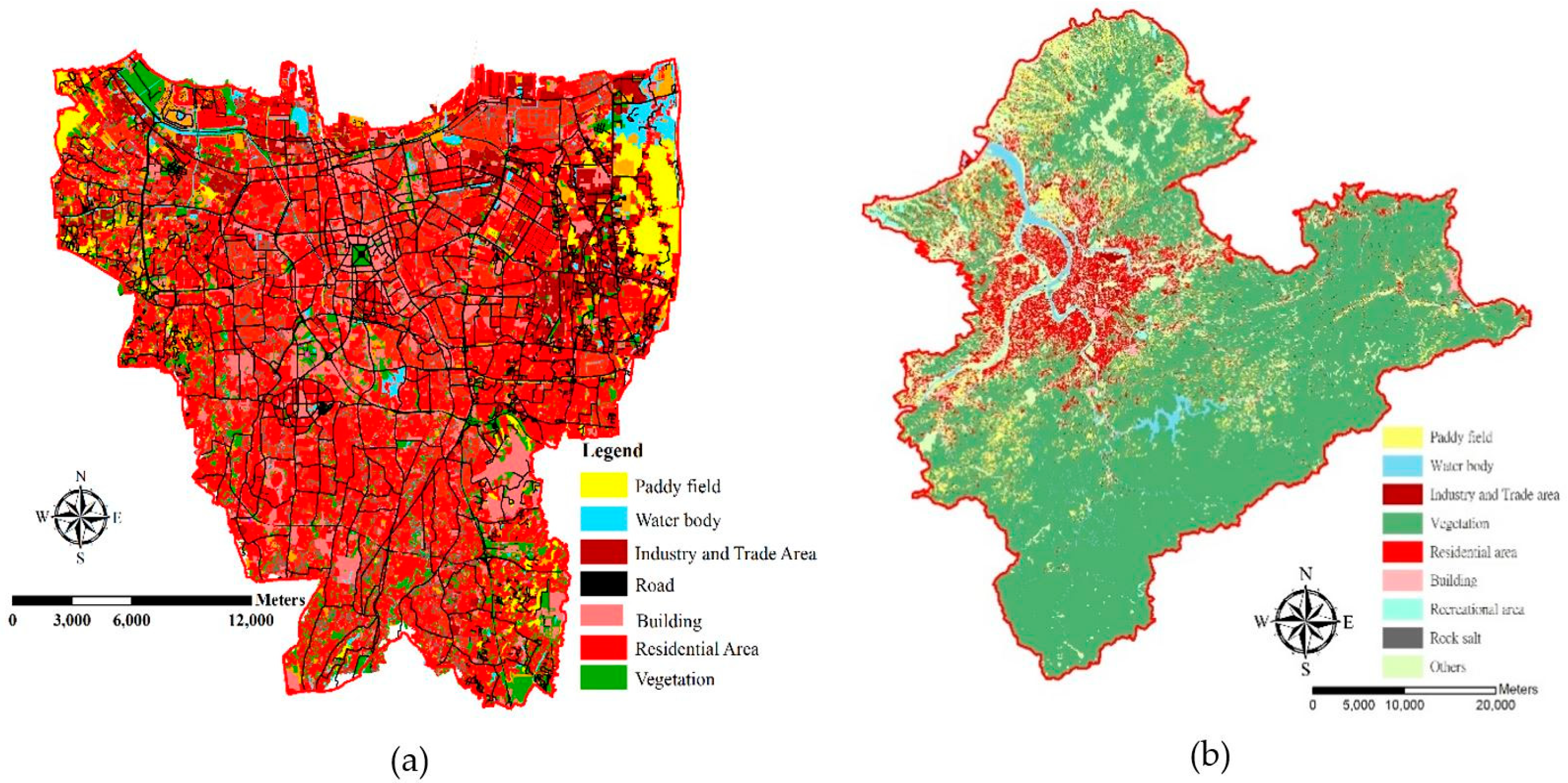
2.1. Study Area
2.2. PM2.5 Concentration Data
2.3. Geographic Information Datasets
2.4. LUR Modelling and Validation
3. Results
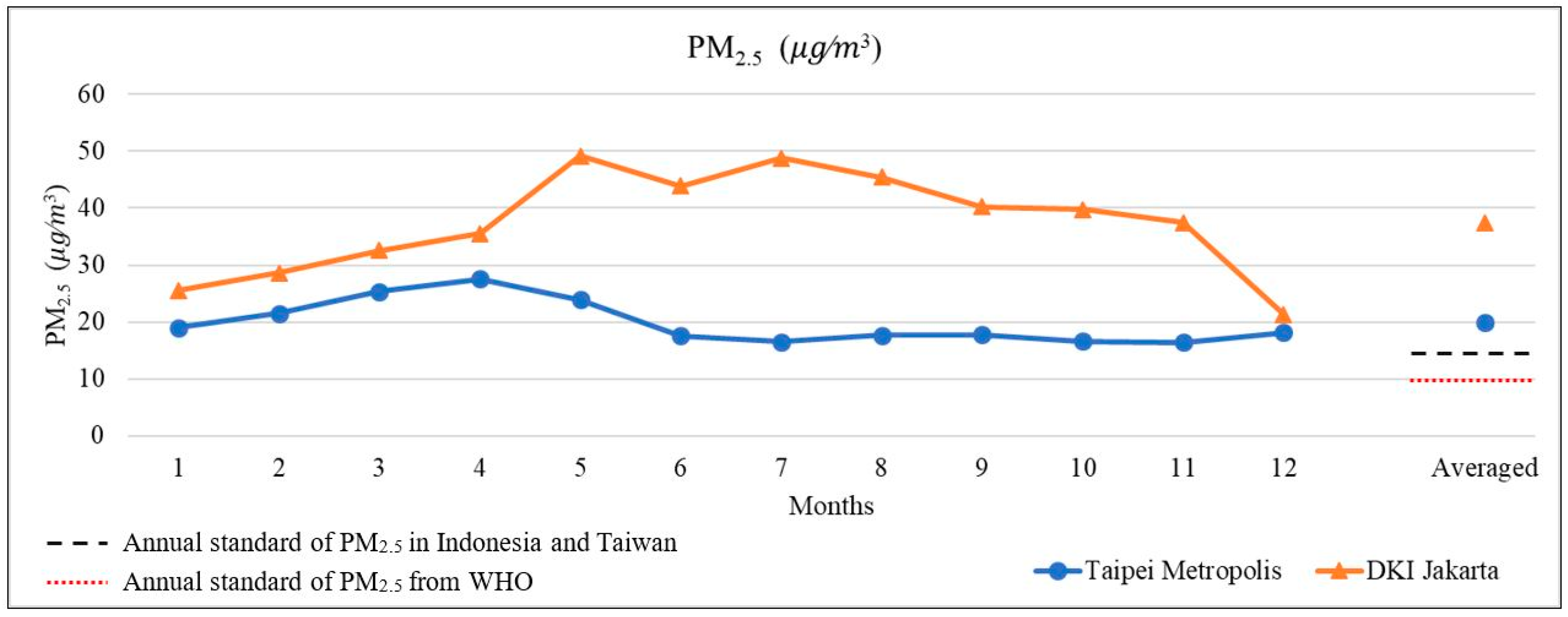
3.1. PM2.5 Concentrations between Indonesia and Taiwan
3.2. LUR Development
3.2.1. PM2.5 Model in Indonesia
3.2.2. PM2.5 model in Taiwan
3.3. Model Performance
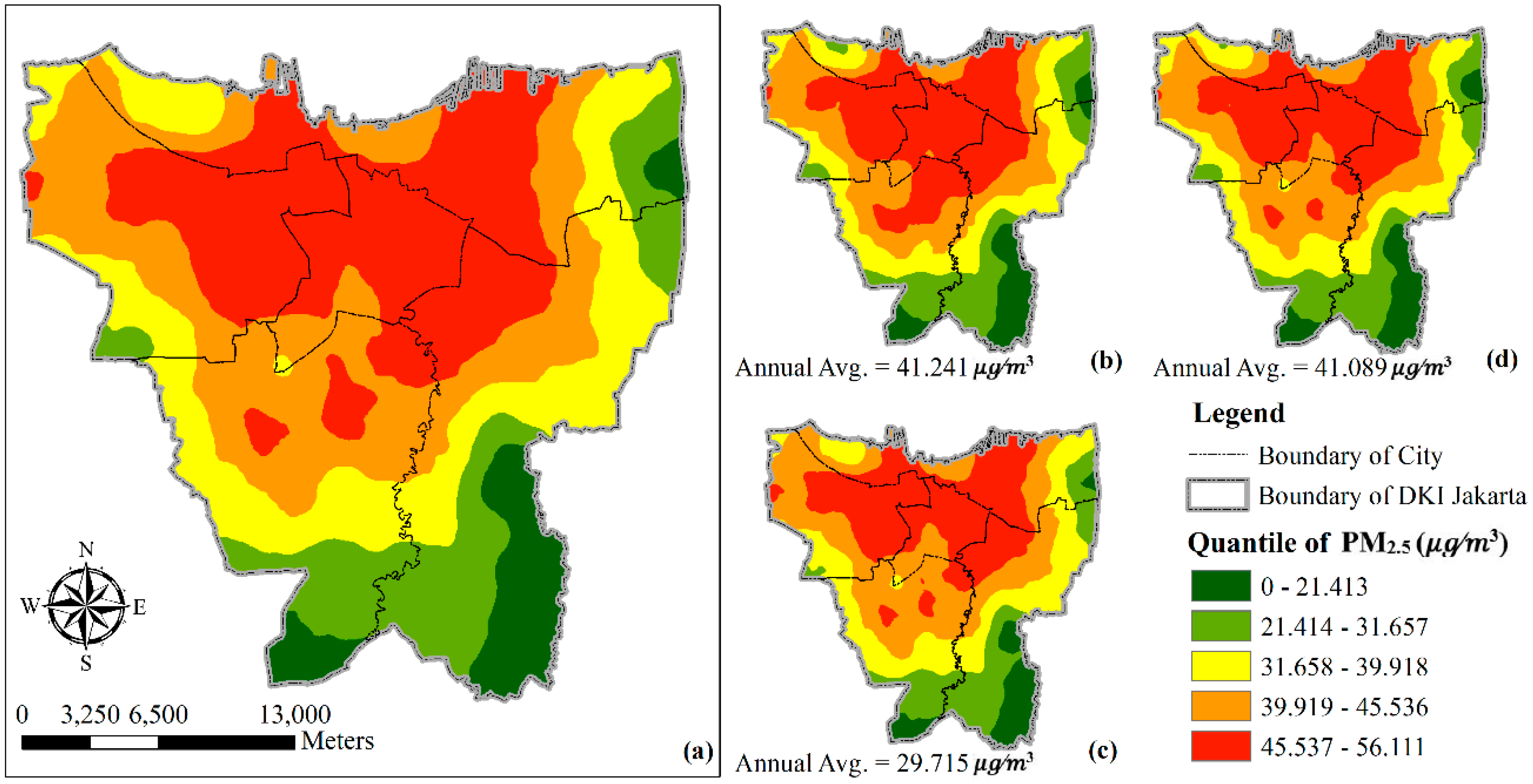
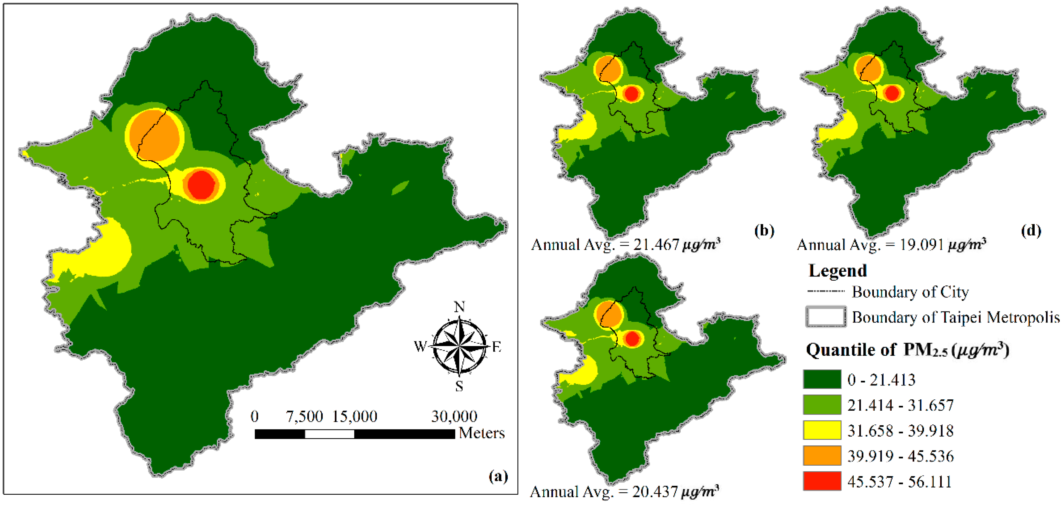
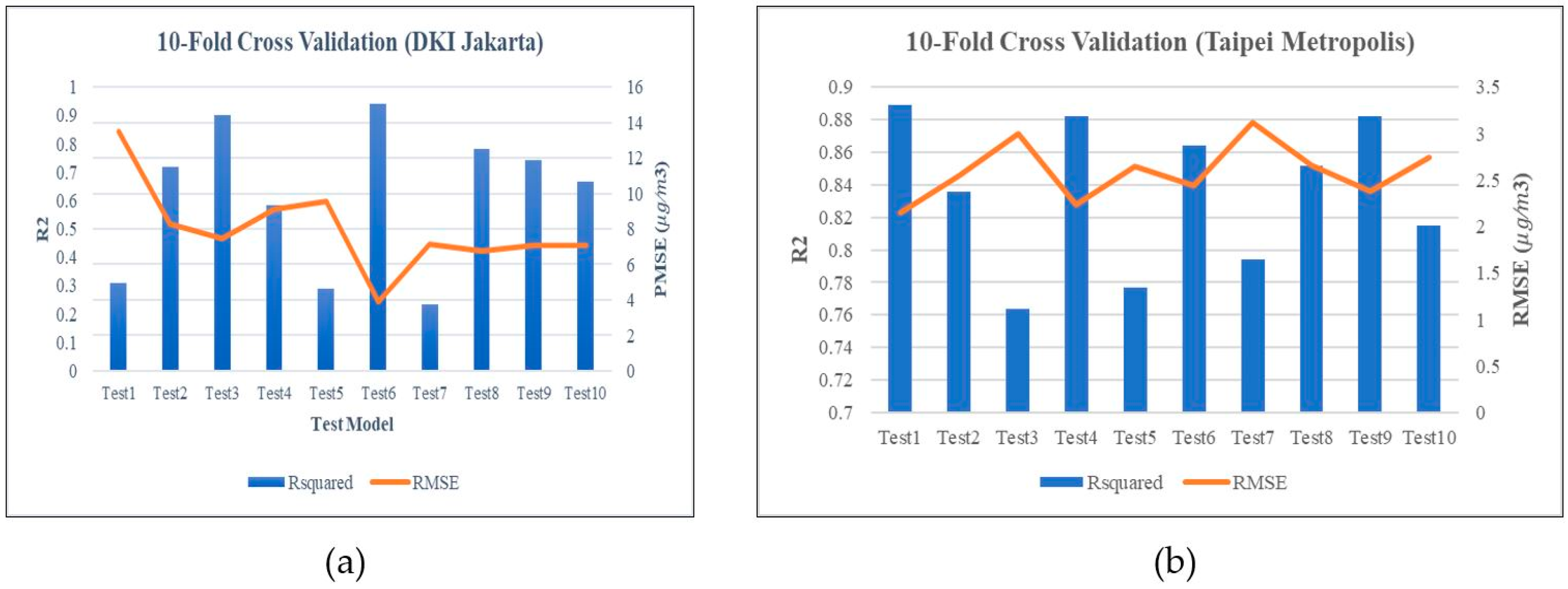
3.4. Model Validation
4. Discussion
5. Conclusions
Author Contributions
Funding
Acknowledgments
Conflicts of Interest
References
- Gurjar, B.R.; Jain, A.; Sharma, A.; Agarwal, A.; Gupta, P.; Nagpure, A.S.; Lelieveld, J. Human health risks in megacities due to air pollution. Atmos. Environ. 2010, 44, 4606–4613. [Google Scholar] [CrossRef]
- WHO. Health Effects of Particulate Matter; WHO Eropa: Copenhagen, Denmark, 2013. [Google Scholar]
- West, J.J.; Cohen, A.; Dentener, F.; Brunekreef, B.; Zhu, T.; Armstrong, B.; Bell, M.L.; Brauer, M.; Carmichael, G.; Costa, D.L.; et al. What We Breathe Impacts Our Health: Improving Understanding of the Link between Air Pollution and Health. Environ. Sci. Technol. 2016, 50, 4895–4904. [Google Scholar] [CrossRef] [PubMed]
- Puett, R.C.; Hart, J.E.; Yanosky, J.D.; Spiegelman, D.; Wang, M.; Fisher, J.A.; Hong, B.; Laden, F. Particulate Matter Air Pollution Exposure, Distance to Road, and Incident Lung Cancer in the Nurses’ Health Study Cohort. Environ. Health Perspect. 2014, 122, 926–932. [Google Scholar] [CrossRef] [PubMed]
- Liu, Y.; Paciorek, C.J.; Koutrakis, P. Estimating regional spatial and temporal variability of PM2.5 concentrations using satellite data, meteorology, and land use information. Environ. Health Perspect. 2009, 117, 886–892. [Google Scholar] [CrossRef]
- Zhang, G.; Rui, X.; Fan, Y. Critical review of methods to estimate PM 2.5 concentrations within specified research region. ISPRS Int. J. Geo-Inf. 2018, 7, 368. [Google Scholar]
- Li, L.; Gong, J.; Zhou, J. Spatial interpolation of fine particulate matter concentrations using the shortest wind-field path distance. PLoS ONE 2014, 9, e96111. [Google Scholar] [CrossRef]
- Beelen, R.; Hoek, G.; Pebesma, E.; Vienneau, D.; de Hoogh, K.; Briggs, D.J. Mapping of background air pollution at a fine spatial scale across the European Union. Sci. Total Environ. 2009, 407, 1852–1867. [Google Scholar] [CrossRef]
- Shairsingh, K.K.; Jeong, C.H.; Wang, J.M.; Brook, J.R.; Evans, G.J. Urban land use regression models: Can temporal deconvolution of traffic pollution measurements extend the urban LUR to suburban areas? Atmos. Environ. 2019, 196, 143–151. [Google Scholar] [CrossRef]
- Xu, S.; Zou, B.; Lin, Y.; Zhao, X.; Li, S.; Hu, C. Strategies of Method Selection for Fine Scale PM2.5 mapping in Intra-Urban Area Under Crowdsourcing Monitoring. Atmos. Meas. Tech. 2019, 12, 2933–2948. [Google Scholar] [CrossRef]
- Lee, J.H.; Wu, C.F.; Hoek, G.; de Hoogh, K.; Beelen, R.; Brunekreef, B.; Chan, C.C. LUR models for particulate matters in the Taipei metropolis with high densities of roads and strong activities of industry, commerce and construction. Sci. Total Environ. 2015, 514, 178–184. [Google Scholar] [CrossRef]
- Hsu, C.-Y.; Wu, C.-D.; Hsiao, Y.-P.; Chen, Y.-C.; Chen, M.-J.; Lung, S.-C.C. Developing Land-Use Regression Models to Estimate PM2.5-Bound Compound Concentrations. Remote Sens. 2018, 10, 1971. [Google Scholar] [CrossRef]
- Eeftens, M.; Beelen, R.; de Hoogh, K.; Bellander, T.; Cesaroni, G.; Cirach, M.; Declercq, C.; Dėdelė, A.; Dons, E.; de Nazelle, A.; et al. Development of land use regression models for PM 2.5, PM 2.5 absorbance, PM 10 and PM coarse in 20 European study areas; Results of the ESCAPE project. Environ. Sci. Technol. 2012, 46, 11195–11205. [Google Scholar] [CrossRef] [PubMed]
- Yang, H.; Chen, W.; Liang, Z. Impact of land use on PM2.5 pollution in a representative city of middle China. Int. J. Environ. Res. Public Health 2017, 14, 462. [Google Scholar] [CrossRef] [PubMed]
- Berlyand, M.E. Prediction and Regulation of Air Pollution; Springer: Dordrecht, The Netherlands, 1991; p. 312. [Google Scholar]
- Kusumaningtyas, S.D.A.; Aldrian, E.; Wati, T.; Atmoko, D.; Sunaryo, S. The recent state of ambient air quality in Jakarta. Aerosol Air Qual. Res. 2018, 18, 2343–2354. [Google Scholar] [CrossRef]
- Huete, A.; Didan, K.; Miura, T.; Rodriguez, E.P.; Gao, X.; Ferreira, L.G. Overview of the radiometric and biophysical performance of the MODIS vegetation indices. Remote Sens. Environ. 2002, 83, 195–213. [Google Scholar] [CrossRef]
- Xiaoxia, S.; Zhengjun, L. Vegetation Cover Annual Changes Based on Modis/Terra Ndvi in the Three Gorges Reservoir. Area. Remote Sens. Spat. Inf. Sci. 2008, 37, 1397–1400. [Google Scholar]
- Wu, C.D.; Chen, Y.C.; Pan, W.C.; Zeng, Y.T.; Chen, M.J.; Guo, Y.L.; Lung, S.C. Land-use regression with long-term satellite-based greenness index and culture-specific sources to model PM2.5 spatial-temporal variability. Environ. Pollut. 2017, 224, 148–157. [Google Scholar] [CrossRef]
- Kualitas Udara, Informasi Konsentrasi Partikulat (PM2.5). Available online: https://www.bmkg.go.id/kualitas-udara/informasi-partikulat-pm25.bmkg. (accessed on 21 February 2019).
- MOI (Ministry of The Interior). Population for Township and District. 2019; pp. 1–14. Available online: https://www.moi.gov.tw/files/site_stuff/321/1/month/m1-07.xls (accessed on 21 February 2019).
- NLSC (Ministry of Land Surveying and Mapping). Statistics from 105 to 106 for Land Use Investigation of Taiwan. 2019. Available online: https://www.nlsc.gov.tw/LUI/Home/Content.aspx (accessed on 15 February 2019).
- Statistics of DKI Jakarta Province. DKI Jakarta Province in Figures. 2018. Available online: https://jakarta.bps.go.id/publication/2018/08/16/67d90391b7996f51d1c625c4/provinsi-dki-jakarta-dalam-angka-2018.html (accessed on 18 January 2019).
- Rushayati, S.B.; Prasetyo, L.B. Adaptation Strategy Toward Urban Heat Island at Tropical Urban Area. Procedia Environ. Sci. 2016, 33, 221–229. [Google Scholar] [CrossRef]
- Didan, K. MOD13Q1 MODIS/Terra Vegetation Indices 16-Day L3 Global 250m SIN Grid V006; NASA EOSDIS Land Process. DAAC: Sioux Falls, SD, USA, 2015. [Google Scholar] [CrossRef]
- Zhang, Z.; Wang, J.; Hart, J.E.; Laden, F.; Zhao, C.; Li, T.; Zheng, P.; Li, D.; Ye, Z.; Chen, K. National scale spatiotemporal land-use regression model for PM2.5, PM10 and NO2 concentration in China. Atmos. Environ. 2018, 192, 48–54. [Google Scholar] [CrossRef]
- World Health Organization. WHO air quality guidelines for particulate matter, ozone, nitrogen dioxide and sulfur dioxide; WHO Press: Geneva, Switzerland, 2006. [Google Scholar]
- Indonesian Government, Presiden republik indonesia,” Peratur. Pemerintah Republik Indones. Nomor 41 Tahun 1999 Tentang Pengendali. Pencemaran Udar. Available online: http://jdih.pom.go.id/produk/PERATURAN%20PEMERINTAH/PP_No_28_th_2004%20plus%20penjelasan.pdf (accessed on 12 May 2019).
- Park, S.H.; Ko, D.-W. Investigating the effects of the built environment on PM2.5 and PM10: A case study of Seoul Metropolitan city, South Korea. Sustainability 2018, 10, 4552. [Google Scholar] [CrossRef]
- Han, L.; Zhou, W.; Li, W. Increasing impact of urban fine particles (PM2.5) on areas surrounding Chinese cities. Sci. Rep. 2015, 5, 12467. [Google Scholar] [CrossRef] [PubMed]
- Tai, A.P.K.; Mickley, L.J.; Jacob, D.J. Correlations between fine particulate matter (PM2.5) and meteorological variables in the United States: Implications for the sensitivity of PM2.5 to climate change. Atmos. Environ. 2010, 44, 3976–3984. [Google Scholar] [CrossRef]
- Syafei, A.D.; Fujiwara, A.; Zhang, J. Spatial and Temporal Factors of Air Quality in Surabaya City: An Analysis based on a Multilevel Model. Soc. Behav. Sci. 2014, 138, 612–622. [Google Scholar] [CrossRef][Green Version]
- Verma, S.S.; Desai, B. Effect of Meteorological Conditions on Air Pollution of Surat City. J. Int. Environ. Appl. Sci. 2016, 8, 358–367. [Google Scholar]
- Chen, W.; Yan, L.; Zhao, H. Seasonal Variations of Atmospheric Pollution and Air Quality in Beijing. Atmosphere 2015, 6, 1753–1770. [Google Scholar] [CrossRef]
- Givoni, B. Impact of planted areas on urban environmental quality: A review. Atmos. Environ. 1991, 25, 289–299. [Google Scholar] [CrossRef]
- Rotatori, M.; Salvatori, R.; Salzano, R. Planning Air Pollution Monitoring Networks in Industrial Areas by Means of Remote Sensed Images and GIS Techniques. In Air Quality Monitoring, Assessment and Management; Mazzeo, N.A., Ed.; IntechOpen: London, UK, 2011. [Google Scholar]


| Variable | VIF | Partial R2 | Model Performance | ||
|---|---|---|---|---|---|
| Intercept | −60.566 | 0.360 | R2 = 0.56 | ||
| Temperature | 5.797 | <0.001 | 1.57 | 0.325 | ADJ R2 = 0.52 |
| NDVI1500 m | −77.419 | <0.001 | 1.07 | 0.098 | RMSE = 8.19 |
| NDVI4750 m | −54.467 | <0.05 | 1.04 | 0.044 | |
| NDVI1750 m | −50.729 | <0.01 | 1.20 | 0.27 | |
| Relative humidity | −0.779 | <0.005 | 1.82 | 0.36 | |
| Residential Area4250 m | 0.039 | <0.05 | 1.39 | 0.26 |
| Variable (Unit) | Min | Max | Standard Deviation | Variance | Medium (25–75% Percentile) |
|---|---|---|---|---|---|
| a NDVI1500 m | 1.43 × 10⁻¹ | 3.36 × 10⁻¹ | 5.27 × 10⁻² | 2.79 × 10⁻³ | 0.256 (2.00 × 10⁻¹–2.86 × 10⁻¹) |
| b NDVI1750 m | 1.08 × 10⁻¹ | 3.43 × 10⁻¹ | 5.99 × 10⁻² | 3.59 × 10⁻³ | 0.272 (2.29 × 10⁻¹–2.93 × 10⁻¹) |
| c NDVI4750 m | 1.35 × 10⁻¹ | 2.97 × 10⁻¹ | 4.22 × 10⁻² | 1.79 × 10⁻³ | 0.236 (1.91 × 10⁻¹–2.63 × 10⁻¹) |
| Relative humidity | 67.603 | 94.194 | 4.985 | 24.858 | 78.409 (75.741–80.981) |
| Temperature | 30.357 | 33.872 | 7.43 × 10⁻¹ | 0.5522 | 32.614 (32.085–32.897) |
| d Residential area4250 m | 337.099 | 451.852 | 57.778 | 3,338.41 | 394.476 (337.099–451.852) |
| Variable | VIF | Partial R2 | Model Performance | ||
|---|---|---|---|---|---|
| Intercept | 1.978 | 0.16 | R2 = 0.84 | ||
| PM10 | 0.302 | <0.001 | 2.37 | 0.56 | ADJ R2 = 0.84 |
| NO2 | 0.266 | <0.001 | 2.98 | 0.09 | RMSE = 2.57 |
| SO2 | 2.101 | <0.001 | 2.37 | 0.01 | |
| UV | −0.326 | <0.001 | 2.39 | 0.01 | |
| Rainfall | −0.074 | 0.07 | 1.16 | 0.001 | |
| Fall | −0.501 | 0.05 | 1.21 | 0.002 | |
| Spring | 1.828 | <0.001 | 1.94 | 0.001 | |
| Major Road250 m | 6.42 × 10⁻³ | <0.001 | 1.38 | 0.01 | |
| Railway4000 m | 1.151 | <0.001 | 1.51 | 0.02 | |
| Railway5000 m | 0.615 | <0.001 | 1.47 | 0.02 | |
| Airport2500 m | 0.092 | <0.001 | 1.75 | 0.11 | |
| Airport5000 m | 0.043 | <0.001 | 2.94 | 0.01 | |
| Airportnearest distance | −1.03 × 10⁻⁴ | <0.01 | 2.81 | 0.004 | |
| Quarryingsite5000 m | 0.346 | <0.001 | 1.29 | 0.003 | |
| NDVI4000 m | −4.46 × 10⁻⁴ | <0.001 | 1.56 | 0.01 |
| Variable (Unit) | Min | Max | Standard Deviation | Variance | Medium (25–75% Percentile) |
|---|---|---|---|---|---|
| PM10 | 7.1 | 58.3 | 8.79 | 77.2 | 33.6 (30–41.9) |
| NO2 | 2.8 | 34.1 | 4.6 | 21.2 | 19.2 (17.1–22.1) |
| SO2 | 1.73 | 4.11 | 0.457 | 0.21 | 2.75 (2.45–3.13) |
| UV | 1.83 | 10.62 | 2.35 | 5.51 | 5.9 (3.76–8.21) |
| Rainfall | 0.04 | 14.39 | 2.68 | 7.2 | 2.28 (1.38–3.89) |
| Fall | 0 | 1 | 0.434 | 0.189 | 0 (0–1) |
| Spring | 0 | 1 | 0.432 | 0.187 | 0 (0–0) |
| a Major Road250 m | 0 | 586.4 | 144.8 | 20,989 | 30.9 (0–123.4) |
| b Railway4000 m | 0 | 2.863 | 0.709 | 0.502 | 0.124 (0–0.622) |
| c Railway5000 m | 0 | 6.29 | 1.97 | 3.9 | 0.318 (0–0.875) |
| d Airport2500 m | 0 | 77.8 | 17.9 | 320.5 | 0 (0–0) |
| e Airport5000 m | 0 | 54.7 | 19.7 | 387 | 0 (0–8.12) |
| f Airportnearest distance | 1433 | 17,289 | 4431.3 | 19,636,747 | 7356 (4425.5–11,242) |
| g Quarryingsite5000 m | 0 | 5.73 | 1.33 | 1.77 | 0 (0–0.318) |
| h NDVI4000 m | 585 | 9985 | 1335.3 | 1,783,200 | 8826 (7985–NA) |
© 2019 by the authors. Licensee MDPI, Basel, Switzerland. This article is an open access article distributed under the terms and conditions of the Creative Commons Attribution (CC BY) license (http://creativecommons.org/licenses/by/4.0/).
Share and Cite
Kusuma, W.L.; Chih-Da, W.; Yu-Ting, Z.; Hapsari, H.H.; Muhamad, J.L. PM2.5 Pollutant in Asia—A Comparison of Metropolis Cities in Indonesia and Taiwan. Int. J. Environ. Res. Public Health 2019, 16, 4924. https://doi.org/10.3390/ijerph16244924
Kusuma WL, Chih-Da W, Yu-Ting Z, Hapsari HH, Muhamad JL. PM2.5 Pollutant in Asia—A Comparison of Metropolis Cities in Indonesia and Taiwan. International Journal of Environmental Research and Public Health. 2019; 16(24):4924. https://doi.org/10.3390/ijerph16244924
Chicago/Turabian StyleKusuma, Widya Liadira, Wu Chih-Da, Zeng Yu-Ting, Handayani Hepi Hapsari, and Jaelani Lalu Muhamad. 2019. "PM2.5 Pollutant in Asia—A Comparison of Metropolis Cities in Indonesia and Taiwan" International Journal of Environmental Research and Public Health 16, no. 24: 4924. https://doi.org/10.3390/ijerph16244924
APA StyleKusuma, W. L., Chih-Da, W., Yu-Ting, Z., Hapsari, H. H., & Muhamad, J. L. (2019). PM2.5 Pollutant in Asia—A Comparison of Metropolis Cities in Indonesia and Taiwan. International Journal of Environmental Research and Public Health, 16(24), 4924. https://doi.org/10.3390/ijerph16244924