Article

Distribution, Sources and Water Quality Evaluation of the Riverine Solutes: A Case Study in the Lancangjiang River Basin, Tibetan Plateau

Institute of Earth Sciences, China University of Geosciences (Beijing), Beijing 100083, China
*
Author to whom correspondence should be addressed.
Int. J. Environ. Res. Public Health 2019, 16(23), 4670; https://doi.org/10.3390/ijerph16234670
Submission received: 27 October 2019 / Revised: 20 November 2019 / Accepted: 21 November 2019 / Published: 23 November 2019

Abstract

:
To examine the chemical composition, potential sources of solutes, and water quality of Lancangjiang River, the concentrations of major ions (Ca2+, Mg2+, Na+, K+, HCO3, SO42−, Cl and NO3) in 45 river water samples collected in July and August 2019 were determined. Ca2+ and HCO3 are the predominant ions in river water. The extremely low K+ and NO3 concentrations and the sparse population suggest that the anthropogenic inputs are limited. The Pearson correlation coefficients and the elemental ratios Ca2+/Na+ versus Mg2+/Na+, Ca2+/Na versus HCO3/Na+, [Ca2+ + Mg2+]/[HCO3] versus [SO42−]/[HCO3] reveal the mixing processes of different sources; the chemical composition of the river water is controlled by the mixture of carbonate weathering, evaporite weathering and silicate weathering inputs. To quantify the contributions of atmospheric input and rock dissolution, the forward method is employed in this study, which is based on the mass balance equation. The calculation results suggest the carbonate weathering inputs and gypsum dissolution make up the majority of the riverine cations, while silicate weathering and halite dissolution constitutes a relatively small proportion, the contributions of the atmospheric input are limited. The fast dissolution rate of evaporite and carbonate minerals and their lithologic distributions should be the key factor. To evaluate the water quality for drinking and irrigation purposes, the drinking water quality guidelines and the calculated parameters were employed, including sodium adsorption ratio (SAR), soluble sodium percentage (Na%,) and residual sodium carbonate (RSC). The assessments indicate that the river waters in the middle-lower reaches are generally suitable for irrigation and drinking purpose, and will not lead to health and soil problems, such as soil compaction and salinization. While in the upper reaches, the dissolution of carbonate and gypsum minerals transport abundant ions into river water and the river waters are not appropriate to use directly. This result highlights that the water quality status can also be affected by natural weathering processes in the area without anthropogenic inputs, where the long-time monitoring of water quality is also necessary.

1. Introduction

River water is the important component of hydrosphere and draws great attention in geological and environmental research, for it constitutes the lateral channels transporting the territorial matters towards the ocean [1,2]. The riverine dissolved loads transported along river waters are derived from both natural processes and anthropogenic perturbations [3,4,5,6], among which the chemical weathering is considered as the dominant source [1,7,8]. Thus, estimating the contributions of the different minerals during chemical weathering to the riverine solutes can help researchers to better understand the chemical composition of river water and regular patterns of matter cycling [9,10]. The forward method based on the mass balance equations is a common and effective way to estimate the contributions of different sources [8,11,12,13]. Atmospheric inputs, silicate weathering, carbonate weathering, and evaporite dissolution can be determined by assuming the elemental ratios between the major ions.
As the water supplies for drinking, agricultural activities and industry, the river water, especially water quality gains wide public concern over the world [14,15], the concentrated solutes may not only result in serious environmental problems (e.g. eutrophication) [16], but also threaten the daily life of local residents [17,18]. The inappropriate water with high salinity and alkalinity used for irrigation may destroy soil aggregate structure, thus reduce the grain yields [19,20,21], additionally, drinking water with deleterious or toxic matters may cause health hazards for the residents [22,23].
Several studies have found that the natural weathering processes which transport abundant ions into the river water can significantly affect river water quality in the area with little anthropogenic perturbations [24,25,26]. The Lancangjiang River basin is a part of eastern Himalayan region and the Qinghai–Tibet Plateau (HQTP). As the Water Tower of Asia, the HQTP is characterized by the high elevation and little human activity [27,28]. Plenty of research has been done about the eastern Himalayan river system [13,27,28,29,30,31]; these previous studies focused on the weathering rates and CO2 consumption flux, because the CO2 sequestration during the chemical weathering is considered as the sink of atmospheric CO2 levels, and the Himalayan lift significantly increase the chemical weathering rates, which is a major driver of global climate change [32]. However, few studies have examined the water quality in Himalayan river system. As the abundant solutes derived from the weathering may cause environmental problems, a comprehensive water quality assessment to examine the environmental impact of the dissolved load is necessary. The main aims of this study are: (1) to examine the chemical composition of the Lancangjiang River water; (2) to distinguish the sources of the solutes and estimate their relative contributions; (3) to assess the Lancangjiang River water quality status. Knowledge of the hydrogeochemistry and water quality status can help us to better understand the geochemical processes to improve environmental management in the Lancangjiang River basin.

2. Materials and Methods

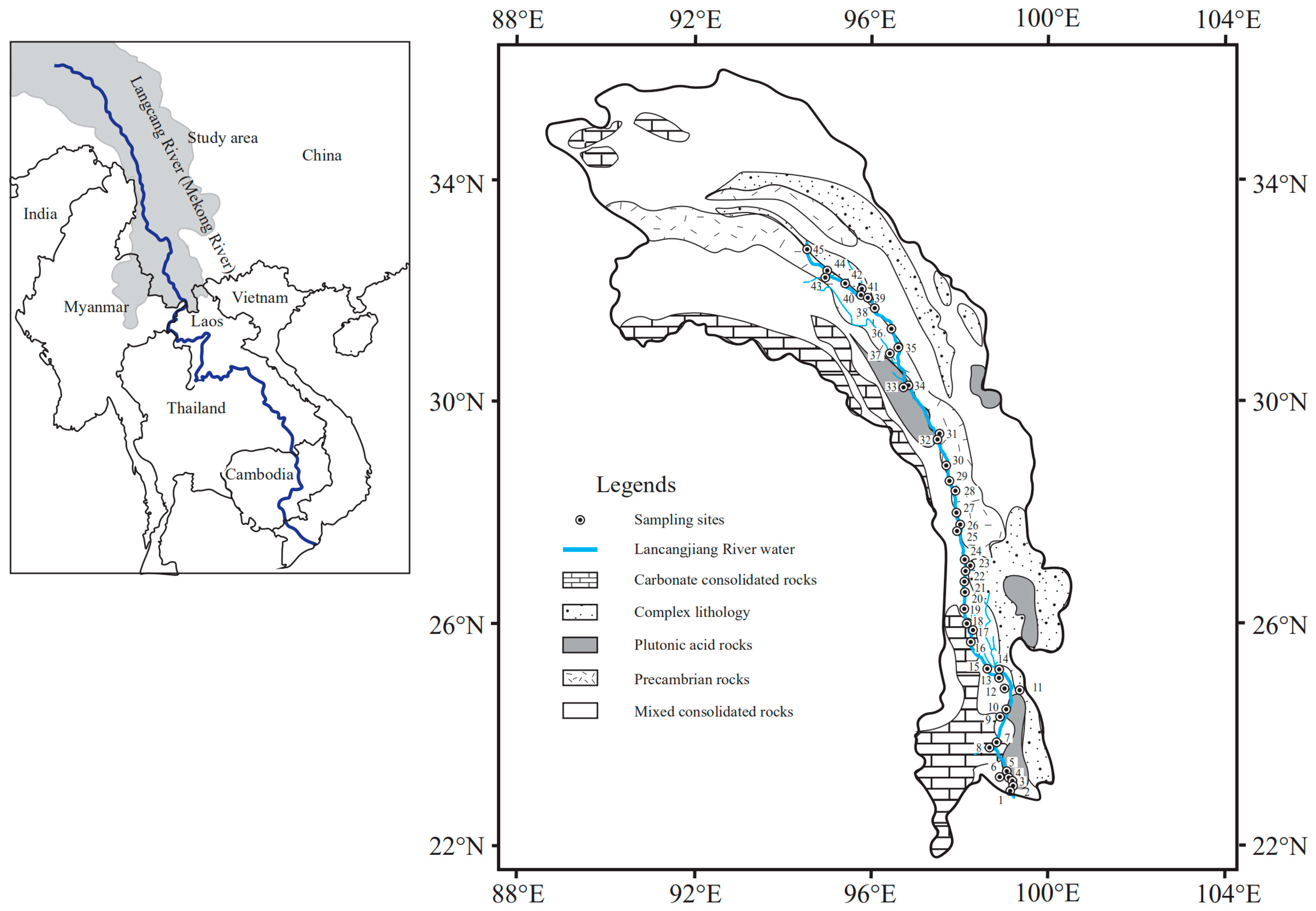
2.1. Study Area Description and Sample Collection

The study area is located in the eastern margin of the Tibetan Plateau, the collision of the Eurasian plates and Indian plates forged the steep valleys topography and elongated pattern of lithology in HQTP [33,34]. As showed in Figure 1, the lithology can be divided into several groups [35]: (1) carbonate consolidated rocks, including limestone, dolomite, and chalk, which make up more than 80% of the rock in study area; (2) complex lithology, encompassing sedimentary, volcanic rocks, metamorphic rocks and evaporites; (3) Plutonic acid rocks, including granite and diorite; (4) Precambrian rocks consisting of medium-highly granodioritic-granitic metamorphic rocks; (5) mixed consolidated rocks, typically sediments with 30%–70% carbonate minerals. The predominant minerals evaporites are halite and gypsum, which are scattered across the whole study area. Overall, the carbonate minerals make up approximately 65% of the lithologic composition in the study area, with silicate at 30% and evaporate at 5% [28].
Lancangjiang River (33°81′N–21°75′N and 94°40′E–101°15′E), which is the upper-middle reaches of Mekong River, originates from Tanggula Mountain with a drainage area of 167,400 km2, a length of 2160 km in China, and a mean annual discharge of 60 km3 per year [33]. The source area is located in the HQTP with a mean elevation of about 4500 m. In the upper reaches (Qinghai and Tibet province), the topography is characterized by high elevation (>3000 m) and deep valleys, the vegetation covering type is alpine steppe; while in lower reaches (Yunnan province), the vegetation covering type is subtropical forest, coniferous forest, and scrub meadow [13]. The Lancangjiang River Basin has a monsoon climate [29], leading to high rainfall in summer (>60% of the annual precipitation) with a mean annual precipitation of about 560 mm [13]. The mean air temperature is from −7 to 16 °C, with an average of 1 °C [28]. The human perturbations are considered limited because of the relatively scarce population compared to other provinces in China [29].

2.2. Sample Collection and Analysis

Forty-five river water samples were collected in Lancangjiang River in July and August in 2019: 30 samples were collected in mainstream, 12 samples in tributaries, 2 in the source area and 1 from industrial sewage, respectively. The location information of the sampling sites is presented in Figure 1 and Table S1. All the river samples were collected under a depth ~0.2 m from the center of the river on bridges or ferries. The collected river waters were filtered through 0.22-μm Millipore membrane (Whatman GF/F, pre-cleaned, General Electric Company(GE), Boston, MA, USA) within 24 h, then stored in precleaned polyethylene bottles. The river samples for cations measurement were acidified with 0.02 M HCl to pH < 2. All the containers were sealed and kept refrigerated at about 4 ℃ until further analysis.
The physical-chemical parameters of Lancangjiang River, including water temperature (T), pH, and electrical conductivity (EC) were immediately measured in the field by YSI-6920 (Xylem Inc., Yellow Springs, OH, USA). TA (total alkalinity) was titrated by HCl (0.03 M) in the field. The major anions (Cl, NO3, SO42−) were measured by ion chromatograph ICS-900 (DIONEX., Sunnyvale, CA, USA) in China University of Geoscience, Beijing (CUGB). Cations (Ca2+, Mg2+, Na+ and K+) were measured by ICP-OES (Optima 5300DV, PerkinElmer Inc., Waltham, MA, USA) in the Institute of Geographic Sciences and Nature Resources Research, Chinese Academy of Sciences (CAS). Replicate samples were measured to guarantee the accuracy of all the analysis, the relative standard deviations of all the analyses were within ± 5%. The results of analyses are presented in Table S1.
The correlation analyses are conducted by SPSS 19.0 software (SPSS Inc., Chicago, IL, USA) and the figures were completed with Origin 2018 (Origin Lab., Hampton, Massachusetts, MA, USA) and Adobe Illustrator (Adobe Inc., San Jose, CA, USA). The inorganic carbon species including HCO3, CO32−, H2CO3, and aqueous CO2 are calculated by using the program CO2SYS [36].

2.3. Mass Balance Model Calculation

In order to quantify the relative contributions of different sources, the forward method based on mass balance was employed [13]. The assumed mass balance equations can be written as Equations (1–6):
[Cl]riv = [Cl]atm + [Cl]evap
[SO42−]riv = [SO42−]rain+ [SO42−]evap
[Na+]riv =[Na+]rain + [Na+] evap + [Na+]sil
[K+]riv =[K+]rain + [K+]sil
[Ca2+]riv =[Ca2+]rain + [Ca2+] evap + [Ca2+]sil + [Ca2+]carb
[Mg2+]riv =[Mg2+]rain + [Mg2+]sil + [Mg2+]carb
where riv = river; sil = silicate; carb = carbonate; evap = evaporite, respectively. The procedure of calculating the contributions of these sources are shown in Figure 2.
First of all, the contributions of atmospheric inputs can be determined by the Cl concentrations. Because Cl is conservative in river, the Cl contents in river water derived from rain should keep the same level. The widely accepted method is assuming that the sample with the lowest Cl concentration acquired all its dissolved Cl completely from the atmospheric inputs, thus other ions derived from the rain can be calculated by the elemental ratio in rain [5,6,7,8,9,12,13,14]:
[X]rain = [Cl]lowest × (X/Cl)rain
where [X]rain is the element X concentrations in rain waters, [Cl]lowest is the concentrations of Cl which is assumed completely from the precipitation, (X/Cl)atm is the X/Cl molar ratio in rain waters. The sample LCJ-25 (Langcangjiang River-25) with the lowest Cl concentration (3.5 μmol/L) is collected in the tributaries in pristine areas, the bedrock in the sampling site LCJ-25 is Precambrian rocks consisting of medium-highly granodioritic-granitic metamorphic rocks, in which the chloride contents are limited.). These values is similar to the concentrations in rain in this study area (3.3 μmol/L [28], 2.9 μmol/L [37], respectively). In this study, the rain samples were not collected; the (X/Cl)atm used here are the long-time average values as reported in the previous study [37]. Then, the contributions of evaporite can be determined by assuming the Cl remaining after the atmospheric input correction are from halite, and all SO42− comes from gypsum dissolution. It is noteworthy that the estimated gypsum contributions here involve the sulfide, consequently, these contributions are the maximum limit of evaporite dissolution. Next, for the silicate fraction, all Na+ remaining after atmospheric input and evaporite dissolution while all K+ remaining after atmospheric input are assumed from silicate weathering. The predominant evaporites are halite and gypsum, the contributions of evaporites to riverine K+ are negligible. To estimate the contributions of silicate weathering to the riverine Mg2+, Ca2+, the molar ratios of Mg2+/Na+ and Ca2+/Na+ in the tributaries draining silicate terrains are employed. It is noteworthy that the molar ratios used here should not be that in silicate rocks, because erosion processes may fractionate these ratios. The Mg2+/Na+ and Ca2+/Na+ ratios are assumed to be 0.43 and 0.17, respectively (as reported in the previous study [29]). The Mg2+ and Ca2+ derived from the silicate weathering can be calculated by using these ratios and silicate-derived Na+ contents. Finally, the contribution of carbonate weathering can be simply calculated based on the mass balance: 100% - rain inputs% - evaporite weathering% - silicate weathering%, based on the mass balance. The contributions of anthropogenic inputs are limited (discussed in the next section). The results are shown in Table S2.

2.4. Water Quality Evaluation

Lancangjiang River is the major water supply (agricultural irrigation and drinking) for the local residents. In order to assess the suitability for irrigation and drinking purposes, the physicochemical parameters EC (electrical conductibility) and ion concentrations of the river waters are evaluated following drinking water quality guidelines (Chinese drinking water standards: GB 5749-2006 and WHO guidelines (WHO 2017)). The quality of irrigation water can affect soil quality attributes and further the crop yields [19,20,21]. The sodium hazard assessment for irrigation purpose is conducted by the calculated parameters including SAR, Na% and RSC. The detailed calculation processes are listed as Equations (8–10) [21]:
SAR = Na+×[2/(Ca2++Mg2+)]1/2
Na% = 100%×Na+/(Na++K++Ca2++Mg2+)
RSC = (HCO3 + CO32−) - (Ca2++Mg2+)
where the used ion concentrations are equivalent concentrations (meq/L). The results are shown in Table S2.

3. Results and Discussion

3.1. Hydrochemical Characteristics of the River Water

The data of physicochemical parameters and major ionic concentrations are shown in Table S1. The EC values varied from 81 to 2016 μS/cm with an average of 440 μS/cm. The river water temperature ranged from 8.4 to 28.6 °C with an average of 18.3 °C; the elevation of the sampling sites changes from 4604 m in the sources area to 527 m in the lower reaches, the variation of river water temperature reflects the elevations change. The pH ranged from 7.7 to 8.7 with an average of 8.3, indicating river waters are slightly alkaline. The pH value and water temperature predominate the form of dissolved inorganic carbon species, namely, the relative proportion of HCO3, CO32−, H2CO3, and aqueous CO2 [38], the concentrations of each proportion can be calculated by using TA, pH, and water temperature, the calculated results suggest that the bicarbonates (HCO3) make up more than 95% of the DIC (dissolved inorganic carbon); thus, in this study, the DIC is replaced by the HCO3 in the discussion section.
The ionic compositions of Lancangjiang River are exhibited as the piper diagrams (Figure 3). Ca2+ is the predominant cation in Lancangjiang River, which constitutes more than 50% of the total cations, Mg2+ and Na+ + K+ make up ~25%, respectively. The order of the anion concentrations is HCO3 > SO42− > Cl, the NO3 concentrations are much lower and make up less than 5% of the total anions. It is remarkable to note that the K+ concentrations are also low (<100 µmol/L)—generally, K+ and NO3 are considered vulnerable to pollution, especially the agricultural activities [25,39]. The low concentrations of K+ and NO3 suggest that the contributions of the agricultural activities are limited. The ionic absolute concentration of samples collected in industrial sewage (LCJ-9) is similar to it in other river samples, indicating that the anthropogenic inputs are negligible. The Ca2+, Mg2+, and HCO3, which are always unaffected by the pollution, are mainly derived from the CO2-related weathering processes [40,41]. The dominance of Ca2+, Mg2+ and HCO3 concentrations suggest that the carbonate/silicate weathering inputs contribute to the bulk of major ionic budgets. The Cl and SO42− concentrations vary at a relatively large range and the anthropogenic inputs are considered limited in the study area, revealing that there are likely other sources for the riverine Cl and SO42− except atmospheric inputs, the evaporite dissolution may also make up a fair proportion of the solutes, because of the exposure of evaporite minerals in the Lancangjiang River basin.

3.2. Relationship between the Major Ions

The results of the correlation analysis are shown in Table 1. The results show that Ca2+ are clearly correlated with Mg2+ and HCO3 (r = 0.959, p < 0.01; r = 0.839, p < 0.01, respectively), Mg2+ also exhibited significant correlations with HCO3 (r = 0.805, p < 0.01), indicating they may have the same sources. Na+ is significantly correlated with Cl while Ca2+ are significantly correlated with SO42−, which demonstrates the contributions of evaporite dissolution. These results reveal that a complex weathering process may occur in the watershed. However, the correlation analysis is disturbed by the dilution effect, namely the correlations observed may reflect the dilution by run-off rather than the source’s signals [7]. Compared to the absolute concentrations, the elemental ratios are the better tools to describe the mixture between different end-members, because the elemental ratios can eliminate dilution effect. The elemental ratios, such as Ca2+/Na+, Mg2+/Na+, in river water are partly inherited into rocks, thus the large differences of these ratios between the silicate minerals and carbonate minerals should be reflected in river water if the solutes are the mixture of silicate weathering and carbonate weathering. Similarly, the elemental ratios can reveal the specific mineral’s dissolution according to the stoichiometry. All of these employments are shown in the next section.

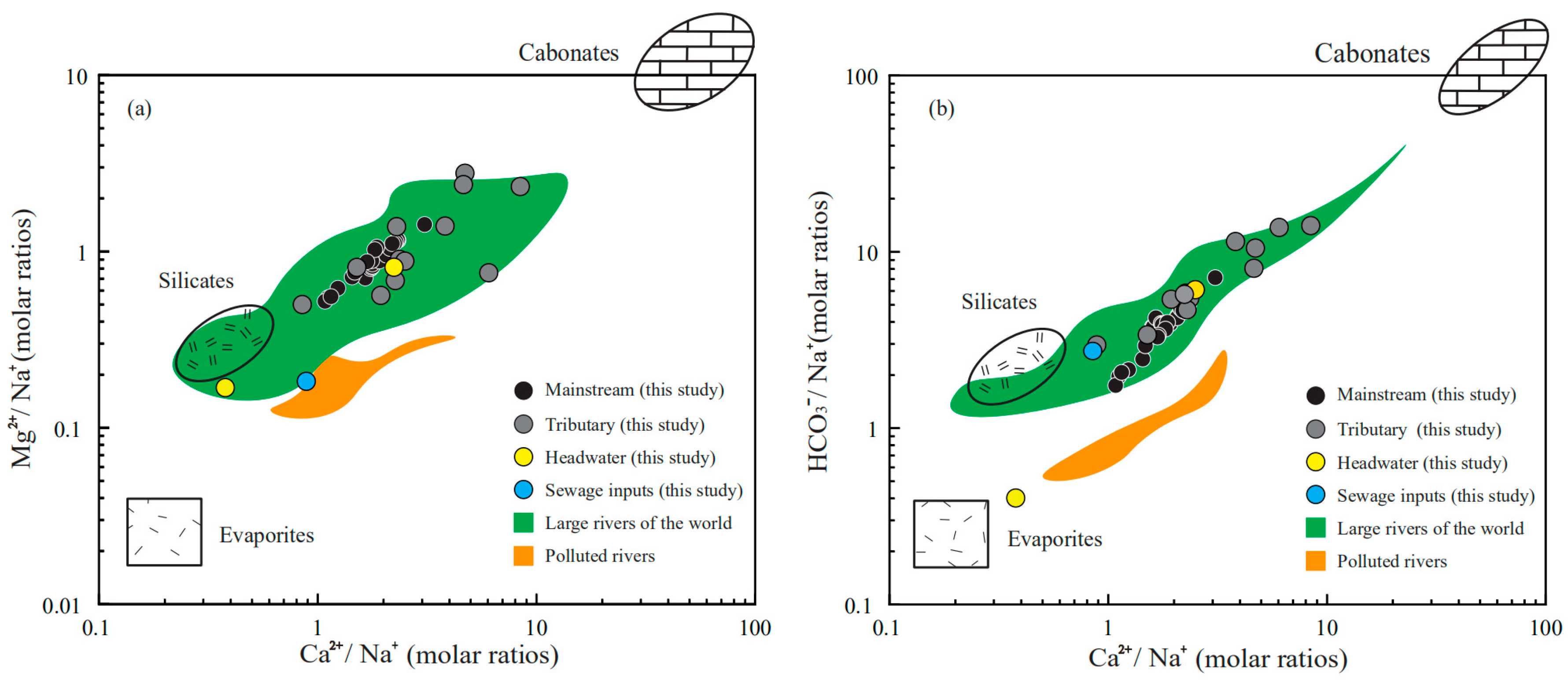
3.3. Stoichiometry of Weathering Processes

The elemental ratios Ca2+/Na+ versus Mg2+/Na+ and Ca2+/Na versus HCO3/Na+ can reflect the mixing of different lithologies [7]; the elemental ratios in river waters inherit that of the minerals. The assumed silicate end-members are Ca2+/Na+ = 0.35 ± 0.15, Mg2+/Na+ = 0.24 ± 0.15, HCO3/Na+ = 2 ± 0.5 while carbonate end-members are Ca2+/Na ≈ 50, Mg2+/Na+ ratios close to 10, HCO3/Na+ ≈ 50. The end-members used here were reported in previous studies [7]. For the evaporite, the end-members have a wide range and is characterized by the lowest Ca2+/Na+, Mg2+/Na+ and HCO3/Na+ values. As shown in Figure 4, all of the river water samples are distributed between the carbonate end-member and silicate/evaporite end-members, indicating the mixing of the weathering products. The samples collected in the industrial sewage inputs exhibit relatively low Ca2+/Na+, Mg2+/Na+ and HCO3/Na+ values—the most possible cause is that Na+ compared Ca2+ and Mg2+ constitute a relatively large proportion of cations in the sewage inputs [12,25]. The samples collected in the sources area show completely different chemical compositions, the sample LCJ-43 has conspicuously high Na+ and Cl contents, the sampling site is located in the pristine area without human disturbance, and the plot of Ca2+/Na versus HCO3/Na+ is close to the evaporite end-members, proving the large contributions of evaporite dissolutions. However, the ions in sample LCJ-45 are predominated by Ca2+, Mg2+ and HCO3, indicating the mixing of carbonate and silicate weathering. The variations of the chemical compositions in source area are closely related to the complex lithology.
The equivalent ratio between [Ca2+ + Mg2+]/[HCO3] and [SO42]/[HCO3] can trace the potential weathering processes, which can be summarized as Equations (11–16) [25,42]:
2CaxMg(1−x)CO3 + H2SO4 → 2XCa2+ + 2(1 − X)Mg2+ + 2HCO3 + SO42−
CaxMg(1−x)CO3 + H2O + CO2 → XCa2+ + (1 − X)Mg2+ + 2HCO3
2NaxK(1−x)AlSi3O8 + H2SO4 → 2Na+ + 2(1 − X)K+ + SO42− + 6SiO2 + 2AlOOH
2NaxK(1−x)AlSi3O8 + H2CO3 → 2Na+ + 2(1 − X)K+ + 2HCO3 + 6SiO2 + 2AlOOH
CaAl2Si2O8 + H2SO4 → Ca+ + SO42− + 2SiO2 + 2AlOOH
CaAl2Si2O8 + H2CO3 → Ca+ + 2HCO3 + 2SiO2 + 2AlOOH
According to the reaction equations, several ideal conditions can be obtained: (1) Carbonate are dissolved by the carbonic acid, as the generated HCO3 are derived from both the minerals and weathering agents. Thus, the [Ca2+ + Mg2+]/[HCO3] should be equivalent to 1, meanwhile the contributions of H2SO4 to dissolution should be limited, and [SO42−]/[HCO3] ratios should be close 0 (Equation 12). In fact, the anorthite weathering by carbonic acid causes the same [Ca2+ + Mg2+]/[HCO3] and [SO42−]/[HCO3] ratios; the difference is the generated HCO3 are completely from the weathering agents (Equation 16); (2) Carbonate minerals are dissolved only by the H2SO4, the [Ca2+ + Mg2+]/[HCO3] are equal to 2, [SO42−]/[HCO3] ratios should be close to 0, respectively; (3) The dissolution of alkaline feldspar by the carbonic acid will generate HCO3, Na+ + K+ the [Ca2+ + Mg2+]/[HCO3] and [SO42−]/[HCO3] ratios are close to 0; (4) The dissolution of anorthite minerals by sulfuric acid and gypsum dissolution will not fall in the specific point; this dissolution leads to [Ca2+ + Mg2+]/[SO42−] = 1—it will just look like a line that goes upward with slope 1. All of this mixing activity should create a linear mixture because of the same denominator. As shown in Figure 5, though the explanation is not unique, the contributions of alkaline feldspar dissolution should be limited, because most samples are far from this end-member.
There are two potential mixtures between: (1) Carbonate/anorthite dissolved by the carbonic acid and carbonate dissolved by sulfuric acid; (2) Carbonate/anorthite dissolved by the carbonic acid and anorthite minerals dissolved by sulfuric acid/gypsum dissolution. Certainly, the coincidence of these two conditions is also possible; however, in either condition, the contributions of carbonate mineral dissolution to solutes should make up a fair proportion. To further examine the contributions of different lithologies, the forward method is employed in the next discussion.

3.4. The Mixing Proportions

The results of the forward method are shown in Table S2, the relative proportions of different sources, including atmospheric input, halite dissolution input, gypsum dissolution input, silicate input and carbonate input are along the mainstream showed in Figure 6. The contributions of the atmospheric inputs are limited, varying from 1.5% to 5% in the mainstream. In some tributaries, the contributions are larger, reaching between 0.6% and 19.3%. The contributions of the halite in the mainstream varies from 4.1% to 26.3%, with an average value of 17.6%, while for that of silicate ranges between 11.7% and 33.5%, averaged 16.4%. The gypsum dissolution inputs make up a mean value of 31.9% of the total cations while the mean contribution of carbonate mineral dissolution is 30.9%. The samples in the last site can better represent the solute sources of the whole basin. In the sample site LCJ-1, 3.8% of the total cations are derived from the rain inputs, while the contributions of the halite dissolution, gypsum dissolution, silicate weathering and carbonate weathering make up 19.2%, 24.7%, 17.4% and 34.9% of the total cations, respectively. Similar to many studies [5,6,7,8,12,13], the carbonate weathering is the predominant sources of the riverine solutes. As mentioned before, the estimate regarding the contribution of gypsum should be the maximum value because this estimated contribution value involves the contribution of sulfate oxidation to the SO42. In order to get a better estimate, the data about the S, O isotopic composition in the QHTP rivers were collected [43]. The results suggest that the proportion of sulphate from the sulphate oxidation ranges between 16% and 72%. Thus, the relative proportion of sulphate from gypsum dissolution is at least 28% and the conservative estimate of the gypsum dissolution contribution is about 4% for the whole watershed.
Generally, these relative contributions are dominated by the dissolution rate and lithologic distribution of the watershed [44,45]; the order of dissolution rates (kinetics) is evaporite > carbonate > silicate [44,45,46,47]. Though the evaporite constitutes a small proportion of the bedrock, the fast dissolution rate enables a large proportion of evaporate dissolution. The sample LCJ-43 located in the source area has the largest contributions of halite input, the Na+/Cl ratio is 1.05, indicating that this calculation is reasonable. The predominance of Ca2+ in cations is attributed to the mixture of carbonate weathering and gypsum dissolution. The relative fast dissolution rate of these minerals transports abundant Ca2+ into the river water. The mixing relationship in Figure 5 can be interpreted by the mixture of carbonate dissolved by the carbonic acid and gypsum dissolution. As discussed previously, the contributions of the gypsum dissolution may be overestimated: the sulfide oxidization will produce sulfuric acid and take part in the rock dissolution processes [48,49], thus the actual contribution of carbonate weathering should be higher. The fluctuation of the contributions along the river direction reflect the lithology discharged by the mainstream and inflows of the tributaries

3.5. Drinking and Irrigation Water Quality Assessments

Lancangjiang River are agricultural, industrial and residential water sources for local residents in both China and Thailand. The drinking water quality guidelines (Chinese drinking water standards: GB 5749-2006 [50] and WHO guidelines [51] are shown in Table 2. The recommended pH varies between 6.5 and 8.5. Most river samples exhibit desirable pH values, however, some samples in the urban area have high pH values, which may result from the anthropogenic inputs. The TDS (total dissolved solids), F, Cl concentrations are within the respective limits, while the SO42− contents in the head water are close to the limit value, the SO42− concentration of sample LCJ-43 exceeds the recommended values, the sources area of Lancangjiang are in pristine areas, so the majority of SO42− are derived from gypsum dissolution. This result suggests the river water may also need treatment, even with a small amount of anthropogenic input.
The calculation results of the irrigation water quality including SAR, Na% and RSC values are shown in the Table 2. SAR and Na% values represent the sodium hazard to soil aggregates by irrigation; the majority of samples can be defined as the excellent or good quality (SAR < 1; Na% < 30%). The samples in the source area exceed the desirable limits, as the halite dissolution leads to the high SAR and Na% values. RSC as residual sodium carbonate should be lower than 1.25 for irrigation water [52] and the RSC values of all the samples are within the recommended values. Additionally, the USSL and Wilcox diagrams using the EC, Na% and SAR are shown in Figure 7, most of river waters are plotted in the area of C1S1, C2S1 in USSL diagram and in the ‘Excellent to Good’ zone in Wilcox diagram. The samples in the sources area exhibit higher EC values compared to the lower reaches; the sample LCJ-43 is unsuitable to irrigating.
For most sites, the river waters are suitable for drinking purpose and agricultural activities at present and will not lead to health and soil problems in terms of major ions. In the upper reaches of the Lanjiang river, the dissolutions of the evaporite and carbonate transport abundant ions into the river water and as a consequence, the river waters need cleaning before consumption. Thus, the monitoring of water quality should be a long and serious mission. However, all the above water quality assessments are based on major ions to judge whether the river water is suitable to use. The heavy metal elements and organic matters also need to be taken into account, thus more attention should be paid toward these factors in future studies.

4. Conclusions

The spatial distribution of the physicochemical parameters and major ions (Ca2+, Mg2+, Na+, K+, Cl, SO42−, HCO3) were measured. By employing the Pearson correlation coefficients and elemental ratios, the contributions of different sources were determined. The water quality for irrigation and drinking were evaluated. The conclusions can be summarized as follows:
(1)
The river water chemistry is controlled by mineral weathering rather than anthropogenic inputs. The concentration order of the anions is HCO3 > SO42− > Cl, while the order of cations is Ca2+ > Mg2+ > Na+ + K+. Most samples are of the HCO3-Ca·Mg type, the river waters are slightly alkaline, and water temperatures decrease as the elevation increases.
(2)
The employment of the elemental ratios indicates the mixing relationships between different rocks. The chemical composition of the river water is the mixture of carbonate weathering inputs, evaporite dissolution input and silicate weathering input. In the source area of Lancangjiang River, the complex lithology lead to a relatively large difference in the chemical composition of each tributary.
(3)
The forward method indicates that on the watershed scale, the contributions of the atmospheric inputs are limited (<5%), the gypsum dissolution and carbonate minerals dissolution make up ~60% of the total cation budgets (34.9% for carbonate weathering, 24.7% for gypsum dissolution, respectively), the silicate weathering constitutes 17.4% while the halite dissolution makes up 19.2% of the total cations. This result reflects the dissolution rates of different minerals and lithologic distributions, the predominance of the Ca2+ and HCO3 in river water results from both the wide distribution, and the fast dissolution rate of carbonate minerals
(4)
The water quality is generally suitable for irrigation and drinking purposes in terms of major ions. In the upper reaches of Lancangjiang River, the dissolution of gypsum and halite transport abundant Na+ and SO42− into river waters, and these contents exceed the recommended values, which may cause health and soil problems, such as soil compaction and salinization. This result suggests even in the pristine areas with little human disturbance, the water quality requires monitoring and assessment due to chemical weathering processes.

Supplementary Materials

The following are available online at https://www.mdpi.com/1660-4601/16/23/4670/s1. Table S1: The sampling locations and chemical compositions of the Lancangjiang River, Table S2: Calculation results of forward method and water quality.

Author Contributions

Conceptualization, G.H. and J.L.; Methodology, J.L.; Validation, J.L.; Formal analysis, J.L. and J.Z.; Investigation, J.L., J.Z., B.L., M.L. and R.Q.; Data curation, J.L.; Writing—original draft preparation, J.L. and G.H.; Writing—review and editing, G.H; Project administration, G.H.; Funding acquisition, G.H.

Funding

This research was funded jointly by the National Natural Science Foundation of China (No. 41661144029; 41325010).

Acknowledgments

The authors gratefully acknowledge Xiaoqiang Li from China University of Geosciences for his assistance with data analysis.

Conflicts of Interest

The authors declare no conflicts of interest.

References

  1. Meybeck, M. Global geochemical weathering of surficial rocks estimates from river dissolved loads. Am. J. Sci. 1987, 287, 401–428. [Google Scholar] [CrossRef]
  2. Suchet, P.A.; Probst, J.L.; Ludwig, W. Worldwide distribution of continental rock lithology: Implicationsfor the atmospheric/soil CO2 uptake for continental weathering and alkalinity river transport to the oceans. Glob. Biogeochem. Cycles 2003, 17. [Google Scholar] [CrossRef]
  3. Han, G.L.; Song, Z.L.; Tang, Y.; Wu, Q.X.; Wang, Z.R. Ca and Sr isotope compositions of rainwater from Guiyang city, Southwest China: Implication for the sources of atmospheric aerosols and their seasonal variations. Atmos. Environ. 2019, 214. [Google Scholar] [CrossRef]
  4. Ahearn, D.S.; Sheibley, R.W.; Dahlgren, R.A.; Anderson, M.; Johnson, J.; Tate, K.W. Land use and land cover influence on water quality in the last free-flowing river draining the western Sierra Nevada, California. J. Hydrol. 2005, 313, 234–247. [Google Scholar] [CrossRef]
  5. Liu, J.; Han, G.; Liu, X.; Liu, M.; Song, C.; Zhang, Q.; Yang, K.; Li, X. Impacts of Anthropogenic Changes on the Mun River Water: Insight from Spatio-Distributions and Relationship of C and N Species in Northeast Thailand. Int. J. Environ. Res. Public Health 2019, 16, 659. [Google Scholar] [CrossRef]
  6. Liu, J.; Han, G.; Liu, X.; Liu, M.; Song, C.; Yang, K.; Li, X.; Zhang, Q. Distributive Characteristics of Riverine Nutrients in the Mun River, Northeast Thailand: Implications for Anthropogenic Inputs. Water 2019, 11, 954. [Google Scholar] [CrossRef]
  7. Gaillardet, J.; Dupre, B.; Louvat, P.; Allegre, C.J. Global silicate weathering and CO2 consumption rates deduced from the chemistry of large rivers. Chem. Geol. 1999, 159, 3–30. [Google Scholar] [CrossRef]
  8. Moon, S.; Huh, Y.; Qin, J.; van Pho, N. Chemical weathering in the Hong (Red) River basin: Rates of silicate weathering and their controlling factors. Geochim. Cosmochim. Acta 2007, 71, 1411–1430. [Google Scholar] [CrossRef]
  9. Liu, J.K.; Han, G.L.; Liu, X.L.; Yang, K.H.; Li, X.Q.; Liu, M. Examining the Distribution and Variation of Dissolved Carbon Species and Seasonal Carbon Exports within the Jiulongjiang River Basin (Southeast China). J. Coast. Res. 2019, 35, 784–793. [Google Scholar] [CrossRef]
  10. Liu, Z.; Macpherson, G.L.; Groves, C.; Martin, J.B.; Yuan, D.; Zeng, S. Large and active CO2 uptake by coupled carbonate weathering. Earth-Sci. Rev. 2018, 182, 42–49. [Google Scholar] [CrossRef]
  11. Galy, A.; France-Lanord, C. Weathering processes in the Ganges-Brahmaputra basin and the riverine alkalinity budget. Chem. Geol. 1999, 159, 31–60. [Google Scholar] [CrossRef]
  12. Chetelat, B.; Liu, C.Q.; Zhao, Z.Q.; Wang, Q.L.; Li, S.L.; Li, J.; Wang, B.L. Geochemistry of the dissolved load of the Changjiang Basin rivers: Anthropogenic impacts and chemical weathering. Geochim. Cosmochim. Acta 2008, 72, 4254–4277. [Google Scholar] [CrossRef]
  13. Noh, H.; Huh, Y.; Qin, J.; Ellis, A. Chemical weathering in the Three Rivers region of Eastern Tibet. Geochim. Cosmochim. Acta 2009, 73, 1857–1877. [Google Scholar] [CrossRef]
  14. Li, P.; Wu, J. Drinking Water Quality and Public Health. Expo. Health 2019, 11, 73–79. [Google Scholar] [CrossRef]
  15. Wang, J.; Liu, G.; Liu, H.; Lam, P.K.S. Multivariate statistical evaluation of dissolved trace elements and a water quality assessment in the middle reaches of Huaihe River, Anhui, China. Sci. Total Environ. 2017, 583, 421–431. [Google Scholar] [CrossRef]
  16. Jaiswal, D.; Pandey, J. An ecological response index for simultaneous prediction of eutrophication and metal pollution in large rivers. Water Res. 2019, 161, 423–438. [Google Scholar] [CrossRef]
  17. Zhao, M.M.; Chen, Y.P.; Xue, L.G.; Fan, T.T.; Emaneghemi, B. Greater health risk in wet season than in dry season in the Yellow River of the Lanzhou region. Sci. Total Environ. 2018, 644, 873–883. [Google Scholar] [CrossRef]
  18. Zaric, N.M.; Deljanin, I.; Ilijevic, K.; Stanisavljevic, L.; Ristic, M.; Grzetic, I. Assessment of spatial and temporal variations in trace element concentrations using honeybees (Apis mellifera) as bioindicators. PeerJ 2018, 6. [Google Scholar] [CrossRef]
  19. Liu, M.; Han, G.; Zhang, Q. Effects of agricultural abandonment on soil aggregation, soil organic carbon storage and stabilization: Results from observation in a small karst catchment, Southwest China. Agric. Ecosyst. Environ. 2019, 288, 106719. [Google Scholar] [CrossRef]
  20. Li, P.; Tian, R.; Liu, R. Solute Geochemistry and Multivariate Analysis of Water Quality in the Guohua Phosphorite Mine, Guizhou Province, China. Expo. Health 2018, 11, 81–94. [Google Scholar] [CrossRef]
  21. Santacruz de León, G.; Ramos Leal, J.A.; Moran Ramirez, J.; Lopez Alvarez, B.; Santacruz De Leon, E.E. Quality indices of groundwater for agricultural use in the Soconusco, Chiapas, Mexico. Earth Sci. Res. J. 2017, 21, 117–127. [Google Scholar] [CrossRef]
  22. Wu, J.H.; Wang, L.; Wang, S.T.; Tian, R.; Xue, C.Y.; Feng, W.; Li, Y.H. Spatiotemporal variation of groundwater quality in an arid area experiencing long-term paper wastewater irrigation, northwest China. Environ. Earth Sci. 2017, 76. [Google Scholar] [CrossRef]
  23. Li, P.Y.; Wu, J.H.; Qian, H. Hydrochemical appraisal of groundwater quality for drinking and irrigation purposes and the major influencing factors: A case study in and around Hua County, China. Arab. J. Geosci. 2016, 9. [Google Scholar] [CrossRef]
  24. Zeng, J.; Yue, F.J.; Wang, Z.J.; Wu, Q.; Qin, C.Q.; Li, S.L. Quantifying depression trapping effect on rainwater chemical composition during the rainy season in karst agricultural area, southwestern China. Atmos. Environ. 2019, 218, 116998. [Google Scholar] [CrossRef]
  25. Xu, Z.; Liu, C.-Q. Chemical weathering in the upper reaches of Xijiang River draining the Yunnan–Guizhou Plateau, Southwest China. Chem. Geol. 2007, 239, 83–95. [Google Scholar] [CrossRef]
  26. Han., G.; Tang., Y.; Wu., Q.; Liu., M.; Wang, Z. Assessing Contamination Sources by Using Sulfur and Oxygen Isotopes of Sulfate Ions in Xijiang River Basin, Southwest China. J. Environ. Qual. 2019, 48. [Google Scholar] [CrossRef]
  27. Huang, X.; Sillanpaa, M.; Gjessing, E.T.; Vogt, R.D. Water quality in the Tibetan Plateau: Major ions and trace elements in the headwaters of four major Asian rivers. Sci. Total Environ. 2009, 407, 6242–6254. [Google Scholar] [CrossRef]
  28. Zhang, L.-L.; Zhao, Z.-Q.; Zhang, W.; Tao, Z.-H.; Huang, L.; Yang, J.-X.; Wu, Q.-X.; Liu, C.-Q. Characteristics of water chemistry and its indication of chemical weathering in Jinshajiang, Lancangjiang and Nujiang drainage basins. Environ. Earth Sci. 2016, 75, 506. [Google Scholar] [CrossRef]
  29. Wu, W.; Xu, S.; Yang, J.; Yin, H. Silicate weathering and CO2 consumption deduced from the seven Chinese rivers originating in the Qinghai-Tibet Plateau. Chem. Geol. 2008, 249, 307–320. [Google Scholar] [CrossRef]
  30. Qin, J.; Huh, Y.; Edmond, J.M.; Du, G.; Ran, J. Chemical and physical weathering in the Min Jiang, a headwater tributary of the Yangtze River. Chem. Geol. 2006, 227, 53–69. [Google Scholar] [CrossRef]
  31. Jiang, L.G.; Yao, Z.J.; Wang, R.; Liu, Z.F.; Wang, L.; Wu, S.S. Hydrochemistry of the middle and upper reaches of the Yarlung Tsangpo River system: Weathering processes and CO2 consumption. Environ. Earth Sci. 2015, 74, 2369–2379. [Google Scholar] [CrossRef]
  32. Raymo, M.E.; Ruddiman, W.F. Tectonic Forcing of Late Cenozoic Climate. Nature 1992, 359, 117–122. [Google Scholar] [CrossRef]
  33. Hallet, B.; Molnar, P. Distorted drainage basins as markers of crustal strain east of the Himalaya. J. Geophys. Res.-Sol. Earth 2001, 106, 13697–13709. [Google Scholar] [CrossRef]
  34. Wang, X.F.; Metcalfe, I.; Jian, P.; He, L.Q.; Wang, C.S. The Jinshajiang-Ailaoshan Suture Zone, China: Tectonostratigraphy, age and evolution. J. Asian Earth Sci. 2000, 18, 675–690. [Google Scholar] [CrossRef]
  35. Durr, H.H.; Meybeck, M.; Durr, S.H. Lithologic composition of the Earth’s continental surfaces derived from a new digital map emphasizing riverine material transfer. Glob. Biogeochem. Cycles 2005, 19. [Google Scholar] [CrossRef]
  36. CO2SYS, Program. Available online: https://ecology.wa.gov/Research-Data/Data-resources/Models-spreadsheets/ Modeling -the-environment/Models-tools-for-TMDLs (accessed on 23 November 2019).
  37. Zhang, D.D.; Peart, M.; Jim, C.Y.; He, Y.Q.; Li, B.S.; Chen, J.A. Precipitation chemistry of Lhasa and other remote towns, Tibet. Atmos. Environ. 2003, 37, 231–240. [Google Scholar] [CrossRef] [Green Version]
  38. Stumm, W.; Morgan, J.J. Aquatic Chemistry: An Introduction Emphasizing Chemical Equilibria in Natural Waters; Wiley: New York, NY, USA, 1981. [Google Scholar]
  39. Barnes, R.T.; Raymond, P.A. The contribution of agricultural and urban activities to inorganic carbon fluxes within temperate watersheds. Chem. Geol. 2009, 266, 318–327. [Google Scholar] [CrossRef]
  40. Roy, S.; Gaillardet, J.; Allegre, C.J. Geochemistry of dissolved and suspended loads of the Seine river, France: Anthropogenic impact, carbonate and silicate weathering. Geochim. Cosmochim. Acta 1999, 63, 1277–1292. [Google Scholar] [CrossRef]
  41. Ryu, J.-S.; Lee, K.-S.; Chang, H.-W.; Shin, H.S. Chemical weathering of carbonates and silicates in the Han River basin, South Korea. Chem. Geol. 2008, 247, 66–80. [Google Scholar] [CrossRef]
  42. Li, S.-L.; Calmels, D.; Han, G.; Gaillardet, J.; Liu, C.-Q. Sulfuric acid as an agent of carbonate weathering constrained by δ13CDIC: Examples from Southwest China. Earth Planet. Sci. Lett. 2008, 270, 189–199. [Google Scholar] [CrossRef]
  43. Li, S.-L.; Chetelat, B.; Yue, F.; Zhao, Z.; Liu, C.-Q. Chemical weathering processes in the Yalong River draining the eastern Tibetan Plateau, China. J. Asian Earth Sci. 2014, 88, 74–84. [Google Scholar] [CrossRef]
  44. Brantley, S. Kinetics of Mineral Dissolution. In Kinetics of Water-Rock Interaction; Brantley, S., Kubicki, J., White, A., Eds.; Springer: New York, NY, USA, 2008. [Google Scholar]
  45. Bluth, G.J.S.; Kump, L.R. Lithologic and Climatologic Controls of River Chemistry. Geochim. Cosmochim. Acta 1994, 58, 2341–2359. [Google Scholar] [CrossRef]
  46. White, A.F.; Bullen, T.D.; Vivit, D.V.; Schulz, M.S.; Clow, D.W. The role of disseminated calcite in the chemical weathering of granitoid rocks. Geochim. Cosmochim. Acta 1999, 63, 1939–1953. [Google Scholar] [CrossRef]
  47. Welch, S.A.; Ullman, W.J. The temperature dependence of bytownite feldspar dissolution in neutral aqueous solutions of inorganic and organic ligands at low temperature (5–35 °C). Chem. Geol. 2000, 167, 337–354. [Google Scholar] [CrossRef]
  48. Nightingale, M.; Mayer, B. Identifying sources and processes controlling the sulphur cycle in the Canyon Creek watershed, Alberta, Canada. Isot. Environ. Heath Stud. 2012, 48, 89–104. [Google Scholar] [CrossRef]
  49. Han, G.; Liu, C.-Q. Water geochemistry controlled by carbonate dissolution: A study of the river waters draining karst-dominated terrain, Guizhou Province, China. Chem. Geol. 2004, 204, 1–21. [Google Scholar] [CrossRef]
  50. China EPA. Environmental Quality Standards for Drinking Water Quality (GB 5749-2006). 2006. Available online: http://www.nhfpc.gov.cn/wjw/pgw/201212/33644.shtml (accessed on 1 July 2007).
  51. WHO. Guidelines for Drinking-Water Quality: Fourth Edition Incorporating the First Addendum; World Health Organization: Geneva, Switzerland, 2017; 631p. [Google Scholar]
  52. Li, P.Y.; Wu, J.H.; Qian, H. Assessment of groundwater quality for irrigation purposes and identification of hydro-geochemical evolution mechanisms in Pengyang County, China. Environ. Earth Sci. 2013, 69, 2211–2225. [Google Scholar] [CrossRef]
Figure 1. Sketch map showing the sampling sites, locations, lithology and river network of Lancangjiang River.
Ijerph 16 04670 g001
Figure 2. The outline of forward method calculation used in this study.
Ijerph 16 04670 g002
Figure 3. Piper diagrams showing the relative proportions of major ions in Lancangjiang River.
Ijerph 16 04670 g003
Figure 4. Mixing diagrams using: (a) Ca2+/Mg2+ versus Mg2+/Na+; (b) Ca2+/Mg2+ versus HCO3/Na+ molar ratios in the Lancangjiang River, the end-members values and data of large rivers and polluted river are from Gaillardet et al., 1999 [7].
Ijerph 16 04670 g004
Figure 5. Plots of the major ions: [SO42−]/[HCO3] versus [Ca2+ + Mg2+]/[HCO3] showing the weathering processes.
Ijerph 16 04670 g005
Figure 6. The calculated contributions of different sources to the riverine cations along the mainstream.
Ijerph 16 04670 g006
Figure 7. The assessment of irrigation water quality for alkalinity and salinity: (a) USSL diagram; (b) Wilcox diagram.
Ijerph 16 04670 g007
Table 1. Pearson correlation coefficients between major ions in the Lancangjiang River.
ParametersDICFClNO3SO42Ca2+K+Mg2+Na+EC
DIC1
F0.643 **1
Cl0.349 *0.306 *1
NO30.1470.1750.1421
SO420.664 **0.621 ***0.817 **−0.0061
Ca2+0.839 **0.731 **0.731 **0.0550.958 **1
K+0.337 *0.391 **0.693 **0.683 **0.531 **0.507 **1
Mg2+0.805 **0.657 **0.651 **0.0870.939 **0.959 **0.414 **1
Na+0.428 **0.365 *0.995 **0.1720.846 **0.780 **0.711 **0.694 **1
EC0.669 **0.552 **0.909 **0.1050.967 **0.946 **0.643 **0.894 **0.936 **1
* Significance at 0.05 probability level; ** Significance at 0.01 probability level.
Table 2. The chemical compositions of the river water and water quality guidelines.
ParametersMinMaxMeanSDChinese GuidelinesWHO Guideline
pH7.768.778.320.206.5–8.56.5–8.5
TDS (mg/L)52.7131328618910001000
F (mg/L)0.010.330.160.0611.5
Cl (mg/L)0.1333122.848.1250250
NO3-N (mg/L)0.052.840.640.4420 mg/L as N50
SO42− (mg/L)3.3745588.377.4250250
SAR0.084.310.580.61//
Na (%)7.1057.922.18.4//
RSC−7.040.39−1.181.22//

