Commuting Mode Choice in a High-Density City: Do Land-Use Density and Diversity Matter in Hong Kong?


Abstract
:1. Introduction
- Density. In neighborhoods with high residential density, destinations are often closer to a person’s home and therefore they can be reached by walking (Sun et al., 2016). Researchers have also argued that density is likely to be a proxy for low-income populations, better public transportation service, or low levels of car ownership [17,18].
- Diversity. Having diversified land use classes in the neighborhood can also promote walking and taking public transportation [19]. Diversity is often measured by the entropy value [20]. The job−housing balance—the ratio of employment to the residential population—is also alternatively used as a simpler measure (Rajamani et al., 2003; Bento et al., 2005).
- Design. Design includes the connectivity and quality of sidewalks [21]. More sophisticated measures of street-level configuration such as movement potential or network analysis have also been used in active travel and health studies [22,23]. Some studies have demonstrated the link between continuous sidewalks and a grid-like street pattern and propensity to walk or take public transit [3,4,17,24]. However, studies conducted in Beijing have found that a higher density of main roads increases the possibility of commuting by car [25].
- Destination accessibility. The distance to city center is often used to assess destination accessibility. The workplaces in many cities in China are largely located in traditional urban centers than at peripheries despite three decades of urban sprawl [26]. Residents are less prone to drive to their workplaces if living close to a city center [20,27].
2. Methods
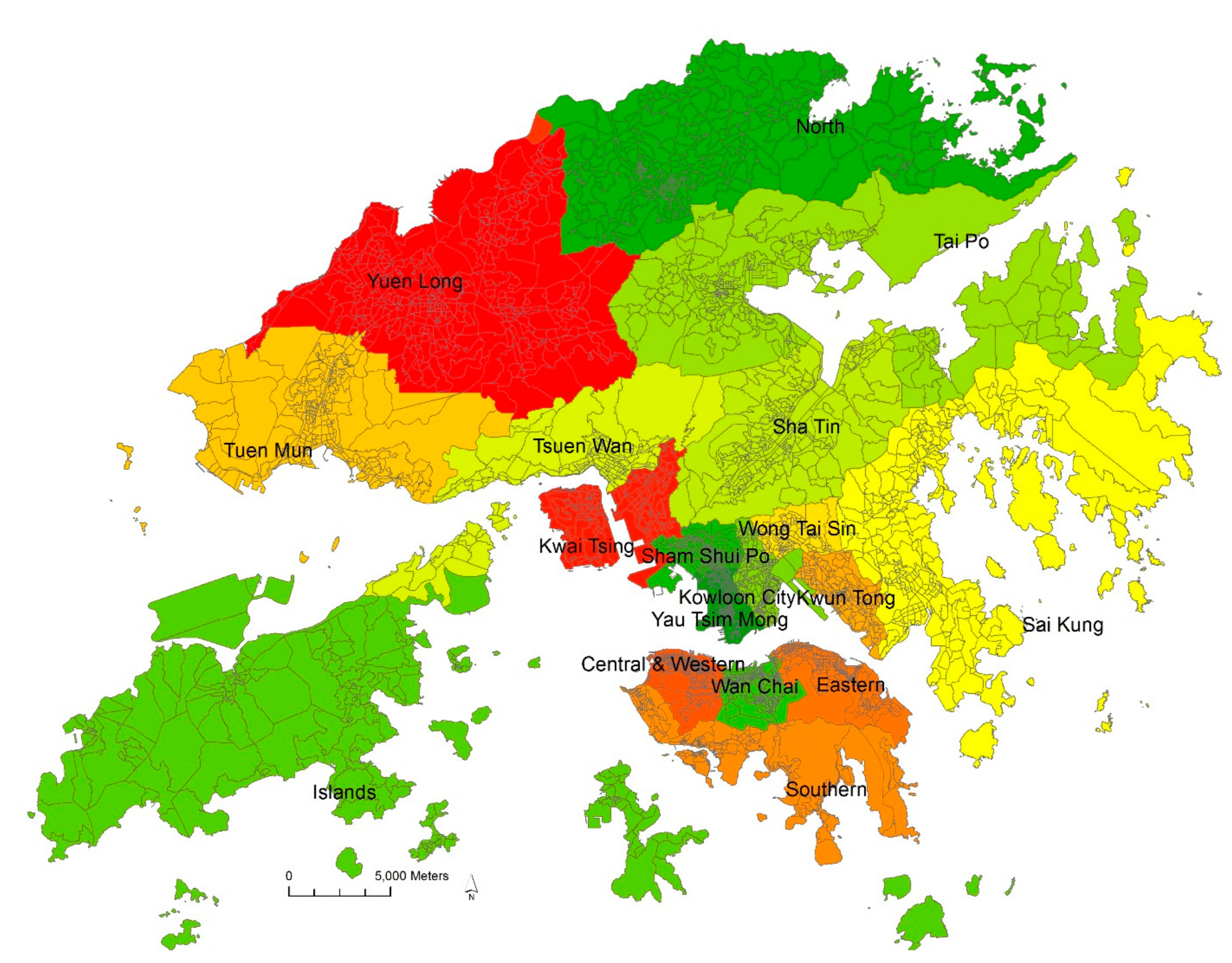
2.1. The Study Area: Hong Kong
2.2. Spatial Scales and Unit of Analysis
2.3. Outcome: Commuting Mode Choice
2.4. Built Environment Measures
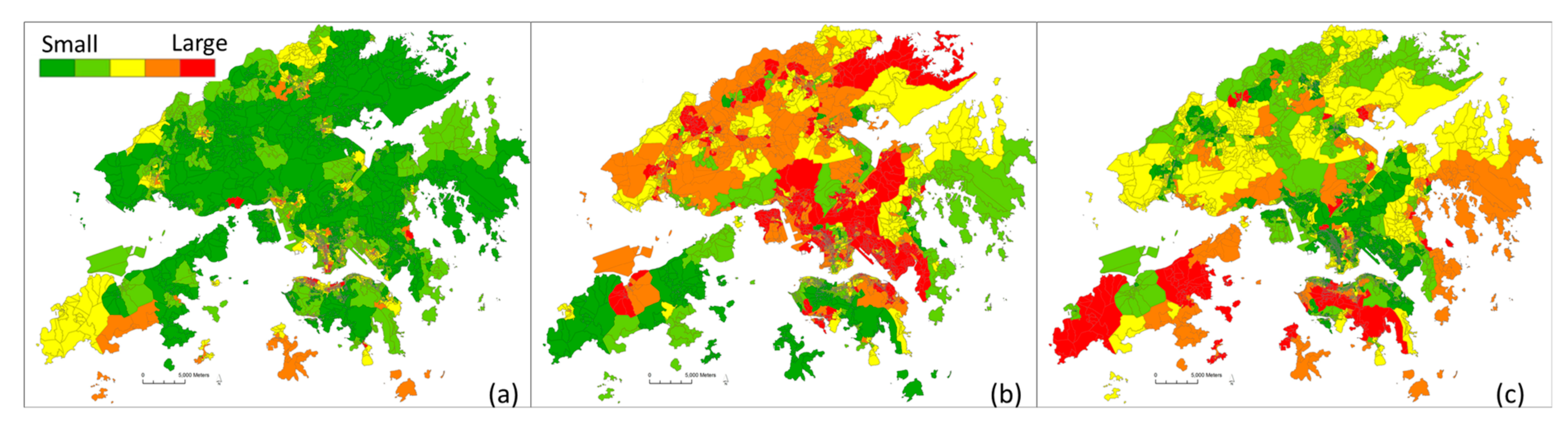
- Density. Job density and residential density were assessed as number of jobs and residents per unit area with a street block. This is a typical method of measuring gross density.
- Diversity. For detailed land use data were not available from the Hong Kong government; number of residents and jobs of different industries (retail, accommodation, and all other jobs) were used to calculate entropy score as a proxy of land-use mix [42]. Land-use mix = (−1) × [(b1/a) ln(b1/a) + (b2/a) ln(b2/a) + (b3/a) ln(b3/a) + (b4/a) ln(b4/a)]/ln (n4), in which b1 = number of residents, b2 = number of retail jobs, b3 = number of accommodation jobs, b4 = number of other jobs, a = total number of residents and jobs, and n4 = 0 through 4 depending on the number of different land uses present.
- Job−housing balance was also used, which was calculated as employment to population ratio.
- Destination accessibility. The distance to CBD was defined as the distance from the centroid of a street block to CBD of Hong Kong (the central area in the Hong Kong Island). The retail density was also assessed, which was defined as the number of supermarkets and convenience stores within an 800 m buffer from the centroid of a street block.
- Distance to transit stop. The walking distance to closest mass transit railway (MTR) station and number of bus stops within an 800 m buffer from the centroid of a street block were assessed.
2.5. Covariates
2.6. Data Analysis
3. Results
3.1. Descriptive Statistics
3.2. Multi-Level Modeling of Travel Choice
4. Discussion
Limitations and Strengths
5. Conclusions
Author Contributions
Funding
Conflicts of Interest
References
- Frank, L.; Bradley, M.; Kavage, S.; Chapman, J.; Lawton, T.K. Urban form, travel time, and cost relationships with tour complexity and mode choice. Transportation 2008, 35, 37–54. [Google Scholar] [CrossRef]
- Rodríguez, D.A.; Joo, J. The relationship between non-motorized mode choice and the local physical environment. Transp. Res. Part D: Transp. Environ. 2004, 9, 151–173. [Google Scholar]
- Schwanen, T.; Mokhtarian, P.L. What affects commute mode choice: Neighborhood physical structure or preferences toward neighborhoods? J. Transp. Geogr. 2005, 13, 83–99. [Google Scholar] [CrossRef]
- Zhang, M. The role of land use in travel mode choice: Evidence from Boston and Hong Kong. J. Am. Plan. Assoc. 2004, 70, 344–360. [Google Scholar] [CrossRef]
- Lovasi, G.S.; Schwartz-Soicher, O.; Quinn, J.W.; Berger, D.K.; Neckerman, K.M.; Jaslow, R.; Lee, K.K. Andrew Rundle Neighborhood safety and green space as predictors of obesity among preschool children from low-income families in New York City. Prev. Med. 2013, 57, 189–193. [Google Scholar] [CrossRef] [PubMed]
- Lovasi, G.S.; Jacobson, J.S.; Quinn, J.W.; Neckerman, K.M.; Ashby-Thompson, M.N.; Rundle, A. Is the environment near home and school associated with physical activity and adiposity of urban preschool children? J. Urban Health 2011, 88, 1143–1157. [Google Scholar] [CrossRef] [PubMed]
- Langlois, M.; Wasfi, R.A.; Ross, N.A.; El-Geneidy, A.M. Can transit-oriented developments help achieve the recommended weekly level of physical activity? J. Transp. Health 2016, 3, 181–190. [Google Scholar]
- Sung, H.; Lee, S.; Jung, S. Identifying the relationship between the objectively measured built environment and walking activity in the high-density and transit-oriented city, Seoul, Korea. Environ. Plan. B: Plan. Des. 2014, 41, 637–660. [Google Scholar] [CrossRef]
- Xiao, Y.; Li, Z.; Webster, C. Estimating the mediating effect of privately-supplied green space on the relationship between urban public green space and property value: Evidence from Shanghai, China. Land Use Policy 2016, 54, 439–447. [Google Scholar] [CrossRef]
- Xiao, Y.; Wang, Z.; Li, Z.; Tang, Z. An assessment of urban park access in Shanghai – Implications for the social equity in urban China. Landsc. Urban Plan. 2017, 157, 383–393. [Google Scholar] [CrossRef]
- Lu, Y.; Sarkar, C.; Ye, Y.; Xiao, Y. Using the Online Walking Journal to explore the relationship between campus environment and walking behaviour. J. Transp. Health 2017, 5, 123–132. [Google Scholar] [CrossRef]
- Gong, P.; Liang, S.; Carlton, E.J.; Jiang, Q.; Wu, J.; Wang, L.; Remais, J.V. Urbanisation and health in China. Lancet 2012, 379, 843–852. [Google Scholar] [CrossRef]
- National Bureau of Statistics of China. National Statistics Yearbook; National Bureau of Statistics of China: Beijing, China, 2017. [Google Scholar]
- Ng, S.W.; Norton, E.C.; Popkin, B.M. Why have physical activity levels declined among Chinese adults? Findings from the 1991–2006 China health and nutrition surveys. Soc. Sci. Med. 2009, 68, 1305–1314. [Google Scholar] [CrossRef] [PubMed]
- Ng, S.W.; Howard, A.G.; Wang, H.J.; Su, C.; Zhang, B. The physical activity transition among adults in China: 1991–2011. Obes. Rev. 2014, 15, 27–36. [Google Scholar] [CrossRef] [PubMed]
- Ewing, R.; Bartholomew, K.; Winkelman, S.; Walters, J.; Chen, D. Growing Cooler: The Evidence on Urban Development and Climate Change; Urban Land Institute: Washington, DC, USA, 2008. [Google Scholar]
- Cervero, R.; Kockelman, K. Travel demand and the 3Ds: Density, diversity, and design. Transp. Res. Part D: Transp. Environ. 1997, 2, 199–219. [Google Scholar] [CrossRef]
- Lee, C.; Moudon, A.V. Physical activity and environment research in the health field: Implications for urban and transportation planning practice and research. J. Plan. Liter. 2004, 19, 147–181. [Google Scholar]
- Saelens, B.E.; Handy, S.L. Built environment correlates of walking: A review. Med. Sci. Sports Exerc. 2008, 40 (Suppl. S7), S550–S556. [Google Scholar] [PubMed]
- Ewing, R.; Cervero, R. Travel and the built environment: A meta-analysis. J. Am. Plan. Assoc. 2010, 76, 265–294. [Google Scholar]
- Leslie, E.; Coffee, N.; Frank, L.; Owen, N.; Bauman, A.; Hugo, G. Walkability of local communities: Using geographic information systems to objectively assess relevant environmental attributes. Health Place 2007, 13, 111–122. [Google Scholar] [PubMed]
- Sarkar, C.; Gallacher, J.; Webster, C. Built environment configuration and change in body mass index: The Caerphilly Prospective Study (CaPS). Health Place 2013, 19, 33–44. [Google Scholar] [PubMed]
- Sarkar, C.; Webster, C.; Pryor, M.; Tang, D.; Melbourne, S.; Zhang, X.; Liu, J. Exploring associations between urban green, street design and walking: Results from the Greater London boroughs. Landsc. Urban Plan. 2015, 143, 112–125. [Google Scholar] [CrossRef]
- Badland, H.M.; Schofield, G.M.; Garrett, N. Travel behavior and objectively measured urban design variables: Associations for adults traveling to work. Health Place 2008, 14, 85–95. [Google Scholar] [CrossRef] [PubMed]
- Zhao, P. The impact of the built environment on individual workers’ commuting behavior in Beijing. Int. J. Sustain. Transp. 2013, 7, 389–415. [Google Scholar] [CrossRef]
- Næss, P. Residential location, travel behaviour, and energy use: Hangzhou metropolitan area compared to copenhagen. Indoor Built Environ. 2009, 18, 382–395. [Google Scholar] [CrossRef]
- Cervero, R. Mixed land-uses and commuting: Evidence from the American housing survey. Transp. Res. Part A: Policy Pract. 1996, 30 Pt A, 361–377. [Google Scholar] [CrossRef]
- Cervero, R.; Gorham, R. Commuting in transit versus automobile neighborhoods. J. Am. Plan. Assoc. 1995, 61, 210–225. [Google Scholar] [CrossRef]
- Dill, J. Evaluating a New Urbanist neighborhood. Berkeley Plan. J. 2006, 19, 59–78. [Google Scholar]
- Khattak, A.J.; Rodriguez, D. Travel behavior in neo-traditional neighborhood developments: A case study in USA. Transp. Res. Part A: Policy Pract. 2005, 39, 481–500. [Google Scholar] [CrossRef]
- Xue, C.Q. Hong Kong Architecture 1945–2015: From Colonial to Global; Springer: Singapore, 2016. [Google Scholar]
- Xue, C.Q.; Zou, H.; Li, B.; Hui, K.C. The shaping of early Hong Kong: Transplantation and adaptation by the British professionals, 1841–1941. Plan. Perspect. 2012, 27, 549–568. [Google Scholar] [CrossRef]
- Zhang, Y.; Li, Y.; Liu, Q.; Li, C. The Built Environment and Walking Activity of the Elderly: An Empirical Analysis in the Zhongshan Metropolitan Area, China. Sustainability 2014, 6, 1076–1092. [Google Scholar] [CrossRef]
- Su, M.; Tan, Y.; Liu, Q.; Ren, Y.; Kawachi, I.; Li, L.; Lv, J. Association between perceived urban built environment attributes and leisure-time physical activity among adults in Hangzhou, China. Prev. Med. 2014, 66, 60–64. [Google Scholar] [CrossRef] [PubMed]
- Lu, Y.; Xiao, Y.; Ye, Y. Urban density, diversity and design: Is more always better for walking? A study from Hong Kong. Prev. Med. 2016, 103, 99–103. [Google Scholar] [CrossRef] [PubMed]
- Lu, Y.; Gou, Z.; Xiao, Y.; Sarkar, C.; Zacharias, J. Do Transit-Oriented Developments (TODs) and Established Urban Neighborhoods Have Similar Walking Levels in Hong Kong? Int. J. Environ. Res. Public Health 2018, 15, 555. [Google Scholar] [CrossRef] [PubMed]
- Li, S.; Zhao, P. Exploring car ownership and car use in neighborhoods near metro stations in Beijing: Does the neighborhood built environment matter? Transp. Res. Part D: Transp. Environ. 2017, 56, 1–17. [Google Scholar] [CrossRef]
- Bristow, M.R. Hong Kong’s New Towns: A Selective Review; Oxford University Press: Hong Kong, China, 1989. [Google Scholar]
- Transport Department of Hong Kong. Registration and Deregistration of Private Cars; Transport Department of Hong Kong: Hong Kong, China, 2016. [Google Scholar]
- Census & Statistics Department of Hong Kong. 2011 Population Cencus. Available online: http://www.census2011.gov.hk/en/index.html (accessed on 10 October 2016).
- Centamap Company Limited. Online Map. Available online: http://hk.centamap.com (accessed on 10 October 2016).
- Frank, L.D.; Schmid, T.L.; Sallis, J.F.; Chapman, J.; Saelens, B.E. Linking objectively measured physical activity with objectively measured urban form: Findings from SMARTRAQ. Am. J. Prev. Med. 2005, 28 (Suppl. S2), 117–125. [Google Scholar] [CrossRef] [PubMed]
- Day, K. Built environmental correlates of physical activity in China: A review. Prev. Med. Rep. 2016, 3, 303–316. [Google Scholar] [CrossRef] [PubMed]
- Forsyth, A.; Oakes, J.M.; Schmitz, K.H.; Hearst, M. Does residential density increase walking and other physical activity? Urban Stud. 2007, 44, 679–697. [Google Scholar] [CrossRef]
- Glazier, R.H.; Creatore, M.I.; Weyman, J.T.; Fazli, G.; Matheson, F.I.; Gozdyra, P.; Moineddin, R.; Shriqui, V.K.; Booth, G.L. Density, Destinations or Both? A Comparison of Measures of Walkability in Relation to Transportation Behaviors, Obesity and Diabetes in Toronto, Canada. PLoS ONE 2014, 9, e91485. [Google Scholar] [CrossRef] [PubMed]
- Baum, C.F. Stata tip 63: Modeling proportions. Stata J. 2008, 8, 299–303. [Google Scholar]
- Papke, L.E.; Wooldridge, J.M. Econometric methods for fractional response variables with an application to 401(k) plan participation rates. J. Appl. Econom. 1996, 11, 619–632. [Google Scholar] [CrossRef]
- Field, A.P. Discovering Statistics Using SPSS, 2nd ed.; Sage Publications Inc.: London, UK; Thousand Oaks, CA, USA; Thousand Oaks, CA, USA, 2005; New Delhi, India. [Google Scholar]
- Cervero, R.; Murakami, J. Rail and Property Development in Hong Kong: Experiences and Extensions. Urban Stud. 2009, 46, 2019–2043. [Google Scholar] [CrossRef]

| Five Ds Framework | Built Environment Measures | Definition |
|---|---|---|
| Density | Job density a | Number of jobs per km2 in a TPU |
| Residential density | Number of residents per km2 in a street block | |
| Diversity | Land-use mix a,b | Entropy score of the number of residents and jobs in different industries (retail, accommodation, and all other jobs) in a TPU |
| Job−housing balance a | Ratio of job numbers to the resident numbers in a TPU | |
| Design | Street intersection density | Number of intersections (three-way and above) within an 800-m radius buffer from the centroid of a street block |
| Destination accessibility | Retail density | Number of supermarkets and convenience stores within an 800-m radius buffer from the centroid of a street block |
| Distance to the urban center | Walking distance from the centroid of a street block to urban center (Central in Hong Kong Island) | |
| Distance to transit stop | Distance to MTR station | Walking distance to closest MTR station |
| Bus stop density | Number of bus stops within an 800-m radius buffer from the centroid of a street block |
| Variables (Unit) | Mean | Standard Deviation | Minimum | Maximum |
|---|---|---|---|---|
| Commuting mode choice | ||||
| Walking (%) | 10.4 | 9.6 | 0.0 | 49.7 |
| Public transport (%) | 66.0 | 18.7 | 3.8 | 100.0 |
| Car (%) | 23.5 | 19.8 | 0.0 | 92.3 |
| SES characteristics | ||||
| Household income (HK$1000/month) | 33.38 | 31.58 | 5.06 | 256.25 |
| Education (% of college) | 30.5 | 15.6 | 0.3 | 87.5 |
| Nationality (% of Chinese) | 92.4 | 12.2 | 9.8 | 100.0 |
| Median age | 41.95 | 4.74 | 25.50 | 76.70 |
| Occupation (% of mangers or professionals) | 39.3 | 17.11 | 0.00 | 87.50 |
| Household size (persons) | 2.91 | 0.53 | 1.50 | 5.20 |
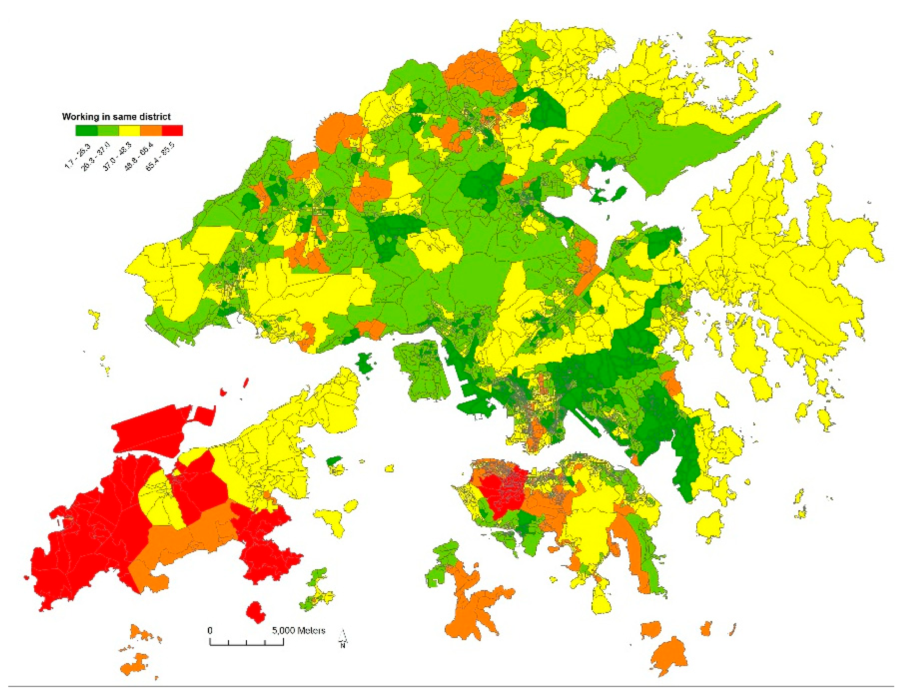
| Work in the same district (%) | 37.0 | 13.4 | 1.7 | 85.5 |
| Built environment | ||||
| Residential density (1000 people/km2) | 48.56 | 66.30 | 0.02 | 450.50 |
| Job density (1000 jobs/km2) | 24.03 | 45.62 | 0.00 | 289.60 |
| Job−housing balance (# of jobs /# of populations) | 1.53 | 9.29 | 0.00 | 119.06 |
| Land-use mix | 0.60 | 0.31 | 0.00 | 1.00 |
| Intersection density (# of intersections in buffer) | 120.59 | 85.04 | 0 | 348 |
| Distance to the urban center (km) | 11.54 | 8.46 | 0.06 | 40.74 |
| Retail density (# of retails in buffer) | 34.17 | 33.42 | 0 | 146 |
| Distance to metro station (km) | 1.71 | 2.37 | 0.01 | 23.58 |
| Bus stop density (# of bus stops in buffer) | 50.82 | 41.67 | 0 | 163 |
| Variables | Walking | p Value | Public Transport | p Value | Automobile | p Value |
|---|---|---|---|---|---|---|
| Beta Coefficents (SE) | Beta Coefficents (SE) | Beta Coefficents (SE) | ||||
| SES characteristics | ||||||
| Household income | −0.08 (0.01) | <0.01 | −0.23 (0.01) | <0.01 | 0.31 (0.01) | <0.01 |
| Education | 0.02 (0.02) | 0.13 | −0.02 (0.03) | 0.45 | −0.01 (0.03) | 0.81 |
| Nationality | −0.10 (0.01) | <0.01 | 0.20 (0.02) | <0.01 | −0.10 (0.02) | <0.01 |
| Median age | 0.02 (0.02) | 0.27 | −0.08 (0.03) | 0.02 | 0.06 (0.04) | 0.10 |
| Occupation | −0.07 (0.01) | <0.01 | 0.02 (0.02) | 0.38 | 0.05 (0.02) | 0.01 |
| Household size | −2.37 (0.23) | <0.01 | 0.58 (0.42) | 0.16 | 1.83 (0.42) | <0.01 |
| Work in same district | 0.27 (0.01) | <0.01 | −0.51 (0.02) | <0.01 | 0.23 (0.02) | <0.01 |
| Built environment | ||||||
| Residential density | 0.01 (<0.01) | <0.01 | 0.01 (<0.01) | <0.01 | −0.01 (<0.01) | <0.01 |
| Job density | 0.05 (<0.01) | <0.01 | −0.02 (<0.01) | <0.01 | −0.04 (0.01) | <0.01 |
| Land-use mix | 1.16 (0.35) | <0.01 | −1.50 (0.62) | 0.02 | 0.33 (0.63) | 0.59 |
| Job−housing balance | −0.09 (0.01) | <0.01 | 0.04 (0.02) | 0.06 | 0.05 (0.02) | 0.01 |
| Intersection density | 0.03 (<0.01) | <0.01 | −0.04 (0.01) | <0.01 | 0.01 (0.01) | 0.03 |
| Dis. to the urban center | −0.24 (<0.01) | <0.01 | 1.32 (0.07) | <0.01 | −1.02 (0.07) | <0.01 |
| Retail density | 0.12 (0.01) | <0.01 | 0.01 (0.01) | 0.37 | −0.14 (0.01) | <0.01 |
| Distance to MTR | <0.01 (<0.01) | 0.95 | −1.71 (0.10) | <0.01 | 1.68 (0.10) | <0.01 |
| Bus stop density | −0.05 (0.01) | <0.01 | 0.05 (0.01) | <0.01 | −0.01 (0.01) | 0.63 |
| Household income * Dis. to the urban center | −0.13(0.03) | <0.01 | -0.25 (0.02) | <0.01 | −0.08 (0.02) | <0.01 |
| Variables | Walking | Public Transport | Automobile |
|---|---|---|---|
| SES characteristics | |||
| Household income | −0.25 | −0.12 | 0.44 |
| Education | |||
| Nationality | −0.89 | 0.28 | −0.38 |
| Median age | −0.05 | ||
| Occupation | −0.26 | 0.09 | |
| Household size | −0.66 | 0.23 | |
| Work in the same district | 0.97 | −0.29 | 0.37 |
| Built environment | |||
| Job density | 0.12 | −0.01 | −0.04 |
| Residential density | 0.03 | 0.01 | −0.03 |
| Land-use mix | 0.07 | −0.01 | |
| Job−housing balance | −0.01 | 0.00 | |
| Intersection density | 0.33 | −0.08 | 0.06 |
| Distance to the urban center | −0.27 | 0.23 | −0.50 |
| Retail density | 0.41 | −0.20 | |
| Distance to metro station | −0.04 | 0.12 | |
| Bus stop density | −0.25 | 0.04 | |
© 2018 by the authors. Licensee MDPI, Basel, Switzerland. This article is an open access article distributed under the terms and conditions of the Creative Commons Attribution (CC BY) license (http://creativecommons.org/licenses/by/4.0/).
Share and Cite
Lu, Y.; Sun, G.; Sarkar, C.; Gou, Z.; Xiao, Y. Commuting Mode Choice in a High-Density City: Do Land-Use Density and Diversity Matter in Hong Kong? Int. J. Environ. Res. Public Health 2018, 15, 920. https://doi.org/10.3390/ijerph15050920
Lu Y, Sun G, Sarkar C, Gou Z, Xiao Y. Commuting Mode Choice in a High-Density City: Do Land-Use Density and Diversity Matter in Hong Kong? International Journal of Environmental Research and Public Health. 2018; 15(5):920. https://doi.org/10.3390/ijerph15050920
Chicago/Turabian StyleLu, Yi, Guibo Sun, Chinmoy Sarkar, Zhonghua Gou, and Yang Xiao. 2018. "Commuting Mode Choice in a High-Density City: Do Land-Use Density and Diversity Matter in Hong Kong?" International Journal of Environmental Research and Public Health 15, no. 5: 920. https://doi.org/10.3390/ijerph15050920
APA StyleLu, Y., Sun, G., Sarkar, C., Gou, Z., & Xiao, Y. (2018). Commuting Mode Choice in a High-Density City: Do Land-Use Density and Diversity Matter in Hong Kong? International Journal of Environmental Research and Public Health, 15(5), 920. https://doi.org/10.3390/ijerph15050920