The Uncertain Geographic Context Problem in the Analysis of the Relationships between Obesity and the Built Environment in Guangzhou


Abstract
1. Introduction
2. Contextual Uncertainties in Health Research
2.1. Neighborhood Effect on Obesity and Physical Activity
2.2. Delineations of Neighborhood Units
3. Study Area and Data
4. Methods
4.1. Social Survey
4.2. Built Environment Variables
4.3. Delineating Individuals’ Contextual Areas Using Activity Space
4.3.1. The Standard Deviational Ellipse
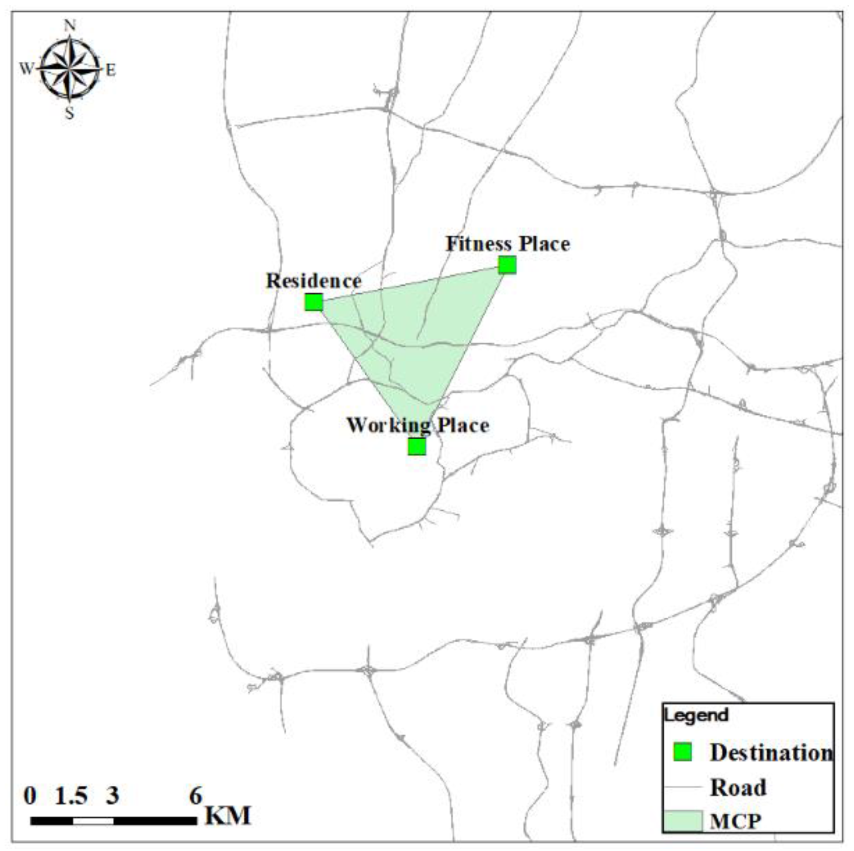
4.3.2. The Minimum Convex Polygon
4.3.3. The Road Network Buffer
4.4. Statistical Analysis
5. Analysis
5.1. Comparative Analysis of Activity Space Measures
5.2. Regression Analysis of Obesity
6. Discussion
7. Conclusions
Acknowledgments
Author Contributions
Conflicts of Interest
References
- Zhang, X.; Hua, L.; Holt, J.B. Modeling spatial accessibility to parks: A national study. Int. J. Health Geogr. 2011, 10, 1–14. [Google Scholar] [CrossRef] [PubMed]
- Ahima, R.S.; Lazar, M.A. The health risk of obesity—Better metrics imperative. Science 2013, 341, 856–858. [Google Scholar] [CrossRef] [PubMed]
- Lau, D.C.; Douketis, J.D.; Morrison, K.M.; Hramiak, I.M.; Sharma, A.M. 2006 Canadian clinical practice guidelines on the management and prevention of obesity in adults and children. Can. Med. Assoc. J. 2007, 176, 1–13. [Google Scholar] [CrossRef] [PubMed]
- Yamada, I.; Brown, B.B.; Smith, K.R.; Zick, C.D.; Kowaleski-Jones, L.; Fan, J.X. Mixed Land Use and Obesity: An Empirical Comparison of Alternative Land Use Measures and Geographic Scales. Prof. Geogr. 2012, 64, 157–177. [Google Scholar] [CrossRef] [PubMed]
- Wang, F.; Wen, M.; Xu, Y. Population-Adjusted Street Connectivity, Urbanicity and Risk of Obesity in the U.S. Appl. Geogr. 2013, 41, 1–14. [Google Scholar] [CrossRef] [PubMed]
- Xu, Y.; Wang, L. GIS-based analysis of obesity and the built environment in the US. Cartogr. Geogr. Inf. Sci. 2014, 42, 9–21. [Google Scholar] [CrossRef]
- Xu, Y.; Ming, W.; Wang, F. Multilevel built environment features and individual odds of overweight and obesity in Utah. Appl. Geogr. 2015, 60, 197–203. [Google Scholar] [CrossRef] [PubMed]
- Li, Y.; Carter, W.M.; Robinson, L.E. Social environmental disparities on children’s psychosocial stress, physical activity and weight status in Eastern Alabama counties. Appl. Geogr. 2016, 76, 106–114. [Google Scholar] [CrossRef]
- Townshend, T.; Lake, A. Obesogenic environments: Current evidence of the built and food environments. Perspect. Public Health 2017, 137, 38–44. [Google Scholar] [CrossRef] [PubMed]
- Davis, R.; Cook, D.; Cohen, L. A community resilience approach to reducing ethnic and racial disparities in health. Am. J. Public Health 2005, 95, 2168–2173. [Google Scholar] [CrossRef] [PubMed]
- Xu, Y.; Wang, F. Built environment and obesity by urbanicity in the U.S. Health Place 2015, 34, 19–29. [Google Scholar] [CrossRef] [PubMed]
- Feng, J.; Glass, T.A.; Curriero, F.C.; Stewart, W.F.; Schwartz, B.S. The built environment and obesity: A systematic review of the epidemiologic evidence. Health Place 2010, 16, 175–190. [Google Scholar] [CrossRef] [PubMed]
- Durand, C.P.; Andalib, M.; Dunton, G.F.; Wolch, J.; Pentz, M.A. A systematic review of built environment factors related to physical activity and obesity risk: Implications for smart growth urban planning. Obes. Rev. 2011, 12, E173–E182. [Google Scholar] [CrossRef] [PubMed]
- Ferdinand, A.O.; Sen, B.; Rahurkar, S.; Engler, S.; Menachemi, N. The relationship between built environments and physical activity: A systematic review. Am. J. Public Health 2012, 102, E7–E13. [Google Scholar] [CrossRef] [PubMed]
- Frank, L.D.; Andresen, M.A.; Schmid, T.L. Obesity relationships with community design, physical activity, and time spent in cars. Am. J. Prev. Med. 2004, 27, 87–96. [Google Scholar] [CrossRef] [PubMed]
- Rutt, C.D.; Coleman, K.J. Examining the relationships among built environment, physical activity, and body mass index in El Paso, TX. Prev. Med. 2005, 40, 831–841. [Google Scholar] [CrossRef] [PubMed]
- Gordon-Larsen, P.; Nelson, M.C.; Page, P.; Popkin, B.M. Inequality in the built environment underlies key health disparities in physical activity and obesity. Pediatrics 2006, 117, 417–424. [Google Scholar] [CrossRef] [PubMed]
- Smith, K.R.; Brown, B.B.; Yamada, I.; Kowaleski-Jones, L.; Zick, C.D.; Fan, J.X. Walkability and body mass index: Density, design, and new diversity measures. Am. J. Prev. Med. 2008, 35, 237–244. [Google Scholar] [CrossRef] [PubMed]
- Zick, C.D.; Smith, K.R.; Fan, J.X.; Brown, B.B.; Yamada, I.; Kowaleski-Jones, L. Running to the store? The relationship between neighborhood environments and the risk of obesity. Soc. Sci. Med. 2009, 69, 1493–1500. [Google Scholar] [CrossRef] [PubMed]
- Wen, M.; Kowaleski-Jones, L. The built environment and risk of obesity in the United States: Racial-ethnic disparities. Health Place 2012, 18, 1314–1322. [Google Scholar] [CrossRef] [PubMed]
- Cobb, L.K.; Appel, L.J.; Franco, M.; Jones-Smith, J.C.; Nur, A.; Anderson, C.A. The relationship of the local food environment with obesity: A systematic review of methods, study quality, and results. Obesity 2015, 23, 1331–1344. [Google Scholar] [CrossRef] [PubMed]
- Sun, B.; Yan, H.; Zhang, T. Built environmental impacts on individual mode choice and BMI: Evidence from China. J. Transp. Geogr. 2017, 63, 11–21. [Google Scholar] [CrossRef]
- Cook, T.D. The case for studying multiple contexts simultaneously. Addiction 2003, 98 (Suppl. 1), 151–155. [Google Scholar] [CrossRef] [PubMed]
- Cummins, S. Commentary: Investigating neighbourhood effects on health—Avoiding the ‘local trap’. Int. J. Epidemiol. 2007, 36, 355–357. [Google Scholar] [CrossRef] [PubMed]
- Matthews, S.A. The salience of neighborhood: Some lessons from sociology. Am. J. Prev. Med. 2008, 34, 257–259. [Google Scholar] [CrossRef] [PubMed]
- Kwan, M.-P. From place-based to people-based exposure measures. Soc. Sci. Med. 2009, 69, 1311–1313. [Google Scholar] [CrossRef] [PubMed]
- Kwan, M.-P. The uncertain geographic context problem. Ann. Assoc. Am. Geogr. 2012, 102, 958–968. [Google Scholar] [CrossRef]
- Kwan, M.-P. How GIS can help address the uncertain geographic context problem in social science research. Ann. GIS 2012, 18, 245–255. [Google Scholar] [CrossRef]
- Bernard, P.; Charafeddine, R.; Frohlich, K.L.; Daniel, M.; Kestens, Y.; Potvin, L. Health inequalities and place: A theoretical conception of neighbourhood. Soc. Sci. Med. 2007, 65, 1839–1852. [Google Scholar] [CrossRef] [PubMed]
- Jones, K.; Moon, G. Medical geography: Taking space seriously. Prog. Hum. Geogr. 1993, 17, 515–524. [Google Scholar] [CrossRef]
- Kearns, R.A. Place and health: Towards a reformed medical geography. Prof. Geogr. 1993, 45, 139–147. [Google Scholar] [CrossRef]
- Macintyre, S.; Ellaway, A. Ecological approaches: Rediscovering the role of the physical and social environment. Soc. Epidemiol. 2000, 9, 332–348. [Google Scholar]
- Macintyre, S.; Ellaway, A.; Cummins, S. Place effects on health: How can we conceptualise, operationalise and measure them? Soc. Sci. Med. 2002, 55, 125–139. [Google Scholar] [CrossRef]
- Sallis, J.F.; Cerin, E.; Conway, T.L.; Adams, M.A.; Frank, L.D.; Pratt, M.; Salvo, D.; Schipperijn, J.; Smith, G.; Cain, K.L.; et al. Physical activity in relation to urban environments in 14 cities worldwide: A cross-sectional study. Lancet 2016, 387, 2207–2217. [Google Scholar] [CrossRef]
- Cummins, S.; Stafford, M.; Macintyre, S.; Marmot, M.; Ellaway, A. Neighbourhood environment and its association with self-rated health: Evidence from Scotland and England. J. Epidemiol. Community Health 2005, 59, 207–213. [Google Scholar] [CrossRef] [PubMed]
- Arcury, T.A.; Gesler, W.M.; Preisser, J.S.; Sherman, J.; Spencer, J.; Perin, J. The effects of geography and spatial behavior on health care utilization among the residents of a rural region. Health Serv. Res. 2005, 40, 135–156. [Google Scholar] [CrossRef] [PubMed]
- Chaix, B. Geographic life environments and coronary heart disease: A literature review, theoretical contributions, methodological updates, and a research agenda. Public Health 2009, 30, 81–105. [Google Scholar] [CrossRef] [PubMed]
- Black, J.L.; Macinko, J. Neighborhoods and obesity. Nutr. Rev. 2008, 66, 2–20. [Google Scholar] [CrossRef] [PubMed]
- Berke, E.M.; Koepsell, T.D.; Moudon, A.V.; Hoskins, R.E.; Larson, E.B. Association of the built environment with physical activity and obesity in older persons. Am. J. Public Health 2007, 97, 486–492. [Google Scholar] [CrossRef] [PubMed]
- Boardman, J.D.; Saint Onge, J.M.; Rogers, R.G.; Denney, J.T. Race differentials in obesity: The impact of place. J. Health Soc. Behav. 2005, 46, 229–243. [Google Scholar] [CrossRef] [PubMed]
- Frank, L.D.; Saelens, B.E.; Powell, K.E.; Chapman, J.E. Stepping toward Causation: Do Built Environments or Neighborhood and Travel Preferences Explain Physical Activity, Driving, and Obesity? Soc. Sci. Med. 2007, 65, 1898–1914. [Google Scholar] [CrossRef] [PubMed]
- Grafova, I.B.; Freedman, V.A.; Kumar, R.; Rogowski, J. Neighborhoods and obesity in later life. Am. J. Public Health 2008, 98, 2065–2071. [Google Scholar] [CrossRef] [PubMed]
- Rundle, A.; Field, S.; Park, Y.; Freeman, L.; Weiss, C.C.; Neckerman, K. Personal and neighborhood socioeconomic status and indices of neighborhood walk-ability predict body mass index in New York City. Soc. Sci. Med. 2008, 67, 1951–1958. [Google Scholar] [CrossRef] [PubMed]
- Robert, S.A.; Reither, E.N. A multilevel analysis of race, community disadvantage, and body mass index among adults in the US. Soc. Sci. Med. 2004, 59, 2421–2434. [Google Scholar] [CrossRef] [PubMed]
- Brown, A.L.; Khattak, A.J.; Rodriguez, D.A. Neighbourhood Types, Travel and Body Mass: A Study of New Urbanist and Suburban Neighbourhoods in the US. Urban Stud. 2008, 45, 963–988. [Google Scholar] [CrossRef]
- Inagami, S.; Cohen, D.A.; Finch, B.K.; Asch, S.M. You are where you shop: Grocery store locations, weight, and neighborhoods. Am. J. Prev. Med. 2006, 31, 10–17. [Google Scholar] [CrossRef] [PubMed]
- Inagami, S.; Cohen, D.A.; Finch, B.K. Non-residential neighborhood exposures suppress neighborhood effects on self-rated health. Soc. Sci. Med. 2007, 65, 1779–1791. [Google Scholar] [CrossRef] [PubMed]
- Frank, L.D.; Schmid, T.L.; Sallis, J.F.; Chapman, J.; Saelens, B.E. Linking objectively measured physical activity with objectively measured urban form: Findings from SMARTRAQ. Am. J. Prev. Med. 2005, 28, 117–125. [Google Scholar] [CrossRef] [PubMed]
- Brownson, R.C.; Chang, J.J.; Eyler, A.A.; Ainsworth, B.E.; Kirtland, K.A.; Saelens, B.E.; Sallis, J.F. Measuring the environment for friendliness toward physical activity: A comparison of the reliability of 3 questionnaires. Am. J. Public Health 2004, 94, 473–483. [Google Scholar] [CrossRef] [PubMed]
- Kwan, M.P.; Peterson, R.D.; Browning, C.R.; Burrington, L.A.; Calder, C.A.; Krivo, L.J. Reconceptualizing sociogeographic context for the study of drug use, abuse, and addiction. In Geography and Drug Addiction; Springer: Dordrecht, The Netherlands, 2008; pp. 437–446. [Google Scholar]
- Golledge, R.G.; Stimson, R.J. Spatial Behavior: A Geographical Perspective; Guilford: New York, NY, USA, 1997. [Google Scholar]
- Zhou, S.; Liu, Y. The Situation and Transition of Jobs-housing Relocation in Guangzhou, China. Acta Geogr. Sin. 2010, 65, 191–201. [Google Scholar]
- Zhou, S.; Deng, L.; Kwan, M.P.; Yan, R. Social and spatial differentiation of high and low income groups’ out-of-home activities in Guangzhou, China. Cities 2015, 45, 81–90. [Google Scholar] [CrossRef]
- Sallis, J.F.; Floyd, M.F.; Rodríguez, D.A.; Saelens, B.E. Role of built environments in physical activity, obesity, and cardiovascular disease. Circulation 2012, 125, 729–737. [Google Scholar] [CrossRef] [PubMed]
- Flegal, K.M.; Carroll, M.D.; Ogden, C.L.; Curtin, L.R. Prevalence and Trends in Obesity among US Adults, 1999–2008. J. Am. Med. Assoc. 2010, 303, 235–241. [Google Scholar] [CrossRef] [PubMed]
- Cervero, R.; Kockelman, K. Travel demand and the 3Ds: Density, diversity, and design. Transp. Res. Part D 1997, 2, 199–219. [Google Scholar] [CrossRef]
- Christian, H.E.; Bull, F.C.; Middleton, N.J.; Knuiman, M.W.; Divitini, M.L.; Hooper, P.; Amarasinghe, A.; Giles-Corti, B. How important is the land use mix measure in understanding walking behaviour? Results from the RESIDE study. Int. J. Behav. Nutr. Phys. Act. 2011, 8, 69–72. [Google Scholar] [CrossRef] [PubMed]
- Cervero, R.; Sarmiento, O.L.; Jacoby, E.; Gomez, L.F.; Neiman, A. Influences of built environments on walking and cycling: Lessons from Bogotá. Int. J. Sustain. Transp. 2009, 3, 203–226. [Google Scholar] [CrossRef]
- James, P.; Berrigan, D.; Hart, J.E.; Hipp, J.A.; Hoehner, C.M.; Kerr, J.; Major, J.M.; Oka, M.; Laden, F. Effects of buffer size and shape on associations between the built environment and energy balance. Health Place 2014, 27, 162–170. [Google Scholar] [CrossRef] [PubMed]
- Chen, X.; Kwan, M.P. Contextual uncertainties, human mobility, and perceived food environment: The uncertain geographic context problem in food access research. Am. J. Public Health 2015, 105, 1734–1737. [Google Scholar] [CrossRef] [PubMed]
- Frank, L.D. Land Use and Transportation Interaction Implications on Public Health and Quality of Life. J. Plan. Educ. Res. 2000, 20, 6–22. [Google Scholar] [CrossRef]
- Sherman, J.E.; Spencer, J.; Preisser, J.S.; Gesler, W.M.; Arcury, T.A. A suite of methods for representing activity space in a healthcare accessibility study. Int. J. Health Geogr. 2005, 4. [Google Scholar] [CrossRef] [PubMed]
- Rainham, D.; Mcdowell, I.; Krewski, D.; Sawada, M. Conceptualizing the healthscape: Contributions of time geography, location technologies and spatial ecology to place and health research. Soc. Sci. Med. 2010, 70, 668–676. [Google Scholar] [CrossRef] [PubMed]
- Levine, N. CrimeStat III: A Spatial Statistics Program for the Analysis of Crime Incident Locations (Version 3.0); Ned Levine & Associates: Houston, TX, USA; National Institute of Justice: Washington, DC, USA, 2004.
- Zenk, S.N.; Schulz, A.J.; Matthews, S.A.; Odoms-Young, A.; Wilbur, J.; Wegrzyn, L.; Gibbs, K.; Braunschweig, C.; Stokes, C. Activity space environment and dietary and physical activity behaviors: A pilot study. Health Place 2011, 17, 1150–1161. [Google Scholar] [CrossRef] [PubMed]
- Ball, K.; Lamb, K.; Travaglini, N.; Ellaway, A. Street connectivity and obesity in Glasgow, Scotland: Impact of age, sex and socioeconomic position. Health Place 2012, 18, 1307–1313. [Google Scholar] [CrossRef] [PubMed]
- Boone-Heinonen, J.; Popkin, B.M.; Song, Y.; Gordon-Larsen, P. What neighborhood area captures built environment features related to adolescent physical activity? Health Place 2010, 16, 1280–1286. [Google Scholar] [CrossRef] [PubMed]
- Boruff, B.J.; Nathan, A.; Nijënstein, S. Using GPS technology to (re)-examine operational definitions of ‘neighbourhood’ in place-based health research. Int. J. Health Geogr. 2012, 11. [Google Scholar] [CrossRef] [PubMed]


| Socioeconomic Variables | Number of Participants | Percentage | |
|---|---|---|---|
| Gender (G) | Men | 203 | 50.4% |
| Women | 200 | 49.6% | |
| Age (A) | 18–29 | 91 | 22.6% |
| 30–40 | 110 | 27.3% | |
| 41–50 | 114 | 28.3% | |
| 51–65 | 46 | 11.4% | |
| 65+ | 42 | 10.4% | |
| Education (E) | High school or below | 165 | 40.9% |
| Technical school | 59 | 14.6% | |
| Junior college | 103 | 25.6% | |
| College or high | 76 | 18.9% | |
| Income (I) | Less than ¥ 15,000 | 245 | 60.8% |
| ¥ 15,000 to less than ¥ 20,000 | 98 | 24.3% | |
| ¥ 20,000 to less than ¥ 30,000 | 46 | 11.4% | |
| ¥ 30,000 to less than ¥ 50,000 | 9 | 2.2% | |
| ¥ 50,000 or more | 5 | 1.3% | |
| Marriage (M) | Single | 78 | 19.4% |
| Married | 323 | 80.1% | |
| Divorced | 2 | 0.5% |
| Abbreviations | Independent Variables |
|---|---|
| RD | Residential density |
| LUM | Land use mix |
| SD | Street density |
| FFRD | Fast food restaurant density |
| TSD | Transit station density |
| G | Gender |
| A | Age |
| E | Education |
| I | Income |
| M | Marriage |
| Activity Space | Mean Area (km2) | Median Area (km2) | Maximum Area (km2) |
|---|---|---|---|
| Home Buffers | 3.14 | 3.14 | 3.14 |
| WPB | 3.14 | 3.14 | 3.14 |
| FPB | 3.14 | 3.14 | 3.14 |
| SDE2 | 43.96 | 13.18 | 1135.75 |
| WSDE2 | 30.98 | 9.71 | 576.77 |
| MCP | 4.59 | 1.38 | 117.34 |
| RNB | 26.06 | 23.68 | 108.48 |
| Home | WPB | FPB | SDE2 | WSDE2 | MCP | RNB | ||
|---|---|---|---|---|---|---|---|---|
| RD | Home | 0.003 * | 0.000 * | 0.000 * | 0.000 * | 0.563 | 0.000 * | |
| WPB | 0.003 * | 0.767 | 0.208 | 0.869 | 0.000 * | 0.302 | ||
| FPB | 0.000 * | 0.767 | 0.316 | 0.863 | 0.000 * | 0.084 | ||
| SDE2 | 0.000 * | 0.208 | 0.316 | 0.185 | 0.000 * | 0.010 * | ||
| WSDE2 | 0.000 * | 0.869 | 0.863 | 0.185 | 0.000 * | 0.146 | ||
| MCP | 0.563 | 0.000 * | 0.000 * | 0.000 * | 0.000 * | 0.001 * | ||
| RNB | 0.000 * | 0.302 | 0.084 | 0.010 * | 0.146 | 0.001 * | ||
| LUM | Home | 0.746 | 0.005 * | 0.000 * | 0.000 * | 0.000 * | 0.001 * | |
| WPB | 0.746 | 0.041 * | 0.001 * | 0.002 * | 0.008 * | 0.025 * | ||
| FPB | 0.005 * | 0.041 * | 0.000 * | 0.000 * | 0.503 | 0.000 * | ||
| SDE2 | 0.000 * | 0.001 * | 0.000 * | 0.396 | 0.000 * | 0.002 * | ||
| WSDE2 | 0.000 * | 0.002 * | 0.000 * | 0.396 | 0.000 * | 0.013 * | ||
| MCP | 0.000 * | 0.008 * | 0.503 | 0.000 * | 0.000 * | 0.000 * | ||
| RNB | 0.001 * | 0.025 * | 0.000 * | 0.002 * | 0.013 * | 0.000 * | ||
| SD | Home | 0.003 * | 0.000 * | 0.000 * | 0.000 * | 0.447 | 0.025 * | |
| WPB | 0.003 * | 0.000 * | 0.000 * | 0.000 * | 0.031 * | 0.011 * | ||
| FPB | 0.000 * | 0.000 * | 0.822 | 0.794 | 0.000 * | 0.000 * | ||
| SDE2 | 0.000 * | 0.000 * | 0.822 | 0.930 | 0.000 * | 0.000 * | ||
| WSDE2 | 0.000 * | 0.000 * | 0.794 | 0.930 | 0.000 * | 0.000 * | ||
| MCP | 0.447 | 0.031 * | 0.000 * | 0.000 * | 0.000 * | 0.421 | ||
| RNB | 0.025 * | 0.011 * | 0.000 * | 0.000 * | 0.000 * | 0.421 | ||
| FFRD | Home | 0.974 | 0.001 * | 0.000 * | 0.000 * | 0.171 | 0.000 * | |
| WPB | 0.974 | 0.004 * | 0.000 * | 0.000 * | 0.211 | 0.000 * | ||
| FPB | 0.001 * | 0.004 * | 0.001 * | 0.009 * | 0.000 * | 0.442 | ||
| SDE2 | 0.000 * | 0.000 * | 0.001 * | 0.064 | 0.000 * | 0.000 * | ||
| WSDE2 | 0.000 * | 0.000 * | 0.009 * | 0.064 | 0.000 * | 0.000 * | ||
| MCP | 0.171 | 0.211 | 0.000 * | 0.000 * | 0.000 * | 0.000 * | ||
| RNB | 0.000 * | 0.000 * | 0.422 | 0.000 * | 0.000 * | 0.000 * | ||
| TSD | Home | 0.262 | 0.000 * | 0.000 * | 0.000 * | 0.201 | 0.073 | |
| WPB | 0.262 | 0.000 * | 0.000 * | 0.000 * | 0.733 | 0.001 * | ||
| FPB | 0.000 * | 0.000 * | 0.094 | 0.019 * | 0.000 * | 0.000 * | ||
| SDE2 | 0.000 * | 0.000 * | 0.094 | 0.240 | 0.000 * | 0.000 * | ||
| WSDE2 | 0.000 * | 0.000 * | 0.019 * | 0.240 | 0.000 * | 0.000 * | ||
| MCP | 0.201 | 0.733 | 0.000 * | 0.000 * | 0.000 * | 0.025 * | ||
| RNB | 0.073 | 0.001 * | 0.000 * | 0.000 * | 0.000 * | 0.025 * |
| Multiple Linear Regression Models | |||||||
|---|---|---|---|---|---|---|---|
| Home Buffer | WPB | FPB | SDE2 | WSDE2 | MCP | RNB | |
| (R2 = 0.218) | (R2 = 0.178) | (R2 = 0.184) | (R2 = 0.183) | (R2 = 0.182) | (R2 = 0.176) | (R2 = 0.188) | |
| Coefficient | Coefficient | Coefficient | Coefficient | Coefficient | Coefficient | Coefficient | |
| NRD | 0.135 | −0.026 | 0.155 * | −0.09 | 0.007 | 0.009 | 0.091 |
| LUM | −0.07 | −0.062 | −0.002 | 0.123 * | 0.088 | 0.07 | −0.066 |
| SD | −0.183 * | 0.056 | 0.012 | −0.032 | −0.058 | −0.034 | 0.002 |
| FFRD | 0.305 * | 0.024 | −0.127 | 0.069 | 0.053 | 0.021 | 0.238 |
| TSD | −0.33 * | −0.082 | 0.005 | −0.013 | −0.02 | 0.014 | −0.315 * |
| G | −0.06 | −0.064 | −0.061 | −0.056 | −0.063 | −0.067 | −0.079 |
| A | 0.301 * | 0.233 * | 0.272 * | 0.269 * | 0.268 * | 0.258 * | 0.264 * |
| E | −0.085 | −0.112 | −0.090 | −0.101 | −0.106 | −0.096 | −0.116 |
| I | −0.152 * | −0.117 * | −0.136 * | −0.138 * | −0.147 * | −0.127 * | −0.141 * |
| M | 0.107 * | 0.145 * | 0.138 * | 0.128 * | 0.128 * | 0.129 * | 0.131 * |
© 2018 by the authors. Licensee MDPI, Basel, Switzerland. This article is an open access article distributed under the terms and conditions of the Creative Commons Attribution (CC BY) license (http://creativecommons.org/licenses/by/4.0/).
Share and Cite
Zhao, P.; Kwan, M.-P.; Zhou, S. The Uncertain Geographic Context Problem in the Analysis of the Relationships between Obesity and the Built Environment in Guangzhou. Int. J. Environ. Res. Public Health 2018, 15, 308. https://doi.org/10.3390/ijerph15020308
Zhao P, Kwan M-P, Zhou S. The Uncertain Geographic Context Problem in the Analysis of the Relationships between Obesity and the Built Environment in Guangzhou. International Journal of Environmental Research and Public Health. 2018; 15(2):308. https://doi.org/10.3390/ijerph15020308
Chicago/Turabian StyleZhao, Pengxiang, Mei-Po Kwan, and Suhong Zhou. 2018. "The Uncertain Geographic Context Problem in the Analysis of the Relationships between Obesity and the Built Environment in Guangzhou" International Journal of Environmental Research and Public Health 15, no. 2: 308. https://doi.org/10.3390/ijerph15020308
APA StyleZhao, P., Kwan, M.-P., & Zhou, S. (2018). The Uncertain Geographic Context Problem in the Analysis of the Relationships between Obesity and the Built Environment in Guangzhou. International Journal of Environmental Research and Public Health, 15(2), 308. https://doi.org/10.3390/ijerph15020308