
Identifying the Impacts of Climate Change and Human Activities on Vegetation Cover Changes: A Case Study of the Yangtze River Basin, China


Abstract
:1. Introduction
2. Materials and Methods
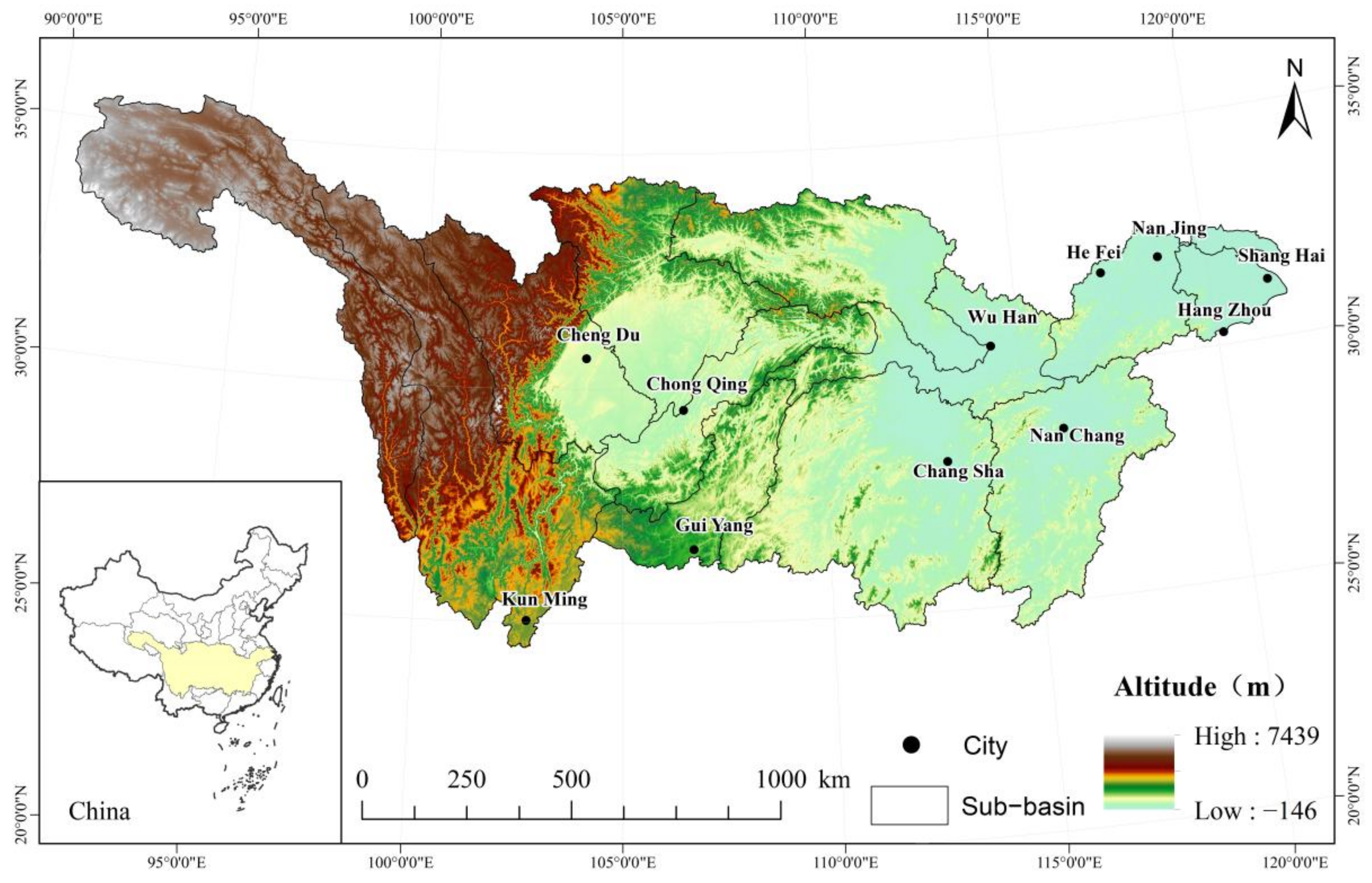
2.1. Study Areas
2.2. Data Used
2.3. Methods
- (1)
- Theil-Sen Median is often apllied to trend analysis for long-term series data [28]. The calculated formula is as follows:
- (2)
- Partial correlation analysis is used to control the linear impact of the third variable while analyzing the correlation between two variables [30]. Before calculating the partial correlation coefficient, the correlation coefficient between the two variables should be calculated first:
- (3)
- Natural and anthropogenic factors affect the change of vegetation cover together. The predicted value of NDVI can be estimated by a regression equation between NDVI, temperature, and precipitation. The residual is obtained by the difference between the actual and predicted values observed by remote sensing [31]. It can reflect the impact of human activities on vegetation cover and is widely used in related studies [32,33,34]:
- (4)
- NDVICC and NDVIHA indicate the changing NDVI trend due to climate and anthropogenic factors. A positive trend rate means that climate or anthropogenic factors promote vegetation cover, while a negative trend rate indicates a reduction in foliage. Based on previous research results [35], the NDVICC and NDVIHA trends were divided into seven levels (Table 1). Using the values shown in Table 2, the contribution rates of climate and anthropogenic factors to vegetation were then estimated and quantified [36,37].
3. Results
3.1. Temporal Variation Characteristics
3.1.1. Basin-Wide Scale
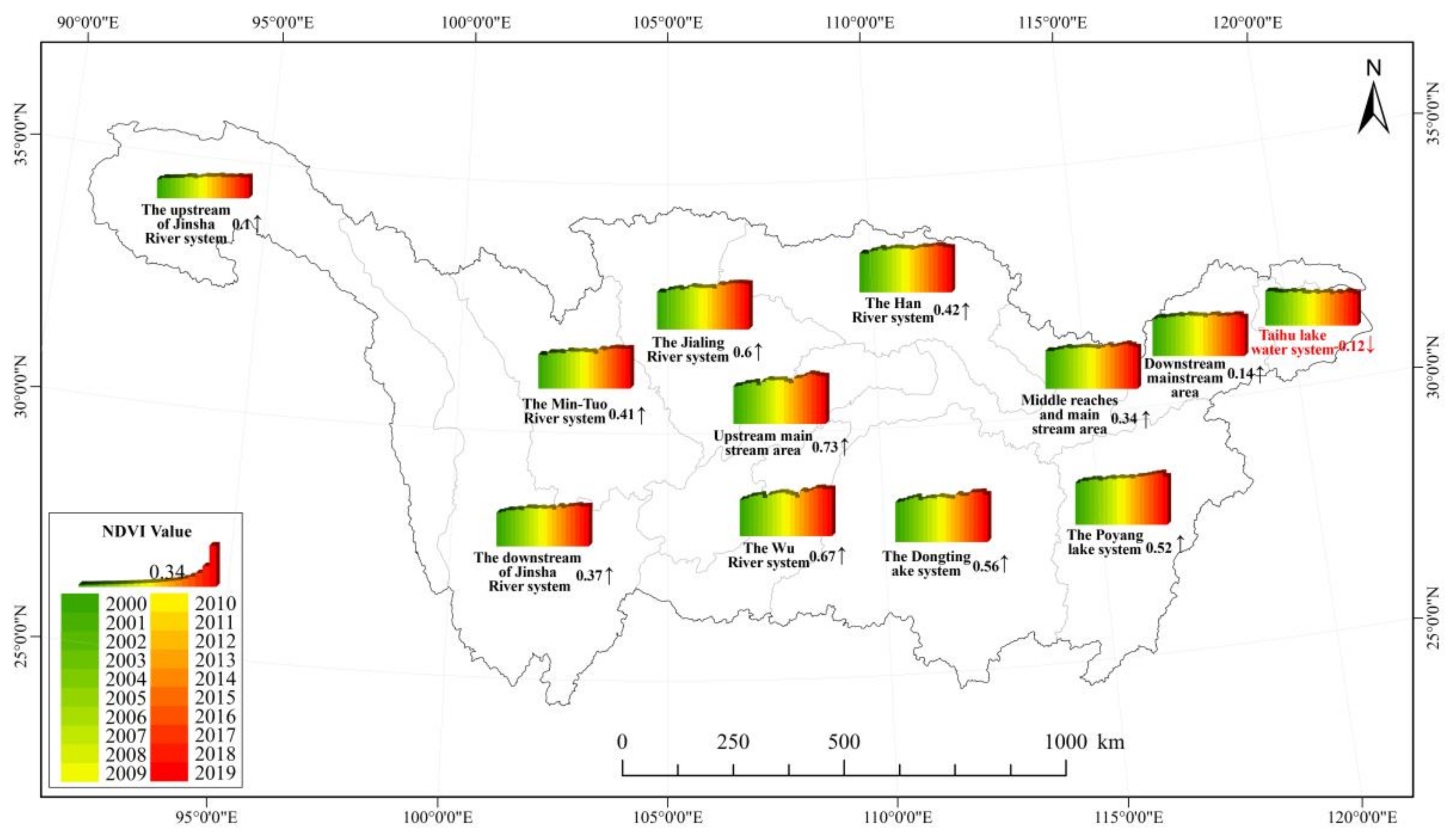
3.1.2. Sub-Basin Scale
3.2. Spatial Variation Characteristics of NDVI
3.2.1. Spatial Distribution Characteristics of NDVI
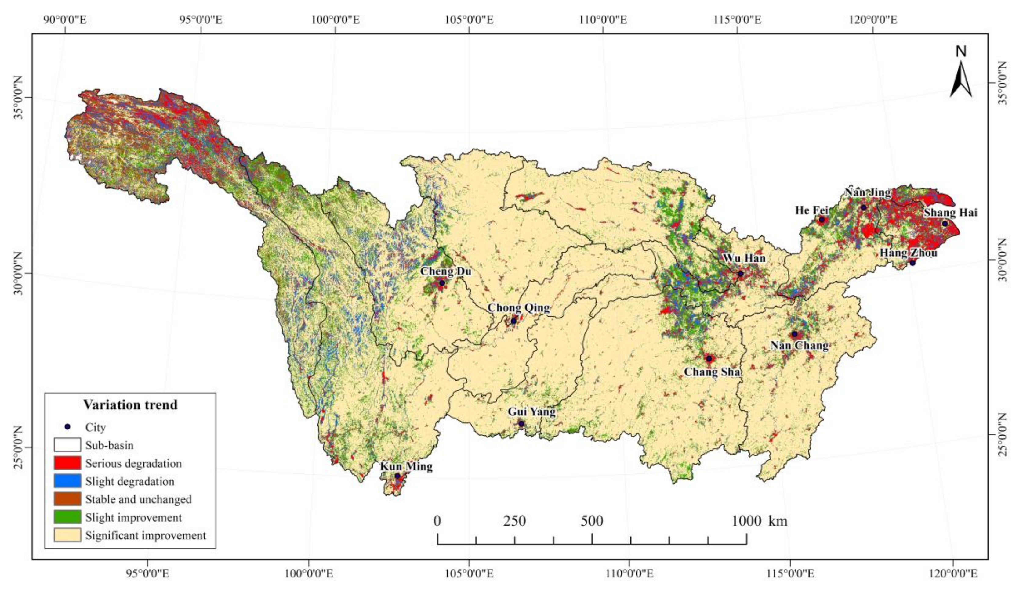
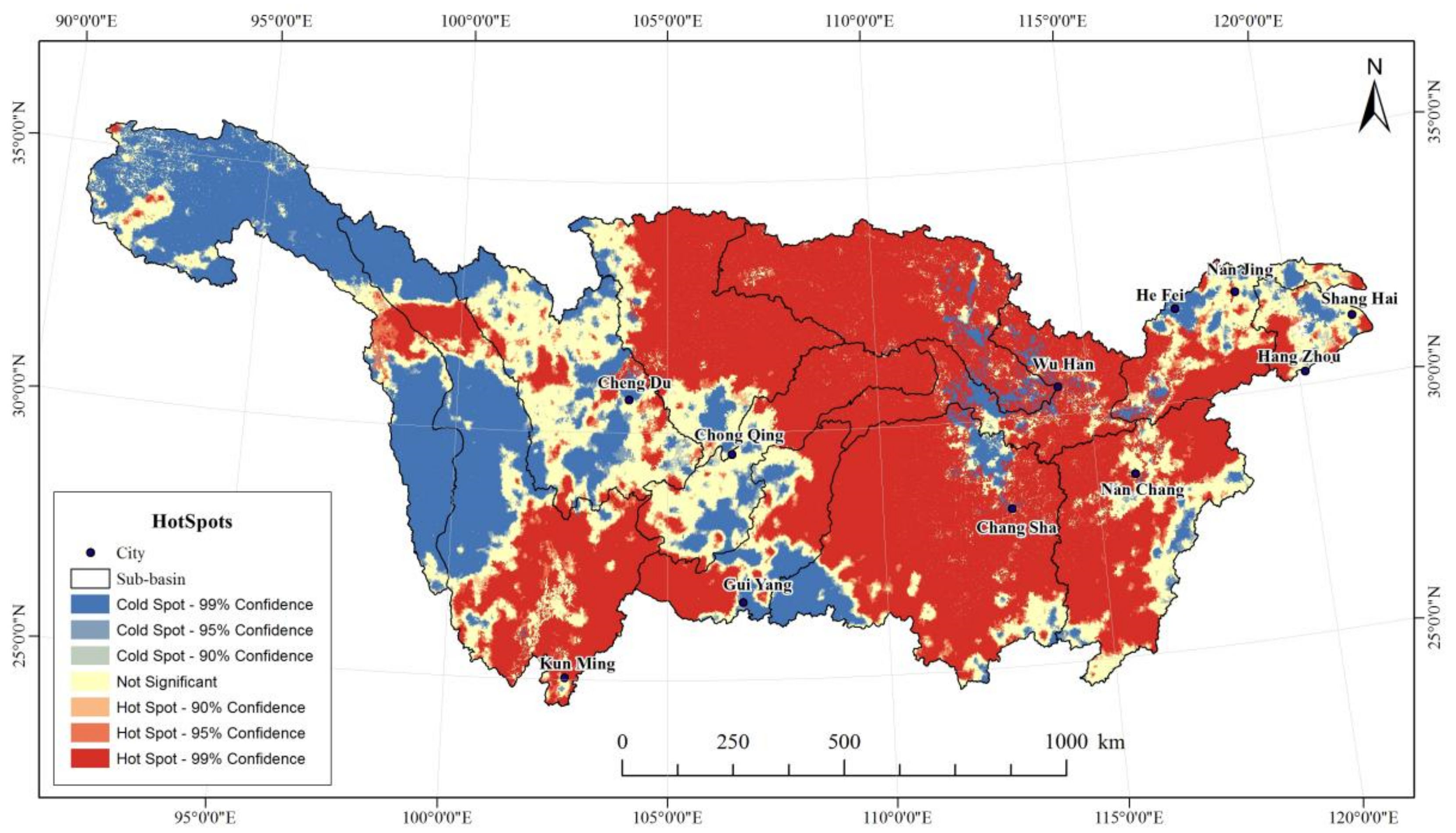
3.2.2. Change Trend Characteristics of NDVI
3.3. Relationship between Climate Change and Vegetation Change
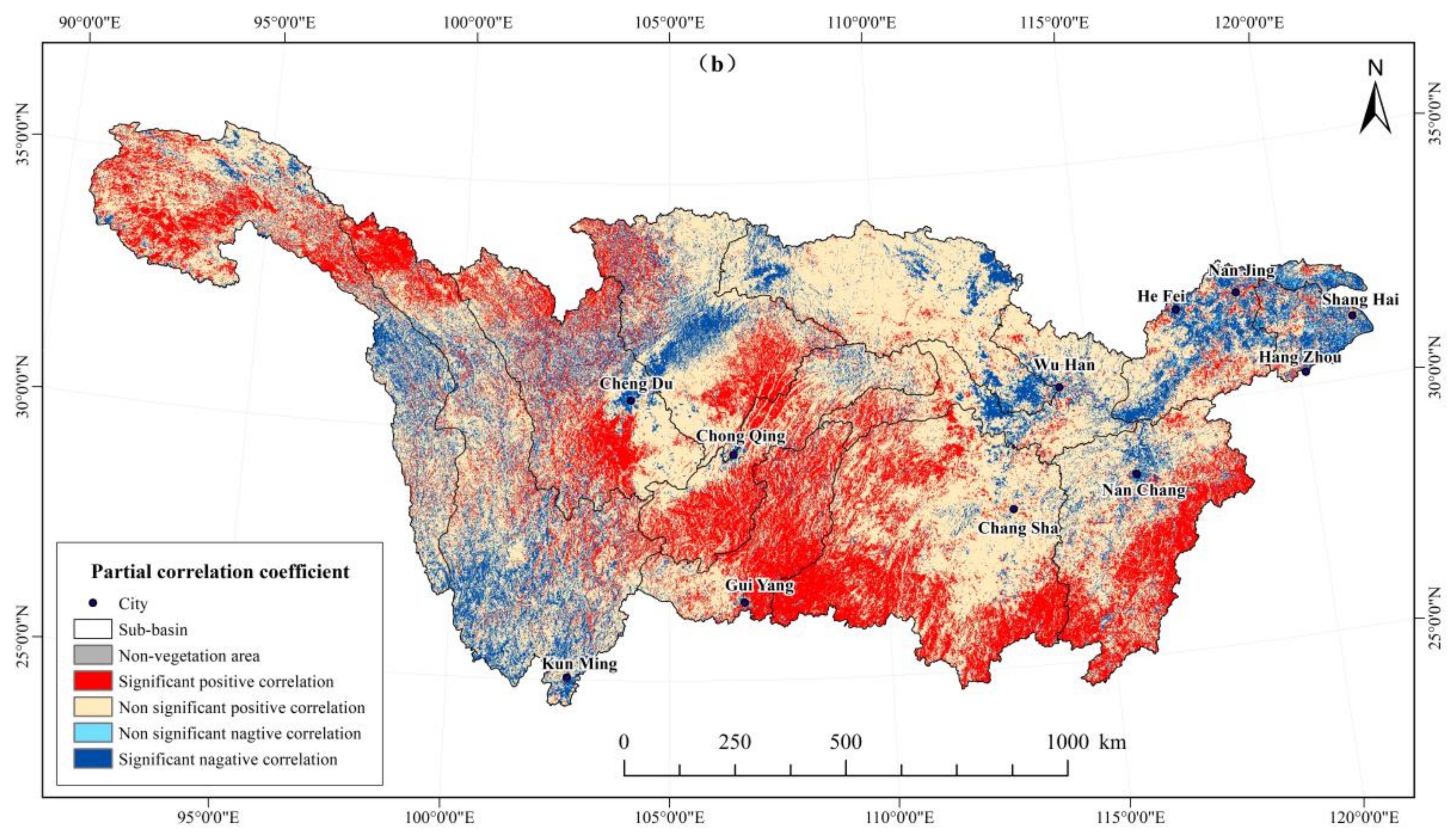
3.4. Relationship between Human Activities and Vegetation Change
3.4.1. Driving Forces of NDVI Changes in the Yangtze River Basin
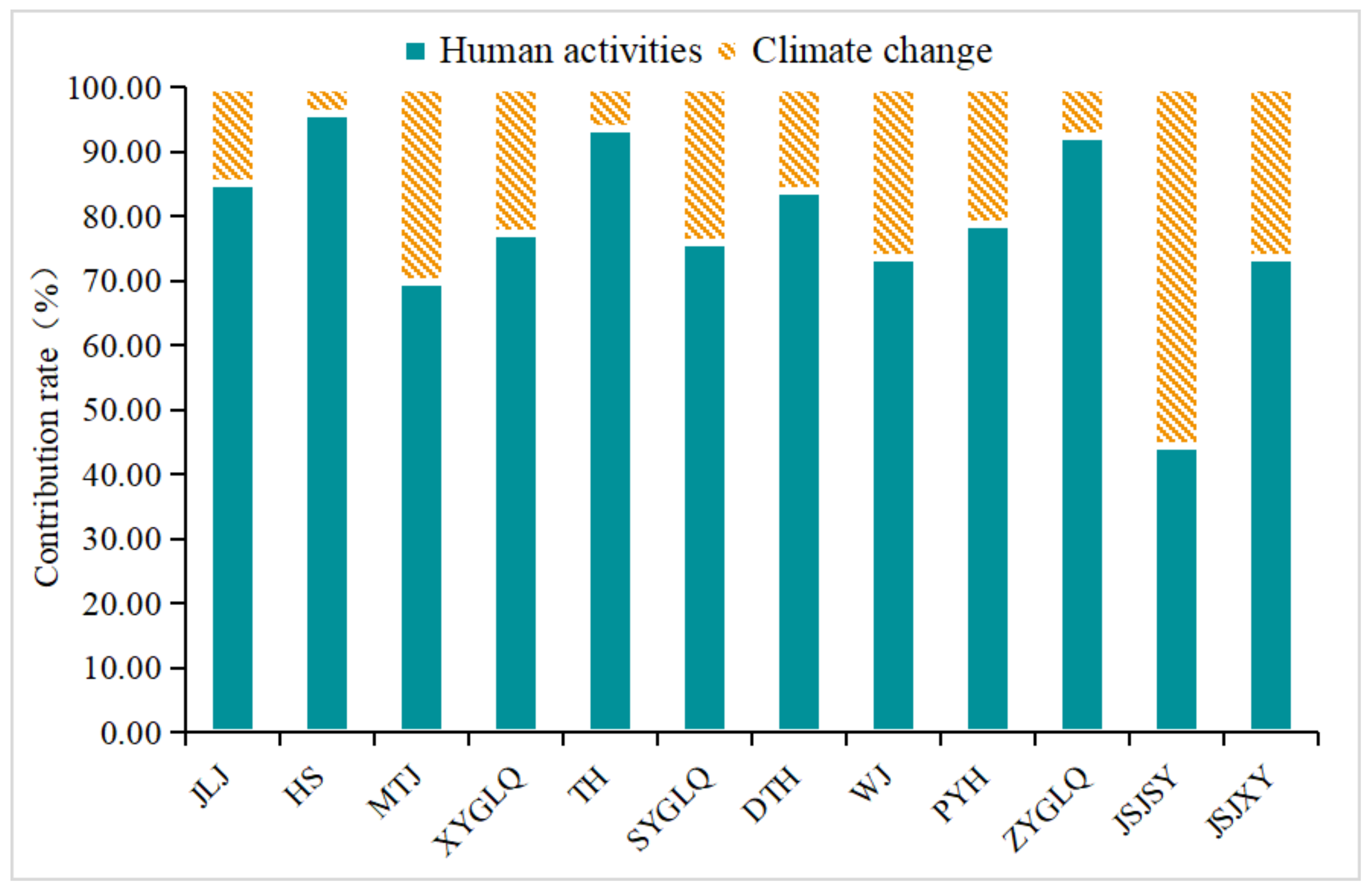
3.4.2. The Relative Contribution of Human Activities and Climate Change to NDVI Change in the Yangtze River Basin
4. Discussion
4.1. NDVI Spatiotemporal Changes
4.2. Influencing Factors of NDVI Change
4.3. Future Research Focus
5. Conclusions
- (1)
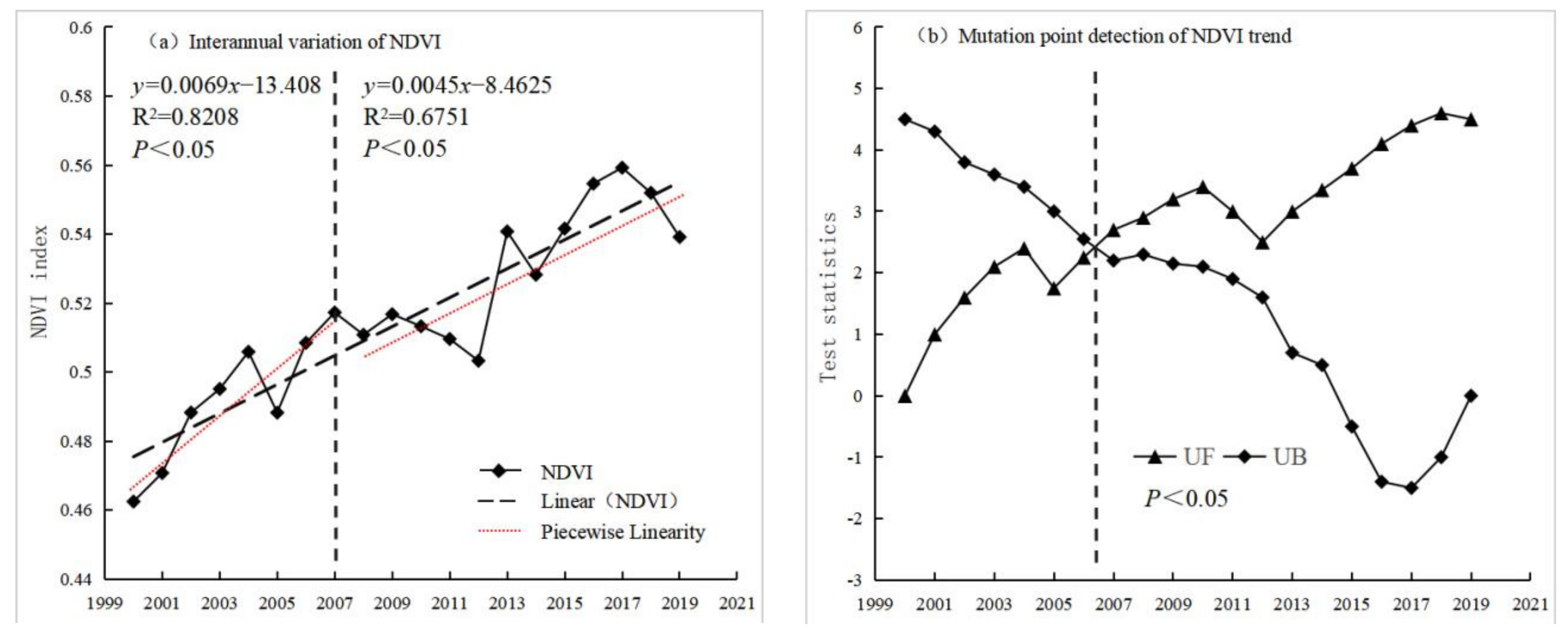
- NDVI of the Yangtze River Basin presents a fluctuating increase trend, the inter-annual growth rate is 0.42%/a (p < 0.01), indicating significant improvements in vegetation cover for the study period. At the sub-basin level, the inter-annual variations in vegetation cover in each sub-basin were significant in the last 20 years. The NDVI in the central sub-basin was significantly higher than that in the eastern and western sub-basins. Except for the Taihu sub-basin, the vegetation cover in the other sub-basins showed an upward trend;
- (2)
- Most areas of the Yangtze River Basin have good vegetation cover, showing a general spatial pattern of “high in the middle and low in the east and west”. The average annual NDVI value was 0.5153. Areas with improved vegetation cover comprised 83.31%, considerably larger than areas with degraded vegetation cover (10.95%). The central region has stronger overall trend of change than the east, and the east is stronger than the west. These findings may be directly related to population density and intensity of anthropogenic activities;
- (3)
- Climatic factors affect the change of vegetation cover in the Yangtze River Basin, and NDVI is positively correlated with temperature and precipitation. The effects of climate factors on vegetation cover changes show pronounced spatial heterogeneity. The promoting effect of temperature on vegetation growth is greater than that of precipitation and is the key factor influencing the interannual variations in vegetation cover;
- (4)
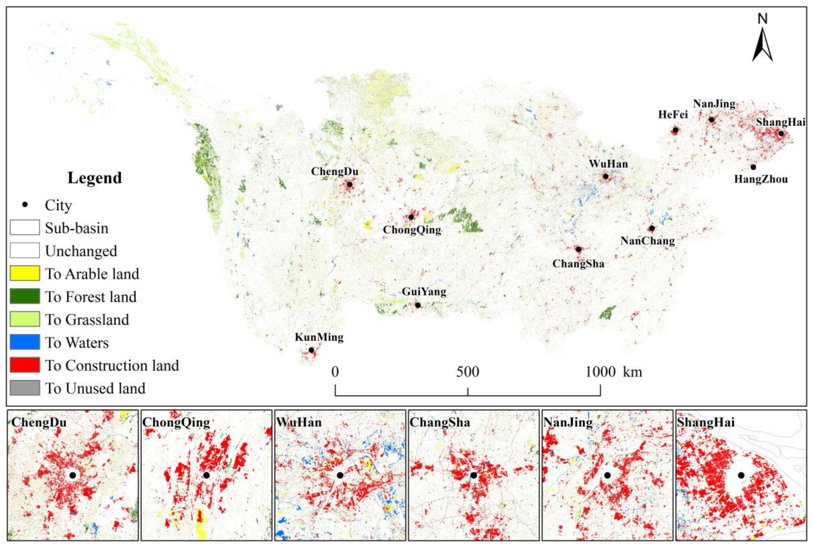
- In terms of affecting factors, anthropogenic and climate factors have jointly promoted NDVI change in the Yangtze River Basin and have exhibited significant spatial differences. Anthropogenic factors such as urban construction, agricultural reclamation, and afforestation are the leading factors of vegetation cover change, contributing 79.29%, while climate change has contributed 20.71%. Human activities were found to have mixed effects on regional vegetation cover changes and were the main influencing factor, particularly in areas where the vegetation changes significantly. In areas where ecological protection projects have been implemented, human activities have a positive impact. In areas around urban agglomerations with higher economic development, anthropogenic factors have an obviously negative effect. The findings suggest that the human activities influence should be highly considered when developing environmental and economic policies and land use strategies in the Yangtze River basin.
Author Contributions
Funding
Institutional Review Board Statement
Informed Consent Statement
Conflicts of Interest
References
- Walker, B.; Steffen, W. The Terrestrial Biosphere and Global Change: Implications for Natural and Managed Ecosystems. A Synthesis of GCTE and Related Research; Cambridge University Press: Cambridge, UK, 1997. [Google Scholar]
- Verbeeck, H.; Kearsley, E. The importance of including lianas in global vegetation models. Proc. Natl. Acad. Sci. USA 2015, 113, E4. [Google Scholar] [CrossRef] [PubMed] [Green Version]
- Ming, C.; Griffis, T.J.; Baker, J.; Wood, J.D.; Ke, X. Simulating crop phenology in the Community Land Model and its impact on energy and carbon fluxes. J. Geophys. Res. Biogeosci. 2015, 120, 310–325. [Google Scholar]
- Liu, Y.; Wang, Q.; Zhang, Z.; Tong, L.; Wang, Z.; Li, J. Grassland dynamics in responses to climate variation and human activities in China from 2000 to 2013. Sci. Total Environ. 2019, 690, 27–39. [Google Scholar] [CrossRef] [PubMed]
- Hansen, M.C.; Potapov, P.V.; Moore, R.; Hancher, M.; Turubanova, S.A.; Tyukavina, A.; Thau, D.; Stehman, S.V.; Goetz, S.J.; Loveland, T.R.; et al. High-Resolution Global Maps of 21st-Century Forest Cover Change. Science 2013, 342, 850–853. [Google Scholar] [CrossRef] [Green Version]
- Chen, T.; Tang, G.; Yuan, Y.; Guo, H.; Chen, X. Unraveling the relative impacts of climate change and human activities on grassland productivity in Central Asia over last three decades. Sci. Total Environ. 2020, 743, 140649. [Google Scholar] [CrossRef]
- Zhang, Y.; Zhu, Z.; Liu, Z.; Zeng, Z.; Ciais, P.; Huang, M.; Liu, Y.; Piao, S. Seasonal and interannual changes in vegetation activity of tropical forests in Southeast Asia. Agric. For. Meteorol. 2016, 224, 1–10. [Google Scholar] [CrossRef]
- Pinzon, J.; Tucker, C. A Non-Stationary 1981–2012 AVHRR NDVI3g time series. Remote Sens. 2014, 6, 6929–6960. [Google Scholar] [CrossRef] [Green Version]
- Abbas, G.; Ahmad, S.; Ahmad, A.; Nasim, W.; Fatima, Z.; Hussain, S.; ur Rehman, M.H.; Khan, M.A.; Hasanuzzaman, M.; Fahad, S.; et al. Quantification the impacts of climate change and crop management on phenology of maize-based cropping system in Punjab, Pakistan. Agric. For. Meteorol. 2017, 247, 42–55. [Google Scholar] [CrossRef]
- Jiao, K.W.; Gao, J.B.; Wu, S.H.; Hou, W.J. Research progress on the response processes of vegetation activity to climate change. Acta Ecol. Sin. 2018, 38, 2229–2238. [Google Scholar]
- Levine, J.M. Ecology: A trail map for trait-based studies. Nature 2016, 529, 163. [Google Scholar] [CrossRef]
- Zhou, L.; Tucker, C.J.; Kaufmann, R.K.; Slayback, D.; Shabanov, N.V.; Myneni, R.B. Variations in northern vegetation activity inferred from satellite data of vegetation index during 1981 to 1999. J. Geophys. Res. Atmos. 2001, 106, 20069–20083. [Google Scholar] [CrossRef]
- Suzuki, R.; Masuda, K.; Dye, D.G. Interannual covariability between actual evapotranspiration and PAL and GIMMS NDVIs of northern Asia. Remote Sens. Environ. 2007, 106, 387–398. [Google Scholar] [CrossRef]
- Mohammat, A.; Wang, X.; Xu, X.; Peng, L.; Piao, S. Drought and spring cooling induced recent decrease in vegetation growth in Inner Asia. Agric. For. Meteorol. 2013, 178–179, 21–30. [Google Scholar] [CrossRef]
- Li, H.X.; Liu, G.H.; Fu, B.J. Response of Vegetation to Climate Change and Human Activity Based on NDVI in the Three-River Headwaters Region. Acta Ecol. Sin. 2011, 31, 5495–5504. [Google Scholar]
- Liu, Z.; Liu, Y.; Li, Y. Anthropogenic contributions dominate trends of vegetation cover change over the farming-pastoral ecotone of northern China. Ecol. Indic. 2018, 95, 370–378. [Google Scholar] [CrossRef]
- Wang, J.; Wang, K.; Zhang, M.; Zhang, C. Impacts of climate change and human activities on vegetation cover in hilly southern China. Ecol. Eng. 2015, 81, 451–461. [Google Scholar] [CrossRef]
- Maeda, E.E.; Pellikka, P.; Siljander, M.; Clark, B. Potential impacts of agricultural expansion and climate change on soil erosion in the Eastern Arc Mountains of Kenya. Geomorphology 2010, 123, 279–289. [Google Scholar] [CrossRef]
- Nunes, A.N.; Almeida, A.; Coelho, C. Impacts of land use and cover type on runoff and soil erosion in a marginal area of Portugal. Appl. Geogr. 2011, 31, 687–699. [Google Scholar] [CrossRef]
- Yang, X.; Zhang, K.; Jia, B.; Ci, L. Desertification assessment in China: An overview. J. Arid Environ. 2005, 63, 517–531. [Google Scholar] [CrossRef]
- Wang, T. Vegetation NDVI Change and Its Relationship with Climate Change and Human Activities in Yulin, Shaanxi Province of China. J. Geosci. Environ. Prot. 2016, 4, 28–40. [Google Scholar] [CrossRef] [Green Version]
- Sun, Y.L.; Shan, M.; Pei, X.R.; Zhang, X.K.; Yang, Y.L. Assessment of the impacts of climate change and human activities on vegetation cover change in the Haihe River basin, China. Phys. Chem. Earth Parts A/B/C 2020, 115, 102834. [Google Scholar] [CrossRef]
- Liu, H.; Huang, Y.F.; Zheng, L. Effects of climate and human activities on vegetation cover changes in Danjiangkou Water Source Areas. Trans. Chin. Soc. Agric. Eng. 2020, 36, 97–105. [Google Scholar]
- Yuan, M.; Zhao, L.; Lin, A.; Li, Q.; She, D.; Qu, S. How do climatic and non-climatic factors contribute to the dynamics of vegetation autumn phenology in the Yellow River Basin, China? Ecol. Indic. 2020, 112, 106112. [Google Scholar] [CrossRef]
- Fang, J.Y.; Song, Y.C.; Liu, H.Y.; Piao, S.L. Vegetation-climate relationship and its application in the division of vegetation zone in China. Acta Bot. Sin. 2002, 44, 1105–1122. [Google Scholar]
- Zhao, A.; Zhang, A.; Liu, X.; Cao, S. Spatiotemporal changes of normalized difference vegetation index (NDVI) and response to climate extremes and ecological restoration in the Loess Plateau, China. Appl. Climatol. 2017, 132, 555–567. [Google Scholar] [CrossRef]
- Yang, G.S.; Xu, X.B.; Li P, X. Research on the construction of green ecological corridors in the Yangtze River Economic Belt. Prog. Geogr. 2015, 34, 1356–1367. [Google Scholar]
- Cao, S.; He, Y.; Zhang, L.; Chen, Y.; Yang, W.; Yao, S.; Sun, Q. Spatiotemporal characteristics of drought and its impact on vegetation in the vegetation region of Northwest China. Ecol. Indic. 2021, 133, 108420. [Google Scholar] [CrossRef]
- Zhao, Z.; Wang, Y.; Zang, Z.; Deng, S.; Lan, T.; Xie, Z.; Xiong, G.; Li, J.; Shen, G. Climate warming has changed phenology and compressed the climatically suitable habitat of Metasequoia glyptostroboides over the last half century. Glob. Ecol. Conserv. 2020, 23, e1140. [Google Scholar] [CrossRef]
- Liu, X.; Zhang, J.; Zhu, X.; Pan, Y.; Liu, Y.; Zhang, D.; Lin, Z. Spatiotemporal changes in vegetation coverage and its driving factors in the Three -River Headwaters Region during 2000–2011. Acta Geogr. Sin. 2014, 24, 288–302. [Google Scholar] [CrossRef]
- Li, A.; Wu, J.; Huang, J. Distinguishing between human-induced and climate-driven vegetation changes: A critical application of RESTREND in inner Mongolia. Landsc. Ecol. 2012, 27, 969–982. [Google Scholar] [CrossRef]
- Evans, J.; Geerken, R. Discrimination between climate and human-induced dryland degradation. J. Arid Environ. 2004, 57, 535–554. [Google Scholar] [CrossRef]
- Geerken, R.; Ilaiwi, M. Assesment of rangeland degradation and development of a stratagy for rehabilitation. Remote Sens. Environ. 2004, 90, 490–504. [Google Scholar] [CrossRef]
- Jiang, L.; Jiapaer, G.; Bao, A.; Guo, H.; Dayisaba, F.N. Vegetation dynamics and responses to climate change and human activities in Central Asia. Sci. Total Environ. 2017, 599–600, 967–980. [Google Scholar] [CrossRef] [PubMed]
- Kai, J.; Fei, W.; Jianqiao, H.; Shangyu, S.H.I.; Wenbin, D.I.N.G. Contribution of climatic change and human activities to vegetation NDVI change over China during 1982–2015. Acta Geogr. Sin. 2020, 75, 05000961. [Google Scholar]
- Wessels, K.J.; Prince, S.D.; Malherbe, J.; Small, J.; Frost, P.E.; Vanzyl, D. Can human-induced land degradation be distinguished from the effects of rainfall variability? A case study in South Africa. J. Arid Environ. 2007, 68, 271–297. [Google Scholar] [CrossRef]
- Sun, W.; Song, X.; Mu, X.; Peng, G.; Zhao, G. Spatiotemporal vegetation cover variations associated with climate change and ecological restoration in the Loess Plateau. Agric. For. Meteorol. 2015, 209–210, 87–99. [Google Scholar] [CrossRef]
- Wan, H.M.; Xia, L.I.; Dong, D.R.; Lin, H.J. Remote Sensing Quantitative Analysis on Vegetation Coverage Change in Lower Reaches of the Tarim River. J. Nat. Resour. 2013, 28, 668–677. [Google Scholar]
- Yuan, L.H.; Jiang, W.G.; Shen, W.M.; Liu, Y.H.; Wang, W.J.; Tao, L.L.; Zheng, H.; Liu, X. The spatio-temporal variations of vegetation cover in the Yellow River Basin from 2000 to 2010. Acta Ecol. Sin. 2013, 33, 7798–7806. [Google Scholar]
- Qu, S.; Wang, L.; Lin, A.; Zhu, H.; Yuan, M. What drives the vegetation restoration in Yangtze River basin, China: Climate change or anthropogenic factors? Ecol. Indic. 2018, 90, 438–450. [Google Scholar] [CrossRef]
- Nemani, R.R. Climate-Driven Increases in Global Terrestrial Net Primary Production from 1982 to 1999. Science 2003, 300, 1560–1563. [Google Scholar] [CrossRef] [Green Version]
- Park, H.; Jeong, S.J.; Ho, C.H.; Kim, J.; Brown, M.E.; Schaepman, M.E. Nonlinear response of vegetation green-up to local temperature variations in temperate and boreal forests in the Northern Hemisphere. Remote Sens. Environ. Interdiscip. J. 2015, 165, 100–108. [Google Scholar] [CrossRef]
- Su, B.; Huang, J.; Zeng, X.; Gao, C.; Jiang, T. Impacts of climate change on streamflow in the upper Yangtze River basin. Clim. Change 2017, 141, 533–546. [Google Scholar] [CrossRef]
- Chi, C.; Park, T.; Wang, X.; Piao, S.; Xu, B.; Chaturvedi, R.K.; Fuchs, R.; Brovkin, V.; Ciais, P.; Fensholt, R. China and India lead in greening of the world through land-use management. Nat. Sustain. 2019, 2, 122–129. [Google Scholar]
- Qu, S.; Wang, L.; Lin, A.; Yu, D.; Yuan, M. Distinguishing the impacts of climate change and anthropogenic factors on vegetation dynamics in the Yangtze River Basin, China. Ecol. Indic. 2020, 108, 105724. [Google Scholar] [CrossRef]
- Piao, S.; Yin, G.; Tan, J.; Cheng, L.; Huang, M.; Li, Y.; Liu, R.; Mao, J.; Myneni, R.B.; Peng, S.; et al. Detection and attribution of vegetation greening trend in China over the last 30years. Glob. Change Biol. 2015, 21, 1601–1609. [Google Scholar] [CrossRef]
- Yu, Z.; Zhang, L.; Rasmus, F.; Wang, K.; Irina, V.; Tian, F. Climate Contributions to Vegetation Variations in Central Asian Drylands: Pre- and Post-USSR Collapse. Remote Sens. 2015, 7, 2449–2470. [Google Scholar]
- Tong, X.; Wang, K.; Yue, Y.; Brandt, M.; Liu, B.; Zhang, C.; Liao, C.; Fensholt, R. Quantifying the effectiveness of ecological restoration projects on long-term vegetation dynamics in the karst regions of Southwest China. Int. J. Appl. Earth Obs. 2017, 54, 105–113. [Google Scholar] [CrossRef] [Green Version]
- Peng, W.F.; Zhang, D.M.; Luo, Y.M.; Tao, S.; Xu, X.L. Geographical Exploration of Natural Factors on NDVI Changes of Sichuan Vegetation. J. Geogr. Sci. 2019, 74, 1758–1776. [Google Scholar]
- Cui, L.F.; Wang, L.C.; Qu, S.; Deng, L.H.; Wang, Z.D. Impacts of temperature, precipitation and human activity on vegetation NDVI in Yangtze River Basin, China. Geogr. Sci. 2020, 45, 1905–1917. [Google Scholar]
- Yao, R.; Wang, L.; Huang, X.; Chen, J.; Li, J.; Niu, Z. Less sensitive of urban surface to climate variability than rural in Northern China. Sci. Total Environ. 2018, 628, 650–660. [Google Scholar] [CrossRef]
- Borzì, I.; Bonaccorso, B. Quantifying Groundwater Resources for Municipal Water Use in a Data-Scarce Region. Hydrology 2021, 8, 184. [Google Scholar] [CrossRef]
- Piao, S.; Wang, X.; Park, T.; Chen, C.; Lian, X.U.; He, Y.; Bjerke, J.W.; Chen, A.; Ciais, P.; Tømmervik, H.; et al. Characteristics, drivers and feedbacks of global greening. Nat. Rev. Earth Environ. 2019, 1, 14–27. [Google Scholar] [CrossRef]
- Zhang, X.; Li, M.; Ma, Z.; Yang, Q.; Lv, M.; Clark, R. Assessment of an evapotranspiration deficit drought index in relation to impacts on ecosystems. Adv. Atmos. Sci. 2019, 36, 1273–1287. [Google Scholar] [CrossRef]
- Liu, X.; Zhu, X.; Pan, Y.; Shuangshuang, L.I.; Yuqi, M.A.; Nie, J. Vegetation dynamics in Qinling-Daba Mountains in relation to climate factors between 2000 and 2014. J. Geogr. Sci. 2016, 26, 45–58. [Google Scholar] [CrossRef] [Green Version]


| Slope (NDVIreal) | Influence Degree |
|---|---|
| <−2.0 | Obvious inhibition |
| −2.0~−1.0 | Moderate inhibition |
| −1.0~−0.2 | Slight inhibition |
| −0.2~0.2 | Uniformity |
| 0.2~1.0 | Slightly promoted |
| 1.0~2.0 | Moderate promotion |
| ≥2.0 | Significantly promoted |
| Slope (NDVIreal) | Driving Factors | Criteria for Dividing the Driving Factors | Contribution Rate of the Driving Factors (%) | ||
|---|---|---|---|---|---|
| Slope (NDVICC) | Slope (NDVIHA) | Climate Change | Human Activities | ||
| >0 | CC & HA | >0 | >0 | ||
| CC | >0 | <0 | 100 | 0 | |
| HA | <0 | <0 | 0 | 100 | |
| <0 | CC & HA | <0 | <0 | ||
| CC | <0 | >0 | 100 | 0 | |
| HA | >0 | <0 | 0 | 100 | |
| Cover | NDVI | Proportion (%) |
|---|---|---|
| Low cover | <0.20 | 5.86% |
| Medium cover | [0.20, 0.40) | 12.20% |
| Medium and high cover | [0.40, 0.60) | 50.10% |
| High cover | ≥0.6 | 31.84% |
| SNDVI | Z Value | Trend of NDVI | Percentage (%) |
|---|---|---|---|
| ≥0.0005 | ≥1.96 | Significantly improvement | 72.64% |
| ≥0.0005 | −1.96–1.96 | Slight improvement | 10.67% |
| −0.0005–0.0005 | −1.96–1.96 | Stable and unchanged | 5.74% |
| ≤−0.0005 | −1.96–1.96 | Slightly degradation | 6.23% |
| ≤−0.0005 | <−1.96 | Serious degradation | 4.72% |
| Significant | Significant Positive Correlation | Non-Significant Positive Correlation | Non-Significant Negative Correlation | Significant Negative Correlation | Non-Vegetation Area |
|---|---|---|---|---|---|
| Precipitation | 6.29% | 52.10% | 3.58% | 37.96% | 0.07% |
| Temperature | 25.45% | 58.91% | 0.56% | 15.01% | 0.07% |
| Impact on Vegetation Change | Pixel Scale (%) | ||||||
|---|---|---|---|---|---|---|---|
| High Inhibition Effect | Moderate Inhibition Effect | Low Inhibition Effect | Uniformity | Low Promotion Effect | Moderate Promotion Effect | High Promotion Effect | |
| Climate change | 0.61% | 1.69% | 8.39% | 22.91% | 33.34% | 18.29% | 14.77% |
| Human activities | 5.51% | 3.36% | 4.68% | 3.01% | 6.71% | 8.87% | 67.87% |
| Contribution Rate (%) | Pixel Scale (%) | ||||||
|---|---|---|---|---|---|---|---|
| <−20% | −20–0% | 0–20% | 20–40% | 40–60% | 60–80% | >80% | |
| Climate change | 4.97% | 10.43% | 44.31% | 23.86% | 10.71% | 2.57% | 3.16% |
| Human activities | 4.97% | 2.27% | 0.89% | 2.57% | 10.71% | 23.86% | 54.74% |
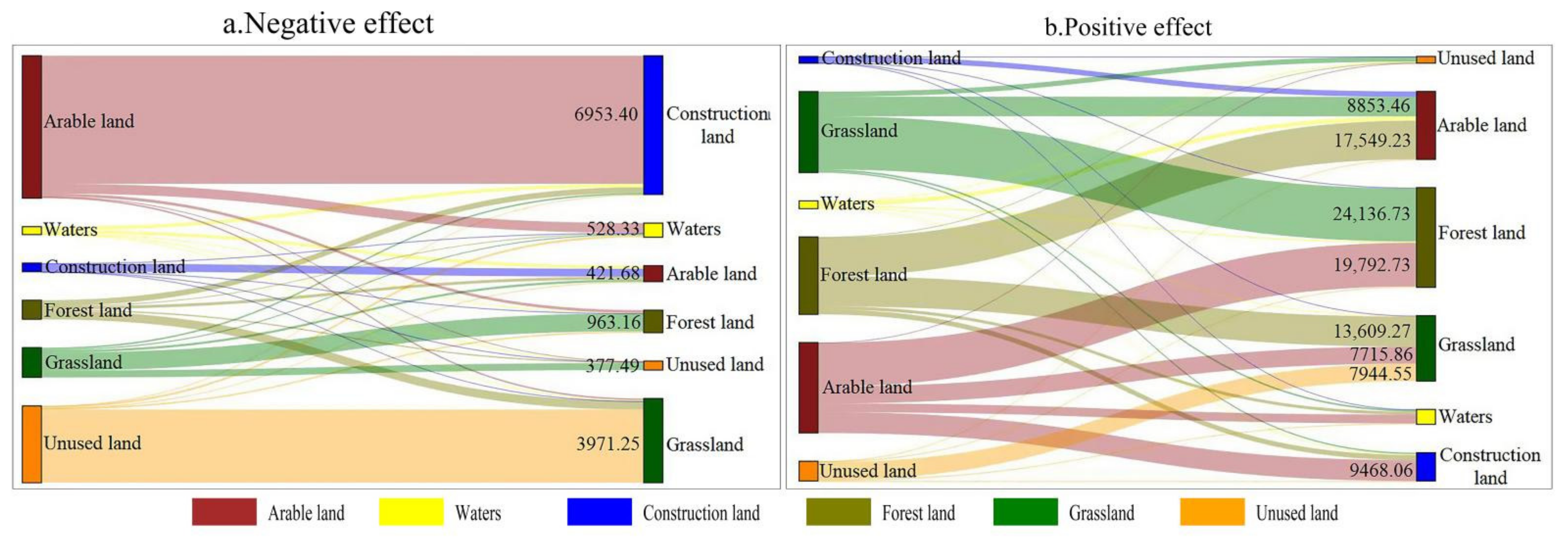
| Land Class in 2000 | Land Class in 2018 | ||||||
|---|---|---|---|---|---|---|---|
| Arable Land | Forest Land | Grassland | Waters | Construction Land | Unused Land | Total | |
| Arable land | 0 | 19,947.43 | 7804.91 | 4481.13 | 16,421.46 | 123.22 | 48,778.15 |
| Forest land | 17,706.62 | 0 | 14,072.08 | 1418.17 | 2609.78 | 357.38 | 36,164.03 |
| Grassland | 8975.65 | 25,099.89 | 0 | 867.2 | 771.99 | 2668.11 | 38,382.84 |
| Waters | 2097.56 | 579.13 | 383.35 | 0 | 579.46 | 337.88 | 3977.38 |
| Construction land | 2867.66 | 328.9 | 137.15 | 214.4 | 0 | 10.13 | 3558.24 |
| Unused land | 59.33 | 542.7 | 11,915.8 | 581.35 | 18.85 | 0 | 13,118.03 |
| Total | 31,706.82 | 46,498.05 | 34,313.29 | 7562.25 | 20,401.54 | 3496.72 | 143,978.67 |
Publisher’s Note: MDPI stays neutral with regard to jurisdictional claims in published maps and institutional affiliations. |
© 2022 by the authors. Licensee MDPI, Basel, Switzerland. This article is an open access article distributed under the terms and conditions of the Creative Commons Attribution (CC BY) license (https://creativecommons.org/licenses/by/4.0/).
Share and Cite
Yi, L.; Sun, Y.; Ouyang, X.; Yin, S. Identifying the Impacts of Climate Change and Human Activities on Vegetation Cover Changes: A Case Study of the Yangtze River Basin, China. Int. J. Environ. Res. Public Health 2022, 19, 6239. https://doi.org/10.3390/ijerph19106239
Yi L, Sun Y, Ouyang X, Yin S. Identifying the Impacts of Climate Change and Human Activities on Vegetation Cover Changes: A Case Study of the Yangtze River Basin, China. International Journal of Environmental Research and Public Health. 2022; 19(10):6239. https://doi.org/10.3390/ijerph19106239
Chicago/Turabian StyleYi, Lang, Ying Sun, Xiao Ouyang, and Shaohua Yin. 2022. "Identifying the Impacts of Climate Change and Human Activities on Vegetation Cover Changes: A Case Study of the Yangtze River Basin, China" International Journal of Environmental Research and Public Health 19, no. 10: 6239. https://doi.org/10.3390/ijerph19106239
APA StyleYi, L., Sun, Y., Ouyang, X., & Yin, S. (2022). Identifying the Impacts of Climate Change and Human Activities on Vegetation Cover Changes: A Case Study of the Yangtze River Basin, China. International Journal of Environmental Research and Public Health, 19(10), 6239. https://doi.org/10.3390/ijerph19106239