Evaluation of Cartosat-1 Multi-Scale Digital Surface Modelling Over France

Abstract
:1. Introduction
2. Results and Discussion
2.1. Influence of GCPs
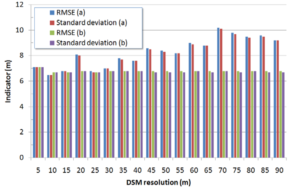
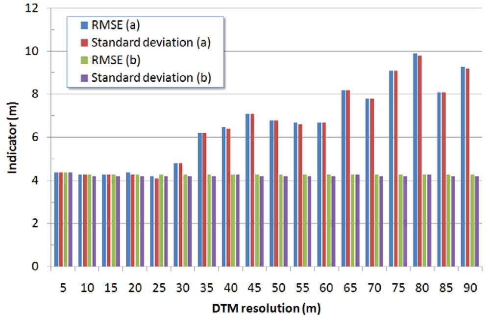
2.2. Influence of ground sampling distance
2.3. Influence of terrain's slope
2.4. Influence of data smoothing
2.5. Comparison of results with other Cartosat-1 investigations on the same test sites
2.6. Results from other Cartosat-1 studies
2.7. Comparison between Cartosat-1 DSMs and DSMs generated using other high resolution satellites
3. Experimental Section
3.1. Theoretical background
- Δh(x,y) is the relative height for the generic image point (x,y);
- Δp(x,y) is the parallax for the generic image point (x,y);
- B/H is the base-to-height ratio;
- H is the height of the sensor above the DSM.
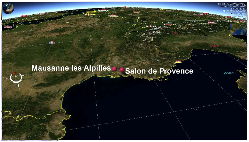
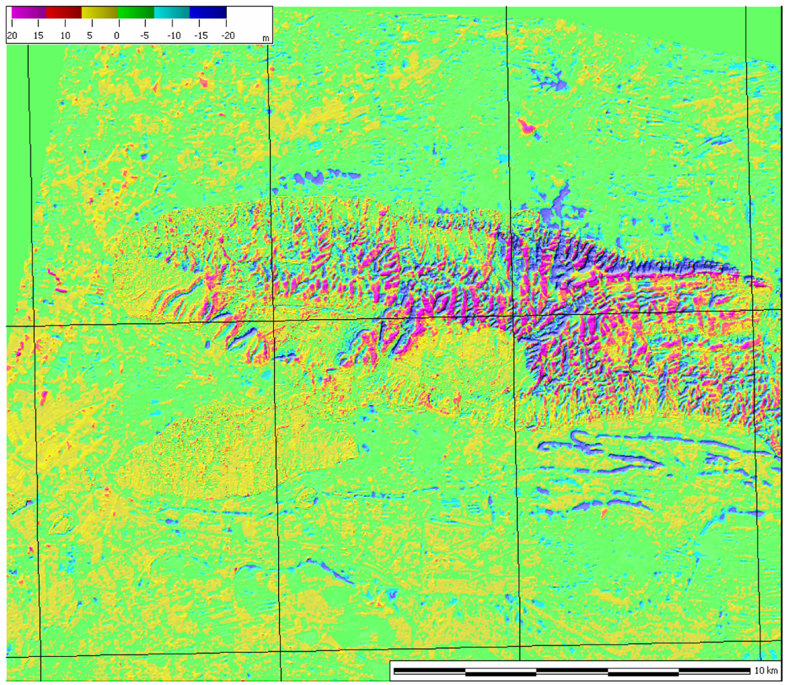
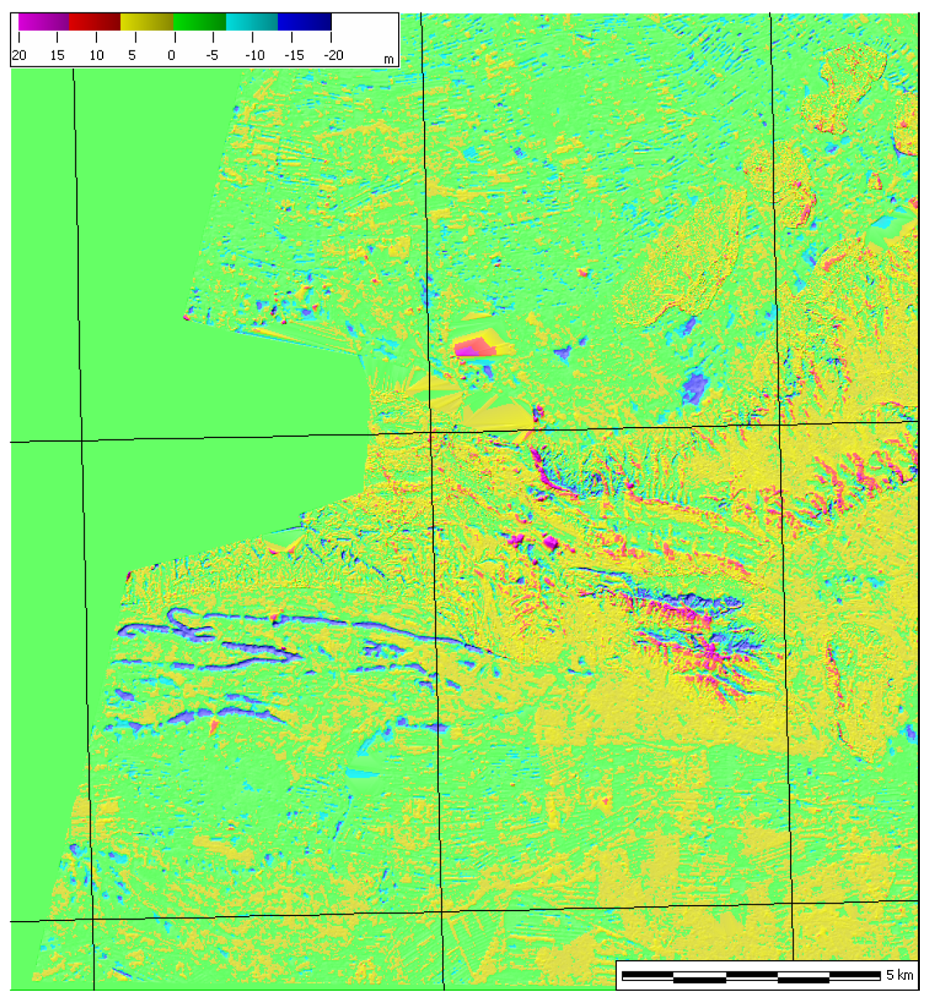
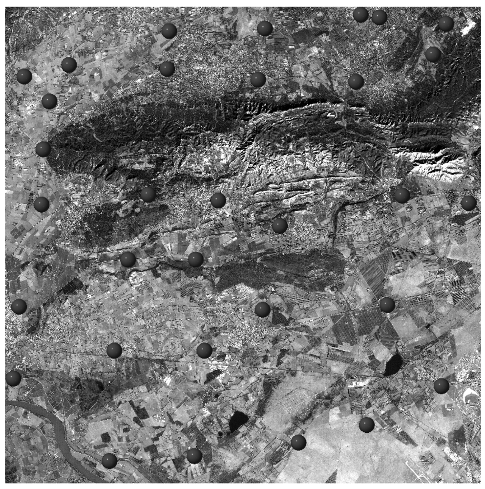
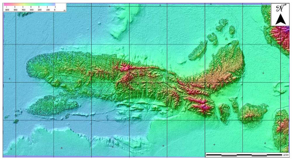
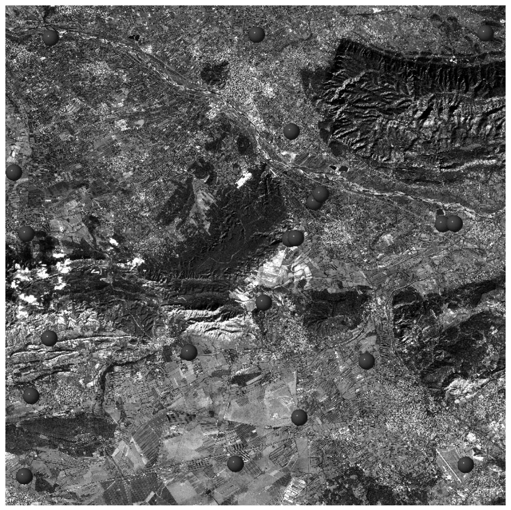
3.2. Study areas and dataset
3.3. Methods
- A set of ICPs extracted from the original C-SAP dataset (ranging from to 23 to 31 for Mausanne les Alpilles and from 13 to 21 for Salon de Provence). The vertical accuracy of reference ICPs was the same of source dataset (0.05 m for Mausanne les Alpilles and better than 2.5 m for Salon de Provence);
- The high-resolution reference DSM resampled to the Cartosat-1 DSM's resolution;
- The medium-resolution reference DTM resampled to the Cartosat-1 DSM's resolution (used for comparison at resolution exceeding 25 m);
4. Conclusions
Acknowledgments
References and Notes
- National Natural Resources Management System (NNRMS). Government of India, NNRMS Secretariat, Indian Space Research Organisation, Department of Space: Bangalore, India, 2004. Available online: http://www.nnrms.gov.in/nnrms/download/NNRMS_Brochure.pdf, accessed June 5, 2008.
- Shubhada, S.; Santhosh, S. India's remote sensing programme. Spaceflight 2006, 48, 308–314. [Google Scholar]
- Radhika, V.N.; Kartikeyan, B.; Gopala Krishna, B.; Chowdhury, S.; Srivastava, P.K. Robust stereo image matching for spaceborne imagery. IEEE Trans. Geosci. Remot. Sen. 2007, 45, 2993–3000. [Google Scholar]
- Metternicht, G.; Hurni, L.; Gogu, R. Remote sensing of landslides: An analysis of the potential contribution to geo-spatial systems for hazard assessment in mountainous environments. Remote Sens. Environ. 2005, 98, 284–303. [Google Scholar]
- Vinod Kumar, K.; Martha, T.R.; Roy, P.S. Mapping damage in the Jammu and Kashmir caused by 8 October 2005 Mw 7.3 earthquake from the Cartosat-1 and Resourcesat-1 imagery. Int. J. Remote Sens. 2006, 27, 4449–4459. [Google Scholar]
- Kamini, J.; Kulkarni, M.; Raghavaswamy, V.; Roy, P.S.; Mishra, P.K. CARTOSAT-1 views the Nalanda Buddhist ruins. Curr. Sci. 2007, 93, 136–138. [Google Scholar]
- Agrawal, R.; Ahmad, N.; Jayaprasad, P.; Mahtab, A.; Vinoth Kumar, J.A.; Pathan, S.K.; Ajai. Comparative evaluation of various algorithms for drainage extraction using Cartosat-1 stereo data. Proceedings of SPIE Agriculture and Hydrology Applications of Remote Sensing, Goa, India, December 5, 2006.
- Bandyopadhyay, S.; Srivastava, S.K.; Jha, M.K.; Hegde, V.S.; Jayaraman, V. Harnessing earth observation (EO) capabilities in hydrogeology: An Indian perspective. Hydrogeol. J. 2007, 15, 155–158. [Google Scholar]
- Pandya, M.R. Estimation of aerosol optical thickness over land using dual angle panchromatic data. Proceedings of SPIE Remote Sensing of the Atmosphere and Clouds, Goa, India, December 8, 2006.
- Martha, T.R.; Kerle, N.; Westen, C.V.; Kumar, K.V. High resolution DEM from Cartosat-1 for landslide investigation in the Himalayan region, India. Geophys. Res. Abstr. 2008, 10. EGU2008-A-03690. [Google Scholar]
- Rao, C.V.; Sathyanarayana, P.; Jain, D.S.; Manjunath, A.S. Topographic map updation using Cartosat-1 data. Proceedings of RSPSoc Annual Conference 2007, Newcastle upon Tyne, UK, September 11-14, 2007.
- DeVencia, K.; Walker, S.; Zhang, B. New approaches to generating and processing high resolution elevation data with imagery. Proceedings of Photogrammetric week 2007, Stuttgart, Germany, 3-7 September 2007; pp. 297–308.
- Gianinetto, M. Multi-scale Digital Terrain Model generation using Cartosat-1 stereo images for the Mausanne les Alpilles test site. ISPRS 2008, 37, 1331–1336. [Google Scholar]
- Gianinetto, M.; Fassi, F. Validation of Cartosat-1 DSM generation for the Salon de Provence test site. ISPRS 2008, 37, 1369–1374. [Google Scholar]
- Kay, S.; Zielinski, R. Orthorectification and geometric quality assessment of Cartosat-1 for common agricultural policy monitoring. ISPRS 2006, 36, 5. [Google Scholar]
- Michalis, P.; Dowman, I. Sensor model evaluation and DEM generation for Cartosat-1. ISPRS 2006, 36, 5. [Google Scholar]
- Gachet, R.; Favé, P. Cartosat-1 DEM extraction capability study over Salon Area. ISPRS XXXVI 2006, 36, 7. [Google Scholar]
- Van Zyla, J.J. The Shuttle Radar Topography Mission (SRTM): a breakthrough in remote sensing of topography. Acta Astron. 2001, 48, 559–565. [Google Scholar]
- National Aeronautics and Space Administration. Digital Elevation Models produced by the SRTM project. Available online: ftp://e0srp01u.ecs.nasa.gov/, accessed June 11, 2008.
- Krishnaswamy, M.; Kalyanaraman, S. Indian remote sensing satellite Cartosat-1: Technical features and data products. GIS Dev. 2002, 1–5. [Google Scholar]
- National Remote Sensing Agency. Cartosat -1 Products. India, 2007. Available online: http://www.nrsa.gov.in/cartosat-1/html/products.html, accessed September 16, 2008.
- Toutin, T. Review article: Geometric processing of remote sensing images: models, algorithms and methods. Int. J. Remote Sens. 2004, 25, 1893–1924. [Google Scholar]
- OpenGIS Consortium. The OpenGIS Abstract Specification. Topic 7: Earth Imagery; OpenGIS Consortium, Inc.: Wayland, MA, USA, October 15 2004; No. 04-107; pp. 1–79. [Google Scholar]
- Dowman, I.; Tao, V. An update on the use of rational functions for photogrammetric restituition. ISPRS Highlights 2002, 7, 26–29. [Google Scholar]
- Gianinetto, M.; Scaioni, M. Automated geometric correction of high-resolution pushbroom satellite data. Photogram. Eng. Remote Sens. 2008, 74, 107–116. [Google Scholar]
- Rodriguez, E.; Morris, C.S.; Belz, J.E. A global assessment of the SRTM performance. Photogram. Eng. Remote Sens. 2006, 72, 249–260. [Google Scholar]
- Toutin, T. ASTER DEMs for geomatic and geoscientific applications: a review. Int. J. Remote Sens. 2008, 29, 1855–1875. [Google Scholar]
- United States Geological Survey (USGS), Center for Earth Resources Observation and Science (EORS): Menlo Park, CA, USA, 2008. Available online: http://edc.usgs.gov/products/elevation/gtopo30/gtopo30.html, accessed June 11, 2008.
- Farr, T.G.; Rosen, P.A.; Caro, E.; Crippen, R.; Duren, R.; Hensley, S.; Kobrick, M.; Paller, M.; Rodriguez, E.; Roth, L.; Seal, D.; Shaffer, S.; Shimada, J.; Umland, J.; Werner, M.; Oskin, M.; Burbank, D.; Alsdorf, D. The shuttle radar topography mission. Rev. Geophys. 2007, 45, RG2004. [Google Scholar]
- Lang, H.R. ATBD-AST-08 Algorithm theoretical basis document for ASTER digital elevation models, version 3.0; Jet Propulsion Laboratory-NASA: California, CA, USA, 1999. [Google Scholar]
- Cuartero, A.; Felicísimo, A.M.; Ariza, F.J. Accuracy, reliability, and depuration of SPOT HRV and terra ASTER digital elevation models. IEEE Trans. Geosci. Remote Sens. 2005, 43, 404–407. [Google Scholar]
- Gianinetto, M. Automatic digital terrain model generation using Cartosat-1 stereo images. Sens. Rev. 2008, 28, 299–310. [Google Scholar]
- Reulke, R.; Gimel'farb, G.; Becker, S. Iterative stereo reconstruction from CCD-line scanner images, CAIP 2005; Gagalowicz, A., Philips, W., Eds.; Springer-Verlag: New York, NY, USA, 2005; pp. 112–119. [Google Scholar]
- Förstner, W. A feature based correspondence algorithm for image matching. ISPRS 1985, 26, 150–166. [Google Scholar]
- Kraus, K. Photogrammetry; Dümmler Verlag: Bonn, Germany, 1997. [Google Scholar]
- Papakostas, G.A.; Boutalis, Y.S.; Karras, D.A.; Mertzios, B.G. A new class of Zernike moments for computer vision applications. Inf. Sci. 2007, 177, 2802–2819. [Google Scholar]
- Höhle, J.; Potucková, M. Automated quality control for orthoimages and DEMs. Photogram. Eng. Remote Sens. 2005, 71, 81–87. [Google Scholar]
- Rao, D.P. Geographic data needed in the interpretation of Indian satellite-based remote sensing data: Opportunities and realities. Curr. Sci. 2000, 79, 468–473. [Google Scholar]
- Krishna Murthy, Y.V.N.; Srinivasa Rao, S.; Prakasa Rao, D.S.; Jayaraman, V. Analysis of DEM generated using Cartosat-1 stereo data over Mausanne les Alpilles – Cartosat scientific appraisal programme (CSAP TS-5). ISPRS 2008, 37, 1343–1348. [Google Scholar]
- Nandakumar, R.; Amitab Chamy, M.P.T.; Sekhar Kopparthi, S.S.; Paswan, G.; Prakash, S.; Singh, S. Synthesis of investigations under ISPRS-ISRO Cartosat-1 Scientific Assessment Programme primarily for DSM generation. ISPRS 2008, 37, 1279–1286. [Google Scholar]
- Lehner, M.; D'Angelo, P.; Müller, R.; Reinartz, P. Stereo evaluation of Cartosat-1 data summary of DLR results during Cartosat-1 scientific assessment program. ISPRS 2008, 37, 1295–1300. [Google Scholar]
- Crespi, M.G.; Barbato, F.; De Vendictis, L.; Volpe, F.; Onori, R.; Poli, D.; Wang, X. Orientation, orthorectification, terrain and city modeling from Cartosat-1 stereo imagery: Preliminary results in the first phase of ISPRS-ISRO C-SAP. J. Appl. Remote Sens. 2008, 2, 023523. [Google Scholar]
- Sadasiva Rao, B.; Murali Mohan, A.S.R.K.V.; Kalyanaraman, K.; Radhakrishnan, K. Evaluation of Cartosat-1 stereo data of Rome. ISPRS 2006, 36, 5. [Google Scholar]
- Poon, J.; Fraser, C.S.; Chunsun, Z.; Li, Z.; Gruen, A. Quality assessment of digital surface models generated from IKONOS imagery. Photogram Rec. 2005, 20, 162–171. [Google Scholar]
- Zhang, L.; Gruen, A. Multi-image matching for DSM generation from IKONOS imagery. ISPRS J. Photogramm. Remote Sens. 2006, 60, 195–211. [Google Scholar]
- Baltsavias, E.; Kocaman, S.; Wolff, K. Analysis of Cartosat-1 images regarding image quality, 3D point measurement and DSM generation. Photogram. Rec. 2008, 23, 305–322. [Google Scholar]
- Srivastava, P.K.; Srinivasan, T.P.; Gupta, A.; Singh, S.; Nain, J.S.; Amitabh; Prakash, S.; Kartikeyan, B.; Gopala Krishna, B. Advanced studies in strip pair processing of Cartosat-1 data. Photogramm. Rec. 2008, 23, 290–304. [Google Scholar]
- Titarov, P.S. Evaluation of Cartosat 1 geometric potential. ISPRS 2008, 37, 841–846. [Google Scholar]
- Lehner, M.; d'Angelo, P.; Müller, M.; Reinartz, P. Stereo evaluation of Cartosat-1 data summary of DLR results during Cartosat-1 scientific assessment program. ISPRS 2008, 37, 1295–1300. [Google Scholar]
- Michalis, P.; Dowman, I. Exterior orientation improved by the coplanarity equation and DEM generation for Cartosat-1. ISPRS 2008, 37, 1301–1308. [Google Scholar]
- Hu, Y.; Croitoru, A.; Tao, V. Understanding the rational function model: methods and applications. ISPRS 2004, 35, 119–124. [Google Scholar]
- Mitasova, H.; Mitas, L.; Harmon, R.S. Simultaneous spline approximation and topographic analysis for lidar elevation data in Open-Source GIS. IEEE Geosci. Remote Sens. Lett. 2005, 2, 375–379. [Google Scholar]
- Sauerbier, M. Accuracy of automated aerotriangulation and DTM generation for low textured images. ISPRS 2004, 35, 521–526. [Google Scholar]
- Milledge, D.G.; Lane, S.N.; Warburton, J. The potential of digital filtering of generic topographic data for geomorphological research. Earth Surf. Process. Landforms 2009, 34, 63–74. [Google Scholar]


| Resolution (m) | LE90 (m) vs. slope (a) | LE90 (m) vs. slope (b) | ||||
|---|---|---|---|---|---|---|
| < 20% | 20% – 40% | > 40% | < 20% | 20% – 40% | > 40% | |
| 5 | 5.6 | 14.3 | 20.1 | 5.6 | 14.3 | 20.1 |
| 10 | 5.2 | 13.7 | 22.4 | 5.6 | 13.8 | 23.3 |
| 15 | 5.8 | 14.3 | 20.3 | 5.6 | 14.4 | 20.4 |
| 20 | 5.6 | 20.6 | 26.2 | 5.7 | 15.5 | 21.1 |
| 25 | 4.9 | 15.3 | 20.0 | 5.6 | 14.3 | 19.9 |
| 30 | 5.2 | 17.7 | 22.3 | 5.8 | 15.6 | 21.1 |
| 35 | 5.3 | 19.3 | 24.2 | 5.6 | 14.5 | 20.1 |
| 40 | 5.6 | 19.6 | 23.9 | 5.7 | 15.4 | 20.9 |
| 45 | 6.0 | 21.4 | 26.4 | 5.6 | 14.2 | 20.0 |
| 50 | 6.4 | 21.1 | 25.8 | 5.7 | 15.5 | 21.0 |
| 55 | 5.9 | 20.5 | 25.1 | 5.5 | 13.9 | 20.1 |
| 60 | 7.2 | 23.3 | 27.8 | 5.8 | 15.5 | 21.4 |
| 65 | 6.6 | 22.5 | 26.3 | 5.5 | 14.1 | 20.2 |
| 70 | 8.7 | 25.8 | 30.7 | 5.7 | 15.5 | 21.2 |
| 75 | 7.8 | 24.4 | 28.7 | 5.6 | 14.2 | 20.2 |
| 80 | 8.0 | 25.5 | 28.7 | 5.7 | 15.5 | 20.9 |
| 85 | 7.6 | 24.3 | 28.1 | 5.5 | 14.5 | 19.8 |
| 90 | 7.6 | 24.6 | 28.1 | 5.8 | 15.8 | 21.1 |
| Resolution (m) | LE90 (m) vs. slope (a) | LE90 (m) vs. slope (b) | ||||
|---|---|---|---|---|---|---|
| < 20% | 20% – 40% | >40% | < 20% | 20% – 40% | > 40% | |
| 5 | 5.3 | 6.8 | 9.2 | 5.3 | 6.8 | 9.2 |
| 10 | 5.0 | 8.2 | 11.5 | 5.2 | 7.4 | 10.4 |
| 15 | 5.8 | 7.0 | 9.8 | 5.2 | 7.3 | 10.1 |
| 20 | 4.7 | 9.8 | 12.4 | 5.2 | 7.4 | 10.3 |
| 25 | 5.0 | 14.0 | 23.0 | 5.1 | 7.4 | 10.1 |
| 30 | 4.8 | 12.1 | 14.7 | 5.2 | 7.4 | 10.6 |
| 35 | 5.1 | 15.1 | 20.1 | 5.2 | 7.3 | 10.1 |
| 40 | 5.5 | 16.5 | 21.2 | 5.2 | 7.5 | 11.2 |
| 45 | 5.6 | 17.3 | 23.0 | 5.2 | 7.3 | 10.0 |
| 50 | 5.4 | 17.6 | 22.6 | 5.2 | 7.4 | 10.4 |
| 55 | 5.3 | 16.7 | 21.3 | 5.2 | 7.3 | 10.0 |
| 60 | 5.5 | 18.2 | 21.3 | 5.2 | 7.6 | 10.8 |
| 65 | 6.5 | 20.6 | 26.4 | 5.2 | 7.4 | 9.9 |
| 70 | 6.2 | 20.1 | 25.7 | 5.2 | 7.4 | 10.3 |
| 75 | 7.0 | 22.7 | 30.0 | 5.2 | 7.3 | 9.8 |
| 80 | 8.4 | 25.5 | 32.3 | 5.2 | 7.3 | 10.8 |
| 85 | 5.8 | 20.4 | 25.2 | 5.2 | 7.3 | 9.8 |
| 90 | 8.1 | 24.6 | 31.0 | 5.2 | 7.7 | 10.7 |
© 2009 by the authors; licensee Molecular Diversity Preservation International, Basel, Switzerland. This article is an open access article distributed under the terms and conditions of the Creative Commons Attribution license (http://creativecommons.org/licenses/by/3.0/).
Share and Cite
Gianinetto, M. Evaluation of Cartosat-1 Multi-Scale Digital Surface Modelling Over France. Sensors 2009, 9, 3269-3288. https://doi.org/10.3390/s90503269
Gianinetto M. Evaluation of Cartosat-1 Multi-Scale Digital Surface Modelling Over France. Sensors. 2009; 9(5):3269-3288. https://doi.org/10.3390/s90503269
Chicago/Turabian StyleGianinetto, Marco. 2009. "Evaluation of Cartosat-1 Multi-Scale Digital Surface Modelling Over France" Sensors 9, no. 5: 3269-3288. https://doi.org/10.3390/s90503269
APA StyleGianinetto, M. (2009). Evaluation of Cartosat-1 Multi-Scale Digital Surface Modelling Over France. Sensors, 9(5), 3269-3288. https://doi.org/10.3390/s90503269