Connecting Hazard Analysts and Risk Managers to Sensor Information


Abstract
:1. Introduction
2. International framework
3. GeoHazData concept
User requirements
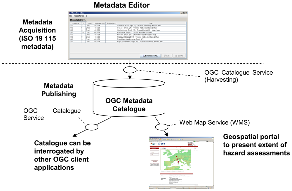
GeoHazData Architecture
Catalogue content
- Fundamental data: pertaining to the characteristics of the map itself (e.g. coverage, scale, date of production, creator and publishing organisation). These are “standard” data fields that are relevant to many geospatial datasets and are already provided for in geospatial metadata standards.
- Information providing an indication of the quality of the map including how and why this map was generated and the data and methods used.
- The sources: the user requirements process defined a set of “interpreted data layers” for each of the geohazards that are typically required for evaluating hazard. These interpreted data layers are listed in Table 1. For each of these interpreted data layers a certain number of measured data layers have been identified.
- The process: that allowed the production of the hazard maps. The process is often a clearly defined process, such as modelling tools used to map the hazard complemented by advice from geologists.
- Legal constraints on access and use applied to the hazard map itself or of the underlying data.
Interoperability features
Lessons learnt and conclusion
Acknowledgments
References and Notes
- Vecchia, V. A unified approach to probabilistic risk assessments for earthquakes, floods, landslides, and volcanoes. Proceedings of a multidiscipilinary workshop held in Golden, Colorado, November 16–17 1999; Open-File Report 01-324. 2001. [Google Scholar]
- Douglas, J. Methods and tools for risk evaluation, RISK-NAT; Module 4. Progress report. RP-54041-FR; BRGM: Orléans, France, 2005. [Google Scholar]
- Thierry, P.; Stieltjes, L.; Kouokam, E.; Nguéya, P.; Salley, P.M. Multi-hazard risk mapping and assessment on an active volcano: the GRINP project at Mount Cameroon. Natural Hazards 2008, 45, 429–456. [Google Scholar] [CrossRef]
- Hosford, S.; Le Cozannet, G. IGOS Geohazards Mid-Term Report; BRGM/RP-54827-FR; 2006. [Google Scholar]
- Le Cozannet, G.; Hosford, S.; Coraboeuf, D.; Salichon, J. Metadata Editor User Guide; Final Report, BRGM/RP-54937-FR; 2006. [Google Scholar]

| Seismic hazard | Ground instability hazard | Volcanic hazards |
|---|---|---|
| Instrumental seismicity catalogue | Geological characterisation | Volcanological structure |
| Amplification spectrum | Geotechnical characterisation | Geological characterisation |
| Crustal deformation in region | Hydrogeological characterisation | Geomorphological characterisation |
| Active fault catalogue | Geomorphological characterisation | |
| Model of crustal velocity structure | Topographic surface | Geotechnical characterisation |
| A posteriori liquefaction occurrence during earthquake | Deformation monitoring | Hydrogeological characterisation |
| Gas information | ||
| Liquefaction susceptibility | Historical events database | |
| Earthquake forecast maps | Deformation monitoring | |
| Digital elevation model (site effects) | Geochemical monitoring | |
| Seismic monitoring | ||
© 2008 by the authors; licensee Molecular Diversity Preservation International, Basel, Switzerland. This article is an open-access article distributed under the terms and conditions of the Creative Commons Attribution license ( http://creativecommons.org/licenses/by/3.0/).
Share and Cite
Le Cozannet, G.; Hosford, S.; Douglas, J.; Serrano, J.-J.; Coraboeuf, D.; Comte, J. Connecting Hazard Analysts and Risk Managers to Sensor Information. Sensors 2008, 8, 3932-3937. https://doi.org/10.3390/s8063932
Le Cozannet G, Hosford S, Douglas J, Serrano J-J, Coraboeuf D, Comte J. Connecting Hazard Analysts and Risk Managers to Sensor Information. Sensors. 2008; 8(6):3932-3937. https://doi.org/10.3390/s8063932
Chicago/Turabian StyleLe Cozannet, Gonéri, Steven Hosford, John Douglas, Jean-Jacques Serrano, Damien Coraboeuf, and Jérémie Comte. 2008. "Connecting Hazard Analysts and Risk Managers to Sensor Information" Sensors 8, no. 6: 3932-3937. https://doi.org/10.3390/s8063932
APA StyleLe Cozannet, G., Hosford, S., Douglas, J., Serrano, J.-J., Coraboeuf, D., & Comte, J. (2008). Connecting Hazard Analysts and Risk Managers to Sensor Information. Sensors, 8(6), 3932-3937. https://doi.org/10.3390/s8063932