
Investigating Hydroclimatic Variables Trends on the Natural Lakes of Western Greece Using Earth Observation Data


Abstract
1. Introduction
2. Materials and Methods
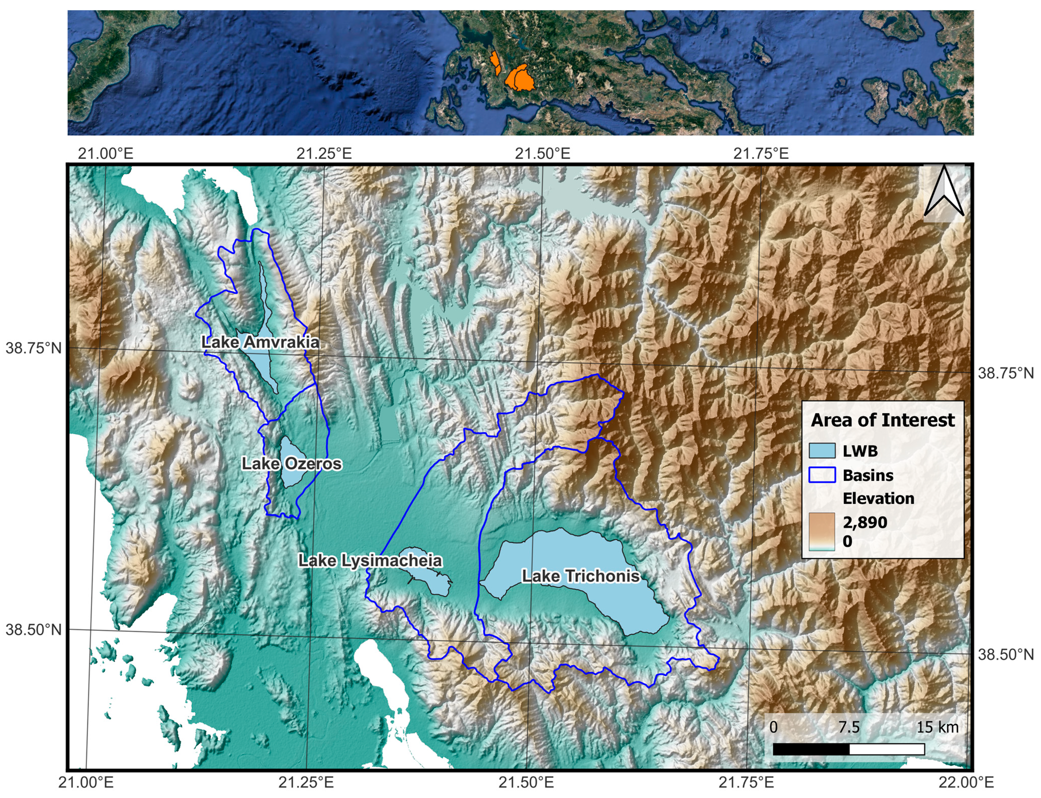
2.1. Study Area
2.2. Data Used
2.2.1. Landsat Family IMAGERY
2.2.2. In-Situ Precipitation Measurements
2.2.3. ERA5-Land Monthly Temperature Data
2.2.4. CORINE Land Cover (CLC)
2.3. Methodology
2.3.1. Water Area Extraction
2.3.2. Statistical Point of Change and Trend Analysis
3. Results
3.1. Water Area Timeseries and Trends
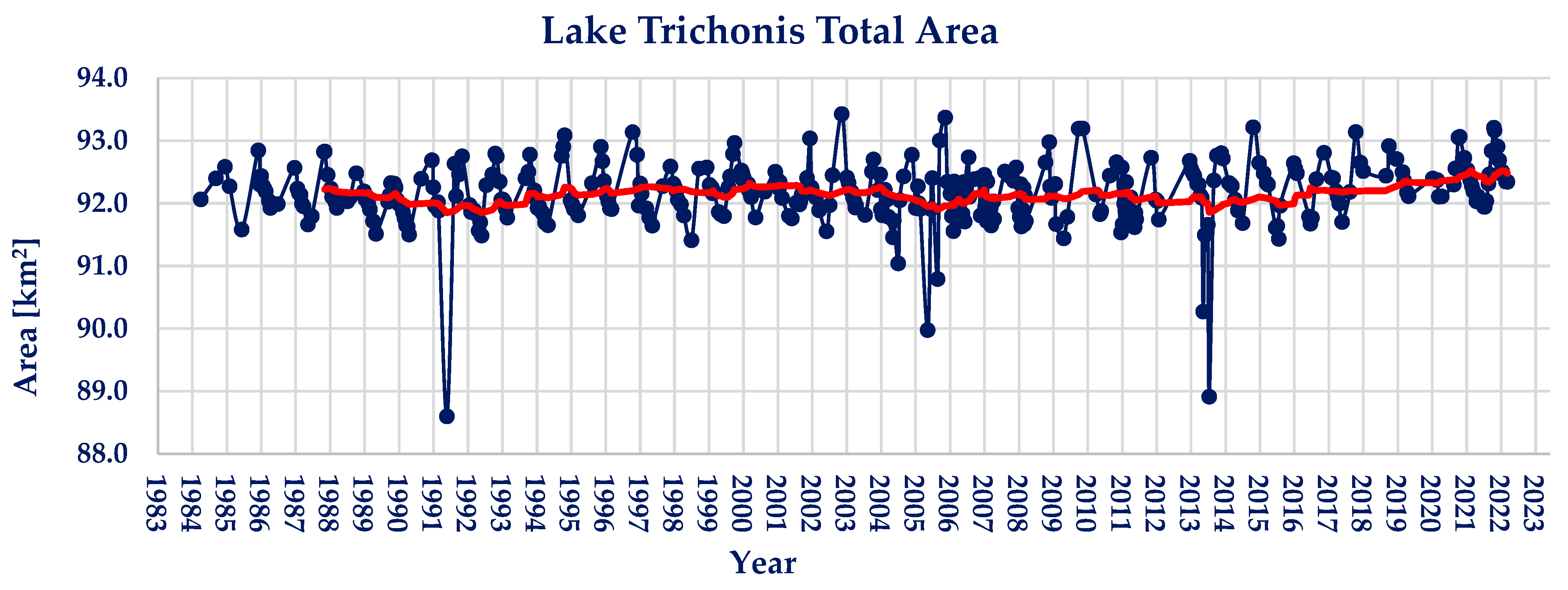
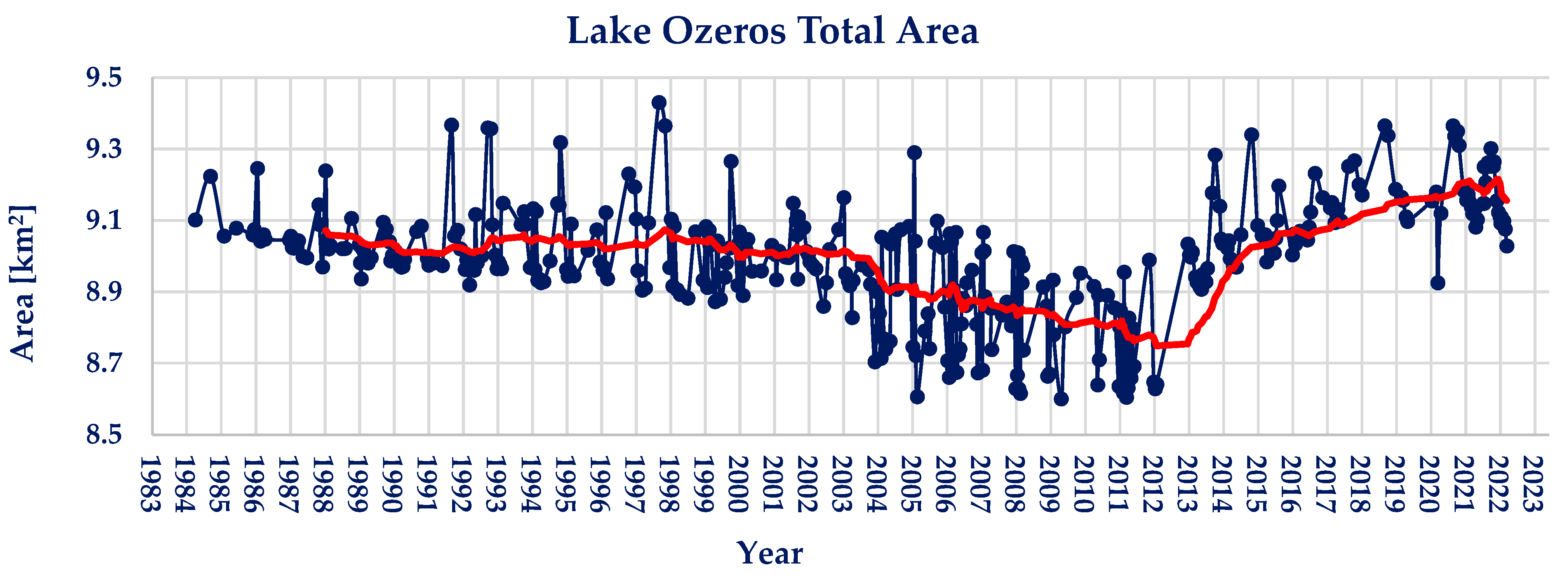
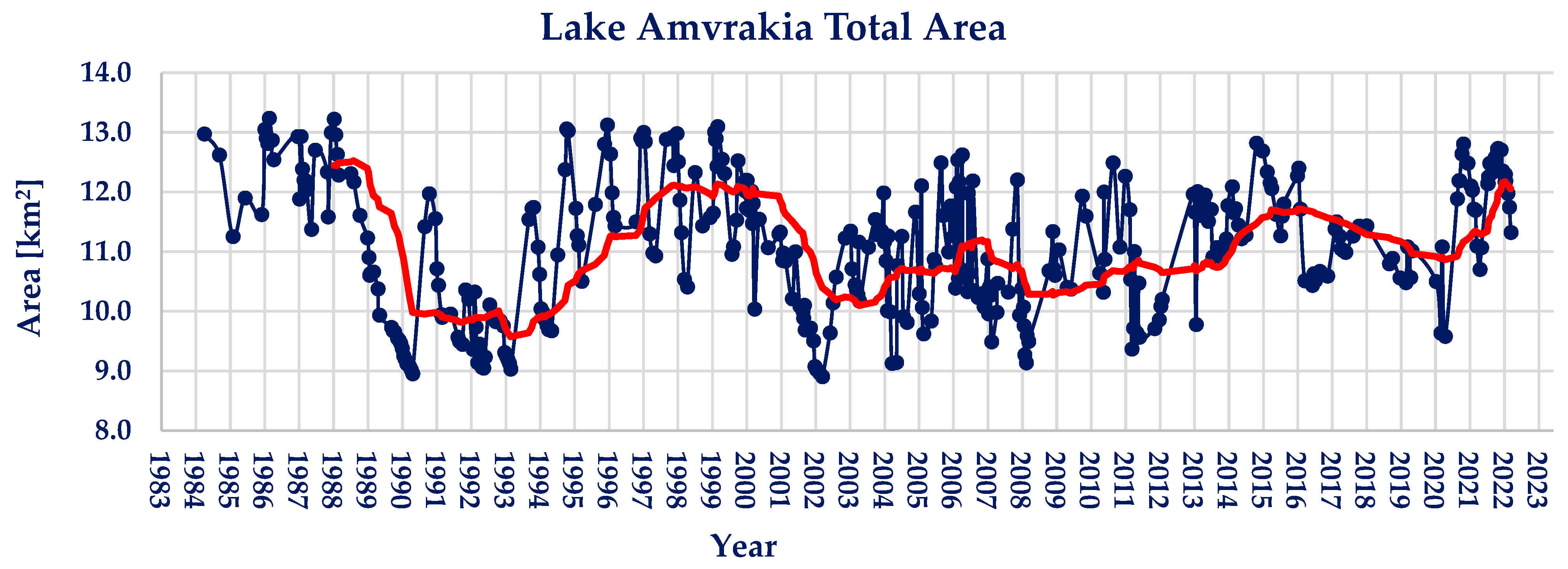
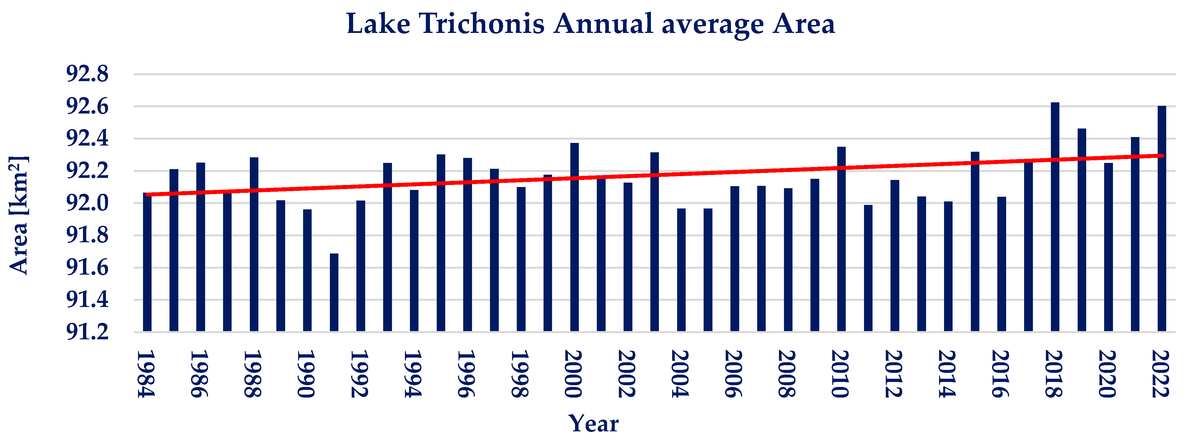
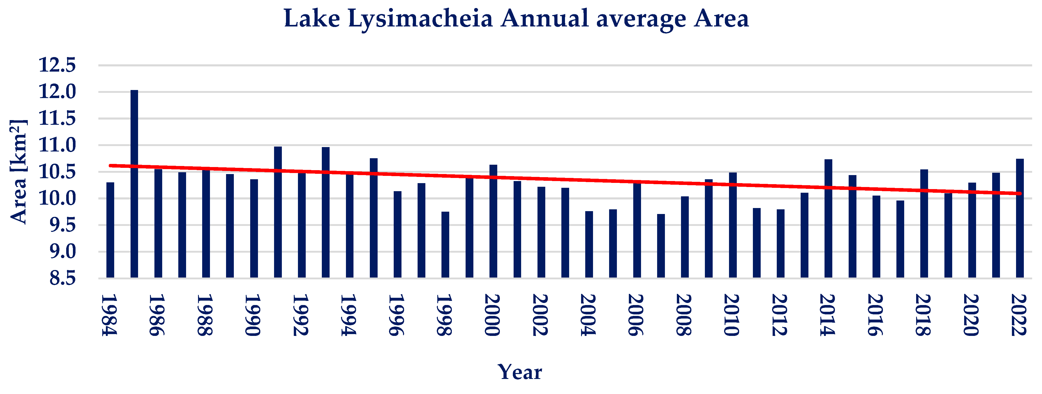
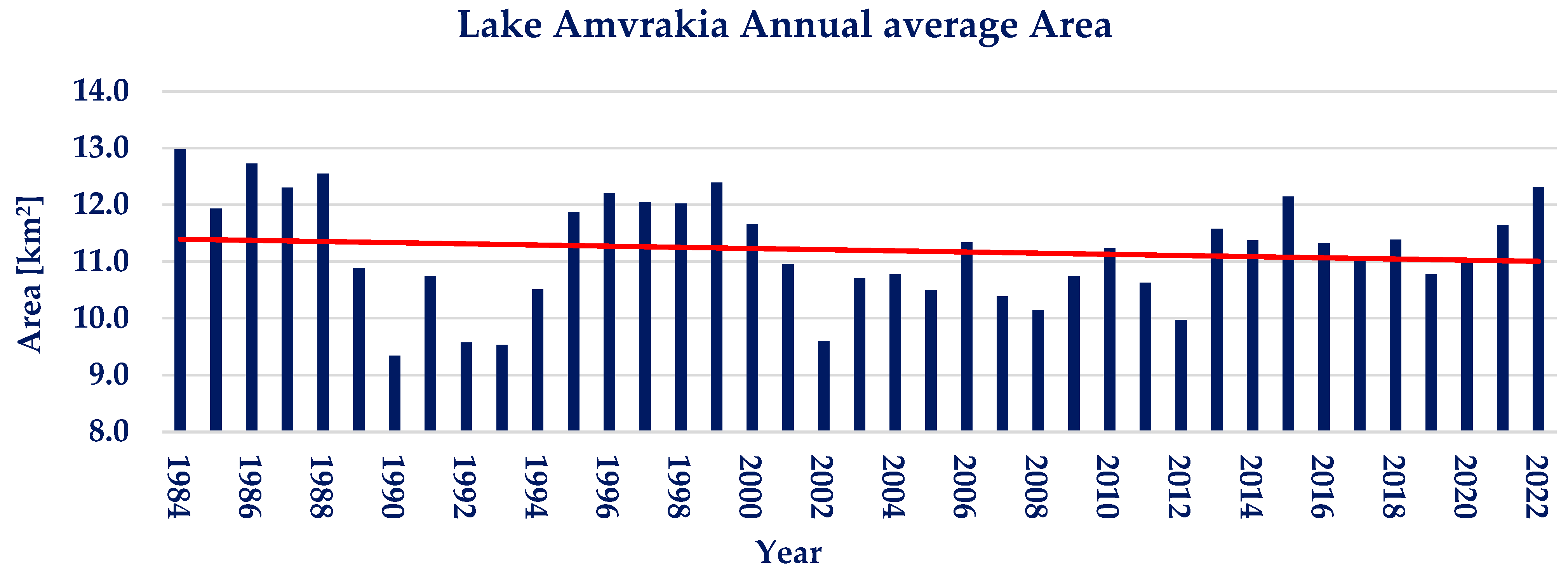
3.1.1. Water Area Timeseries
3.1.2. Annual Water Area Trend Analysis
3.1.3. Seasonality Trend Analysis
3.2. Further Investigation
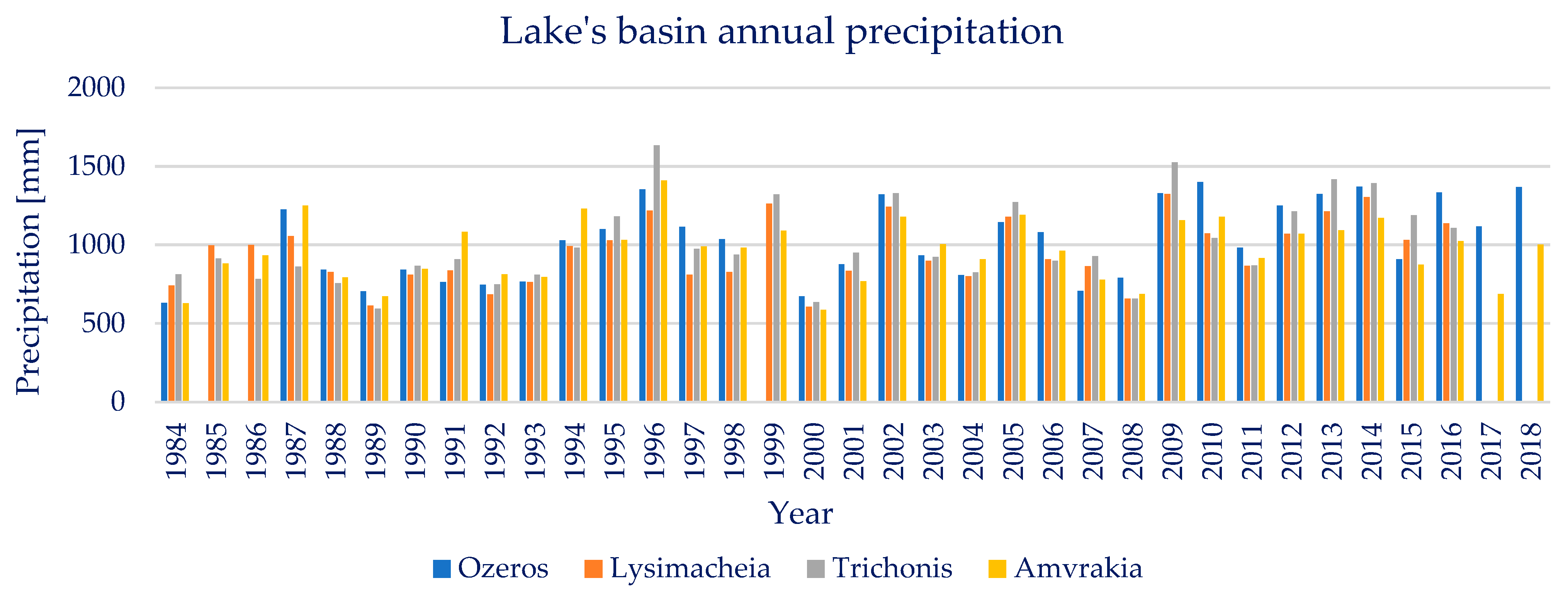
3.2.1. Precipitation
3.2.2. Temperature
3.2.3. Land Cover
4. Discussion
5. Conclusions
- Between 1984 and 2022, the maximum and minimum water area variations compared to average water area for lakes Trichonis, Lysimacheia, Ozeros and Amvrakia, were +1.38% to −3.86%, +39.61% to −32.37%, +4.81% to 4.43% and +19.34% to −19.71% respectively.
- Annual average trend analysis conducted on the Landsat derived water area timeseries, resulted in p ≈ 1 and ZMK equal to −0.33, −5.07, +0.36 and +1.87 for the four lakes respectively, depicting the absence of statistically significant quantitative trends.
- Seasonal trend analysis conducted on the Landsat derived water area timeseries did not again show a statistically significant quantitative trend.
- The climate variable of precipitation did not reveal a statistically significant trend during years from 1984 to 2016–2019, in annual and seasonal scale.
- The climate variable of temperature did not reveal a statistically significant trend during years from 1984 to 2022, in annual, seasonal and monthly scale.
- Land use change from 1990 to 2018 revealed a generally stable land environment, with neglible to small increases of artificial and natural areas with a simultaneous decrease of agricultural areas.
Author Contributions
Funding
Institutional Review Board Statement
Informed Consent Statement
Data Availability Statement
Conflicts of Interest
References
- Williamson, C.E.; Saros, J.E.; Vincent, W.F.; Smol, J.P. Lakes and Reservoirs as Sentinels, Integrators, and Regulators of Climate Change. Limnol. Oceanogr. 2009, 54, 2273–2282. [Google Scholar] [CrossRef]
- Busker, T.; de Roo, A.; Gelati, E.; Schwatke, C.; Adamovic, M.; Bisselink, B.; Pekel, J.-F.; Cottam, A. A Global Lake and Reservoir Volume Analysis Using a Surface Water Dataset and Satellite Altimetry. Hydrol. Earth Syst. Sci. Discuss. 2018, 23, 1–32. [Google Scholar] [CrossRef]
- Frappart, F.; Zeiger, P.; Betbeder, J.; Gond, V.; Bellot, R.; Baghdadi, N.; Blarel, F.; Darrozes, J.; Bourrel, L.; Seyler, F. Automatic Detec-Tion of Inland Water Bodies along Altimetry Tracks for Estimating Surface Water Storage Variations in the Congo Basin. Remote Sens. 2021, 10, 3804. [Google Scholar] [CrossRef]
- Zhong, S.; Geng, Y.; Qian, Y.; Chen, W.; Pan, H. Analyzing Ecosystem Services of Freshwater Lakes and Their Driving Forces: The Case of Erhai Lake, China. Environ. Sci. Pollut. Res. 2019, 26, 10219–10229. [Google Scholar] [CrossRef] [PubMed]
- Kostianoy, A.G.; Lebedev, S.A.; Kostianaia, E.A.; Prokofiev, Y.A. Interannual Variability of Water Level in Two Largest Lakes of Europe. Remote Sens. 2022, 14, 659. [Google Scholar] [CrossRef]
- Gourgouletis, N.; Bariamis, G.; Baltas, E. Estimation of Characteristics of Surface Water Bodies Based on Sentinel-2 Images: The Case Study of Yliki Reservoir. In Proceedings of the Eigth International Conference on Environmental Management, Engineering, Planning & Economics, Thessaloniki, Greece, 20–24 July 2021; pp. 551–558. [Google Scholar]
- Schmitz, O.J.; Raymond, P.A.; Estes, J.A.; Kurz, W.A.; Holtgrieve, G.W.; Ritchie, M.E.; Schindler, D.E.; Spivak, A.C.; Wilson, R.W.; Bradford, M.A.; et al. Animating the Carbon Cycle. Ecosystems 2014, 17, 344–359. [Google Scholar] [CrossRef]
- Jimenez Cisneros, B.E.; Oki, T.; Arnell, N.W.; Benito, G.; Cogley, J.G.; Döll, P.; Jiang, T.; Mwakalila, S.S. Freshwater Resources. In Climate Change 2014: Impacts, Adaptation, and Vulnerability. Part A: Global and Sectoral Aspects. Contribution of Working Group II to the Fifth Assessment Report of the Intergovernmental Panel on Climate Change; Field, C.B., Barros, V.R., Dokken, D.J., Mach, K.J., Mastrandrea, M.D., Bilir, T.E., Chatterjee, M., Ebi, K.L., Estrada, Y.O., Genova, R.C., et al., Eds.; Cambridge University Press: Cambridge, UK; New York, NY, USA, 2014; pp. 1199–1265. [Google Scholar]
- Kovats, R.S.; Valentini, R.; Bouwer, L.M.; Georgopoulou, E.; Jacob, D.; Martin, E.; Rounsevell, M.; Soussana, J.-F. Europe. In Climate Change 2014: Impacts, Adaptation, and Vulnerability. Part B: Regional Aspects. Contribution of Working Group II to the Fifth Assessment Report of the Intergovernmental Panel on Climate Change; Field, C.B., Barros, V.R., Dokken, D.J., Mach, K.J., Mastrandrea, M.D., Bilir, T.E., Chatterjee, M., Ebi, K.L., Estrada, Y.O., Genova, R.C., et al., Eds.; Cambridge University Press: Cambridge, UK; New York, NY, USA, 2014; pp. 1267–1326. [Google Scholar]
- Gutiérrez, J.M.; Mernild, S.H.; Jones, R.G.; Narisma, G.T.; Alves, L.M.; Amjad, M.; Gorodetskaya, I.V.; Grose, M.; Klutse, N.A.B.; Krakovska, S.; et al. Atlas. In Climate Change 2021: The Physical Science Basis. Contribution of Working Group I to the Sixth Assessment Report of the Intergovernmental Panel on Climate Change; Masson-Delmotte, V., Zhai, P., Pirani, A., Connors, S., Péan, C., Berger, S., Caud, N., Chen, Y., Goldfarb, L., Gomis, M., Eds.; Cambridge University Press: Cambridge, UK, 2021; pp. 1927–2058. [Google Scholar]
- Ali, E.; Cramer, W.; Carnicer, J.; Georgopoulou, E.; Hilmi, N.J.M.; le Cozannet, G.; Lionello, P.; Pörtner, H.-O.; Roberts, D.C.; Tignor, M.; et al. Cross-Chapter Paper 4: Mediterranean Region. In Climate Change 2022: Impacts, Adaptation and Vulnerability. Contribution of Working Group II to the Sixth Assessment Report of the Intergovernmental Panel on Climate Change; Cambridge University Press: Cambridge, UK, 2022; pp. 2233–2272. [Google Scholar]
- Weatherhead, E.K.; Howden, N.J.K. The Relationship between Land Use and Surface Water Resources in the UK. Land Use Policy 2009, 26, S243–S250. [Google Scholar] [CrossRef]
- Thornton, P.K.; Herrero, M. The Inter-Linkages between Rapid Growth in Livestock Production, Climate Change, and the Impacts on Water Resources, Land Use, and Deforestation Background Paper to the 2010 World Development Report; 2010; The World Bank: Washington, DC, USA, 2010. [Google Scholar]
- Khazaei, B.; Khatami, S.; Alemohammad, S.H.; Rashidi, L.; Wu, C.; Madani, K.; Kalantari, Z.; Destouni, G.; Aghakouchak, A. Climatic or Regionally Induced by Humans? Tracing Hydro-Climatic and Land-Use Changes to Better Understand the Lake Urmia Tragedy. J. Hydrol. 2019, 569, 203–217. [Google Scholar] [CrossRef]
- Satgé, F.; Espinoza, R.; Zolá, R.P.; Roig, H.; Timouk, F.; Molina, J.; Garnier, J.; Calmant, S.; Seyler, F.; Bonnet, M.P. Role of Climate Variability and Human Activity on Poopó Lake Droughts between 1990 and 2015 Assessed Using Remote Sensing Data. Remote Sens. 2017, 9, 218. [Google Scholar] [CrossRef]
- Bariamis, G.; Paschos, G.; Baltas, E. Land Accounts in the River Basin Districts of Greece. Environ. Process. 2018, 5, 213–237. [Google Scholar] [CrossRef]
- OECD. Water and Climate Change Adaptation; OECD Studies on Water; OECD: Paris, France, 2013; ISBN 9789264200432. [Google Scholar]
- Karavitis, C.A.; Chortaria, C.; Alexandris, S.; Vasilakou, C.G.; Tsesmelis, D.E. Development of the Standardised Precipitation Index for Greece. Urban Water J. 2012, 9, 401–417. [Google Scholar] [CrossRef]
- Livada, I.; Assimakopoulos, V.D. Spatial and Temporal Analysis of Drought in Greece Using the Standardized Precipitation Index (SPI). Appl. Clim. 2007, 89, 143–153. [Google Scholar] [CrossRef]
- Kalamaras, N.; Michalopoulou, H.; Byun, H.R. Detection of Drought Events in Greece Using Daily Precipitation. Hydrol. Res. 2010, 41, 126–133. [Google Scholar] [CrossRef]
- Terzidis, G. Water Scarcity; Causes, Forecasting Potential and Mitigation Measures in the Urban and Agricultural Development of Greece. In Water Scarcity and Floods; Geotechnical Chamber of Greece: Thessaloniki, Greece, 1992; pp. 25–40. [Google Scholar]
- Biswas, A.K. Integrated Water Resources Management: A Reassessment. Water Int. 2004, 29, 248–256. [Google Scholar] [CrossRef]
- Schwatke, C.; Dettmering, D.; Bosch, W.; Seitz, F. DAHITI—An Innovative Approach for Estimating Water Level Time Series over Inland Waters Using Multi-Mission Satellite Altimetry. Hydrol. Earth Syst. Sci. 2015, 19, 4345–4364. [Google Scholar] [CrossRef]
- Chawla, I.; Karthikeyan, L.; Mishra, A.K. A Review of Remote Sensing Applications for Water Security: Quantity, Quality, and Extremes. J. Hydrol. 2020, 585, 124826. [Google Scholar] [CrossRef]
- Baup, F.; Frappart, F.; Maubant, J. Combining High-Resolution Satellite Images and Altimetry to Estimate the Volume of Small Lakes. Hydrol. Earth Syst. Sci. 2014, 18, 2007–2020. [Google Scholar] [CrossRef]
- Yang, X.; Zhao, S.; Qin, X.; Zhao, N.; Liang, L. Mapping of Urban Surface Water Bodies from Sentinel-2 MSI Imagery at 10 m Resolution via NDWI-Based Image Sharpening. Remote Sens. 2017, 9, 596. [Google Scholar] [CrossRef]
- Cavallo, C.; Papa, M.N.; Gargiulo, M.; Palau-Salvador, G.; Vezza, P.; Ruello, G. Continuous Monitoring of the Flooding Dynamics in the Albufera Wetland (Spain) by Landsat-8 and Sentinel-2 Datasets. Remote Sens. 2021, 13, 3525. [Google Scholar] [CrossRef]
- McFeeters, S.K. The Use of the Normalized Difference Water Index (NDWI) in the Delineation of Open Water Features. Int. J. Remote Sens. 1996, 17, 1425–1432. [Google Scholar] [CrossRef]
- Sekertekin, A. A Survey on Global Thresholding Methods for Mapping Open Water Body Using Sentinel-2 Satellite Imagery and Normalized Difference Water Index. Arch. Comput. Methods Eng. 2020, 28, 1335–1347. [Google Scholar] [CrossRef]
- Gourgouletis, N.; Bariamis, G.; Anagnostou, M.N.; Baltas, E. Estimating Reservoir Storage Variations by Combining Sentinel-2 and 3 Measurements in the Yliki Reservoir, Greece. Remote Sens. 2022, 14, 1860. [Google Scholar] [CrossRef]
- Du, Y.; Zhang, Y.; Ling, F.; Wang, Q.; Li, W.; Li, X. Water Bodies’ Mapping from Sentinel-2 Imagery with Modified Normalized Difference Water Index at 10-m Spatial Resolution Produced by Sharpening the Swir Band. Remote Sens. 2016, 8, 354. [Google Scholar] [CrossRef]
- Acharya, T.D.; Subedi, A.; Lee, D.H. Evaluation of Water Indices for Surface Water Extraction in a Landsat 8 Scene of Nepal. Sensors 2018, 18, 2580. [Google Scholar] [CrossRef]
- Mehmood, H.; Conway, C.; Perera, D. Mapping of Flood Areas Using Landsat with Google Earth Engine Cloud Platform. Atmosphere 2021, 12, 866. [Google Scholar] [CrossRef]
- Ichsan Ali, M.; Darma Dirawan, G.; Hafid Hasim, A.; Rais Abidin, M. Detection of Changes in Surface Water Bodies Urban Area with NDWI and MNDWI Methods. Int. J. Adv. Sci. Eng. Inf. Technol. 2019, 9, 946. [Google Scholar]
- Deoli, V.; Kumar, D.; Kuriqi, A. Detection of Water Spread Area Changes in Eutrophic Lake Using Landsat Data. Sensors 2022, 22, 6827. [Google Scholar] [CrossRef] [PubMed]
- Schmitt, M. Potential of Large-Scale Inland Water Body Mapping from Sentinel-1/2 Data on the Example of Bavaria’s Lakes and Rivers. PFG-J. Photogramm. Remote Sens. Geoinf. Sci. 2020, 88, 271–289. [Google Scholar] [CrossRef]
- Xu, H. Modification of Normalised Difference Water Index (NDWI) to Enhance Open Water Features in Remotely Sensed Imagery. Int. J. Remote Sens. 2006, 27, 3025–3033. [Google Scholar] [CrossRef]
- Soria, J.; Apostolova, N. Decrease in the Water Level of Lake Prespa (North Macedonia) Studied by Remote Sensing Methodology: Relation with Hydrology and Agriculture. Hydrology 2022, 9, 99. [Google Scholar] [CrossRef]
- Markogianni, V.; Kalivas, D.; Petropoulos, G.P.; Dimitriou, E. Modelling of Greek Lakes Water Quality Using Earth Observation in the Framework of the Water Framework Directive (WFD). Remote Sens. 2022, 14, 739. [Google Scholar] [CrossRef]
- Peppa, M.; Vasilakos, C.; Kavroudakis, D. Eutrophication Monitoring for Lake Pamvotis, Greece, Using Sentinel-2 Data. ISPRS Int. J. Geoinf. 2020, 9, 143. [Google Scholar] [CrossRef]
- Alexandridis, T.K.; Takavakoglou, V.; Crisman, T.L.; Zalidis, G.C. Remote Sensing and GIS Techniques for Selecting a Sustainable Scenario for Lake Koronia, Greece. Environ. Manag. 2007, 39, 278–290. [Google Scholar] [CrossRef]
- Papastergiadou, E.S.; Retalis, A.; Apostolakis, A.; Georgiadis, T. Environmental Monitoring of Spatio-Temporal Changes Using Remote Sensing and GIS in a Mediterranean Wetland of Northern Greece. Water Resour. Manag. 2008, 22, 579–594. [Google Scholar] [CrossRef]
- Psomiadis, E.; Soulis, K.X.; Zoka, M.; Dercas, N. Synergistic Approach of Remote Sensing and Gis Techniques for Flash-Flood Monitoring and Damage Assessment in Thessaly Plain Area, Greece. Water 2019, 11, 448. [Google Scholar] [CrossRef]
- Capolongo, D.; Refice, A.; Bocchiola, D.; D’Addabbo, A.; Vouvalidis, K.; Soncini, A.; Zingaro, M.; Bovenga, F.; Stamatopoulos, L. Coupling Multitemporal Remote Sensing with Geomorphology and Hydrological Modeling for Post Flood Recovery in the Strymonas Dammed River Basin (Greece). Sci. Total Environ. 2019, 651, 1958–1968. [Google Scholar] [CrossRef] [PubMed]
- Kontopoulou, E.; Kolokoussis, P.; Karantzalos, K. Water Quality Estimation in Greek Lakes from Landsat 8 Multispectral Satellite Data. Eur. Water 2017, 58, 191–196. [Google Scholar]
- Elhag, M.; Yilmaz, N. Insights of Remote Sensing Data to Surmount Rainfall/Runoff Data Limitations of the Downstream Catchment of Pineios River, Greece. Environ. Earth Sci. 2021, 80, 35. [Google Scholar] [CrossRef]
- Valero-Jorge, A.; González-De Zayas, R.; Alcántara-Martín, A.; Álvarez-Taboada, F.; Matos-Pupo, F.; Brown-Manrique, O. Water Area and Volume Calculation of Two Reservoirs in Central Cuba Using Remote Sensing Methods. A New Perspective. Rev. Teledetec. 2022, 2022, 71–87. [Google Scholar] [CrossRef]
- Walker, D.; Shutler, J.D.; Morrison, E.H.J.; Harper, D.M.; Hoedjes, J.C.B.; Laing, C.G. Quantifying Water Storage within the North of Lake Naivasha Using Sonar Remote Sensing and Landsat Satellite Data. Ecohydrol. Hydrobiol. 2021, 22, 12–20. [Google Scholar] [CrossRef]
- Lin, Y.; Li, X.; Zhang, T.; Chao, N.; Yu, J.; Cai, J.; Sneeuw, N. Water Volume Variations Estimation and Analysis Using Multisource Satellite Data: A Case Study of Lake Victoria. Remote Sens. 2020, 12, 3052. [Google Scholar] [CrossRef]
- Crétaux, J.F.; Abarca-del-Río, R.; Bergé-Nguyen, M.; Arsen, A.; Drolon, V.; Clos, G.; Maisongrande, P. Lake Volume Monitoring from Space. Surv. Geophys. 2016, 37, 269–305. [Google Scholar] [CrossRef]
- 1st Revision RBDMP of Western Greece. Greek Gov. Gaz. 2017, 4681 B, 65633–65920. (In Greek)
- Perivolioti, T.M.; Frouzova, J.; Tušer, M.; Bobori, D. Assessing the Fish Stock Status in Lake Trichonis: A Hydroacoustic Approach. Water 2020, 12, 1823. [Google Scholar] [CrossRef]
- Petriki, O.; Moutopoulos, D.K.; Tsagarakis, K.; Tsionki, I.; Papantoniou, G.; Mantzouni, I.; Barbieri, R.; Stoumboudi, M.T. Assessing the Fisheries and Ecosystem Structure of the Largest Greek Lake (Lake Trichonis). Water 2021, 13, 3329. [Google Scholar] [CrossRef]
- Special Secreteriat for Water (In Greek). 1st Revision RBDMP of Western Greece; Deliverable 05-M2; Analysis of Human Induced Pressures and Impacts on Surface and Underground Water Bodies; Hellenic Ministry of Environment and Energy: Athens, Greece, 2017. [Google Scholar]
- Special Secretariat for Water (In Greek). 1st Revision RBDMP of Western Greece; Deliverable 06-M2; Characterization, Typology and Evaluation/Ranking of the Status of Surface Water Bodies; Hellenic Ministry of Environment and Energy: Athens, Greece, 2017. [Google Scholar]
- Scaramuzza, P.; Micijevic, E.; Chander, G. SLC Gap-Filled Products; Phase One Methodology; USGS: Reston, VA, USA, 2004. [Google Scholar]
- Khaki, M.; Awange, J. The 2019–2020 Rise in Lake Victoria Monitored from Space: Exploiting the State-of-the-Art Grace-Fo and the Newly Released Era-5 Reanalysis Products. Sensors 2021, 21, 4304. [Google Scholar] [CrossRef]
- Cerlini, P.B.; Saraceni, M.; Silvestri, L.; Meniconi, S.; Brunone, B. Monitoring the Water Mass Balance Variability of Small Shallow Lakes by an ERA5-Land Reanalysis and Water Level Measurement-Based Model. An Application to the Trasimeno Lake, Italy. Atmosphere 2022, 13, 949. [Google Scholar] [CrossRef]
- Büttner, G.; Kosztra, B.; Maucha, G.; Pataki, R.; Kleeschulte, S.; Hazeu, G.; Vittek, M.; Littkopf, A. Copernicus Land Monitoring Service; European Environment Agency: Copenhagen, Denmark, 2021. [Google Scholar]
- Prewitt, J.M.S.; Mendelsohn, M.L. The analysis of cell images. Ann. N. Y. Acad. Sci. 2006, 128, 1035–1053. [Google Scholar] [CrossRef]
- Mann, H.B. Nonparametric Tests Against Trend. Econometrica 1945, 13, 245. [Google Scholar] [CrossRef]
- Kendall, M.G. Rank Correlation Methods, 4th ed.; Griffin: London, UK, 1975; ISBN 9780852641996. [Google Scholar]
- Pettitt, A.N. A Non-Parametric Approach to the Change-Point Problem. Appl. Stat. 1979, 28, 126. [Google Scholar] [CrossRef]
- Gagnon, A.S.; Gough, W.A. Hydro-Climatic Trends in the Hudson Bay Region, Canada. Can. Water Resour. J. 2002, 27, 245–262. [Google Scholar] [CrossRef]
- Tadese, M.T.; Kumar, L.; Koech, R.; Zemadim, B. Hydro-Climatic Variability: A Characterisation and Trend Study of the Awash River Basin, Ethiopia. Hydrology 2019, 6, 35. [Google Scholar] [CrossRef]
- Okafor, G.C.; Jimoh, O.D.; Larbi, K.I. Detecting Changes in Hydro-Climatic Variables during the Last Four Decades (1975-2014) on Downstream Kaduna River Catchment, Nigeria. Atmos. Clim. Sci. 2017, 7, 161–175. [Google Scholar] [CrossRef]
- Tekleab, S.; Mohamed, Y.; Uhlenbrook, S. Hydro-Climatic Trends in the Abay/Upper Blue Nile Basin, Ethiopia. Phys. Chem. Earth 2013, 61–62, 32–42. [Google Scholar] [CrossRef]
- Hirsch, R.M.; Slack, J.R. A Nonparametric Trend Test for Seasonal Data With Serial Dependence. Water Resour. Res. 1984, 20, 727–732. [Google Scholar] [CrossRef]
- Lv, A.; Zhang, C. Analysis of the Characteristics and Driving Forces of Changes in Lake Water Volume in Inland Arid Basins in China. Water 2022, 14, 3141. [Google Scholar] [CrossRef]


| Landsat | Green [μm] | SWIR [μm] |
|---|---|---|
| 4, 5—Thematic Mapper | B2 (0.52–0.60) | B5 (1.55–1.75) |
| 7—ETM+ | B2 (0.52–0.60) | B5 (1.55–1.75) |
| 8, 9—OLI | B3 (0.53–0.59) | B6 (1.57–1.65) |
| Lake/Basin | Water Area | Precipitation | Temperature | |||
|---|---|---|---|---|---|---|
| p | ZMK | p | ZMK | p | ZMK | |
| Trichonis | ≈1 | 1.84 | ≈1 | 2.80 | ≈1 | 4.65 |
| Lysimacheia | ≈1 | −2.06 | ≈1 | 2.37 | ≈1 | 4.52 |
| Ozeros | ≈1 | −0.60 | ≈1 | 3.13 | ≈1 | 4.45 |
| Amvrakia | ≈1 | −0.73 | ≈1 | 1.60 | ≈1 | 4.50 |
Disclaimer/Publisher’s Note: The statements, opinions and data contained in all publications are solely those of the individual author(s) and contributor(s) and not of MDPI and/or the editor(s). MDPI and/or the editor(s) disclaim responsibility for any injury to people or property resulting from any ideas, methods, instructions or products referred to in the content. |
© 2023 by the authors. Licensee MDPI, Basel, Switzerland. This article is an open access article distributed under the terms and conditions of the Creative Commons Attribution (CC BY) license (https://creativecommons.org/licenses/by/4.0/).
Share and Cite
Gourgouletis, N.; Baltas, E. Investigating Hydroclimatic Variables Trends on the Natural Lakes of Western Greece Using Earth Observation Data. Sensors 2023, 23, 2056. https://doi.org/10.3390/s23042056
Gourgouletis N, Baltas E. Investigating Hydroclimatic Variables Trends on the Natural Lakes of Western Greece Using Earth Observation Data. Sensors. 2023; 23(4):2056. https://doi.org/10.3390/s23042056
Chicago/Turabian StyleGourgouletis, Nikolaos, and Evangelos Baltas. 2023. "Investigating Hydroclimatic Variables Trends on the Natural Lakes of Western Greece Using Earth Observation Data" Sensors 23, no. 4: 2056. https://doi.org/10.3390/s23042056
APA StyleGourgouletis, N., & Baltas, E. (2023). Investigating Hydroclimatic Variables Trends on the Natural Lakes of Western Greece Using Earth Observation Data. Sensors, 23(4), 2056. https://doi.org/10.3390/s23042056