
Land Use Planning to Reduce Flood Risk: Opportunities, Challenges and Uncertainties in Developing Countries

 ,
, 
 ,
, 
Abstract
:1. Introduction
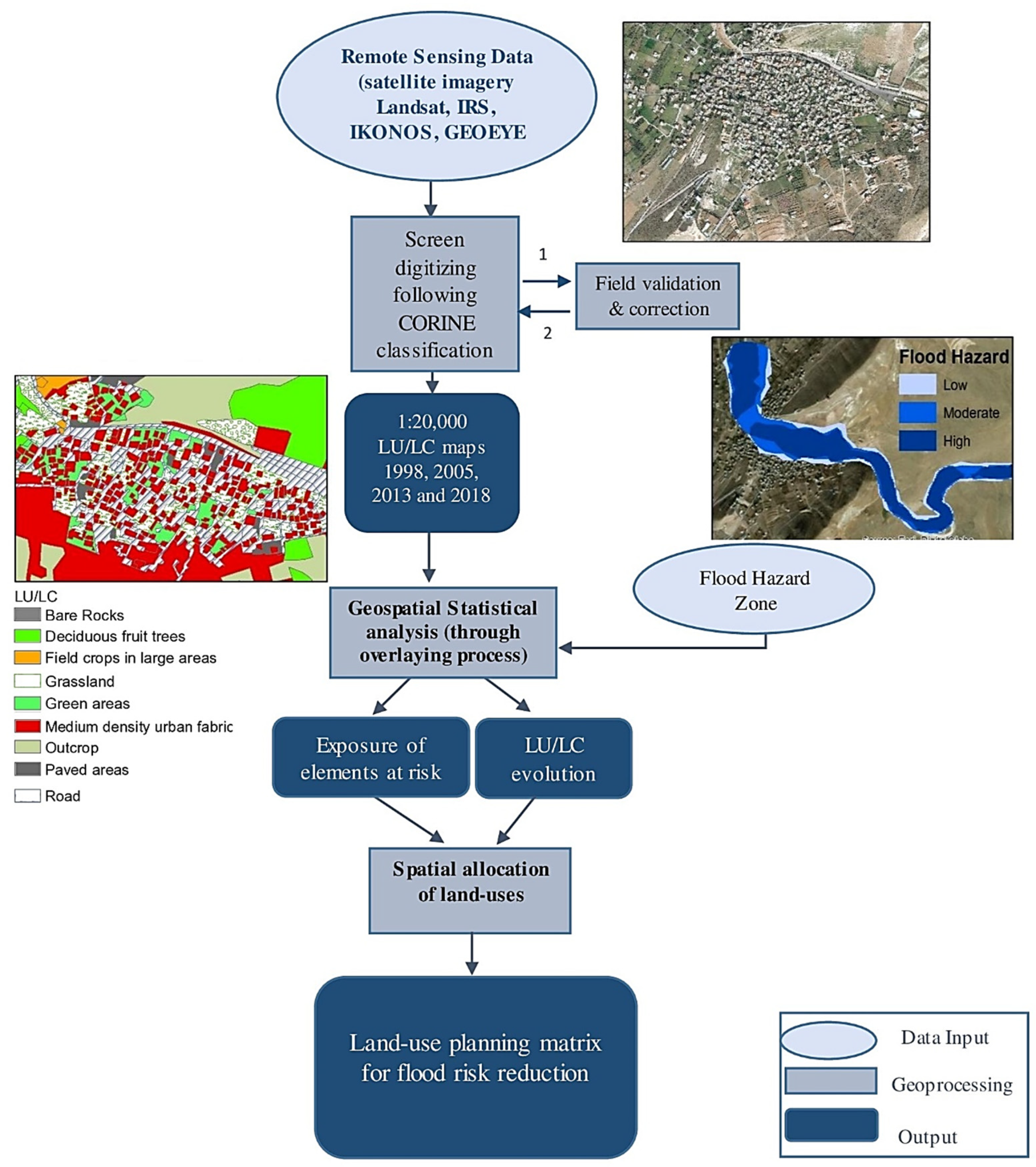
2. Materials and Methods
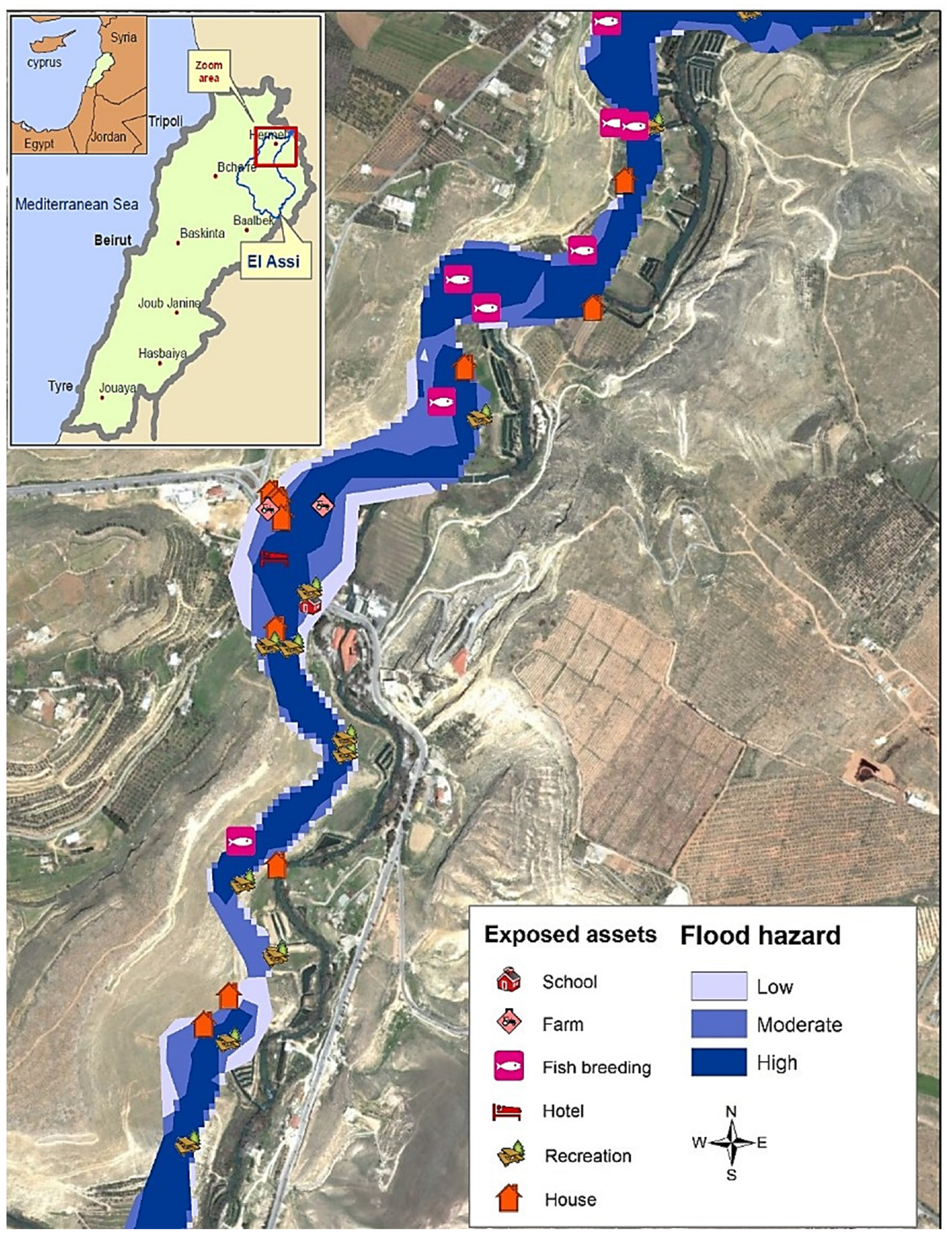
2.1. Study Area
2.2. Dataset and Methodology
3. Results and Discussion
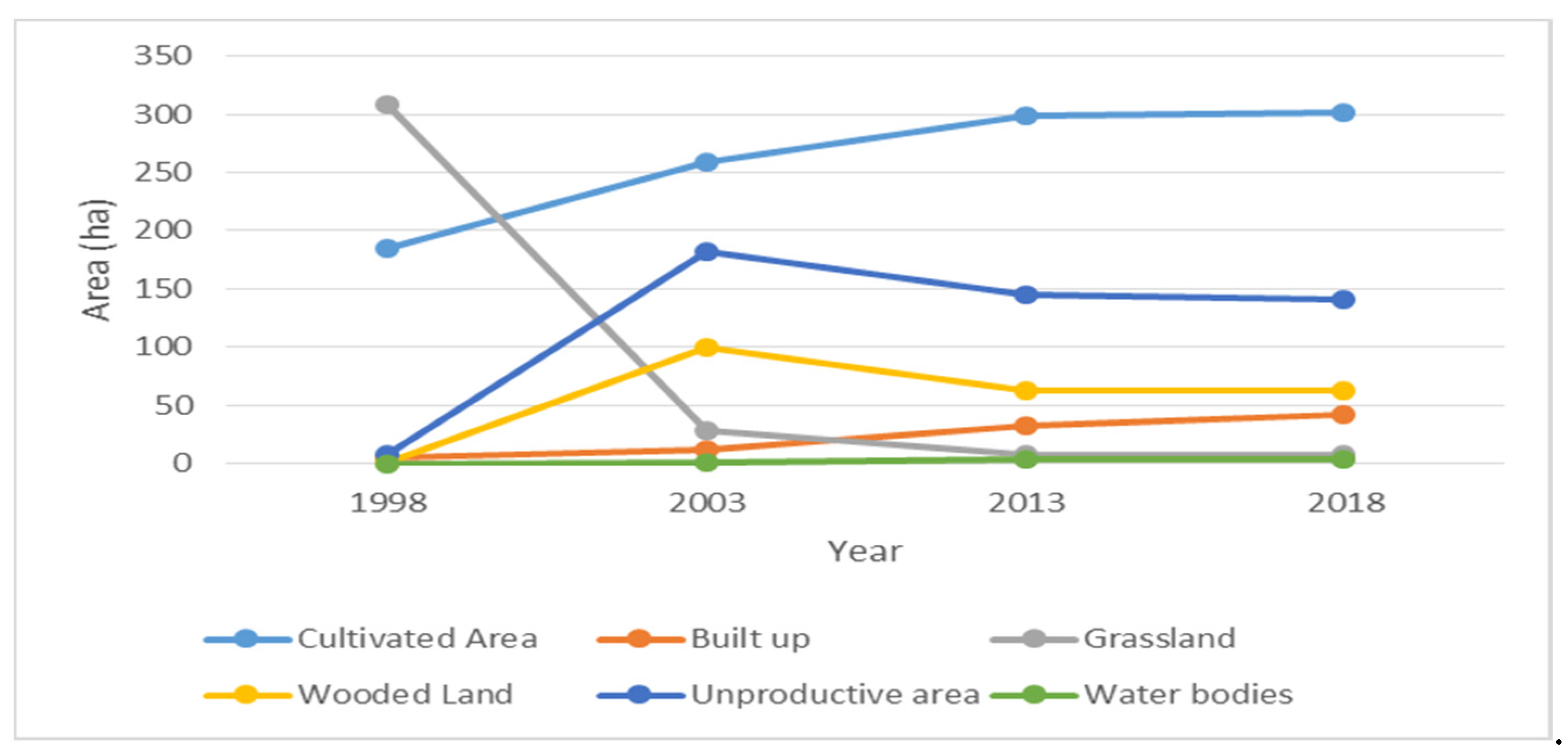
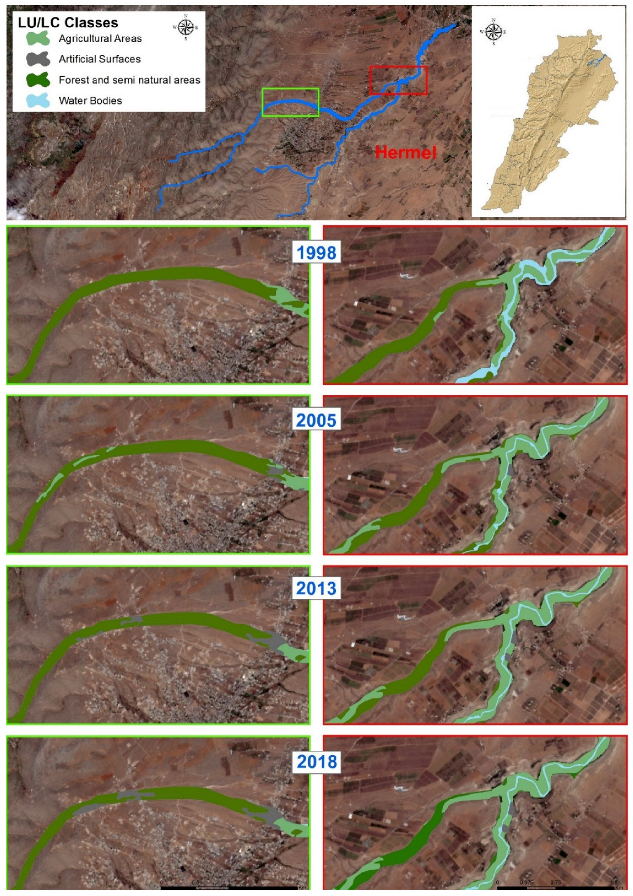
3.1. Land Cover Dynamics and Position with Respect to Flood Levels
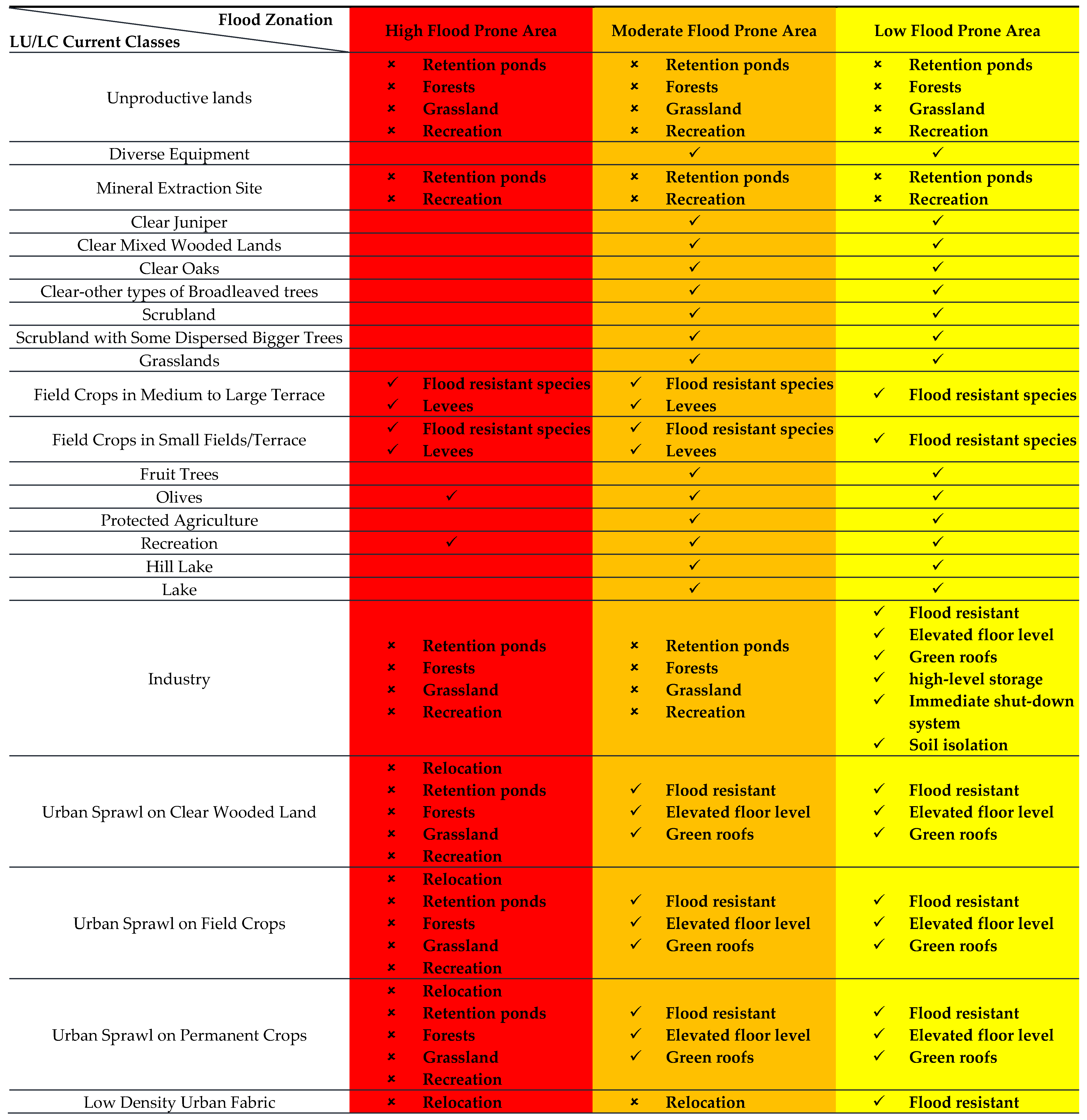
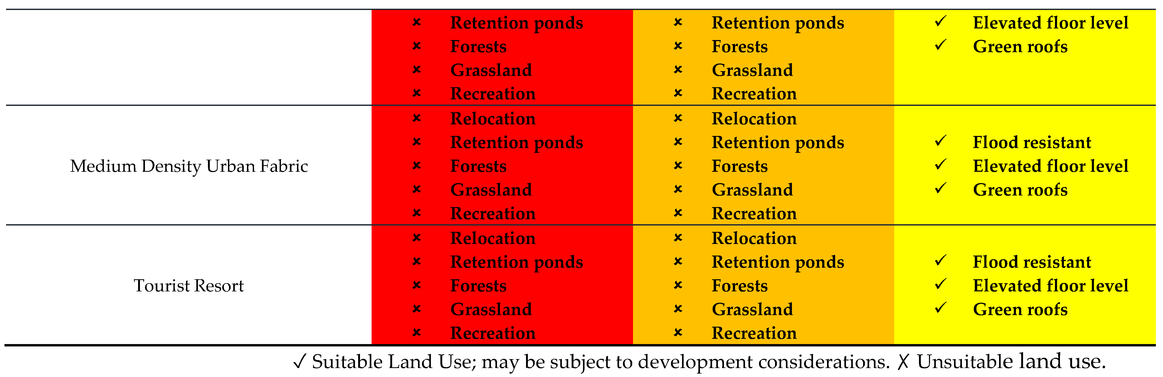
3.2. Hazard-Informed Land Use Planning Matrix
- Benefit as much as possible from waterfront touristic, economic, and recreational activities, along with the services offered by the ecosystem.
- Protect people and properties by following three basic principles: (a) Safe location, (b) Safe construction, and (c) Safe activities (landscaping and design of drainage and natural flood retention zones).
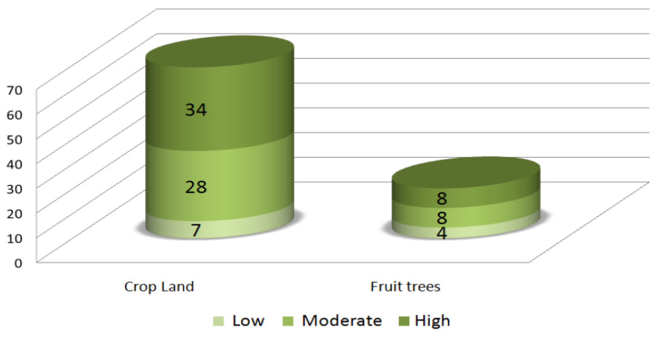
- High exposure areas are assigned to low-occupancy uses such as recreational activities, ecosystem-based livelihoods involving agriculture, or ecotourism riparian activities. In these areas most development is restricted, and existing development must be prioritized for protection and retrofitting.
- In moderate exposure areas, a “living with water” approach should be adopted through development controls, flood-resistant building codes, and green infrastructure (where possible) for decreasing impermeable surfaces and ameliorating the connectivity between green spaces.
- In low exposure areas, preventive relocation and urban growth is possible with development controls, including strictly enforced building codes, mandatory flood insurance programs, etc.
3.3. Application, Advantages, and Limitations of the Approach
3.3.1. Climate Change
3.3.2. Continuous Updates
3.3.3. Poor Land Tenureship and Contentious Ownership
3.3.4. Societal Unacceptance/Locals’ Consent
3.3.5. Relocation and Resettlements
3.3.6. Lack of Flood Insurance
3.3.7. Political and Legal Implications
3.3.8. Jurisdictional and Risk Borders
4. Conclusions
Author Contributions
Funding
Institutional Review Board Statement
Informed Consent Statement
Data Availability Statement
Acknowledgments
Conflicts of Interest
References
- Menoni, S. Land Use Planning in Hazard Mitigation: Intervening in Social and Systemic Vulnerabilities—An Application to Seismic Risk Prevention. In Natural Disasters and Sustainable Development; Springer Science & Business Media: Berlin/Heidelberg, Germany, 2004; pp. 165–182. [Google Scholar]
- Donovan, J. Designing to Heal: Planning and Urban Design Response to Disaster and Conflict; Csiro Publishing: Clayton, Australia, 2013; ISBN 9780643106475. [Google Scholar]
- Garrido, J.; Saunders, W.S.A. Disaster Risk Reduction and Land Use Planning: Opportunities to Improve Practice. In IAEG/AEG Annual Meeting Proceedings, San Francisco, California, 2018—Volume 5; Springer International Publishing: Cham, Switzerland, 2019; pp. 161–165. [Google Scholar]
- United Nations Office for Disaster Risk Reduction. Sendai Framework for Disaster Risk Reduction 2015–2030; United Nations Office for Disaster Risk Reduction: Geneva, Switzerland, 2015; pp. 1–25. Available online: https://www.undrr.org/publication/sendai-framework-disaster-risk-reduction-2015-2030 (accessed on 6 August 2022).
- UNECE. Spatial Planning—Key Instrument for Development and Effective Governance with Special Reference to Countries in Transition; United Nations Economic Commission for Europe: Geneva, Switzerland, 2008; pp. 1–56. Available online: https://unece.org/info/Housing-and-Land-Management/pub/2878 (accessed on 6 August 2022).
- Burby, R.J.; Beatley, T.; Berke, P.R.; Deyle, R.E.; French, S.P.; Godschalk, D.R.; Kaiser, E.J.; Kartez, J.D.; May, P.J.; Olshansky, R.; et al. Unleashing the Power of Planning to Create Disaster-Resistant Communities. J. Am. Plan. Assoc. 1999, 65, 247–258. [Google Scholar] [CrossRef]
- Sengezer, B.; Koç, E. A Critical Analysis of Earthquakes and Urban Planning in Turkey. Disasters 2005, 29, 171–194. [Google Scholar] [CrossRef] [PubMed]
- Der Sarkissian, R.; Zaninetti, J.-M.; Abdallah, C. The Use of Geospatial Information as Support for Disaster Risk Reduction; Case Studies from Baalbek-Hermel Governorate/Lebanon. Appl. Geogr. 2019, 111, 102075. [Google Scholar] [CrossRef]
- Godschalk, D.R. Urban Hazard Mitigation: Creating Resilient Cities. Nat. Hazards Rev. 2003, 4, 136–143. [Google Scholar] [CrossRef]
- Burby, R.G. It’s Official: Planning Helps to Reduce Property Losses. Planning 2005, 71, 18. [Google Scholar]
- Langemeyer, J.; Madrid-Lopez, C.; Mendoza Beltran, A.; Villalba Mendez, G. Urban Agriculture—A Necessary Pathway towards Urban Resilience and Global Sustainability? Landsc. Urban Plan. 2021, 210, 104055. [Google Scholar] [CrossRef]
- International Strategy for Disaster Reduction. Hyogo Framework for Action 2005–2015: Building the Resilience of Nations and Communities to Disasters, 1st ed.; UNISDR; International Strategy for Disaster Reduction: Kobe, Japan, 2005. [Google Scholar]
- Gaume, E.; Borga, M.; Llassat, M.C.; Maouche, S.; Lang, M.; Diakakis, M. Mediterranean extreme floods and flash floods. In The Mediterranean Region under Climate Change; IRD Editions: Paris, France, 2017; pp. 133–144. [Google Scholar]
- Yang, S.-Y.; Chan, M.-H.; Chang, C.-H.; Hsu, C.-T. A Case Study of Flood Risk Transfer Effect Caused by Land Development in Flood-Prone Lowlands. Nat. Hazards 2018, 91, 863–878. [Google Scholar] [CrossRef]
- Hounkpè, J.; Die Kruger, B.; Afouda, A.A.; Sintondji, L.O.C. Land Use Change Increases Flood Hazard: A Multi-Modelling Approach to Assess Change in Flood Characteristics Driven by Socio-Economic Land Use Change Scenarios. Nat. Hazards 2019, 98, 1021–1050. [Google Scholar] [CrossRef]
- European Commission. Best Practices on Flood Prevention, Protection. 2003; pp. 1–29. Available online: https://ec.europa.eu/environment/water/flood_risk/pdf/flooding_bestpractice.pdf (accessed on 6 August 2022).
- Asian Development Bank. Reducing Disaster Risk by Managing Urban Land Use: Guidance Notes for Planners; Asian Development Bank: Mandaluyong, Philippines, 2016; ISBN 9789292574758. [Google Scholar]
- Der Sarkissian, R.; Dabaj, A.; Diab, Y.; Vuillet, M. Evaluating the Implementation of the “Build-Back-Better” Concept for Critical Infrastructure Systems: Lessons from Saint-Martin’s Island Following Hurricane Irma. Sustainability 2021, 13, 3133. [Google Scholar] [CrossRef]
- Roy, F.; Ferland, Y. Land Use Planning for Disaster Risk Management. L. Tenure J. 2014, 34, 70–103. [Google Scholar]
- Al Sayah, M.J.; Abdallah, C.; Khouri, M.; Nedjai, R.; Darwich, T. On the Use of the Land Degradation Neutrality Concept in Mediterranean Watersheds for Land Restoration and Erosion Counteraction. J. Arid Environ. 2021, 188, 104465. [Google Scholar] [CrossRef]
- Stone, A.; Jenkins, J.; Westerman, J. Local Government Land Use Planning; OECD Publishing: Paris, France, 2006. [Google Scholar]
- OECD. Boosting Disaster Prevention through Innovative Risk Governance: Insights from Austria, France and Switzerland; OECD Publishing: Paris, France, 2017; ISBN 9789264281363. [Google Scholar]
- Douvinet, J.; Defossez, S.; Anselle, A.; Denolle, A.-S. Les Maires Face Aux Plans de Prévention Du Risque Inondation (PPRI). Espac. Geogr. 2011, 40, 31–46. [Google Scholar] [CrossRef]
- Diab, Y.; El Shaarawy, B.; Yousry, S. Informal Settlements in the Arab Region: Towards Arab Cities without Informal Areas; UN-Habitat: Giza, Egypt, 2020. [Google Scholar]
- UFCOP. Land Use Planning for Urban Flood Risk Management; World Bank: Washington, DC, USA, 2017. [Google Scholar]
- DAR-IAURIF. National Physical Master Plan of the Lebanese Territory; Council for Development & Reconstruction: Beirut, Lebanon, 2005.
- Verdeil, E.; Faour, G.; Velut, S. Atlas Du Liban Les Nouveaux Défis; Presses de l’Ifpo, CNRS Liban: Beirut, Lebanon, 2016; ISBN 978-2-35159-717-0. [Google Scholar]
- UN-ESCWA. BGR Inventory of Shared Water Resources in Western Asia; United Nations Economic and Social Commission for Western Asia: Beirut, Lebanon, 2013. [Google Scholar]
- Estephan, C.; Nimah, M.; Farajalla, N.; Karam, F. Rural Development Project. The Upper Bekaa Valley of Lebanon. Orontes River Basin; FAO: Beirut, Lebanon, 2008. [Google Scholar]
- Abdallah, C.; Chorowicz, J.; Boukheir, R.; Dhont, D. Comparative Use of Processed Satellite Images in Remote Sensing of Mass Movements: Lebanon as a Case Study. Int. J. Remote Sens. 2007, 28, 4409–4427. [Google Scholar] [CrossRef]
- Darwish, T.; Zdruli, P.; Saliba, R.; Awad, M.M.; Shaban, A.; Faour, G. Vulnerability to Desertification in Lebanon Based on Geo-Information and Socioeconomic Conditions. J. Environ. Sci. Eng. 2012, B, 851–861. [Google Scholar]
- Faour, G.; Shaban, A.; Darwish, T.; Mhawej, M. Using GIS to Improve Monitoring of Water Quality in El-Assi River. J. Environ. Sci. Eng. A J. Environ. Sci. Eng. 2014, 3, 9–14. [Google Scholar]
- Mander, Ü.; Helming, K.; Wiggering, H. Multifunctional land use: Meeting future demands for landscape goods and services. In Multifunctional Land Use; Springer: Berlin/Heidelberg, Germany, 2007; pp. 1–13. [Google Scholar]
- Chris Mcglone, J. Manual of Photogrammetry, 5th ed.; Chris Mcglone, J., Ed.; American Society for Photogrammetry and Remote Sensing: Bethesda, MD, USA, 2004. [Google Scholar]
- Hawkesbury-Nepean Flood Management Advisory Committee. Land Use Planning and Development Control Measures; Hawkesbury-Nepean Flood Management Advisory Committee: Parramatta, Australia, 1997.
- Akter, T.; Quevauviller, P.; Eisenreich, S.J.; Vaes, G. Impacts of Climate and Land Use Changes on Flood Risk Management for the Schijn River, Belgium. Environ. Sci. Policy 2018, 89, 163–175. [Google Scholar] [CrossRef]
- Gissing, A.; Van Leeuwen, J.; Tofa, M.; Haynes, K. Flood Levee Influences on Community Preparedness: A Paradox? Aust. J. Emerg. Manag. 2018, 33, 38–43. [Google Scholar]
- Burby, R.J. Hurricane Katrina and the Paradoxes of Government Disaster Policy: Bringing About Wise Governmental Decisions for Hazardous Areas. Ann. Am. Acad. Pol. Soc. Sci. 2006, 604, 171–191. [Google Scholar] [CrossRef]
- Al Sayah, M.J.; Versini, P.-A.; Schertzer, D. H2020 Projects and EU Research Needs for Nature-Based Adaptation Solutions. Urban Clim. 2022, 44, 101229. [Google Scholar] [CrossRef]
- Sudmeier-rieux, K.; Ash, N.; Murti, R. Environmental Guidance Note for Disaster Risk Reduction; IUCN Publication: Gland, Switzerland, 2013; Volume iii. [Google Scholar]
- National Research Council (U.S.). Compensating for Wetland Losses Under the Clean Water Act; National Academies Press: Washington, DC, USA, 2001; ISBN 978-0-309-07432-2. [Google Scholar]
- Mannakkara, S.; Wilkinson, S. ‘Build Back Better’ Principles for Land-Use Planning. Proc. Inst. Civ. Eng. Urban Des. Plan. 2013, 166, 288–295. [Google Scholar] [CrossRef]
- Perera, E.D.P.; Hiroe, A.; Shrestha, D.; Fukami, K.; Basnyat, D.B.; Gautam, S.; Hasegawa, A.; Uenoyama, T.; Tanaka, S. Community-Based Flood Damage Assessment Approach for Lower West Rapti River Basin in Nepal under the Impact of Climate Change. Nat. Hazards 2015, 75, 669–699. [Google Scholar] [CrossRef]
- Shrestha, B.B.; Perera, E.D.P.; Kudo, S.; Miyamoto, M.; Yamazaki, Y.; Kuribayashi, D.; Sawano, H.; Sayama, T.; Magome, J.; Hasegawa, A.; et al. Assessing Flood Disaster Impacts in Agriculture under Climate Change in the River Basins of Southeast Asia. Nat. Hazards 2019, 97, 157–192. [Google Scholar] [CrossRef]
- Okoli, C.; Pawlowski, S.D. The Delphi Method as a Research Tool: An Example, Design Considerations and Applications. Inf. Manag. 2004, 42, 15–29. [Google Scholar] [CrossRef]
- Doria, M.D.F.; Boyd, E.; Tompkins, E.L.; Adger, W.N. Using Expert Elicitation to Define Successful Adaptation to Climate Change. Environ. Sci. Policy 2009, 12, 810–819. [Google Scholar] [CrossRef]
- Al Sayah, M.J.; Abdallah, C.; Khouri, M.; Nedjai, R.; Darwish, T.; Khatib, H. A GIS Framework for the Application of the Land Degradation Neutrality Concept in Mediterranean Landscapes. Geocarto Int. 2022, 1–28. [Google Scholar] [CrossRef]
- Darwish, T. Assessment of the status of soil resources in Lebanon. In Improving National Assessment and Monitoring Capacities for Integrated Environment and Coastal Ecosystem Management; Hamze, M., Koyoumdjian, H., Eds.; National Council for Scientific Research: Beirut, Lebanon, 2012; pp. 171–198. [Google Scholar]
- Al Sayah, M.J.; Abdallah, C.; Der Sarkissian, R.; Abboud, M. A Framework for Investigating the Land Degradation Neutrality—Disaster Risk Reduction Nexus at the Sub-National Scales. J. Arid Environ. 2021, 195, 104635. [Google Scholar] [CrossRef]
- Abou-Najem, S.; Palacios-Rodríguez, G.; Darwish, T.; Faour, G.; Kattar, S.; Clavero Rumbao, I.; Navarro-Cerrillo, R.M. Land Capability for Agriculture, Hermel District, Lebanon. J. Maps 2019, 15, 122–130. [Google Scholar] [CrossRef]
- White, P.; Pelling, M.; Sen, K.; Seddon, D.; Russell, S.; Few, R. Disaster Risk Reduction: A Development Concern; Department for International Development: London, UK, 2005; pp. 1–8. ISBN 1 86192 675 8.
- Ikeda, S.; Sato, T.; Fukuzono, T. Towards an Integrated Management Framework for Emerging Disaster Risks in Japan. Nat. Hazards 2008, 44, 267–280. [Google Scholar] [CrossRef]
- Rouillard, J.J.; Reeves, A.D.; Heal, K.V.; Ball, T. The Role of Public Participation in Encouraging Changes in Rural Land Use to Reduce Flood Risk. Land Use Policy 2014, 38, 637–645. [Google Scholar] [CrossRef]
- Chigbu, U.; Alemayehu, Z.; Dachaga, W. Uncovering Land Tenure Insecurities: Tips for Tenure Responsive Land-Use Planning in Ethiopia. Dev. Pract. 2019, 29, 371–383. [Google Scholar] [CrossRef]
- Abdallah, C. Risks (I): Forest Fire, Mass Movements and Human Activities. In Atlas of Lebanon New Challenges; Verdeil, E., Faour, G., Hamzé, M., Eds.; Presses de l’Ifpo, CNRS Liban: Beirut, Lebanon, 2019; pp. 80–81. ISBN 9782351595497. [Google Scholar]
- Delphin, S.; Snyder, K.A.; Tanner, S.; Musálem, K.; Marsh, S.E.; Soto, J.R. Obstacles to the Development of Integrated Land-Use Planning in Developing Countries: The Case of Paraguay. Land 2022, 11, 1339. [Google Scholar] [CrossRef]
- Linnerooth-Bayer, J.; Hochrainer-Stigler, S. Financial Instruments for Disaster Risk Management and Climate Change Adaptation. Clim. Change 2015, 133, 85–100. [Google Scholar] [CrossRef]
- Berke, P.R.; Campanella, T.J. Planning for Postdisaster Resiliency. Ann. Am. Acad. Pol. Soc. Sci. 2006, 604, 192–207. [Google Scholar] [CrossRef]


| Satellite | Date of Acquisition | Pan Sharpened Spatial Resolution (m) |
|---|---|---|
| Landsat and IRS | 1998 | 5.8 |
| IKONOS | 2005 | 1 |
| GEOEYE | 2013 | 0.5 |
| SPOT | 2018 | 1.5 |
| Area (km2) | Percentage Change | Rate of Change (%/Year) | ||||||||
|---|---|---|---|---|---|---|---|---|---|---|
| LU/LC Classes | 1998 | 2005 | 2013 | 2018 | 1998–2005 | 2005–2013 | 2013–2018 | 1998–2018 | 1998–2018 | |
| Forest and semi natural areas | Clear-other types of Broadleaved trees | 0.002 | 0.06 | 0.005 | 0.005 | +0.99 | −0.93 | 0 | 0.003 | 0.00015 |
| Clear Juniper | 0.64 | 0.35 | 0.35 | +10.21 | −4.7 | 0 | 0.35 | 0.0175 | ||
| Clear Mixed Wooded Lands | 0.002 | 0.30 | 0.24 | 0.24 | +4.78 | −1.06 | 0 | 0.238 | 0.0119 | |
| Clear Oaks | - | - | 0.03 | 0.03 | 0 | 0 | +0.42 | 0.03 | 0.0015 | |
| Scrubland | 0.69 | - | 0.004 | 0.004 | −10.1 | +0.06 | +0.004 | −0.686 | −0.0343 | |
| Scrubland with Some Dispersed Bigger Trees | 0.15 | 0.12 | 0.008 | 0.008 | −0.46 | −1.83 | 0 | −0.142 | −0.0071 | |
| Medium density grasslands | 0.07 | - | - | - | −1.18 | 0 | 0 | −0.07 | −0.0035 | |
| Clear Grasslands | 2.18 | 0.16 | 0.06 | 0.06 | −32.22 | −1.5 | −0.14 | −2.12 | −0.106 | |
| Total | −2.397 | |||||||||
| Agricultural Areas | Field Crops in Medium to Large Terrace | 0.33 | 0.44 | 2.06 | 1.98 | +1.75 | +25.79 | +1.32 | 1.65 | 0.0825 |
| Field Crops in Small Fields/Terrace | 0.19 | 1.46 | 0.40 | 0.43 | +20.13 | −16.84 | +0.57 | 0.24 | 0.012 | |
| Fruit Trees | 0.07 | 0.69 | 0.41 | 0.49 | +9.85 | −4.49 | +1.31 | 0.42 | 0.021 | |
| Olives | - | 0.0003 | 0.11 | 0.11 | +0.006 | +1.72 | −0.03 | 0.11 | 0.0055 | |
| Protected Agriculture | 1.26 | - | 0.009 | 0.009 | −19.97 | +0.15 | 0 | −1.251 | −0.06255 | |
| Total | +1.169 | |||||||||
| Water Bodies | Hill Lake | - | 0.006 | 0.03 | 0.03 | +0.10 | +0.37 | 0 | 0.03 | 0.0015 |
| Lake | - | - | 0.001 | 0.001 | 0 | +0.02 | 0 | 0.001 | 0.00005 | |
| Total | +0.031 | |||||||||
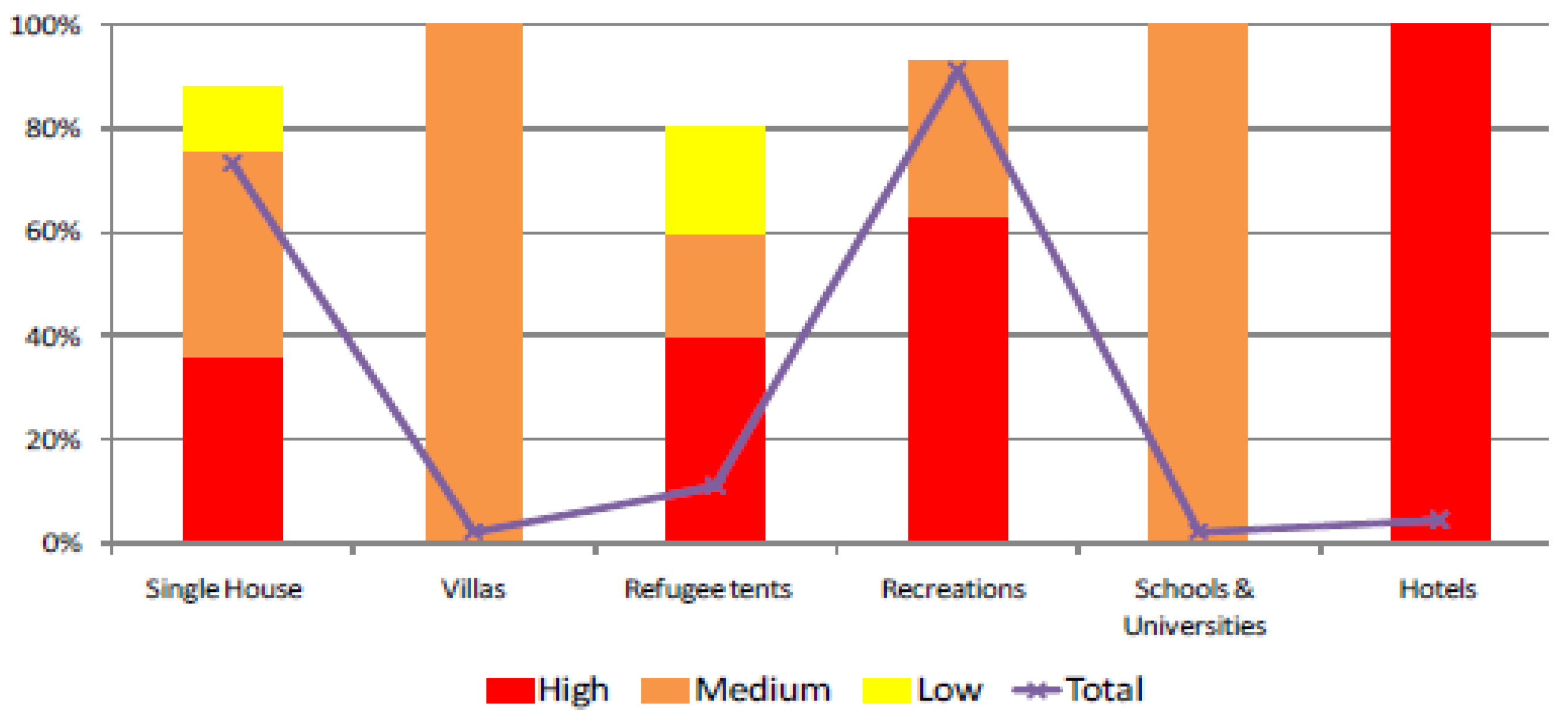
| Artificial Surfaces | Recreation | - | 0.01 | 0.02 | 0.05 | +0.23 | +0.06 | +0.4 | 0.05 | 0.0025 |
| Low Density Urban Fabric | 0.05 | 0.05 | 0.19 | 0.26 | +0.02 | +2.27 | +1.07 | 0.21 | 0.0105 | |
| Medium Density Urban Fabric | - | - | - | 0.000032 | 0 | 0 | +0.0005 | 0.000032 | 0.0000016 | |
| Urban Sprawl on Clear Wooded Land | - | 0.02 | 0.04 | 0.035 | +0.30 | +0.26 | 0 | 0.035 | 0.00175 | |
| Urban Sprawl on Field Crops | - | 0.01 | 0.02 | 0.04 | +0.23 | +0.06 | +0.33 | 0.04 | 0.002 | |
| Urban Sprawl on Permanent Crops | - | - | 0.008 | 0.06 | 0 | +0.14 | +0.83 | 0.06 | 0.003 | |
| Tourist Resort | - | 0.04 | 0.06 | 0.02 | +0.56 | +0.41 | −0.69 | 0.02 | 0.001 | |
| Total | +0.415 | |||||||||
| Flood Hazard Level | |||
|---|---|---|---|
| LU/LC 2018 | Low | Moderate | High |
| Unproductive areas | X | X | X |
| Diverse Equipment | X | X | |
| Mineral Extraction Site | X | X | |
| Clear-other types of Broadleaved trees | X | X | X |
| Clear Juniper | X | X | |
| Clear Mixed Wooded Lands | X | X | X |
| Clear Oaks | X | X | X |
| Scrubland | X | X | |
| Scrubland with Some Dispersed Bigger Trees | X | X | |
| Medium density grasslands | X | X | X |
| Clear Grasslands | X | X | X |
| Field Crops in Medium to Large Terrace | X | X | |
| Field Crops in Small Fields/Terrace | X | X | X |
| Fruit Trees | X | X | X |
| Olives | X | X | X |
| Protected Agriculture | X | X | X |
| Recreation | X | X | |
| Hill Lake | X | X | |
| Lake | X | ||
| Low Density Urban Fabric | X | X | X |
| Medium Density Urban Fabric | X | ||
| Urban Sprawl on Clear Wooded Land | X | X | X |
| Urban Sprawl on Field Crops | X | X | X |
| Urban Sprawl on Permanent Crops | X | X | X |
| Tourist Resort | X | X | X |
| Industry | X | ||
Publisher’s Note: MDPI stays neutral with regard to jurisdictional claims in published maps and institutional affiliations. |
© 2022 by the authors. Licensee MDPI, Basel, Switzerland. This article is an open access article distributed under the terms and conditions of the Creative Commons Attribution (CC BY) license (https://creativecommons.org/licenses/by/4.0/).
Share and Cite
Der Sarkissian, R.; Al Sayah, M.J.; Abdallah, C.; Zaninetti, J.-M.; Nedjai, R. Land Use Planning to Reduce Flood Risk: Opportunities, Challenges and Uncertainties in Developing Countries. Sensors 2022, 22, 6957. https://doi.org/10.3390/s22186957
Der Sarkissian R, Al Sayah MJ, Abdallah C, Zaninetti J-M, Nedjai R. Land Use Planning to Reduce Flood Risk: Opportunities, Challenges and Uncertainties in Developing Countries. Sensors. 2022; 22(18):6957. https://doi.org/10.3390/s22186957
Chicago/Turabian StyleDer Sarkissian, Rita, Mario J. Al Sayah, Chadi Abdallah, Jean-Marc Zaninetti, and Rachid Nedjai. 2022. "Land Use Planning to Reduce Flood Risk: Opportunities, Challenges and Uncertainties in Developing Countries" Sensors 22, no. 18: 6957. https://doi.org/10.3390/s22186957
APA StyleDer Sarkissian, R., Al Sayah, M. J., Abdallah, C., Zaninetti, J.-M., & Nedjai, R. (2022). Land Use Planning to Reduce Flood Risk: Opportunities, Challenges and Uncertainties in Developing Countries. Sensors, 22(18), 6957. https://doi.org/10.3390/s22186957