
Algorithms for Delivery of Data by Drones in an Isolated Area Divided into Squares


Abstract
:1. Introduction
- The proposed drone network is independent of the Internet, and is of the DTN type.
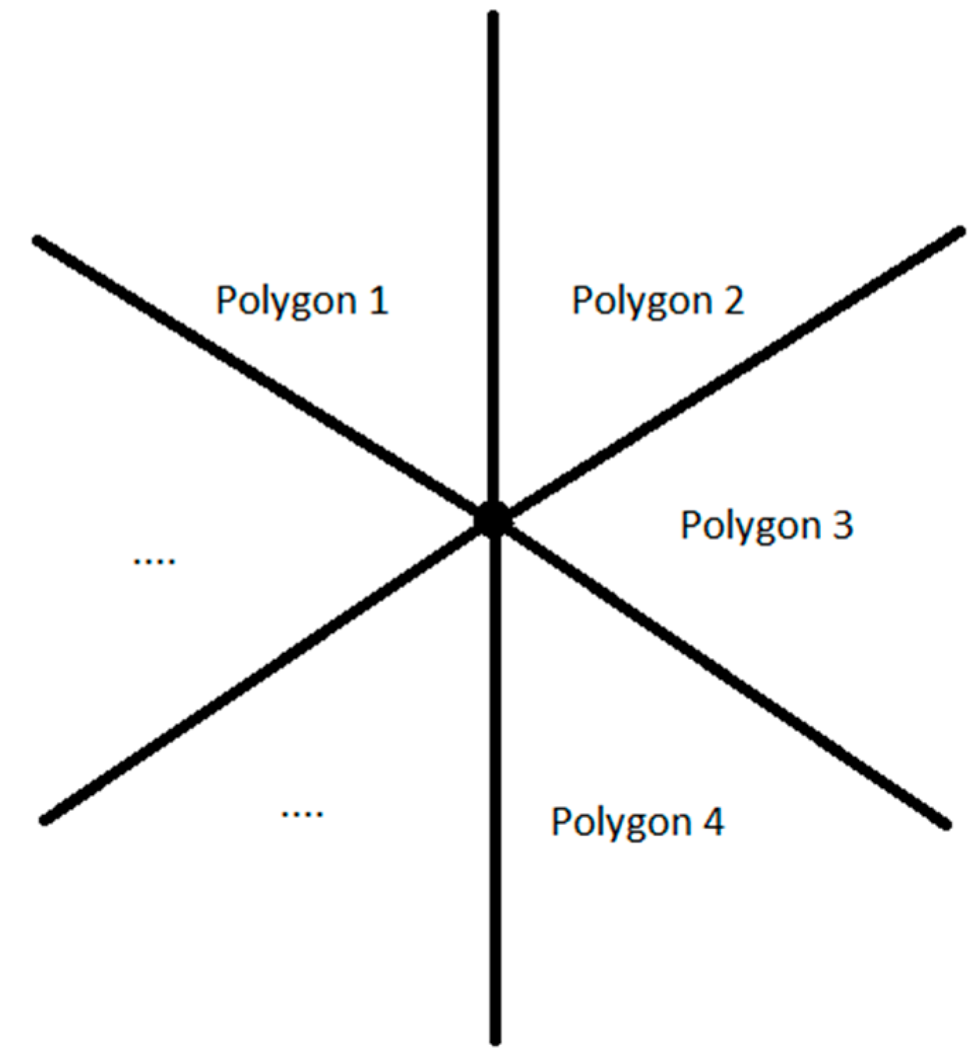
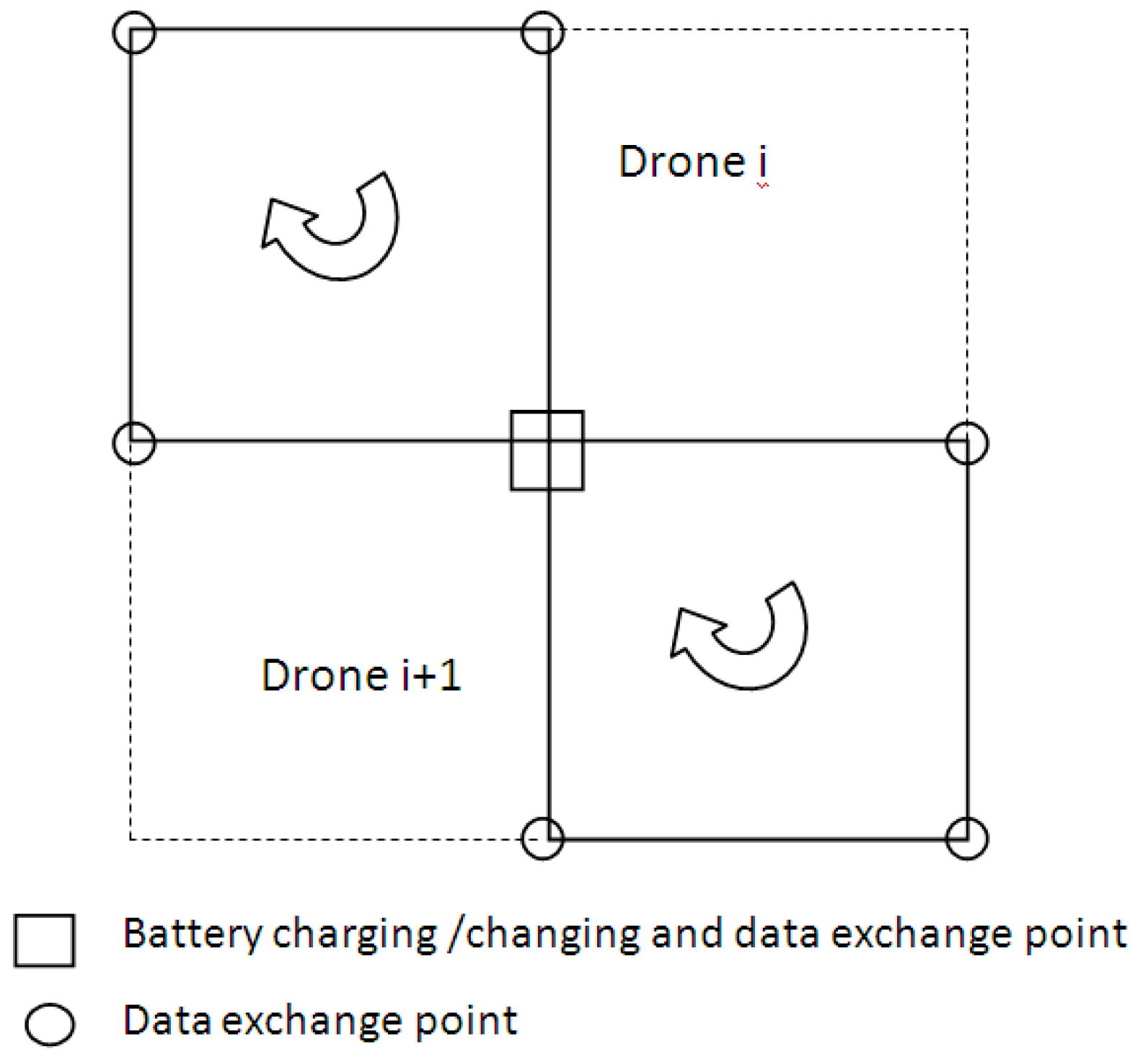
- A topological map as a collection of regular polygons (squares) was proposed.
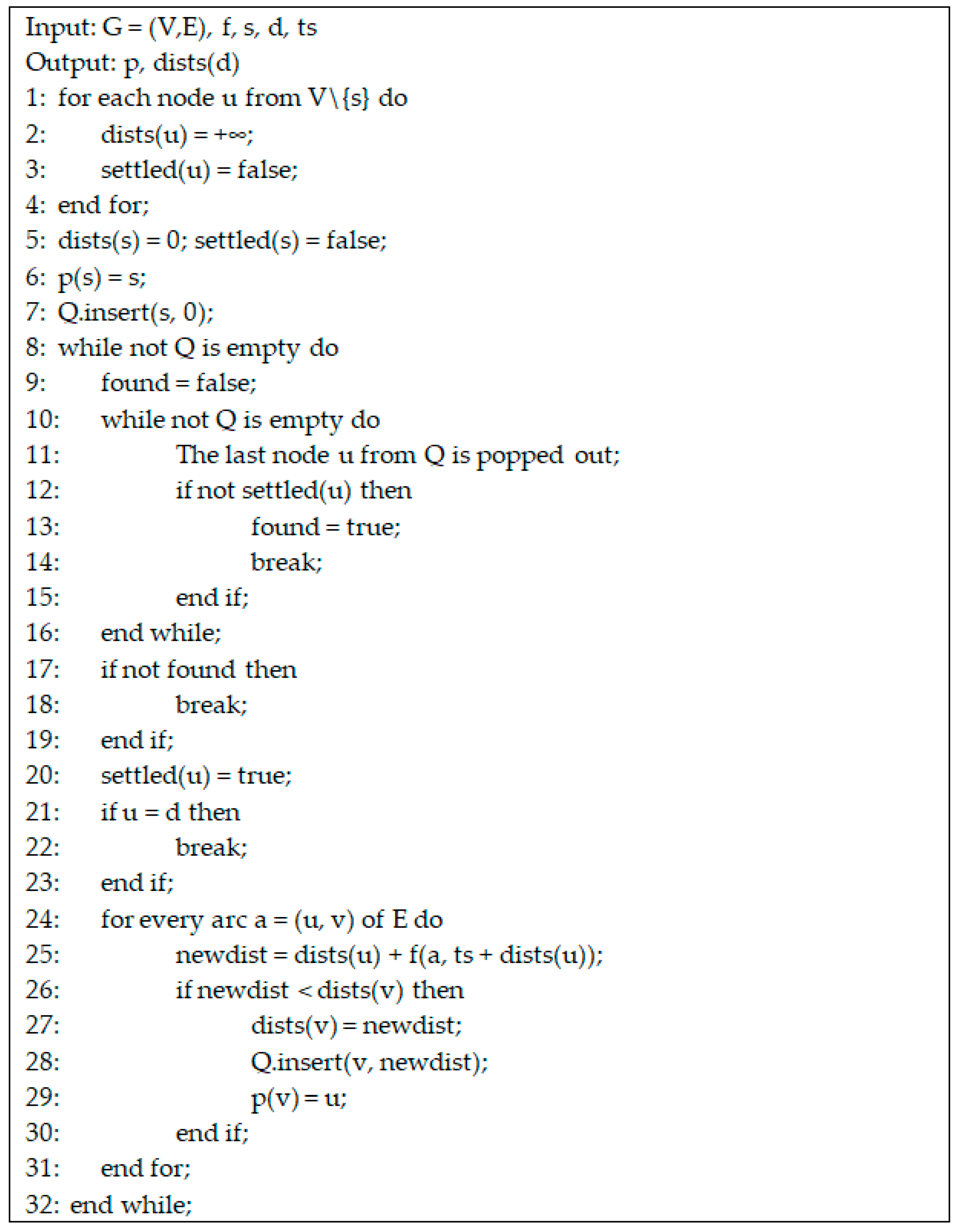
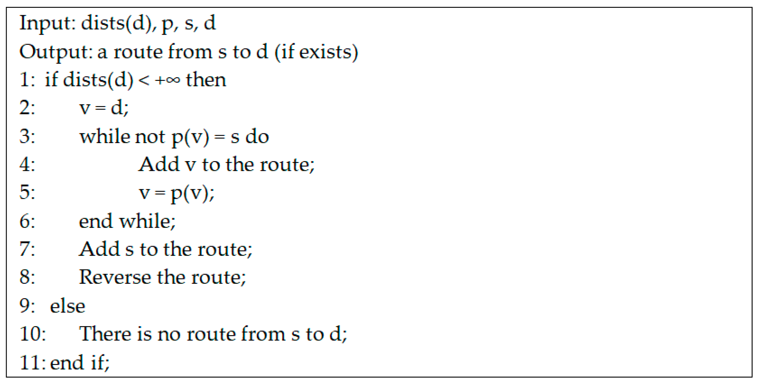
- A time-dependent variant of Dijkstra’s algorithm, which determines the fastest route by taking into account the time when the message reaches the node and the time allocated for data transfer, was developed for the proposed network.
- Five classical algorithms for DTN networks were adapted and tested for the proposed network.
- Simulations based on flight tests were performed to analyze the efficiency of the data transmission. The results obtained by the single-copy and multiple-copy algorithms were compared, in the case of buffer limited capacity.
- Practical application of this work is to facilitate the transmission of information in regions quarantined due to an infectious outbreak, such as COVID-19 pandemic, in regions with technical damage due to a disaster, and in non-urbanized areas without electricity access or communication infrastructure.
2. Materials and Methods
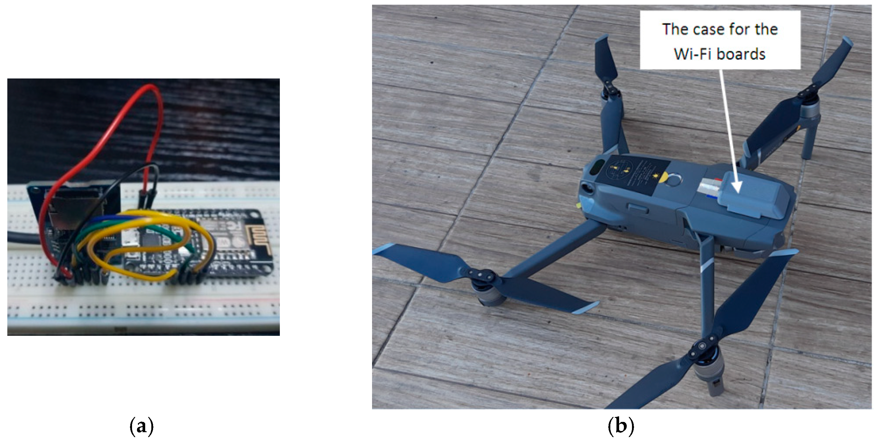
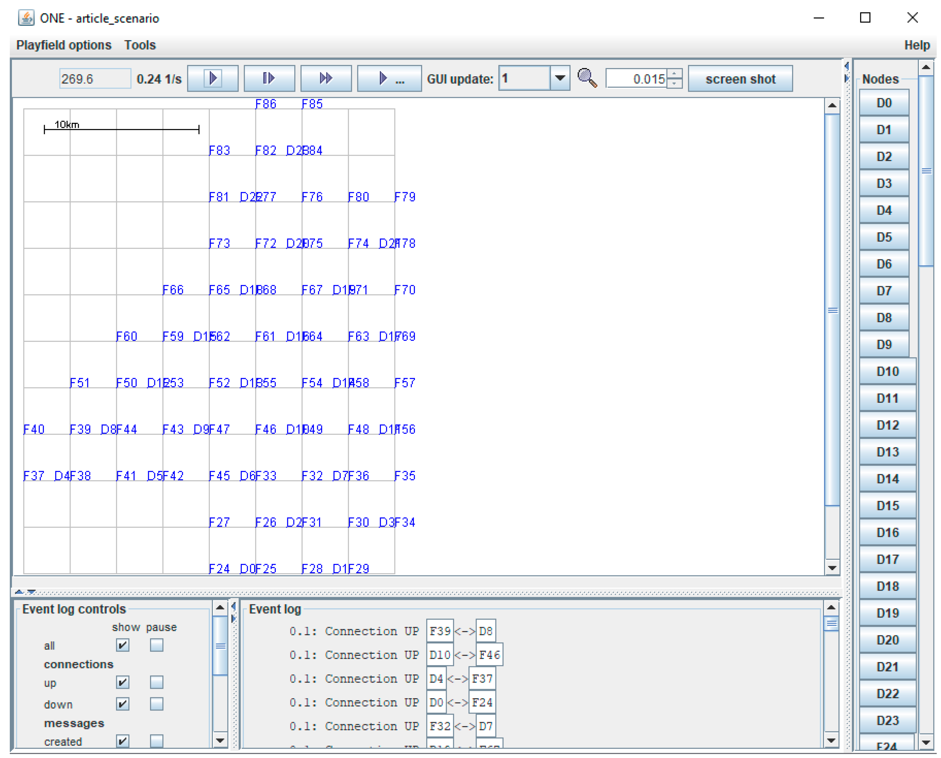
2.1. Drone Network Architecture and Communication
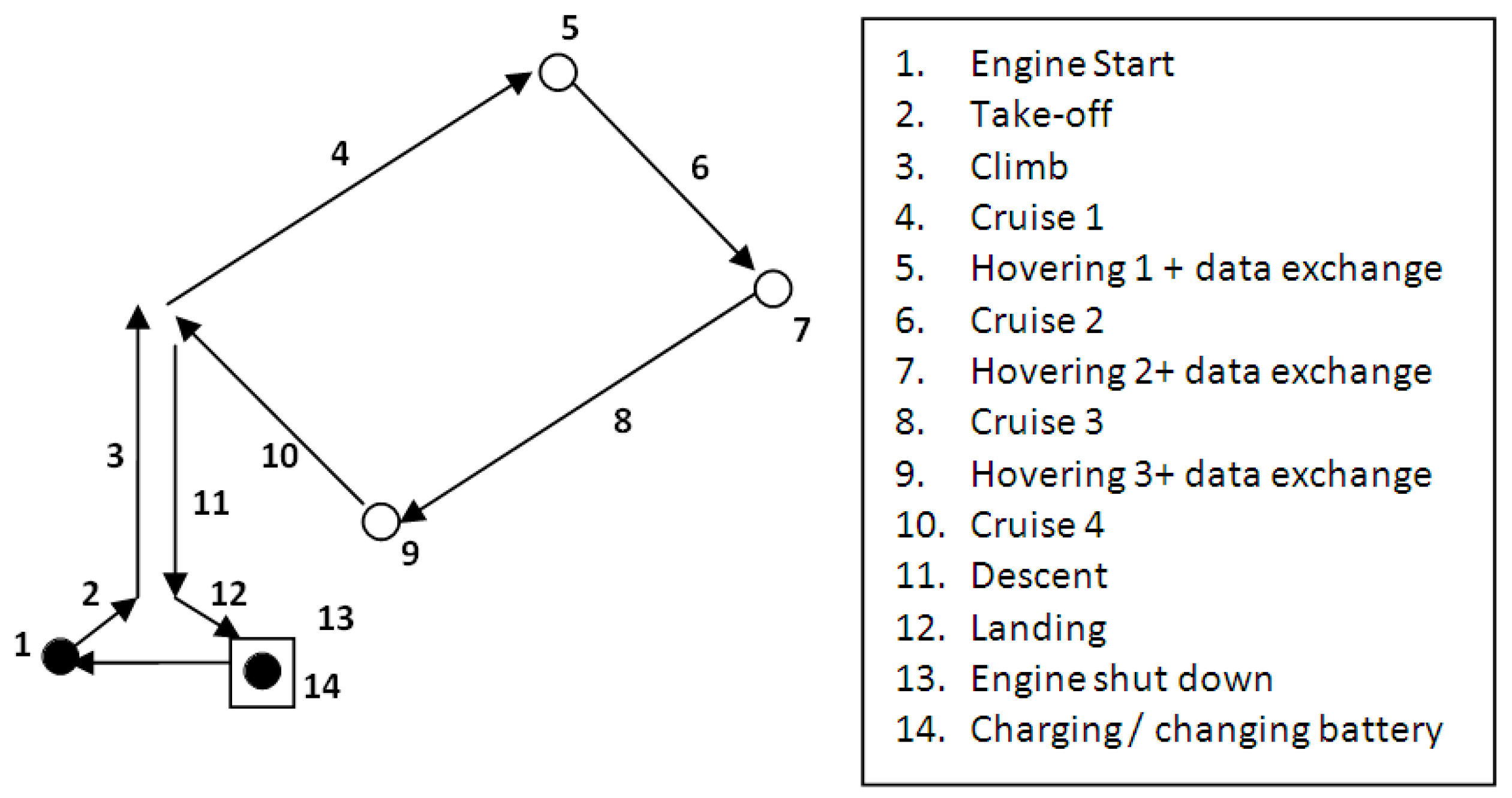
2.2. Algorithms and Protocols for Delivery of Data Using Drones
3. Simulation Results and Discussion
4. Conclusions and Future Work
Author Contributions
Funding
Institutional Review Board Statement
Informed Consent Statement
Data Availability Statement
Acknowledgments
Conflicts of Interest
References
- Alessi, N.; Caini, C.; de Cola, T.; Martin, S.; Mayer, J.P. DTN Performance in Complex Deep-Space Networks. In Proceedings of the ASMS 2018, Berlin, Germany, 10–12 September 2018; pp. 1–7. [Google Scholar]
- Cerf, V.; Hooke, A.; Torgerson, L.; Durst, R.; Scott, K.; Fall, K.; Weiss, H. Delay-Tolerant Networking Architecture. Internet RFC 4838. 2007. Available online: www.rfc-editor.org/rfc/rfc4838.txt (accessed on 25 June 2020).
- Bertolazzi, M.; Caini, C. Mars to Earth Data Downloading: A Directory Synchronization Approach. Future Internet 2019, 11, 173. [Google Scholar] [CrossRef] [Green Version]
- Tornell, S.M.; Calafate, C.T.; Cano, J.C.; Manzoni, P. DTN Protocols for Vehicular Networks: An Application Oriented Overview. IEEE Commun. Surv. Tutor. 2015, 17, 868–887. [Google Scholar] [CrossRef] [Green Version]
- Zguira, Y.; Rivano, H.; Meddeb, A. Internet of Bikes: A DTN Protocol with Data Aggregation for Urban Data Collection. Sensors 2018, 18, 2819. [Google Scholar] [CrossRef] [PubMed] [Green Version]
- Urquiza-Aguiar, L.; Tripp-Barba, C.; Aguilar Igartua, M. A Geographical Heuristic Routing Protocol for VANETs. Sensors 2016, 16, 1567. [Google Scholar] [CrossRef] [Green Version]
- Warthman, F. Delay-and Disruption-Tolerant Networks (DTNs); Version 3.2.; Warthman Associates: Palo Alto, CA, USA, 2015. [Google Scholar]
- Wong, K.S.; Wan, T.C. Current State of Multicast Routing Protocols for Disruption Tolerant Networks: Survey and Open Issues. Electronics 2019, 8, 162. [Google Scholar] [CrossRef] [Green Version]
- Tikhonov, E.; Schneps-Schneppe, D.; Namio, D. Delay Tolerant Network Potential in a Railway Network. In Proceedings of the 2020 IEEE 26th Conference of Open Innovations Association (FRUCT), Yaroslavl, Russia, 20–24 April 2020; pp. 438–448. [Google Scholar]
- Natkaniec, M. Ad hoc mobile wireless networks: Principles, protocols, and applications. IEEE Commun. Mag. 2009, 47, 12–14. [Google Scholar] [CrossRef]
- Picu, A.; Spyropoulos, T. Forecasting DTN performance under heterogeneous mobility: The case of limited replication. In Proceedings of the 9th Annual IEEE Communications Society Conference on Sensor, Mesh and Ad Hoc Communications and Networks (SECON), Seoul, Korea, 18–21 June 2012; pp. 569–577. [Google Scholar]
- Mengjuan, L.; Yan, Y.; Zhiguang, Q. A Survey of Routing Protocols and Simulations in Delay-Tolerant Networks, Wireless Algorithms, Systems, and Applications, Vol. 6843 of Lecture Notes in Computer Science; Springer: Berlin/Heidelberg, Germany, 2011; pp. 243–253. [Google Scholar]
- Nikam, D.D.; Singh, H.P.; Kushwah, R. Conditional Shortest Path Routing in Delay Tolerant Networks. Int. J. Adv. Res. Sci. Eng. 2017, 6, 1. [Google Scholar]
- Jain, S.; Fall, K.; Patra, R. Routing in a Delay Tolerant Network. In Proceedings of the 2004 conference on Applications, Technologies, Architectures, and Protocols for Computer Communications, Portland, OR, USA, 30 August–3 September 2004; Volume 34, pp. 145–158. [Google Scholar] [CrossRef]
- Kawakib, K.A.; Mohd, H.O.; Suhaidi, H. Survey and Comparison of Operating Concept for Routing Protocols in DTN. J. Comput. Sci. 2016, 12, 141–152. [Google Scholar]
- Spyropoulos, T.; Psounis, K.; Raghavendra, C.S. Single-copy routing in intermittently connected mobile networks. In Proceedings of the 1st Annual IEEE Communications Society Conference on Sensor and Ad Hoc Communications and Networks, Santa Clara, CA, USA, 4–7 October 2004; pp. 235–244. [Google Scholar]
- Vahdat, A.; Becker, D. Epidemic Routing for Partially-Connected Ad Hoc Networks; Technical Report CS-2000–06; Duke University: Duhram, NC, USA, 2000. [Google Scholar]
- Raghavendra, C.; Spyropoulos, T.; Psounis, K. Spray and Wait: An Efficient Routing Scheme for Intermittently Connected Mobile Networks. In Proceedings of the ACM SIGCOMM Workshop on Delay-Tolerant Networking (WDTN), Philadelphia, PA, USA, 26 August 2005; pp. 252–259. [Google Scholar]
- Lindgren, A.; Doria, A.; Schelen, O. Probabilistic routing in intermittently connected networks. ACM SIGMOBILE Mob. Comput. Commun. 2003, 7, 19–20. [Google Scholar] [CrossRef]
- Burgess, J.; Gallagher, B.; Jensen, D.; Levine, B.N. MaxProp: Routing for Vehicle-Based Disruption-Tolerant Networks. In Proceedings of the IEEE INFOCOM 2006, Barcelona, Spain, 23–29 April 2006. [Google Scholar]
- Nanau, C.Ş. Maximum flow in buffer-limited delay tolerant networks. The static approach. Bull. Transilv. Univ. Bras. Ser. III Math. Inform. Phys. 2020, 13, 363–372. [Google Scholar] [CrossRef]
- Schiopu, C.; Ciurea, E. Maximum flows in planar dynamic networks with lower bounds. Fundam. Inform. 2018, 163, 189–204. [Google Scholar] [CrossRef]
- Spaho, E. Energy consumption analysis of different routing protocols in a Delay Tolerant Network. J. Ambient Intell. Humaniz. Comput. 2020, 11, 3833–3839. [Google Scholar] [CrossRef]
- Jigang, W.; Jin, S.; Ji, H.; Srikanthan, T. Algorithm for time-dependent shortest safe path on transportation networks. Procedia Comput. Sci. 2011, 4, 958–966. [Google Scholar] [CrossRef] [Green Version]
- Mao, Y.; Zhou, C.; Ling, Y.; Lloret, J. An Optimized Probabilistic Delay Tolerant Network (DTN) Routing Protocol Based on Scheduling Mechanism for Internet of Things (IoT). Sensors 2019, 19, 243. [Google Scholar] [CrossRef] [Green Version]
- Chițonu, G.C.; Rolfsen, C.N.; Deaconu, O. Accessibility to Transylvania’s cultural heritage through BIM-Heritage and community involvement. IOP Conf. Ser. Mater. Sci. Eng. 2020, 789, 012010. [Google Scholar] [CrossRef]
- Hassanalian, M.; Abdelkefi, A. Classifications, applications, and design challenges of drones: A review. Prog. Aerosp. Sci. 2017, 91, 99–131. [Google Scholar] [CrossRef]
- Iranmanesh, S.; Raad, R. A Novel Data Forwarding Strategy for a Drone Delay Tolerant Network with Range Extension. Electronics 2019, 8, 659. [Google Scholar] [CrossRef] [Green Version]
- Kellermann, R.; Biehle, T.; Fischer, L. Drones for parcel and passenger transportation: A literature review. Transp. Res. Interdiscip. Perspect. 2020, 4, 100088. [Google Scholar] [CrossRef]
- Rango, F.; De Potrino, G.; Tropea, M.; Santamaria, A.F.; Fazio, P. Scalable and ligthway bio-inspired coordination protocol for FANET in precision agriculture applications. Comput. Electr. Eng. 2019, 74, 305–318. [Google Scholar] [CrossRef]
- Hu, T.; Wang, Y.; Ma, B.; Zhang, J. Orbit Angular Momentum MIMO with Mode Selection for UAV-Assisted A2G Networks. Sensors 2020, 20, 2289. [Google Scholar] [CrossRef] [PubMed] [Green Version]
- Nazib, R.A.; Moh, S. Routing Protocols for Unmanned Aerial Vehicle-Aided Vehicular Ad Hoc Networks: A Survey. IEEE Access 2020, 8, 77535–77560. [Google Scholar] [CrossRef]
- Lee, T.R.; Buban, M.; Dumas, E.; Baker, C.B. On the Use of Rotary-Wing Aircraft to Sample Near-Surface Thermodynamic Fields: Results from Recent Field Campaigns. Sensors 2019, 19, 10. [Google Scholar] [CrossRef] [PubMed] [Green Version]
- Alaoui-Sosse, S.; Durand, P.; Medina, P.; Pastor, P.; Lothon, M.; Cernov, I. OVLI-TA: An Unmanned Aerial System for Measuring Profiles and Turbulence in the Atmospheric Boundary Layer. Sensors 2019, 19, 581. [Google Scholar] [CrossRef] [Green Version]
- Nolan, P.J.; Pinto, J.; González-Rocha, J.; Jensen, A.; Vezzi, C.N.; Bailey, S.C.C.; De Boer, G.; Diehl, C.; Laurence, R., III; Powers, C.W.; et al. Coordinated Unmanned Aircraft System (UAS) and Ground-Based Weather Measurements to Predict Lagrangian Coherent Structures (LCSs). Sensors 2018, 18, 4448. [Google Scholar] [CrossRef] [Green Version]
- Da Rosa, R.; Aurelio Wehrmeister, M.; Brito, T.; Lima, J.L.; Pereira, A.I.P.N. Honeycomb Map: A Bioinspired Topological Map for Indoor Search and Rescue Unmanned Aerial Vehicles. Sensors 2020, 20, 907. [Google Scholar] [CrossRef] [PubMed] [Green Version]
- Yang, P.; Tang, K.; Lozano, J.A.; Cao, X. Path planning for single unmanned aerial vehicle by separately evolving waypoints. IEEE Trans. Robot. 2015, 31, 1130–1146. [Google Scholar] [CrossRef] [Green Version]
- Zhang, S.; Zhang, H.; Di, B.; Song, L. Cellular controlled cooperative unmanned aerial vehicle networks with sense-and-send protocol. IEEE Int. Things J. 2018, 6, 1–13. [Google Scholar]
- Kima, S.J.; Lima, G.J.; Chob, J. Drone flight scheduling under uncertainty on battery duration and air temperature. Comput. Ind. Eng. 2018, 1171, 291–302. [Google Scholar] [CrossRef]
- Cabreira, T.M.; Brisolara, L.B.; Ferreira, P.R., Jr. Survey on Coverage Path Planning with Unmanned Aerial Vehicles. Drones 2019, 3, 4. [Google Scholar] [CrossRef] [Green Version]
- Udroiu, R.; Deaconu, A.M.; Nanau, C.-Ş. Data Delivery in a Disaster or Quarantined Area Divided into Triangles Using DTN-Based Algorithms for Unmanned Aerial Vehicles. Sensors 2021, 21, 3572. [Google Scholar] [CrossRef] [PubMed]
- Udroiu, R.; Blaj, M. Conceptual design of a VTOL remotely piloted aircraft for emergency missions. Sci. Res. Educ. Air Force 2016, 18, 207–214. [Google Scholar] [CrossRef]
- DJI. DJI Mavic 2 Pro Specification. Available online: www.dji.com (accessed on 15 June 2020).
- Herath, H.M.C.W.B.; Herath, H.M.S.; Sumangala, S.W.; de Silva, O.; Chathuranga, D.; Lalitharatne, T.D. Design and Development of an Automated Battery Swapping and Charging Station for Multirotor Aerial Vehicles. In Proceedings of the 17th International Conference on Control, Automation and Systems (ICCAS 2017), Jeju, Korea, 18–21 October 2017; pp. 356–361. [Google Scholar]
- Lee, D.; Zhou, J.; Lin, W.T. Autonomous battery swapping system for quadcopter. In Proceedings of the International Conference on Unmanned Aircraft Systems (ICUAS), Denver, CO, USA, 9–12 June 2015; pp. 118–124. [Google Scholar]
- High Power Drone Charging Pad and Infrastructure. Available online: https://skycharge.de/ (accessed on 26 October 2020).
- Costea, I.M.; Plesca, V. Automatic battery charging system for electric powered drones. In Proceedings of the 2018 IEEE 24th International Symposium for Design and Technology in Electronic Packaging (SIITME), Iasi, Romania, 25–28 October 2018; pp. 377–381. [Google Scholar]
- Mostafa, T.M.; Muharam, A.; Hattori, R. Wireless Battery Charging System for Drones via Capacitive Power Transfer. In Proceedings of the IEEE PELS Workshop on Emerging Technologies: Wireless Power Transfer (WoW), Chongqing, China, 20–22 May 2017. [Google Scholar] [CrossRef]
- Boukoberine, M.N.; Zhou, Z.; Benbouzid, M. Power Supply Architectures for Drones-A Review. In Proceedings of the 45th Annual Conference of the IEEE Industrial Electronics Society (IECON 2019), Lisbon, Portugal, 14–17 October 2019; pp. 5826–5831. [Google Scholar]
- Lin, C.-F.; Lin, T.-J.; Liao, W.-S.; Lan, H.; Lin, J.-Y.; Chiu, C.-H.; Danner, A. Solar Power Can Substantially Prolong Maximum Achievable Airtime of Quadcopter Drones. Adv. Sci. 2020, 7, 20. [Google Scholar] [CrossRef]
- Achtelik, M.C.; Stumpf, J.; Gurdan, D.; Doth, K.-M. Design of a flexible high performance quadcopter platform breaking the MAV endurance record with laser power beaming. In Proceedings of the IEEE/RSJ International Conference on Intelligent Robots and Systems, San Francisco, CA, USA, 25–30 September 2011. [Google Scholar] [CrossRef]
- Taddia, Y.; Corbau, C.; Zambello, E.; Pellegrinelli, A. UAVs for Structure-From-Motion Coastal Monitoring: A Case Study to Assess the Evolution of Embryo Dunes over a Two-Year Time Frame in the Po River Delta, Italy. Sensors 2019, 19, 1717. [Google Scholar] [CrossRef] [Green Version]
- WiFi NodeMCU ESP8266. Available online: www.espressif.com/en/products/socs/esp8266 (accessed on 25 June 2020).
- Nănău, C.Ş. MaxDelivery: A new approach to a DTN Buffer Management. In Proceedings of the 21ST IEEE International Symposium on a World of Wireless, Mobile and Multimedia Networks (IEEE WOWMOM 2020), Cork, Ireland, 31 August–3 September 2020; pp. 60–61. [Google Scholar]
- Lewis, R. Algorithms for Finding Shortest Paths in Networks with Vertex Transfer Penalties. Algorithms 2020, 13, 269. [Google Scholar] [CrossRef]
- Wang, Y.; Yuan, Y.; Ma, Y.; Wang, G. Time-Dependent Graphs: Definitions, Applications, and Algorithms. Data Sci. Eng. 2019, 4, 352–366. [Google Scholar] [CrossRef] [Green Version]


| Parameter | Value |
|---|---|
| Max ascent/descent speed | 4 m/s; 3 m/s |
| Max flight time (no wind) | 31 min (at a consistent 25 km/h) |
| Max flight distance (no wind) | 18 km (at a consistent 50 km/h) |
| Drone battery | 3850 mAh, 1800 mA, 3.83 V |
| Mission Phase | Mean Flight Time | Standard Deviation |
|---|---|---|
| Take off + climb (30 m) | 8.24 s | 0.193 |
| Cruise segment (3000 m) | 232 s | 0.187 |
| Descent + landing (30 m) | 12.12 s | 0.085 |
| Transfer data (3 points) | 120 s | - |
| Total flight on square cell | 1308 s | 0.651 |
| Parameter | Value |
|---|---|
| ESP8266 chip | 26 MHz, 4 MB flash, 160 KB RAM |
| Dimensions (L × W) | 48 mm × 25 mm |
| Operating temperature | −40 °C to + 125 °C |
| Weight | 8 g |
| Parameter | Value |
|---|---|
| Number of drones for cruise | 24 |
| Number of fixed transfer points | 63 |
| Number of charging/ changing battery points | 12 |
| Average cruise speed of a drone | 46.55 km/h (12.93 m/s) |
| Flight height of drones | 30 m |
| Operating time of the drone in one day | 11 h |
| Data transmission speed | 2 Mbps |
| Drone buffer space | 2 Gb |
| Message size | 500 kb–1 Mb |
| Message time to live | 10 h |
| Source and destination of messages | any station |
| No. of route simulations | 1000 |
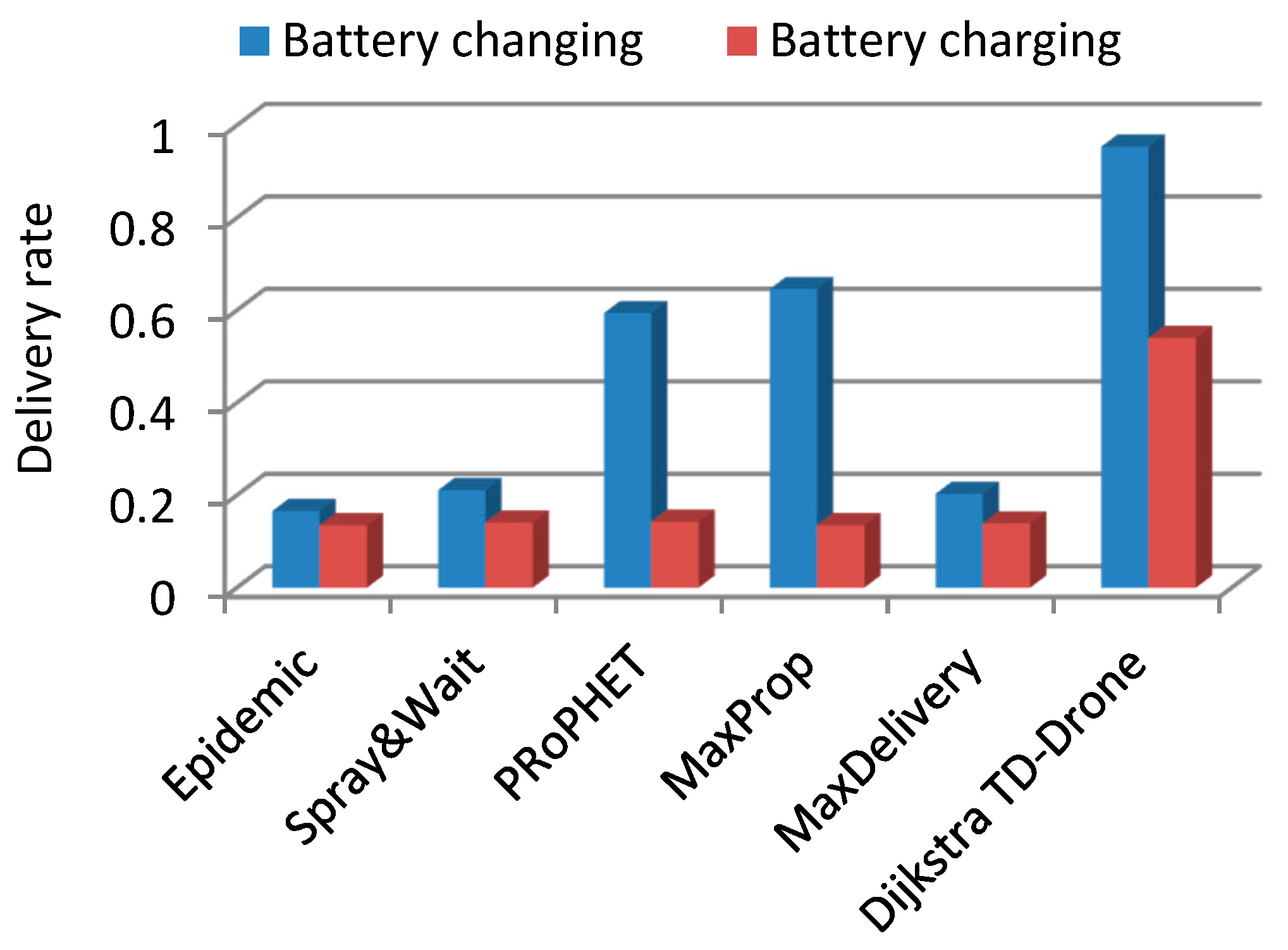
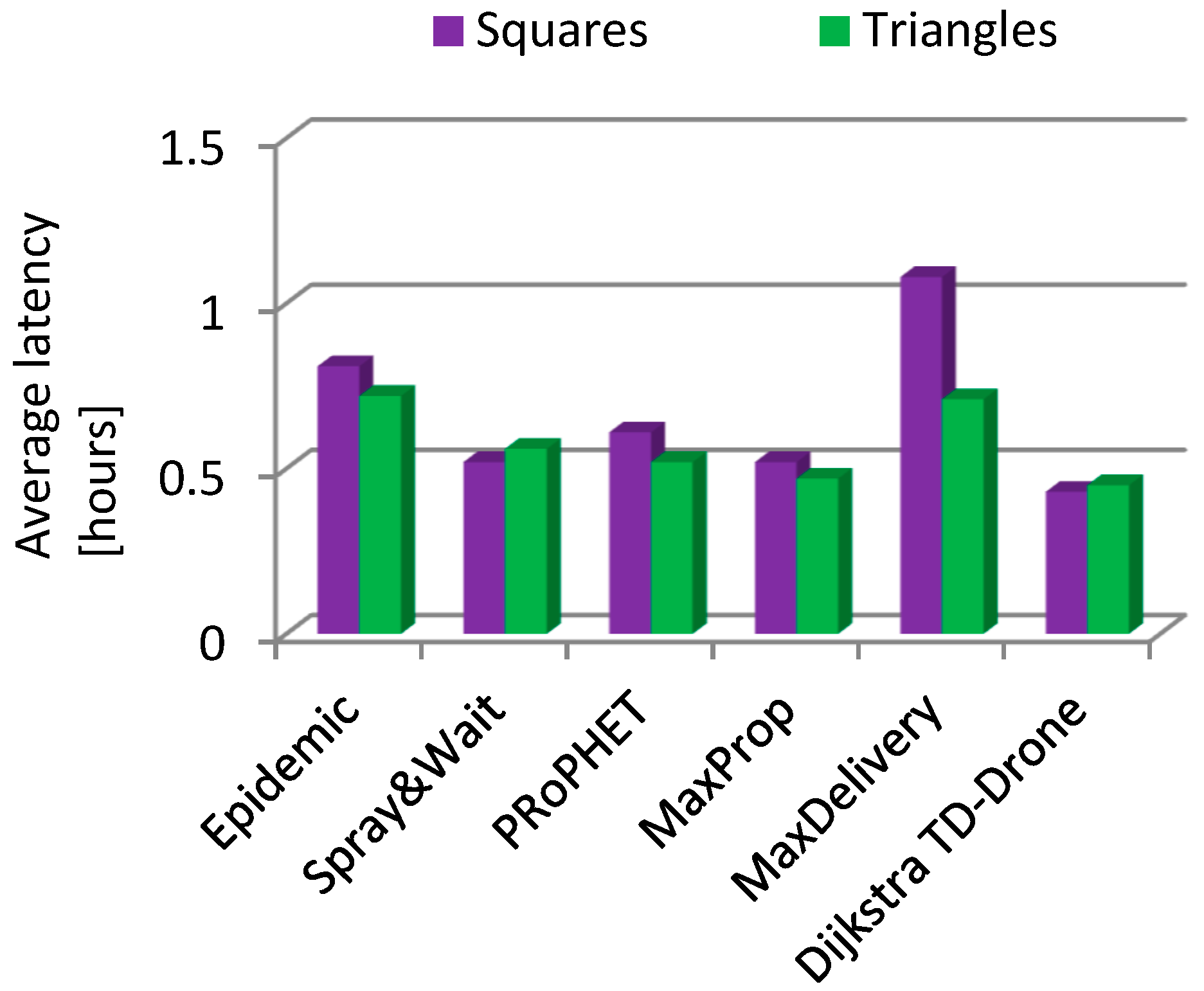
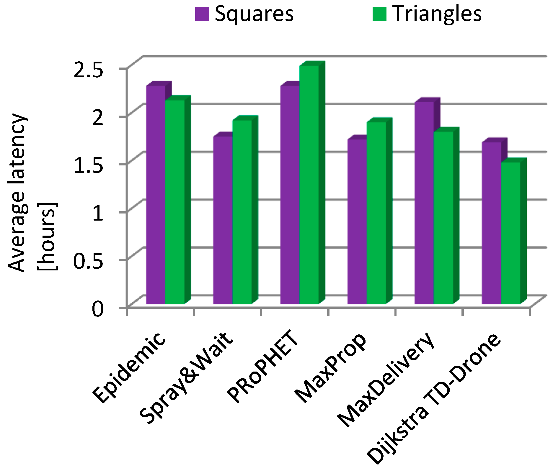
| Algorithm | Delivery Rate | Latency (hours) | ||||||
|---|---|---|---|---|---|---|---|---|
| Battery Changing | Battery Charging | Battery Changing | Battery Charging | |||||
| Squares | Triangular | Squares | Triangular | Squares | Triangular | Squares | Triangular | |
| Epidemic | 0.166 | 0.209 | 0.135 | 0.146 | 0.81 | 0.72 | 2.28 | 2.13 |
| Spray and Wait | 0.211 | 0.179 | 0.141 | 0.156 | 0.52 | 0.56 | 1.75 | 1.92 |
| PRoPHET | 0.594 | 0.762 | 0.143 | 0.319 | 0.61 | 0.52 | 2.28 | 2.49 |
| MaxProp | 0.646 | 0.743 | 0.135 | 0.261 | 0.52 | 0.47 | 1.72 | 1.90 |
| MaxDelivery | 0.203 | 0.271 | 0.139 | 0.160 | 1.08 | 0.71 | 2.11 | 1.80 |
| TD-Drone Dijkstra | 0.954 | 0.973 | 0.540 | 0.664 | 0.43 | 0.45 | 1.69 | 1.48 |
Publisher’s Note: MDPI stays neutral with regard to jurisdictional claims in published maps and institutional affiliations. |
© 2021 by the authors. Licensee MDPI, Basel, Switzerland. This article is an open access article distributed under the terms and conditions of the Creative Commons Attribution (CC BY) license (https://creativecommons.org/licenses/by/4.0/).
Share and Cite
Deaconu, A.M.; Udroiu, R.; Nanau, C.-Ş. Algorithms for Delivery of Data by Drones in an Isolated Area Divided into Squares. Sensors 2021, 21, 5472. https://doi.org/10.3390/s21165472
Deaconu AM, Udroiu R, Nanau C-Ş. Algorithms for Delivery of Data by Drones in an Isolated Area Divided into Squares. Sensors. 2021; 21(16):5472. https://doi.org/10.3390/s21165472
Chicago/Turabian StyleDeaconu, Adrian Marius, Razvan Udroiu, and Corina-Ştefania Nanau. 2021. "Algorithms for Delivery of Data by Drones in an Isolated Area Divided into Squares" Sensors 21, no. 16: 5472. https://doi.org/10.3390/s21165472
APA StyleDeaconu, A. M., Udroiu, R., & Nanau, C.-Ş. (2021). Algorithms for Delivery of Data by Drones in an Isolated Area Divided into Squares. Sensors, 21(16), 5472. https://doi.org/10.3390/s21165472