Glacier Surface Motion Estimation from SAR Intensity Images Based on Subpixel Gradient Correlation
Abstract
1. Introduction
- An improved robust frequency-based image correlation method, which combines complex edge maps and local upsampling in the frequency domain for subpixel translation estimation, is introduced and integrated into a workflow of glacier surface motion estimation using SAR intensity images.
- The reliability and feasibility of the presented dense motion estimation method based on subpixel gradient correlation is demonstrated by using TSX and Sentinel-1A (S1A) images covering two glacier areas in pole and alpine regions.
2. Background of SAR Image-Based Glacier Motion Estimation
2.1. Interferometric Methods
2.2. Offset Tracking-Based Methods
3. Methodology
3.1. Workflow of Glacier Surface Motion Estimation Using SAR Intensity Images
3.2. Dense Matching Based on Subpixel Gradient Correlation
3.2.1. Gradient Correlation
3.2.2. Local Upsampling in the Frequency Domain
4. Experiments
4.1. Study Area and Dataset
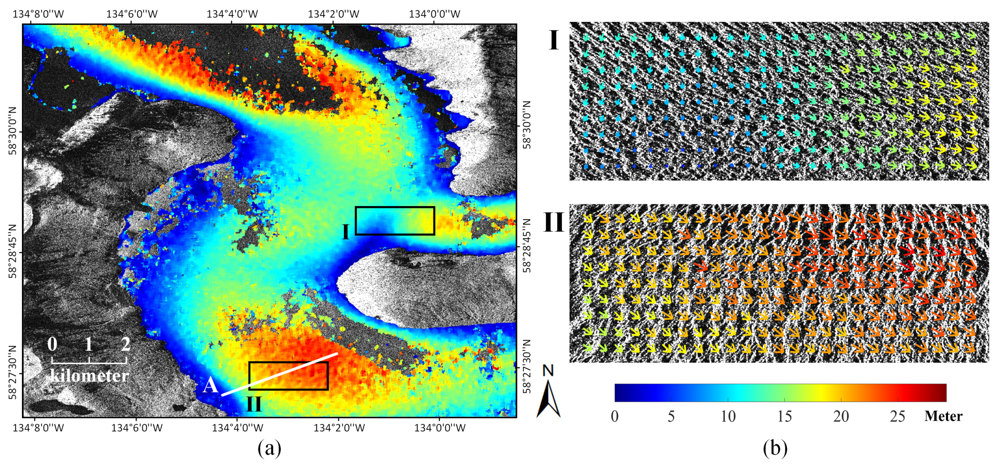
- Taku Glacier is the principal outlet glacier of the Juneau Icefield located in the Coast Mountains of southeast Alaska, as shown in Figure 3a. It is one of the deepest and thickest temperate glaciers known in the world with the maximum thickness measured at 1477 m and the length of the ice shelf approximately reaching 58 km [53]. Taku Glacier is an advancing tidewater glacier characterized by high accumulation rates and very high melt rates at low elevations with a large mass turnover [54]. The behavior of Taku Glacier can greatly reflect the tendency of changes in the Juneau Icefield, possessing significant research value.A pair of TSX images covering the lower Taku Glacier was employed. The image pairs were acquired in strip-map mode from ascending pass direction and have an HH polarization. The imaging dates were 2009.07.11 and 2009.07.22 with one repeat cycle of 11 days apart. The spatial resolution was resampled to 2.09 m × 2.09 m in geometric pre-processing.
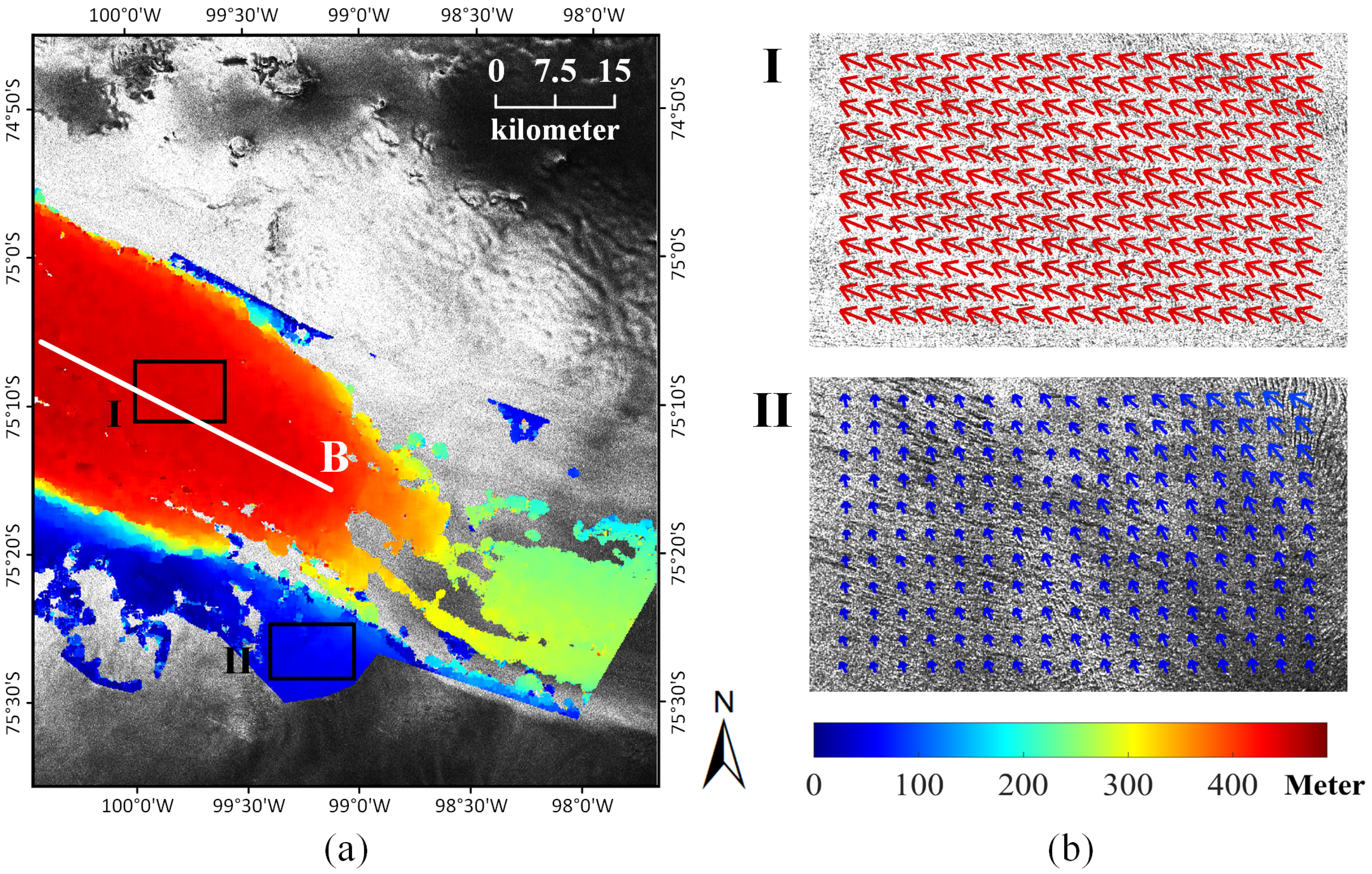
- Pine Island Glacier is one of the largest and fastest glaciers in West Antarctica, as shown in Figure 3b. As one of the major contributors to sea level rise, Pine Island Glacier has gained tremendous attention [55,56]. It has been undergoing thinning and retreat. The ice velocity of Pine Island Glacier accelerated from ∼2.8 km a in 1996 to ∼4 km a in 2012 and continued losing mass because of global warming [57,58].A pair of S1A images covering the main part of Pine Island Glacier was download from the ESA Scientific Data Hub. Level-1 SLC data in interferometric wide swath mode were employed. The image pairs came from 36 -day repeat pass orbits (three repeat cycles), acquired on 17 February 2020 and 24 March 2020. The raw data were pre-processed using SARscape 5.2 software with geocoding of the intensity images to a 20 m × 20 m spatial resolution.
4.2. Experimental Details
5. Results and Discussions
5.1. Experiments with Simulated Image Data
5.2. Experiments with Real Image Data
5.2.1. Motion Estimation of Taku Glacier
5.2.2. Motion Estimation of Pine Island Glacier
5.2.3. Comparison with Other Matching Methods
6. Conclusions
Author Contributions
Funding
Acknowledgments
Conflicts of Interest
References
- Rees, W.G. Remote Sensing of Snow and Ice; CRC Press: Boca Raton, FL, USA, 2005. [Google Scholar]
- Gardner, A.S.; Moholdt, G.; Cogley, J.G.; Wouters, B.; Arendt, A.A.; Wahr, J.; Berthier, E.; Hock, R.; Pfeffer, W.T.; Kaser, G.; et al. A reconciled estimate of glacier contributions to sea level rise: 2003 to 2009. Science 2013, 340, 852–857. [Google Scholar] [CrossRef] [PubMed]
- Schubert, A.; Faes, A.; Kääb, A.; Meier, E. Glacier surface velocity estimation using repeat TerraSAR-X images: Wavelet-vs. correlation-based image matching. ISPRS J. Photogramm. Remote. Sens. 2013, 82, 49–62. [Google Scholar] [CrossRef]
- Paul, F.; Bolch, T.; Kääb, A.; Nagler, T.; Nuth, C.; Scharrer, K.; Shepherd, A.; Strozzi, T.; Ticconi, F.; Bhambri, R.; et al. The glaciers climate change initiative: Methods for creating glacier area, elevation change and velocity products. Remote Sens. Environ. 2015, 162, 408–426. [Google Scholar] [CrossRef]
- Heid, T.; Kääb, A. Evaluation of existing image matching methods for deriving glacier surface displacements globally from optical satellite imagery. Remote Sens. Environ. 2012, 118, 339–355. [Google Scholar] [CrossRef]
- Tong, X.; Liu, S.; Li, R.; Xie, H.; Liu, S.; Qiao, G.; Feng, T.; Tian, Y.; Ye, Z. Multi-track extraction of two-dimensional surface velocity by the combined use of differential and multiple-aperture InSAR in the Amery Ice Shelf, East Antarctica. Remote Sens. Environ. 2018, 204, 122–137. [Google Scholar] [CrossRef]
- Duan, P.; Lai, J.; Kang, J.; Kang, X.; Ghamisi, P.; Li, S. Texture-aware total variation-based removal of sun glint in hyperspectral images. ISPRS J. Photogramm. Remote Sens. 2020, 166, 359–372. [Google Scholar] [CrossRef]
- Fang, L.; Xu, Y.; Yao, W.; Stilla, U. Estimation of glacier surface motion by robust phase correlation and point like features of SAR intensity images. ISPRS J. Photogramm. Remote Sens. 2016, 121, 92–112. [Google Scholar] [CrossRef]
- Kang, J.; Wang, Y.; Zhu, X.X. Multipass SAR Interferometry Based on Total Variation Regularized Robust Low Rank Tensor Decomposition. IEEE Trans. Geosci. Remote Sens. 2020, 58, 5354–5366. [Google Scholar] [CrossRef]
- Gray, L. Using multiple RADARSAT InSAR pairs to estimate a full three-dimensional solution for glacial ice movement. Geophys. Res. Lett. 2011, 38. [Google Scholar] [CrossRef]
- Kang, J.; Wang, Y.; Körner, M.; Zhu, X.X. Robust Object-Based Multipass InSAR Deformation Reconstruction. IEEE Trans. Geosci. Remote Sens. 2017, 55, 4239–4251. [Google Scholar] [CrossRef]
- Cheng, X.; Li, X.; Shao, Y.; Li, Z. DINSAR measurement of glacier motion in Antarctic Grove Mountain. Chin. Sci. Bull. 2007, 52, 358–366. [Google Scholar] [CrossRef]
- Kumar, V.; Venkataramana, G.; Høgda, K.A. Glacier surface velocity estimation using SAR interferometry technique applying ascending and descending passes in Himalayas. Int. J. Appl. Earth Obs. Geoinf. 2011, 13, 545–551. [Google Scholar] [CrossRef]
- Rignot, E.; Jacobs, S.S. Rapid bottom melting widespread near Antarctic ice sheet grounding lines. Science 2002, 296, 2020–2023. [Google Scholar] [CrossRef] [PubMed]
- Hu, J.; Li, Z.W.; Li, J.; Zhang, L.; Ding, X.L.; Zhu, J.J.; Sun, Q. 3-D movement mapping of the alpine glacier in Qinghai-Tibetan Plateau by integrating D-InSAR, MAI and Offset-Tracking: Case study of the Dongkemadi Glacier. Glob. Planet. Chang. 2014, 118, 62–68. [Google Scholar] [CrossRef]
- Bechor, N.B.; Zebker, H.A. Measuring two-dimensional movements using a single InSAR pair. Geophys. Res. Lett. 2006, 33. [Google Scholar] [CrossRef]
- Gourmelen, N.; Kim, S.; Shepherd, A.; Park, J.; Sundal, A.; Björnsson, H.; Pálsson, F. Ice velocity determined using conventional and multiple-aperture InSAR. Earth Planet. Sci. Lett. 2011, 307, 156–160. [Google Scholar] [CrossRef]
- Strozzi, T.; Luckman, A.; Murray, T.; Wegmuller, U.; Werner, C.L. Glacier motion estimation using SAR offset-tracking procedures. IEEE Trans. Geosci. Remote Sens. 2002, 40, 2384–2391. [Google Scholar] [CrossRef]
- Lucchitta, B.K.; Ferguson, H. Antarctica: Measuring glacier velocity from satellite images. Science 1986, 234, 1105–1108. [Google Scholar] [CrossRef]
- Liu, W.; Yamazaki, F. Detection of crustal movement from TerraSAR-X intensity images for the 2011 Tohoku, Japan earthquake. IEEE Geosci. Remote Sens. Lett. 2012, 10, 199–203. [Google Scholar] [CrossRef]
- Korosov, A.A.; Rampal, P. A combination of feature tracking and pattern matching with optimal parametrization for sea ice drift retrieval from SAR data. Remote Sens. 2017, 9, 258. [Google Scholar] [CrossRef]
- Ferretti, A.; Prati, C.; Rocca, F. Permanent scatterers in SAR interferometry. IEEE Trans. Geosci. Remote Sens. 2001, 39, 8–20. [Google Scholar] [CrossRef]
- Sanjuan-Ferrer, M.J.; Hajnsek, I.; Papathanassiou, K.P.; Moreira, A. A new detection algorithm for coherent scatterers in SAR data. IEEE Trans. Geosci. Remote Sens. 2015, 53, 6293–6307. [Google Scholar] [CrossRef]
- Gray, A.; Short, N.; Mattar, K.; Jezek, K. Velocities and flux of the Filchner Ice Shelf and its tributaries determined from speckle tracking interferometry. Can. J. Remote Sens. 2001, 27, 193–206. [Google Scholar] [CrossRef]
- Bamler, R.; Eineder, M. Accuracy of differential shift estimation by correlation and split-bandwidth interferometry for wideband and delta-k SAR systems. IEEE Geosci. Remote Sens. Lett. 2005, 2, 151–155. [Google Scholar] [CrossRef]
- de Lange, R.; Luckman, A.; Murray, T. Improvement of satellite radar feature tracking for ice velocity derivation by spatial frequency filtering. IEEE Trans. Geosci. Remote Sens. 2007, 45, 2309–2318. [Google Scholar] [CrossRef]
- Goldstein, R.M.; Engelhardt, H.; Kamb, B.; Frolich, R.M. Satellite radar interferometry for monitoring ice sheet motion: Application to an Antarctic ice stream. Science 1993, 262, 1525–1530. [Google Scholar] [CrossRef]
- Yoo, J.C.; Han, T.H. Fast normalized cross-correlation. Circuits, Syst. Signal Process. 2009, 28, 819. [Google Scholar] [CrossRef]
- Fitch, A.; Kadyrov, A.; Christmas, W.J.; Kittler, J. Orientation correlation. In Proceedings of the British Machine Vision Conference, Cardiff, UK, 2–5 September 2002; pp. 133–142. [Google Scholar]
- Amitrano, D.; Guida, R.; Di Martino, G.; Iodice, A. Glacier Monitoring Using Frequency Domain Offset Tracking Applied to Sentinel-1 Images: A Product Performance Comparison. Remote Sens. 2019, 11, 1322. [Google Scholar] [CrossRef]
- Ye, Z.; Tong, X.; Xu, Y.; Gao, S.; Liu, S.; Xie, H.; Chen, P.; Lu, W.; Liu, X. An improved subpixel phase correlation method with application in videogrammetric monitoring of shaking table tests. Photogramm. Eng. Remote Sens. 2018, 84, 579–592. [Google Scholar] [CrossRef]
- Tong, X.; Ye, Z.; Xu, Y.; Gao, S.; Xie, H.; Du, Q.; Liu, S.; Xu, X.; Liu, S.; Luan, K.; et al. Image registration with Fourier-based image correlation: A comprehensive review of developments and applications. IEEE J. Sel. Top. Appl. Earth Obs. Remote Sens. 2019, 12, 4062–4081. [Google Scholar] [CrossRef]
- Michel, R.; Avouac, J.P.; Taboury, J. Measuring ground displacements from SAR amplitude images: Application to the Landers earthquake. Geophys. Res. Lett. 1999, 26, 875–878. [Google Scholar] [CrossRef]
- Abdelfattah, R.; Nicolas, J. InSAR image co-registration using the Fourier–Mellin transform. Int. J. Remote Sens. 2005, 26, 2865–2876. [Google Scholar] [CrossRef]
- Karvonen, J.; Cheng, B.; Vihma, T.; Arkett, M.; Carrieres, T. A method for sea ice thickness and concentration analysis based on SAR data and a thermodynamic model. Cryosphere 2012, 6, 1507–1526. [Google Scholar] [CrossRef]
- Komarov, A.S.; Barber, D.G. Sea ice motion tracking from sequential dual-polarization RADARSAT-2 images. IEEE Trans. Geosci. Remote Sens. 2013, 52, 121–136. [Google Scholar] [CrossRef]
- Scherler, D.; Leprince, S.; Strecker, M.R. Glacier-surface velocities in alpine terrain from optical satellite imagery—Accuracy improvement and quality assessment. Remote Sens. Environ. 2008, 112, 3806–3819. [Google Scholar] [CrossRef]
- Ye, Z.; Xu, Y.; Chen, H.; Zhu, J.; Tong, X.; Stilla, U. Area-based dense image matching with subpixel accuracy for remote sensing applications: Practical analysis and comparative study. Remote Sens. 2020, 12, 696. [Google Scholar] [CrossRef]
- Lüttig, C.; Neckel, N.; Humbert, A. A combined approach for filtering ice surface velocity fields derived from remote sensing methods. Remote Sens. 2017, 9, 1062. [Google Scholar] [CrossRef]
- Heid, T.; Kääb, A. Repeat optical satellite images reveal widespread and long term decrease in land-terminating glacier speeds. Cryosphere 2012, 6, 467–478. [Google Scholar] [CrossRef]
- Bickel, V.T.; Manconi, A.; Amann, F. Quantitative assessment of digital image correlation methods to detect and monitor surface displacements of large slope instabilities. Remote Sens. 2018, 10, 865. [Google Scholar] [CrossRef]
- Argyriou, V.; Vlachos, T. Estimation of sub-pixel motion using gradient cross-correlation. Electron. Lett. 2003, 39, 980–982. [Google Scholar] [CrossRef]
- Brown, L.G. A survey of image registration techniques. Acm Comput. Surv. (CSUR) 1992, 24, 325–376. [Google Scholar] [CrossRef]
- Ye, Z.; Tong, X.; Zheng, S.; Guo, C.; Gao, S.; Liu, S.; Xu, X.; Jin, Y.; Xie, H.; Liu, S.; et al. Illumination-robust subpixel Fourier-based image correlation methods based on phase congruency. IEEE Trans. Geosci. Remote Sens. 2018, 57, 1995–2008. [Google Scholar] [CrossRef]
- Tzimiropoulos, G.; Argyriou, V.; Stathaki, T. Subpixel registration with gradient correlation. IEEE Trans. Image Process. 2011, 20, 1761–1767. [Google Scholar] [CrossRef] [PubMed]
- Tzimiropoulos, G.; Argyriou, V.; Zafeiriou, S.; Stathaki, T. Robust FFT-based scale-invariant image registration with image gradients. IEEE Trans. Pattern Anal. Mach. Intell. 2010, 32, 1899–1906. [Google Scholar] [CrossRef] [PubMed]
- Debella-Gilo, M.; Kääb, A. Sub-pixel precision image matching for measuring surface displacements on mass movements using normalized cross-correlation. Remote Sens. Environ. 2011, 115, 130–142. [Google Scholar] [CrossRef]
- Young, S.S.; Driggers, R.G. Superresolution image reconstruction from a sequence of aliased imagery. Appl. Opt. 2006, 45, 5073–5085. [Google Scholar] [CrossRef]
- Alba, A.; Vigueras-Gomez, J.F.; Arce-Santana, E.R.; Aguilar-Ponce, R.M. Phase correlation with sub-pixel accuracy: A comparative study in 1D and 2D. Comput. Vis. Image Underst. 2015, 137, 76–87. [Google Scholar] [CrossRef]
- Yousef, A.; Li, J.; Karim, M. High-speed image registration algorithm with subpixel accuracy. IEEE Signal Process. Lett. 2015, 22, 1796–1800. [Google Scholar] [CrossRef]
- Guizar-Sicairos, M.; Thurman, S.T.; Fienup, J.R. Efficient subpixel image registration algorithms. Opt. Lett. 2008, 33, 156–158. [Google Scholar] [CrossRef]
- Wang, C.; Jing, X.; Zhao, C. Local Upsampling Fourier Transform for accurate 2D/3D image registration. Comput. Electr. Eng. 2012, 38, 1346–1357. [Google Scholar] [CrossRef]
- Pelto, M. Utility of late summer transient snowline migration rate on Taku Glacier, Alaska. Cryosphere 2011, 5, 1127. [Google Scholar] [CrossRef]
- Truffer, M.; Motyka, R.J.; Hekkers, M.; Howat, I.M.; King, M.A. Terminus dynamics at an advancing glacier: Taku Glacier, Alaska. J. Glaciol. 2009, 55, 1052–1060. [Google Scholar] [CrossRef]
- Golledge, N.R.; Kowalewski, D.E.; Naish, T.R.; Levy, R.H.; Fogwill, C.J.; Gasson, E.G. The multi-millennial Antarctic commitment to future sea-level rise. Nature 2015, 526, 421–425. [Google Scholar] [CrossRef] [PubMed]
- Han, H.; Im, J.; Kim, H.C. Variations in ice velocities of Pine Island Glacier Ice Shelf evaluated using multispectral image matching of Landsat time series data. Remote Sens. Environ. 2016, 186, 358–371. [Google Scholar] [CrossRef]
- Rignot, E.; Mouginot, J.; Morlighem, M.; Seroussi, H.; Scheuchl, B. Widespread, rapid grounding line retreat of Pine Island, Thwaites, Smith, and Kohler glaciers, West Antarctica, from 1992 to 2011. Geophys. Res. Lett. 2014, 41, 3502–3509. [Google Scholar] [CrossRef]
- Mouginot, J.; Rignot, E.; Scheuchl, B. Sustained increase in ice discharge from the Amundsen Sea Embayment, West Antarctica, from 1973 to 2013. Geophys. Res. Lett. 2014, 41, 1576–1584. [Google Scholar] [CrossRef]
- Nagashima, S.; Aoki, T.; Higuchi, T.; Kobayashi, K. A subpixel image matching technique using phase-only correlation. In Proceedings of the International Symposium on Intelligent Signal Processing and Communications, Tottori, Japan, 12–15 December 2006; pp. 701–704. [Google Scholar]
- Leprince, S.; Barbot, S.; Ayoub, F.; Avouac, J.P. Automatic and precise orthorectification, coregistration, and subpixel correlation of satellite images, application to ground deformation measurements. IEEE Trans. Geosci. Remote Sens. 2007, 45, 1529–1558. [Google Scholar] [CrossRef]
- Messerli, A.; Grinsted, A. Image georectification and feature tracking toolbox: ImGRAFT. Geosci. Instrum. Methods Data Syst. 2015, 4, 23. [Google Scholar] [CrossRef]
- Debella-Gilo, M.; Kääb, A. Locally adaptive template sizes for matching repeat images of Earth surface mass movements. Isprs J. Photogramm. Remote Sens. 2012, 69, 10–28. [Google Scholar] [CrossRef]
- Mouginot, J.; Scheuchl, B.; Rignot, E. Mapping of ice motion in Antarctica using synthetic-aperture radar data. Remote Sens. 2012, 4, 2753–2767. [Google Scholar] [CrossRef]
- Gao, S.; Tong, X.; Chen, P.; Ye, Z.; Hu, O.; Wang, B.; Zhao, C.; Liu, S.; Xie, H.; Jin, Y.; et al. Full-field deformation measurement by videogrammetry using self-adaptive window matching. Photogramm. Rec. 2019, 34, 36–62. [Google Scholar] [CrossRef]


| Image Data | Acquisition Date | Resampled Resolution | Imaging Mode | Data Type | Polarization | DEM Used |
|---|---|---|---|---|---|---|
| TSX | 11 July 2009 22 July 2009 | 2.09 m × 2.09 m | Strip-map | SLC | HH | SRTM DEM 30 m × 30 m |
| S1A | 17 February 2020 24 March 2020 | 20 m × 20 m | Interferometric wide swath | SLC | HH | ICESAT DEM 500 m × 500 m |
| Test | Template Size | Step | Filtering Threshold |
|---|---|---|---|
| Simulated | 32 | 2 | 0.5 |
| Take | 32/64 | 8 | 3 |
| Pine Island | 128-64 | 8 | 4 |
| Method | Mean Absolute Error (pixels) | RMSE (pixels) | Number of Mismatches | ||
|---|---|---|---|---|---|
| x-direction | y-direction | x-direction | y-direction | ||
| NCC | 0.149 | 0.097 | 0.180 | 0.123 | 17 |
| OC | 0.143 | 0.091 | 0.164 | 0.109 | 8 |
| PEF | 0.162 | 0.139 | 0.197 | 0.175 | 58 |
| COSI-Corr-F | 0.132 | 0.084 | 0.155 | 0.103 | 99 |
| LUGC | 0.090 | 0.063 | 0.112 | 0.080 | 8 |
| Method | Taku Glacier | Pine Island Glacier | ||||
|---|---|---|---|---|---|---|
| 32 | 64 | 128-64 | ||||
| Glacier | All | Glacier | All | Glacier | All | |
| NCC | 56% | 58.9% | 72.7% | 76.3% | 65.9% | 45.4% |
| OC | 53.7% | 54.6% | 69.4% | 72.9% | 62.4% | 40.3% |
| PEF | 41.1% | 48.3% | 60.7% | 68.6% | 54.4% | 35.9% |
| COSI-Corr-F | 59.9% | 65.4% | 63.2% | 69.8% | 58.1% | 38.7% |
| LUGC | 58.1% | 63.9% | 75.8% | 80.4% | 70% | 51.8% |
© 2020 by the authors. Licensee MDPI, Basel, Switzerland. This article is an open access article distributed under the terms and conditions of the Creative Commons Attribution (CC BY) license (http://creativecommons.org/licenses/by/4.0/).
Share and Cite
Fang, L.; Ye, Z.; Su, S.; Kang, J.; Tong, X. Glacier Surface Motion Estimation from SAR Intensity Images Based on Subpixel Gradient Correlation. Sensors 2020, 20, 4396. https://doi.org/10.3390/s20164396
Fang L, Ye Z, Su S, Kang J, Tong X. Glacier Surface Motion Estimation from SAR Intensity Images Based on Subpixel Gradient Correlation. Sensors. 2020; 20(16):4396. https://doi.org/10.3390/s20164396
Chicago/Turabian StyleFang, Li, Zhen Ye, Shu Su, Jian Kang, and Xiaohua Tong. 2020. "Glacier Surface Motion Estimation from SAR Intensity Images Based on Subpixel Gradient Correlation" Sensors 20, no. 16: 4396. https://doi.org/10.3390/s20164396
APA StyleFang, L., Ye, Z., Su, S., Kang, J., & Tong, X. (2020). Glacier Surface Motion Estimation from SAR Intensity Images Based on Subpixel Gradient Correlation. Sensors, 20(16), 4396. https://doi.org/10.3390/s20164396


