A New Method to Estimate Changes in Glacier Surface Elevation Based on Polynomial Fitting of Sparse ICESat—GLAS Footprints


 and
and
Abstract
1. Introduction
- (1)
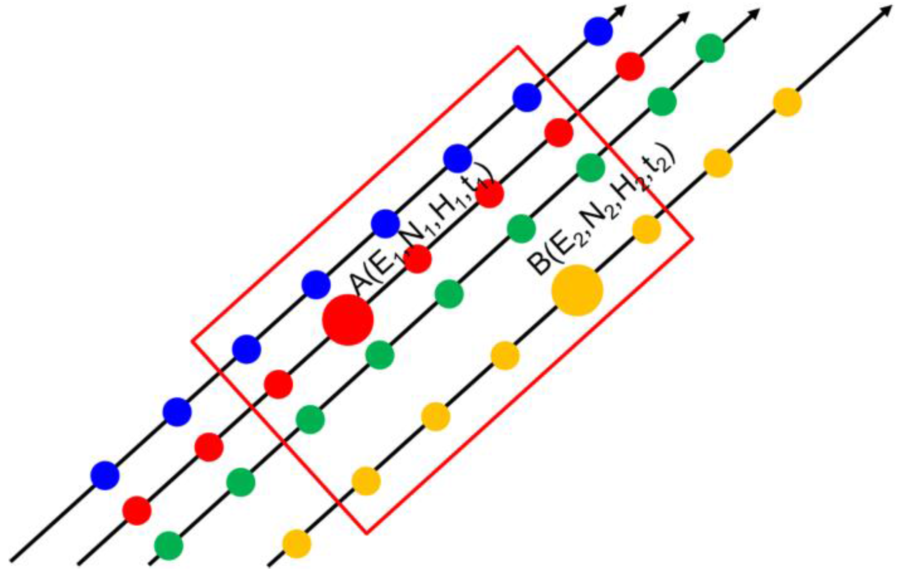
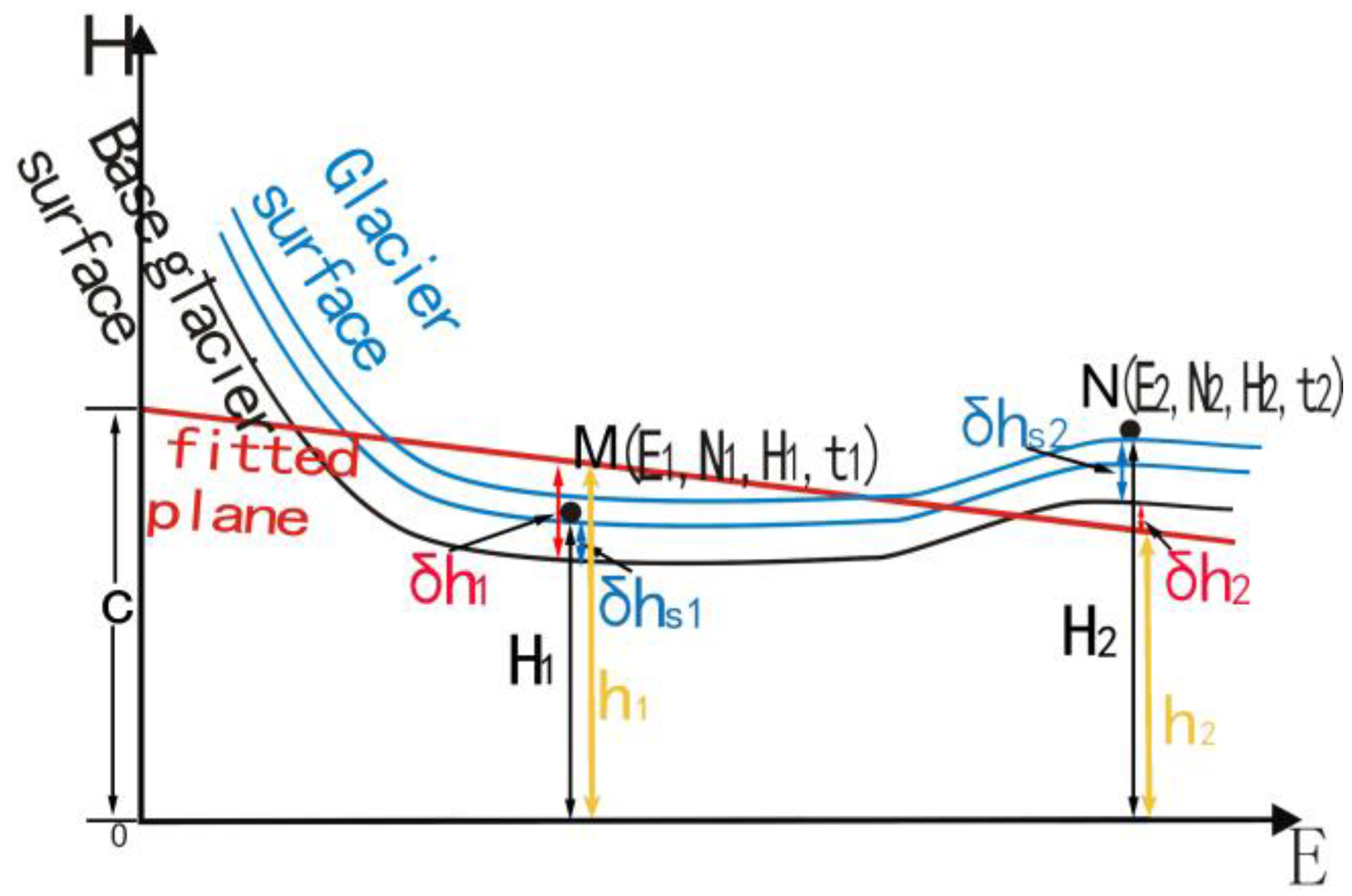
- The glacier surface can be fitted by plane; and
- (2)
- The glacier thickness change within a planar facet is constant and the shape of glacier surface remains unchanged with time, even though it moves vertically.
2. Data and Experiment Sites
2.1. ICESat/GLAS Altimetry Data
2.2. SRTM-DEM Data
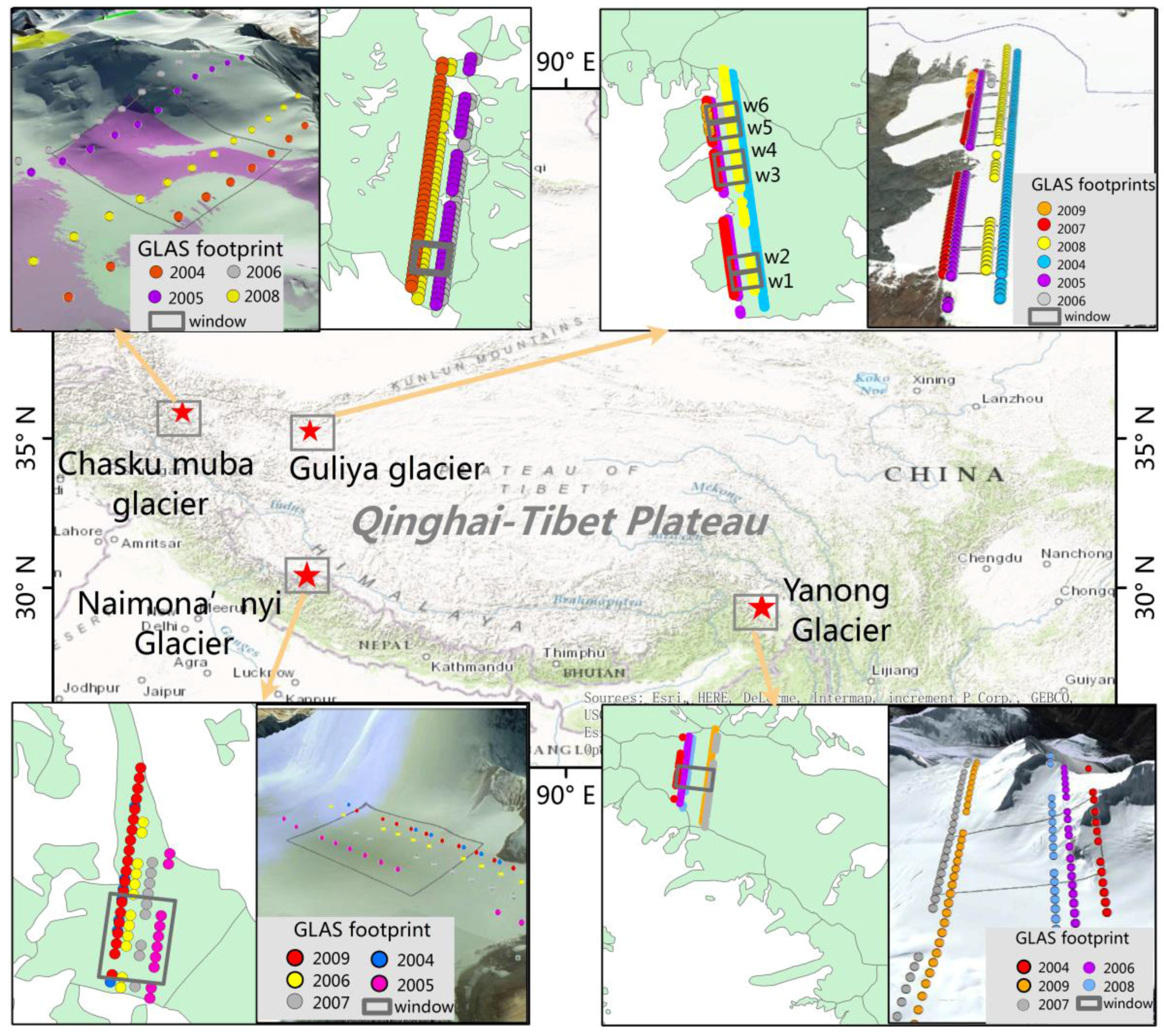
2.3. Experiment Sites
2.4. Experiments and Data Preparation
3. Methods
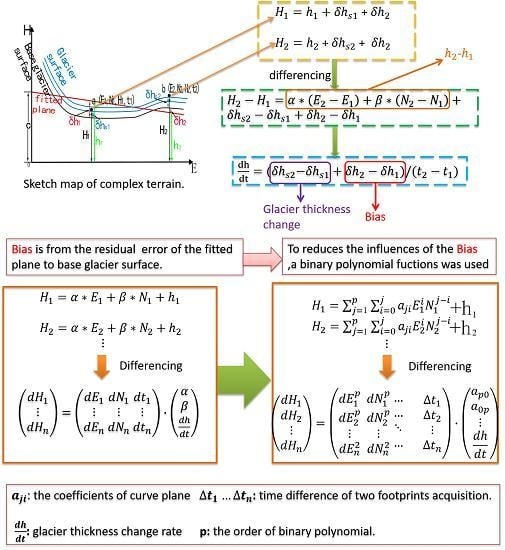
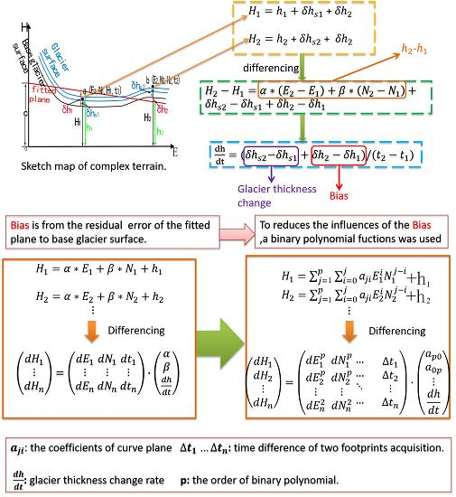
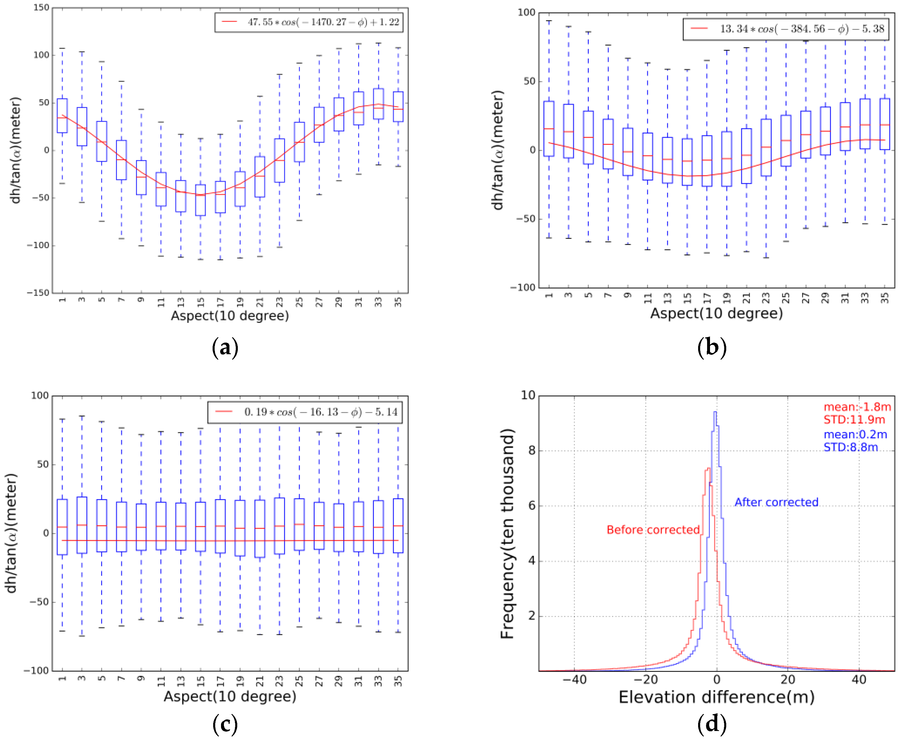
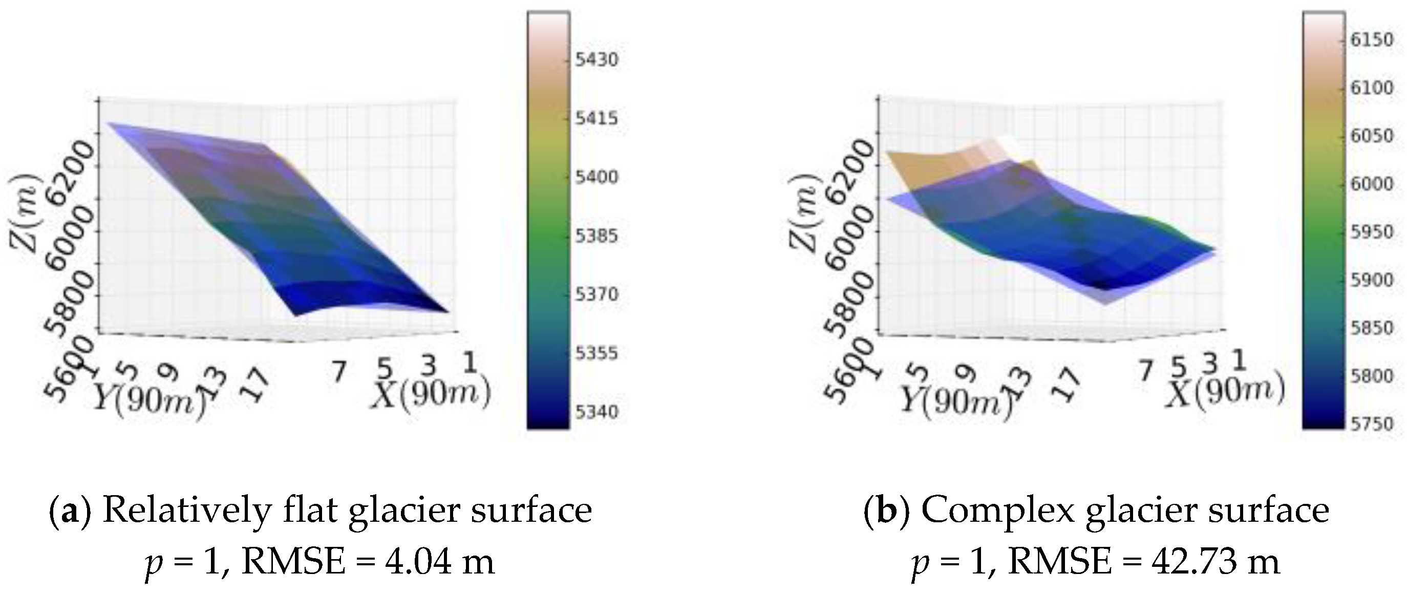
3.1. Error Analysis of the Planar Fitting Method
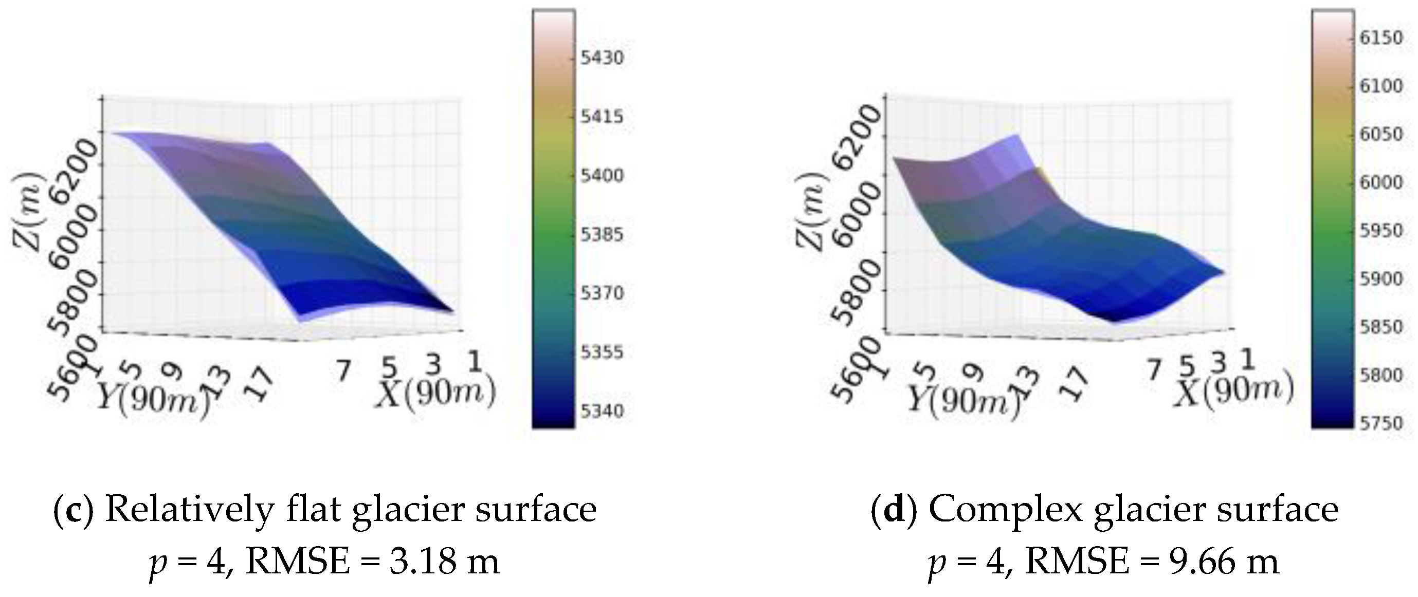
3.2. Improved Method Applicable to Complex Terrain
3.3. Setting of Parameter p on the Basis of SRTM DEM
4. Results
Application of the Improved Method to the Four Glaciers
5. Discussion
5.1. Discussion on the Assumptions
5.2. The Impact of a Non-Rigid Facet on the Calculated Mean Glacier Thickness Change
5.3. Shortcomings of the Polynomial Fitting Method
6. Conclusions
Acknowledgments
Author Contributions
Conflicts of Interest
References
- IPCC. Workshop Report of the Intergovernmental Panel on Climate Change. In Proceedings of the Workshop on Sea Level Rise and Ice Sheet Instabilities, Stockholm, Sweden, 20–21 September 2013. [Google Scholar]
- Nuimura, T.; Fujita, K.; Yamaguchi, S.; Sharma, R.R. Elevation changes of glaciers revealed by multitemporal digital elevation models calibrated by GPS survey in the Khumbu region, Nepal Himalaya, 1992–2008. J. Glaciol. 2012, 58, 648–657. [Google Scholar] [CrossRef]
- Surazakov, A.B.; Aizen, V.B. Estimating Volume Change of Mountain Glaciers Using SRTM and Map-Based Topographic Data. IEEE Trans. Geosci. Remote Sens. 2006, 44, 2991–2996. [Google Scholar] [CrossRef]
- Gardelle, J.; Berthier, E.; Arnaud, Y. Slight mass gain of Karakoram glaciers in the early twenty-first century. Nat. Geosci. 2012, 1–4. [Google Scholar] [CrossRef]
- Moholdt, G.; Nuth, C.; Hagen, J.O.; Kohler, J. Recent elevation changes of Svalbard glaciers derived from ICESat laser altimetry. Remote Sens. Environ. 2010, 114, 2756–2767. [Google Scholar] [CrossRef]
- Bamber, J.L.; Rivera, A. A review of remote sensing methods for glacier mass balance determination. Glob. Planet. Chang. 2007, 59, 138–148. [Google Scholar] [CrossRef]
- Rivera, A.; Benham, T.; Casassa, G.; Bamber, J.; Dowdeswell, J.A. Ice elevation and areal changes of glaciers from the Northern Patagonia Icefield, Chile. Glob. Planet. Chang. 2007, 59, 126–137. [Google Scholar] [CrossRef]
- Paul, F.; Bolch, T.; Kaab, A.; Nagler, T.; Nuth, C.; Scharrer, K.; Shepherd, A.; Strozzi, T.; Ticconi, F.; Bhambri, R.; et al. The glaciers climate change initiative: Methods for creating glacier area, elevation change and velocity products. Remote Sens. Environ. 2015, 162, 408–426. [Google Scholar] [CrossRef]
- Neckel, N.; Kropacek, J.; Bolch, T.; Hochschild, V. Glacier mass changes on the Tibetan Plateau 2003–2009 derived from ICESat laser altimetry measurements. Remote Sens. Lett. 2014, 9, 1–8. [Google Scholar]
- Kaab, A.; Berthier, E.; Nuth, C.; Gardelle, J.; Arnaud, Y. Contrasting patterns of early twenty-first-century glacier mass change in the Himalayas. Nature 2012, 488, 495–498. [Google Scholar] [CrossRef] [PubMed]
- Slobbe, D.C.; Lindenbergh, R.C.; Ditmar, P. Estimation of volume change rates of Greenland’s ice sheet from ICESat data using overlapping footprints. Remote Sens. Environ. 2008, 112, 4204–4213. [Google Scholar] [CrossRef]
- Howat, I.M.; Smith, B.E.; Joughin, I.; Scambos, T.A. Rates of southeast Greenland ice volume loss from combined ICESat and ASTER observations. Geophys. Res. Lett. 2008, 35, 1–5. [Google Scholar] [CrossRef]
- Fricker, H.A.; Padman, L. Ice shelf grounding zone structure from ICESat laser altimetry. Geophys. Res. Lett. 2006, 33, 1–5. [Google Scholar] [CrossRef]
- Phan, V.H. Observing Changes in Lake Level and Glacial Thickness on the Tibetan Plateau with the ICESat Laser Altimeter. Ph.D. Thesis, Delft University of Technology, Delft, The Netherlands, 2015. [Google Scholar]
- Schutz, B.E. Laser Footprint Location (Geolocation) and Surface Profiles—Technical Report of Geoscience Laser Altimeter System (GLAS); The University of Texas: Austin, TX, USA, 2002. [Google Scholar]
- Duong, H.; Lindenbergh, R.; Pfeifer, N.; Vosselman, G. Single and two epoch analysis of ICESat full waveform data over forest areas. Int. J. Remote Sens. 2008, 29, 1453–1473. [Google Scholar] [CrossRef]
- Nuth, C.; Kaab, A. Co-registration and bias corrections of satellite elevation data sets for quantifying glacier thickness change. Cryosphere 2011, 5, 271–290. [Google Scholar] [CrossRef]
- NASA. SRTM Homepage. Available online: https://lta.cr.usgs.gov/SRTM (accessed on 1 August 2015).
- Phan, V.H.; Lindenbergh, R.C.; Menenti, M. Orientation dependent glacial changes at the Tibetan Plateau derived from 2003–2009 ICESat laser altimetry. Cryosphere Discuss. 2014, 8, 2425–2463. [Google Scholar] [CrossRef]
- Gorokhovich, Y.; Voustianiouk, A. Accuarcy assessment of the processed SRTM-based elevation data by CGIAR using field data from USA and Thailand and its relation to the terrain characteristics. Remote Sens. Environ. 2006, 104, 409–415. [Google Scholar] [CrossRef]
- Peduzzi, P.; Herold, C.; Silverio, W. Assessing high altitude glacier thickness, volume and area changes using field, GIS and remote sensing techniques: The case of Nevado Coropuna (Peru). Cryosphere 2010, 4, 313–323. [Google Scholar] [CrossRef]
- Shi, J.C.; Menenti, M.; Lindenbergh, R. Parameterization of surface roughness based on ICESat/GLAS full Waveforms: A case study on the Tibetan Plateau. J. Hydrometeorol. 2013, 14, 1278–1292. [Google Scholar] [CrossRef]
- Zwally, H.J.; Schutz, R.; Bentley, C.; Bufton, J.; Herring, T.; Minster, J.; Spinhirne, J.; Thomas, R. GLAS/ICESat L2 Antarctic and Greenland Ice Sheet Altimetry Data, Version 34. Available online: http://nsidc.org/data/docs/daac/glas_icesat_l1_l2_global_altimetry.gd.html (accessed on 1 August 2015).
- Tian, L.; Zong, J.; Yao, T.; Ma, L.; Pu, J.; Zhu, D. Direct measurement of glacier thinning on the southern Tibetan Plateau (Gurenhekou, Kangwure and Naimona’Nyi glaciers). J. Glaciol. 2014, 60, 879–887. [Google Scholar] [CrossRef]
- Zhu, D.Y. Changes of Ice Thickness for Typical Glaciers in Different Areas of Tibetan Plateau. Ph.D. Thesis, Southwest University, Chongqing, China, 2015. [Google Scholar]
- Nie, Y.; Zhang, Y.L.; Liu, L.S.; Zhang, J.P. Glacial change in the vicinity of Mt. Qomolangma (Everest), central high Himalayas since 1976. J. Geogr. 2010, 20, 667–686. [Google Scholar] [CrossRef]
- Liu, S.Y.; Shangguan, D.H.; Ding, Y.J.; Han, H.; Zhang, Y.; Wang, J.; Xie, C.; Ding, L.; Li, G. Glacier variations since the early 20th century in the Gangrigabu range, southeast Tibetan Plateau. J. Glaciol. Geocryol. 2005, 27, 55–63. (In Chinese) [Google Scholar]


| 2003 | 2004 | 2005 | 2006 | 2007 | 2008 | 2009 | Area (km2) | Roughness (m) | |
|---|---|---|---|---|---|---|---|---|---|
| Naimona’nyi Glacier | - | 3 | 9 | 11 | 8 | - | 19 | 7.3 | 10.6 |
| Yanong Glacier | - | 13 | 24 | - | 29 | 21 | 33 | 17.9 | 49.1 |
| Guliya Glacier | - | 79 | 61 | 3 | 53 | 59 | 6 | 111.3 | 14.7 |
| Chasku Muba Glacier | - | 39 | 35 | 32 | - | 37 | - | 43.7 | 38.4 |
| Polynomial Fitting (p = 4) | Planar Fitting (p = 1) | Longitude | Latitude |
|---|---|---|---|
| 12.79 | 54.68 | 90.886 | 33.532 |
| 12.55 | 72.15 | 90.872 | 33.53 |
| 4.74 | 21.67 | 82.327 | 34.757 |
| 12.27 | 29.51 | 82.377 | 34.775 |
| 12.59 | 35.91 | 77.464 | 35.733 |
| 5.34 | 22.9 | 77.639 | 35.688 |
| dh/dt (m/year) | Polynomial Fitting (2000–2008/2009) | DGPS Measurement [25] (2008–2010) | DGPS Measurement [24] (2005–2013) | |||
|---|---|---|---|---|---|---|
| p | 1 | 4 | ||||
| Length | ||||||
| Naimona’nyi Glacier | 1000 (m) | −0.55 | −0.66 | −0.67 | −0.45 | |
| 1500 (m) | −1.88 | −0.46 | ||||
| 2000 (m) | −2.45 | −0.97 | ||||
| 2500 (m) | −3.28 | −0.82 | ||||
| Yanong Glacier | 1000 (m) | 2.89 | −1.07 | * | * | |
| 1500 (m) | 4.39 | −0.84 | ||||
| 2000 (m) | 2.82 | −0.78 | ||||
| 2500 (m) | 2.6 | −0.45 | ||||
| dh/dt (m/year) | Polynomial Fitting (2000–2008/2009) | Linear Temporal Trend (2004–2008/2009) | |||
|---|---|---|---|---|---|
| P= | 1 | 4 | dh/dt | q | |
| Guliya glacier | W1 | 1.64 | 1.06 | 0.39 ± 0.78 | 0.32 |
| W2 | 0.64 | 0.60 | 0.67 ± 0.54 | 0.01 | |
| W3 | 0.74 | 0.39 | 0.48 ± 1.3 | 0.4 | |
| W4 | 3.6 | 0.47 | 0.61 ± 0.8 | 0.03 | |
| W5 | −0.94 | 0.35 | 0.42 ± 0.58 | 0.09 | |
| W6 | 0.32 | 0.39 | 0.04 ± 0.52 | 0.86 | |
| Chasku Muba Glacier | 4.39 | 0.83 | 0.58 ± 0.71 | 0.11 | |
| Year of GLAS | E4 | N4 | E3N | E2N2 | EN3 | E3 | N3 | E2N | EN2 | E2 | N2 | EN | E | N |
|---|---|---|---|---|---|---|---|---|---|---|---|---|---|---|
| 2004 | –1.07 × 10⁴ | 5.07 × 10⁷ | 1.17 × 10⁵ | –2.39 × 10⁶ | 4.19 × 10⁷ | –6.22 × 100 | –2.88 × 10³ | 6.43 × 101 | –1.14 × 10³ | –3.14 × 10⁻³ | 8.91 × 10⁻² | 3.31 × 10⁻² | –2.36 × 10⁻¹ | 2.04 × 10⁻¹ |
| 2006 | –1.09 × 10⁴ | –1.75 × 10⁸ | 1.20 × 10⁵ | –2.51 × 10⁶ | 4.67 × 10⁷ | –6.18 × 100 | 6.33 × 10³ | 6.89 × 101 | –1.29 × 10³ | –3.13 × 10⁻³ | –1.27 × 10⁻¹ | 3.61 × 10⁻² | –2.47 × 10⁻¹ | 1.97 × 10⁻¹ |
| 2007 | –8.30 × 10³ | 1.80 × 10⁸ | 8.27 × 10⁴ | –1.62 × 10⁶ | 2.61 × 10⁷ | –4.82 × 100 | –2.97 × 10³ | 4.63 × 101 | –7.12 × 10² | –2.30 × 10⁻³ | 5.64 × 10⁻² | 2.00 × 10⁻² | –2.49 × 10⁻¹ | 1.96 × 10⁻¹ |
| 2008 | –1.11 × 10⁴ | –1.82 × 10⁸ | 1.18 × 10⁵ | –2.42 × 10⁶ | 4.36 × 10⁷ | –6.36 × 100 | 4.45 × 10³ | 6.81 × 101 | –1.26 × 10³ | –3.26 × 10⁻³ | –1.58 × 10⁻¹ | 3.45 × 10⁻² | –2.48 × 10⁻¹ | 2.05 × 10⁻¹ |
| all | –1.08 × 10⁴ | 1.62 × 10⁷ | 1.11 × 10⁵ | –2.16 × 10⁶ | 3.83 × 10⁷ | –6.20 × 100 | 2.67 × 10³ | 6.20 × 101 | –1.06 × 10³ | –3.12 × 10⁻³ | –8.13 × 10⁻² | 3.11 × 10⁻² | –2.34 × 10⁻¹ | 2.03 × 10⁻¹ |
| dh/dt (m/year) | Planar Fitting (p = 1) | Polynomial Fitting (p = 4) | ||
|---|---|---|---|---|
| Mean | 3 × σ | Mean | 3 × σ | |
| Naimona’nyi Glacier | −1.83 | 0.13 | −0.46 | 0.08 |
| Yanong Glacier | 3.34 | 0.25 | −0.77 | 0.15 |
| Chasku Muba Glacier | 4.44 | 0.81 | 0.85 | 0.45 |
| Planar Fitting (p = 1) | Polynomial Fitting (p = 4) | Fitting a Trend (2004–2008) | |
|---|---|---|---|
| dh/dt | q | ||
| −2.94 | −1.5 | −0.18 ± 4.18 | 0.93 |
© 2017 by the authors. Licensee MDPI, Basel, Switzerland. This article is an open access article distributed under the terms and conditions of the Creative Commons Attribution (CC BY) license (http://creativecommons.org/licenses/by/4.0/).
Share and Cite
Huang, T.; Jia, L.; Menenti, M.; Lu, J.; Zhou, J.; Hu, G. A New Method to Estimate Changes in Glacier Surface Elevation Based on Polynomial Fitting of Sparse ICESat—GLAS Footprints. Sensors 2017, 17, 1803. https://doi.org/10.3390/s17081803
Huang T, Jia L, Menenti M, Lu J, Zhou J, Hu G. A New Method to Estimate Changes in Glacier Surface Elevation Based on Polynomial Fitting of Sparse ICESat—GLAS Footprints. Sensors. 2017; 17(8):1803. https://doi.org/10.3390/s17081803
Chicago/Turabian StyleHuang, Tianjin, Li Jia, Massimo Menenti, Jing Lu, Jie Zhou, and Guangcheng Hu. 2017. "A New Method to Estimate Changes in Glacier Surface Elevation Based on Polynomial Fitting of Sparse ICESat—GLAS Footprints" Sensors 17, no. 8: 1803. https://doi.org/10.3390/s17081803
APA StyleHuang, T., Jia, L., Menenti, M., Lu, J., Zhou, J., & Hu, G. (2017). A New Method to Estimate Changes in Glacier Surface Elevation Based on Polynomial Fitting of Sparse ICESat—GLAS Footprints. Sensors, 17(8), 1803. https://doi.org/10.3390/s17081803