Article

Exploring Zoogeomorphological Landscapes: Enhancing Learning Through Virtual Field Experiences of Beaver Ponds Along the Red Eagle Trail, Glacier National Park, Montana, USA

1
College of General Studies, University of Phoenix, Phoenix, AZ 85040, USA
2
Science in Environmental Studies Program, Prescott College, AZ 86301, USA
3
Department of Geography, Texas State University, San Marcos, TX 78666, USA
4
Department of Landscape Architecture, Davis College, Texas Tech University, Lubbock, TX 79409, USA
5
Department of Cultural Sciences, Mesa Community College, Mesa, AZ 85202, USA
6
AI/ML Architect, Sensus Loci LLC, Austin, TX 78728, USA
7
School of Geographical Sciences and Urban Planning, Arizona State University, Tempe, AZ 85287, USA
8
Mary Lou Fulton Teacher’s College, Arizona State University, Tempe, AZ 85212, USA
*
Author to whom correspondence should be addressed.
Submission received: 15 November 2024 / Revised: 22 February 2025 / Accepted: 11 March 2025 / Published: 25 March 2025

Simple Summary

Virtual field experiences in zoogeomorphology offer students in an online classroom a chance to study beaver influence using immersive landscapes, and as ecosystem engineers, beavers affect stream hydrology, sediment transport, and vegetation patterns, leading to complex landscape changes. A virtual reality learning environment using 360-degree spherical photography, historical photos, and field notes highlights the temporal and spatial changes caused by beavers. A normalized difference water index (NDWI) is used as an educational tool to help learners examine surface water conditions and landscape patterns, allowing students to assess water retention and the impact of sediment trapping and flooding on vegetation. Finally, a measurement scale is presented to evaluate education theory consistency and fidelity in virtual learning experiences. Theory-informed virtual field experiences in zoogeomorphology that leverage immersive landscapes and educational tools, like the NDWI, can support students in understanding the impact of beavers on stream hydrology and geomorphic processes and their potential for climate adaptation interventions.

Abstract

Virtual field trips in zoogeomorphology can allow students to explore the dynamic influence of beaver activity within the landscape. Education theory-informed virtual learning experiences (VLEs) of zoogeomorphologic topics, such as ecosystem engineers, are still underdeveloped for natural science learning communities. Through dam-building activities, beavers significantly alter stream hydrology, sediment transport, and vegetation organization and structure, promoting landscape heterogeneity. To effectively communicate this complexity of landscape modification, we developed an immersive virtual reality (VR) environment using historical photographs and detailed field notes to visualize the temporal and spatial transformations caused by beaver activity. A design and development process (TECCUPD), a philosophical framework for physical geography (TREE-PG), and a planning tool (VRUI conceptual model) are used to guide VLE architecture. Collectively, this information serves as a virtual proxy of an abandoned beaver pond field site to support student evaluation of the influence of sediment trapping and flooding on vegetation patterns on the landscape. This virtual place-based, experiential narrative environment is a proxy to capture the complexity of beaver-modified landscapes through ecological and geomorphological interactions. The integration of immersive VR technologies and generative artificial intelligence (AI) in higher education with learning theories that guide VR application design and development is applied in virtual field trips to support pedagogical goals and improve learning outcomes. Finally, we use an evaluation scale (TIPS) to assess the fidelity of learning theory implementation in a virtual field trip. Virtual field experiences in zoogeomorphology, informed by theory and utilizing immersive landscapes and scientific educational tools, can help students discern the effects of beavers on stream hydrology and geomorphic processes, as well as their potential role in mitigating water insecurity in climate adaptation efforts.

1. Introduction

1.1. Supporting Field and Remote Sensing Skills for Identifying Zoogeomorphic Influence

To improve landscape resilience, landscape architects, managers, and ecologists emulate living systems in their designs with site-specific integration of natural elements that mediate water retention into landscape planning and design [1]. A hotter and drier climate trend may increase the potential for more heat waves and extreme shifts in precipitation events [2]. Nature’s ecosystem engineers, the American beaver (Castor canadensis) and their Eurasian counterpart (Castor fiber), significantly impact landscape dynamics and ecological balance and configuration of water on the landscape [3,4,5,6]. Goldfarb [7] reported that landscape managers promote a “Beaver Believers” movement and are using the beaver species as an active participant in restoring the environmental shifts in hydrological systems towards positive retention with less expense and, as such, encourage rewilding as a cost-effective measure to conserve local-scale water resources. Castor sp. adjusts landscape dynamics and water distribution, promoting the landscape’s water resilience in the face of warming temperatures and increased drought frequency due to anthropogenic climate change. This species’ ability to influence hydrological cycles supports biodiversity and contributes to floodplain connectivity, making them valuable allies in landscape-scale climate adaptation strategies.

1.2. Aligning Landscape Design and Ecological Systems Interpretation to Higher Education

Undergraduate education curricula must develop expertise to ensure students have the knowledge and skills needed to navigate the complexities of landscape interpretation and design, preparing them for careers that require interdisciplinary approaches [8,9]. By incorporating diverse topics like ecosystem engineering, geomorphology, rewilding, and ecological restoration, students can be trained to detect spatial patterns and processes at site-level to landscape-level scales. Understanding how to incorporate species such as C. candadensis into landscape design and management plans contributes to fields informed by natural landscape interventions to address environmental challenges.

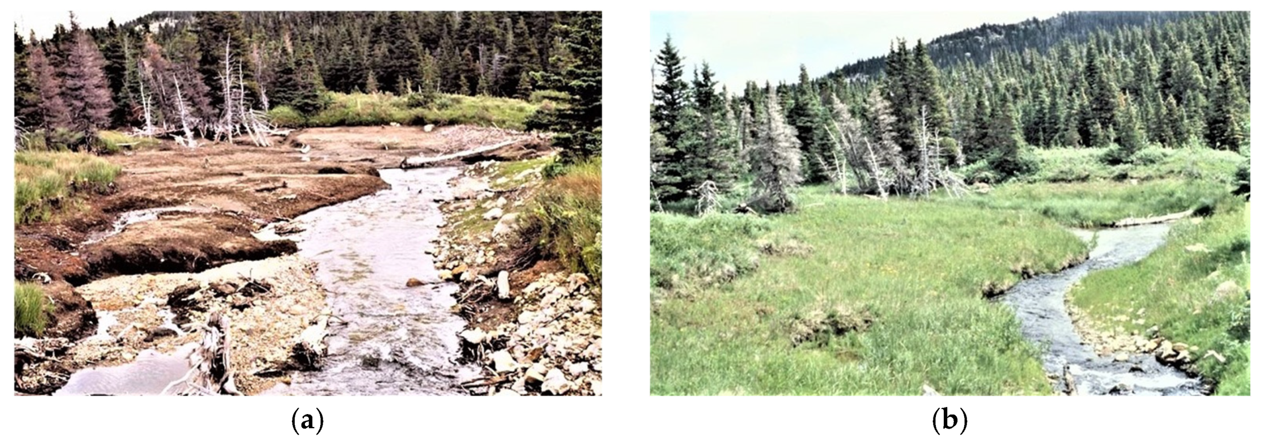
1.3. Overview of Beavers and Ecological Resilience

Zoogeomorphology examines how animals like C. canadensis act as geomorphic agents, significantly shaping landforms and surface processes through activities such as dam building [3]. Researchers consider these keystone species and ecosystem engineers because of their extensive environmental modifications, which create, expand, and alter riparian ecosystems [4]. C. canadensis dam construction uses woody vegetation to impound stream flows, retaining water, sediments, and nutrients, which leads to lasting ecosystem changes even after the dam collapses [5,6]. Their activities alter fluvial dynamics, creating press (persistent over long periods of time) and pulse (brief in a short period of time) disturbances that decrease stream velocity, increase sediment deposition, and widen and deepen water channels, enhancing floodplain connectivity and promoting aquatic and riparian plant growth [10,11]. Beaver ponds also develop diverse microhabitats housing diverse invertebrates, amphibians, and fish [7]. Additionally, beavers expand wetland areas by connecting them with lateral channels, thus increasing the area and complexity of these ecosystems [12]. The high surface area and shoreline complexity of beaver ponds enhance nitrogen retention and promote sediment deposition, contributing to ecological resilience, particularly under fluctuating water levels during periods of drought and flood [6,13]. Although beaver dams are transient features prone to abandonment and collapse, the sediment and vegetation they leave behind can lead to long-term ecological benefits, such as increased fertility and topographic roughness that influence stream dynamics [14]. Despite the historical decline in beaver populations due to trapping and human activities [15], conservation efforts are growing interest in beaver recovery and its potential to restore ecological and fluvial processes on a localized scale, mainly using beaver dam analogs [1,16]. Beaver recovery, when coupled with the restoration of other environmental components, may also aid in mitigating biodiversity loss, which is critical to supporting ecosystem resilience [17,18].

1.4. The Goal of This Work

This paper addresses the lack of theory-informed virtual learning experiences (VLEs) covering science education topics [19,20], emphasizing zoogeomorphology, mainly how animals influence and shape landforms. In a systematic review of VR experiences found in all domains of education, Radianti et al. [19] (p. 4) noted, “The most popular application domains covered in these systematic reviews were medicine (78%), social science (15%), neuroscience (11%), and psychology (11%)”. Additionally, these authors noted that for the field of engineering and the sciences, one of the five “future directions” is “VR-enhanced online education” [21] (p. 5). Over three decades, a bibliometric analysis of VR and education detected a notable gap in VR experiences for the natural sciences that build science literacy [20]. Even with medicine dominating the VR domains, there is a scarcity of education theory applied to VLEs for VR and education [22,23]; “research rarely integrates VR into medical education’s pedagogical and learning aspects. Questionnaires and guidelines for implementing VR are also scarce” [21] (p. 59). This paper focuses on supporting instructional designers and VLE architects in the natural sciences to develop education theory-informed field-based science VLEs. We aim to help natural science educators with methodological and theoretical frameworks for VLE resource capture and design to fill the void in virtual proxies of environments that build scientific literacy. Part one of the paper briefly overviews field and place-based frameworks for VLE design, assuming a limited background in VLE architecture or education theory. In part two of the paper, we describe the integration of the stepwise process theory, exploration, capture, curate, user, publish, and disseminate (TECCUPD) for VLE lesson design and dissemination [22] with the conceptual framework, translating research in environmental education for physical geography (TREE-PG) [23]. We apply these to the virtual reality user interface (VRUI) model as a curriculum planning tool for connecting theoretical elements to VLE components [23]. Also in part two, we demonstrate the design process using an example of beaver ponds located in a lower montane valley in Glacier National Park, Montana, USA. Finally, part three of this paper reviews using an ordinal evaluation scale, the TREE-PG implementation prioritization scale (TIPS), to assess the fidelity of learning theory implementation in a virtual field trip.

2. Part I: Bridging Theory and Practice in VLE Development: Zoogeomorphology Through TECCUPD, TREE-PG, and VRUI

Education content designers use diverse learning theories to create compelling learning experiences, which inform their understanding of knowledge acquisition and learning limitations. Incorporating these theories into methodological and conceptual frameworks of VLE development increases the likelihood of reaching the learning goals of field lessons in field-based STEM education [23,24]. The translating research in environmental education (TREE) theoretical framework is grounded in seminal educational concepts that help guide the design of online environments, ensuring they are consistent, engaging, and structured [23,24,25]. Higher-level virtual learning environments (VLEs) that adopt various pedagogical methods based on outlined objectives and goals create intentional design choices to increase the potential for meaningful learning outcomes.
TREE-PG is an adaptation of that framework designed to support field scientists and educators to create lessons informed by educational theories for field and place-based experiences in physical geography, as shown in table 1 in Ref. [23] (p. 60). This approach to learning is applied to academic resources and content across various field-aligned disciplines. Understanding these learning theories is particularly important for environmental education, as many scientists lack training in these theories and how to use them to enhance student learning experiences.
To craft the virtual learning experience with theory integration considered in all components of the VLE (learning objectives, photosphere, instructional interventions, and contextual application), the ordered virtual reality user interface (VRUI) planning tool is used, as shown in figure 1 and table 2 of Ref. [23] (pp. 61–62). VLE architects can use the model deconstruction of the components to apply specific learning theories based on learning designer intentions. To illustrate the TREE-PG theoretical framework, the TECCUPD stepwise process, and the VRUI planning tool in action, we will use the example of Castor as the zoogeomorphic agent to assess zoogeomorphic environments and landscape modification for a field site evaluation of a mountain delta floodplain beaver pond VLE.

3. Part II: Developing the Red Eagle Trail and Beaver Pond Loop VLE Using TECCUPD, TREE-PG, and VRUI

Learning theory helps VLE creators think about what information they need when gathering resources for developing virtual learning environments. Using the “TECCUPD stepwise development process” (Gielstra et al., figure 1), VLE development involves three phases that break down to preparation (Step 1: theory and Step 2: exploration), development (Step 3: capture, Step 4: curate, and Step 5: user), and implementation (Step 6: publish and Step 7: disseminate) [22]. Phase 1 guides educational designers in selecting the appropriate theories for the learning experience and applying these theories to the academic goals and outcomes of the lesson, thereby facilitating student learning. Phase 2 has the learning experience developer take the field photography and notes, organize these data, and assemble the information into a tangible learning experience. Phase 3 involves the publication of the VLE to share broadly with the learning community.
This section describes the process of VLE development from the initial ideation of the topic, resource collection, refinement, and distribution for an introductory college class in conservation biology in an online, asynchronous undergraduate environmental science program. We use all the guiding frameworks and tools to track the development process with the design goal of achieving maximum learning outcomes for the student:
  • To identify relationships between beaver ponds and geomorphic change;
  • To examine beaver impacts on ecosystems.
There is a blend of fieldwork and resources, education theory, and technical components. The following narrative shows how a VLE architect implemented TECCUPD, TREE-PG, and VRUI to produce a zoogeomorphology virtual field trip.

3.1. TECCUPD Phase 1 Preparation, Step 1 (Theory): TREE-PG-Chosen Constructs, VRUI Order Core Learning Objectives

In this section, we apply TREE-PG and the TECCUPD stepwise process to present the development of a VLE centered on using an immersive digital proxy for a mountain alluvial plain and delta beaver ponds. To begin, we aligned the learning goals to the VLE Theoretical Framework defined in TREE-PG, examining zoogeomorphic agents’ influence on geomorphological and hydrological elements of the landscape at a site specific to landscape scales. We identified the TREE-PG constructs from Kelly et al.’s table 2 for use in developing the VLE [23] (p. 62). We intentionally chose them to build the learner’s knowledge and skills to recognize those interactions and their results. We use social constructivism in the group project design by hosting discussions in a forum where the teacher serves as a moderator. In this setting, students role-play as environmental scientists, physical geographers, and landscape architects, collaborating to incorporate beavers into a landscape design aimed at preserving water and enhancing climate adaptation. This approach helps deepen their understanding of physical geography, geomorphology, and landscape architecture as they work together as a city planning team. We use conceptual change theory to build on what students already know and help them work together to improve their understanding. They can refine their ideas to be more technically and scientifically accurate by collaborating. This activity design helps them develop more precise mental models of features, patterns, and processes in their landscape design project [23]. We apply systemic functional linguistics (SFLs) to carefully consider the chosen language for the learning objectives to maintain context and accuracy for the intended audience and emphasize scientific accuracy, meaning, and tone. Spatial thinking is used in the core learning objectives as zoogeomorphic agents influence hydrological and geomorphic processes that create patterns in the landscape. We seek to provide visual examples to guide students’ identification of both beaver presence and their interactions on the landscape that forms beaver ponds and their geographical distribution. Spatial thinking links the patterns of features to active processes. Through this approach, students build essential problem-solving skills necessary for science by analyzing and interpreting data to spot patterns of how beavers shape the landscape and impact the environment.
We used Strabo AI, a customized AI with resourced content that is geo-specific, open, educationally focused, and designated for free and fair use, to guide the VLE architect in developing educational goals and learning objectives (Figure 1).
We analyzed the chat and completion text for appropriate faithfulness, context precision, and answer relevancy [27]. Once the information was analyzed and vetted, we developed the educational goals and learning objectives (Table 1).
Based on the AI suggestions for educational goals, we crafted simple learning objectives (LOs). The VLE focuses on the educational value of ecosystem engineers to site water retention. We used key topics from landscape architecture, geomorphology, and physical geography to meet the high-level learning objectives developed for the VLE to achieve the following:
  • To identify signs of beaver presence on the landscape;
  • To examine beaver ponds in a mountain floodplain landscape.
However, we wanted to refine these objectives so that the conservation biology course aligned more with disciplines specializing in interpreting landscapes, physical geography, geomorphology, and landscape architecture, producing a more versatile VLE that might serve many different learning communities. We used Strabo AI again to task the AI with role-playing as an undergraduate instructor from a physical geography course, a geomorphology course, and a landscape architecture course, prompting an inquiry each time about how to best adapt these learning objectives to each discipline (Figure 2).
We chose the following learning objectives and refined them [28]:
  • Analyze beaver presence on the landscape relative to their ecological and geomorphic impacts.
  • Investigate the geomorphic features and processes associated with beaver ponds in mountain floodplain landscapes, focusing on hydrology, sedimentation, and landscape evolution.
  • Evaluate the ecological and geomorphological implications of beaver presence in landscape architecture by integrating beaver-induced features into landscape design.
These learning objectives should yield maximized outcomes for students to observe the environment for signs of Castor. activity and movement at the site-level scale and the ecosystem-level influence from remotely sensed data.

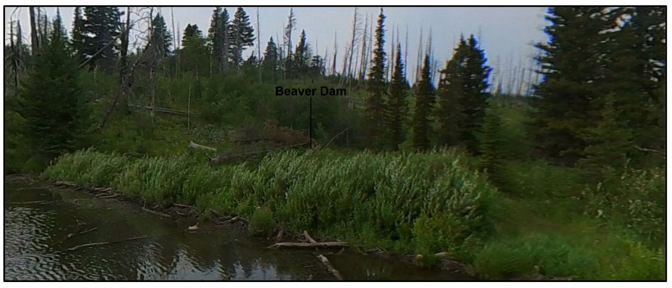
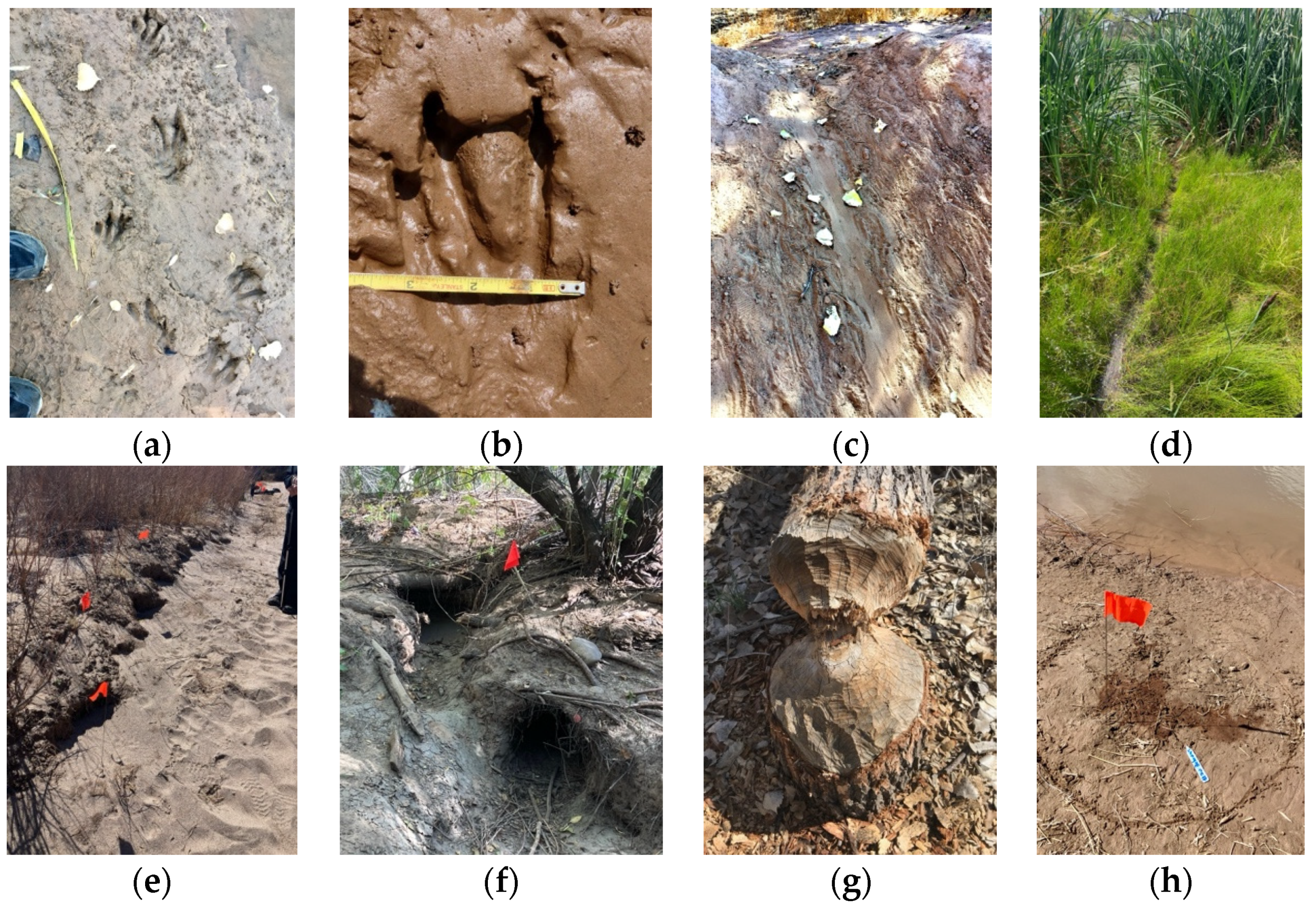
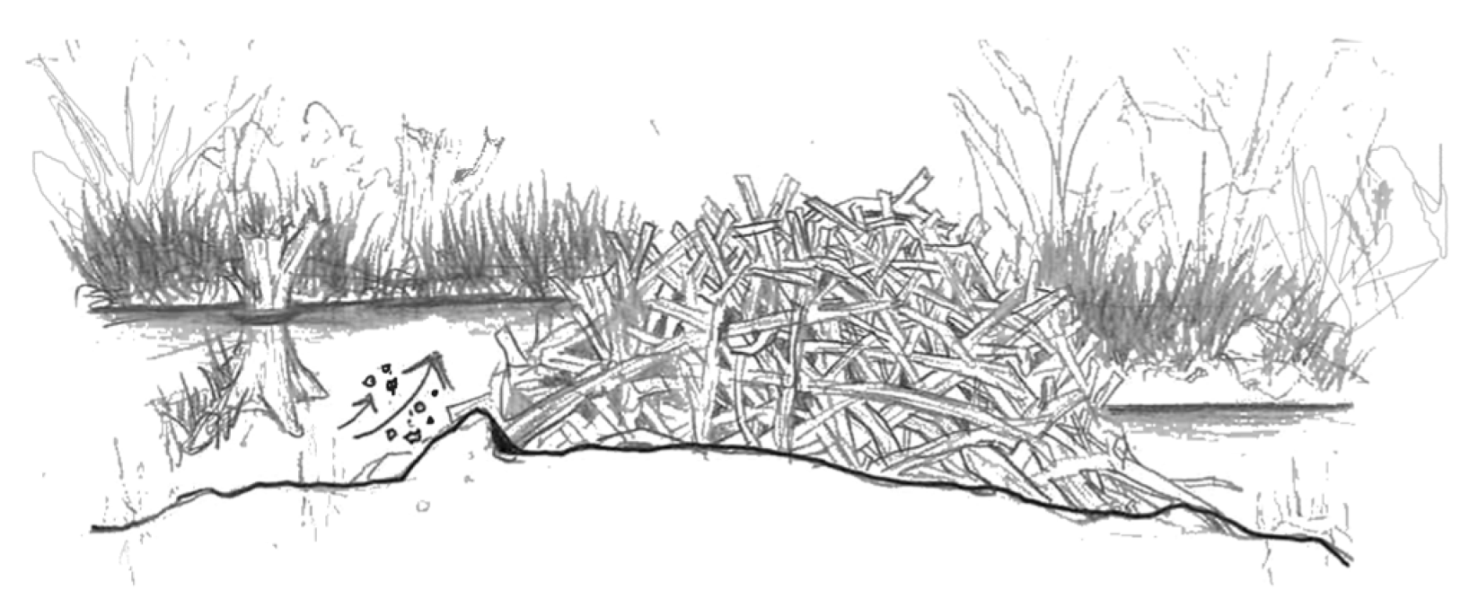
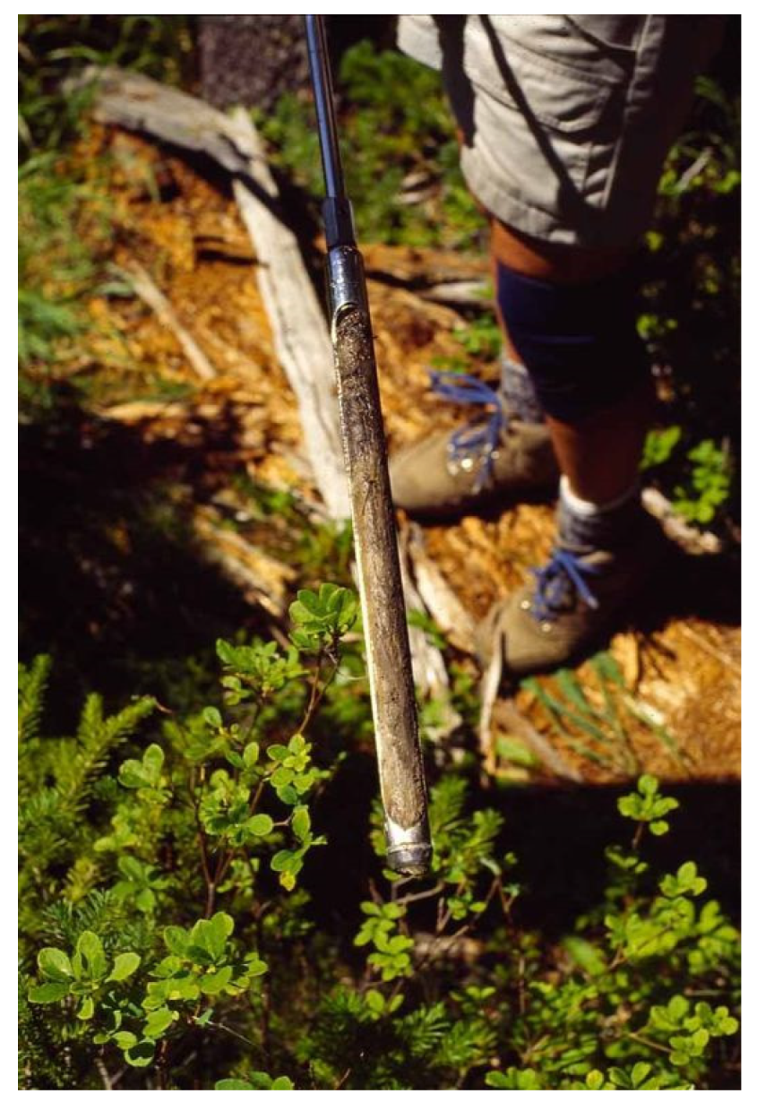
3.2. TECCUPD Phase 1 Preparation, Step 2 (Exploration): Beaver Signs on the Landscape

This section describes the site of exploration and fieldwork conducted during the summer of July 2021. We collected resources (videos, 360-degree photography, landscape imagery, macro images, and field notes) associated with beaver habitat and ecosystem modification from this site. We used these resources to develop the resulting lesson, Field Trip: Beaver Ponds Along the Red Eagle Trail, Glacier National Park, Montana, USA [29].

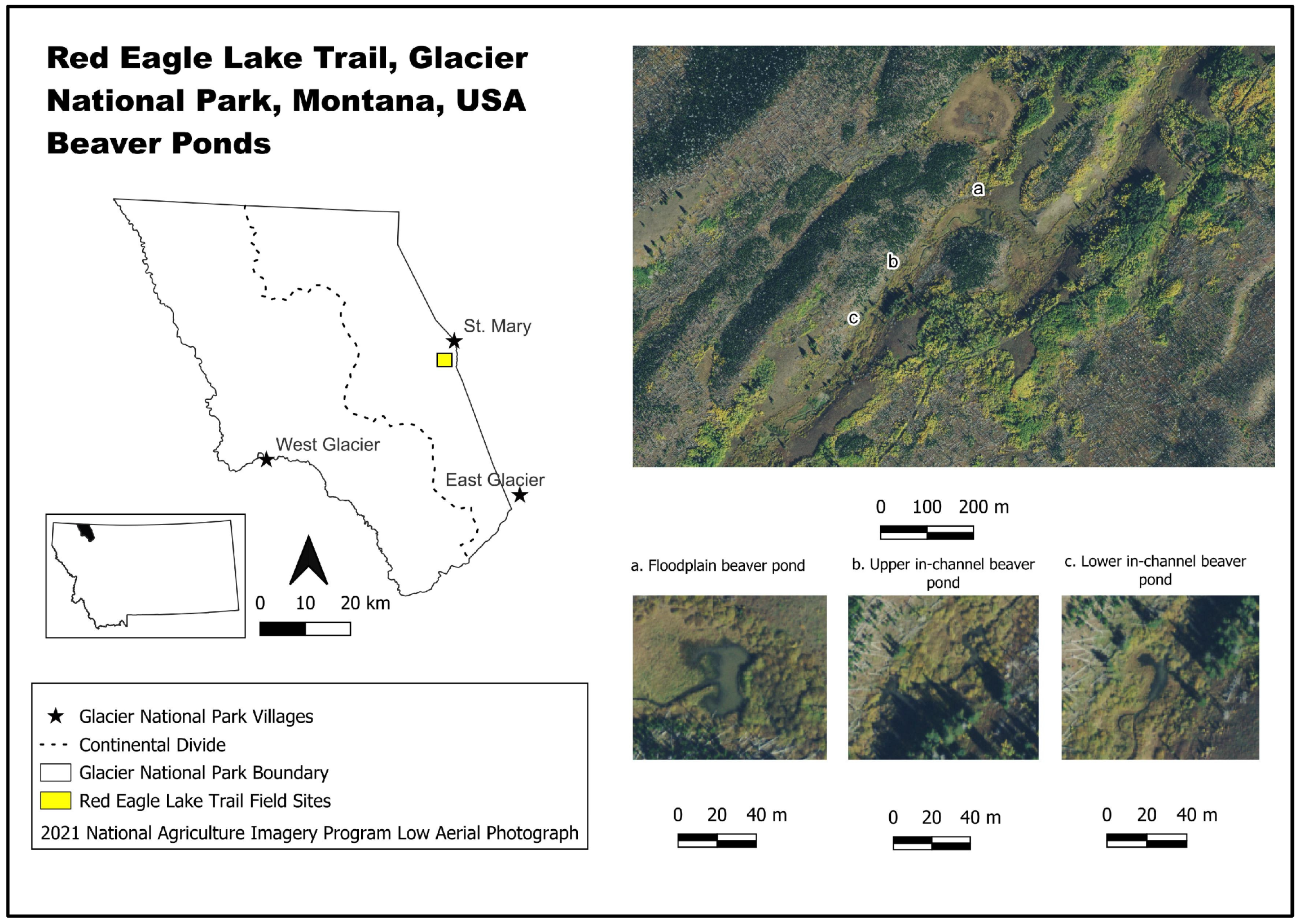
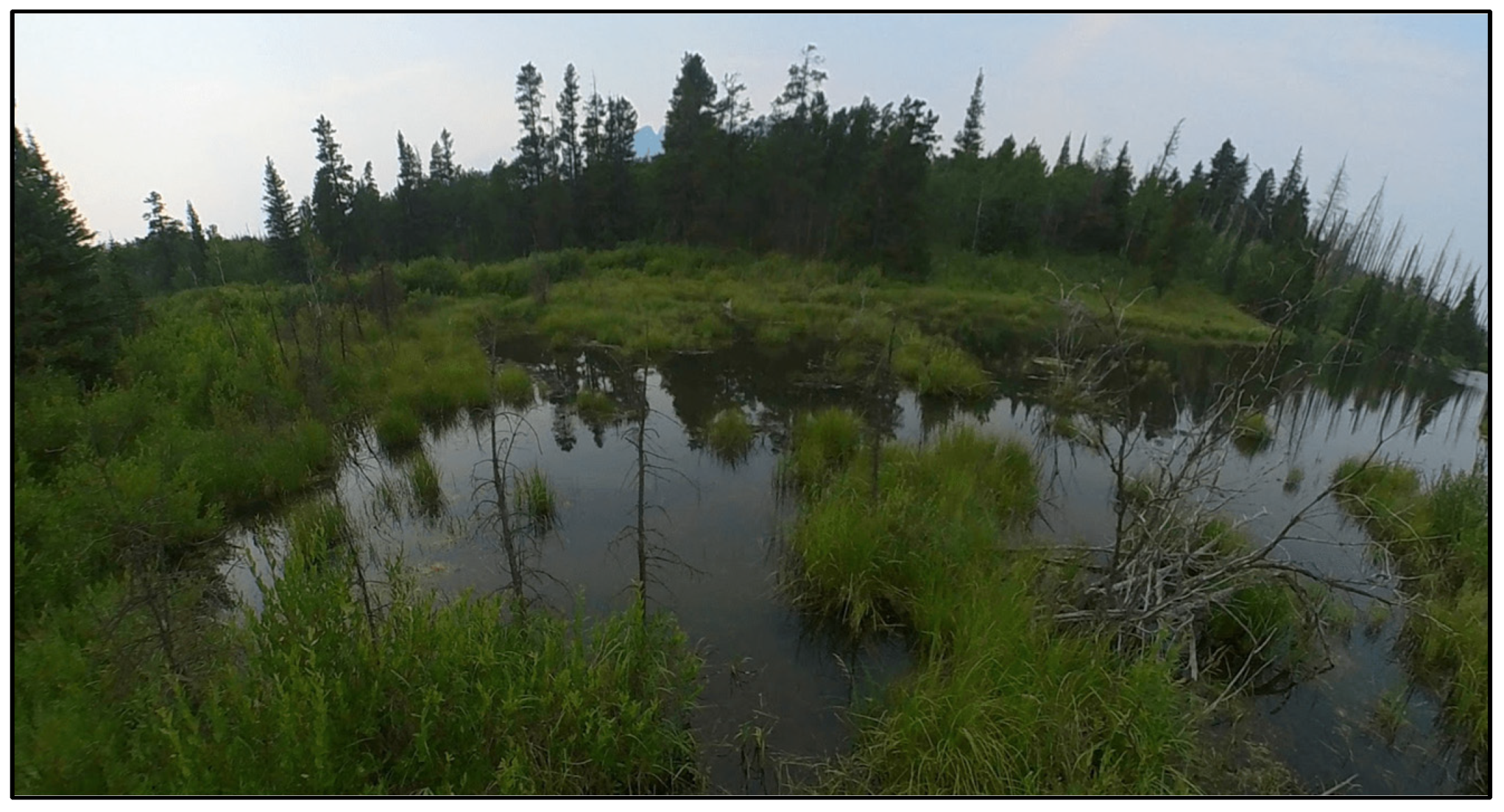
Site Description of Geographic Setting

The trailhead to the beaver pond sites described in this paper is located along the Red Eagle Lake Trail at the eastern end of St. Mary Lake (Figure 3). The trailhead is located at the Red Eagle Ranger Station (latitude 48.7384, longitude −113.4371, elevation of 1461.5 m). The mixed conifer forests of Douglas fir (Pseudotsuga menziesii) and lodgepole pine (Pinus contorta) transition into open meadows with intermittent groves of quaking aspen (Populus tremuloides) distributed throughout the area. Geology is bounded by tills with lower points of the topographic relief, designated as alluvium deposits by Holocene and Upper Pleistocene glaciers [30]. Tree snags and log remnants of the 2006 Red Eagle Fire are evident throughout the area. In Glacier National Park (GNP), the two primary types of beaver ponds are elongated, in-channel ponds (<0.4 ha) and floodplain ponds (several hectares in size) [31,32,33]. The smaller area in-channel ponds display sediment deposition and pond infilling that adjust water levels, resulting in flooding, dam breach, and pond abandonment [14,31,34]. However, the larger floodplain ponds are more stable and have been occupied and maintained by beaver populations for several decades. Beaver floodplain ponds in the Red Eagle Trail area represent the floodplain ponds (Figure 3).

3.3. TECCUPD Phase 2 Development, Step 3 (Capture): Resource Collection to Illustrate Beaver Influence on the Landscape

Information and resources were collected at the site-level scale (Table 2).

3.3.1. Site-Level Information and Resources

When weather conditions were clear and the viewshed was unobstructed, research team field participants hiked the trail to capture imagery of beaver signs and beaver-created physical features. Several 360-degree photographs are the foundation of the virtual, immersive experience and require specialized cameras. The field team used an Insta 360 1 R camera adapted for the dual-lens setup to capture the 360-degree photosphere. Macro photography capture tools included a smartphone with a Xenovo macro lens and LED light attachment. We examined the various sites for geomorphic variability, spatial characteristics, and patterns of the valley’s abandoned and active beaver ponds. We developed VLE content using information gathered from these observations from the 2021 field season and field notes collected during past field seasons (Table 2).
At various places along the Red Eagle Lake Trail, 360-degree photospheres, landscapes, and macro photography were collected. Scenes from Beaver Pond Loop include one intact pond that is narrower in area and couched in the enclosure of the mixed-conifer forest with visible snags lining the perimeter (Figure 4). A marshy-meadow buffer zone surrounds the pond and the beaver dam, with Salix establishment anchoring the dam, providing stability. The surrounding till mounds and forest limit the viewshed in this location; however, from the perspective of the beaver dam looking at the mountains, the peaks of Curly Bear, Divide, and White Calf Mountains are notable in the background despite the cloudy atmospheric conditions at the time of the 360-degree photograph capture. Also noteworthy is that the trail showing human movement through the area is visible with the tramping of the ground.
The second scene was taken downstream from the intact beaver pond, which was breached before 1995 (Figure 5). This viewshed is more expansive and open, and from the photographer’s vantage point, the relief of the Pleistocene moraine that bounds the riparian zone is visible. The spherical photograph looks directly across the abandoned beaver pond across the marshy floodplain in East Flattop, Otokomi, and Goat Mountains.
The stage of the plant successional sequence obscured many of the Castor signs and features. Therefore, archived resources from locations clear of vegetation were used in the VLE to show exemplars of Castor signs and patterns (Figure 6). Castor directly influences the land at the site, ecosystem, and landscape scales [12]. At the site level, observers detect their presence through tracks and signs they leave while going about their daily activities (Figure 6). Field research participants took wildlife tracking photos using a smartphone camera and a Sony RX10 IV. Team members followed Tracker Certifications North America specifications to retrieve signs of beaver, which are marked with red flags (Figure 6) [35].
Dams alter the water flow dynamics in the ponds, slowing water down until it becomes still and pools. They discharge kinetic energy in outlying directions from the main stream channel, spreading water out over the landscape (Figure 7). The VLE architects used sketches of the longitudinal pond sequence to illustrate modifications to hydrology and sedimentation (Figure 8 and Figure 9).
The longitudinal profile diagram effectively illustrates how the steps of branches that comprise the dam alter the hydrological process and reduce energy from the main stream, thus decreasing stream power that holds sediments in suspension (Figure 9). As sediment transport slows, the sediments settle to the bottom of the pond floor.
Mini-dams and logs can efficiently obstruct and trap large volumes of sediments efficiently [40]. Streamflow variation determines sedimentation trends, with high flows removing dams and yielding smaller sediment storage volumes [41]. Low-flow stream patterns are associated with more obstructions, which may produce a more positive sediment budget [41] (Figure 10 and Figure 11).

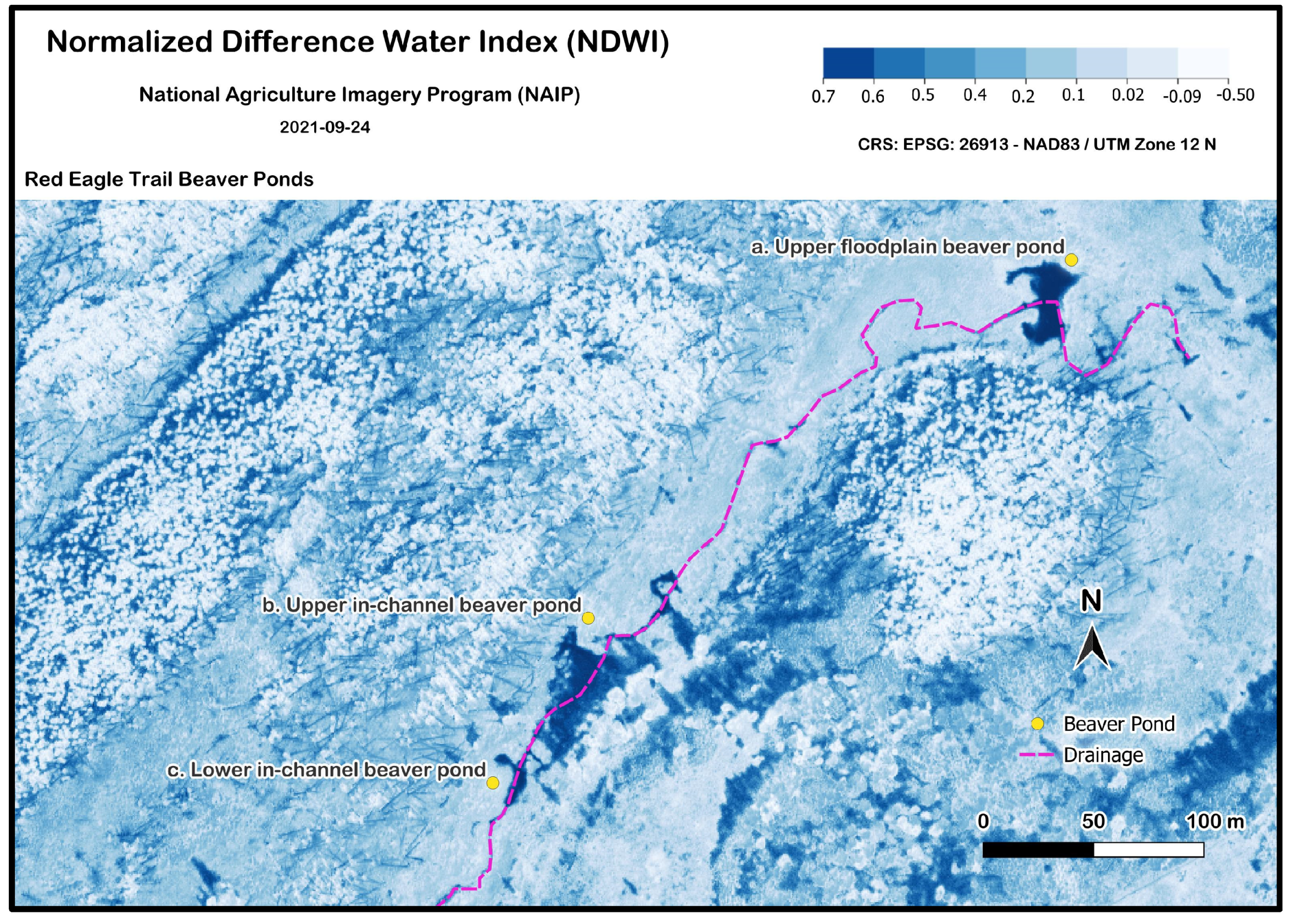
3.3.2. Landscape-Level Information and Resources

To show surface water at the landscape-level scale, we georeference low aerial imagery acquired through the United States Geological Survey’s Earth Resources Observation and Science Center (EROS) archive via Earth Explorer [45]. The national agriculture imagery program (NAIP) image for September 2021 had the highest cell resolution of 0.6 m, providing detailed spatial information in the St. Mary area. This image was selected for performing an NDWI using the open-source desktop application Quantum Geographic Information Systems (QGIS) version 3.34 (Figure 12). The index is a resource for interpreting surface water conditions (Table 3).

3.4. TECCUPD Phase 2 Development, Step 4 (Curate): VLE Development, TREE-PG-Chosen Constructs as Applied to the VRUI Orders

3.4.1. VRUI First-Order Photosphere

We used the VRUI curriculum planning tool’s first-order components aligned to each goal as a criterion for the design, development, and construction of the VLE [23]. For the VRUI first order, the first goal is to analyze the scene in the photosphere for interesting features in the viewshed when studying the scene of the Beaver Pond Loop. For example, we can see an easily identifiable beaver dam with branches visible and deposited sediments at the base [29]. We can also see the Salix firmly anchoring the dam, helping students make conversation and connections about why some beaver ponds may remain on the landscape and helping them explore assumptions about why other ponds may have disappeared over time (Figure 4). The background viewing zone of the visual setting allows the placement of information points as indicators of erosional and depositional processes in mountain environments with the movement of material (Figure 10) [29]. Leaving views of the more expansive floodplain with the drier, vegetated glacial till mounds. Leaving the scene uncluttered allows the user to take in the vistas to promote place attachment (a bond people have to a place) and topophilia (an affective feeling that connects a person with physical environments), potentially bonding the individual to the environment and others who share the experience [46]. Furthermore, this same scene shows the perceived distance from the high mountain to the lower valley environment, as well as the height of the Holocene and Upper Pleistocene glacial till designation (people in the background for scale to show the approximation of the 3–50 m high feature) [29,30]. Overall, the photospheres allow the visualization of a compelling, dynamic environment.

3.4.2. VRUI Second-Order Instructional Intervention

For the VRUI second order, we used Kelly et al.’s table 5 [23] and took the components’ goals to craft the instructional intervention (p. 64). The landscape architecture design brief, which encompasses a transdisciplinary approach to learning and assessment, was chosen to help students develop multiple lines of inquiry for taking the landscape problem of water insecurity and ideating multiple solutions for landscape water retention and maintenance. For the social strategy goal, the VLE contains a shared language of the landscape elements, their function, necessary tools, and design considerations to meet project requirements through a learning team discussion forum. Each team member can self-select their role or decide collectively within the group. They will conduct research in their chosen discipline and engage in role-playing activities to enhance their understanding and collaboration. Researching this place-based perspective of ecological engineering helps learners reconsider any misconceptions about the landscape hydrological system to reconcile human and natural ecological environments. Moreover, working as a team to tackle the multiple disciplines of physical geography, ecology, geomorphology, and landscape architecture for developing a landscape intervention, the learners come together as a team to build community, knowledge, and solutions with speed and creativity, drawing from their group’s strengths. That togetherness in knowledge building helps them refine their technical language use for precision in identifying design factors (features, process, cost, materials, and goals) and craft recommendations for landscape design to integrate natural wildlife and mimic artificial structures into planning for reconciling water issues. A project-based design can also incorporate the teacher or guest subject matter experts to evaluate the design brief for research steps that design for climate adaptation, landscape design principles grounded in science and nature, and provide meaningful feedback to enhance the learner’s reflection and experience for integrating their knowledge and skills into a more concrete learning experience. Finally, creating opportunities for learners to role-play in a professional activity allows them opportunities to try a career and identify early mentors that can engage them and motivate their learning.

3.4.3. VRUI Third-Order Contextual Application

For the VRUI third order, we used Kelly et al.’s table 6 [23] to create the contextual application of the VLE (p. 65). A project-based activity may allow students to engage in new skills and techniques as they apply them to local community issues while exploring climate adaptation strategies. Such transfer activities may also provide learners with avenues to cope with feelings about climate change as they develop actionable solutions that are meaningful for the health and well-being of their communities [47,48]. Further, presenting the project can allow for appropriate shifts of context and tone to practice the messaging and environmental communication to relay these solutions to a diverse audience. The landscape architecture design brief creates various reflective opportunities through the virtual site visit and initial lines of inquiry, which students translate into conceptual design, site analysis, landscape interventions, and conceptual renderings, along with recommendations for extending and integrating their knowledge. Students can use spatial patterns to predict changes in water distribution with changes in impoundments, plant distribution, and wetland expansion and contraction. Moreover, the simulations provide students with opportunities to explore system patterns and processes through data-driven visualizations and designs to guide decisions for the assignment.

3.5. TECCUPD Phase 2 Development, Step 5 (User): VLE Development

We used the TECCUPD workflow [22] table 4 as criteria for testing the curated and refined VLE (p. 13). We scrutinized the requirements associated with the learning objectives to ensure intentional design and development of the immersive experience took place. The VLE designers paid special attention to properly aligning the goals to the lesson parts for each VRUI order. For the criteria associated with photospheres, we examined the information point placement density in the scene to ensure the viewshed was uncluttered and the landscape was perceptible. Limiting text within the text window of the information point makes the experience more manageable for the user. We re-examined the choice of the photosphere to maintain quality control of the experience, which involves re-examining the digital resource collections for issues associated with the image capture (lighting, distortion, and visible details analysis). The choice of the best resource is a balance of these factors and the phenomena we hoped to describe and incorporate into the instructional intervention. We checked one final time to consider potential visual barriers to features of interest. We checked the weblink function for the criterion associated with the instructional intervention. Supporting lesson parts were reviewed to ensure technical language and jargon were defined and, if possible, associated with a visual example. For example, describing a beaver pond sequence includes imagery and figures to support visualization and the student’s construction of mental models. We examined the lesson sequence to ensure the information is relayed to the student with logical flow and appropriate leveling to support academic rigor.
To help the student contextualize place, VLE design choices should provide basic information about the location’s geography and explain why it is an iconic example of the experience. VLE designers described the tools and resources used for field collections and further development into indexes to clarify their significance in understanding the field trip topic and examples. The designers used developed assessments to connect students to learning objectives and illuminate how and why beavers, as ecological engineers, modify the landscape to suit their needs. Authentic assessments may help students explore beaver-inspired restoration strategies through design. Such authentic assessment provides multiple possibilities for contextual application, allowing the student to approach climate adaptation through role-play on a project scenario in which an ecologist, geomorphologist, and landscape architect are working on a city planning council to make recommendations to build infrastructure that maintains water presence on a city landscape. As part of a team working for human environmental climate adaptation, the learner can make the NDWI, interpret the index and water conditions across the terrain, and use that information to think through design choices of how the engineers adapted streams to improve water retention [49].

3.6. TECCUPD Phase 3 Development, Step 6 (Publish): VLE Development

To publish the field trip, we uploaded the curated and user-tested content (text, imagery, maps, and figures) into an application that is a repository containing a VR scene viewer. Any platform compatible with virtual reality (VR) can be used to view a 360-degree experience. For step 6 (publish), the content is licensed under “Creative Commons: Attribution-Noncommercial-ShareAlike 4.0 International”, permitting reuse and adaptation by others.

3.7. TECCUPD Phase 3 Development, Step 7 (Disseminate): VLE Development

Disseminating VLEs to the community is necessary to expand access to free, high-quality educational resources. Dissemination to education communities ensures that innovative teaching methods reach a broader audience, ultimately enhancing educational outcomes for diverse learners. Organizations focused on broadening access include the National Association of Geoscience Teachers and the Arizona Geographic Alliance (AzGA). Both organizations provide repositories for educators to access VLE without cost. These repositories offer resources like lesson plans aligned with educational standards, including VR-based content tagged as virtual field trips.

4. Part III: Evaluation of the VLE Using the TREE-PG Implementation Prioritization Scale (TIPS)

Educators can ensure that their VLE designs promote meaningful learning outcomes by adhering to TREE-PG objectives. We developed a tool that systematically assesses the alignment of VLE design practices with the key principles of TREE-PG to score the VLE. The TREE-PG implementation prioritization scale (TIPS) addresses this need by providing a comprehensive evaluation framework [50]. The TIPS measuring instrument helps assess the alignment of VLE design practices with TREE-PG principles. The educational theories emphasize dynamic engagement, theoretical fidelity, and practical application across diverse learning environments. Further, the TIPS scale captured the framework’s philosophical and pedagogical priorities. Foundational sources and seminal texts informed the integration of TREE-PG principles into the scale.
VLE architects’ use of the scale allows for review, iterative design and adjustment, and practical application of learning theory. The systematic scoring system and evaluation criteria confirm VLE’s presence and strength of theoretical constructs. TIPS emphasizes the fidelity of implementation and the importance of aligning practices with core TREE-PG objectives. By focusing on prioritization, TIPS provides a structured way to identify and measure the critical components of TREE-PG theory that contribute to successful implementation. It highlights areas where adjustments may be needed to align with theoretical principles and promotes consistent and high-quality application of TREE-PG methodologies across diverse settings [51]. The value of TIPS lies in its ability to enhance the effectiveness of VLE design practices by supporting designers with a deeper understanding of how educational theories can translate into meaningful outcomes to support students [52].
This study applies the theoretical and pedagogical approaches to the design components defined earlier as the VRUI orders. These components represent elements of VLE design that influence learning outcomes. The team evaluated each design component against TREE-PG principles to determine how they operationalize theoretical priorities within a VLE, which are translated into specific, actionable evaluation criteria for each design component.
To maintain the integrity of the evaluation process, the team carefully distinguished each design component’s focus. Given the emphasis on asynchronous online undergraduate VLE, the team explicitly designed TIPS to address the unique challenges of this modality. The adaptation of TREE-PG principles emphasizes clarity, accessibility, and the ability to promote meaningful engagement in asynchronous settings. To maintain the integrity of the evaluation process, the team distinguished each design component’s focus, removing redundancy across components and ensuring that the evaluation captured the unique contributions of each element without confounding results. For example, visual layout criteria were distinct from image-based design components. By focusing on prioritization, TIPS provides a structured way to identify and measure the critical components of TREE-PG theory that contribute to successful implementation. This measuring instrument ensures that course design aligns more closely with TREE-PG priorities and offers actionable, theory-based recommendations for VLE design. The TIPS methodology is a valuable resource for reflective practice and continuous improvement, empowering stakeholders to enhance the impact of TREE-PG frameworks in education.
The team created a standardized scoring system for the TIPS instrument to quantify alignment with TREE-PG priorities. Each design component was scored on a scale from 0 to 2. A score of 0 indicates that no evidence from the TREE-PG framework is present in the design component. A score of 1 indicates some evidence from the TREE-PG framework is present. A score of 2 indicates strong evidence from the TREE-PG framework in the design component.
An academic leadership team of three members (an education theorist, a biogeographer, and an aquatic ecologist) met to analyze and rate how well the VLE design and creation implemented theoretical constructs, using the TIPS measuring instrument. First, the team discussed each category of the suborders to clarify the exemplar of components and their criteria that would earn the total points. Then, the scoring took place. Scoring included note-taking of logic and rationale on why components of the VLE scored high, medium, and low. Each team member evaluated the VLE for the theoretical construct’s presence, averaged the results to determine whole number scores for each category, and documented the final scores.

5. Results

The results of the scores of the VLE components aligned to theory are reported in total and then by order subscale (Supplementary Materials). The total combined score for the ecosystem engineer VLE is 84 out of 144 total points (Table 4). For the core-order subscale that measures education theory as aligned to the learning objectives, the VLE score is 7 out of 18. The first-order subscale measures education theory aligned to the photosphere, and the VLE scored 29 out of 54. The second-order subscale, which measures education theory aligned to the instructional intervention, scored 35 out of 54. The third-order subscale, which measured education theory as aligned to contextual application, scored 13 out of 18.

6. Discussion

6.1. Closing the Theory-to-Practice Gap for the Natural Sciences with Virtual Reality-Enhanced Online Education

There is still a gap in theory-informed frameworks and models to develop and evaluate virtual field and place-based learning experiences and trips, with only 30% of recent studies noting educational theory and associated pedagogical approaches [53] (p. 938). We have sought to close the theory-to-practice gap with a methodological process [22], a theoretical framework [23,25], a planning tool to break down the components of education theory application [23], and a tool to evaluate and measure the implementation [50]. With declines in field-based education, the VR-field education community is growing but still in its infancy [54,55]. It is essential to have frameworks and tools to apply and analyze the prioritization of learning theory in a VLE that can guide and support development. These supporting resources can assist VR architects in creating more natural science experiences to support our learning community in directing the development, dissemination, and evaluation of VLEs to support their use for the broader learning community.

6.2. Key Findings in the Virtual Learning Experience Evaluation for Ecosystem Engineers

TIPS is a structured tool for systematically evaluating how well VLEs align with key components of the TREE-PG framework, which aims to improve educational outcomes. The results show that different components of the VLE applied theoretical constructs with varying degrees of success.
The VRUI core-order design components for the VLE scored 7 out of 18, reflecting challenges in effectively applying multiple learning theories. For this order, the VLE excelled in using conceptual change theory, sense of place, and spatial thinking. This intense application of these theories supports student engagement with scientific concepts, real-world ecosystems, and spatial reasoning.
The VRUI first-order design components for the VLE scored 29 out of 54, reflecting a strong integration of theoretical constructs in certain areas but highlighting opportunities for improvement in others. This component involves 360-degree photography, including static and dynamic images and data visualizations. The VRUI first-order design components strongly align with conceptual change theory, academic self-concept, situated cognition, sense of place, and spatial thinking. Using images and data visualizations promotes cognitive engagement, confidence in working with these concepts, contextualized learning, place-based understanding, and spatial reasoning. Areas where alignment is weak suggest that the VLE can be further refined to expand constructs for social constructivism, experiential learning, systemic functional linguistics, and ludic pedagogy.
The VRUI second-order for the VLE scored 35 out of 54 for the instructional intervention. The score indicated a moderate to strong integration of theoretical constructs but highlighted improvement areas. The components are advisory language, resource text, and assessment, providing a more complex framework and flexibility for VLE architects to incorporate learning theories creatively. Academic self-concept and sense of place scored high, while conceptual change theory and social constructivism scored low. Academic self-concept scores were strong as the advisory language supports students’ confidence by positioning them as subject matter experts. Students apply their knowledge to solve real-world problems, such as using restoration ecology to address community water issues. Sense of place scored high for this order as academic content is linked to mountain and floodplain ecosystems, allowing students to apply knowledge in context and real-world relevance. Conceptual change theory scored lower in this order as the VLE did not fully support students identifying and addressing their misconceptions based on the limited opportunities for reflection. The integration of social constructivism theoretical constructs is low in this order because there are limited opportunities for co-constructed learning between peers.
The VRUI third-order design components for the VLE contextual application scored 13 out of 18. For this order, the VLE scored high in conceptual change, systemic functional linguistics, situated cognition, spatial thinking, and sense of place. The presence and strength of using these theories in development indicate knowledge transfer, problem-solving, and real-world application. The theories that were present but not as strong were social constructivism, academic self-concept, and experiential learning, which suggest collaboration opportunities, building confidence, and active engagement in problem-solving. ludic pedagogy scored low, illustrating an absence of playfulness through more creative and exploratory learning activities that might support deeper engagement.
Overall, with all components combined, the VLE scored high in specific areas of the TREE-PG framework, such as conceptual change theory, sense of place, and spatial thinking. The score was high for conceptual change theory. The core-suborder learning objectives are designed to engage with students’ prior knowledge to help restructure that knowledge towards scientific accuracy. Static images support the re-evaluation of their understanding of beaver-modified ecosystems in glacial-formed environments and are used to challenge their assumptions about these environments. The score is weaker in the dynamic images as the manipulation of the perspective is limited by current technology, though incorporating more tactile elements using hand controllers with a 3D Geographic Information System into virtual environments has the potential to resolve such weaknesses [56]. Such a solution might alleviate the limited scaffolding to support the concept revision process for the student. Sense of place is supported as the VLE supports exploration and interaction of the beaver and glacier-modified environments. Visuals support students’ comprehension of both mechanistic and systems-level thinking for biogeography [57]. Students are encouraged to apply the newly acquired knowledge around place to solve challenging environmental scenarios. There is a limitation in the visuals; they do not support the dynamic nature of landscape change with seasons and over time. Spatial thinking scores high as the goal is to aid students’ understanding of spatial patterns and processes. Data visualizations are incorporated to illustrate physical geography, and such illustrations are followed through to assessment. However, scoring is weak because students do not practice the scientific language that can guide them through the processes that form the identifiable patterns.
However, the leadership team scored the VLE lower when applying multiple learning theories like social constructivism, systemic functional linguistics, experiential learning, and ludic pedagogy. The evaluation highlighted the limitations of developing social constructivist principles in asynchronous online learning environments. Though the assessment requires students to participate in an online discussion forum to come together to problem-solve the issues found in the landscape design brief, there is still insufficient engagement to meet the criteria of the theoretical principle as outlined in TIPS. For systemic functional linguistics, the VLE score is lower because of all the data visualization in which technical language is limited. The VLE does not have students use the specialized language to interpret the VLE until the assessment. Students passively engage with the terms but are not actively using them within the virtual environment.
Furthermore, though the online activity requires students to enter multiple 360-degree images to learn more about beaver-modified environments, real-world challenges are missing from the learning objectives, resource text, and visuals. Students only engage in experiential learning in the assessment to apply their learning to new challenges as introduced in the advisory language of the instructions. Finally, ludic pedagogy requires the student to engage with playfulness and have fun. For the assessment, students role-play experts in specific disciplines engaged in restoration ecology designs for their community to maintain water retention and security using the ecosystem engineers as a natural resource for their work. However, the learning objectives do not require risk-taking through playful tasks, which may impact motivation and limit their creativity in problem-solving for the assessment.

6.3. Overcoming Challenges Through Iterative Design

There are challenges for VLE architects to overcome when developing more complex education theory-informed VLEs [58,59]. Making one of these VLEs is a commitment in terms of time, resources, expertise, and cognitive load for development [60]. There is utility in using ecological engineers and climate adaptation to help students develop career-relevant skills for regenerative environmental interventions [61,62]. One realization is that many educators may have a resource archive that could be adapted for VLEs by collecting a few more resources in 360-degree views to enliven classrooms. So, this process provides a mechanism for using existing resources and enhancing them to maximize learning using these frameworks. Using the previous goals of the frameworks to develop checklists to guide development is one strategy to maintain a strong theory-to-practice design. Framework goals adapted to checklists can reduce the cognitive load so that best practices are met; however, a larger team for support can reduce the cognitive strain and provide more resources required to produce one. We have found that for the ecological engineers and climate adaptation immersive experiences for science education, we needed students to role-play as ideal team members in the following interdisciplinary fields: geology, biogeography, geomorphology, ecology, wildlife tracking, and landscape architecture. The subject matter expertise of these individuals informs the virtual realm that supports learning. Using this integration of theoretical and methodological frameworks supports VLE designers and architects with a process to take previous resource collections, update them, and align them with current standards, best practices, and learning theory, which fills the gap in the absence of theory-informed lessons for VR and education [58,59].

6.4. Limitations of Siloed Artificial Intelligence and Workarounds

A limitation of AI is output needs to be examined for errors by a subject matter expert. AI can help educators save time and remove barriers for rapid lesson development in education [63]. It is important to explore the idea of a siloed AI system that allows teachers only to search materials that have been vetted and ready to use in their classroom. Uploading lessons available to Creative Commons repositories provides a more rapid analysis of what is inside the lesson, supporting files, and activities. Such analysis can pull verbiage adjusted for grade levels and standards, allowing for re-mixing and adaptation of activities, outcomes, purpose, and assessments. With all the resources available to teachers, it is easy to spend time searching and examining different lesson plans and resources. Using a siloed AI, like Strabo, we hope to help educators recapture time, a valuable resource in education.

7. Conclusions

The immersive VLE developed in this study communicates the complexity of the interdisciplinary lesson for landscape modification in mountain valley ecosystems by beaver activity adapted to virtual reality (VR). It highlights the importance of zoogeomorphic agents for climate adaptation planning and interventions. By merging theory-informed frameworks and tools for virtual reality with traditional field-based learning, we have created a new paradigm in science education that provides a more empowered, inclusive, and engaging learning experience in the classroom, making these environments and the lessons they provide more accessible. This approach can be applied to other zoogeomorphologic topics and disciplines to enhance learner engagement with animal-influenced landforms while promoting a deeper appreciation for the beaver as an actor in the system, one that is a solution in creating and maintaining sustainable and regenerative environments.
The checklists developed from the goals of the frameworks (TECCUPD, TREE-PG, VRUI, and TIPS) can support educators by providing a structured, step-by-step approach to creating comprehensive and engaging VLEs. These checklists ensure that the learning objectives, content alignment, pedagogical strategies, and technology integration are considered throughout the VLE development process. By following these checklists, educators can streamline a more complex workflow while reducing cognitive strain. Moreover, it allows educators to capitalize on more legacy products of past lessons and incorporate them into more current, dynamic curricula.
TIPS provides a framework for evaluation of theoretical implementation and where there may be areas for improvement to support student learning. It helps identify and measure the theoretical implementation of key components in each category that drive successful learning outcomes. VLEs that score low indicate areas where adjustments may be necessary to ensure that the TREE-PG framework is applied effectively and consistently across diverse educational settings. TIPS promotes the high-quality and consistent application of the TREE-PG framework to ensure that practices align with the core objectives of the approach. The TIPS scale is a tool to measure the fidelity of implementation of TREE-PG theoretical constructs in VLE design and architecture. Aligning this learning theory to the VLE may lead to meaningful outcomes. As both a guide for reflective practice and a tool for continuous improvement, TIPS design guides and supports educators in strengthening the use of learning theory in VR-educational contexts. Prioritization will mean different things for different educators’ purposes.
Finally, siloed AI holds promise as it removes the superfluous aspects of the Internet that obscure learning and create misconceptions. Suppose national councils and organizations that support education focus on developing and maintaining these types of archives and repositories for complex and rich VLEs. In that case, educators can easily incorporate this high-quality, theory-informed, place-based content into curricula.
These virtual, immersive experiences can ignite field-based knowledge and skills in the VR-enhanced classroom for the asynchronous, online natural science class to help students envision complex environmental topics, ideate challenges and solutions, and potentially take therapeutic action for the environment and the learners themselves. Such VR-compatible instructional assets may address the limited number of place-based and field-based experiences for the natural sciences and be the valued resources educators need to save energy and time. We reiterate to our fellow VR architects and VLE designers that these theory-informed educational lessons are valuable, and sharing our work broadly can help educators optimize their time and energy, potentially optimizing the learning experience and performance within the classroom.

Supplementary Materials

The following supporting information can be downloaded at: https://www.mdpi.com/article/10.3390/wild2020009/s1, File S1: TREE-PG Implementation Prioritization Scale (TIPS). The Field Trip: Field Trip: Beaver Ponds Along the Red Eagle Trail, Glacier National Park, Montana, USA can be accessed at https://geoepic.app/lessons/field-trip-beaver-ponds-along-the-red-eagle-trail-glacier-national-park-montana-usa (accessed on 10 March 2025) [29]. The TREE-PG Implementation Prioritization Scale (TIPS) is found at http://dx.doi.org/10.13140/RG.2.2.33230.57922 (accessed on 10 March 2025) [50].

Author Contributions

Conceptualization, D.G., J.G., J.K., N.V.C. and T.J.O.; methodology, D.G. and J.K.; software, J.G.; validation; D.G., J.K. and N.V.C.; formal analysis, A.M., D.R.B., D.G., J.K. and N.V.C.; investigation, A.H., A.M., D.G., E.G. and J.K.; resources, A.H., D.G., E.G., J.K. and K.G.; data curation, D.G.; writing—original draft preparation, A.M., D.R.B., D.G., J.K. and H.L.M.; writing—review and editing, A.H., A.M., D.G., J.G., J.K. and N.V.C.; visualization, A.H., D.R.B., D.G. and E.G.; supervision, D.G.; project administration, D.G., J.K. and N.V.C. All authors have read and agreed to the published version of the manuscript.

Funding

This research received no external funding.

Institutional Review Board Statement

Not applicable.

Informed Consent Statement

Not applicable.

Data Availability Statement

The data presented in this study are available from the corresponding author upon request.

Acknowledgments

We would like to thank the National Park Service scientists and staff for their logistical and permitting support for fieldwork conducted in Glacier National Park.

Conflicts of Interest

Author Johan Gielstra was employed by the company Sensus Loci LLC. The remaining authors declare that the research was conducted in the absence of any commercial or financial relationships that could be construed as a potential conflict of interest.

References

  1. Pollock, M.M.; Lewallen, G.M.; Woodruff, K.; Jordan, C.E.; Castro, J.M. The Beaver Restoration Guidebook: Working with Beaver to Restore Streams, Wetlands, and Floodplains; United States Fish and Wildlife Service: Washington, DC, USA, 2023. [Google Scholar]
  2. Chapter 3. Impacts of 1.5 °C Global Warming on Natural and Human Systems. In Special Report: Global Warming of 1.5 °C; International Panel on Climate Change: Geneva, Switzerland, 2018.
  3. Butler, D.R.; Anzah, F.; Goff, P.D.; Villa, J. Zoogeomorphology and Resilience Theory. Geomorphology 2018, 305, 154–162. [Google Scholar] [CrossRef]
  4. Brazier, R.E.; Puttock, A.; Graham, H.A.; Auster, R.E.; Davies, K.H.; Brown, C.M.L. Beaver: Nature’s Ecosystem Engineers. WIREs Water 2021, 8, e1494. [Google Scholar] [CrossRef] [PubMed]
  5. Westbrook, C.J.; Cooper, D.J.; Baker, B.W. Beaver Dams and Overbank Floods Influence Groundwater–Surface Water Interactions of a Rocky Mountain Riparian Area. Water Resour. Res. 2006, 42, 2005WR004560. [Google Scholar] [CrossRef]
  6. Hansson, L.; Brönmark, C.; Anders Nilsson, P.; Åbjörnsson, K. Conflicting Demands on Wetland Ecosystem Services: Nutrient Retention, Biodiversity or Both? Freshw. Biol. 2005, 50, 705–714. [Google Scholar] [CrossRef]
  7. Goldfarb, B. Eager: The Surprising, Secret Life of Beavers and Why They Matter; Chelsea Publishing: New York, NY, USA, 2018. [Google Scholar]
  8. de Vette, K. Filling the Skills Gap. International Water Association. The Source Magazine. 3 September 2024. Available online: https://thesourcemagazine.org/filling-the-skills-gap/ (accessed on 23 January 2025).
  9. United States Environmental Protection Agency. Adaptation Actions for Water Utilities. Climate Change Adaptation Resource Center. Available online: https://www.epa.gov/arc-x/adaptation-actions-water-utilities (accessed on 23 January 2025).
  10. Dittbrenner, B.J.; Pollock, M.M.; Schilling, J.W.; Olden, J.D.; Lawler, J.J.; Torgersen, C.E. Modeling Intrinsic Potential for Beaver (Castor canadensis) Habitat to Inform Restoration and Climate Change Adaptation. PLoS ONE 2018, 13, e0192538. [Google Scholar] [CrossRef]
  11. Dittbrenner, B.J.; Schilling, J.W.; Torgersen, C.E.; Lawler, J.J. Relocated Beaver Can Increase Water Storage and Decrease Stream Temperature in Headwater Streams. Ecosphere 2022, 13, e4168. [Google Scholar] [CrossRef]
  12. Hood, G.A.; Larson, D.G. Ecological Engineering and Aquatic Connectivity: A New Perspective from Beaver-modified Wetlands. Freshw. Biol. 2015, 60, 198–208. [Google Scholar] [CrossRef]
  13. Gurnell, A.M. The Hydrogeomorphological Effects of Beaver Dam-Building Activity. Prog. Phys. Geogr. Earth Environ. 1998, 22, 167–189. [Google Scholar] [CrossRef]
  14. Butler, D.R.; Malanson, G.P. The Geomorphic Influences of Beaver Dams and Failures of Beaver Dams. Geomorphology 2005, 71, 48–60. [Google Scholar] [CrossRef]
  15. Scamardo, J.E.; Marshall, S.; Wohl, E. Estimating Widespread Beaver Dam Loss: Habitat Decline and Surface Storage Loss at a Regional Scale. Ecosphere 2022, 13, e3962. [Google Scholar] [CrossRef]
  16. Pollock, M.M.; Beechie, T.J.; Wheaton, J.M.; Jordan, C.E.; Bouwes, N.; Weber, N.; Volk, C. Using Beaver Dams to Restore Incised Stream Ecosystems. BioScience 2014, 64, 279–290. [Google Scholar] [CrossRef]
  17. Vasiliev, D. The Role of Biodiversity in Ecosystem Resilience. IOP Conf. Ser. Earth Environ. Sci. 2022, 1072, 012012. [Google Scholar] [CrossRef]
  18. Ripple, W.J.; Beschta, R.L. Trophic Cascades in Yellowstone: The First 15 years after Wolf Reintroduction. Biol. Conserv. 2012, 145, 205–213. [Google Scholar] [CrossRef]
  19. Radianti, J.; Majchrzak, T.A.; Fromm, J.; Wohlgenannt, I. A Systematic Review of Immersive Virtual Reality Applications for Higher Education: Design Elements, Lessons Learned, and Research Agenda. Comput. Educ. 2020, 147, 103778. [Google Scholar] [CrossRef]
  20. Amarulloh, R.R.; Aswie, V. Bibliometric Analysis of Virtual Reality in Science Education over the Three Decades (1993–2023). Sci. Educ. Int. 2024, 35, 270–280. [Google Scholar] [CrossRef]
  21. Arif, L.S.; Soemantri, D.; Findyartini, A. Needs Analysis of Virtual Reality Implementation in Indonesian Medical Curricula: A Qualitative Study. Educ. Med. J. 2024, 16, 59–75. [Google Scholar] [CrossRef]
  22. Gielstra, D.; Moorman, L.; Kelly, J.; Schulze, U.; Resler, L.M.; Cerveny, N.V.; Gielstra, J.; Bryant, A.; Ramsey, S.; Butler, D.R. Designing Virtual Pathways for Exploring Glacial Landscapes of Glacier National Park, Montana, USA for Physical Geography Education. Educ. Sci. 2024, 14, 272. [Google Scholar] [CrossRef]
  23. Kelly, J.; Gielstra, D.; Moorman, L.; Schulze, U.; Cerveny, N.V.; Gielstra, J.; Swihart, R.J.; Ramsey, S.; Oberding, T.J.; Butler, D.R.; et al. Crafting Glacial Narratives: Virtual Exploration of Alpine Glacial and Periglacial Features in Preston Park, Glacier National Park, Montana, USA. Glacies 2024, 1, 57–79. [Google Scholar] [CrossRef]
  24. Kelly, J.; Edgcomb, A.; Bruno, J.; Gordon, C.; Vahid, F. Theory to Practice: Reducing Student Attrition in Online Undergraduate Math. Int. J. Res. Educ. Sci. 2022, 8, 187–206. [Google Scholar] [CrossRef]
  25. Kelly, J. Translating Research in Environmental Education (TREE) Conceptual Framework. 2021. Available online: https://www.researchgate.net/publication/375958199_Translating_Research_in_Environmental_Education_TREE_Conceptual_Framework?channel=doi&linkId=656502d4b1398a779dbe236c&showFulltext=true (accessed on 10 March 2025).
  26. GeoCivics Resources 2024. Available online: https://wicket.org/civics-curriculum/ (accessed on 10 March 2025).
  27. Es, S.; James, J.; Espinosa-Anke, L.; Schockaert, S. RAGAS: Automated Evaluation of Retrieval Augmented Generation 2023. Available online: https://arxiv.org/abs/2309.15217 (accessed on 28 July 2024).
  28. Gielstra, J. Strabo AI 2024. Available online: https://strabo.chromis.ddns.net (accessed on 10 March 2025).
  29. Gielstra, D.; Butler, D.R.; Markevich, A.; Hunkins, A.; Gielstra, E.; Gielstra, J.; Cerveny, N.V. GeoEPIC. 2024. Available online: https://geoepic.app/lessons/field-trip-beaver-ponds-along-the-red-eagle-trail-glacier-national-park-montana-usa (accessed on 10 March 2025).
  30. Whipple, J.W. Geologic Map of Glacier National Park; U.S. Geological Survey: Missoula, MT, USA, 1992. [Google Scholar]
  31. Butler, D.R. Characteristics of Beaver Ponds on Deltas in a Mountain Environment. Earth Surf. Process. Landf. 2012, 37, 876–882. [Google Scholar] [CrossRef]
  32. Collen, P.; Gibson, R.J. The General Ecology of Beavers (Castor spp.), as Related to Their Influence on Stream Ecosystems and Riparian Habitats, and the Subsequent Effects on Fish—A Review. Rev. Fish Biol. Fish. 2000, 10, 439–461. [Google Scholar] [CrossRef]
  33. Zavyalov, N.A. Beavers (Castor Fiber and Castor canadensis), the Founders of Habitats and Phytophages. Biol. Bull. Rev. 2014, 4, 157–180. [Google Scholar] [CrossRef]
  34. Meetenmeyer, R.K.; Butler, D.R. Temporal and Spatial Changes in Beaver Pond Locations, Eastern Glacier National Park, Montana, USA. Geogr. Bull. 1995, 37, 97–104. [Google Scholar]
  35. Tracker Certification Tacker Certifications. Cyber Tracker North America. Available online: https://trackercertification.com/ (accessed on 11 November 2024).
  36. Platz, J.E. CHOICE: Current Reviews for Academic Libraries; American Library Association CHOICE: Chicago, IL, USA, 2012; p. 1678. [Google Scholar]
  37. Mott, C.L.; Cy, L.; Bloomquist, C.K.; Nielsen, K. Within-Lodge Interactions between Two Ecosystem Engineers, Beavers (Castor canadensis) and Muskrats (Ondatra zibethicus). Behavior 2013, 150, 1325–1344. [Google Scholar]
  38. Tye, S.P.; Geluso, K.; Harner, M.J.; Siepielski, A.M.; Forsberg, M.L.; Buckley, E.M.B.; Dale, J.S. One House Is a Home for Many: Temporal Partitioning of Vertebrates on an American Beaver Lodge. Am. Midl. Nat. 2021, 185, 229–240. [Google Scholar]
  39. Dugmore, A.R. The Romance of the Beaver: Being the History of the Beaver in the Western Hemisphere; J.B. Lippincott Company: Philadelphia, PA, USA, 1914. [Google Scholar]
  40. Megahan, W.F. Channel Sediment Storage behind Obstructions in Forested Drainage Basins Draining the Granitic Bedrock of the Idaho Batholith; Sediment Budgets and Routing in Forested Drainage Basins; USDA Forest Service: Portland, OR, USA, 1982; pp. 114–121. [Google Scholar]
  41. Gordon, N.D.; McMahon, T.A.; Finlayson, B.L. Stream Hydrology: An Introduction for Ecologists; John Wiley and Sons: Chichester, UK, 1992. [Google Scholar]
  42. Butler, D.R. The Daily Photo for Saturday, November 24. In Zoogeomorphology Daily—Zoogeomorphology Is Best Geomorphology!; 2020. Available online: https://www.facebook.com/photo/?fbid=10157691971971709&set=gm.1016671778853504 (accessed on 29 September 2024).
  43. Butler, D.R. The Daily Photo for Saturday, November 28. In Zoogeomorphology Daily—Zoogeomorphology Is Best Geomorphology!; 2020. Available online: https://www.facebook.com/photo/?fbid=10157699454671709&set=gm.1019655608555121 (accessed on 29 September 2024).
  44. Butler, D.R. The Daily Photo for Sunday, January 10. In Zoogeomorphology Daily—Zoogeomorphology Is Best Geomorphology! 2020; Available online: https://www.facebook.com/photo/?fbid=10157787693401709&set=gm.1048909895629692 (accessed on 29 September 2024).
  45. United States Geological Survey USGS EROS Archive: Aerial Photography National Agriculture Imagery Program (NAIP). Available online: https://www.usgs.gov/centers/eros/science/usgs-eros-archive-aerial-photography-national-agriculture-imagery-program-naip (accessed on 11 November 2024).
  46. Trimbach, D.J.; Fleming, W.; Biedenweg, K. Whose Puget Sound?: Examining Place Attachment, Residency, and Stewardship in the Puget Sound Region. Geogr. Rev. 2022, 112, 46–65. [Google Scholar] [CrossRef]
  47. Elisa, W. Engineering Students’ Affective Response to Climate Change: Toward a Pedagogy of “Critical Hope” and Praxis. Teach. Ethics 2022, 22, 1–15. [Google Scholar] [CrossRef]
  48. Jacobs, M.; Memmer, K. Addressing the Climate Crisis through Science and Art: The Value of Interdisciplinary and Intergenerational Team Teaching. Honors Pract. 2024, 20, 215–219. [Google Scholar]
  49. Wohl, E.; Scott, D.N.; Yochum, S.E. Managing for Large Wood and Beaver Dams in Stream Corridors; U.S. Department of Agriculture, Forest Service; Rocky Mountain Research Station: Fort Collins, CO, USA, 2019; p. 137. [Google Scholar]
  50. Kelly, J.; Gielstra, D.A.; Oberding, T.J. TREE-PG Implementation Prioritization Scale (TIPS): Virtual Learning Experience (VLE) Scale for the Fidelity of Implementation of Translating Research in Environmental Education for Physical Geography Framework (TREE-PG). 2025. Available online: https://www.researchgate.net/publication/389944314_TREE-PG_Implementation_Prioritization_Scale_TIPS_Virtual_Learning_Experience_VLE_Scale_for_the_Fidelity_of_Implementation_of_Translating_Research_in_Environmental_Education_for_Physical_Geography_Fram?channel=doi&linkId=67d9c8bae62c604a0ddddec6&showFulltext=true (accessed on 10 March 2025).
  51. Kaya, D.; Kutluca, T.; Dağhan, G. Transforming Education with Augmented Reality, Metaverse and Virtual Reality Technologies in the 21st Century. Hacet. Univ. J. Educ. 2023, 38, 470–497. [Google Scholar] [CrossRef]
  52. Wehrmann, F.; Zender, R. Inclusive Virtual Reality Learning: Review and “Best-Fit” Framework for Universal Learning. Electron. J. E-Learn. 2024, 22, 74–89. [Google Scholar] [CrossRef]
  53. Marougkas, A.; Troussas, C.; Krouska, A.; Sgouropoulou, C. Virtual reality in education: A review of learning theories, approaches and methodologies for the last decade. Electronics 2023, 12, 2832. [Google Scholar] [CrossRef]
  54. Czimre, K.; Teperics, K.; Molnár, E.; Kapusi, J.; Saidi, I.; Gusman, D.; Bujdosó, G. Potentials in Using VR for Facilitating Geography Teaching in Classrooms: A Systematic Review. ISPRS Int. J. Geo-Inf. 2024, 13, 332. [Google Scholar] [CrossRef]
  55. Minocha, S.; Tilling, S.; Tudor, A. Role of Virtual Reality in Geography and Science Fieldwork Education. Knowledge Exchange Seminar Series, Learning from New Technology. 2018. Available online: https://kess.org.uk/2018/05/02/prof-shailey-minocha-dr-ana-despina-tudor-ou-role-virtual-reality-geography-science-fieldwork-education/ (accessed on 10 March 2025).
  56. Moore, A.; Daniel, B.; Leonard, G.; Regenbrecht, H.; Rodda, J.; Baker, L.; Ryan, R.; Mills, S. Comparative Usability of an Augmented Reality Sandtable and 3D GIS for Education. Int. J. Geogr. Inf. Sci. 2020, 34, 229–250. [Google Scholar] [CrossRef]
  57. Lowell, V.L.; Yan, W. Applying Systems Thinking for Designing Immersive Virtual Reality Learning Experiences in Education. TechTrends 2024, 68, 149–160. [Google Scholar] [CrossRef]
  58. Eutsler, L.; Long, C.S. Don’t Put the Cart Before the Horse: Self-Study on Using VR in Education. TechTrends 2024, 68, 136–148. [Google Scholar] [CrossRef]
  59. Fowler, C. Virtual Reality and Learning: Where Is the Pedagogy? Br. J. Educ. Technol. 2015, 46, 412–422. [Google Scholar] [CrossRef]
  60. Cook, M.; Lischer-Katz, Z.; Hall, N.; Hardesty, J.; Johnson, J.; McDonald, R.; Carlisle, T. Challenges and Strategies for Educational Virtual Reality: Results of an Expert-Led Forum on 3D/VR Technologies Across Academic Institutions. Inf. Technol. Libr. 2019, 38, 25–48. [Google Scholar] [CrossRef]
  61. Beavers Offer Solution to Climate Change. 2008. Available online: https://www.npr.org/2008/05/03/90160624/beavers-offer-solution-to-climate-change (accessed on 11 November 2024).
  62. Toner, J.; Desha, C.; Reis, K.; Hes, D.; Hayes, S. Integrating Ecological Knowledge into Regenerative Design: A Rapid Practice Review. Sustainability 2023, 15, 13271. [Google Scholar] [CrossRef]
  63. U.S. Department of Education, Office of Educational Technology. Artificial Intelligence and the Future of Teaching and Learning: Insights and Recommendations. Washington, DC, USA. 2023. Available online: https://www.ed.gov/sites/ed/files/documents/ai-report/ai-report.pdf (accessed on 10 March 2025).
Figure 1. A screenshot of Strabo AI’s Zoogeomorphology workspace showing VLE architect prompts to create and refine educational goals for VLE development [26].
Wild 02 00009 g001
Figure 2. A screenshot of Strabo AI’s Zoogeomorphology workspace showing prompts to create learning objectives that are more detailed and specific for a lesson using the discipline of geomorphology and for landscape architecture for VLE development [28].
Wild 02 00009 g002
Figure 3. Field sites for the beaver pond VLE instructional assets.
Wild 02 00009 g003
Figure 4. Intact beaver dam on the Beaver Pond, Red Eagle Lake Trail, Glacier National Park (Extracted from 360-photograph taken by Johan Gielstra).
Wild 02 00009 g004
Figure 5. Abandoned floodplain beaver pond on the Beaver Pond Loop, Red Eagle Lake Trail, Glacier National Park (Extracted from 360-photograph taken by Johan Gielstra).
Wild 02 00009 g005
Figure 6. Various tracks and signs of beavers (Castor): (a) alternating hind feet, which destroy the tracks of the smaller front feet; though the hind foot has five toes, only the outer three usually show up in the hind track (photo taken along the Rio Grande River at Buckman Rd., semi-arid climate at elevation 1676 m). (b) Webbing between toes to assist movement with speed and agility underwater. Tracks may be erased by the beaver’s flat tail dragging over them (photo taken along the Rio Grande River at Buckman Rd., elevation 1676 m). (c) Evidence of dragging and beaver trails, typically indicating dam-building materials or food movement. Dragging cut branches to water creates distinct groove marks in the substrate on either side of the flat tail drag (photo taken along the Rio Grande near Albuquerque, NM, semi-arid climate at 1524 m elevation). (d) Evidence of past canal excavation can be 200–300 m long (photo taken at Los Potreros, Santa Fe County, with a semi-arid climate located on a sloping alluvial floodplain at 1828 m elevation) [12]. (e) Root foraging at high water levels creates a shelf along the river or pond along river or pond edges (photo taken along the Rio Grande near Albuquerque, NM, the semi-arid climate at 1828 m elevation) [36]. (f) When water levels drop, beaver burrows are exposed and, when abandoned, serve as unique habitats for use by other species (photo taken along the Rio Grande near Albuquerque, NM, semi-arid climate at 1524 m feet elevation) [37,38]. (g) To access branches, beavers will fell large trees, altering the composition of surrounding vegetation over time (photo taken along the Rio Grande near Albuquerque, NM, semi-arid climate at 1524 m elevation) [34]. (h) Scent mounds are flagged, marked by exuded dark Castor secretions along the water’s edge to mark territory. These often mark the edges of a beaver’s territory (photo taken along the Rio Grande near Albuquerque, NM, semi-arid climate at 1524 m elevation) [36]. (All photographs by Ann Hunkins).
Wild 02 00009 g006
Figure 7. The formation of a chain, or sequence, of linked beaver dams and ponds occurs along the plane-view longitudinal profile of a stream. The large arrows indicate forward water movement from the main stream channel with outward spread as the water slows [39] (Illustration by Ella Gielstra).
Wild 02 00009 g007
Figure 8. The formation of a pond sequence of linked beaver dams along the longitudinal profile of a stream. The cross-section drawings show the stair-step nature along the stream to regulate water inflows and outflows for more strategic capture and water level adjustments [39] (Illustration by Ella Gielstra).
Wild 02 00009 g008
Figure 9. The arrows indicate the energy deflection off the dam with larger particles falling out of suspension with reduced stream power leading to sediment deposition, accumulation, and infilling [39] (Illustration by Ella Gielstra).
Wild 02 00009 g009
Figure 10. These photographs are taken of the same small beaver pond just off the Red Eagle Lake Trail at two different periods: (a) The photo was taken in 1992; the photographer describes the scene, “The low dam is covered in willows at far-right center. A string of beaver ponds exists in this depression between lateral moraines along this trail [42]. (b) The photographer describes the view of the same pond in 2002, “The beaver pond we saw yesterday is rapidly infilling, but the surface is not yet solid… The beaver canal at upper center, to the right of the conifers, is still very apparent, and the numerous stumps created by beavers felling trees are visible throughout the pond” [43] (photographs by David R. Butler).
Wild 02 00009 g010
Figure 11. Extracted beaver pond sediment collected from the proximal edge of a beaver dam [44] (photography by David R. Butler).
Wild 02 00009 g011
Figure 12. The normalized difference water index (NDWI) of the Red Eagle Lake Trail drainage located at the lower elevation adjacent to the Beaver Pond Loop field site. The NDWI index values range from −1 to 1, with values nearer to −1 indicating drought conditions and 1 indicating the presence of water bodies.
Wild 02 00009 g012
Table 1. Adapted TREE-PG constructs by VRUI order aligned to educational goals used in learning objectives for VLE development [23].
VRUI OrderGoals for VLE Development for VLE
Architects
TREE-PG Constructs to Consider
Core:
Learning Objectives
“Appreciate the ecological role beavers play in wetland ecosystems. Understand the hydrological and geomorphological impacts of beaver dams and associated ponds on stream and river systems. Recognize the effects of human activities on their distribution and ecosystem engineering capabilities. Develop observational and interpretive skills to identify common signs of beaver activity and understand their environmental influence.” [28]Social constructivism; conceptual change; systemic functional linguistics; spatial thinking
Table 2. Notes on lower mountain valley floodplain and delta landscape that contain beaver ponds.
Field NotesBiological, Geomorphological, and Hydrological FeaturesExamples to Support Students with the Integration of Beaver-Induced Features into Landscape Design
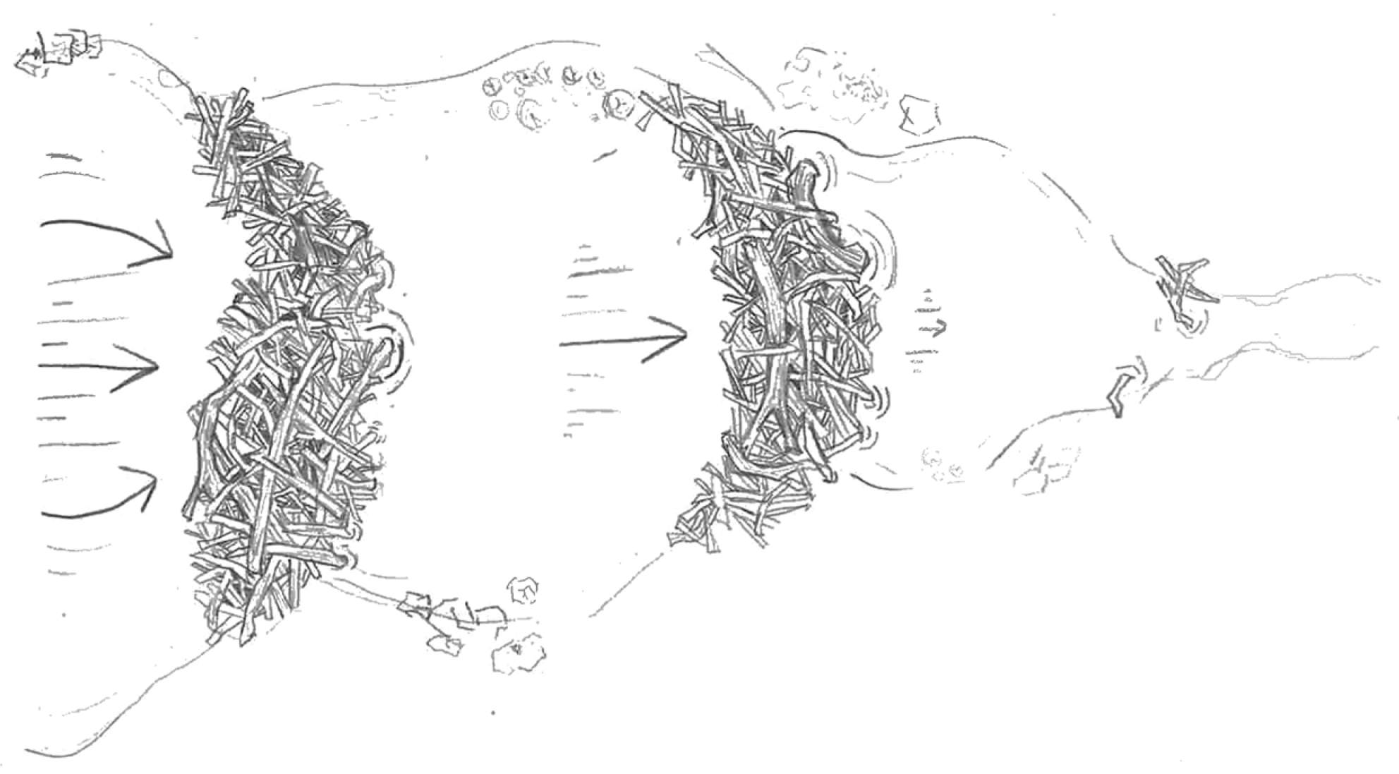
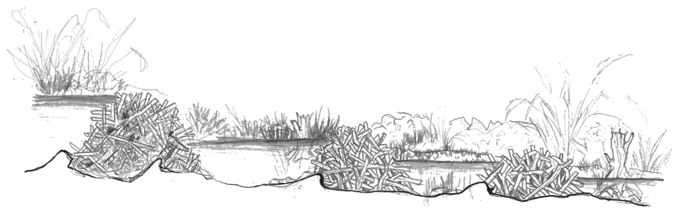
Red Eagle Creek Trail and Beaver Pond LoopRivers with several channels, trees/logs with stripped bark, evidence of burrow excavation, beaver tracks and signs, beaver bank burrows, channel bank overhangs, beaver food cache, beaver slide, beaver canal, clustered or contagious distribution of Salix sp., evidence of hyporheic flow, depressed topographic relief for snowmelt collection, deep sediment deposition, evidence of lower stream power, longitudinal ponds sequence, sequential dams, marshy meadows, undulations of drained pond floors Multi-channel rivers and sequential dams mimic can create varied water flow patterns, helping to store and slow down water movement. Canals and ponds maintain wetland areas, promote groundwater recharge, and support vegetation diversity. Willows can provide shade, reduce evaporation, and support local wildlife in marshy areas. Small topographic depressions can collect snowmelt or rainfall, storing seasonal water sources for wildlife.
Table 3. Interpretation of the normalized difference water index as applied to the landscape.
NDWI RangeSurface Condition
0.2–1Water surface
0.0–0.2Flooding, humidity
−0.3–0.0Moderate drought, non-aqueous surfaces
−1–−0.3Drought, non-aqueous surfaces
Table 4. Reported scores for VLE evaluation using the TREE-PG implementation prioritization scale (TIPS).
CategoryTotal Points PossiblePoints Scored
Core-Order Subscale187
First-Order Subscale5429
Second-Order Subscale5435
Third-Order Subscale1813
Total Score for VLE14484
Disclaimer/Publisher’s Note: The statements, opinions and data contained in all publications are solely those of the individual author(s) and contributor(s) and not of MDPI and/or the editor(s). MDPI and/or the editor(s) disclaim responsibility for any injury to people or property resulting from any ideas, methods, instructions or products referred to in the content.

