1. Introduction
The “natural world” has been transformed into almost a million fragments. Biodiversity loss is largely led by human activities, and protected areas are the cornerstone of conservation efforts, as 56% of the terrestrial surface remains classified as “low human impact” or “areas minimally impacted by people” but is heavily fragmented [
1]. The extent of wilderness areas has declined dramatically, with “95% of land having at least some degree of modification by human activity” [
2] (p. 1). This process of fragmentation continues today [
3], mainly owing to land use changes producing wild remnant patches, in some cases considered the “last pristine regions” and often the target of conservation through protection measures. The growth of the “global network” of protected areas in recent decades [
4] is evidence of this fragmentation, represented by the number, extent, and shape of sites [
5]. The restoration and connectivity of the spaces in-between protected places remain the main challenges [
6], while effectiveness continues to be measured in terms of its capacity for “resisting anthropogenic pressures” [
7].
Colonization, as a form of appropriation by transformation, is supported by powerful ideas that suppose the existence of “uninhabited land”, “empty space”, and “
terra nullius” [
8]. In some countries with low population density or apparently uninhabited territories, colonization has been promoted by national policies looking for the settlement of colons to enforce sovereignty and bring about the economic incorporation of “marginal spaces” into the nation-state project [
9]. Even today, economic growth and development in South America, like in other Global South regions, are commonly linked to ecosystem transformation and market-based conservation [
10], basically cutting down and burning forest to replace it with pastures and the growth of soybean, oil palms, or eucalyptus crops within a deforestation–agrobusiness colonization system [
11]. All this happens because, usually, places which are targets for colonization within national contexts represent opportunities for exploitation under privileged concessions to the private sector, especially where indigenous and other local peoples’ property and use rights are not legally acknowledged, thus displacing them [
12], or where private ownership and markets grant the right for landowners or concessionaries to do what they want with the land [
13].
Historically, protected areas have been established to avoid the colonization of selected natural attributes, such as emblematic or iconic places and landscapes, prohibiting, or at least limiting, the possibilities of occupation and use within sites designated as public property or as sites of national interest or world heritage [
14]. However, some protected areas also report different increasing human population densities [
15], which indicates that they are “occupied” and used by different actors, ranging from local inhabitants, whose traditional territories and livelihoods overlap with them, to, in other cases, extractive industries and even criminal organizations profiting from valuable resources at low cost, with huge environmental externalities and conflicts. Under different forms of appropriation of the “public”, where the State has no law enforcement capabilities against forbidden activities, “protected” is just a metaphor or a political fiction. But there are other ways in which colonization arrives at and appropriates the space within and around protected areas, as part of concessions (e.g., tourism and aquiculture), real estate businesses, and private conservation and rewilding projects [
16,
17]. In these scenarios, colonization implies other discussions on the alienation of public spaces and the allocation of property and use rights.
During the last decade, but in recent years especially, critical perspectives from academic research and social and indigenous movements [
18] have gained strength around the central role of conservation policies as part of a colonial and neoliberal model [
19]. These include global targets promising to “save biodiversity” and leading to objects of intervention in all those situations considered “human pressures” and “threats” [
20]. In general, the concept of a protected area itself matches with colonialism and neoliberalism because, under the flag of conservation, it appropriates spaces considered to be “with no owner” (public property or international waters) or with owners following a regime with the conviction that this is better for all. The empire of conservation expands its range through the adhesion and accumulation of new protected areas as part of a global network, following the increasing extent and coverage goals as a percentage of the planet within the framework of international community agreements [
21]. In this selective and expansive–accumulative process, the encounter with people inhabiting or using these territories, i.e., the targets of conservation, is more and more unavoidable.
Protected areas represent, in fact, the dominant globally coordinated intervention to fight against biodiversity loss [
22], which works based on designating specific sites as refugia to safeguard representative samples of genes, species, ecosystems, and ecological processes. This “global strategy” to achieve ecosystem representativeness is not enough to face a systemic crisis, as climate change has shown an oversaturation of overlapping categories and regimes [
23] distorting the aims for which they were created and involving doubtful institutional competencies, leading to inefficacy, distrust, waste of financial resources, and excessive planning with no actions. Skepticism is growing among the different stakeholders contesting the promise to save fragments of wild nature while environmental change is happening at the global scale owing to things happening mainly in the unprotected areas highly impacted by some human activities [
1] whose consequences affect the planet as a whole.
The concept of “Anthropocene refugia”, proposed by Monsarrat, Jarvie, and Svenning in 2019 [
2], “refers to areas allowing the long-term survival and persistence of organisms that are sensitive to human activities and providing sources for broader recovery if pressures are decreased” (p. 2). The role that humans play in shaping the composition of species assemblages across landscapes and seascapes is difficult to ignore; in this sense, to “Identify the space available for biodiversity protection and recovery in this human-dominated world is a challenge that requires a comprehensive understanding of the interactions between species’ natural biogeographic patterns and the spatial distribution of anthropogenic pressures” (pp. 1–2). To understand how biogeographic patterns emerge in this “human-dominated world”, the concept of Anthropocene refugia “combines the protection perspective with the restoration (reintroduction or rewilding) perspective, in contrast to more classic conservation approaches with focus in the former” (p. 2); in this way, the conceptual framework is a complementary tool “to previous efforts to identify priority regions for establishing protected areas or remaining wilderness areas, but acknowledges that species’ persistence does not only rely on the existence of formally protected or pressure-free areas” (p. 2).
In the Chilean Patagonia, those areas identified to have a higher potential of serving as climatic refugia, referring to “locations projected to harbor remnants of present-day climate, which may serve as safe havens for biodiversity under future climate change” [
2] (p. 2), coincide partially with protected areas, particularly in correlation with “primary forests” and macroalgae forests, some of them outside the protection system [
24]. The prioritization of protected areas “to establish conservation actions in specific zones, getting ahead the impacts or threats” (p. 5) seems the only option for “particularly sensible” ecosystems where “the challenges imposed by the acceleration of climate change –produced by anthropogenic action—and the impacts that it has generated on ecosystems and biodiversity, the identification of refuges for biodiversity has become increasingly important” (p. 4). “Refugia, therefore, arise as an important issue for biological conservation, since their identification and protection can guarantee the subsistence of species in current and future climate conditions” (p. 4). However, variables associated with “socio-environmental threats” have been not considered, even though this dimension is key in the planning of protected areas when “threats may coincide with areas identified as climate refuges and require particular management in pursuit of their conservation” [
24] (p. 22). In this way, the concept of climate refugia “fails to incorporate anthropogenic pressures that, along with climate change, can affect the distribution of species in an increasingly human-dominated world. The concept of Anthropocene refugia overcomes this limitation by incorporating climate change and a wide range of anthropogenic pressures into the identification of refugia” as a spatial entity [
2] (p. 2).
This article explores the current situation of human settlement within and around (in a buffer zone) the Wild Protected Area System in Southern Chile, using the amount of information available in different cartographic sources evidencing human activity and conservation efforts, interpreted as a relational flow between the protected within and unprotected outside. Human activity is used here in a general sense to refer to spatially explicit evidence of human-related features or cultural landscape modifications, rather than concepts of human beings as a source of danger, “anthropogenic pressures”, and “socio-environmental threats”. In the Results section, a composition is essayed to represent and interpret the patterns and possible processes related to contemporary human settlement colonizing protected spaces in an alternative way. In conclusion, from the perspective of this work, protected areas are the ultimate Anthropocene refugia because—within the current hegemonic conservation model—there is no refuge for biological and cultural diversity beyond “spatial entities” under a protection regime. Because not all wilderness remnants are within protected areas, it appears that there is no space for a refuge except within the conservation imperative. However, it is necessary to say that many protected areas and other wild remnants without protection measures coincide with indigenous and other local people’s territories in which people coexist with biodiversity. If we consider the Anthropocene as a framework, refugia are fundamentally a political decision where human activity is not only a threat but also a key component of the solutions both within and beyond protected areas.
3. Results
According to the population and Wild Protected Area distribution in Southern Chile, there are three differentiated regional patterns (
Figure 2,
Figure 3 and
Figure 4): region (a) encompasses La Araucanía and reaches the north of the Los Lagos region, including the Chiloe archipelago; region (b) stretches from the southern continental section of the Los Lagos and Aysén regions; and (c) is the Magallanes region. The latter two comprise what is known as Chilean Patagonia. Patterns directly related to protected areas include peri-urban areas, clusters of fragmented and perforated areas, continuously interconnected areas, and isolated–remote areas. Each pattern depends on the size, shape, and distance of human settlements, indicating different forms of the appropriation of the surrounding protected space, and each features its own stories of settlement and protection in the context of the Chilean nation-state and before. While the colonization policy in the La Araucanía and Los Lagos regions began in the middle XIX century, based on the possibility of establishing agriculture and the need to effectively occupy the land through its exploitation [
26], the history of Chilean Patagonia is strongly linked with the Mapuche people and their struggle for the land with forest companies [
27]. Chilean Patagonia has been defined through powerful metaphors (myths), including those of the “last pristine ecosystems”, “virgin regions”, “wild nature refuge”, and “the end of the world”; it is an “imagined space, in which the production of cartographies and narratives come back one and once again to reproduce the same archetypes” [
26] (p. 6).
These notions are based on the colonial concepts of “empty spaces”, “uninhabited territory”, and “no man’s land”, available to be occupied, where extensive parks and reserves fulfill the task of saving what would otherwise be destroyed by the exploitation of the natural resources contained within them—as if protected areas were detached from the rest of the world—a form of thinking very much rooted in the “mainstream” ideology of biodiversity conservation, defined by a political background of “islands” and “fortresses” to be managed. Despite the dominant image of La Patagonia as wild nature and uninhabited space, humans have been there for millennia and at present continue to reshape the landscape.
3.1. La Araucanía, Los Ríos, and Northern Los Lagos
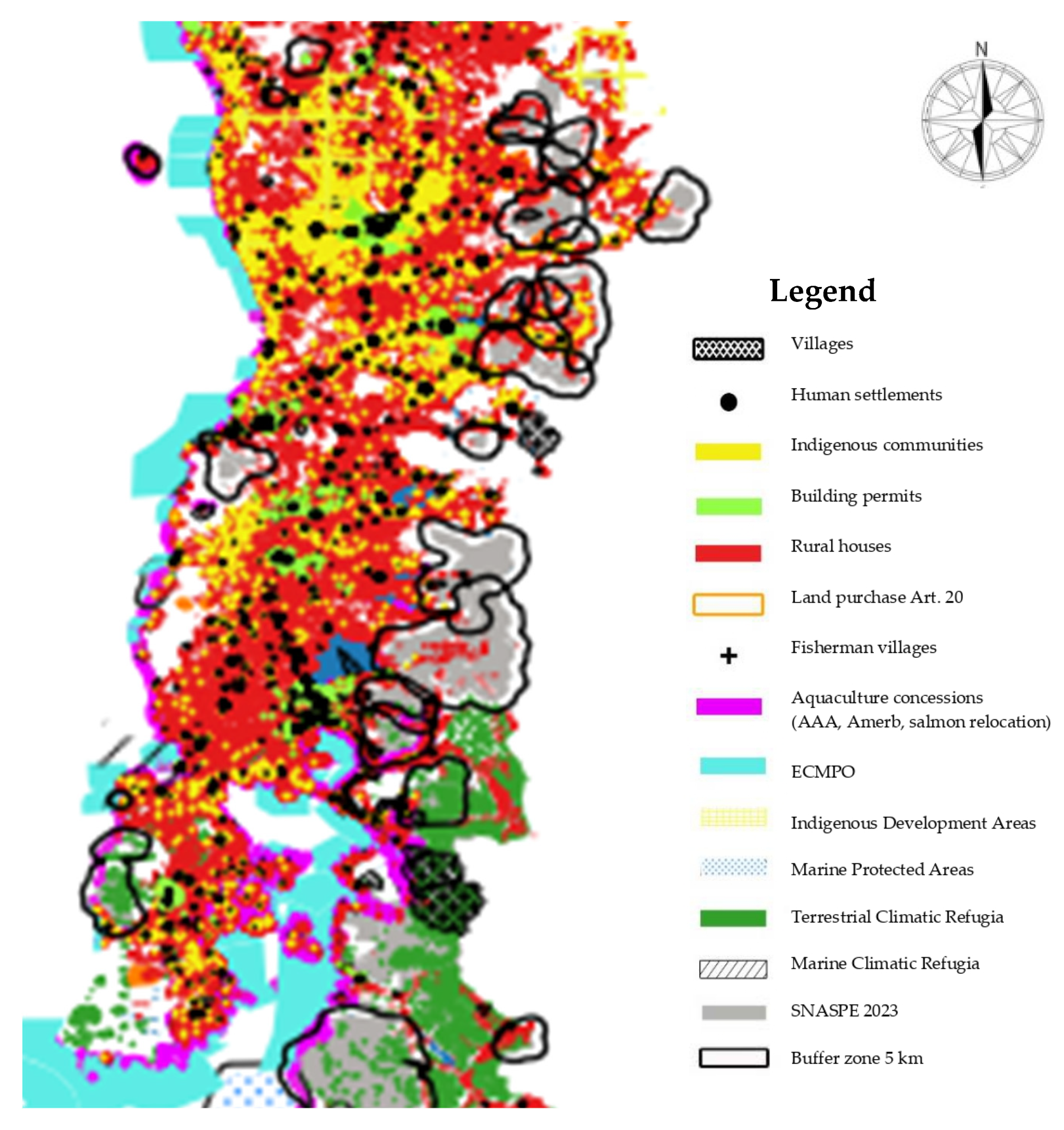
Figure 2 shows a relatively high population density with nucleated settlements, namely, cities and towns (black spots), following a linear pattern along infrastructure elements such as roads, in concordance with the general pattern of intensive land use and transformed landscapes in the central part of Chile until the Chiloe archipelago. Small protected areas around urban perimeters, such as the Cerro Ñielol and Lahuel Ñadi Natural Monuments, show a significant number of building permits (green point cloud) in the buffer zone, at 112 and 20, respectively. Indigenous communities (yellow point cloud) are especially representative in La Araucanía, showing a significative concentration around protected areas, but are more dispersed in Los Ríos and Los Lagos regions. Indigenous peoples have an important place in the conservation and protected area scenario [
27], as “subjects of rights” and historical land reclamations against the State and forest companies. Land purchased by CONADI and assigned to indigenous peoples (orange spots) evidences their recognition and territorial re-appropriation. Although there is just 1 indigenous community registered within the Wild Protected Area System in Vicente Perez Rosales National Park, there are another 136 in the buffer zone (94% of the total), especially in the Cerro Ñielol Natural Monument (43 communities), Villarrica National Reserve (30 communities), and the Chiloe and Alerce Costero National Parks (9 and 3 communities, respectively).
Figure 2.
Composition of human settlements and the Wild Protected Area System in Southern Chile. Data associated with the figure are presented in
Appendix B. La Araucanía, Los Ríos, and northern Los Lagos.
Figure 2.
Composition of human settlements and the Wild Protected Area System in Southern Chile. Data associated with the figure are presented in
Appendix B. La Araucanía, Los Ríos, and northern Los Lagos.
The dense cloud of rural houses (red area) within protected areas accounts for 222 houses in La Araucanía, 5 in Los Ríos, and 270 in Los Lagos, representing 60% of the study area. Especially significant is Vicente Pérez Rosales, with 130 houses, Villarrica National Reserve, with 105, Llanquihue National Reserve, with 50, Puyehue National Park, with 48, Conguillio National Park, with 34, and Villarrica National Park, with 24. The dispersed rural settlements occupying the spaces among the clusters of fragmented and perforated protected areas indicate possible processes of land division (loteos), alienation of public lands, and the titling of private ownership. Although Wild Protected Areas (gray spots) and a few other “white” patches outside the protection system are still the least populated spaces, there are rural houses in most of them, as evidence of settlements. Especially in the buffer zone, there are significant numbers of villages in the Alerce Costero National Park and Llanquihue National Reserve, which account for 130 and 354 houses, respectively. Probably, some of these rural houses are infrastructures associated with protected area management (guardaparques houses), but they may also be touristic concessions and, less often, “private” properties and “other ruralities”. The number of rural houses is correlated with the number of visitors. In La Araucanía, the Malalcahuello National Reserve and Conguillio National Park attracted 186,052 and 125,176 visitors, respectively, in the year 2023 (472,150 in total), while in Los Lagos, Vicente Perez Rosales National Park accounted for 519,641 and Puyehue for 106,402 (738,487 in total) in the same year. These two regions alone, taken together, represent 60% of SNASPE visitors in the country.
3.2. Southern Los Lagos (Continental) and Aysén Region
In contrast with the north of the study area,
Figure 3 shows the advance of settlement in what is called “the land in-between” (Trapananda), with a different spatial distribution pattern in the southern continental part of Los Lagos and Aysén regions, where the colonization process based on land clearing, forest exploitation and burning, pasture growth, and private conservation and rewilding projects continues until the present day.
Figure 3.
Composition of human settlements and the Wild Protected Area System in Southern Chile. Data associated with the figure are presented in
Appendix B. Southern Los Lagos and Aysén.
Figure 3.
Composition of human settlements and the Wild Protected Area System in Southern Chile. Data associated with the figure are presented in
Appendix B. Southern Los Lagos and Aysén.
Rural houses (red areas) are much more dispersed, following linear patterns along infrastructure connected with the Austral Road. Nucleated settlements and houses in villages (caseríos) play an important role as populated enclaves in the buffer zones around the Corcovado, Alerce Andino, and Pumalin National Parks, amounting to 117, 105, and 51 settlements each, respectively. Rural spaces (white patches) without visible population and protected areas (gray areas) are sprinkled with forests, climatic refugia covering a significant proportion of the Andes mountain range.
A dense cloud of rural houses and 70 building permits around the Coyahique Natural Reserve is observed near the urban perimeter of Coyahique city. The same cloud expands into the northern buffer part of Cerro Castillo National Park (with seven rural houses) and follows the park’s border in the southern direction in a linear pattern. There are also disperse settlements around the Río Simpson Natural Reserve, with 18 building permits in the buffer zone connecting Coyahique and Puerto Aysén-Puerto Chacabuco, the main point of access to archipelagic territories. This is another example of urban expansion and conurbation into more fragmented and perforated protected areas. Another linear pattern of rural houses is within the borders of Laguna San Rafael National Park (in the western part) along the Austral Road, connected with Patagonia National Park (41 rural houses). This pattern is influenced by both Cochrane town and General Carrera lake settlements, which provide different routes of access to glaciers used by tourism operators. Patagonia National Park is an example of a colonization process based on private conservation. Land between the Cochrane and Jeinimami National Reserves was purchased strategically by Tomkins, and after being donated to the State under a public compromise, it was merged into a single protected area and recategorized, enlarging the existing system of protected areas. Pumalin National Park (with 12 rural houses within its borders and 51 more in the buffer village) is a similar case, in which the enlargement, merger, and recategorization of protected areas were motivated by private initiatives, land purchases, and releases, extending the protection of the land as a form of appropriation.
A representative feature of archipelagic territories in the Aysén region is their “floating population”, involved in a colonization process led by the aquaculture industry (violet dots) and based on concessions. This process occurs within Las Guaitecas National Reserve, overlapping with the Costal Marine Spaces of Indigenous Peoples (ECMPO) (in blue), requested by indigenous communities, which also coincide with climate refugia (algae forests). A similar pattern is observed within the coastal borders of the Isla Magdalena (68 rural houses and 1 fishing village) and Melimoyu National Parks (23 village houses). Paradoxically, no indigenous communities can be seen to be registered in the consulted sources within the study area in Aysén [
8,
27].
3.3. Magallanes Region
The settlement pattern in Magallanes is more dispersed than that in the Aysén region, with a predominant linear pattern along the road’s infrastructure. Protected areas in Magallanes are mainly located on glaciers and include transboundary ice fields, steppes, archipelagos, and the Patagonian fjord and channel system. Inland protected areas are smaller and dispersed, with an insular pattern. As shown in
Figure 4, the dispersed settlement pattern in Magallanes, represented by rural houses and villages, is indicative of cattle-based colonization by the pastoral peoples currently inhabiting the Patagonian steppe—a flat landscape with no geographical boundaries. The colonization history of the area is noted for its displacement and extermination of nomad indigenous peoples and for providing concessions of big extensions of land (estancias) to private persons and livestock companies at the end of the XIX century [
26].
There are significant villages and conurbations of the rural population along the Magallanes Strait in Punta Arenas, Puerto Natales, and Porvenir in Tierra del Fuego. Beside Punta Arenas—the capital and one of the few populated centers in the region—the Magallanes National Reserve is within the urban expansion range, with eight indigenous communities, 291 houses in villages, and 140 building permits in the buffer zone. This is a typical peri-urban protected area (like a “green space”) in the city periphery, with different kinds of administrative and human-related problems, such as multiple uncontrolled access points without control, diffuse edges, and illegal activities. Torres del Paine National Park, near Puerto Natales city, is maybe the most emblematic protected area in Chile and the second most visited in Southern Chile (after Vicente Perez Rosales National Park), with 220,912 visitors in 2023, representing 52% of all visitors to protected areas in the Magallanes region, whose population in the 2017 census was 166,533 inhabitants. This park has 93 rural houses within the protected area and 10 houses in buffer zone villages. It is probable that much of the infrastructure is associated with tourism industry concessions and real estate businesses around the protected area [
28].
Figure 4.
Composition of human settlements and the Wild Protected Area System in Southern Chile. Data associated with the figure are presented in
Appendix B. Magallanes.
Figure 4.
Composition of human settlements and the Wild Protected Area System in Southern Chile. Data associated with the figure are presented in
Appendix B. Magallanes.
The Bernardo O’Higgins, Alberto de Agostini, and Kawésqar protected areas together cover a wide, continuous, interconnected, and remote archipelagic territory with no permanent settlements, except for Puerto Eden, which has 72 rural houses, one indigenous community of the Kawésqar people, one fishing village, and one building permit, located in the middle of an apparently “uninhabited” space in the northern part of the region connected with Tortel and Puerto Natales by navigation routes. Aquaculture concessions in the Kawésqar and Alberto de Agostini protected areas are evidence of floating settlements (pontons) associated with aquaculture colonization. Currently, fishing, from a subsistence level to an industrial level, remains the main human activity within these protected areas.
The distribution of fish captures and AMERB-registered locations allows us to visualize—as a proxy—a very dynamic spreader nomadic settlement pattern in this “vast and dismembered territory” [
29] (p. 348) in a given period of time. Nearly 40,000 artisanal fishermen operate in the Patagonian fjord and channel system, with a fleet of nearly 4000 registered ships; nevertheless, “remote areas of the coast in Aysén and Magallanes regions remain almost depopulated, although subject to the presence of a floating population of fisherman and workers in the salmon industry, whose number, Aysén alone would exceed 3000 persons” [
29] (p. 347).
In Magallanes, climatic refugia [
24] are dispersed patches of land, most of them outside the protection system, but they are especially significant in marine ecosystems. ECMPO and Indigenous Development Areas in the Alberto de Agostini and Cabo de Hornos National Parks mark the persistence of the Yagan indigenous people, whose contesting of the Biosphere Reserves and biocultural perspective led by the Cape Horn International Center offers a glimpse into other energy-related issues linked to the colonization front, such as oil deposits in the Drake Pass and the promises of green hydrogen and future logistic harbors as strategic projects in the colonization of Antarctica.
3.4. Analysis of Results
Human settlement distribution is directly related to access, mobility, and connectivity. Land purchases and land division (loteos) around Wild Protected Areas take advantage of improved infrastructure and security in strategic locations (see
Figure 5). Real estate business in urban peripheries is varied and can involve the appropriation of wild spaces or coexistence with remote and isolated protected areas. Not every person within or near protected areas has the same cultural or socio-economic features; hence, to refer to “human” or “anthropogenic” pressures as a tabula rasa and a threat to the wilderness ignores the different possible forms of human life in those places. In the case of big properties such as
estancias or private conservation projects in Southern Patagonia, adjoining protected areas represent an opportunity of investment for landlords or companies. Where properties are smaller, it all depends on whether property rights are clearly assigned to land titles. But in other cases, people inhabiting a plot of land are not necessarily the owners, even though they have acquired use rights.
Land size and property rights around protected areas are probably related to how near they are to infrastructure and spaces of special interest, such as populated centers. To colonization through private conservation and rewilding projects, acquiring and accumulating land around protected areas are imperative—as in the examples of Pumalin and Patagonia National Parks, in which land was purchased using Patagonia as a trademark to develop a business with a “philanthrocapitalism” signature [
16]. These practices are evidence of how rewilding (or colonization otherwise) has displaced local peoples of their land while attracting others inside or near the limits of protected areas. Who can buy a piece of land beside a national park and create their private refuge secure from the “scorched earth” around it?
Concessions, as an important device of colonization, are a landmark of neoliberalism. In a general sense, a concession is a permission granted to private companies to exploit resources through investments for a profit, and with payment to the State as a royalty. As an archetypal neoliberal state, Chile has a long story of concessions related to public infrastructure and services such as roads, hospitals, airports, and prisons, but especially in relation to the exploitation of natural resources. Forest land concessions, for example, produce a “green desert” after displacing local inhabitants and transforming native forests into plantations or the Patagonian steppe into estancias. In any case, concessions contribute to empty spaces with only seasonal or very dispersed populations.
Tourism concessions [
30,
31] and services represent an important segment of infrastructures within Wild Protected Areas and depend on the number of visitors. The relationship between human settlements and visitor numbers in protected areas could be because improved infrastructure and the affordability of tourist circuits (Red Interlagos and Ruta de los Parques) attract tourists for the vacation season, but also for temporary or permanent residence. The presence of rural houses and villages within protected areas and nearby buffer zones indicates potential real estate activities related to population shifts and changes in land ownership. In any case, most tourism-related settlements within protected areas are occupied seasonally, in which case they represent a complementary income for permanent residents and house owners who depend on livelihoods different from tourism. With the available information consulted, it is not possible to differentiate between permanent and temporary settlements. Some observations on refugia include settlements installed by tourism operators beside remote lakes and glaciers which can be reached by hiking (see
Figure 6) or helicopters from different kinds of lodgings—including luxury hotels—around the borders of (or even inside) national parks, which could gradually be transforming these areas into permanently inhabited places.
Other temporary refugia are related to fishing territories in the archipelagos, fjords, and channels. Ancient settlements, including temporary refugia and shelters on the coasts of the Patagonian fjord and channel system, have been identified by archaeological studies and show human activity related to fishing and marine hunter-gathering from 7000 years ago. Some of the archaeological sites in the Strait of Magallanes coincide with contemporary fishing shelters [
32]. There are other situations in remote, isolated protected areas: aquaculture concessions in southern archipelagos reveal a pattern of industrial expansion and colonization where the fertile southern Pacific Ocean has supported extractive industries. This process has been well documented by several researchers [
33], indicating that Wild Protected Areas are being colonized by a wide industrial cluster of aquaculture companies as a result of concessions granted by the Chilean government under the Law of Aquaculture and Fishing. The features of the entrepreneurs and the floating worker populations involved in this process have been poorly documented (see
Figure 7). Fishing villages (caletas) are present on the coastline of just a few Wild Protected Areas, especially in Los Lagos region, but fishing territories are spread across all the archipelagos. The permanence of people and depopulation due to the collapse of fisheries and the uprooting of nomadism have led to a shift in mobility to coincide with work shifts.
Aquaculture concessions—and the salmon industry in particular—are considered the main threat to marine ecosystems and biodiversity in Southern Chile. Since its arrival to the sea of Chiloe in the 1980s and the emergence of a “sacrifice zone” [
34] due to several disasters caused by the industry [
35], salmon, as an invasive species, has expanded into the southern archipelagic region in recent decades, colonizing fjords and channels—including national parks and reserves in the Aysén and Magallanes regions. A detailed analysis of aquaculture concessions within Wild Protected Areas in the Aysén and Magallanes regions identified a total of 172 AAAs, 545 concessions (493 salmon, 6 algae, and 46 mollusks), and 134 requested relocations [
36] (p. 11). In a similar way to land concessions leading to the burning down of forests to provide livestock and profits for faraway companies in the first half of the XX century, in the marine part of Patagonia, “negative externalities produced for the salmon industry are compensated -for own benefit- with big profits enjoyed far away from there” [
26] (p. 8).
4. Discussion
This research project is an attempt to discuss the role of protected areas as refugia in a time when the “human impact” on the planet Earth has given rise to the so-called Anthropocene. References to the Anthropocene are unavoidably linked to climate change, accelerated by the impact of some human activities, especially those linked with fossil capitalism, whose effects produce cascades of systemic changes at a global scale [
37]. More than a new geological epoch or “an event” [
38], the Anthropocene is a conceptual framework that can be used to estimate the magnitude of anthropogenic pressures and the degree of ecosystem transformation and to project future scenarios related to, among others, the habitability of the planet Earth for the diversity of living things (biological and cultural diversity) as we know it at present.
As the extent of environmental change is global, there is not a single place on the Earth that is immune to the effects and consequences of that change. Protected areas were established in the last century as a model that promises, among other things, to safeguard biodiversity, environmental services, and “traditional cultures” and the associated knowledge under protection measures. In the conception of the model, protected areas were to be integrated into wider landscapes and seascapes, contributing to international conservation goals in a coordinated effort among states for the future of the world’s natural heritage, represented by the number and extent of protected areas declared as a percentage of national territories [
39]. Evidence shows that this promise of protection is not guaranteed. Protected areas succeed, in the best of cases, when they mitigate some kind of pressure and threat, keeping people far away through control and surveillance, or in other, more progressive attempts, when they integrate local peoples into protected areas as part of their management under the concept of sustainable use, participation, co-management, and, more recently, governance [
40].
Nevertheless, despite all attempts to adapt to the different struggles and resolve the conflicts and critiques, protected areas have remained unchanged when it comes to their deep foundational idea, in which conservation is aimed at delimited, designated, and managed polygons. This fragmented dichotomic thought [
41] prioritizes
part over
completeness and operates within the binaries of inside–protected/outside–sacrificed, original/transformed, patches/matrix, and nature/culture, which persist today. Even when defenders of protected areas justify the integration of sites into systems and connecting them [
42] through networks, buffer zones, and corridors across different scales, landscapes, or complementary conservation strategies [
6], the model is the same at its root: the main issue in biodiversity conservation is focused on what happens
inside protected sites to resist pressures from the unprotected outside matrix. In this way, the limits of protected areas (habitat fragments, patches, islands) remain as the ontological basis in the efforts of conservation while the outside matrix—a complex mosaic including remnants of the
original habitat—continues to be fragmented by land use change, expanding urbanization, and extractive industries. Such processes, “even if they take place outside PAs, have the potential to impact ecological functioning within them” [
43] (p. 3), and vice versa.
Owing to the scale of the matter, this paper does not aim at accuracy with respect to a single protected area or particular cases but at delineating possible trends and patterns considering inside/outside feedback as a whole—even when the emphasis is made in places under protection measures. The paper presented here is understood as an essay based on the shapes and layers of information to be explored, and otherwise as a possible comprehension of conservation efforts and human activities where the limits defining what is protected are diffused and changing over time. These limits coincide with interpretations of administrative acts that configure the geometry of spatially recognizable polygons on the map as objects of management depending on the economic and political interests at a given time and define the size, shape, and category of protected areas. These changes can lead to some areas being fragmented or disappearing due to “disaffection” (disintegration), while others are expanded or created as a result of the incorporation of public lands, the merging and recategorization of pre-existing areas, and the donation of private lands. These changes also largely depend on what happens within the protected areas and their matrix. And in this way, when the limits of what is protected change, there is no refuge guaranteed.
As an expansion/contraction process, changes in geometry and categorization are part of the history of Chilean protected areas [
44]. The demographic and socio-economic features of unprotected spaces around protected areas are relevant to understanding where different colonization processes could be occurring. During the last century, protected areas were the main strategy intended to “keep people away” from places aimed at wild nature conservation. Early political and legal frameworks related to natural resource management and environmental protection contributed to discouraging or ordering advances into colonization territories, with the delimitation of protected areas as lands unavailable for settlement. The arrival of aquaculture in protected areas is a consequence of the interpretation and delineation of the term “protected” as being limited to the islands, while the channels among them were considered the unprotected outside. Recent changes in the interpretation of administrative acts and limits included the marine part of the protected archipelagos, leading to attempts by the industry to gain access to spaces contested by indigenous communities in coastal areas (ECMPO) based on floating settlements and aquaculture centers. With the exception of tourists, scientists, and administrative staff, the occupation and exploitation of natural resources are considered human pressures, threatening conservation targets within protected areas and an object of prohibition, control, and surveillance [
45]. This strategy has driven the displacement of indigenous and other local peoples around the world [
12], depriving them of their territories and livelihoods and leading to the colonization of new protected territories in the name of conservation [
18].
However, there is a reverse process in which protected areas in other rural—sometimes remote—natural spaces are attracting new pioneers eager to colonize the “last wild refugia”. Unlike the “threat” represented by the poorest peoples “invading” and “preying” on the wild frontier, where land has no owner, companies and entrepreneurs have encountered a source of valuable pristine untapped resources in protected areas and around them. The unprotected space around protected areas receives special attention in our analyses because it is considered the space for the possible expansion and connectivity of the system, including other public or private conservation initiatives [
37]. In another way, it is the space for real estate businesses in privileged locations where the fragmentation process advances into the protected edges and beyond based on the added value of wild lands. Real estate business, tourism concessions, and the aquaculture industry are examples of this form of colonization, which attracts powerful actors with the capacity to acquire property and use rights under the umbrella of neoliberalism.
Concepts such as Anthropocene refugia and climatic refugia reproduce the model of conservation based on selected places (“refugia as spatial entity”) as a target of protection and restoration and as the only way to safeguard “the space available for biodiversity in the Anthropocene”, a time of anthropogenic pressures producing accelerated changes and affecting the distribution of species in an “increasingly human-dominated world” [
2] (p. 2). Unlike the climatic refugia of the late Quaternary (past periods of glacial–interglacial oscillations), where biodiversity was concentrated during glacial periods and from where it expanded in interglacial periods as a result of a natural process, the location, extent, and shape of protected areas functioning as biodiversity refugia is a political decision. If protected places coincide, at present, for example, with climatic or Anthropocene refugia, it is because they have been chosen to be “kept intact” (untouched) or to be sustainably managed “representative” fragments of wild nature, in the form of monuments, parks, or reserves, among other categories. Climatic refugia identified in the Chilean Patagonia [
21] show that protected areas and climatic refugia coincide partially, but significant places remain outside the protection system; “their identification and protection can guarantee the subsistence of species in current and future climate conditions” (p. 4).
“The terms ‘refuge’ or ‘refugia’ are commonly used to refer to areas where components of biodiversity retreat to, and persist in, under increasing environmental stress, with the potential to re-expand once the stress decreases. […] Such areas can act as sources of recolonization when environmental conditions improve” [
2] (p. 2). Historically, protected areas have served as refugia for wild nature and as safe places to protect it from destruction [
14]. In this “space available for biodiversity in a human-dominated world” [
2], the anthropocentric idea—part of the dichotomic Cartesian tradition—that humans dominate the world and that the world is an object of domination is at the root of Western colonial thinking. We can identify the subjects of refuge, decide on their protection or restoration, and assess their re-expansion (liberation) as if nature’s behavior depended on human vision. The ideas of world-dominated humans or of nature that is out of control are politically uncomfortable.
Could biological and cultural diversity be “stocked” in protected areas to resist the systemic changes caused by the Anthropocene? We can imagine any contemporary refugee camp with a deprivation (scarcity) of basic things for subsistence, such as freshwater, food, medicines, shelter, and so on; refugees are confined to “safe” places, “protected” by international law, and a protector host that takes care of assigning them this site as secure. There is no protection outside the limits of the camp; even inside it, the refugees can be the targets of destruction. Is this conservation? [
46] Species can survive by themselves, because their inhabited environment supplies them with all that they need in reciprocal feedback. When this environment changes negatively or is destroyed, they must move to another place with the safest conditions to continue living. This newfound relatively safe place to survive is a refuge that limits the possibilities of persisting for the refugees located within the protected site, while, paradoxically, what remains outside (unprotected) is the object of exploitation and sacrifice. How long will the limits of the refuge be secure?
5. Conclusions
Anthropocene refugia, considered a political decision, are a powerful concept that rethinks the place of protected areas and the unprotected spaces around them as part of a model of exploitation and consumption where conservation is part of capital accumulation. In a changing world where the “anthropogenic pressures” are on a global scale, its capacity to meet the needs of a diversity of species that are constrained to sites with favorable conditions does not depend just on climate change but on deep transformations in the behavior of human societies, ideological bases, lifestyles, and consumption patterns, among others. The model of the creation, planning, and management of protected areas is fundamentally linked to the possibility of delimiting a polygon that can be fenced and monitored, in which what is within the limits can be protected, as opposed to an unprotected outside where there are other rules. If the protection status remains limited just to some places, there will be no refugia for all. Is there environmental justice in the Anthropocene?
In Chile, these limits are diffuse and change with time. However, transformations in the institutional design are occurring as part of the creation of a National Biodiversity and Protected Areas Service (SBAP) in 2023—after 10 years of discussions—which expands the spectrum of conservation to “all ecosystems, both on land and in the sea, in public and private and not only inside but also outside protected areas”. The south of Chile, and Patagonia in particular, offers an important observation scenario through which to understand the challenges faced due to the kind of pressures exerted by large business interests and to assess the exploitation of resources granted by the State in a neoliberal context.
In most cases, protected areas are islands (patches) surrounded by human-occupied land, but on rare occasions, we also find human settlements surrounded by protected areas (e.g., Puerto Gaviota and Puerto Edén). It is clear that island-type protected areas like those that exist on the mainland do not work well in the Patagonian archipelagos. The couplings of protected and unprotected spaces depend on the relationships of the human populations with the places they inhabit and the type of socio-ecosystems they produce. In other words, if the conservation targets of protected areas are, for example, forest ecosystems, it is likely that there are also forests beyond their boundaries, in the unprotected spaces, where the land has other owners and also other uses. The viability of these forests to remain as refugia depends largely on their extent and connectivity (structure and composition), and they will only persist if they are not burned or cut down and replaced by other things. Human settlements and their populations located between protected areas, on their edges, or within them offer a rich co-elaboration scenario in which to explore other possible forms of relationship between people and the inhabited environment where the idea of protection and conservation can take other meanings.
My essay shows that protected areas are not floating in a space free of human interests and political decisions. Because of the scale of visualization used here, this paper shows an exaggeration of the represented features, just as a trend indicative of spatial distribution patterns. The relevance of this research project is the possibility of approximating where protected areas and human-related assemblages have a higher probability of resulting in colonization processes, without calling them human pressures necessarily. Represented on another scale, the distribution of human settlements and protected areas reveals white spaces coinciding partially with climatic refugia but also with spaces “available” for biodiversity outside of protected areas, with different land uses and property mosaics.
This article provides a general overview of human settlements within and around the Wild Protected Area System in Southern Chile based on the amount of available spatially explicit information and other bibliographical sources. However, in conclusion, a more detailed scale of analysis of human settlements, including data on population demographics, land and sea use, and land tenure in a time-lapse and including their counterparts in Argentina, is necessary to better understand the population dynamics and the kind of changes that happen where the transformation of ecosystems continues. Is the growing population colonizing wild spaces or decreasing as a consequence of depopulation and land abandonment? What changes will there be in protected areas under different demographic, socio-economic, and political scenarios in the future? Maybe, some answers to these questions could be possible as a result of an innovative interdisciplinary research agenda, including a more effective interaction among science, policy, and institutional design. A system of protection measures based on reliable knowledge rather than neoliberal business practices would allow for improved accuracy and effectiveness in decision-making on the human-related processes within and around Wild Protected Areas considering the needs of refugia for all living beings in the Anthropocene.


