Article

Living Cultural Infrastructure as a Model for Biocultural Conservation: A Case Study of the Maekha Canal, Chiang Mai, Thailand

by
Warong Wonglangka
1,*,
Samart Suwannarat
2 and
Sudarat Auttarat
2,*
1
Faculty of Architecture, Chiang Mai University, 239 Huay Kaew Road, Suthep, Muang, Chiang Mai 50200, Thailand
2
Multidisciplinary Research Institute (MDRI), Chiang Mai University, 239 Huay Kaew Road, Suthep, Muang, Chiang Mai 50200, Thailand
*
Authors to whom correspondence should be addressed.
Conservation 2025, 5(3), 45; https://doi.org/10.3390/conservation5030045
Submission received: 4 August 2025 / Revised: 25 August 2025 / Accepted: 26 August 2025 / Published: 29 August 2025

Abstract

This paper introduces and defines ‘Living Cultural Infrastructure’ as dynamic social-ecological systems where plant heritage and community knowledge are co-produced to reclaim degraded urban landscapes. Addressing the dual challenges of ecological degradation and cultural erosion, we demonstrate this concept through a case study on the Maekha Canal in Chiang Mai, Thailand, employing Participatory Landscape Architecture integrated with urban ethnobotany. Through co-design workshops, biocultural spatial analysis, and ethnobotanical surveys involving 20 key community members, the project engaged residents to reclaim the canal as a functional biocultural corridor. The research documented 149 culturally significant plant species and resulted in a co-created trail system that embodies the principles of a living infrastructure, fostering intergenerational knowledge exchange and strengthening community stewardship. This study demonstrates how a participatory, ethnobotany-informed process can regenerate degraded urban waterways into Living Cultural Infrastructure. The research advances a new paradigm for landscape architecture by providing replicable governance and design tools.

1. Introduction

1.1. Background of the Study

Amid accelerating urbanization, many cities in Southeast Asia have witnessed the fragmentation of green spaces, ecological degradation, and the erosion of cultural landscapes [1]. The development of urban green infrastructure (UGI), particularly linear green corridors, offers a nature-based response to these pressures. However, scholarly focus has largely emphasized large-scale systems, leaving the ecological and social roles of small-scale corridors within dense city centers underexamined [2]. Integrating cultural heritage into these corridors can create synergistic outcomes, fostering both biodiversity and civic pride, as seen in projects such as the Hangzhou Grand Canal [3]. This paper advances this approach by introducing the concept of ‘Living Cultural Infrastructure’: dynamic social-ecological systems where plant heritage, community knowledge, and spatial design are co-produced to foster both ecological resilience and cultural identity, serving as a novel model for urban biocultural conservation.
A novel lens for understanding these systems is urban ethnobotany, which foregrounds how traditional plant knowledge is maintained, adapted, and redefined within cityscapes [4]. Urban dwellers often transform small gardens, markets, or canals into biocultural refugia where they continue to engage with plants for medicinal, culinary, and ritual purposes [5]. While studies in Europe and the Americas have demonstrated the role of urban gardens in sustaining both biodiversity and cultural identity [6,7,8], a significant knowledge gap remains, particularly in Southeast Asian cities, where this informal knowledge is often overlooked. This gap is critical, as recent scholarship argues for applying biocultural stewardship models, traditionally studied in rural contexts, to multicultural urban settings as a pathway to sustainability and well-being [9].
This study addresses these interconnected research gaps by proposing a model for the co-production of space wherein communities and designers act as equal partners to create unique, context-responsive landscapes [10]. We document this process through the development of an urban ethnobotanical trail along the Maekha Canal in Chiang Mai, Thailand. The project investigates how this overlooked urban corridor can become a platform for integrating ecological restoration, local plant knowledge, and cultural memory. By applying both UGI and ethnobotanical perspectives, the study repositions human–plant relationships as central to sustainable urban futures.
However, such participatory revitalization projects are not without risks. Interventions in urban green space can inadvertently lead to “green gentrification,” where environmental improvements increase property values and displace long-term, often marginalized, residents. Furthermore, participatory processes themselves can face challenges of elite capture or scalability limitations. This study interrogates these complexities by foregrounding a process that builds community agency and stewardship from the ground up, offering insights into mitigating potential risks such as green gentrification and elite capture.
Ultimately, the Maekha Canal case offers conceptual and methodological insights that may be transferable to other small-scale urban waterways across Southeast Asia, contributing not only to localized place-making strategies but also to broader regional discourses on biocultural regeneration in rapidly urbanizing contexts.

1.2. Site Profile: Maekha Canal and Its Role in Chiang Mai’s Socio-Cultural and Ecological Landscape

The Maekha Canal is one of Chiang Mai’s oldest urban water systems, historically integral to both the city’s hydrology and cultural fabric. Excavated around 1296 during the founding of the Lanna Kingdom, it functioned as part of a broader defensive and irrigation network in conjunction with the Ping River (Figure 1). Designed to manage seasonal flooding and distribute water to agricultural areas, the canal channeled runoff from Doi Suthep through its 31 km course, linking upland forests with urban and peri-urban zones. [11]. In addition to its hydrological role, the canal historically served as a socio-economic artery. It supported small-scale fisheries, waterborne transportation, and agriculture along its banks, while also hosting community rituals and cultural practices associated with water. As such, the Maekha Canal formed a vital interface between ecology and everyday life, shaping neighborhood identities and enabling intergenerational livelihoods.
However, by the late twentieth century, Chiang Mai’s rapid urban expansion and inadequate wastewater infrastructure led to the canal’s severe environmental decline. It became heavily polluted with domestic sewage, market runoff, and greywater discharge, resulting in biodiversity loss, diminished water quality, and reduced groundwater recharge [11]. In recent years, local stakeholders have initiated community-led revitalization efforts. The Maekha initiative project, spearheaded by civic groups and supported by Chiang Mai Municipality, introduced canal cleanups, constructed wetlands, bioremediation, and landscape redesigns. These efforts aim to reposition the canal as a multifunctional urban green corridor that integrates ecological restoration with cultural renewal and public space.

1.3. Current Challenges: Pollution, Habitat Degradation, and Loss of Traditional Knowledge

Despite revitalization attempts, the Maekha Canal remains a highly degraded waterway facing significant environmental and cultural challenges. Recent ecological assessments confirm its compromised health, revealing elevated biochemical oxygen demand (BOD) and persistently low dissolved oxygen (DO) levels, both indicators of poor water quality [12,13]. This pollution is exacerbated by habitat degradation, as informal settlements along the corridor discharge untreated waste directly into the watercourse, narrowing its flow and resulting in the decline of native aquatic species [14,15].
Simultaneously, this environmental degradation has precipitated a cultural decline. Traditional ecological knowledge and practices once tied to the waterway, including rituals, medicinal plant use, and agricultural techniques, have eroded due to the canal’s deterioration and reduced accessibility. This loss undermines cultural continuity and weakens the intergenerational transmission of place-based knowledge [11,14]. Although community efforts have yielded localized improvements, systemic challenges persist, as pollution remains widespread and traditional community engagement with the canal is fragmented and inconsistent [13].

1.4. Conceptual Framework

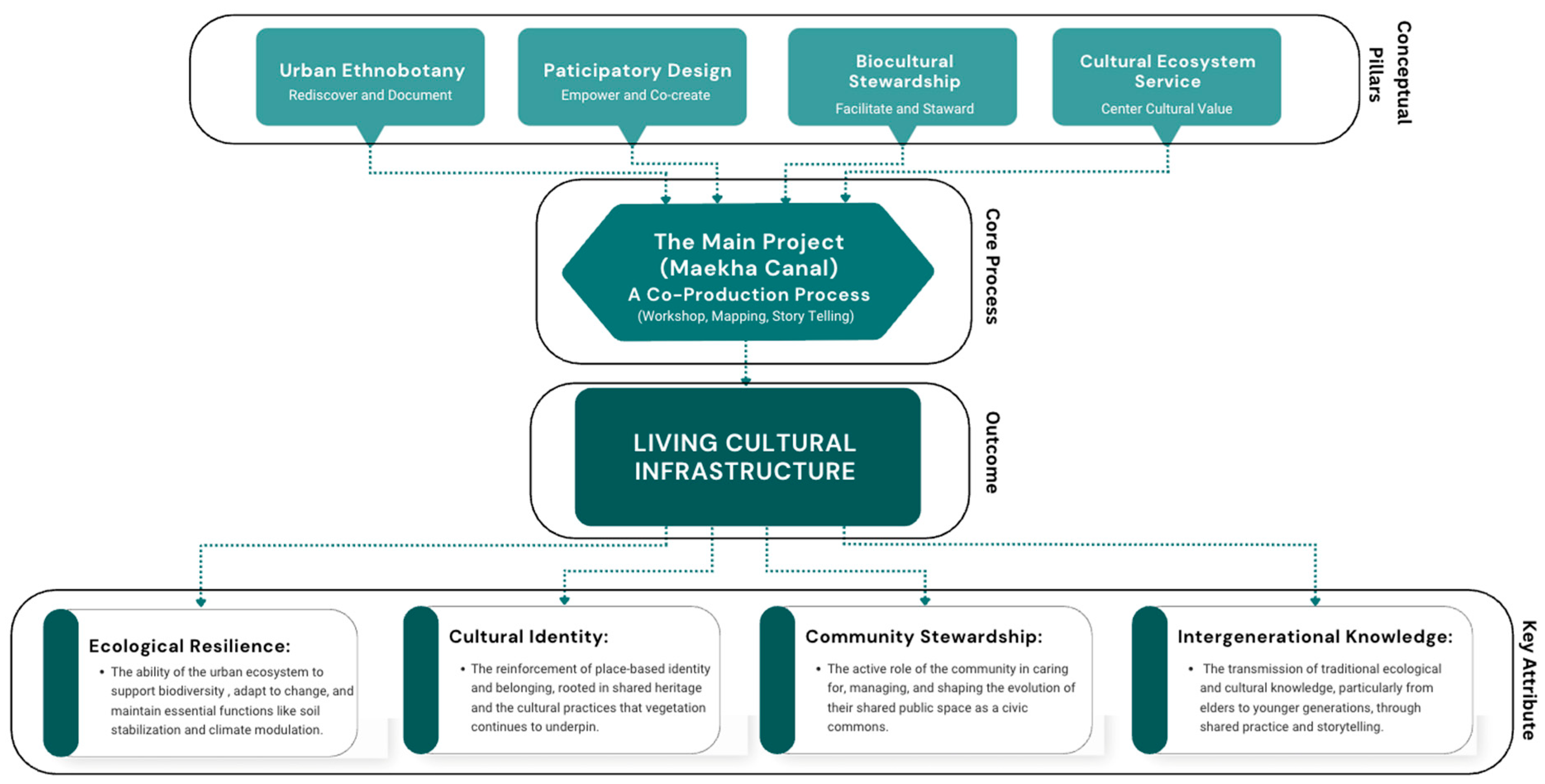
To address the socio-ecological complexities of the Maekha Canal, this study develops a conceptual framework built upon the concept of ‘Living Cultural Infrastructure’ (LCI). Unlike conventional Urban Green Infrastructure (UGI) or Nature-Based Solution (NBS) frameworks, which often prioritize ecological and technical functions, LCI positions the socio-cultural dimension as its central organizing principle. While UGI may produce cultural benefits, LCI treats community knowledge, cultural practices, and heritage not as secondary ‘services’ but as the foundational elements from which ecological and social resilience are co-produced. The ‘living’ aspect of the infrastructure refers to its capacity to be actively managed by the community (biocultural stewardship) and its ability to evolve over time, embedding memory and enabling ongoing cultural expression. To operationalize this concept, the framework integrates four distinct yet complementary approaches (Figure 2). This integrative model demonstrates a process-based methodology designed to guide the co-production of ‘Living Cultural Infrastructure’. The framework is built upon the following four pillars:
Urban Ethnobotany: This field investigates the mechanisms by which urban inhabitants sustain and adapt plant-based traditions—medicinal, culinary, and ritual—within contemporary cityscapes. For this project, methods such as participatory documentation are employed not only to preserve local knowledge but also to reinforce civic stewardship.
  • Participatory Design: Grounded in co-creation principles, to ensures that urban green spaces are culturally resonant and ecologically appropriate by directly involving stakeholders. A core tenet of this approach is civic ecology, where communities actively manage their landscapes.
  • Biocultural Stewardship: This approach centers on the active role of the community in the care, maintenance, and interpretation of their intertwined biological and cultural heritage. It emphasizes local agency in preserving place-based knowledge and practices, ensuring that the landscape’s living heritage is managed sustainably by and for the community.
  • Cultural Ecosystem Services (CESs): Finally, the framework incorporates CESs to account for the critical intangible benefits, such as recreation, spiritual value, and sense of place, that are often neglected in conventional urban planning.
As illustrated in the framework, these four pillars are synthesized through the core co-production process of the Maekha project. This iterative process, involving community workshops, mapping, and storytelling, translates abstract principles into the tangible outcome of a ‘Living Cultural Infrastructure’ a landscape typology characterized by its ecological resilience, strong cultural identity, active community stewardship, and capacity for intergenerational knowledge transmission

1.5. Research Objectives

  • To investigate and document traditional and evolving plant-based knowledge and practices among communities along the Maekha Canal, with a focus on cultural, medicinal, and ecological uses.
  • To engage local residents in a participatory co-design process to create an interpretive urban ethnobotanical trail that reflects community values, plant heritage, and site-specific ecological narratives.
  • To develop a model for community-led biocultural stewardship that integrates cultural ecosystem services, supports biodiversity conservation, and strengthens the cultural identity of the canal corridor.

2. Materials and Methods

2.1. Study Area

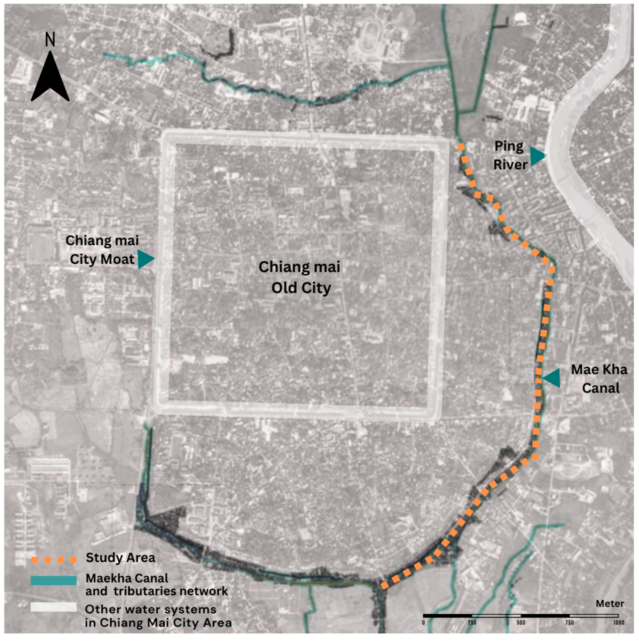
This study was conducted along a 3.5 km section of the Maekha Canal, a historically significant urban waterway that traverses the central districts of Chiang Mai, Thailand (Figure 3). The corridor encompasses diverse residential zones, including the Hua Fai and Kampaeng Ngam communities, which are characterized by a mix of long-established residents, informal settlements, and pockets of residual green space. Once integral to the city’s hydrological and cultural infrastructure, the canal now functions as a degraded urban water body undergoing grassroots-led revitalization. The study area was selected for its ecological potential, social diversity, and ongoing community engagement in place-making initiatives.

2.2. Ethnobotanical Survey and Data Collection

A qualitative ethnobotanical survey was conducted to document local plant knowledge.
  • Informant Selection: A purposive and snowball sampling strategy was employed to recruit 20 key informants (12 female, 8 male) aged between 45 and 82. Initial contact was made through a community leader, who then recommended other knowledgeable individuals. Selection criteria included a minimum of 20 years of residency in the canal-side communities and recognition by peers as having deep knowledge of local flora. This group comprised local elders, traditional healers, and community gardeners.
  • Field Methods and Data Collection: The survey employed a combination of semi-structured interviews and free-roaming transect walks along the 3.5km study area. This approach aimed for an exhaustive inventory of culturally significant plants identified by informants, rather than systematic plot surveys. Interviews were conducted in the local Northern Thai dialect, averaged 45-60 min, and took place at locations chosen by the informants. The open-ended interview protocol focused on plant names, uses (medicinal, culinary, ritual), parts utilized, preparation methods, and associated oral histories. Theoretical saturation was considered to have been reached when interviews with new informants ceased to yield new plant species or significant use categories. All interviews were audio-recorded with permission.
  • Botanical Identification: Plant species identified during interviews were documented photographically. For species requiring further identification, voucher specimens were collected, assigned a collection number, and identified using regional botanical keys. The identification was subsequently verified by specialists at Chiang Mai University, where specimens are deposited.

2.3. Participatory Co-Design Process

Following the ethnobotanical survey, a series of interactive co-design sessions were conducted to translate the collected knowledge into the trail’s design.
  • Participant Recruitment: An open invitation was extended to the broader community through local networks and public posters to mitigate self-selection bias. This resulted in the participation of a diverse group, including local artisans, youth group members, informal vendors, and other interested residents.
  • Workshop Structure: Three primary co-design workshops were held, each lasting approximately three hours. The workshops utilized visual tools such as large-scale maps, photographs of the documented plants, and drawing materials. Facilitated discussions focused on co-developing the trail’s narrative themes, prioritizing locations for interpretive “learning points,” and brainstorming features for the trail. To manage conflicting expectations, a consensus-building approach was used, where facilitators helped the group find common ground and prioritize ideas that served the broadest community benefit.

2.4. Data Analysis

  • Qualitative Analysis: Interview recordings were transcribed and translated. The transcripts were then analyzed using a thematic coding approach in NVivo software. An initial open coding process was conducted by two researchers independently to identify emergent themes. The inter-coder reliability was checked through discussion to resolve discrepancies before the codes were finalized and grouped into the 13 ethnobotanical use categories presented in the results.
  • Quantitative and Geospatial Analysis: The plant inventory data was summarized to determine the dominant families and growth forms. The ethnobotanical use data was structured to generate the chord diagram (Figure 4), visualizing the relationships between plant families and use categories. Georeferenced photographs and field notes were used to map the spatial distribution of key plant species and cultural sites along the canal corridor.

2.5. Ethical Considerations and Informed Consent

All research procedures were conducted in accordance with local legislation, including Thailand’s Personal Data Protection Act B.E. 2562 (2019). Verbal informed consent was obtained from all participants. Verbal consent was chosen over written consent to build trust and maintain an informal rapport, a practice deemed more culturally appropriate when engaging with local knowledge holders. Participants were assured of their anonymity and the confidentiality of the data provided. In line with principles of equitable benefit-sharing, all knowledge and data co-produced during this research were directly returned to the community in the form of the co-designed trail, interpretive materials and the establishment of the community storyteller program, ensuring the primary benefits remain with the knowledge holders.

3. Results

3.1. Plant Inventory

The ethnobotanical survey documented a total of 149 plant species from 71 families along the 3.5 km section of the Maekha Canal. As detailed in Table 1, the structural composition of this vegetation is categorized into six distinct growth forms, revealing a vertically stratified landscape. Woody species are dominant, with trees being the most numerous group (61 species), followed closely by shrubs (56 species). This primary structure is supplemented by climbers (15 species), ground cover plants (12 species), aquatic plants (4 species), and a single epiphytic species. This structural diversity provides critical habitat heterogeneity essential for supporting both urban biodiversity and ethnobotanical continuity.
The dominant plant families further illustrate this richness. Moraceae is the most represented family, with 13 species, followed by Araceae and Fabaceae (7 species each), Apocynaceae and Acanthaceae (6 species each), and Euphorbiaceae and Zingiberaceae (5 species each). These families collectively illustrate both ecological adaptability and cultural functionality within the urban context. The various legume families (including Fabaceae–Caesalpinioideae, Fabaceae, and others) are particularly significant, together accounting for 18 species that contribute to soil fertility. The spatial distribution and diversity of species suggest fragmented yet resilient plant communities capable of supporting habitat restoration and cultural landscape revitalization. This inventory not only reveals botanical richness but also encodes localized narratives of survival and adaptation, making it a foundational element for culturally resonant landscape design.

3.2. Usage Patterns

The ethnobotanical assessment revealed a highly diverse and functionally layered plant landscape along the Maekha Canal, with 149 species distributed across 13 major use categories. The complex relationships between these use categories and the plant families are visualized in the chord diagram (Figure 4). This visualization illustrates how vegetation underpins cultural identity and urban resilience, highlighting that certain families, such as Fabaceae and Moraceae, are highly multifunctional and contribute to numerous uses. Medicinal use emerged as the most dominant category, associated with 93 species (55%). As shown in Figure 4, this category draws from the widest array of plant families, underscoring the breadth of traditional healing knowledge. This practical, living knowledge was emphasized by one of the key informants:
“For small, everyday injuries, or when the children are playing and get a little scrape, you don’t need to go to the medicine cabinet. [Pointing to the Bitter bush, (Chromolaena odorata)] Just crush this up to stop the bleeding. The old people taught us that the plants along the canal are our medicine cabinet. We have to keep this knowledge alive for our children and grandchildren.”
—Female community elder, 68
This highlights the canal’s potential to serve as a repository for community-based health practices
Key examples consistently cited for treating common ailments include Green Chiretta (Andrographis paniculata, Acanthaceae), Siamese Cassia (Senna siamea, Fabaceae-Caesalpinioideae), and Indian Borage (Plectranthus amboinicus, Lamiaceae). Aesthetic functions, comprising flowering (71 species) and ornamental foliage (47 species) plants, were also highly prevalent. The diagram shows a strong connection between these uses and families known for their ornamental value. Plants such as Plumeria (Plumeria spp., Apocynaceae), Ixora (Ixora spp., Fabaceae), and Bougainvillea (Bougainvillea spp., Pandanaceae) are prominently planted in residential spaces. Foliage species such as Dracaena (Dracaena spp., Cannaceae) and Dumb Cane (Dieffenbachia picta, Bombacaceae) are used to soften the built landscape.
The culinary domain was also strongly represented, with 39 species used as vegetables and 33 as fruits. Figure 4 indicates that families such as Fabaceae, Lamiaceae, and Zingiberaceae are key contributors to this category. Important species include White Leadtree (Leucaena glauca, Mimosaceae), Holy Basil (Ocimum sanctum, Labiatae), and Galangal (Alpinia galanga, Zingiberaceae). The presence of species with dual roles, such as Long Pepper (Piper retrofractum, Piperaceae) and Pandan (Pandanus amaryllifolius, Pandanaceae), emphasizes the multifunctionality of the local flora. Applied uses, such as timber/wood (28 species) and natural dyes (9 species), form an essential layer of resource-based knowledge. The diagram highlights the importance of families such as Moraceae and Fabaceae for these material uses. This includes culturally significant species such as Teak (Tectona grandis, Verbenaceae) and Red Sandalwood Tree (Adenanthera pavonina, Fabaceae). Species used for dyes include Jackfruit (Artocarpus heterophyllus, Moraceae) and Butterfly Pea (Clitoria ternatea, Papilionideae), while fibers are sourced from Paper Mulberry (Broussonetia papyrifera, Moraceae) and Kapok Tree (Ceiba pentandra, Malvaceae). Cultural and ritual use categories emphasize the spiritual role of plants. Sacred species include the Bodhi tree (Ficus religiosa, Moraceae) and turmeric (Curcuma longa, Zingiberaceae), while Areca Palm (Areca catechu, Arecaceae) and Peacock Flower (Caesalpinia pulcherrima, Fabaceae-Caesalpinioideae) are used in offerings. This robust and nuanced system of plant–human relationships provides a vital foundation for curating culturally resonant and socially inclusive green space interventions.
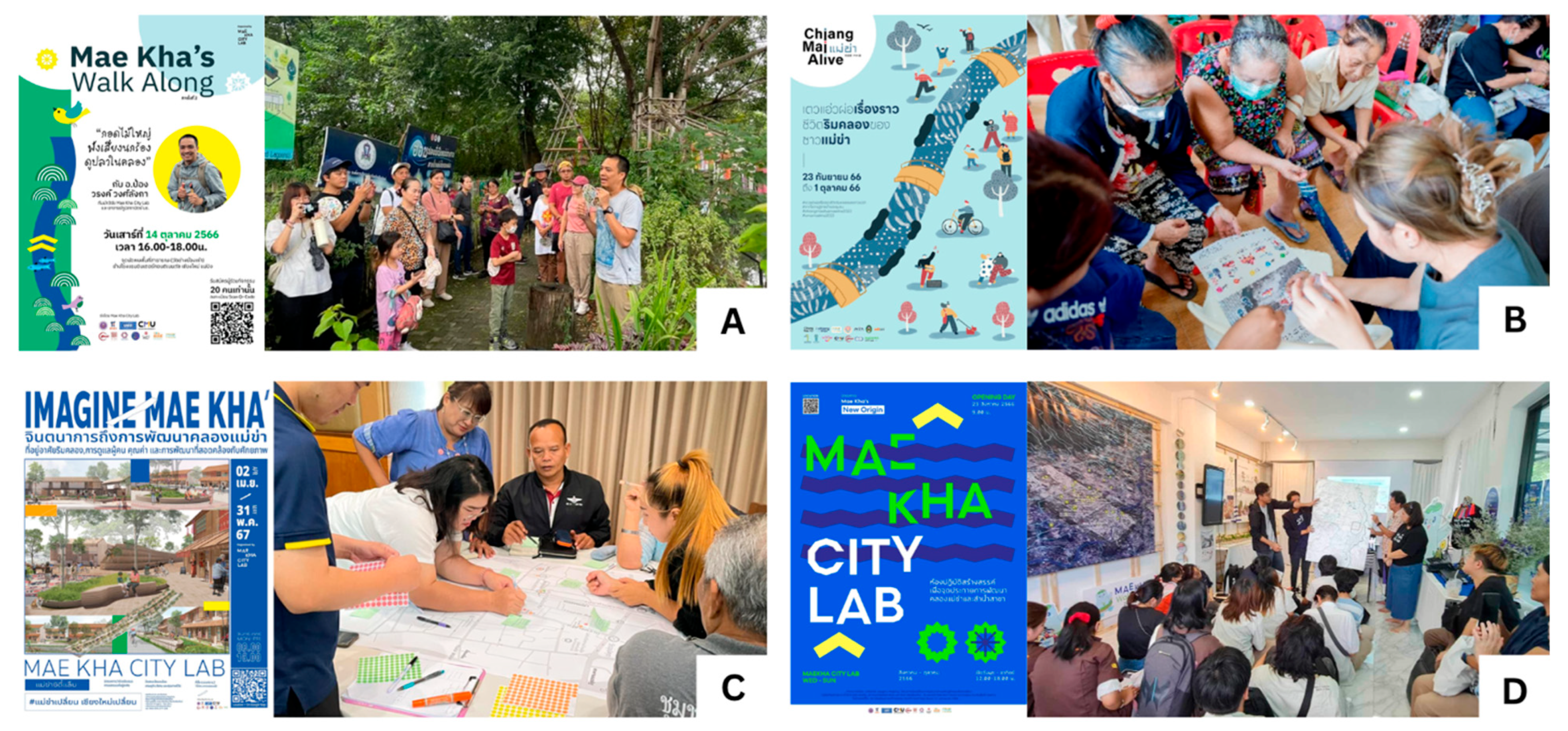
Community engagement along the Maekha Canal revealed a multilayered and dynamic interface between local ecological knowledge, cultural memory, and spatial identity. Drawing upon a suite of qualitative methods, including public forums, a series of “Mae Kha Walk Along” events, and targeted co-design workshops (Figure 5), insights were gathered from a diverse range of residents. A summary of these key engagement activities, including their objectives and participant groups, is provided in Table 2. These engagements served not only as data collection mechanisms but also as community-led acts of reclaiming and reimagining the cultural landscape of the canal.
A key insight emerged from the role of elders as custodians of biocultural knowledge. This intergenerational dimension was highlighted through the “Mae Kha Walk Along” series, where six themed walks engaged the public in topics ranging from canal history to local ecology. These events culminated in a workshop to create “community storytellers,” where elderly residents and children co-developed narratives about the canal’s flora. This process directly validated storytelling as a powerful method of informal heritage transmission. Yet, a recurring concern voiced was the erosion of this knowledge among younger generations.
Additionally, the three primary co-design workshops empowered residents to translate their needs into tangible design outcomes. For example, during a mapping exercise in one workshop, residents collectively identified a neglected area near a sacred Bodhi tree as a potential “ritual grove.” This community-led proposal directly informed the trail’s design, leading to the selection of other culturally significant plants for this zone and the inclusion of a designated space for offerings. This sense of renewed agency was a recurring theme:
“For the past thirty years, our houses turned their backs to the canal. It was just a backyard, overgrown and a place nobody wanted to look at. Since these workshops started, we have begun to turn back around. Now, we are designing its future. The same old canal is making us happier than before; it’s a place we can be proud of.”
—Male community leader, 55
A particularly innovative component was the “Mae Kha City Lab”, a participatory learning hub that served as a central point for dialogue and design experimentation. The Lab housed interactive exhibits with rotating themes. Importantly, community insights also revealed tensions. While public forums with long-term residents highlighted desires for long-term land lease rights and the preservation of their livelihoods, engagements with newer residents and business owners often prioritized concerns such as flood mitigation, sanitation, and safety. This multiplicity of visions necessitated a design framework flexible enough to accommodate divergent expectations, embedding both historical continuity and contemporary needs within the trail’s narrative and physical structure. In sum, the participatory processes demonstrated that an urban ethnobotanical trail cannot merely function as a linear display of plants, but must instead serve as a living cultural infrastructure. It should foster intergenerational dialogue, support ecological literacy, and encourage community stewardship, making the canal not just a site of memory but a platform for collective future-making.

3.3. Trail Design Output

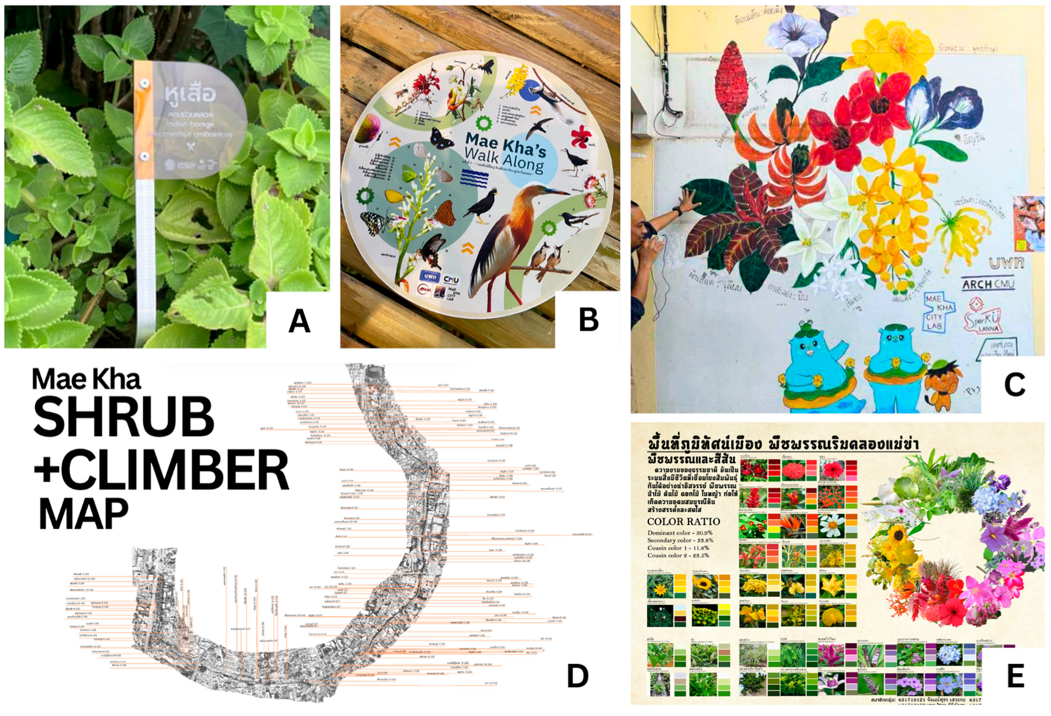
The design of the Maekha Ethnobotanical Trail, emerging directly from the participatory insights gathered in the previous section, culminated in a spatially and narratively coherent system that integrates ecological, cultural, and educational functions. Rather than a static installation, the trail was conceived as a living infrastructure, its design features directly responding to the community-identified values, biocultural knowledge, and spatial rhythms of everyday life along the canal. At the core of the trail is a unique interpretive approach built around “learning points” and dynamic human interaction. The design prioritizes storytelling and shared experience over passive observation. Key features embedded along the trail demonstrate this philosophy, as illustrated in Figure 6:
  • Living Interpretation and Interpretive Media: The most significant design feature is the establishment of a “community storyteller” program, where trained local guides share firsthand knowledge. To support this, illustrative guides for the “Walk Along” eco-tours were developed, providing visual information on local flora and fauna (Figure 6B).
  • On-Site Learning Points: The trail incorporates designated stops that use diverse media to convey information. These include clear botanical signage for identifying local plant species (Figure 6A) and vibrant, co-designed community art murals that serve as large-scale visualizations of the area’s significant flora (Figure 6C).
  • Data-Driven Educational Tools: The on-site experience is underpinned by extensive data collection, which has been translated into accessible educational materials. These range from detailed ethnobotanical maps showing the spatial distribution of plant types (Figure 6D) to analyses of the canal’s floral biodiversity, which can be used in schools and community workshops (Figure 6E).
From a landscape architectural perspective, the trail functions as more than a linear infrastructure; it is an interface for knowledge exchange, a sensorial archive, and a platform for civic imagination. By embedding community narratives within the larger web of ecological and cultural meanings, the trail design transforms an ordinary canal path into a multidimensional public landscape that is rooted in memory yet oriented toward sustainability and inclusivity.

4. Discussion

4.1. Reclaiming Urban Biocultural Space

In the context of rapidly urbanizing cities where ecological degradation and cultural homogenization are occurring in parallel, urban ethnobotany presents itself as a compelling framework for reclaiming biocultural space. Along the Maekha Canal, a corridor historically marginalized both physically and symbolically, this project repositions plant-based knowledge and community practices as foundational to a regenerative urbanism. By situating local plant use within both spatial and narrative design, the trail transcends conventional landscape aesthetics to become a biocultural infrastructure. The trail serves as a living archive, where vegetation is not merely cataloged for scientific interest but curated to preserve and transmit embedded cultural memory. The ethnobotanical survey revealed that the landscape is already organized into naturally occurring thematic zones corresponding to adjacent land uses. The trail’s design capitalizes on this finding, highlighting ‘culinary clusters’ and ‘medicinal garden’ found in residential areas and ‘ritual groves’ near religious sites, a spatial pattern that directly reflects the dominant use categories documented in Section 3.2. This finding contributes empirical evidence from Southeast Asia to the growing body of international literature on urban biocultural diversity, demonstrating that even in degraded corridors, rich tapestries of human–plant relationships persist and can form the basis for culturally-resonant design [14].
Urban ethnobotany, in this sense, is more than an analytical tool; it becomes a method of design and a form of resistance. It challenges the dominant urban planning paradigms that often sanitize, depoliticize, or erase local knowledge in favor of standardized green infrastructure. By integrating local ecological knowledge (LEK) into the design of public space, the trail restores not only ecological function, via pollinator habitats, soil stabilization, and climate modulation, but also social function, by fostering identity, memory, and agency. Furthermore, the trail becomes a space of ontological negotiation, where different ways of knowing and being—scientific, spiritual, and experiential—are allowed to co-exist and interact. Plants such as the Bodhi tree (Ficus religiosa) or Green Chireta (Andrographis paniculata), identified in the survey as vital sacred and medicinal species, respectively, are not interpreted solely through botanical taxonomy, but through their roles in rituals, daily medicine, and community narratives. This layered interpretation enables the trail to operate as a civic pedagogical space, encouraging users to reflect on human–nature relationships in a way that is contextually rooted and emotionally resonant. The Maekha trail thus exemplifies how ethnobotanical landscapes can function as hybrid spaces, simultaneously ecological corridors, knowledge systems, and cultural institutions. By reclaiming the plant–human relationships that once flourished along the canal, the project not only restores a degraded urban riparian system but also reanimates a cultural imagination that is vital to sustainable, inclusive futures.

4.2. The Role of Community in Co-Producing Urban Space

The integration of participatory methods within the design of the Maekha Ethnobotanical Trail reflects a growing recognition that the sustainability and legitimacy of urban interventions are deeply contingent upon the authentic inclusion of local communities. Rather than treating participation as a procedural formality, this project engaged community members as co-creators of space. This aligns with contemporary theories on the co-production of space, which emphasize the role of residents as equal partners in the design process, a stark contrast to top–down urbanism where communities are often the subjects of design, not its co-authors [15]. Through methods such as the ethnobotanical survey, biocultural spatial analysis, and co-design sessions, the project demonstrated how participatory processes can surface localized knowledge systems that would otherwise remain invisible to conventional planning. For instance, the selection and interpretation of the 149 documented plant species were informed not solely by ecological criteria but by community narratives of healing, flavor, and symbolism, allowing the trail to reflect deep cultural resonance.
Importantly, participation in this context was not merely consultative but transformative, enabling community empowerment through direct involvement in decision-making. Such empowerment was demonstrated as residents identified sacred spaces and traditional use areas during the biocultural spatial analysis, elders shared the plant lore that shaped the ethnobotanical inventory, and artisans and youth groups contributed to the trail’s narrative during co-design sessions. This process functions as a mode of social justice, challenging the epistemic hierarchy between professionalized planning and local knowledge and fostering a more pluralistic approach to landscape making in a historically marginalized space.
From a landscape architectural standpoint, the inclusion of community voices enhances the design’s resilience, adaptability, and legitimacy. The findings compel the discipline to move beyond purely aesthetic or ecological functionalism towards a more deeply engaged socio-cultural practice. The role of the landscape architect, as demonstrated in the Maekha project, is reconceptualized from a traditional top–down model to a co-production model, as summarized in Table 3. This transforms the practitioner from a master planner into a facilitator of community memory, a curator of living heritage, and a co-producer of civic space. Without community input, the trail would be spatially complete but socially hollow; with it, the trail becomes not just a place to walk, but a platform to belong, remember, and co-create.

4.3. Biocultural Stewardship as a Regenerative Practice

The Maekha Ethnobotanical Trail project illustrates how participatory design can cultivate biocultural stewardship as an ongoing, regenerative practice. By positioning community members not as service providers but as the primary custodians of their own living heritage, the project fosters a deep sense of ownership and long-term care. This provides a practical application for an emerging academic field that seeks to apply the principles of biocultural stewardship, traditionally studied in rural and Indigenous contexts, to multicultural urban environments [9]. The creation of “community storytellers,” for example, is a direct act of stewarding narrative and cultural memory, while the co-design of interpretive art represents community stewardship over the educational function of the landscape. This process ensures that the trail’s meaning and management remain in the hands of those with the deepest connection to the place, transforming maintenance from a municipal task into a meaningful cultural practice. This approach suggests that the most resilient living cultural infrastructure is maintained through a logic of stewardship rather than commerce. While economic benefits may arise, they are positioned as byproducts of a healthy, community-managed biocultural system, not the primary driver. This model ensures that the trail evolves in response to local needs and ecological rhythms, reinforcing the relational fabric between people, place, and the plants that underpin their shared identity. In short, the project cultivates not just a trail, but a durable culture of care.

4.4. Challenges, Limitations, and Adaptive Management

While the Maekha Ethnobotanical Trail presents a compelling model, its long-term sustainability hinges on navigating key challenges that emerged during the participatory process. These considerations point to the complex realities of maintaining living cultural landscapes in dynamic urban contexts and necessitate an ongoing, adaptive approach to management.
A primary challenge involves navigating the complexity of governance and land tenure along the canal. As revealed in the community engagement phase, the trail passes through a mosaic of land uses, including semi-formal settlements, public lands, and contested zones, where residents expressed significant concerns over long-term land lease rights. This highlights that the trail’s future depends on a negotiated stewardship framework where residents and municipal bodies share roles, a significant hurdle in the face of potential “green gentrification” pressures.
A second challenge lies in managing the divergent priorities among community members. During co-design workshops, for instance, long-term residents often prioritized the cultivation of medicinal and culinary plants essential to their traditional livelihoods, while newer residents and business owners prioritized infrastructure improvements for flood mitigation and sanitation. These conflicts were negotiated through facilitated dialogue, where the design team acted as mediators. An adaptive strategy was adopted, leading to a hybrid design solution: in residential zones, the trail incorporates dedicated community gardening plots for traditional uses, while in more commercial or flood-prone areas, the design integrates hardscape solutions and resilient plant species that support both ecological function and public safety.
Finally, the study’s methodology has limitations, including the temporality of a single-season survey and a sample size that, while providing depth, may not capture the full spectrum of community knowledge. Sustaining the trail requires an ongoing commitment to the same participatory processes that defined its creation, ensuring it remains a dynamic reflection of the community’s evolving relationship with its landscape.

4.5. Future Opportunities

The Maekha Ethnobotanical Trail transcends its role as a localized intervention to function as a replicable prototype for innovation at the intersection of ecology, education, and landscape architectural practice. Its success illuminates clear pathways for deeper integration into learning ecosystems, methodological transferability, and strategic policy alignment.
  • Integration into Learning Ecosystems: A primary avenue for impact lies in integrating the trail into formal and informal learning ecosystems. The trail’s rich dataset, including the 149 documented species and their 13 cultural use categories, offers an ideal platform for experiential “living classroom” activities. For local schools, this could involve interdisciplinary modules where science students conduct seasonal phenology observations and social studies students document oral histories from the “community storytellers.” For the wider community, the trail provides a venue for workshops on topics such as herbal medicine or sustainable urban gardening, co-facilitated by local elders and experts, thereby reinforcing stewardship and the role of landscape architects as co-producers of pedagogical urban landscapes.
  • A Transferable Model for Urban Regeneration: Beyond its immediate context, the project offers a transferable methodology for biocultural regeneration adaptable to other urban waterways in Thailand. This approach can be contrasted with other prominent revitalization projects, such as the Khlong Ong Ang walking street in Bangkok. While the Khlong Ong Ang project successfully improved landscape aesthetics through a top–down, municipally-led initiative, the Maekha model emphasizes a bottom–up, co-production process centered on ethnobotanical knowledge and stewardship. Successful replication of the Maekha model, therefore, demands a focus on process, not form. Key enabling conditions for adaptation include (1) the presence of strong social capital and an existing grassroots network; (2) willing institutional partners from municipal or local governments; (3) a community with rich, accessible local ecological knowledge; and (4) a collective commitment to long-term stewardship over short-term aesthetic outcomes.
  • Informing National Policy Frameworks: The ‘Living Cultural Infrastructure’ model can be embedded within national frameworks for green urbanism and cultural heritage. To make this actionable, specific policy recommendations can be formulated. For instance, municipal land-use regulations could be amended to recognize ‘biocultural corridors’ as a specific zoning category, protecting them from generic development. Furthermore, national urban development funds could allocate resources specifically for community-led stewardship programs, providing for long-term maintenance and programming. Finally, participatory ethnobotanical assessments could be institutionalized as a required step in the planning process for any revitalization project in historically significant urban areas, ensuring that cultural knowledge is integrated from the outset.

4.6. Limitations of the Study

While this study provides valuable insights, several limitations should be acknowledged. First, the ethnobotanical survey, while providing depth, was based on a purposive sample of 20 key informants. Consequently, the findings represent the knowledge of these long-term residents and may not capture the full spectrum of ethnobotanical knowledge held within the broader, more diverse canal-side community.
Second, the plant inventory reflects data collected primarily within a single year and does not fully account for seasonal phenological changes. A longitudinal study would be required to document the complete cycle of plant availability and use, particularly for medicinal herbs and seasonal food sources.
Finally, as a single case study, the findings are deeply rooted in the unique biocultural context of the Maekha Canal. While the participatory process and the ‘Living Cultural Infrastructure’ framework are presented as transferable, the specific design outcomes and plant choices are not directly replicable and would require careful contextual adaptation for other sites.

5. Conclusions

This study demonstrates how the Maekha Canal, a historically degraded urban waterway, was successfully reconceptualized as a ‘Living Cultural Infrastructure’ through a participatory, ethnobotany-grounded process. The findings reveal that the 149 documented plant species constitute more than mere botanical diversity; they form a living system of practice, identity, and stewardship. By engaging community members, the project transforms green infrastructure from a purely technical solution into a social-ecological process rooted in heritage and everyday life.
The project yields three key contributions: First, it advances the paradigm of Living Cultural Infrastructure as a theoretical contribution to urban ecology. Second, it provides a replicable methodological process for co-producing biocultural space through participatory landscape architecture. Third, it informs a policy and research agenda that repositions urban waterways as critical sites for biocultural regeneration. Ultimately, the Maekha Ethnobotanical Trail proves that the most resilient urban infrastructures are those that bridge ecological function with cultural meaning, and community memory with collective futures.

Author Contributions

Conceptualization, W.W. and S.A.; methodology, W.W.; software, W.W.; validation, W.W., S.A. and S.S.; formal analysis, W.W.; investigation, W.W.; resources, S.A.; data curation, S.A.; writing—original draft preparation, W.W.; writing—review and editing, W.W.; visualization, W.W.; supervision, S.S.; project administration, S.A. All authors have read and agreed to the published version of the manuscript.

Funding

The Maekha City Lab project is supported by multiple organizations, including the Program Management Unit for Area-Based Development (PMU-A), Chiang Mai University, and the Chiang Mai City Municipality.

Data Availability Statement

The data are not publicly available due to ethical restrictions related to the privacy of human participants.

Conflicts of Interest

The authors declare no conflict of interest.

References

  1. Wang, Y.; Chang, Q.; Fan, P. A framework to integrate multifunctionality analyses into green infrastructure planning. Landsc. Ecol. 2021, 36, 1951–1969. [Google Scholar] [CrossRef]
  2. Koc, C.B.; Osmond, P.; Peters, A. Towards a comprehensive green infrastructure typology: A systematic review of approaches, methods and typologies. Urban Ecosyst. 2017, 20, 15–35. [Google Scholar] [CrossRef]
  3. Liu, Y.; Ge, H. Exploration of the Cultural Heritage Distribution Along the Beijing-Hangzhou Grand Canal and Its Implications: A Case Study of Cultural Relics Protection Units in the Jiangsu Section. Sustainability 2024, 16, 11248. [Google Scholar] [CrossRef]
  4. McLain, R.; Poe, M.; Hurley, P.T.; Lecompte-Mastenbrook, J.; Emery, M.R. Producing edible landscapes in Seattle’s urban forest. Urban For. Urban Green. 2012, 11, 187–194. [Google Scholar] [CrossRef]
  5. McLain, R.; MacFarland, K.; Brody, L.; Hebert, J.; Hurley, P.; Poe, M.; Buttolph, L.; Gabriel, N.; Dzuna, M.; Emery, M.; et al. Gathering in The City: An Annotated Bibliography and Review of the Literature About Human-Plant Interactions in Urban Ecosystems; General Technical Report; US Department of Agriculture, Forest Service, Pacific Northwest Research Station: Portland, OR, USA, 2012; p. 849. [Google Scholar]
  6. D’aMbrosio, U.; Pozo, C.; Vallès, J.; Gras, A. East meets west: Using ethnobotany in ethnic urban markets of Barcelona metropolitan area (Catalonia) as a tool for biocultural exchange. J. Ethnobiol. Ethnomed. 2023, 19, 63. [Google Scholar] [CrossRef]
  7. Murrieta, R.S.S.; WinklerPrins, A.M.G.A. Flowers of Water: Homegardens and Gender Roles in a Riverine Caboclo Community in the Lower Amazon, Brazil. Cult. Agric. 2003, 25, 35–47. [Google Scholar] [CrossRef]
  8. de Santana, B.F.; Santos-Neves, P.S.; Voeks, R.A.; Funch, L.S. Urban ethnobotany in local markets: A review of socioeconomic and cultural aspects. S. Afr. J. Bot. 2024, 170, 401–416. [Google Scholar] [CrossRef]
  9. McMillen, H.L.; Campbell, L.K.; Svendsen, E.S.; Kealiikanakaoleohaililani, K.; Francisco, K.S.; Giardina, C.P. Biocultural stewardship, Indigenous and local ecological knowledge, and the urban crucible. Ecol. Soc. 2020, 25, 9. [Google Scholar] [CrossRef]
  10. Watson, V. Co-production and collaboration in planning—The difference. Plan. Theory Pract. 2014, 15, 62–76. [Google Scholar] [CrossRef]
  11. Nuanla-Or, S. Creating Sustainable Future of a Degraded Urban Canal: Mae Kha, in Chiang Mai, Thailand. Master’s Thesis, Louisiana State University and Agricultural & Mechanical College, Baton Rouge, LA, USA, 2016. [Google Scholar]
  12. Manene, O.; Deadman, N.; Techakijvej, C.; Kullasoot, S.; Sapewisut, P.; Sareein, N.; Phalaraksh, C. Ecological health assessment of Mae Kha Canal, Chiang Mai Province, Thailand in 2023. J. Ecol. Environ. 2024, 1–10. [Google Scholar] [CrossRef]
  13. Owatsakul, V.; Panput, P.; Jaisuda, P.; Rinchumphu, D. Impacts of Wastewater Management and Enhancing the Landscape of the Mae Kha Canal: A Quasi-Experimental Study. Water 2025, 17, 1105. [Google Scholar] [CrossRef]
  14. Gugino, H.; Irvine, K.; Ngern-klun, R.; Sukontason, K.; Sukontason, K.; Prangkio, C.; Thunyapar, P. Impacts of the urban environment on area water source: The Klong Mae Kha-Chiang Mai, Thailand. In Proceedings of the 4th International Symposium on Southeast Asian Water Environment, Bangkok, Thailand, 6–8 December 2006; pp. 85–88. [Google Scholar]
  15. Jompakdee, W. Rivers in jeopardy and the role of civil society in river restoration: Thai experiences. In Proceedings of the Coordinating Committee for the Protection of the Ping River and Environment, Chiang Mai, Thailand, November 2004. [Google Scholar]
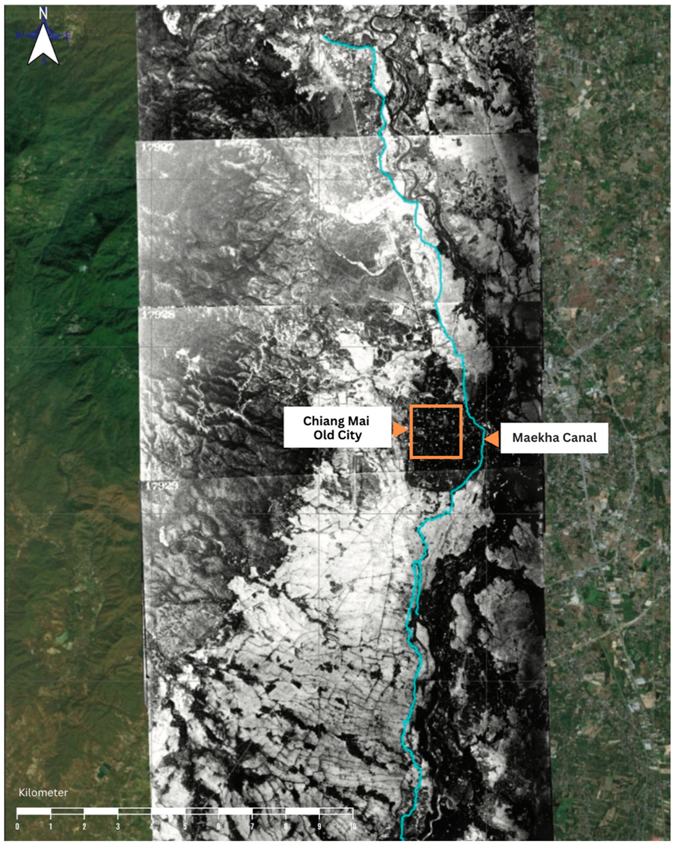
Figure 1. The Maekha Canal and its urban context. An aerial photograph overlaid on a satellite map shows the location of the Maekha Canal (traced in blue) in relation to the Chiang Mai Old City. (Adapted from a Royal Thai Air Force photograph).
Conservation 05 00045 g001
Figure 2. Conceptual framework for co-producing living cultural infrastructure. The framework synthesizes four pillars (Urban Ethnobotany, Participatory Design, Biocultural Stewardship, and Cultural Ecosystem Service) that are integrated through a central co-production process. This process leads to the outcome of ‘Living Cultural Infrastructure,’ which in turn generates key attributes for a resilient and culturally rooted urban landscape.
Conservation 05 00045 g002
Figure 3. The Maekha Canal and study area within the urban context of Chiang Mai. The map illustrates the location of the Maekha Canal in relation to key hydrological and historical features, including the Ping River and the Chiang Mai Old City moat. The dashed orange line indicates the 3.5 km study area where the research was conducted.
Conservation 05 00045 g003
Figure 4. Chord diagram of ethnobotanical uses and plant families. This diagram visualizes relationships between use categories and plant families, with the width of the outer bands corresponding to the number of species. Connecting chords link a family to a use, and their thickness indicates the number of species involved in that relationship. This visualization highlights the multifunctionality of key families, such as Fabaceae and Moraceae.
Conservation 05 00045 g004
Figure 5. The multifaceted process of community engagement. Key participatory methods were used to gather insights and co-develop the Maekha Canal’s cultural landscape. (A) “Mae Kha Walk Along” events for on-site learning about the canal’s ecology and history. (B) Intergenerational workshops for sharing local histories and co-creating narrative content. (C) Co-design workshops enabling stakeholders to engage in collaborative spatial planning. (D) Community dialogues and presentations hosted at the Mae Kha City Lab, the project’s central learning hub.
Conservation 05 00045 g005
Figure 6. Tangible design outputs for the Maekha Ethnobotanical Trail, co-developed with the community for on-site learning and interpretation. (A) Botanical signage for local plant identification. (B) An illustrative guide for the trail’s eco-tours. (C) A co-designed art mural depicting local flora at a learning point. (D) Ethnobotanical mapping database showing plant distribution. (E) Educational materials analyzing floral biodiversity for workshops.
Conservation 05 00045 g006
Table 1. Distribution of the 149 recorded plant species by growth form and family. The table details the botanical inventory from the Maekha Canal study area, categorizing the 149 species from 71 families into six primary growth forms. For each form, it provides a breakdown of the constituent plant families and the number of species recorded per family.
Growth Form (Species)FamilyNumber of SpeciesGrowth Form (Species)FamilyNumber of SpeciesGrowth Form (Species)FamilyNumber of Species
Tree (61)MORACEAE12Shrub (56)ACANTHACEAE6ClimberCUCURBITACEAE3
FAB.CAESALPINIOIDEAE7 ARACEAE5Plant (15)ARACEAE2
FABACEAE4 ZINGIBERACEAE5 BIGNONIACEAE2
LECYTHIDACEAE3 APOCYNACEAE4 APOCYNACEAE1
MELIACEAE3 RUBIACEAE4 CACTACEAE1
RUTACEAE3 EUPHORBIACEAE3 CONVOLVULACEAE1
ANNONACEAE2 POACEAE3 FABACEAE1
BIGNONIACEAE2 AMARANTHACEAE2 MORACEAE1
BOMBACACEAE2 ASTERACEAE2 PAPLIONIDEAE1
COMBRETACEAE2 CLEOMACEAE2 PIPERACEAE1
EBENACEAE2 LAMIACEAE2 POLYDONACEAE1
EUPHORBIACEAE2 AGAVACEAE1AquaticAPIACEAE1
LYTHRACEAE2 AMARYLLIDACEAE1Plant (4)MARANTACEAE1
RHAMNACEAE2 ARALIACEAE1 PONTEDERIACEAE1
SAPOTACEAE2 ASCLEPIADACEAE1 SCROPHULARIACEAE1
ANACARDIACEAE1 BORAGINACEAE1GroundCOMMELINACEAE2
ARECACEAE1 CANNACEAE1Cover (12)LAMIACEAE2
AVERRHOACEAE1 COMMELINACEAE1 PORTULACACEAE2
BORAGINACEAE1 CUCURBITACEAE1 COMPOSIEA1
CARICACEAE1 CYPERACEAE1 FABACEAE1
CUPRESSACEAE1 DRACAENACEAE1 GESNERIACEAE1
DRACAENACEAE1 FABACEAE1 LILIACEAE1
LAURACEAE1 GESNERIACEAE1 PANDANACEAE1
FAB.MIMOSOIDEAE1 LYTHRACEAE1 POACEAE1
FSB.PAPILIONOIDEAE1 MALPIGHIACEAE1 URTICACEAE1
MAGNOLIACEAE1 MALVACEAE1
MALVACEAE1 MARANTACEAE1EpiphyticPOLYPODIACEAE1
MIMOSACEAE1 NYCTAGNACEAE1Plant (1)
MORINGACEAE1 OLEACEAE1
MUNTINGIACEAE1 PALMAE1
MUSACEAE1 PANDANACEAE1
MYRTACEAE1 PHYTOLACCACEAE1
PALMAE1 PLUMBAGINACEAE1
PHYLLANTHACEAE1 RUTACEAE1
SAPINDACEAE1 SCROPHULARIACEAE1
VERBENACEAE1 VERBENACEAE1
Total149Species
Table 2. Summary of community engagement activities and participants.
Engagement ActivityDescriptionParticipants
Ethnobotanical SurveyIn-depth semi-structured interviews and transect walks to document local plant knowledge, uses, and oral histories.20 key informants (community elders, healers, and gardeners aged 40–85).
Co-Design SessionsA series of interactive workshops to co-develop the trail’s narrative, interpretive features, and spatial layout.Broader community members, including local artisans, youth groups, and informal vendors.
Public ForumsA series of four public meetings to gather diverse insights, discuss challenges such as land tenure, and build consensus on the revitalization strategy.Residents, business owners, and local stakeholders from different zones along the canal.
“Mae Kha Walk Along” SeriesPublicly held themed walks along the canal to share knowledge about ecology and history, and to train community storytellers.General public, residents, and community youth.
Household PrototypesCo-development of prototypes for household-level green space and wastewater management.80 households from the canal-side communities.
Table 3. The evolving role of the landscape architect in community-engaged design.
Traditional Role
(Top–Down Model)
Evolving Role
(Co-Production Model)
Master Planner: acts as a top–down planner who views the community as a subject of design, rather than a co-author.Facilitator of Community Memory: creates processes (e.g., workshops, storytelling) to surface and weave localized knowledge and community memory into the design, e.g., conducting ethnobotanical interviews with 20 community elders and establishing the “community storyteller” program.
Technical Expert: operates primarily as an expert, prioritizing professionalized or scientific knowledge over local and embedded wisdom.Curator of Living Heritage: selects and arranges biocultural elements (plants, materials, narratives) to preserve living heritage and make it accessible and meaningful, e.g., curating the 149 documented plant species and their narratives into the trail’s learning points, botanical signage, and the Mae Kha Vegetation Map.
Designer of Form and Aesthetics: focuses on the final aesthetic outcome and ecological function, often detached from the deep cultural context and social meaning.Co-producer of Civic Space: shares agency and decision-making power with the community to collectively shape public space and its ongoing meaning, e.g., engaging residents, youth, and artisans in co-design sessions to determine the trail’s spatial layout and interpretive features.
Works within “Invited” Spaces: operates within formal, pre-defined spaces of participation that are structured by institutions.Nurtures “Invented” Spaces: recognizes and supports organic, community-led spaces of participation that emerge from grassroots initiatives and resistance, e.g., structuring the project to build upon and provide resources for the pre-existing, grassroots “Imagine Maekha” initiative.
Disclaimer/Publisher’s Note: The statements, opinions and data contained in all publications are solely those of the individual author(s) and contributor(s) and not of MDPI and/or the editor(s). MDPI and/or the editor(s) disclaim responsibility for any injury to people or property resulting from any ideas, methods, instructions or products referred to in the content.