Article

Quantifying Forest Structural and Functional Responses to Fire Severity Using Multi-Source Remotely Sensed Data

by
Kangsan Lee
1,2,*,
Willem J. D. van Leeuwen
1,3 and
Donald A. Falk
3
1
School of Geography, Development & Environment, University of Arizona, Tucson, AZ 85721, USA
2
Division of Forestry, Minnesota Department of Natural Resources, St. Paul, MN 55155, USA
3
School of Natural Resources and the Environment, University of Arizona, Tucson, AZ 85721, USA
*
Author to whom correspondence should be addressed.
Geographies 2025, 5(3), 30; https://doi.org/10.3390/geographies5030030
Submission received: 10 May 2025 / Revised: 25 June 2025 / Accepted: 27 June 2025 / Published: 30 June 2025

Abstract

Wildfires play a pivotal role in shaping and regulating the structural characteristics of forest ecosystems. This study examined post-fire vegetation dynamics following the 2020 Bighorn Fire in the Santa Catalina Mountains, Arizona, USA, by integrating pre- and post-fire airborne LiDAR data with Landsat-derived burn severity indices from 2019 to 2024. We analyzed structural and functional vegetation traits across 12,500 hectares to assess the changes pre- to post-fire, and to evaluate how these changes were influenced by the burn severity. We applied a correlation analysis to explore the relationships among the structural variables across different vegetation cover types. Non-parametric LOESS regression revealed that the dNBR was more strongly associated with changes in the tree density than with vertical structural attributes. The functional recovery, indicated by the NDVI, generally outpaced the structural recovery captured by the NBR. Densely forested areas experienced greater declines in vegetation volumes and slower regeneration, whereas herbaceous and sparsely vegetated areas showed a more rapid, but compositionally distinct, recovery. The divergence between the NDVI and NBR trajectories underscores the importance of integrating structural and functional indicators to comprehensively assess the post-fire ecosystem resilience and inform targeted restoration efforts.

1. Introduction

Wildfires play key roles in the dynamics of ecosystems, by partially or wholly eliminating biomass and influencing the composition of vegetation, water, sediment regimes, and nutrient cycles after a fire [1]. While naturally integrated into episodic processes that produce dynamic equilibria, fires trigger rapid transformation, leading to complex post-fire trajectories of vegetation recovery [2,3,4]. A comprehensive evaluation of wildfire impacts during an era of a rapidly changing climate is essential for understanding the potential for post-fire ecosystem change.
Metrics of fire intensity and burn severity are essential for quantifying the physical, chemical, and biological transformations that occur in ecosystems following wildfire disturbances [5]. The fire intensity refers to the energy output during the active combustion phases, typically measured through the fireline intensity or flame residence time, and it is closely associated with immediate heat effects on the vegetation and soil [6,7]. In contrast, the burn severity describes the cumulative ecological impact of a fire, encompassing both immediate (first-order) effects and longer-term (second-order) alterations to both the vegetation biomass and the soil properties [5].
The burn severity plays a pivotal role in shaping post-fire ecological processes, as it directly influences vegetation mortality, soil structure, hydrological function, and nutrient cycling [8]. It also exhibits a strong relationship with carbon emissions during and after fire events [9,10], reinforcing its significance as a key metric in fire ecology. Importantly, the burn severity is often used as a predictor of subsequent changes in both structural (e.g., tree density, canopy height) and functional (e.g., vegetation greenness, productivity) ecosystem variables [11], and long-term ecological trajectories [12].
Understanding how ecosystems respond to varying levels of fire severity is critical for informing fuel management strategies [13], modeling fire-related carbon dynamics [14], and anticipating the broader ecological consequences of a fire [15]. However, the burn severity is not solely a function of fire behavior; it is modulated by a range of environmental factors, including the wind speed, relative humidity, terrain features, forest composition and density, and moisture content of both live and dead fuels. These complex interactions make it challenging to characterize the spatial and temporal variability in the burn severity [16,17], underscoring the need for integrated, multi-source remote sensing approaches to capture its full ecological impact.
In this study, we assessed and quantified burn severity by analyzing the effects of the 2020 Bighorn Fire in the Santa Catalina Mountains, Tucson, Arizona, USA, using light detection and ranging (LiDAR) data and satellite imagery acquired before and after the fire. By integrating these multiple remote sensing datasets, we evaluated the burn severity, as measured by the differenced normalized burn ratio (dNBR) from Landsat data, as well as the forest recovery and regrowth trajectories in relation to pre- and post-fire vegetation structural and functional traits. Our central objective was to examine how well variation in burn severity explains pre- and post-fire structural variables (i.e., tree density, tree height), as represented by LiDAR-derived metrics, and functional variables (i.e., greenness and water content), as represented by the NDVI (normalized difference vegetation index) or NBR (normalized burn ratio).
This analysis was intended to help identify the effects of burn severity on significant structural and functional variables, and determine which variables provide additional and complementary insights into the vegetation response and ecosystem recovery. Our approach will assess the applicability of burn severity indices to the unique vegetation and landscape characteristics of the Sky Island bioregion, while identifying key traits that contribute to understanding post-fire recovery dynamics and ecosystem resilience and their relationships to pre-fire traits.

Burn Indices and Forest Environmental Traits
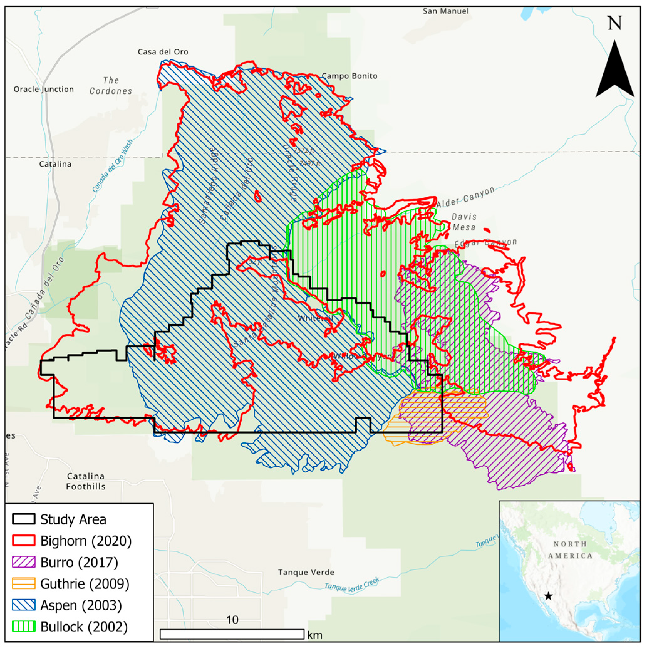
The burn severity was measured using both direct field methods and indirect remote sensing techniques. The composite burn index (CBI) is a field-based method that evaluates visible indicators such as tree scorch, ground cover loss, and soil color changes on specific plots [18]. In contrast, remote sensing methods use satellite imagery to assess changes in the vegetation spectral reflectance before and after a fire, providing a broader spatial analysis [19], as well as quantifying underlying plant drought stress [20].
One of the primary remote sensing metrics is the dNBR, an extension of the NBR. The NBR utilizes near-infrared (NIR) and shortwave infrared (SWIR) bands to detect burned areas by comparing the reflectance of healthy vegetation—which typically has a high NIR and a low SWIR reflectance—to that of burned areas, which exhibit a reduced NIR and an increased SWIR reflectance [18,21]. High NBR values indicate healthy vegetation, while low values signify burned areas lacking in moisture and live vegetation. However, the effectiveness of the NBR diminishes over time as the vegetation regrows [22]. To capture the magnitude of change caused by a fire, the dNBR [21] is calculated, by subtracting the post-fire NBR from the pre-fire NBR.
d N B R = N B R p r e f i r e N B R p o s t f i r e
N B R = N I R S W I R N I R + S W I R
This difference enhances the contrast between the burned and unburned areas by highlighting vegetation and soil changes over time. Higher dNBR values correspond to more severe vegetation loss and soil exposure, making it a robust indicator of the burn severity shortly after fire events.
Satellite-derived burn severity maps, such as those produced using the dNBR, are valuable due to their wide spatial and temporal coverage and relatively fine resolution (30 m), aiding in fire and resource management [23]. Projects such as the Monitoring Trends in Burn Severity (MTBS) and Burned Area Emergency Response (BAER) programs utilize these indices to classify burn severity levels and assess the impacts on the vegetation and soils [24].
The burn severity is influenced by the vegetation types and the forest structure, which affect fire behavior and subsequent ecosystem changes [25,26,27]. A higher burn severity can lead to significant landscape alterations, initiating functional and structural adjustments within forests [2,28] (Figure 1).
Airborne LiDAR offers opportunities to assess the post-fire changes in the forest structure, including the tree density, height, and canopy cover [29]. Airborne LiDAR operates by sending laser pulses from an aircraft to the ground and measuring the time it takes for the pulses to return, allowing for the generation of highly accurate 3D representations of the Earth’s surface, vegetation, and ground structures [30]. When combined with machine learning classification methods, LiDAR data can enhance the interpretations of burn severity by focusing on the post-fire structural and functional diversity [31,32,33].
Recent studies have increasingly employed pre- and post-fire LiDAR datasets to quantify structural vegetation traits and assess fire-induced impacts such as tree mortality and canopy loss [34]. When integrated with spectral indices from satellite imagery, such as the NDVI or the enhanced vegetation index (EVI), these structural indices enable a more comprehensive analysis of the relationships between functional and structural changes across burn severity gradients. This integrative approach enhances our ability to interpret the ecological implications of burn severity and informs more effective post-fire management strategies. We hypothesize that combining LiDAR-derived structural traits with Landsat-based functional indices can improve the interpretation of burn severity assessments and support regionally adaptable restoration planning. To evaluate this hypothesis, we examined how well the dNBR predicts post-fire changes in structural and functional traits across various vegetation cover types, thereby providing insight into what the dNBR represents in terms of ecological recovery trajectories.

2. Study Area

Until the late 19th century, most forests and woodlands in the southwestern United States maintained fire regimes characterized by frequent, low-intensity fires occurring every 5–20 years [35,36]. These fires were ignited primarily by lightning, supplemented by Native American practices [35,37,38]. However, significant changes during the 20th century in land management practices, particularly livestock grazing and fire exclusion, drastically altered fire regimes and forest structures [39,40,41]. Urban expansion, agricultural activities, and the elimination of indigenous human populations disrupted natural fire cycles and fuel distribution, leading to an accumulation of fuel and the proliferation of fire-prone non-native species such as cheatgrass, resulting in more devastating wildfires [42,43,44].
The winter precipitation in 2019–2020 was above average, increasing fine fuel growth. By June of 2020, southern Arizona, including the Santa Catalina Mountains, faced severe drought conditions, with below-average precipitation and rising temperatures [45]. The Palmer drought severity index (PDSI) indicated severe drought with a value of −2.20 in June 2020, compared to the long-term mean of the 20-year average for June (−2.42). These conditions set the stage for the intense wildfires that followed [46].
The study site was the southern Santa Catalina Mountains, one of the Arizona Sky Islands (Lat: 32.4° N, Long: −110.8° E; Figure 2). These mountains are characterized by rugged topography, with steep slopes and deep canyons [47]. The highest peak, Mt. Lemmon, reaches an elevation of 2791 m above sea level, with an elevation change of 1942 m from the base. The region has a semi-arid climate, with its annual precipitation ranging from 300 mm at lower elevations to 750 mm at higher elevations [48]. The precipitation is bi-seasonal, peaking in winter (December to March) from Pacific storms and in summer (June to September) from monsoonal moisture originating from the Gulf of Mexico [49].
The Santa Catalina Mountains host diverse vegetation, including mixed coniferous forests on the north-facing slopes at high elevations, with species such as Douglas fir (Pseudotsuga menziesii), southwestern white pine (Pinus strobiformis), and white fir (Abies concolor). The south-facing slopes at these elevations support mixed-conifer forests along with stands of ponderosa pine. In deep canyons, especially those with water, hardwood forests thrive, containing species like bigtooth maple (Acer grandidentatum), aspen (Populus tremuloides), New Mexico locust (Robinia Neomexicana), Arizona walnut (Juglans major), Gambel oak (Quercus gambelii), and velvet ash (Fraxinus velutina) [50,51]. Lower-elevation areas consist predominantly of desert grasslands, including Agave schottii, Haplopappus laricifolius, and various grasses, as well as Sonoran Desert thornscrub vegetation characteristic of mountain slopes (specifically, the north-slope shrub morphologies and the south-slope spinose-suffrutescent morphologies). Upper (Cercidium microphyllum, Franseria deltoidea) and lower bajada desert vegetation (Larrea tridentata) is present [51,52].
Over the past 20 years, the Catalina Mountains have experienced multiple significant wildfires (Figure 2). In 2002, the Bullock Fire burned approximately 11,722 hectares in the eastern Catalinas, followed by the 2003 Aspen Fire, which burned 28,081 hectares in the western section of the range, with minimal overlap with the Bullock Fire [53]. These fires resulted in complex severity mosaics, with vegetation recovery occurring through seedlings or root sprouts in some areas, while other areas with a high mortality experienced slower conifer recovery or vegetation conversion [54,55]. The subsequent fires include the 2009 Guthrie Fire (1966 ha) and the 2017 Burro Fire (11,059 ha), which reburned parts of the previous fire footprints. The most recent significant event was the 2020 Bighorn Fire, which burned 48,157 hectares, affecting much of the mid- and upper-elevation forest areas and reburning large areas of previous fires [56]. The Bighorn Fire area was likely shaped by prior fires, which influenced the vegetation, the fuel loads, and the severity of the recent wildfire [57].

3. Research Methods

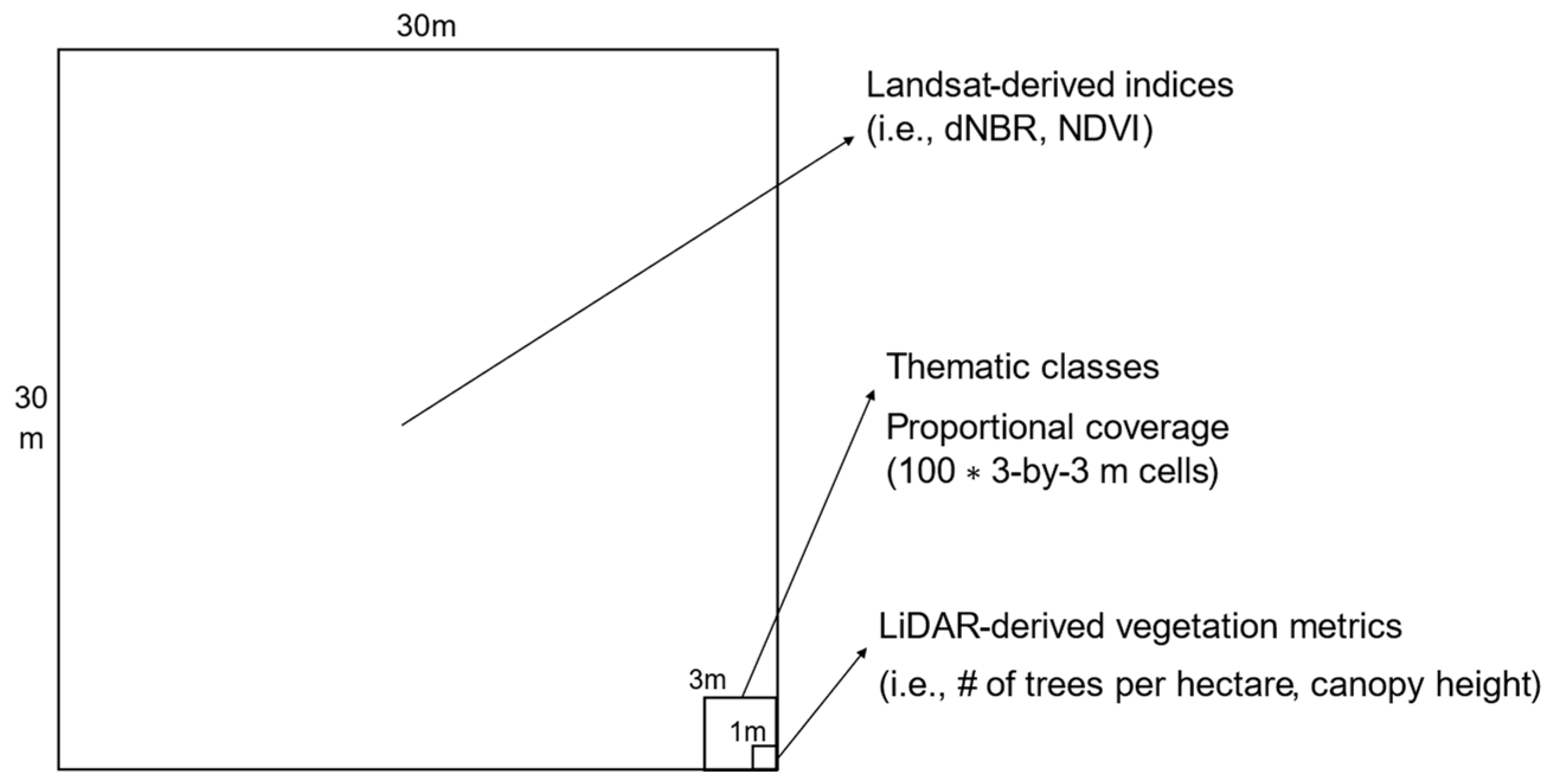
3.1. Data Acquisition

We utilized a multi-source remote sensing approach to examine the post-fire vegetation recovery across a 12,500-hectare area. The primary data sources included pre- and post-fire Landsat 8 satellite imagery, PlanetScope high-resolution satellite imagery, and airborne LiDAR datasets.
Landsat 8 acquires data across nine spectral bands in the visible, near-infrared (NIR), and shortwave infrared (SWIR) regions, with a spatial resolution of 30 m for multispectral bands and 15 m for the panchromatic band [58]. Surface reflectance products from Landsat 8 are radiometrically and atmospherically corrected, providing consistent temporal observations suitable for a time-series analysis of vegetation indices. The high radiometric resolution (12-bit) allows for the detection of subtle changes in the surface reflectance, which enhances the sensitivity of indices such as the NDVI and the NBR for monitoring vegetation dynamics and the burn severity.
PlanetScope, operated by Planet Labs, consists of a constellation of nanosatellites that acquire imagery with a near-daily global coverage [59]. Each satellite captures one NIR spectral band and three visible bands at a spatial resolution of approximately 3 m. The high spatial and temporal resolution of PlanetScope imagery makes it particularly useful for fine-scale land cover classifications and change detection in heterogeneous landscapes. In this study, PlanetScope imagery complemented the Landsat data by providing detailed surface information that was instrumental in delineating vegetation types and identifying post-fire structural heterogeneity not captured at coarser resolutions.
Landsat 8 data were used to calculate vegetation indices, including the NDVI, NBR, and dNBR. The images were acquired on 14 July 2019 and 1 August 2020. Post-fire Landsat surface reflectance imagery was obtained through the Google Earth Engine platform for the analysis (Appendix A). PlanetScope imagery with a 3 m resolution was used to support the land cover classification. Pre-fire LiDAR data were acquired from the USGS 3D Elevation Program (3DEP) between March and May 2019, meeting the 3DEP specifications for 1 m DEM quality. Post-fire LiDAR data were obtained from Pima County in 2020. Both datasets met the ASPRS Quality Level 2 (QL2) standards [60], with a nominal pulse spacing of 0.7 m and an average point density of 2 points per square meter, ensuring their suitability for a detailed analysis of the terrain and vegetation structure. We used these high-resolution aerial LiDAR datasets to derive forest structural metrics such as the canopy height (m), density (stems ha−1), and canopy coverage (%), capitalizing on LiDAR’s ability to measure three-dimensional vegetation characteristics directly with a sub-meter resolution. These metrics were extracted from the point cloud using established, peer-reviewed methods that require minimal calibration and have been validated across a range of forest types [61]. To standardize spatial analysis across datasets, we constructed a 30-by-30 m landscape grid aligned with Landsat pixel boundaries (Figure 3). This grid served as the foundational spatial framework, containing approximately 140,000 cells across the study area. Each grid cell was assigned a comprehensive dataset that included pre- and post-fire burn severity indices from the Burned Area Emergency Response (BAER) and Monitoring Trends in Burn Severity (MTBS) programs, both derived from Landsat 8, as well as data from PlanetScope. In addition, structural and functional vegetation traits derived from aerial LiDAR data were incorporated to capture the three-dimensional forest characteristics. This spatial alignment facilitated the integration and comparison of multiple data sources at a common resolution.

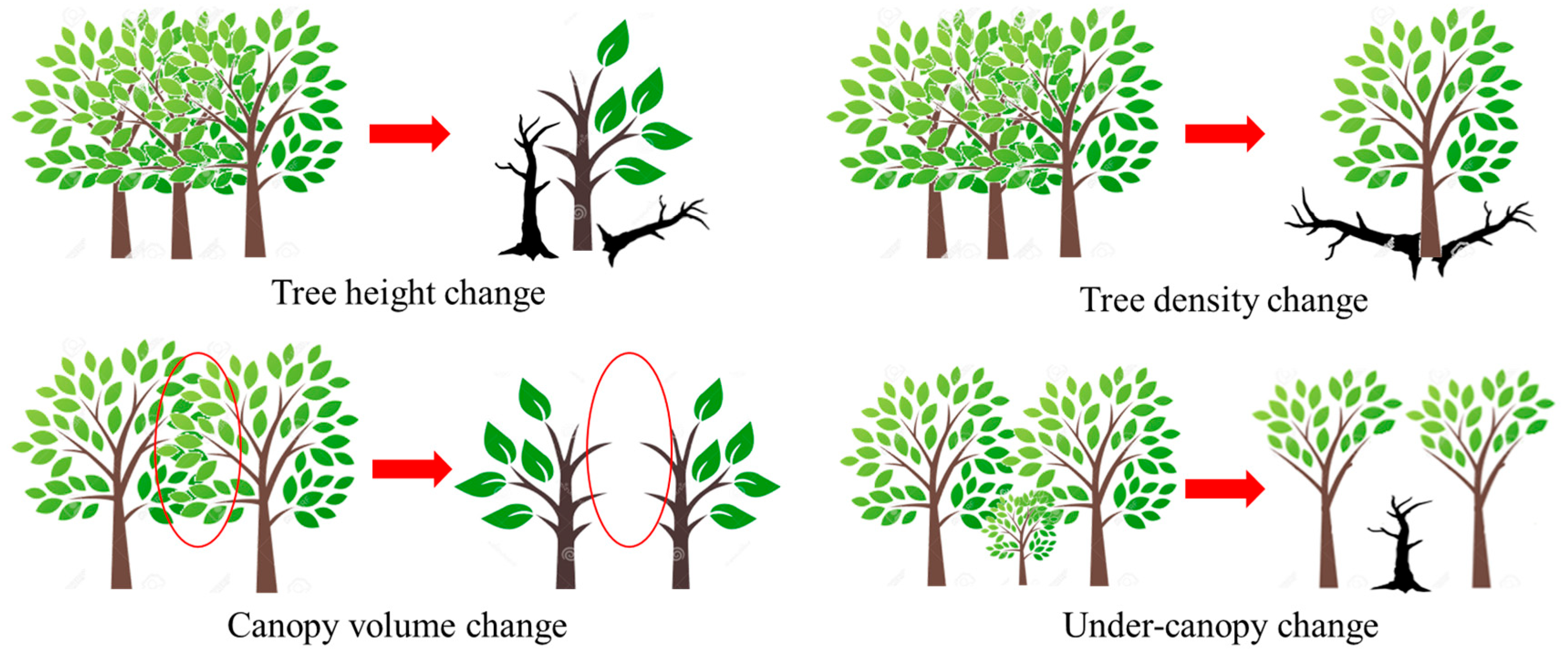
3.2. Derivation of Structural and Functional Indices

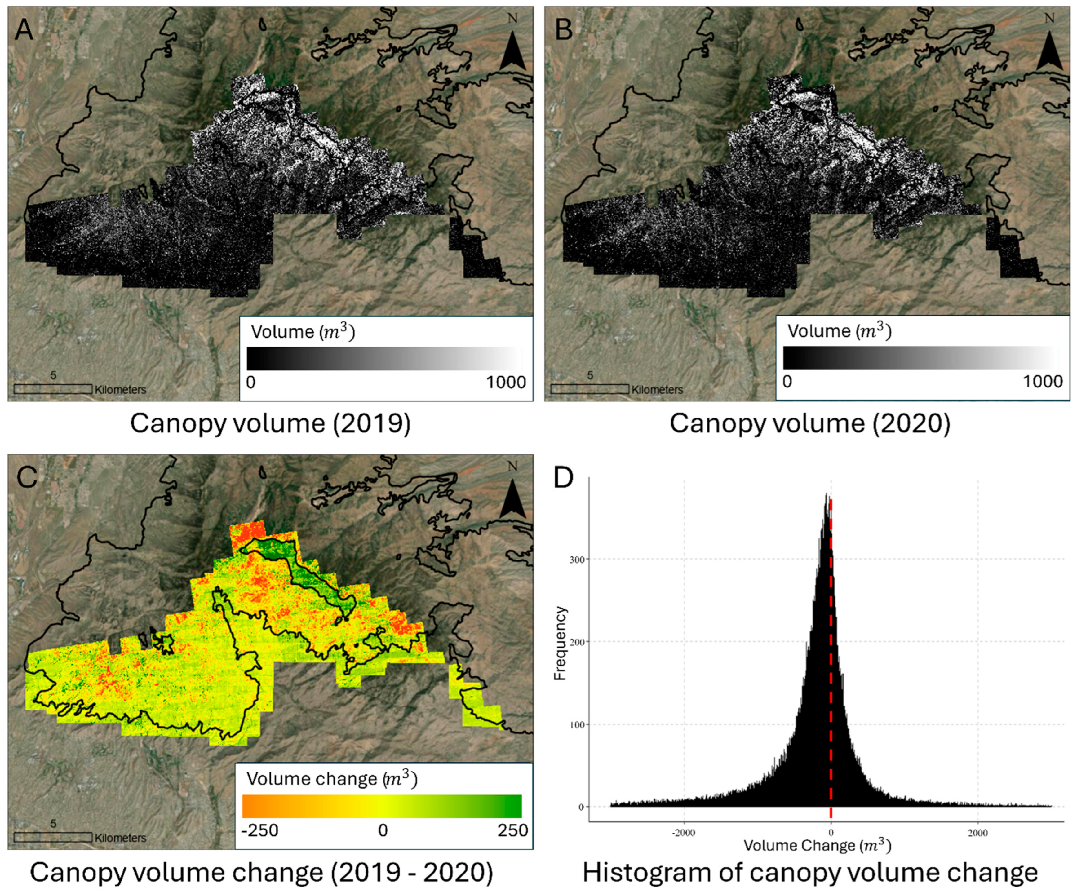
3.2.1. LiDAR-Based Structural Metrics

Airborne LiDAR data were processed and analyzed using the lidR package, which is designed specifically for the analysis of airborne laser scanning (ALS) data [62]. The key processing steps included ground classification, digital terrain and surface model generation, height normalization, and the generation of a canopy height model (CHM). Individual tree segmentation (ITS) was performed to extract structural metrics such as the tree density (trees per hectare), canopy volume change (%), and canopy height diversity. The tree density was estimated by identifying treetops from the CHM using a local maximum (LM) filter, which recognizes treetops as the tallest points within their crowns [61,63,64]. These treetop points were then transformed into density features on the 30 m grid. The canopy volume change was calculated as the relative percentage difference between the two CHMs. The canopy height diversity was calculated as the standard deviation of tree heights within each cell [65]. This suite of LiDAR-derived metrics enabled a fine-scale characterization of the vegetation structure before and after the fire event [66,67,68,69]. Higher values were typically found in areas where the fire scar pattern was irregular. For example, pine trees with a larger diameter at breast height (DBH) may be better able to survive higher-intensity fires compared to those with a smaller DBH that experience scorched burns [70].

3.2.2. Thematic Land Cover Classification

To represent the pre-fire land cover, we implemented a supervised classification approach using 3 m resolution PlanetScope imagery in combination with LiDAR-derived canopy height models. We used the C5.0 decision tree classifier [71], implemented in RStudio (R version 4.4.2), to categorize pixels into three dominant land cover classes (Table 1). This algorithm distinguished vegetated from abiotic features by recursively partitioning the data to maximize information gain [72]. To prevent overfitting resulting from a class imbalance, we applied a 75–25% training–validation split [73], and validated the classification using 58 ground reference points collected across the study area by an unmanned aerial vehicle (UAV) after the fire within a year. We then upscaled the classified 3 m resolution output to the 30 m Landsat-aligned grid, with each cell containing the proportional coverage of the identified thematic classes.

3.2.3. Burn Severity Estimation

The burn severity was quantified by comparing the spectral changes in the pre- and post-fire Landsat 8 imagery. Two standard indices—the NBR and the dNBR—were used to characterize the severity of the vegetation loss, as recommended by the BAER program [21,74,75]. The peak values of the NDVI, NBR, and dNBR were extracted using Google Earth Engine to assess the vegetation conditions immediately following the fire and throughout the recovery period up to Winter 2023. These measures provided insights into both the immediate burn effects and temporal patterns of regrowth.

3.3. Statistical Analysis and Trend Detection

3.3.1. Statistical Analysis

Before assessing the influence of vegetation traits on the burn severity, a preliminary analysis was conducted to evaluate the normality of all the structural and functional variables. This assessment involved a visual inspection of the histograms and the calculation of skewness and kurtosis. The data were considered approximately normal if the distribution shape resembled a normal curve and the absolute value of the skewness and excess kurtosis (kurtosis − 3) was less than 1. The LiDAR-derived variables did not meet the assumptions of normality, while the Landsat-derived variables met those assumptions.
We computed the mean and standard deviation of the NBR and NDVI values before and after the fire to assess the changes in the vegetation conditions. The magnitude of change between the pre- and post-fire datasets reflects the overall impact of the fire severity on the vegetation. A significant difference in the mean values indicates that the fire severity substantially influenced the vegetation characteristics. To evaluate the statistical significance of these differences, a paired t-test was conducted:
t p a i r e d = d ¯ S d n
where
d ¯ = m e a n   o f   t h e   d i f f e r e n c e s   b e t w e e n   p a i r e d   o b s e r v a t i o n s
  S d = s t a n d a r d   d e v i a t i o n   o f   t h e   d i f f e r e n c e s
  n = n u m b e r   o f   p a i r e d   o b s e r v a t i o n s
Because the LiDAR-derived metrics were not normally distributed, we employed non-parametric statistical approaches to examine the relationship between the dNBR values and the pre-fire vegetation structure and function. Local regression, also known as LOESS (locally estimated scatterplot smoothing), is a non-parametric technique that fits simple models to localized subsets of the data [76]. Unlike traditional linear regression, which estimates a single global relationship, LOESS captures potential non-linear patterns by applying weighted least squares within a moving window defined by neighboring data points [77]. The degree of smoothing is controlled by a span parameter, which determines the proportion of data used in each local fit. This approach is particularly useful in ecological and remote sensing studies, where the relationships between variables may vary across different ranges of the data or exhibit non-linear behavior [78]. In this analysis, LOESS was applied to assess how well the dNBR values explained the variation in the vegetation structure and function across different pre-fire conditions.
We performed a correlation analysis (r) to determine how dependent variables (tree density change, tree volume change, and tree diversity (standard deviation of height) change) were co-related with each other.
r = Σ [ ( X i X ¯ ) ( Y i Y ¯ ) ] / Σ [ ( X i X ¯ ) 2 × ( Y i Y ¯ ) 2 ]
where
X i   a n d   Y i = i n d i v i d u a l   s a m p l e   v a l u e s
X ¯ = m e a n   o f   v a r i a b l e   X
Y ¯ = m e a n   o f   v a r i a b l e   Y

3.3.2. Time-Series Trend Analysis

To investigate the functional changes in the vegetation over time, we performed a time-series analysis of the NDVI and NBR values derived from annual Landsat imagery from 2019 to 2024, at a resolution of 30 m. Two indicators were computed: the annual maximum NDVI, which captures the peak seasonal greenness and serves as an indicator of productivity and regrowth potential [79], and the annual average NDVI, which reflects the general health and stability of vegetation throughout the year, offering a more integrated measure of the ecosystem condition. While structural variables were available only for 2019 and 2020 due to the limited temporal coverage of the LiDAR data, the functional recovery was assessed continuously for 2019–2024 using satellite-based indices. By comparing the trends in the maximum and average NDVI, it was possible to distinguish between full and partial vegetation recovery. A concurrent increase in both indices suggested successful regrowth, whereas a mismatch—such as an increase in the maximum NDVI without a corresponding rise in the average NDVI—indicated incomplete or delayed recovery, potentially due to limiting environmental factors. These analyses provided insight into the recovery trajectories in relation to the pre-fire vegetation structure and function [80].

4. Results and Discussion

4.1. Functional and Structural Trait Assessment by Land Cover Classification

Both the NBR and NDVI generally decreased following the fire, regardless of the vegetation cover types (Table 2). Areas with greater vegetation cover exhibited greater declines in the NBR and NDVI after the fire compared to areas with less vegetation cover or bare ground (p < 0.05). Non-vegetated areas, such as bare ground, consistently displayed the lowest values for both the NBR and NDVI.
In herbaceous-dominated areas, although the observed changes were not statistically significant (p > 0.05), the NDVI values were consistently higher than those recorded in other vegetation cover types. These areas demonstrated a greater sensitivity to Landsat-derived vegetation indices during post-fire regrowth, particularly in the first year following the fire, compared to other land cover categories. The average tree height per 30-by-30 m pixel declined as the percentage of vegetation cover decreased, when comparing the pre- and post-fire values (p < 0.05).
The tree height declined across all the land cover classes following the fire, with more pronounced reductions in vegetated areas compared to less-vegetated areas (Table 3). The tree density in the study area increased with elevation, reflecting the area’s distinct environmental characteristics (p < 0.05). The mixed conifer forests at the highest elevations and on north-facing slopes, along with the ponderosa pines on high-elevation south-facing slopes, had the greatest tree densities (Table 1). The tree density declined more in areas with less vegetation cover (p < 0.05); the decline in the density was 9% in areas with vegetation coverage exceeding 80%, whereas it increased to 15% in areas with less than 40% vegetation coverage (p < 0.05). Notably, the rate of density decline was more pronounced in sparsely vegetated areas than in densely vegetated regions (p < 0.05). Areas with denser vegetation generally showed higher σ values after a fire, compared to less vegetated or non-vegetated areas (p < 0.05).
The canopy volume change, derived from comparisons of the USGS data (2019) and aerial LiDAR data (2020), indicated a significant (p < 0.001) reduction in the vegetation volume across most areas within the Bighorn Fire boundary (Figure 4). A few regions, highlighted in green (Figure 4, Map C), exhibited increases in the vegetation volume. These areas correspond to unburned zones that were maintained intentionally to protect nearby communities and research facilities near the summit of Mt. Lemmon. The remainder of the study area was affected by variable fire severity during the Bighorn Fire.

4.2. Relationship Between Functional and Structural Variables and Burn Severity Indices

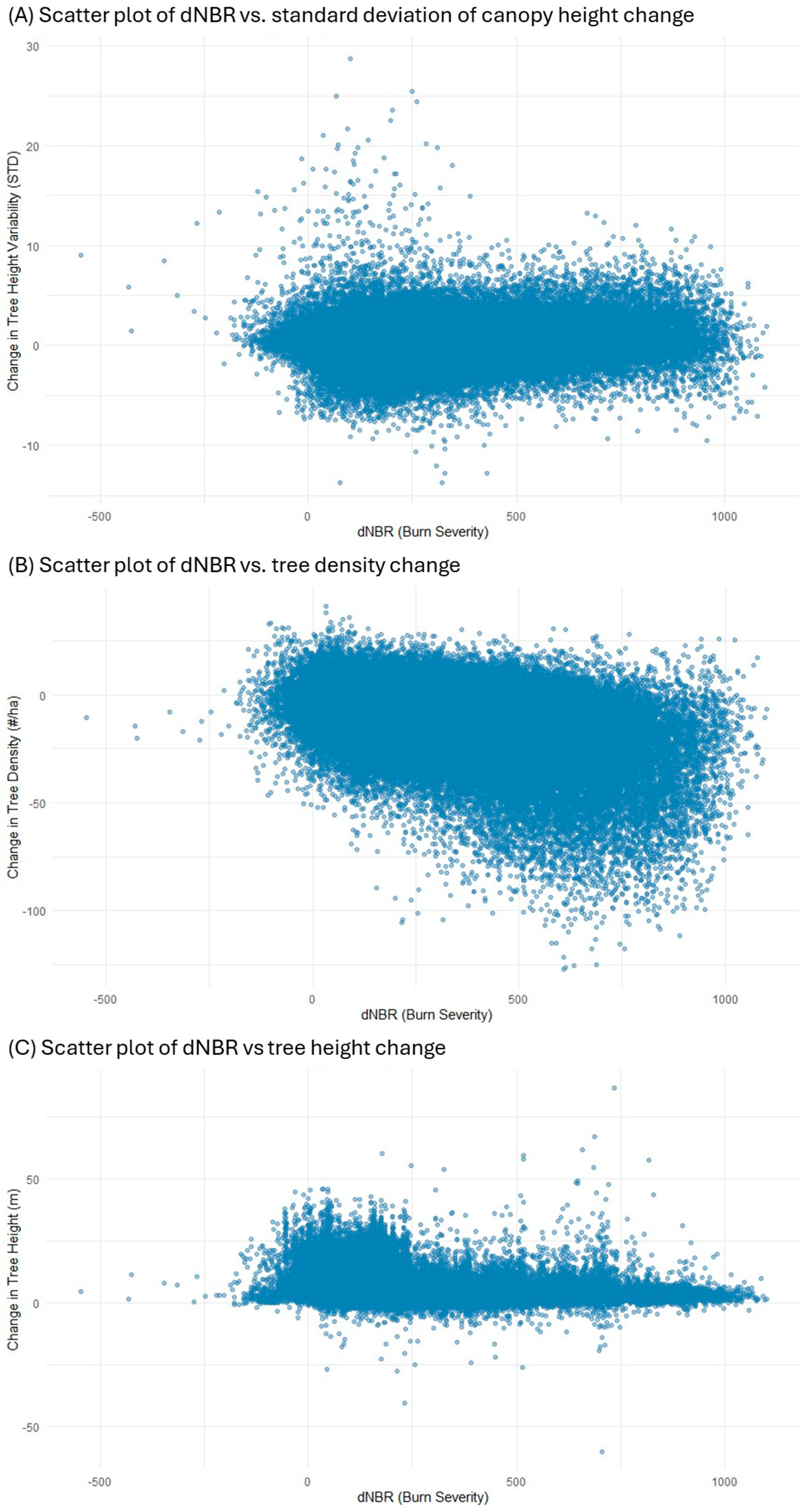
4.2.1. Local Regression Analysis

The results of the local regression model (LOESS) are summarized in Table 4. For areas with forest cover exceeding 80%, the residual standard error (RSE) was 13.76 for the tree density change, 1.79 for the standard deviation of the tree height change, and 4.04 for the mean tree height change. The corresponding R 2 values were 0.287, 0.060, and 0.089, respectively, indicating that, while the tree density change was moderately explained by the burn severity, vertical structural traits showed weak associations. In the 60–80% forest cover group, the RSEs were slightly lower at 13.62, 1.64, and 4.06 ( R 2 = 0.292, 0.046, and 0.094). For areas with 40–60% forest cover, the RSEs decreased to 13.44, 1.49, and 4.30, respectively; the R 2 values remained low (0.254, 0.040, and 0.093), suggesting a limited explanatory power of the burn severity for structural changes in these regions.
In zones with 20–40% forest cover, the tree density change exhibited the lowest RSE among the vegetated groups (11.67), with an R 2 of 0.170, indicating reduced residual variation, but still some model explanatory power. The standard deviation of the tree height had an RSE of 1.36 and an R 2 of 0.041, while the mean tree height change had the highest RSE (4.56) and a modest R 2 of 0.097. In bare ground areas with over 80% cover, the RSEs were notably lower for the tree density change (10.01) and height variability (1.16), but the R 2 values were near zero (0.022 and 0.007), suggesting weak or negligible relationships between the burn severity and the structural response. Interestingly, the tree height changes in the bare ground areas showed a relatively higher RSE (5.04) and a low R 2 of 0.075, indicating greater unexplained variability in the height recovery.
Herbaceous-dominated areas (>80% cover) exhibited a tree density RSE of 13.65 and an R 2 of 0.210, reflecting a slightly stronger association compared to bare ground. The standard deviation of the tree height had the highest RSE among all the groups (2.51) and an R 2 of 0.141, while the mean tree height change showed the lowest RSE (2.26) and a relatively higher R 2 of 0.131. These findings indicate that, although LOESS models capture the general trends in post-fire structural changes, the overall explanatory power of the burn severity remains modest, particularly for vertical structure metrics.

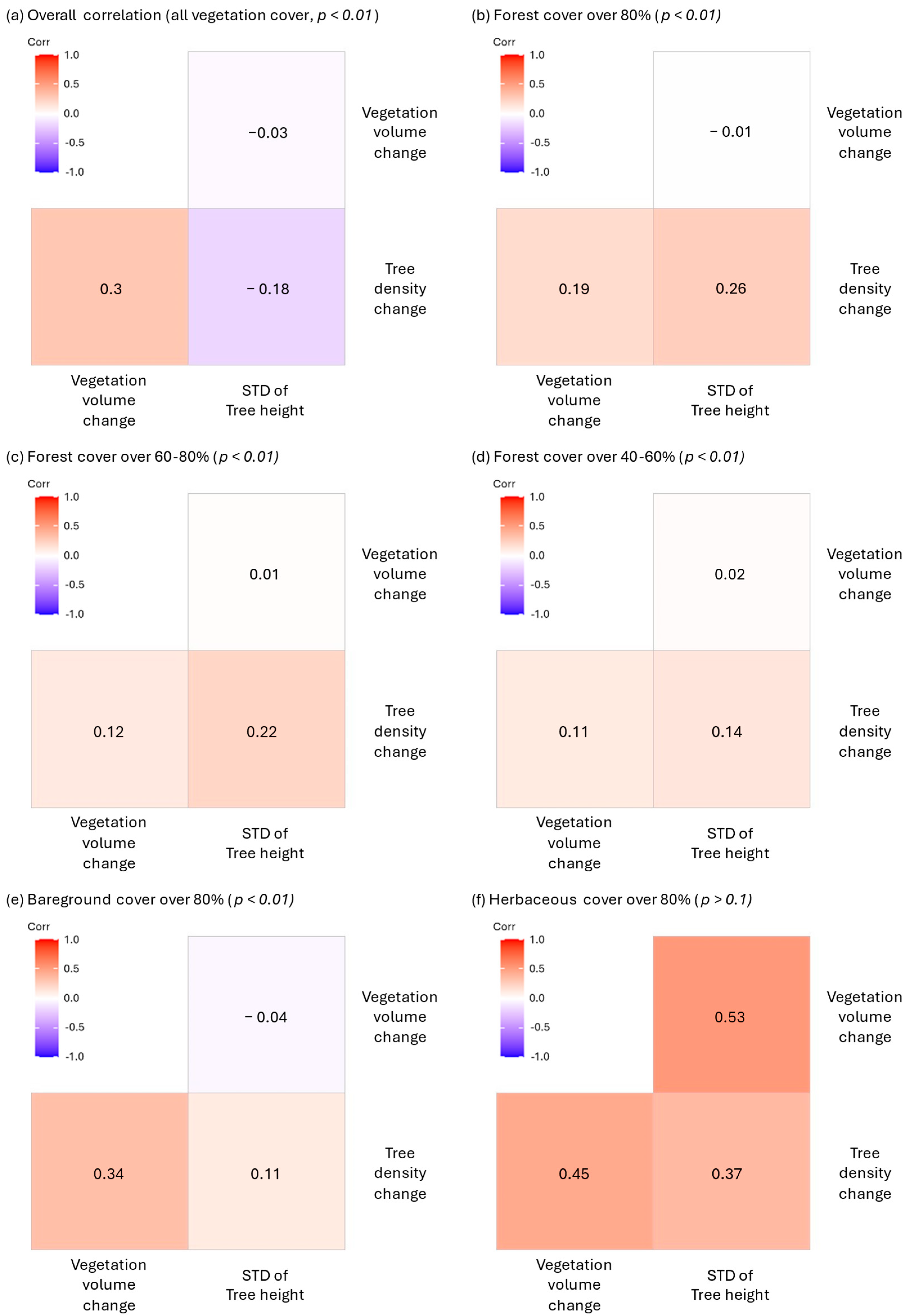
4.2.2. Correlation Analysis

Across all the vegetation types, correlation analyses revealed consistently weak to moderate relationships among the changes in tree density, the vegetation volume, and the standard deviation (STD) of the tree height (Figure 5). In the combined dataset, representing all vegetation cover types, the tree density change showed a moderate positive correlation with the vegetation volume change (r = 0.30) and a weak negative correlation with the height variability (r = −0.18), suggesting that areas with increasing density are moderately associated with biomass gain, but tend to exhibit a more uniform canopy structure. Among the stratified vegetation groups, these relationships varied in magnitude. For high-density live vegetation cover (>80%), a weak positive correlation was observed between the tree density change and both the vegetation volume r = 0.19) and the height STD (r = 0.26), indicating some structural complexity in densely vegetated areas. Similar trends persisted in the 60–80% and 40–60% live vegetation categories, although with slightly lower correlation coefficients across all variables (ranging from 0.01 to 0.22), reflecting a reduction in the structural coherence in moderately vegetated areas.
In bare-ground-dominated regions (over 80%), a moderate correlation between tree density changes and the vegetation volume change (r = 0.34) was observed, while other correlations remained weak or negligible. Interestingly, this moderate association may reflect patchy regrowth or localized biomass accumulation following a disturbance. In herbaceous-dominated areas (>80% herbaceous cover), the tree density change was correlated moderately with both the vegetation volume (r = 0.45) and the height STD (r = 0.37), and the vegetation volume change was correlated moderately with the height STD (r = 0.53). However, these correlations were not statistically significant, likely due to the small sample size in this group. Overall, the strongest and most consistent relationships emerged between the tree density and the vegetation volume change, whereas the variability in the tree height exhibited weak and inconsistent associations across vegetation types. These findings suggest that, while biomass accumulation may align with increases in tree density, vertical structural heterogeneity is less predictably linked to other forest structure changes following a disturbance.

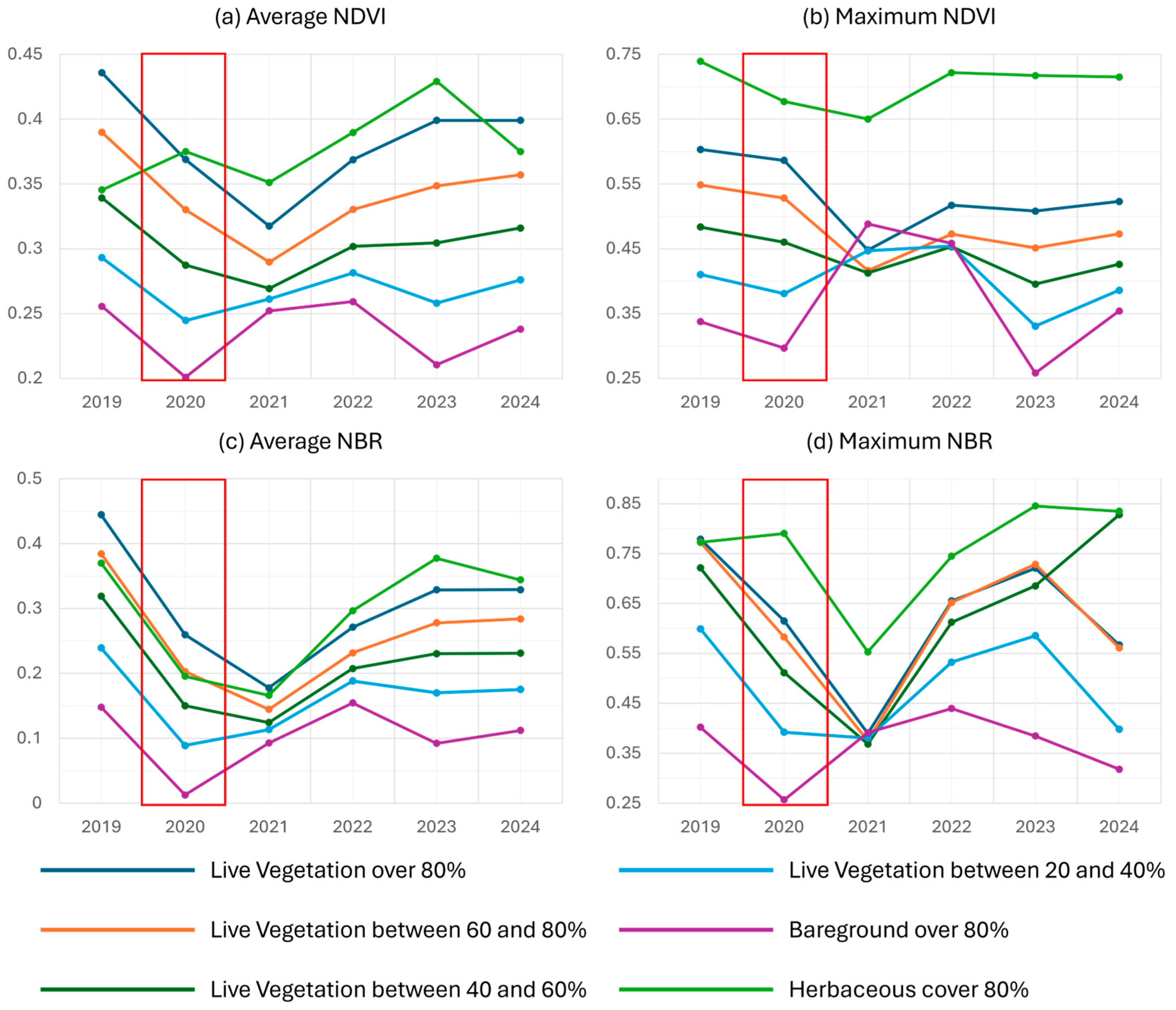
4.3. NDVI and NBR Trend Analysis

A noticeable decline in the average NDVI occurred in 2020, followed by a gradual recovery beginning in 2021 and continuing through 2024, suggesting fire-induced stress and subsequent regrowth (Figure 6). This trend was particularly evident in sparsely vegetated areas such as herbaceous cover, which demonstrated a rapid and sustained recovery, with the average NDVI values peaking in 2023.
The maximum NDVI values, representing the peak vegetation greenness under optimal conditions, further support these trends. The herbaceous areas consistently showed the highest maximum NDVI values, exceeding 0.7 across all years, underscoring their rapid post-fire recovery. Similarly, the NBR values, which indicate the vegetation moisture content and fire susceptibility, revealed distinct temporal and spatial recovery patterns. Bare ground consistently exhibited the lowest average NBR values, with a sharp decline in 2020, reflecting extreme dryness and a heightened fire vulnerability. A marked decrease in the NBR across all land cover types in 2021, aligned with reduced NDVI values, points to a particularly dry year that hindered vegetation recovery. However, the rising NBR values from 2022 to 2024 suggest improved moisture retention and resilience across vegetation types.

5. Discussion

Our comparison of the NDVI and NBR recovery trajectories revealed critical divergence. The NDVI is highly sensitive to the presence of herbaceous regrowth and may, therefore, overestimate the recovery in forested ecosystems where the canopy structure remains degraded. In contrast, the NBR—being more responsive to moisture content and canopy integrity—offers a complementary view of longer-term ecosystem resilience. This finding reinforces the importance of using both structural and functional indicators for a more comprehensive evaluation of post-fire recovery.
The observed divergence between the NDVI and the NBR likely arose from fundamental differences in what these indices measure in response to wildfire impacts. The NDVI primarily quantifies vegetation greenness and chlorophyll activity, focusing predominantly on live foliage [21]. As a result, the NDVI can underestimate the fire severity when the foliage remains intact or rapidly regenerates, even if significant structural damage and mortality occur at lower strata or the ground level [5].
Conversely, the NBR captures more nuanced changes associated with fire-induced vegetation moisture loss, canopy and understory damage, and surface fuel consumption [81]. The NBR is sensitive to structural disruption, exposed soil surfaces, and the drying of vegetation materials, thus potentially reflecting the immediate post-fire severity compared to the NDVI [5]. This differential sensitivity explains why areas might exhibit a lower NDVI-based severity, but a higher NBR-based severity, highlighting the distinct ecological processes captured by each index.
The ecological explanations for the relationship between the tree density and the vertical forest structure in fire-affected ecosystems include several key mechanisms: Fires generally eliminate smaller trees and understory vegetation due to their thinner bark, lower canopy base heights, and greater vulnerability to heat-induced damage compared to taller, more mature trees. Consequently, small-tree-dominated stands often experience higher mortality rates, altering the density, patch size, and structure significantly. Dense stands of smaller trees enhance vertical fuel continuity (“ladder fuels”), facilitating fire spread from the surface into tree crowns, thereby intensifying canopy mortality. In contrast, forests characterized by fewer, larger, and taller trees often possess discontinuous fuel structures, limiting the fire severity. Mature, taller trees typically possess adaptations such as thicker bark, deeper rooting systems, and greater stored resources, enhancing their resilience to fire stress relative to smaller, younger individuals. These physiological traits result in differential post-fire survival, promoting structural complexity and lower-density mature stands post-fire [82,83,84]. Integrating these ecological mechanisms clarifies the observed variations in the tree density and vertical structure following fires, reinforcing the importance of forest structural characteristics in determining fire effects.

6. Conclusions

This study investigated the relationships between the burn severity, as quantified by the differenced normalized burn ratio (dNBR), and both structural and functional vegetation traits, such as the NDVI and the canopy height derived primarily from LiDAR and satellite data. While LiDAR provides high-resolution structural information, its spatial coverage was incomplete across the entire mountain range, limiting the generalizability of the results for some ecosystems. Given the variability in the dominant vegetation species across land cover classifications, the accuracy and ecological interpretation of LiDAR-derived metrics may differ by vegetation type. Nonetheless, the analysis revealed meaningful patterns in how forest structure and function respond to fires, offering broader insight into post-fire vegetation dynamics.
The spatial distribution of the burn severity was highly heterogeneous, with the most severely burned areas concentrated on south-facing slopes (Figure 4C). This uneven distribution occurred despite similar topographic conditions across the landscape, suggesting that the pre-fire vegetation structure played a critical role in influencing fire behavior. Notably, areas with a lower canopy height exhibited more uniform burn patterns, indicating that the forest structure can mediate fire spread and intensity. These findings underscore the value of quantifying the pre-fire vegetation conditions when evaluating the burn severity and predicting recovery trajectories, as we were able to accomplish here.
The LOESS-based regression analyses indicated that the explanatory power of the dNBR for predicting post-fire structural changes varied by vegetation cover type. Densely forested regions (>80% canopy cover) experienced higher levels of structural degradation and displayed stronger associations between the burn severity and changes in the tree density and height variability. In contrast, non-forested areas, including bare ground and herbaceous cover, exhibited a greater structural resilience. Herbaceous-dominated regions demonstrated notable post-fire recovery, with improvements in both structural (e.g., tree density) and functional (e.g., NDVI) metrics, suggesting the rapid regrowth of grass and other ground-level vegetation.
Immediately following the fire, both functional and structural traits declined, as detected by LiDAR and satellite indices. However, the magnitude of change varied by vegetation type. Forested areas showed a sharper decline in functional indicators such as the NDVI (over 30%) compared to structural attributes like tree density (approximately 10%). This discrepancy highlights the importance of integrating multiple indicators when assessing fire impacts. Relying on a single metric, such as the NDVI or canopy height, may overlook key aspects of ecosystem damage or recovery, as structural and functional changes may follow divergent trajectories.
The relationship between structural and functional traits differed by vegetation density. Stronger correlations between structural and functional metrics were observed in areas with a high canopy cover, whereas weaker associations characterized sparsely vegetated or bare-ground regions. A time-series analysis of the NDVI and NBR revealed that functional recovery, as indicated by increasing greenness, does not always correspond to structural recovery (e.g., canopy height or biomass accumulation). This underscores the benefits of a multidimensional approach to post-fire assessments, combining both structural and functional indicators to characterize ecosystem recovery more accurately.
The herbaceous areas showed particularly distinct patterns in their temporal vegetation dynamics. An analysis of 44 satellite scenes from 2019 and 47 from 2020 (Appendix A) revealed that, while the annual maximum NDVI increased post-fire, the annual average NDVI declined. This pattern suggests rapid colonization by fast-growing species, including perennials, grasses, or potentially invasive species. Such patterns emphasize the value of combining remote sensing time-series and correlation-based analyses to detect nuanced shifts in vegetation function and structure. These insights can support field-based assessments and guide ecological restoration strategies.

Author Contributions

Conceptualization, K.L. and W.J.D.v.L.; methodology, K.L., W.J.D.v.L. and D.A.F.; software, K.L.; validation, K.L.; format analysis, K.L.; investigation, K.L., W.J.D.v.L., and D.A.F.; resource, K.L.; data curation, K.L.; writing—original draft preparation, K.L.; writing—review and editing, W.J.D.v.L. and D.A.F.; visualization, K.L.; supervision, W.J.D.v.L. and D.A.F. project administration, W.J.D.v.L. All authors have read and agreed to the published version of the manuscript.

Funding

This research received no external funding.

Data Availability Statement

The original Landsat8 data presented in the study are openly available in Google Earth Engine Data Catalog at https://developers.google.com/earth-engine/datasets/catalog/landsat-8. The PlanetScope data used in this study are available upon request from the corresponding author, as they are restricted to private, project-specific use only (https://earth.esa.int/eogateway/missions/planetscope). The aerial LiDAR data presented in the study are openly available in OpenTopography (https://opentopography.org/news/pag) and USGS 3DEP program (https://www.usgs.gov/3d-elevation-program). The Bighorn fire data presented in this study are openly available at the Pima County website (https://www.pima.gov/1700/University-of-Arizona-Bighorn-Fire-Data). The original contributions presented in this study are included in the article. Further inquiries can be directed to the corresponding author.

Acknowledgments

The authors gratefully acknowledge Jeff Gillan for his foundational work in analyzing the pre- and post-fire LiDAR and PlanetScope satellite data used to assess the burn severity of the Bighorn Fire. Appreciation is also extended to Andy Honaman for his sustained support in managing the computing infrastructure in the Arizona Remote Sensing Center, which was essential for the efficient processing and storage of the research data.

Conflicts of Interest

The authors declare no conflict of interest.

Appendix A

Table A1. Landsat-8 acquisition dates for the surface reflectance imagery.
PathRowAcquisition Dates (2019)Acquisition Dates (2020)Acquisition Dates (2021)Acquisition Dates (2022)Acquisition Dates (2023)Acquisition Dates (2024)
35381/281/311/11/41/71/10
3/12/161/171/202/81/26
3/174/42/182/52/242/11
4/24/203/62/213/124/15
4/185/63/223/93/285/1
5/45/224/73/254/295/17
6/56/74/234/105/316/2
6/216/235/94/267/26/18
7/77/95/255/127/187/20
7/238/106/106/138/38/5
8/88/266/267/159/48/21
8/249/277/127/3110/69/6
10/1110/137/288/1610/229/22
10/2710/298/299/1711/710/8
12/1411/149/1410/312/910/24
11/3010/1610/19
12/1611/111/411/9
12/311/2012/25
12/612/11
12/22
36371/31/61/81/271/302/18
1/192/72/92/122/153/5
2/205/132/253/163/33/21
3/245/293/294/14/44/6
4/96/144/144/174/204/22
4/256/304/305/195/65/8
5/118/15/166/45/225/24
5/278/176/16/206/77/11
6/289/26/177/66/237/27
7/149/187/197/227/99/13
8/1510/48/48/77/259/29
8/3110/208/208/239/2710/15
10/212/79/59/2410/1310/31
10/1812/239/2110/1010/2912/2
11/310/710/2612/18
11/811/11
12/2611/27
36381/31/61/81/273/31/17
1/192/72/92/124/42/18
2/202/232/253/164/203/21
3/245/134/144/15/64/6
4/95/294/304/175/224/22
4/256/145/165/196/75/8
5/116/306/16/46/235/24
5/277/166/176/207/96/9
8/158/18/47/67/257/11
8/318/178/208/79/277/27
10/29/29/58/2310/138/12
10/189/189/219/2410/299/13
12/510/410/2310/109/29
10/2010/2610/15
11/2111/2411/1110/31
12/711/2712/2
12/1312/18

Appendix B. Scatter Plots for All Variables

Figure A1. The relationship between the dNBR and structural variables varied; however, it was evident that the structural attributes changed as the dNBR increased. Among these variables, the tree density was the most sensitive to the burn severity. To better illustrate these relationships, the forest types were classified, as shown in Table 4.
Geographies 05 00030 g0a1

References

  1. Scott, A.C.; Bowman, D.M.; Bond, W.J.; Pyne, S.J.; Alexander, M.E. Fire on Earth: An Introduction; John Wiley & Sons: Hoboken, NJ, USA, 2013. [Google Scholar]
  2. Seidl, R.; Turner, M.G. Post-disturbance reorganization of forest ecosystems in a changing world. Proc. Natl. Acad. Sci. USA 2022, 119, e2202190119. [Google Scholar] [CrossRef] [PubMed]
  3. Shakesby, R.A. Post-wildfire soil erosion in the Mediterranean: Review and future research directions. Earth-Sci. Rev. 2011, 105, 71–100. [Google Scholar] [CrossRef]
  4. Falk, D.A.; van Mantgem, P.J.; Keeley, J.E.; Gregg, R.M.; Guiterman, C.H.; Tepley, A.J.; Young, D.J.; Marshall, L.A. Mechanisms of forest resilience. For. Ecol. Manag. 2022, 512, 120129. [Google Scholar] [CrossRef]
  5. Keeley, J.E. Fire intensity, fire severity and burn severity: A brief review and suggested usage. Int. J. Wildland Fire 2009, 18, 116–126. [Google Scholar] [CrossRef]
  6. Keeley, J.E.; Zedler, P.H. Large, high-intensity fire events in southern California shrublands: Debunking the fine-grain age patch model. Ecol. Appl. 2009, 19, 69–94. [Google Scholar] [CrossRef]
  7. Keeley, J.E. Fire. In Encyclopedia of Ecology; Jørgensen, S.E., Fath, B.D., Eds.; Academic Press: Oxford, UK, 2008; pp. 1557–1564. [Google Scholar]
  8. McLauchlan, K.K.; Higuera, P.E.; Miesel, J.; Rogers, B.M.; Schweitzer, J.; Shuman, J.K.; Tepley, A.J.; Varner, J.M.; Veblen, T.T.; Adalsteinsson, S.A. Fire as a fundamental ecological process: Research advances and frontiers. J. Ecol. 2020, 108, 2047–2069. [Google Scholar] [CrossRef]
  9. Conard, S.G.; Sukhinin, A.I.; Stocks, B.J.; Cahoon, D.R.; Davidenko, E.P.; Ivanova, G.A. Determining Effects of Area Burned and Fire Severity on Carbon Cycling and Emissions in Siberia. Clim. Change 2002, 55, 197–211. [Google Scholar] [CrossRef]
  10. Hurteau, M.D.; Koch, G.W.; Hungate, B.A. Carbon protection and fire risk reduction: Toward a full accounting of forest carbon offsets. Front. Ecol. Environ. 2008, 6, 493–498. [Google Scholar] [CrossRef]
  11. Kuenzi, A.M.; Fulé, P.Z.; Sieg, C.H. Effects of fire severity and pre-fire stand treatment on plant community recovery after a large wildfire. For. Ecol. Manag. 2008, 255, 855–865. [Google Scholar] [CrossRef]
  12. Shive, K.L.; Preisler, H.K.; Welch, K.R.; Safford, H.D.; Butz, R.J.; O’Hara, K.L.; Stephens, S.L. From the stand scale to the landscape scale: Predicting the spatial patterns of forest regeneration after disturbance. Ecol. Appl. 2018, 28, 1626–1639. [Google Scholar] [CrossRef]
  13. Fernandes, P.M.; Rigolot, E. The fire ecology and management of maritime pine (Pinus pinaster Ait.). For. Ecol. Manag. 2007, 241, 1–13. [Google Scholar] [CrossRef]
  14. Veraverbeke, S.; Rogers, B.; Randerson, J. Daily burned area and carbon emissions from boreal fires in Alaska. Biogeosciences 2015, 12, 3579–3601. [Google Scholar] [CrossRef]
  15. Roces-Díaz, J.V.; Santín, C.; Martínez-Vilalta, J.; Doerr, S.H. A global synthesis of fire effects on ecosystem services of forests and woodlands. Front. Ecol. Environ. 2022, 20, 170–178. [Google Scholar] [CrossRef]
  16. Jones, B.M.; Kolden, C.A.; Jandt, R.; Abatzoglou, J.T.; Urban, F.; Arp, C.D. Fire Behavior, Weather, and Burn Severity of the 2007 Anaktuvuk River Tundra Fire, North Slope, Alaska. Arct. Antarct. Alp. Res. 2009, 41, 309–316. [Google Scholar] [CrossRef]
  17. Lee, K.; van Leeuwen, W.J.; Gillan, J.K.; Falk, D.A. Examining the Impacts of Pre-Fire Forest Conditions on Burn Severity Using Multiple Remote Sensing Platforms. Remote Sens. 2024, 16, 1803. [Google Scholar] [CrossRef]
  18. Roy, D.P.; Boschetti, L.; Trigg, S.N. Remote sensing of fire severity: Assessing the performance of the normalized burn ratio. IEEE Geosci. Remote Sens. Lett. 2006, 3, 112–116. [Google Scholar] [CrossRef]
  19. Cai, L.; Wang, M. Is the RdNBR a better estimator of wildfire burn severity than the dNBR? A discussion and case study in southeast China. Geocarto Int. 2022, 37, 758–772. [Google Scholar] [CrossRef]
  20. Swetnam, T.L.; Yool, S.R.; Roy, S.; Falk, D.A. On the use of standardized multi-temporal indices for monitoring disturbance and ecosystem moisture stress across multiple earth observation systems in the google earth engine. Remote Sens. 2021, 13, 1448. [Google Scholar] [CrossRef]
  21. Miller, J.D.; Thode, A.E. Quantifying burn severity in a heterogeneous landscape with a relative version of the delta Normalized Burn Ratio (dNBR). Remote Sens. Environ. 2007, 109, 66–80. [Google Scholar] [CrossRef]
  22. Bright, B.C.; Hudak, A.T.; Kennedy, R.E.; Braaten, J.D.; Henareh Khalyani, A. Examining post-fire vegetation recovery with Landsat time series analysis in three western North American forest types. Fire Ecol. 2019, 15, 8. [Google Scholar] [CrossRef]
  23. Allen, J.L.; Sorbel, B. Assessing the differenced Normalized Burn Ratio’s ability to map burn severity in the boreal forest and tundra ecosystems of Alaska’s national parks. Int. J. Wildland Fire 2008, 17, 463–475. [Google Scholar] [CrossRef]
  24. Eidenshink, J.; Schwind, B.; Brewer, K.; Zhu, Z.-L.; Quayle, B.; Howard, S. A project for monitoring trends in burn severity. Fire Ecol. 2007, 3, 3–21. [Google Scholar] [CrossRef]
  25. Miller, R.F.; Chambers, J.C.; Pyke, D.A.; Pierson, F.B.; Williams, C.J. A Review of Fire Effects on Vegetation and Soils in the Great Basin Region: Response and Ecological Site Characteristics; Gen. Tech. Rep. RMRS-GTR-308; US Department of Agriculture, Forest Service, Rocky Mountain Research Station: Fort Collins, CO, USA, 2013; 126p. [Google Scholar]
  26. Schwilk, D.W.; Caprio, A.C. Scaling from leaf traits to fire behaviour: Community composition predicts fire severity in a temperate forest. J. Ecol. 2011, 99, 970–980. [Google Scholar] [CrossRef]
  27. Han, D.; Di, X.; Yang, G.; Sun, L.; Weng, Y. Quantifying fire severity: A brief review and recommendations for improvement. Ecosyst. Health Sustain. 2021, 7, 1973346. [Google Scholar] [CrossRef]
  28. Harvey, B.J.; Andrus, R.A.; Anderson, S.C. Incorporating biophysical gradients and uncertainty into burn severity maps in a temperate fire-prone forested region. Ecosphere 2019, 10, e02600. [Google Scholar] [CrossRef]
  29. Hillman, S.; Hally, B.; Wallace, L.; Turner, D.; Lucieer, A.; Reinke, K.; Jones, S. High-Resolution Estimates of Fire Severity—An Evaluation of UAS Image and LiDAR Mapping Approaches on a Sedgeland Forest Boundary in Tasmania, Australia. Fire 2021, 4, 14. [Google Scholar] [CrossRef]
  30. Jensen, J.R. Remote Sensing of the Environment: An Earth Resource Perspective 2/e; Pearson Education: Chennai, India, 2009. [Google Scholar]
  31. Jevšenak, J.; Skudnik, M. A random forest model for basal area increment predictions from national forest inventory data. For. Ecol. Manag. 2021, 479, 118601. [Google Scholar] [CrossRef]
  32. Kane, V.R.; North, M.P.; Lutz, J.A.; Churchill, D.J.; Roberts, S.L.; Smith, D.F.; McGaughey, R.J.; Kane, J.T.; Brooks, M.L. Assessing fire effects on forest spatial structure using a fusion of Landsat and airborne LiDAR data in Yosemite National Park. Remote Sens. Environ. 2014, 151, 89–101. [Google Scholar] [CrossRef]
  33. Kane, V.R.; Lutz, J.A.; Roberts, S.L.; Smith, D.F.; McGaughey, R.J.; Povak, N.A.; Brooks, M.L. Landscape-scale effects of fire severity on mixed-conifer and red fir forest structure in Yosemite National Park. For. Ecol. Manag. 2013, 287, 17–31. [Google Scholar] [CrossRef]
  34. Viana-Soto, A.; García, M.; Aguado, I.; Salas, J. Assessing post-fire forest structure recovery by combining LiDAR data and Landsat time series in Mediterranean pine forests. Int. J. Appl. Earth Obs. Geoinf. 2022, 108, 102754. [Google Scholar] [CrossRef]
  35. Swetnam, T.W.; Baisan, C.H. Historical Fire Regime Patterns in the Southwestern United States Since AD 1700; United States Department of Agriculture Forest Service General Technical Report Rm: Fort Collins, CO, USA, 1996; pp. 11–32. [Google Scholar]
  36. Allen, C.D. Fire Effects in Southwestern Forests: Proceedings of the Second La Mesa Fire Symposium; Gen. Tech. Rep. RM-GTR-286; US Department of Agriculture, Rocky Mountain Forest and Range Experiment Station: Fort Collins, CO, USA, 1996; 216p. [Google Scholar]
  37. Fowler, C.; Konopik, E. The history of fire in the southern United States. Hum. Ecol. Rev. 2007, 165–176. [Google Scholar]
  38. Roos, C.I.; Guiterman, C.H.; Margolis, E.Q.; Swetnam, T.W.; Laluk, N.C.; Thompson, K.F.; Toya, C.; Farris, C.A.; Fulé, P.Z.; Iniguez, J.M. Indigenous fire management and cross-scale fire-climate relationships in the Southwest United States from 1500 to 1900 CE. Sci. Adv. 2022, 8, eabq3221. [Google Scholar] [CrossRef] [PubMed]
  39. Savage, M.; Swetnam, T.W. Early 19th-century fire decline following sheep pasturing in a Navajo ponderosa pine forest. Ecology 1990, 71, 2374–2378. [Google Scholar] [CrossRef]
  40. Covington, W.W.; Moore, M.M. Southwestern ponderosa forest structure: Changes since Euro-American settlement. J. For. 1994, 92, 39–47. [Google Scholar] [CrossRef]
  41. Hagmann, R.; Hessburg, P.; Prichard, S.; Povak, N.; Brown, P.; Fulé, P.; Keane, R.; Knapp, E.; Lydersen, J.; Metlen, K. Evidence for widespread changes in the structure, composition, and fire regimes of western North American forests. Ecol. Appl. 2021, 31, e02431. [Google Scholar] [CrossRef]
  42. Liebmann, M.J.; Farella, J.; Roos, C.I.; Stack, A.; Martini, S.; Swetnam, T.W. Native American depopulation, reforestation, and fire regimes in the Southwest United States, 1492-1900 CE. Proc. Natl. Acad. Sci. USA 2016, 113, E696–E704. [Google Scholar] [CrossRef]
  43. Balch, J.K.; Bradley, B.A.; D’Antonio, C.M.; Gómez-Dans, J. Introduced annual grass increases regional fire activity across the arid western USA (1980–2009). Glob. Change Biol. 2013, 19, 173–183. [Google Scholar] [CrossRef]
  44. Singleton, M.P.; Thode, A.E.; Meador, A.J.S.; Iniguez, J.M. Increasing trends in high-severity fire in the southwestern USA from 1984 to 2015. For. Ecol. Manag. 2019, 433, 709–719. [Google Scholar] [CrossRef]
  45. Engine, C. GridMET Drought. 2024. Available online: https://www.drought.gov/ (accessed on 6 March 2024).
  46. Lynch, M.; Evans, A. 2020 Wildfire Season: An Overview, Southwestern US. Special Report; Ecological Restoration Institute/SouthWest Fire Consortium/Northern Arizona University: Flagstaff, AZ, USA, 2021; p. 18. [Google Scholar]
  47. Whittaker, R.H.; Niering, W.A. Vegetation of the Santa Catalina Mountains, Arizona. V. Biomass, Production, and Diversity along the Elevation Gradient. Ecology 1975, 56, 771–790. [Google Scholar] [CrossRef]
  48. Ghasemi Tousi, E.; O’Brien, W.; Doulabian, S.; Shadmehri Toosi, A. Climate changes impact on stormwater infrastructure design in Tucson Arizona. Sustain. Cities Soc. 2021, 72, 103014. [Google Scholar] [CrossRef]
  49. Fadhel, S.; Rico-Ramirez, M.A.; Han, D. Uncertainty of intensity–duration–frequency (IDF) curves due to varied climate baseline periods. J. Hydrol. 2017, 547, 600–612. [Google Scholar] [CrossRef]
  50. Whittaker, R.; Buol, S.; Niering, W.; Havens, Y. A soil and vegetation pattern in the Santa Catalina Mountains, Arizona. Soil Sci. 1968, 105, 440–450. [Google Scholar] [CrossRef]
  51. Brusca, R.C.; Moore, W. A Natural History of the Santa Catalina Mountains, Arizona, with an Introduction to the Madrean Sky Islands; Arizona-Sonora Desert Museum Press: Tucson AZ, USA, 2013. [Google Scholar]
  52. Whittaker, R.H.; Niering, W.A. Vegetation of the Santa Catalina Mountains, Arizona: A gradient analysis of the south slope. Ecology 1965, 46, 429–452. [Google Scholar] [CrossRef]
  53. Krausman, P.R.; Cain, J.W., III.; Johnson, H.E. Impact of the Bullock and Aspen Fires on Desert Bighorn Sheep Habitat in the Santa Catalina Mountains, Arizona; Final Report in Fulfillment of Contract, 41-8197; Coronado National Forest, U.S. Forest Service: Tucson, AZ, USA, 2004. [Google Scholar]
  54. Barton, A.M.; Poulos, H.M.; Koch, G.W.; Kolb, T.E.; Thode, A.E. Detecting patterns of post-fire pine regeneration in a Madrean Sky Island with field surveys and remote sensing. Sci. Total Environ. 2023, 867, 161517. [Google Scholar] [CrossRef] [PubMed]
  55. Fule, M. Repeated Fire and Extended Drought Influence Forest Resilience in Arizona Sky Islands. Master’s Thesis, College of Agriculture and Life Sciences, University of Arizona, Tucson, AZ, USA, 2023. [Google Scholar]
  56. Inciweb. 2020. Available online: https://inciweb.wildfire.gov/ (accessed on 26 June 2025).
  57. Van Leeuwen, W. Monitoring the Effects of Forest Restoration Treatments on Post-Fire Vegetation Recovery with MODIS Multitemporal Data. Sensors 2008, 8, 2017–2042. [Google Scholar] [CrossRef] [PubMed]
  58. Loveland, T.R.; Irons, J.R. Landsat 8: The plans, the reality, and the legacy. Remote Sens. Environ. 2016, 185, 1–6. [Google Scholar] [CrossRef]
  59. Roy, D.P.; Huang, H.; Houborg, R.; Martins, V.S. A global analysis of the temporal availability of PlanetScope high spatial resolution multi-spectral imagery. Remote Sens. Environ. 2021, 264, 112586. [Google Scholar] [CrossRef]
  60. ASPRS. ASPRS positional accuracy standards for digital geospatial data. Photogramm. Eng. Remote Sens. 2015, 81, A1–A26. [Google Scholar] [CrossRef]
  61. Zhen, Z.; Quackenbush, L.J.; Zhang, L. Trends in automatic individual tree crown detection and delineation—Evolution of LiDAR data. Remote Sens. 2016, 8, 333. [Google Scholar] [CrossRef]
  62. Roussel, J.-R.; Auty, D.; Coops, N.C.; Tompalski, P.; Goodbody, T.R.; Meador, A.S.; Bourdon, J.-F.; de Boissieu, F.; Achim, A. lidR: An R package for analysis of Airborne Laser Scanning (ALS) data. Remote Sens. Environ. 2020, 251, 112061. [Google Scholar] [CrossRef]
  63. Harikumar, A.; Bovolo, F.; Bruzzone, L. A local projection-based approach to individual tree detection and 3-D crown delineation in multistoried coniferous forests using high-density airborne LiDAR data. IEEE Trans. Geosci. Remote Sens. 2018, 57, 1168–1182. [Google Scholar] [CrossRef]
  64. Swetnam, T.L.; Falk, D.A. Application of metabolic scaling theory to reduce error in local maxima tree segmentation from aerial LiDAR. For. Ecol. Manag. 2014, 323, 158–167. [Google Scholar] [CrossRef]
  65. Tárrega, R.; Calvo, L.; Taboada, A.; Marcos, E.; Marcos, J. Do mature pine plantations resemble deciduous natural forests regarding understory plant diversity and canopy structure in historically modified landscapes? Eur. J. For. Res. 2011, 130, 949–957. [Google Scholar] [CrossRef]
  66. Dalponte, M.; Bruzzone, L.; Gianelle, D. Fusion of hyperspectral and LIDAR remote sensing data for classification of complex forest areas. IEEE Trans. Geosci. Remote Sens. 2008, 46, 1416–1427. [Google Scholar] [CrossRef]
  67. Fowler, R.J.; Little, J.J. Automatic extraction of irregular network digital terrain models. In Proceedings of the 6th Annual Conference on Computer Graphics and Interactive Techniques, Chicago, IL, USA, 8–10 August 1979; pp. 199–207. [Google Scholar]
  68. Zhang, K.; Chen, S.-C.; Whitman, D.; Shyu, M.-L.; Yan, J.; Zhang, C. A progressive morphological filter for removing nonground measurements from airborne LIDAR data. IEEE Trans. Geosci. Remote Sens. 2003, 41, 872–882. [Google Scholar] [CrossRef]
  69. Lim, K.; Treitz, P.; Wulder, M.; St-Onge, B.; Flood, M. LiDAR remote sensing of forest structure. Prog. Phys. Geogr. 2003, 27, 88–106. [Google Scholar] [CrossRef]
  70. Miquelajauregui, Y.; Cumming, S.G.; Gauthier, S. Modelling variable fire severity in boreal forests: Effects of fire intensity and stand structure. PLoS ONE 2016, 11, e0150073. [Google Scholar] [CrossRef]
  71. Quinlan, J.R. Induction of decision trees. Mach. Learn. 1986, 1, 81–106. [Google Scholar] [CrossRef]
  72. Kuhn, M.; Johnson, K. Applied Predictive Modeling; Springer: New York, NY, USA, 2013; Volume 26. [Google Scholar]
  73. Pandya, R.; Pandya, J. C5. 0 algorithm to improved decision tree with feature selection and reduced error pruning. Int. J. Comput. Appl. 2015, 117, 18–21. [Google Scholar] [CrossRef]
  74. Miller, J.D.; Knapp, E.E.; Key, C.H.; Skinner, C.N.; Isbell, C.J.; Creasy, R.M.; Sherlock, J.W. Calibration and validation of the relative differenced Normalized Burn Ratio (RdNBR) to three measures of fire severity in the Sierra Nevada and Klamath Mountains, California, USA. Remote Sens. Environ. 2009, 113, 645–656. [Google Scholar] [CrossRef]
  75. Miller, J.D.; Quayle, B. Calibration and validation of immediate post-fire satellite-derived data to three severity metrics. Fire Ecol. 2015, 11, 12–30. [Google Scholar] [CrossRef]
  76. Jacoby, W.G. Loess:: A nonparametric, graphical tool for depicting relationships between variables. Elect. Stud. 2000, 19, 577–613. [Google Scholar] [CrossRef]
  77. Harrell, F.E., Jr. Ordinal logistic regression. In Regression Modeling Strategies: With Applications to Linear Models, Logistic and Ordinal Regression, and Survival Analysis; Springer: Cham, Switzerland, 2015; pp. 311–325. [Google Scholar]
  78. Cleveland, W.S. Robust Locally Weighted Regression and Smoothing Scatterplots. J. Am. Stat. Assoc. 1979, 74, 829–836. [Google Scholar] [CrossRef]
  79. Barbosa, H.A.; Huete, A.; Baethgen, W. A 20-year study of NDVI variability over the Northeast Region of Brazil. J. Arid Environ. 2006, 67, 288–307. [Google Scholar] [CrossRef]
  80. Hipel, K.W.; McLeod, A.I. Time Series Modelling of WATER Resources and Environmental Systems; Elsevier: Amsterdam, The Netherlands, 1994. [Google Scholar]
  81. Key, C. Landscape Assessment (LA). In FIREMON: Fire Effects Monitoring and Inventory System; Lutes, D.C., Keane, R.E., Carati, J.F., Key, C.H., Benson, N.C., Gangi, L.J., Eds.; General Technical Report RMRS-GTR-164-CD; USDA Forest Service, Rocky Mountains Research Station: Fort Collins, CO, USA, 2006; p. LA-1–55. [Google Scholar]
  82. Agee, J.K.; Skinner, C.N. Basic principles of forest fuel reduction treatments. For. Ecol. Manag. 2005, 211, 83–96. [Google Scholar] [CrossRef]
  83. North, M.; Hurteau, M.; Innes, J. Fire suppression and fuels treatment effects on mixed-conifer carbon stocks and emissions. Ecol. Appl. 2009, 19, 1385–1396. [Google Scholar] [CrossRef]
  84. Stephens, S.L.; Agee, J.K.; Fule, P.Z.; North, M.P.; Romme, W.H.; Swetnam, T.W.; Turner, M.G. Managing forests and fire in changing climates. Science 2013, 342, 41–42. [Google Scholar] [CrossRef]
Figure 1. Examples of potential burn severity scenarios under different pre-fire conditions. The severity of a forest fire is influenced by pre-fire structural and functional variables, which can be detected via LiDAR and satellite-derived vegetation/fire indices.
Geographies 05 00030 g001
Figure 2. Boundaries of significant fires since 2002 in the Santa Catalina Mountains north of Tucson, AZ, USA. Although the boundary of the 2020 Bighorn Fire (red polygon) was larger compared to previous fires, a substantial of the area had already experienced burning within the last two decades. The study area (black outline) was located on the south side of the range. Reprinted from Lee, van Leeuwen [17].
Geographies 05 00030 g002
Figure 3. Data resolution of 30 m grid cells: upscaling thematic classes and LiDAR-derived vegetation metrics via zonal statistics.
Geographies 05 00030 g003
Figure 4. Vegetation volume changes between June 2019 and October 2020 derived from aerial LiDAR data. Higher elevations exhibited greater canopy coverage, primarily due to a transition in the dominant vegetation types from herbaceous communities to woodlands, mixed forests, and coniferous forests with increasing elevation (A,B). The post-fire dataset revealed both increases and decreases in the vegetation volume, varying by location and the corresponding burn severity across the mountainous terrain. Overall, the vegetation volume generally declined following the fire (D), except for the summit of Mt. Lemmon, where fire-suppression activities were effective (C). The histogram of change (D) revealed a moderate left skew (skewness = −0.47) and high kurtosis (kurtosis = 7.30), indicating a leptokurtic distribution with heavier tails and a sharper peak than a normal distribution (Anderson–Darling test, p < 0.001).
Geographies 05 00030 g004
Figure 5. Cross-correlation matrix of the relationship among three LiDAR-derived variables across different land cover types.
Geographies 05 00030 g005
Figure 6. The yearly average and maximum NDVI and NBR values, derived from Landsat 8 Surface Reflectance and filtered for non-cloud pixels within the Bighorn Fire perimeter, revealed key patterns in the post-fire vegetation recovery from 2019 to 2024. The red box highlights the year 2020, when the Bighorn Fire occurred. The NDVI indicated rapid functional recovery, particularly in herbaceous and densely vegetated areas, while bare ground consistently showed minimal greenness. The NBR captured slower structural recovery and moisture dynamics, emphasizing the value of using multiple indices to assess ecosystem resilience more accurately.
Geographies 05 00030 g006
Table 1. Thematic classes for vegetation cover classification of the study area derived from PlanetScope and a 3DEP LiDAR canopy height model.
Thematic ClassesFeature PropertiesSurface Area by Coverage (% of Total 12,500 ha)
Forest CoverGreen vegetation spectral signature present, height > 3 m.Over 80%15%
60–80%26%
40–60%20%
20–40%15%
Bare Ground
(Rock/Sparse Vegetation)
Weak or no green vegetation spectral signature, low height (<1 m).Over 80%23%
HerbaceousGreen vegetation spectral signature, with low height (<3 m). Includes green grass, shrubs, forbs, and ferns.Over 80%1%
Table 2. Landsat-derived vegetation indices before and after the 2020 Bighorn Fire, grouped by three distinct pre-fire cover types. Index values range from −1 to 1 (standard deviations in parentheses). Each dot represents a 30 × 30 m pixel from the Landsat 8 Surface Reflectance dataset, corresponding to the acquisition dates listed in Appendix A. All variables satisfied normality, and all pre- and post-fire means are statistically different, as indicated by the paired t-tests (all p < 0.05), except for the herbaceous area.
Landsat-Derived Vegetation IndicesCover Types (Pre-Fire)
Forest Cover (>80%)Forest Cover (60–80%)Forest Cover (40–60%)Forest Cover (20–40%)Bare Ground (Over 80%)Herbaceous (Over 80%)
NBRPre-Fire0.17 (0.04)0.15 (0.04)0.12 (0.04)0.09 (0.04)0.05 (0.03)0.17 (0.02)
Post-Fire0.06 (0.05)0.04 (0.05)0.04 (0.04)0.03 (0.03)0.03 (0.02)0.07 (0.04)
dNBR−0.11−0.11−0.08−0.06−0.02−0.10
p-value<0.000<0.000<0.000<0.000<0.000<0.000
NDVIPre-Fire0.21 (0.04)0.19 (0.04)0.17 (0.04)0.15 (0.03)0.13 (0.02)0.18 (0.02)
Post-Fire0.15 (0.03)0.14 (0.03)0.13 (0.03)0.14 (0.03)0.14 (0.02)0.18 (0.03)
dNDVI−0.06−0.05−0.04−0.020.010
p-value<0.000<0.000<0.000<0.000<0.0000.43 *
* p-value > 0.05.
Table 3. Average LiDAR-derived structural and functional changes observed before and after the 2020 Bighorn Fire, categorized by land cover type within 30 m × 30 m grid cells (standard deviations in parentheses). Tree heights represent the average height of the trees in each grid (of trees/ha). All pre- to post-fire differences were statistically different (paired t-test, p < 0.05).
LiDAR-Derived Vegetation IndicesCover Types (Pre-Fire)
Forest Cover (>80%)Forest Cover (80 > 60%)Forest Cover (60 > 40%)Forest Cover (40 > 20%)Bare Ground (Over 80%)Herbaceous (Over 80%)
Tree Height (m)Pre-Fire11.41 (7.18)9.28 (6.77)6.79 (5.37)4.92 (4.07)3.55 (2.93)5.49 (6.78)
Post-Fire4.84 (6.09)3.31 (5.16)1.93 (3.48)1.13 (2.34)0.63 (1.58)0.23 (0.23)
dHeight−6.57−5.97−4.86−3.79−2.92−5.26
p-value<0.000<0.000<0.000<0.000<0.000<0.000
Tree Density (#/ha)Pre-Fire88.61 (14.97)87.69 (14.96)81.87 (15.55)66.04 (17.73)41.82 (19.78)46.04 (25.92)
Post-Fire80.51 (15.75)77.18 (16.10)70.19 (17.26)55.65 (18.57)34.03 (18.23)29.96 (20.88)
dDensity−8.10−10.51−11.68−10.39−7.79−16.08
p-value0.000.000.000.000.000.00
Tree Height (σ)Pre-Fire2.76 (2.10)2.84 (2.10)3.01 (2.18)2.23 (3.16)2.21 (1.56)3.58 (2.34)
Post-Fire2.45 (1.87)2.56 (1.93)2.75 (2.08)2.21 (2.96)1.88 (1.20)3.46 (2.41)
dSTDHeight−0.31−0.28−0.26−0.03−0.33−0.12
p-value0.000.000.000.000.000.01 *
* p-value > 0.05.
Table 4. LOESS regression results in between the dNBR and the LiDAR-derived variables. The overall associations between the dNBR and structural variables are summarized in Appendix B. The span value, which controls the degree of smoothing by determining the proportion of the data used to fit each local regression, was set to 0.75.
GroupDependent VariableResidual Standard ErrorR2
Forest Cover (>80%)Tree Density Change13.76390.287
Standard Deviation of Tree Height Change1.79480.060
Tree Height Change4.04250.089
Forest Cover (60–80%)Tree Density Change13.62120.292
Standard Deviation of Tree Height Change1.64320.046
Tree Height Change4.06030.094
Forest Cover (40–60%)Tree Density Change13.43880.254
Standard Deviation of Tree Height Change1.48790.040
Tree Height Change4.30260.093
Forest Cover (20–40%)Tree Density Change11.67390.170
Standard Deviation of Tree Height Change1.36330.041
Tree Height Change4.55920.097
Bare Ground (>80%)Tree Density Change10.0130.022
Standard Deviation of Tree Height Change1.15770.007
Tree Height Change5.04470.075
Herbaceous (>80%)Tree Density Change13.65170.210
Standard Deviation of Tree Height Change2.51420.141
Tree Height Change2.26290.131
Disclaimer/Publisher’s Note: The statements, opinions and data contained in all publications are solely those of the individual author(s) and contributor(s) and not of MDPI and/or the editor(s). MDPI and/or the editor(s) disclaim responsibility for any injury to people or property resulting from any ideas, methods, instructions or products referred to in the content.

