
Identification of Urban Canyons in the City of São Paulo from Landsat 8 Images †


Abstract
:1. Introduction
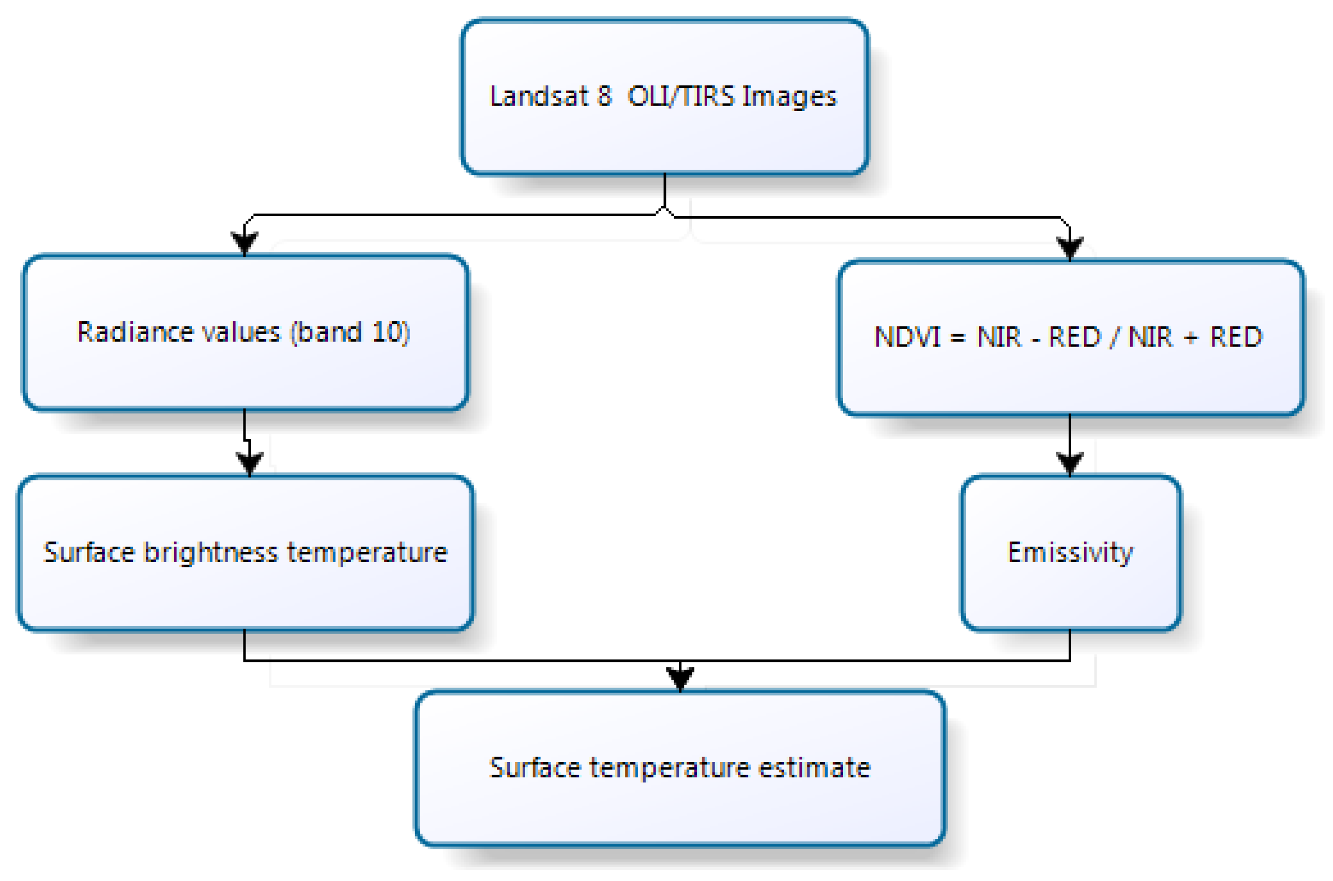
2. Experiments
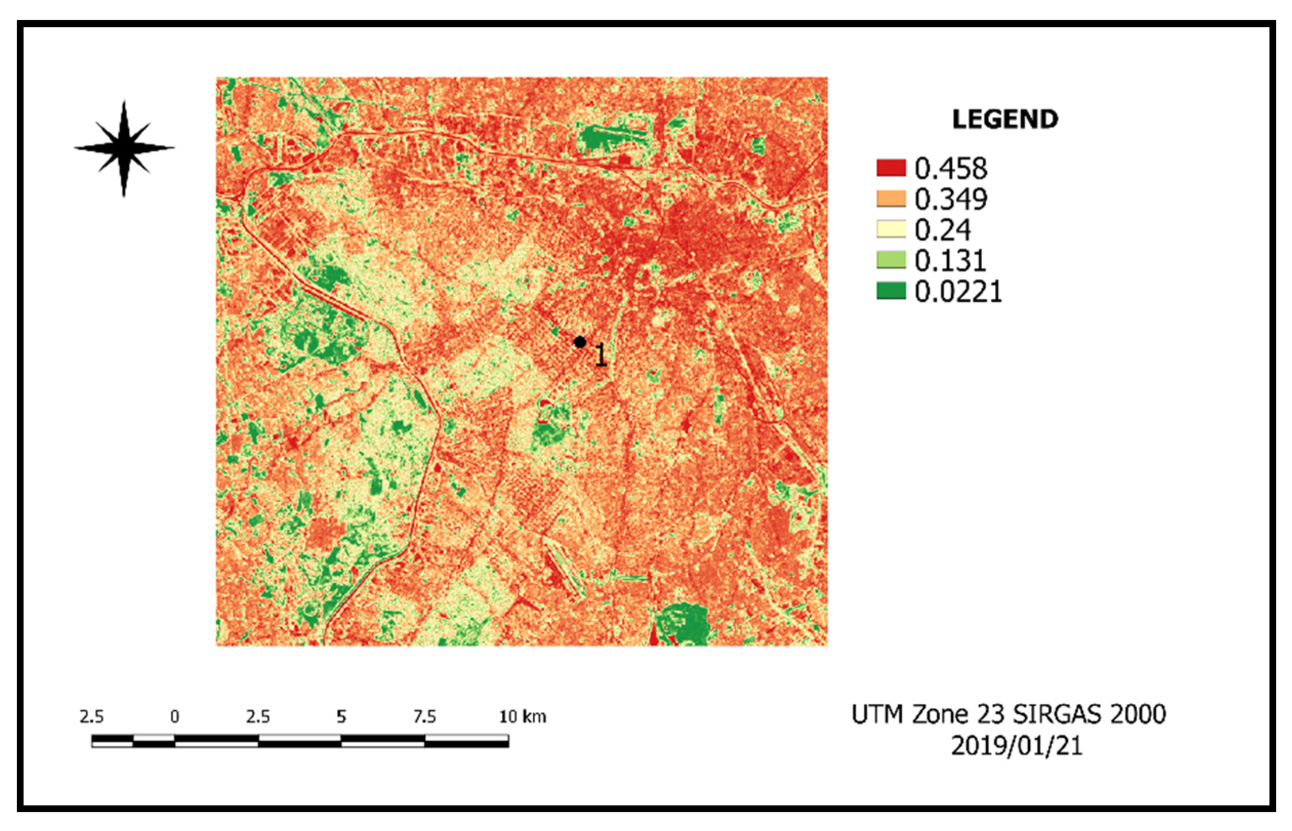
3. Results and Discussion
4. Conclusions
Author Contributions
Institutional Review Board Statement
Informed Consent Statement
Data Availability Statement
Conflicts of Interest
Abbreviations
| ST | Surface Temperature |
| USGS | United States Geological Survey |
| OLI | Operational Land Imager |
| TIRS | Thermal Infra-Red Scanner |
| Qgis | Quantum GIS |
| NDBI | Normalized Difference Built-Up Index |
| NDVI | Normalized Difference Vegetation Index |
References
- PAULO. Rodolfo Fares. Crescimento Urbano Desordenado: O papel do Estado e da Sociedade diante dos impactos socioambientais; Editora Fi: Porto Alegrers, Brazil, 2018; Available online: https://www.univem.edu.br/arquivos/Livro%20Rodolfo%20Fares.pdf (accessed on 15 March 2020).
- Gartland, L. Ilhas de calor: Como mitigar zonas de calor em áreas urbanas; Oficina Textos: São Paulo, Brazil, 2010. [Google Scholar]
- Barros, H.R.; Lombardo, M.A. A ilha de calor urbana e o uso e cobertura do solo em São Paulo SP. Geousp Espaço e Tempo 2016, 20. ISSN 2179-0892. Available online: http://www.revistas.usp.br/geousp/article/view/97783 (accessed on 12 March 2020).
- Germano, P.J.M.M.T. Investigação multitemporal de ilhas de calor e de frescor em Maringá, Paraná, utilizando imagens do satélite landsat 5–2000 a 2010. Master’s Thesis, Universidade Estadual de Maringá, Maringá, Brazil, 2012. Available online: http://www.peu.uem.br/Discertacoes/PauloMonteiro.pdf (accessed on 9 February 2020).
- Oke, T.R. Canyon geometry and the nocturnal urban heat island: Comparison of scale model and field observations. Int. J. Climatol. 1981, 237–254. Available online: https://rmets.onlinelibrary.wiley.com/doi/abs/10.1002/joc.3370010304 (accessed on 16 March 2020). [CrossRef]
- de Fátima Ferreira, L.; Carrilho, S.T.; Mendes, P.C. Áreas Verdes Urbanas: Uma Contribuição Aos Estudos Das Ilhas De Frescor. Braz. Geogr. J. Geosci. Humanit. Res. Medium 2015, 6, 101–120. [Google Scholar]
- Jensen, J.R. Sensoriamento Remoto do Ambiente: Uma Perspectiva em Recursos Terrestres, 2nd ed.; Parêntese: São José dos Campos-SP, Brazil, 2009. [Google Scholar]
- Florenzano, T.G. Imagens de Satélite para Estudos Ambientais, 11th ed.; Pearson Education Brasil Ltd.: São José dos Campos, Brazil, 2013. [Google Scholar]
- IBGE—Instituto Brasileiro de Geografia e Estatística. Censo 2010. Brasília, 2016. Available online: http://ibge.gov.br (accessed on 1 February 2020).
- Kottek, M.; Grieser, J.; Beck, C.; Rudolf, B.; Rubel, F. World Map of the Köppen-Geiger climate classification updated. Meteorol. Z. 2006, 15, 259–263. [Google Scholar] [CrossRef]
- Instituto Nacional de Meteorologia (INMET). 2019. Available online: http://www.inmet.gov.br/portal/index.php?r=tempo/graficos (accessed on 1 February 2020).
- Isaya Ndossi, M.; Avdan, U. Application of Open Source Coding Technologies in the Production of Land Surface Temperature (LST) Maps from Landsat: A PyQGIS Plugin. Remote Sens. 2016, 8, 413. [Google Scholar] [CrossRef]
- Bourscheidt, V. Análise da influência do uso do solo nas variações de temperatura utilizando imagens MODIS e LANDSAT 8. Simpósio Brasileiro de Sensoriamento Remoto (SBSR) 2015, 17, 6750–6756, ISBN 978-85-17-00076-8. Available online: http://www.dsr.inpe.br/sbsr2015/files/p1480.pdf (accessed on 11 October 2019).
- Pereia, C.T.; Lima, R.S.; Bourscheidt, V. Estimativa sazonal da temperatura de superfície e identificação de Ilhas de Calor Urbana na Região Portuária de Santos—SP. In XVIII Simpósio Brasileiro de Sensoriamento Remoto; INPE: Cuiabá-Mato Grosso, Brazil, 2017. [Google Scholar]
- De Oliveira, U.C.; Teixeira, L.F.C.; Soares, F.F.; Mendonça, P.S.; Mendes, J.C.A. Avaliação Do Uso Do Solo e Cobertura Vegetal Na Zona De Amortecimento Do Parque Nacional De Ubajara, Em Ubajara, Ceará. X Congresso Brasileiro de Gestão Ambiental. Fortaleza Ceará, 07 November 2019. Available online: https://www.ibeas.org.br/congresso/Trabalhos2019/XI-095.pdf (accessed on 13 November 2020).
- Sousa, M.T. Análise do NDBI como método para classificar áreas construídas para os anos de 2000 e 2010 nos municípios de São José dos Campos, Jacareí e Arapeí, São Paulo; INPE: Cuiabá-Mato Grosso, Brazil, 2010; pp. 4–7. Available online: http://wiki.dpi.inpe.br/lib/exe/fetch.php?media=cst-310-popea:monografia_monicasousa-trabfinal.pdf (accessed on 18 November 2020).
- Zha, Y.; Gao, J.; Ni, S. Use of normalized difference built-up index in automatically mapping urban areas from TM imagery. Int. J. Remote. Sens. 2003, 24, 583–594. [Google Scholar] [CrossRef]
- De Barros, H.R. A relação entre a ilha de calor, uso e cobertura do solo e o balanço de energia no município de São Paulo: Avaliação do campo térmico nos parques públicos de lazer. Ph.D. Thesis, Curso de Geografia Física, Departamento de Geografia, Universidade de São Paulo-Usp, São Paulo, Brazil, 2016. Available online: https://teses.usp.br/teses/disponiveis/8/8135/tde-27092016151701/publico/2016_HugoRogerioDeBarros_VCorr.pdf (accessed on 16 November 2020).


Publisher’s Note: MDPI stays neutral with regard to jurisdictional claims in published maps and institutional affiliations. |
© 2020 by the authors. Licensee MDPI, Basel, Switzerland. This article is an open access article distributed under the terms and conditions of the Creative Commons Attribution (CC BY) license (https://creativecommons.org/licenses/by/4.0/).
Share and Cite
Ferreira, V.S.; Boschi, L.S.; Souza, G.H.B.d. Identification of Urban Canyons in the City of São Paulo from Landsat 8 Images. Environ. Sci. Proc. 2021, 5, 17. https://doi.org/10.3390/IECG2020-08911
Ferreira VS, Boschi LS, Souza GHBd. Identification of Urban Canyons in the City of São Paulo from Landsat 8 Images. Environmental Sciences Proceedings. 2021; 5(1):17. https://doi.org/10.3390/IECG2020-08911
Chicago/Turabian StyleFerreira, Victor Siqueira, Leticia Sabo Boschi, and Guilherme Henrique Barros de Souza. 2021. "Identification of Urban Canyons in the City of São Paulo from Landsat 8 Images" Environmental Sciences Proceedings 5, no. 1: 17. https://doi.org/10.3390/IECG2020-08911
APA StyleFerreira, V. S., Boschi, L. S., & Souza, G. H. B. d. (2021). Identification of Urban Canyons in the City of São Paulo from Landsat 8 Images. Environmental Sciences Proceedings, 5(1), 17. https://doi.org/10.3390/IECG2020-08911