Next Article in Journal
Improving Up-Close Remote Sensing of Occluded Areas in Vineyards through Customized Multiple-Unmanned-Aerial-Vehicle Path Planning
Previous Article in Journal
Statement of Peer Review
 
 
Please note that, as of 4 December 2024, Environmental Sciences Proceedings has been renamed to Environmental and Earth Sciences Proceedings and is now published here.
Proceeding Paper

Quantification of Coastal Erosion Rates Using Landsat 5, 7, and 8 and Sentinel-2 Satellite Images from 1986–2022—Case Study: Cartagena Bay, Valparaíso, Chile †

by
Idania Briceño de Urbaneja
1,2,*,
Waldo Pérez-Martínez
1,2,
Carolina Martínez
3,4,5,6,
Josep Pardo-Pascual
2,
Jesús Palomar-Vázquez
2,
Catalina Aguirre
7 and
Raimundo Donoso-Garcés
8
1
Hémera Centro de Observación de la Tierra, Facultad de Ciencias, Ingeniería y Tecnología, Universidad Mayor, Camino La Pirámide 5750, Huechuraba 8580745, Chile
2
Geo-Environmental Cartography and Remote Sensing Group, Department of Cartographic Engineering, Geodesy and Photogrammetry, Universitat Politècnica de València, Camí de Vera s/n, 46022 València, Spain
3
Instituto de Geografía, Facultad de Historia, Geografía y Ciencia Política, Pontificia Universidad Católica de Chile, Av. Vicuña Mackenna 4860, Santiago 8320165, Chile
4
Centro de Investigación Para la Gestión Integrada del Riesgo de Desastres (CIGIDEN), Campus San Joaquín-Avda. Vicuña Mackenna 4860, Macul 7820436, Chile
5
Instituto Milenio en Socio-Ecología Costera (SECOS), Av. Libertador Bernardo O’Higgins, 340, Santiago 8331150, Chile
6
Centro UC Observatorio de la Costa Campus, San Joaquín-Avda. Vicuña Mackenna 4860, Macul 7820436, Chile
7
Escuela de Ingeniería Civil y Oceánica, Universidad de Valparaíso, Av. Brasil 1786, Valparaíso 2362844, Chile
8
Escuela Geología, Facultad de Ciencias, Ingeniería y Tecnología, Universidad Mayor, Providencia 7510041, Chile
*
Author to whom correspondence should be addressed.
Presented at the 5th International Electronic Conference on Remote Sensing, 7–21 November 2023; Available online: ecrs2023.sciforum.net/.
Environ. Sci. Proc. 2024, 29(1), 56; https://doi.org/10.3390/ECRS2023-16300
Published: 21 November 2023
(This article belongs to the Proceedings of ECRS 2023)

Abstract

:
Coastal erosion has become one of the many natural hazards affecting Chile’s sandy coastlines. Currently, more than 90% of the sandy coasts of Valparaíso show high erosion rates. Cartagena Bay is one of the coastal areas with the greatest transformations caused by extreme events and anthropogenic activities. Satellite imagery is seen as an invaluable resource for following these coastal changes. This study combines optical satellite imagery, a simulation-derived wave climate, in situ data, the SHOREX system developed in Python, and GIS-based tools such as DSAS to quantify rates of change in the Bay from 1986 to 2022. Satellite-derived shorelines were used to identify erosion hotspot areas in the Bay, differentiating the impact of erosive processes associated with ENSO hydrometeorological phenomena, the 27-F 2010 earthquake, and tidal waves from 2015–2022, which led to major transformations in the morphodynamics of the beach. The results show that the Bay is currently undergoing high erosional processes in 20% of the coastline with values <− 1.5 m/year and 60% with erosion rates ranging from [−0.2 to −1.5 m/year]. Since 2015, these processes have been accentuated, due to increased swells throughout the year.

1. Introduction

Beaches are an essential resource for any coastal country. First, they play an important role in coastal defense [1]. Second, they are of environmental interest since their status as a frontier between the continental and oceanic worlds defines unique and specific habitats in which unique ecosystems develop [2]. Third, they are a social and economic resource because these environments are highly appreciated by society and exploited for tourism use and diverse activities, which, in many cases, is the area’s economic engine [3]. At the same time, these environments are highly dynamic or changing due to increased frequency and intensity of waves, changes in sea level, tsunamis, the effects of climate change, and anthropogenic action [4].
In the last four decades, the central zone of Chile (CZC) has been affected by great-magnitude earthquakes, followed by tsunamis (e.g., Algarrobo 1985 (8.0 Mw); Concepción 2010 (Mw 8.8); Illapel 2015 (Mw 8.4) [5]; ENSO El Niño-Niña (1997–1998; 1998–2000; 2015–2016)); hydro-meteorological events in 2006; 2013; 2015; 2017; and 2018 have frequently affected Chile’s coasts, causing damage to infrastructure, loss of human lives, cessation of port operations, and shipwrecks [6]; the increase in the frequency and intensity of storms surged from 2015 to 2023 [7,8]. Anthropogenic interventions have occurred on wetlands, beaches, and dunes [9]. Coastal erosion is a hazard for cities and infrastructure built near the sea, on wetlands, beaches, and dunes [10].
There is evidence of variations in the coastline in Chile (e.g., [11,12]) that have shown that 80% of the coastline is eroded. Chile’s coasts have been affected by extreme events since 2015, with recurrent storm surges that have increased over previous years between 10% and 25% [13]. This has led to the disruption of the annual dynamic process of the beaches, accentuated by the anthropic interventions on these coastal environments, wetlands, and dunes that promote their degradation. These types of measurements have contributed to knowing the dynamics of the beaches. They also require complementary techniques that allow them to cover large extensions of territory and analyze areas with difficult access. Shoreline monitoring at the country level is complex since planning policies are coordinated at regional and local levels, especially in a country with such a long coastline as Chile [14]. Currently, in Chile, coastal erosion has been studied with conventional techniques of high precision, combining in situ data collection and historical aerial photographs to study the evolution of the coastline during extreme meteorological events [6,12].
The analysis of coastal dynamics has become internationally crucial in recent years due to evidence of rising sea levels and increased storm surge intensity [15]. In this context, remote sensing has become a robust, stable, and comparable tool for monitoring coasts and their erosive state, multidecadal variability, dynamic coastline, and landslide hazard analysis [16,17]. In addition to a news dataset documenting four decades of coastal change [18], it has also allowed for the development of algorithms for the massive extraction of shorelines [19,20,21].
This study aims to quantify coastal erosion in one of the most anthropized bays of the Valparaíso Region, Chile, from satellite images Landsat 5, 7, and 8 and Sentinel-2 to know the erosive state of the bay.

2. Materials and Methods

2.1. Study Area

Cartagena Bay is in the Province of San Antonio, has a length of approximately 6 km associated with an ancient dune field, and is bounded by two rocky promontories. The mouth of the Cartagena River forms a coastal wetland, currently heavily intervened by different urban uses. Moreover, one of the largest conurbations of the Valparaíso region is in this area (Figure 1).

2.2. Automatic Extraction of Shorelines and Model

The SHOREX system of [20] was used to mass extract satellite-derived shorelines (SDS) from imagery (Landsat 5, 7, 8, and Sentinel-2). SWIR1 bands of 1.55–1.75 μm, 1.57–1.65 μm, and 1.56–1.65 μm from Landsat 5 and 7, Landsat 8 OLI, and Sentinel-2, respectively, were corrected to the top of the atmosphere (TOA), from the summer of 1986 to the winter of 2022. From the beach width data derived, a model of spatio-temporal changes in the bay was constructed. Cross-sectional profiles for every 100 m were used to identify changes and their drivers, and data with noise from shadows and segmented shorelines were removed. A TIN interpolation was performed and subsequently rasterized to identify when and where the morphodynamic beach changes are occurring [21].

2.3. Climate Waves

In Chile, there are no long-term wave records; therefore, numerical simulations have been carried out using the Wavewatch III spectral model developed by NOAA/NCEP, the Technical University of Delft, and NASA. This simulation was carried out for the entire Pacific basin, with a resolution of one degree.

2.4. Erosion Rates

Bay erosion and accretion rates were calculated using the Digital Shoreline Analysis System (DSAS) [22,23]. Linear regression (LRR) was used to calculate the rate of shoreline change. Erosion rates were categorized according to the [24] criteria as follows (Table 1).

3. Results and Discussion

3.1. Automatic Extraction of Shorelines

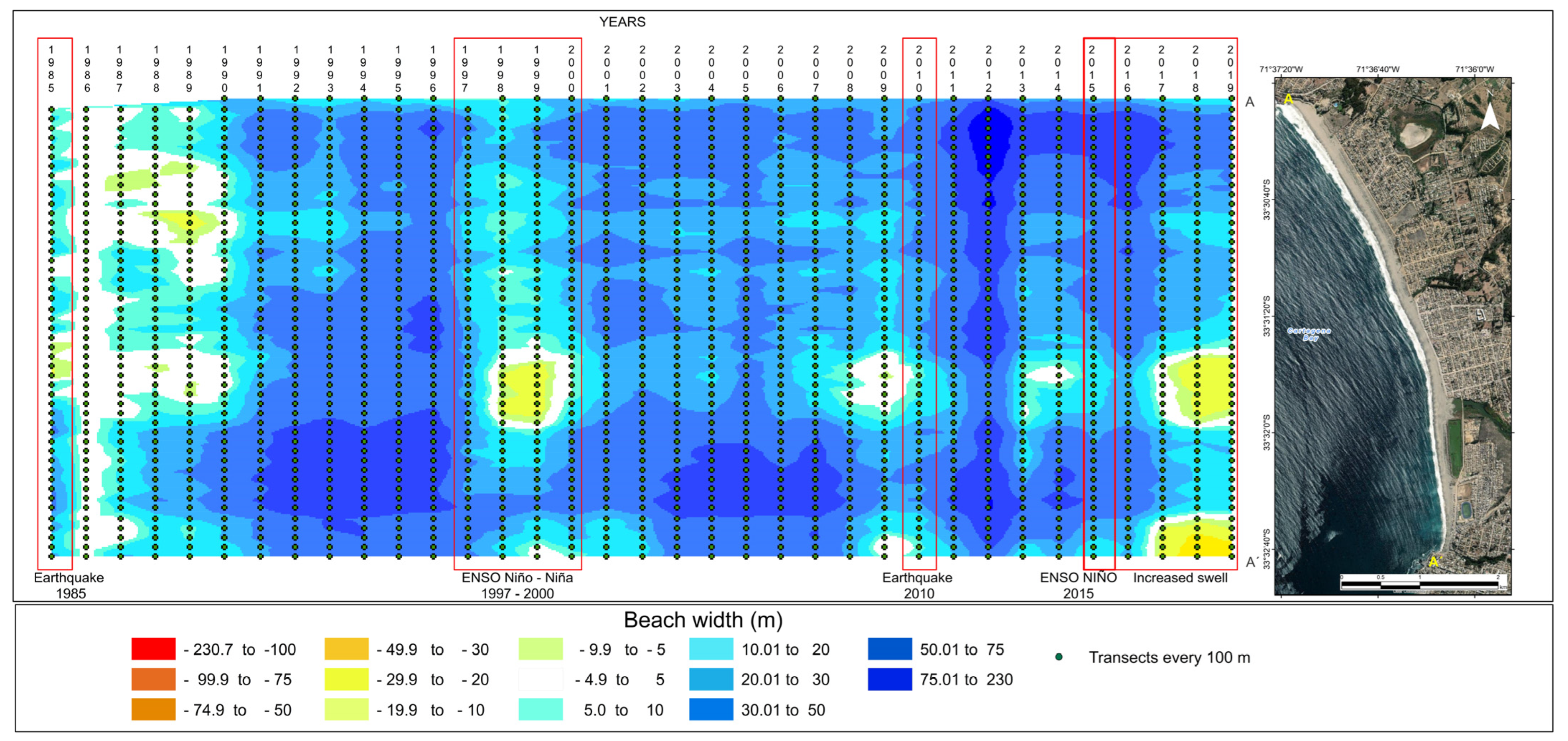
A total of 680 positions on the shoreline were obtained from 1986–2022. The average width (m) of Cartagena Bay is 102.1 m. The maximum value was recorded in October 2007, and the minimum value was recorded in the summer of 2016 with 214 and 11 m, respectively. Figure 2 shows marked differences in the width of the beach due to earthquakes, strong waves, and the persistence of intense and recurrent waves since 2015, as well as their recovery after extreme events. The beach widths show the tectonic influence conditioning the relative position of the coastline. The model of beach width changes shows how the extreme events of earthquakes, tsunamis (1985 and 2010), ENSO, and hydrometeorological events had a significant impact on the Bay of Cartagena, generating a condition of extreme erosion in the bay. This situation can be seen in the structural inlet system of Pichilemu, which has been strongly affected by the earthquake and tsunami [25].

3.2. Climate Waves

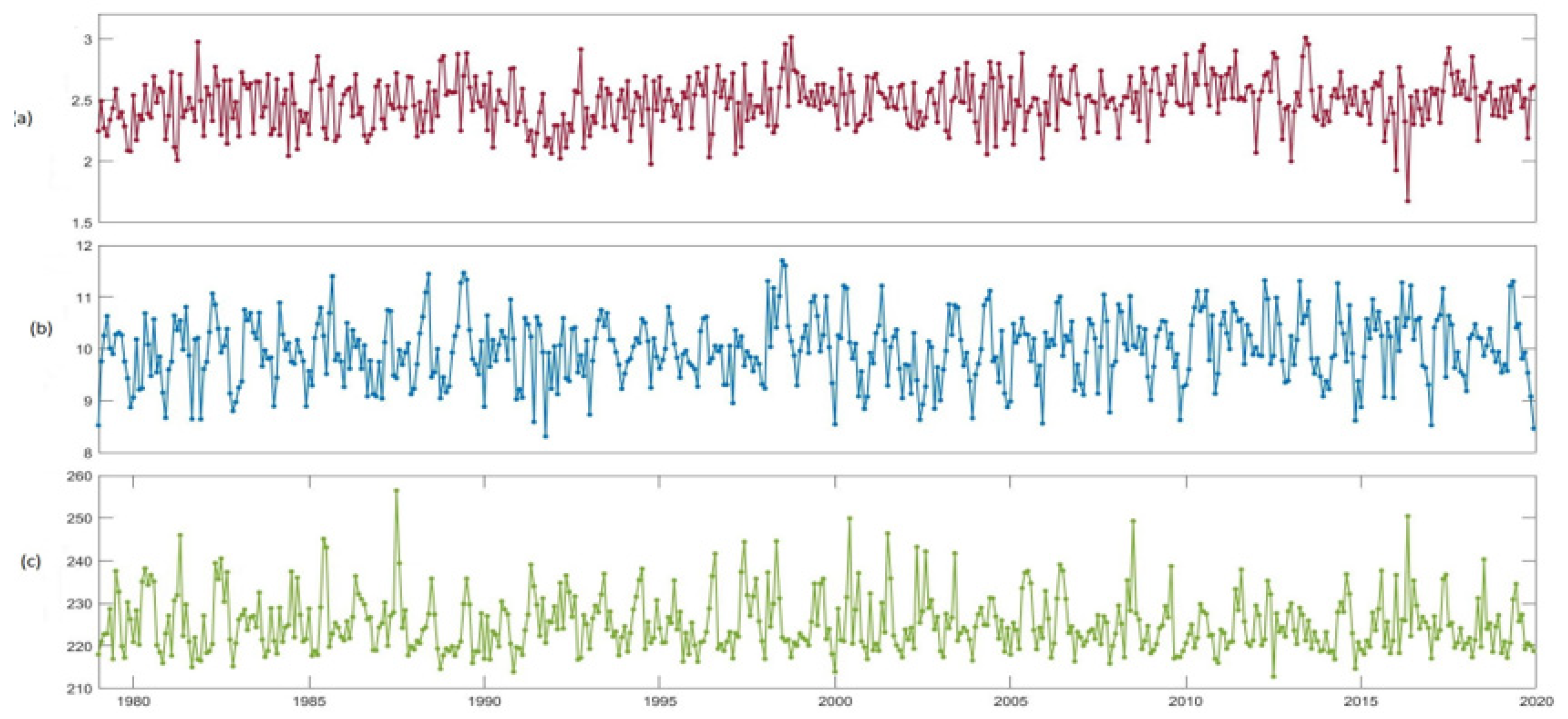
The wave climatology in Chile is controlled by seasonal changes in the intensity and trajectories of storms associated with extratropical cyclones, both in the Northern and Southern Hemispheres. Since our country is closer to the wave generation zone of the Southern Hemisphere, its dominant propagation direction is from the W in the south and the SW in the central and northern zones. In addition, the spatial pattern of significant height is influenced by the meridional variation in the surface wind speed, where the stronger winds over the Southern Ocean play a fundamental role in generating higher waves at higher latitudes. Valparaíso region shows low seasonal variability in average wave parameters (Figure 3). The significant height is around 2.5 m and presents an average seasonal change of 10 cm (Figure 3a). Something similar occurs with the periods, which are in the order of 10 s, and have an average seasonal variation of 1 s (Figure 3b). The climatology of the wave direction shows the dominance of waves propagating from the SW (225°), which has an average variation of 10° (Figure 3c).

3.3. Erosion Rates

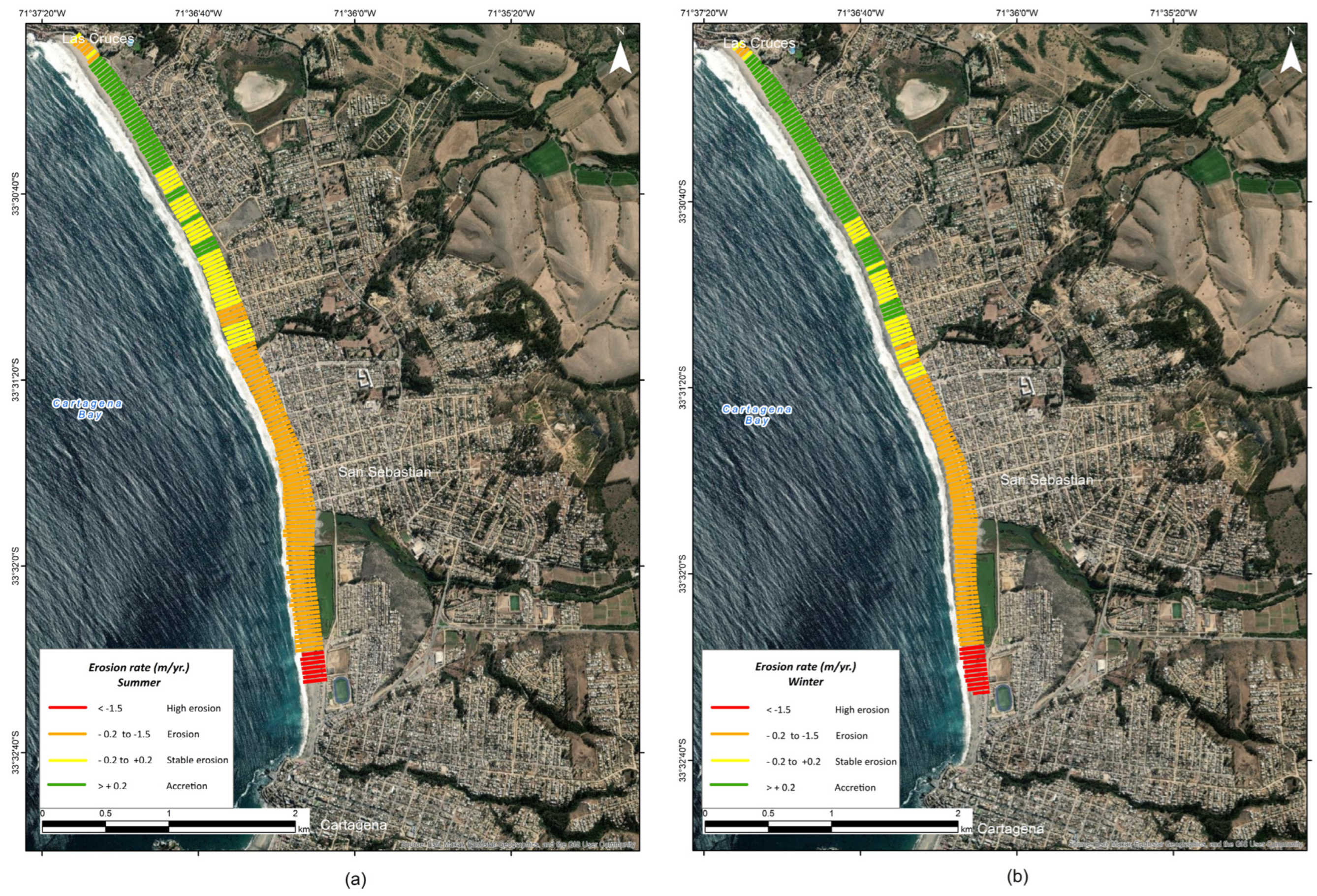
Coastal erosion has become a new hazard affecting coastal areas. Studies have shown that 86% of these zones present an erosive state, with values ranging between −0.2 and −1.5 m/year, categorized as high erosion and erosion. Figure 4 summarizes the erosive state of the Bay of Cartagena in the period studied, showing a significant increase in erosion in the summer with an erosion rate of 60% and from −0.2 to −1.5 m/year, which has been aggravated by the increased recurrence of intense and persistent storm surges in this season since 2015 [12]. Cartagena Bay, on average, experiences coastal retreat measuring 0.7 m/yr. These causes are explained by the relationship between storm surge and erosion, which has been clarified through recent studies [26]. Among other causes in these coasts is the role of the seismic cycle in regulating the coast, ENSO phenomena, ocean–atmosphere interactions, and anthropogenic activity, among others, which are much less known, and it is a priority to advance knowledge of them. In this context, it is relevant to highlight the relationship between processes, given the complexity of coastal erosion as a phenomenon, but also in the methods currently in use, which facilitate the reaching of better interpretations in terms of spatial and temporal scales.

Author Contributions

Conceptualization, I.B.d.U., J.P.-P. and J.P.-V.; methodology, I.B.d.U., J.P.-P. and J.P.-V.; software, J.P.-V.; validation, I.B.d.U., J.P.-P., J.P.-V., C.M. and C.A.; formal analysis, I.B.d.U., C.M., J.P.-P., J.P.-V. and C.A.; Writing—original draft preparation, I.B.d.U.; writing—review and editing, J.P.-P., W.P.-M., J.P.-V., C.M. and C.A.; Visualization, C.A. and R.D.-G. Supervision, C.M., J.P.-P. and J.P.-V.; Funding: W.P.-M. All authors have read and agreed to the published version of the manuscript.

Funding

Agencia Nacional de Investigación y Desarrollo (FONDEF IDeA I+D 2019, Proyecto ID19I10361. MONCOSTA Monitoreo satelital de la dinámica y evolución de la costa chilena); CGAT-UPV researchers are supported by MONOBESAT (PID2019−111435RB-I00) by the Spanish Ministry of Science, Innovation and Universities.

Institutional Review Board Statement

Not applicable.

Informed Consent Statement

Not applicable.

Data Availability Statement

Data from supporting studies from Moncosta-Coastal Monitoring are available online.

Conflicts of Interest

The authors declare no conflicts of interest.

References

  1. Powell, E.J.; Tyrrell, M.C.; Milliken, A.; Tirpak, J.M.; Staudinger, M.D. A review of coastal management approaches to support the integration of ecological and human community planning for climate change. J. Coast. Conserv. 2018, 23, 1–18. [Google Scholar] [CrossRef]
  2. McLachlan, A.; Brown, A.C. Interstitial Ecology. In The Ecology of Sandy Shores; Elsevier: Amsterdam, The Netherlands, 2006. [Google Scholar] [CrossRef]
  3. Kozyrakis, G.; Delis, A.; Alexandrakis, G.; Kampanis, N. Numerical modeling of sediment transport applied to coastal morphodynamics. Appl. Numer. Math. 2016, 104, 30–46. [Google Scholar] [CrossRef]
  4. Feagin, R.A.; Sherman, D.J.; Grant, W.E. Coastal erosion, global sea-level rise, and the loss of sand dune plant habitats. Front. Ecol. Environ. 2005, 3, 359–364. [Google Scholar] [CrossRef]
  5. Ruiz, S.; Madariaga, R. Historical and recent large megathrust earthquakes in Chile. Tectonophysics 2018, 733, 37–56. [Google Scholar] [CrossRef]
  6. Caba, R.C.; Beyá Marshall, J.; Mena, P.M. Cuantificación de los Daños Históricos a Infraestructura Costera Por Marejadas en Las Costas de Chile. In XXII Congreso Chileno de Ingeniería Hidráulica; Universidad de Valparaíso: Valparaíso, Chile, 2015; p. 14. Available online: https://oleaje.uv.cl/descargables/Publicacionescongresos/2015-CuantificacióndelosdañoshistóricospormarejadasenlascostasdeChile-Camposetal.pdf (accessed on 15 September 2023).
  7. Santoso, A.; Mcphaden, M.J.; Cai, W. The Defining Characteristics of ENSO Extremes and the Strong 2015/2016 El Niño. Rev. Geophys. 2017, 55, 1079–1129. [Google Scholar] [CrossRef]
  8. Wu, W.; Leonard, M. Impact of ENSO on dependence between extreme rainfall and storm surge. Environ. Res. Lett. 2019, 14, 124043. [Google Scholar] [CrossRef]
  9. Martínez, C.; López, P.; Rojas, C.; Qüense, J.; Hidalgo, R.; Arenas, F. A sustainability index for anthropized and urbanized coasts: The case of Concón Bay, central Chile. Appl. Geogr. 2020, 116, 102166. [Google Scholar] [CrossRef]
  10. Le Cozannet, G.; Bulteau, T.; Castelle, B.; Ranasinghe, R.; Wöppelmann, G.; Rohmer, J.; Bernon, N.; Idier, D.; Louisor, J.; Salas-Y-Mélia, D. Quantifying uncertainties of sandy shoreline change projections as sea level rises. Sci. Rep. 2019, 9, 42. [Google Scholar] [CrossRef] [PubMed]
  11. Ministerio del Medio Ambiente. Plan de Acción Nacional de Cambio Climático 2017–2022; MMA: Santiago, Chile, 2017. [Google Scholar]
  12. Martínez, C.; Briceño-de-Urbaneja, I. 3.3. La erosión costera en Chile: Problemas actuales y desafíos futuros. In Hacia Una Ley de Costas en Chile: Bases Para Una Gestión Integrada de Áreas Costeras; CIGIDEN: Valparaíso, Chile, 2022; Available online: https://www.cigiden.cl/geolibro-hacia-una-ley-de-costas-en-chile-bases-para-una-gestion-integradade-areas-costeras/ (accessed on 25 September 2023).
  13. Briceño-de-Urbaneja, I.; Sánchez-García, E.; Pardo-Pascual, J.E.; Palomar-Vázquez, J.; Ugalde-Peralta, R.; Aguirre-Galaz, C.; Pérez-Martínez, W.; Vidal-Páez, P. Cambios Espaciotemporales Costeros Con Imágenes Landsat 8 Y Sentinel 2 (2015–2019) En Chile Central; Playa Reñaca, Bahía De Concón Y Bahía De Algarrobo. In III Congress in Geomatics Engineering—CIGEO 2021, 7–8 July Valencia, Spain; Editorial Universitat Politècnica de València: Valencia, Spain, 2021; pp. 302–310. [Google Scholar] [CrossRef]
  14. Martínez, S.; Salinas, C. Morfodinámica y evolución reciente de playa Tunquén, Chile central Introducción Material y métodos. Rev. De Biol. Mar. Y Oceanogr. 2009, 44, 203–215. [Google Scholar] [CrossRef]
  15. Harley, C.D.G.; Hughes, A.R.; Hultgren, K.M.; Miner, B.G.; Sorte, C.J.B.; Thornber, C.S.; Rodriguez, L.F.; Tomanek, L.; Williams, S.L. The impacts of climate change in coastal marine systems. Ecol. Lett. 2006, 9, 228–241. [Google Scholar] [CrossRef] [PubMed]
  16. Cabezas-Rabadán, C.; Pardo-Pascual, J.E.; Palomar-Vázquez, J. Characterizing the Relationship between the Sediment Grain Size and the Shoreline Variability Defined from Sentinel-2 Derived Shorelines. Remote. Sens. 2021, 13, 2829. [Google Scholar] [CrossRef]
  17. Bishop-Taylor, R.; Nanson, R.; Sagar, S.; Lymburner, L. Mapping Australia's dynamic coastline at mean sea level using three decades of Landsat imagery. Remote. Sens. Environ. 2021, 267, 112734. [Google Scholar] [CrossRef]
  18. Harley, M.D.; Kinsela, M.A.; Sánchez-García, E.; Vos, K. Shoreline change mapping using crowd-sourced smartphone images. Coast. Eng. 2019, 150, 175–189. [Google Scholar] [CrossRef]
  19. Vos, K.; Splinter, K.D.; Harley, M.D.; Simmons, J.A.; Turner, I.L. CoastSat: A Google Earth Engine-enabled Python toolkit to extract shorelines from publicly available satellite imagery. Environ. Model. Softw. 2019, 122, 104528. [Google Scholar] [CrossRef]
  20. Palomar-Vázquez, J.; Almonacid-Caballer, J.; Pardo-Pascual, J.E.; Sanchez-García, E. SHOREX: A new tool for automatic and massive extraction of shorelines from Landsat and Sentinel 2 imagery. In Proceedings of the 7th International Conference on the Application of Physical Modelling in Coastal and Port Engineering and Science (Coastlab), Santander, Spain, 22–26 May 2018. [Google Scholar]
  21. Cabezas-Rabadán, C.; Pardo-Pascual, J.E.; Palomar-Vázquez, J.; Fernández-Sarría, A. Characterizing beach changes using high-frequency Sentinel-2 derived shorelines on the Valencian coast (Spanish Mediterranean). Sci. Total Environ. 2019, 691, 216–231. [Google Scholar] [CrossRef]
  22. Thieler, E.R.; Himmelstoss, E.A.; Zichichi, J.L.; Miller, T.L. The Digital Shoreline Analysis System (DSAS) Version 3.0, an ArcGIS Extension for Calculating Historic Shoreline Cange; US Geological Survey: Reston, VA, USA, 2005.
  23. Himmelstoss, E.A.; Henderson, R.E.; Kratzmann, M.G.; Farris, A.S. Digital Shoreline Analysis System (DSAS) Version 5.1 User Guide; US Geological Survey: Reston, VA, USA, 2021. [CrossRef]
  24. Rangel-Buitrago, N.G.; Anfuso, G.; Williams, A.T. Coastal erosion along the Caribbean coast of Colombia: Magnitudes, causes and management. Ocean Coast. Manag. 2015, 114, 129–144. [Google Scholar] [CrossRef]
  25. Soto, M.-V.; Arriagada, J.; Castro-Correa, C.P.; Ibarra, I.; Giuliano, R. Condiciones geodinámicas derivadas del terremoto y tsunami de 2010 en la costa de Chile central. El caso de Pichilemu. Rev. De Geogr. Norte Gd. 2015, 60, 79–95. [Google Scholar] [CrossRef]
  26. Ministerio del Medio Ambiente. Volumen 2: Exposición, en “Determinación del Riesgo de los Impactos del Cambio Climático en las Costas de Chile”, Documento Preparado Por: Winckler, P.; Contreras-López, M.; Vicuña, S.; Larraguibel, C.; Mora, J.; Esparza, C.; Salcedo, J.; Gelcich, S.; Fariña, J. M.; Martínez, C.; Agredano, R.; Melo, O.; Bambach, N.; Morales, D., Marinkovic, C.; Pica, A., Santiago, Chile. 2019. Available online: https://cambioclimatico.mma.gob.cl/wp-content/uploads/2020/04/2019-10-22-Informe-V02-CCCostas-Exposicio%CC%81n-Rev1.pdf (accessed on 30 September 2023).
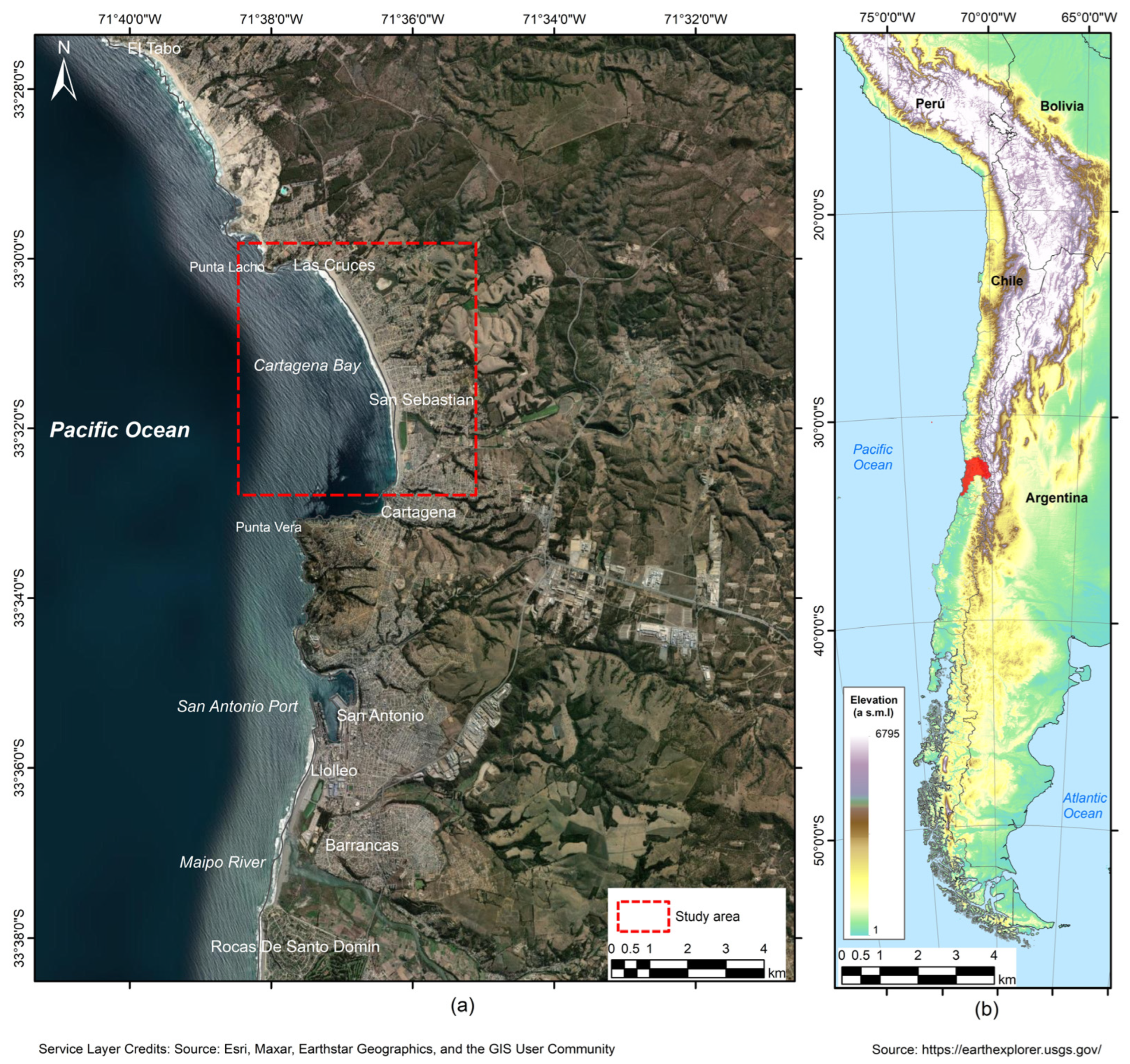
Figure 1. The red rectangle is the study area; (a) Cartagena Bay location; (b) international location.
Environsciproc 29 00056 g001
Figure 2. Spatiotemporal model. The green point transects each 100 m. The red rectangles are indicators of the extreme events that have affected the study area and show the recovery cycles of the beach before and after the events.
Environsciproc 29 00056 g002
Figure 3. Monthly average climatology of swell parameters off the coast of Valparaíso:(a) Significant wave height, Hs [m]—red line; (b) Period (seg)—blue line; and (c) Direction (°)—green line.
Environsciproc 29 00056 g003
Figure 4. Erosion rates in Cartagena Bay: (a) erosion rate in summer; (b) erosion rate in winter.
Environsciproc 29 00056 g004
Table 1. Erosion rate categories.
Rates of Change
(m/yr.)
Categories
<−1.5High erosion
−0.2 y −1.5Erosion
−0.2 y +0.2Stable erosion
>+0.2Accretion
Disclaimer/Publisher’s Note: The statements, opinions and data contained in all publications are solely those of the individual author(s) and contributor(s) and not of MDPI and/or the editor(s). MDPI and/or the editor(s) disclaim responsibility for any injury to people or property resulting from any ideas, methods, instructions or products referred to in the content.