Next Article in Journal
A Methodological Approach to Identify Thermal Anomaly Hotspots Misclassified as Fire Pixels in Fire Radiative Power (FRP) Products
Previous Article in Journal
Efficient Assessment of Crop Spatial Variability Using UAV Imagery: A Geostatistical Approach
 
 
Please note that, as of 4 December 2024, Environmental Sciences Proceedings has been renamed to Environmental and Earth Sciences Proceedings and is now published here.
Proceeding Paper

Urban Effects on Cloud Base Height and Cloud Persistence over Sofia, Bulgaria †

by
Ventsislav Danchovski
* and
Danko Ivanov
Department of Meteorology and Geophysics, Faculty of Physics, Sofia University, 1164 Sofia, Bulgaria
*
Author to whom correspondence should be addressed.
Presented at the 5th International Electronic Conference on Remote Sensing, 7–21 November 2023; Available online: https://ecrs2023.sciforum.net/.
Environ. Sci. Proc. 2024, 29(1), 45; https://doi.org/10.3390/ECRS2023-16317
Published: 28 November 2023
(This article belongs to the Proceedings of ECRS 2023)

Abstract

:
Cities may have local weather and climates that are significantly different from their surrounding rural areas due to the different physical characteristics of urban surfaces and emissions of substances, with the latter being modulated by the rhythm of the urban ecosystem. Radiative, thermal, moisture and aerodynamic properties of the urban surface influence cloud formation as well as their characteristics. By using in situ measurements as well as data from remote sensing instruments (ceilometers) located in the city center and its outskirts, urban impact on cloudiness over the city of Sofia is evaluated. It is found that the cloud base height over the city center reaches more than 200 m higher than that over the rural area. It is shown that clouds over the rural area are more persistent in cold months as well as in the afternoon in spring.

1. Introduction

Clouds are an important parameter of Earth’s climate as they determine surface net radiation by the modification of incoming and outgoing radiation. Clouds are also part of the water cycle, so they are involved in water and energy transport. Clouds hanging over cities control shortwave energy that can be harnessed by solar panels and exploited by the population, and so clouds directly influence human life. Although cloud formation is the result of natural processes, there are reports about urban effects on clouds and precipitation [1]. Cloud base height (CBH) is found to be higher over cities [2]; changes in cloud cover have been identified as well [3]. The observed urban impact on clouds and precipitation is hypothesized to be due to increased turbulent mixing and thermally driven convection [4] because of urban heat islands. Another possible cause is forced updraft due to the surface convergence that is observed over urban areas with increased roughness [5]. Some of the emitted pollutants in urban atmospheres may act as cloud condensation nuclei which affect cloud formation and precipitation [6]. Confirming the sought-after urban effects on cloudiness is hindered by the constantly moving atmosphere, which may lead to cloud detection that is far away from the cloud’s origin. Often, cities are located around the borders of natural landscapes with contrasting physical properties (e.g., sea–land, mountain–valley); this leads to natural inhomogeneities in cloudiness that overlap with urban ones [7].
Detecting urban influence requires precise quantification of the cloud characteristics of interest, making human cloud observations with questionable usefulness. Near surface measurements of air humidity and temperature can be used to estimate the lifting condensation level (LCL) that serves as a proxy for cloud base height [8], although its applicability is limited to convective clouds. Reference instruments for cloud base height measurement are the ceilometers [9] that are routinely used to ensure cloud base information for air traffic safety at many airports. Ceilometers are low-power lidars that determine CBH by emitting laser pulses and measurements of their two-way (to the cloud and back) flight time. Nowadays, ceilometers’ popularity is growing due to the diverse applications developed within some pan-European initiatives [10,11].
The main goal of this work is to test whether the cloudiness over Sofia is influenced by the urban surface. A better understanding of the seasonal and daily variations in urban influence is also among the goals of this work.

2. Materials and Methods

A combination of in situ and remote measurements of air and cloud parameters over a 10-year period (2011–2020) for two locations were used in this study. The first location, Sofia Airport (hereafter LBSF, it is located northeast of the city, 42.696° N; 23.417° E, Figure 1), is equipped with instruments providing important parameters for aviation safety. The airport’s automatic system records meteorological data every 30 min in the METAR reports. Air temperature and humidity (used in LCL estimation) as well as cloud base height (derived by the Vaisala CL31 ceilometer) are the chosen parameters that are analyzed in this study. The second location is a large park in the city center (hereafter SU, it has coordinates 42.682° N; 23.345° E, Figure 1), where an automatic weather station (AWS) and the ceilometer Lufft CHM15k are situated. Data from the instruments are logged every 10 and 1 min, respectively. As atmospheric boundary layer height over Sofia in summer is on average approximately 2500 m [12], all higher clouds were filtered out since they are quite unlikely to be associated with urban area influence.

3. Results and Discussion

To determine whether urban areas affect cloudiness, we focus on two macrophysical cloud characteristics—cloud base height and cloud persistence. The first can be approximately evaluated by LCL or routinely measured by ceilometers; the second is the ratio of the time when a ceilometer detects a cloud to the total measurement duration. To verify whether the urban influence on the cloud parameters exhibits diurnal and annual cycles, we present the mean values for each hour and month on heatmap plots.
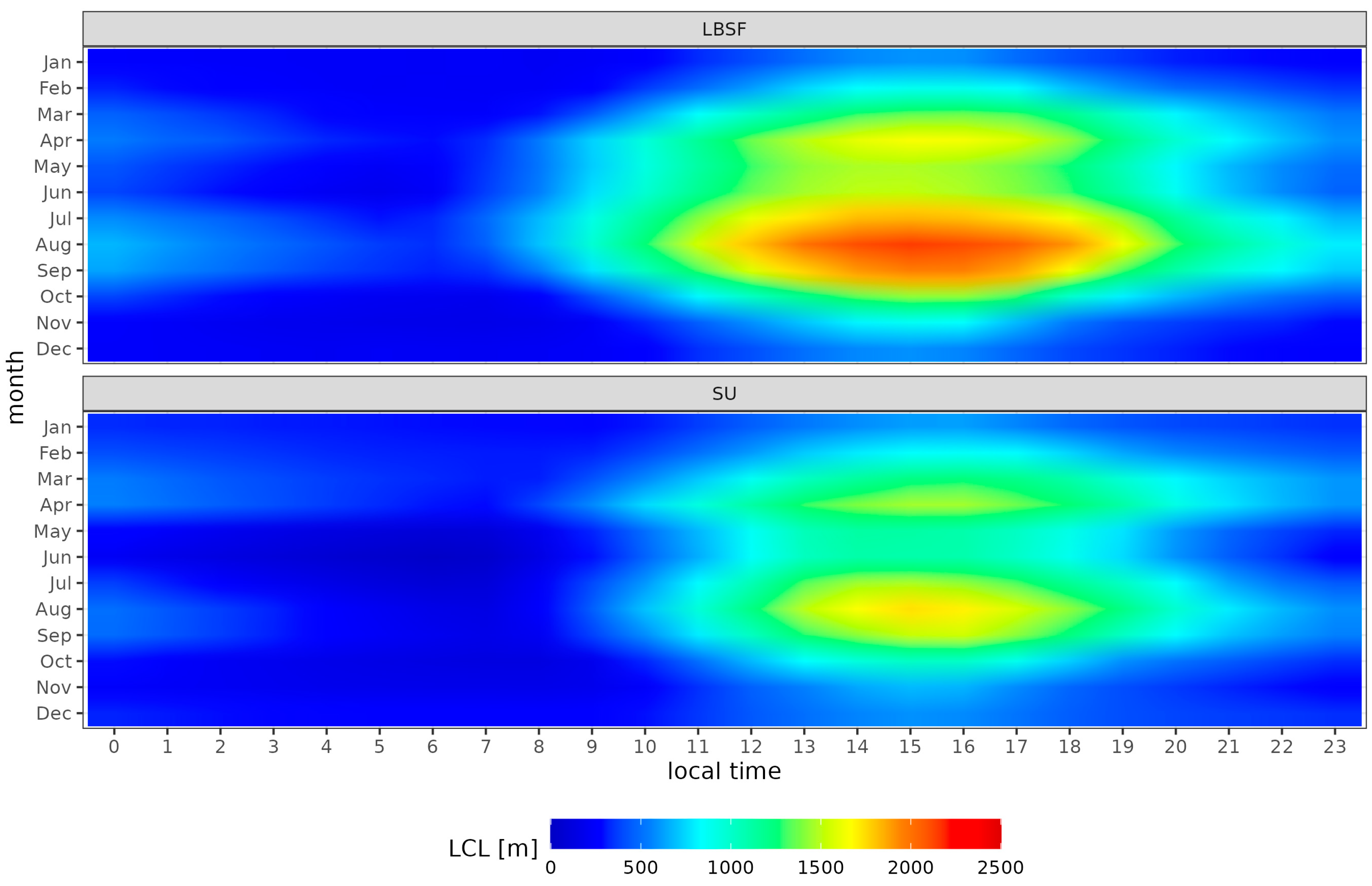
LCL heatmaps (Figure 2) reveal two maxima in the afternoons (15LT) of April and August. The absolute maximum is approximately 2150 m and 1740 m at the LBSF (airport) and SU (city center). While surprising at first, it looks reasonable if the local climate of AWS is considered. Though being in the city center, the SU station is in a park, where air humidity is expected to be higher, and so LCL is lower. In contrast, despite being situated outside of the city, LBSF AWS is likely to be exposed to the local effects of large areas covered by asphalt and concrete, resulting in lower humidity (due to reduced evaporation) that leads to higher LCL. The local minimum in May for both stations is related to more rainy weather.
A heatmap plot of the CBH (retrieved by the ceilometers) over each location (Figure 3) reveals similar bimodal distribution. Again, the two maxima are in April and August but are delayed by approximately two hours. However, the larger values are registered over the city center (maximum 1880 m), not over the airport (maximum 1600 m), in contrast to what is found for LCL. The duration of the relatively high CBHs (if compared against LCLs) is longer for both stations, so that CBHs > 1500 m are measured even at night and in the early morning in summer months. That may be related to intensive turbulent fluxes and updraft over the city accompanying the heat island.
Regarding the percentage of time, a ceilometer detected low clouds (CBH < 2500 m), i.e., cloud persistence; they were found to be greater over the airport and less over the city (Figure 4). This is most likely a consequence of higher temperatures and lower air humidity in the boundary layer over the city compared to that over the rural area. Also, for both stations, as one can expect, the winter months are characterized by more frequent low clouds. The seasonal variation in the diurnal cycle of cloud persistence is also worth noting. The afternoon persistence is higher in the summer as well as in the morning hours of the winter months. The first can be explained by the development of convective fair-weather clouds, the second by the presence of low clouds and even fog, which are more typical for the airport (LBSF station) than the city center (SU station).

4. Conclusions

Urban areas were confirmed to affect cloud formation and some cloud parameters. It was shown that LCL-based estimates of CBH should be used with caution due to the lack of representativeness of the measurement site. Over Sofia, CBH showed a bimodal distribution with maximum values in the afternoon hours in April and August. The highest CBH above the center is more than 200 m higher than that outside the city. Cloud persistence showed seasonal changes in the diurnal cycle. Winter morning and summer afternoon maxima were recorded over both stations. It turned out that over the city the clouds are less persistent than outside the city, contrary to previous studies carried out over megacities [3].

Author Contributions

Conceptualization, methodology, visualization, software, writing, project administration, and funding acquisition, V.D.; formal analysis and investigation, V.D. and D.I.; data curation, D.I. All authors have read and agreed to the published version of the manuscript.

Funding

This research was funded by the Bulgarian National Science Fund, grant number KP-06-COST/7, from 19 August 2021.

Institutional Review Board Statement

Not applicable.

Informed Consent Statement

Not applicable.

Data Availability Statement

METAR data are freely available at https://mesonet.agron.iastate.edu/ (accessed on 20 January 2023). Data from SU station are possibly available on request.

Acknowledgments

Acknowledgments are due to all members of COST action CA18235–“PROfiling the atmospheric Boundary layer at European scale” (PROBE) for the helpful discussions and exchange of knowledge and ideas. The authors are also grateful to the Iowa Environmental Mesonet of Iowa State University for archiving the METER data. The authors are also thankful to all contributors to the R project. The anonymous reviewers deserve acknowledgement for their comments, which contributed to improving the manuscript quality.

Conflicts of Interest

The authors declare no conflicts of interest. The funders had no role in the design of the study; in the collection, analyses or interpretation of data; in the writing of the manuscript; or in the decision to publish the results.

References

  1. Liu, J.; Niyogi, D. Meta-Analysis of Urbanization Impact on Rainfall Modification. Sci. Rep. 2019, 9, 7301. [Google Scholar] [CrossRef] [PubMed]
  2. Angevine, W.M.; White, A.B.; Senff, C.J.; Trainer, M.; Banta, R.M.; Ayoub, M.A. Urban–Rural Contrasts in Mixing Height and Cloudiness over Nashville in 1999. J. Geophys. Res. Atmos. 2003, 108, 4092. [Google Scholar] [CrossRef]
  3. Theeuwes, N.E.; Barlow, J.F.; Teuling, A.J.; Grimmond, C.S.B.; Kotthaus, S. Persistent Cloud Cover over Mega-Cities Linked to Surface Heat Release. npj Clim. Atmos. Sci. 2019, 2, 15. [Google Scholar] [CrossRef]
  4. Varentsov, M.; Wouters, H.; Platonov, V.; Konstantinov, P. Megacity-Induced Mesoclimatic Effects in the Lower Atmosphere: A Modeling Study for Multiple Summers over Moscow, Russia. Atmosphere 2018, 9, 50. [Google Scholar] [CrossRef]
  5. Rozoff, C.M.; Cotton, W.R.; Adegoke, J.O. Simulation of St. Louis, Missouri, Land Use Impacts on Thunderstorms. J. Appl. Meteorol. Climatol. 2003, 42, 716–738. [Google Scholar] [CrossRef]
  6. Schmid, P.E.; Niyogi, D. Modeling Urban Precipitation Modification by Spatially Heterogeneous Aerosols. J. Appl. Meteorol. Climatol. 2017, 56, 2141–2153. [Google Scholar] [CrossRef]
  7. Theeuwes, N.E.; Boutle, I.A.; Clark, P.A.; Grimmond, S. Understanding London’s Summertime Cloud Cover. Q. J. R. Meteorol. Soc. 2022, 148, 454–465. [Google Scholar] [CrossRef]
  8. Lawrence, M.G. The Relationship between Relative Humidity and the Dewpoint Temperature in Moist Air: A Simple Conversion and Applications. Bull. Am. Meteorol. Soc. 2005, 86, 225–234. [Google Scholar] [CrossRef]
  9. An, N.; Pinker, R.T.; Wang, K.; Rogers, E.; Zuo, Z. Evaluation of Cloud Base Height in the North American Regional Reanalysis Using Ceilometer Observations. Int. J. Climatol. 2020, 40, 3161–3178. [Google Scholar] [CrossRef]
  10. Illingworth, A.J.; Cimini, D.; Haefele, A.; Haeffelin, M.; Hervo, M.; Kotthaus, S.; Löhnert, U.; Martinet, P.; Mattis, I.; O’Connor, E.J.; et al. How Can Existing Ground-Based Profiling Instruments Improve European Weather Forecasts? Bull. Am. Meteorol. Soc. 2019, 100, 605–619. [Google Scholar] [CrossRef]
  11. Cimini, D.; Haeffelin, M.; Kotthaus, S.; Löhnert, U.; Martinet, P.; O’Connor, E.; Walden, C.; Coen, M.C.; Preissler, J. Towards the Profiling of the Atmospheric Boundary Layer at European Scale—Introducing the COST Action PROBE. Bull. Atmos. Sci. Technol. 2020, 1, 23–42. [Google Scholar] [CrossRef]
  12. Danchovski, V. Summertime Urban Mixing Layer Height over Sofia, Bulgaria. Atmosphere 2019, 10, 36. [Google Scholar] [CrossRef]
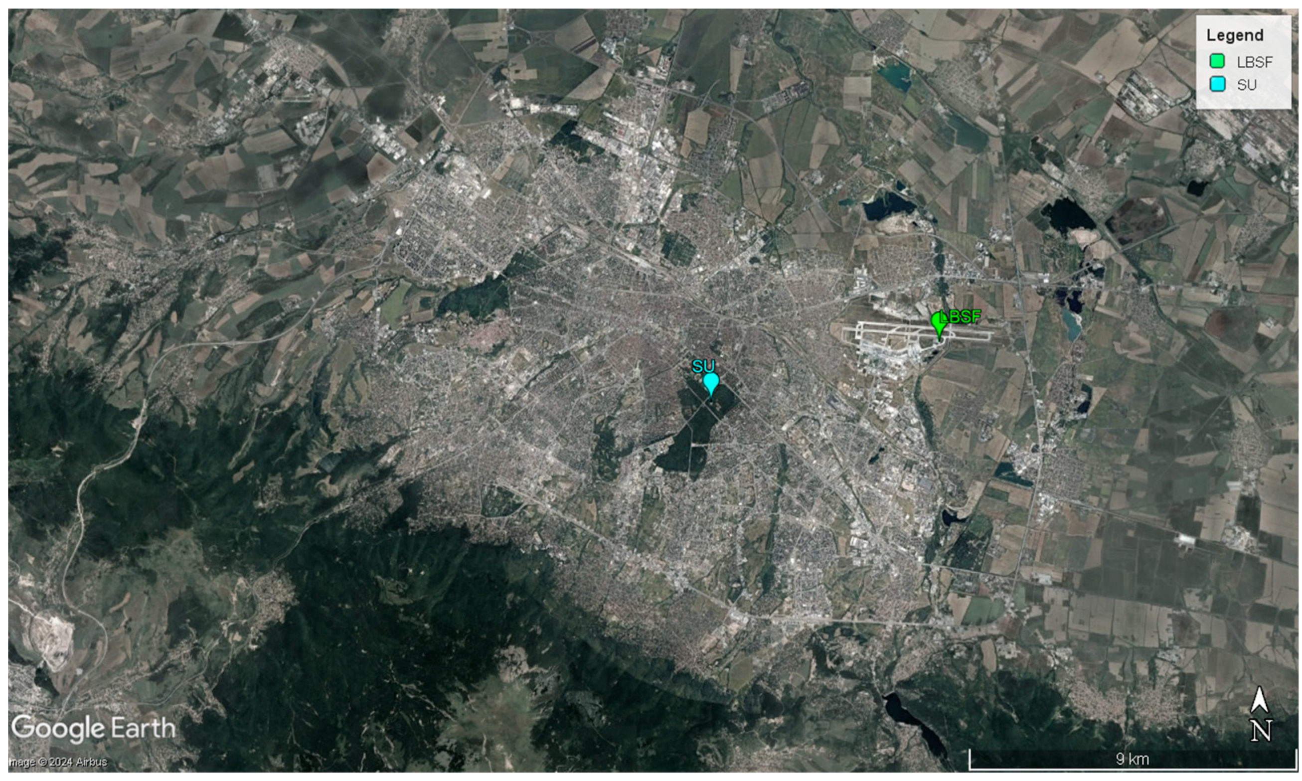
Figure 1. Locations of SU (cyan) and LBSF (green) stations. Both stations are equipped with an AWS and a ceilometer (Source of the map is Google LLC).
Environsciproc 29 00045 g001
Figure 2. Seasonal variation in the daily LCL cycles at LBSF (airport) and SU (park in the city center) stations. LCL is used as a proxy of CBH.
Environsciproc 29 00045 g002
Figure 3. Seasonal variation in daily CBH cycles at LBSF (airport) and SU (park in the city center) stations. CBH values were measured by a ceilometer at each location.
Environsciproc 29 00045 g003
Figure 4. Seasonal variation in daily cloud persistence cycles at LBSF (airport) and SU (park in the city center) stations. Persistence is expressed as a ratio of the number of low clouds registered by the ceilometer (CBH < 2500 m) to the total number of measurements.
Environsciproc 29 00045 g004
Disclaimer/Publisher’s Note: The statements, opinions and data contained in all publications are solely those of the individual author(s) and contributor(s) and not of MDPI and/or the editor(s). MDPI and/or the editor(s) disclaim responsibility for any injury to people or property resulting from any ideas, methods, instructions or products referred to in the content.