1. Introduction
Flood risk management and protection infrastructure does not comprise an exclusively technical subject. The implementation of flood risk management strategies and their societal integration and acceptance necessitate flood governance. The catchment area of the project, the Strymon River basin in northern Greece, has suffered numerous flood events of varying importance in the past decades with consequences on the natural and socioeconomic sectors. At the European Union (EU) scale, the gradual employment of the Water Framework Directive (WFD) (EC 2000) since the early 2000s and the Directive on the Assessment and Management of Flood Risks (EC 2007), commonly known as the Floods Directive (FD), have provided a critical legislative framework that has led to the development of operational tools, such as the Flood Risk Management Plans (FRMPs) [
1].
The FRMPs are the first step in compliance with the European Legislation in the hierarchical pyramid of flood management and protection. Their objectives set for flood risk management focus on reducing the potentially negative consequences that floods have on human health, the environment, cultural heritage, and economic activity, as well as on initiatives to reduce flood occurrence [
2]. Although they offer a fundamental plan, their macroscopic perspective in terms of scale does not always give precise results when dealing with large-scale areas.
In order to assess the necessity of flood protection infrastructure on a local scale, further technical and operational data should be coupled together with those derived by the FD. These data include specific information on infrastructure with the site-specific location, structural characteristics, the initial cost of construction, performance, the response to flood events, and the cost of maintenance and reconstruction.
In cases in which structural flood protection measures fail to serve flooding inhibition, the results may affect different sectors, depending on the intensity and extent of the flood event [
3]. Material damage is the most common consequence of infrastructure failure, and it has a direct economic impact in that it requires financial resources to be repaired or reconstructed in order to continue to provide the required amount of protection in the future.
The aim of the research is to demonstrate the importance of evaluating the operability of existing flood protection structures in future anti-flood planning at regional and local scale. The operability is evaluated as a synthesis of flood occurrences, cost of structures and cost of structures’ maintenance.
2. Materials and Methods
The tools for assessing the financial cost of repairing damage or failure of technical/structural works constructed for flood protection are critical assets in flood project management by the governmental authorities and public organizations engaged. These tools can provide spatial data linked to construction and repair costs for identifying problematic spots and areas that repeatedly show a structural inability to prevent flooding. Particularly, the identification of linkages among spatial data, costs of flood protection works and flood event occurrences could highlight the regions or locations that the current flood protection infrastructures are not effective since flood events continue to occur The outcome of such a process may lead to a flood risk assessment tool that can record information that supports decision-making procedures in order to formulate action and management plans related to flood planning [
4].
This study was part of the project “Evaluation of the performance and interoperability of flood protection intervention measures in the area of the Strymon river basin”, which was implemented under the INTERREG V-A European Territorial Cooperation Program “Greece-Bulgaria 2014–2020 “Flood Protection—Cross Border Planning and Infrastructure Measures for Flood Protection”; this program aimed to combine the FRMPs with a thorough and detailed record and evaluation of the existing situation in terms of flood protection infrastructure to assess the majority of civil works and previously applied measures in order to evince the areas prone to flooding and provide an Action Plan, in which specific located measures were proposed according to a hierarchical evaluation.
2.1. Study Area
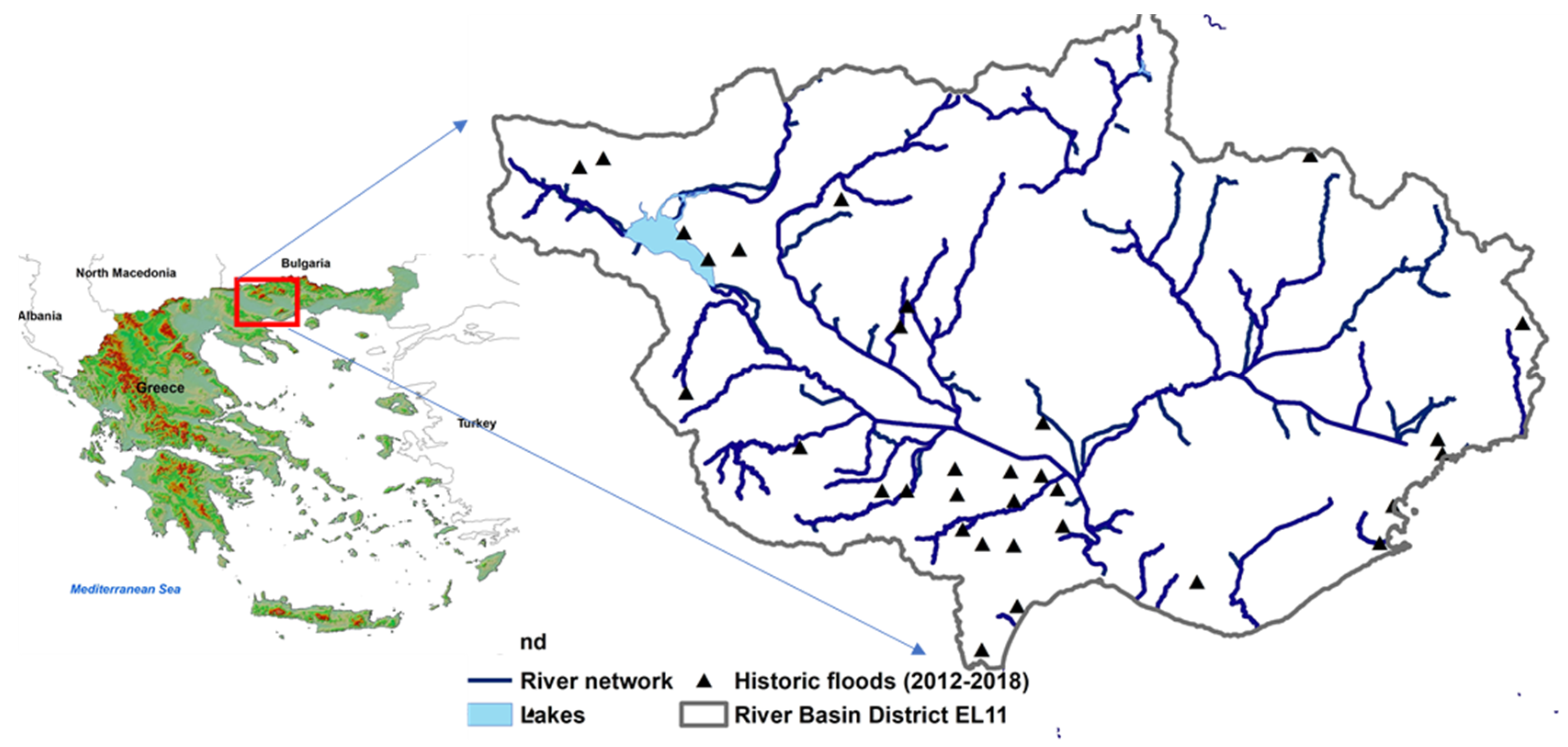
The study was implemented in the catchment area of the Strymon river, with an emphasis on places that show higher flood risk. Strymon is a river of the Balkan Peninsula with a length of 360 km, of which 242 km are in Bulgarian and 118 km are in Greek territory. The total hydrological basin has an area of 16,550 km
2, with only 6344 km
2 located in Greece [
5].
The area has suffered numerous flood events, with an increasing intensity of occurrence in the last decade. A results-based approach offers a tool for priority-based planning in which the initial cost of investment in the construction of flood protection work is related to the potential economic failure consequences and the repeated costs of maintenance. Numerous flood events, with an increasing tense of occurrence in the last decade [
6] is presented in the case study area, with
Figure 1 presenting all the flood events during the period 2012–2018 where official data are available [
7].
2.2. Methodology
The methodological approach constituted of the elaboration of the following actions and activities:
Development of a geospatial system containing baseline information on all the necessary data [
8] (backgrounds, networks, structures, flood events, flood zones, etc.);
Recording of the existing legal and institutional framework and its integration into the geospatial system [
8] (protected areas, land uses, special zones, special infrastructure, etc.);
Introduction of the areas/zones potentially at a high risk of flooding according to the FRMPs;
Determination of the TWI (Topographic Wetness Index);
Recording of existing measures from the regional and local action and flood protection management plans;
Recording of historical flooding phenomena and their damage assessment data;
Recording of the results of existing measures, interventions, and infrastructure, depending on their efficiency in flood events;
Determination of positive and negative effects of measures on the anthropogenic, natural, and economic environment;
Future projection of the operational capacity of the protection and intervention measures;
Cost estimation of protection/intervention measures and prioritization.
All data were introduced into a web GIS (Geographic Information System) for visualization and analysis.
3. Results and Discussion
In cases in which past construction data are needed, the main obstacle is the scattered records among the responsible public authorities and the lack of service files. Despite the difficulty of the venture, 652 structural flood protection measures and civil works were recorded in total through field surveys and file searches, constituting the first effort of such a scale in the Greek territory.
These structures were further divided into 21 subcategories according to the type of structure and the frequency at which they occur in the river basin. The occurrence frequency is indicative of the structural type preferred and most constructed in the area.
Figure 2 illustrates all categories of structural measures as well as their types and occurrence frequencies in the study area.
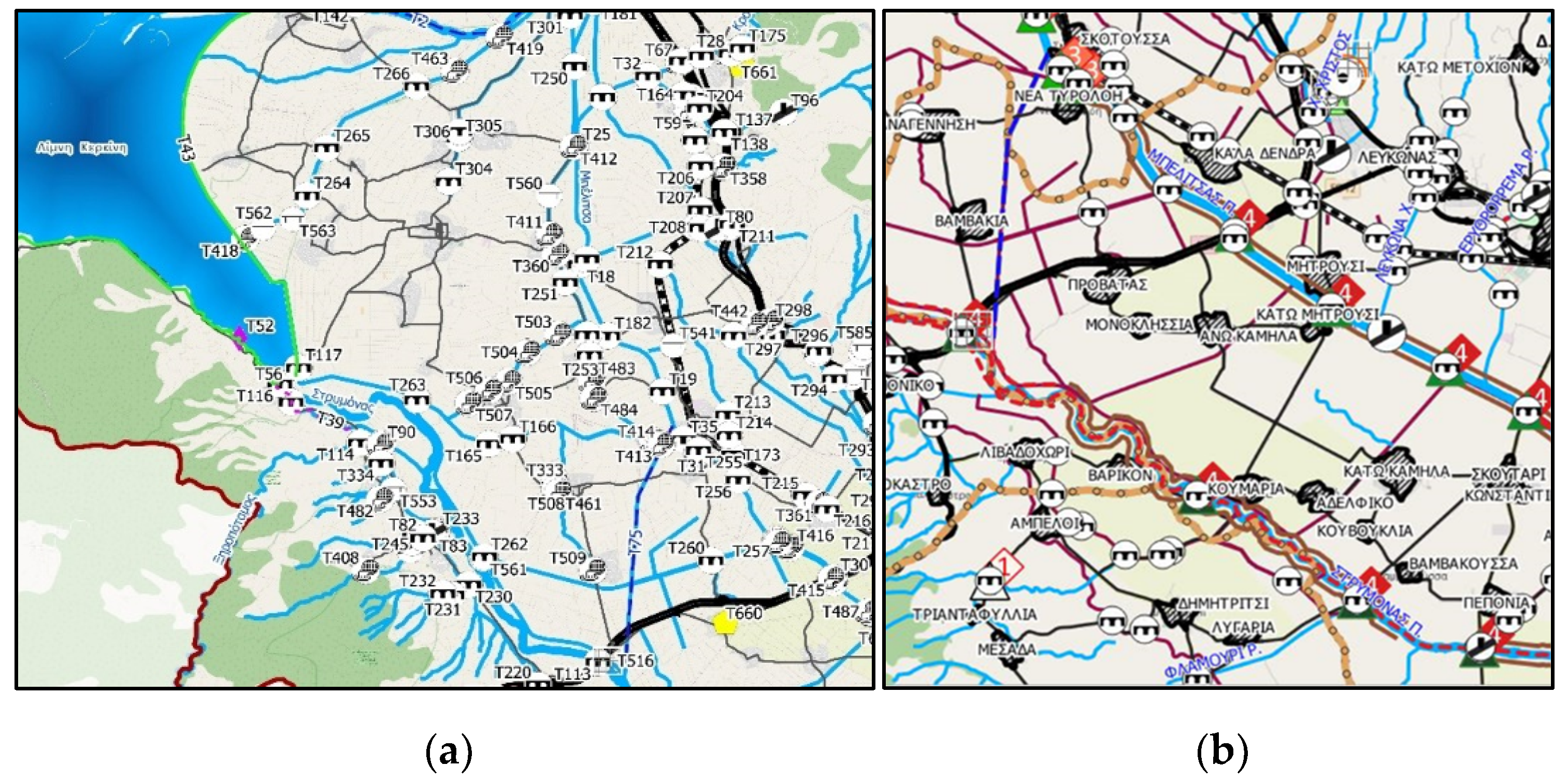
All aforementioned data were mapped in QGIS while the geodatabase was populated with information relative to each structure, such as the construction date, cost, maintenance frequency, failure, damage, repair cost, and interoperability with other structures.
Figure 3a–c show the mapping outcome of the structure data and their reclassification into six main categories—(i) restoration work, (ii) urgent projects, (iii) dredging work, (iv) cleaning work and work on technical islets (in rivers), and (v) alluvial removal work— according to the type of maintenance necessary over a period of 5 years. Maintenance work included any kind of intervention needed once, while the repeatability of maintenance in a specific structure/location was also recorded, thus providing an index of vulnerability and poor resilience of each structure to flooding events (
Table 1).
In total, all 652 recorded flood protection structures showed a repetitive need for intervention actions to be taken due to possible failure or unsuccessful operation at an approximate rate of 1:3, while in most cases, maintenance work needed to be repeated with the reverse rate of 3:1. Two categories proved to show more vulnerability and less of an ability to perform well in potential flooding: (a) restoration work in critical flood protection infrastructure and (b) bridges and stream crossings.
The above were introduced into the GIS model in order to determine the spatial distribution of the data and have a visual outcome that yielded critical locations subject to further study; these locations showed an increased vulnerability to flooding events, as demonstrated by the data.
Figure 3 presents the mapping outcome of infrastructure data visualization (a) and reclassification, with the repeatability of maintenance marked for each structural work (b) related to the number of interventions.
In addition, important information on the initial cost of infrastructure and the maintenance cost was collected. While the initial cost was not always available due to the construction in past years, the maintenance costs for the past decade were easier to obtain. The analysis of the outputs is depicted in
Figure 4.
The first time a flood protection task is implemented, the restoration work showed a significantly higher cost of EUR 431,000.00, while the repetition of the work/intervention measures placed the interventions in bridges and culvers in the first place with a significant difference. The work on islets showed the lowest cost, implying that it has not yet been necessary to modify them (based on repeatability). The total approximate cost for the maintenance of flood work only rose to EUR 42,711,000 in a 5-year period.
The significance of the structural work and the prioritization of needs in new flood protection infrastructure was also correlated with the FRMPs; all data were overlayed with the food risk zones to spatially determine the most vulnerable infrastructure [
9] so as to hierarchize potential interventions.
4. Conclusions
Flood events (major and minor) are inevitable, regardless of the amount of existing protection. Flood protection is critical, yet the financial cost of maintaining high levels of protection can prove rather excessive. In major flood events, failures occur, often at different locations each time depending on the spatial distribution and evolution of the phenomenon. However, it is possible to take into account the parameters that highlight the weaknesses and the problematic or insufficient flood protection design so that rational and reliable alternative proposals and solutions emerge.
From the correlations and analyses of the data in this study, it was derived that an important element for the spatial determination of the new measures is the infrastructure already developed for flood protection. The study showed that, despite the existence of multiple structural measures/work, many of them show poor efficiency, as shown by the high rate of repeated maintenance and its cost.
The methodology followed in this study was based on the results of the performance of existing flood protection measures, their characteristics, and their spatial correlation. The evaluation of structural measures by assessing their vulnerability via their yearly maintenance implemented the economic loss and financial impact that flooding events might have on infrastructure. The new measures should be related to the cost of construction and maintenance each time, applying the rule of cost–benefit [
10] and life cycle analysis, and infrastructure that costs more to maintain should be replaced.
Author Contributions
Conceptualization, E.T.; methodology, E.T., C.S. and A.C.; software, E.T., C.S. and A.C.; validation, E.T., C.S. and A.C.; formal analysis, E.T., C.S. and A.C.; investigation, E.T., C.S. and A.C.; resources, E.T., C.S. and A.C.; data curation, E.T., C.S. and A.C.; writing—original draft preparation, E.T.; writing—review and editing, E.T. and C.S.; visualization, E.T. and C.S.; supervision, E.T. and C.S.; project administration, E.T.; funding acquisition, E.T. All authors have read and agreed to the published version of the manuscript.
Funding
This research was funded by the INTERREG V-A European Territorial Cooperation Program “Greece-Bulgaria 2014–2020 Flood Protection—Cross Border Planning and Infrastructure Measures for Flood Protection”.
Institutional Review Board Statement
Not applicable.
Informed Consent Statement
Not applicable.
Data Availability Statement
All data, models, and code that support the findings of this study are available from the corresponding author upon reasonable request.
Conflicts of Interest
The authors declare no conflict of interest.
References
- Directive 2007/60/EC of the European Parliament and of the Council of 23 October 2007 on the Assessment and Management of Flood Risks. Available online: https://eur-lex.europa.eu/eli/dir/2007/60/oj (accessed on 13 December 2022).
- WHO. Selecting Measures and Designing Strategies for Integrated Flood Management: A Guidance Document; Swiss Federal Office for the Environment, Netherlands Ministry of Infrastructure and Environment and Deltares: Delft, The Netherlands, 2017. [Google Scholar]
- Raadgever, G.T.; Booister, N.; Steenstra, M.K. Flood risk governance. In Flood Risk Management Strategies and Governance; Raadgever, T., Hegger, D., Eds.; Springer: Berlin/Heidelberg, Germany, 2018. [Google Scholar]
- Malczewski, J.; Rinner, C. Multicriteria Decision Analysis in Geographic Information Science; Springer: Berlin/Heidelberg, Germany, 2015; pp. 3–54. [Google Scholar]
- Skoulikaris, C. Transboundary Cooperation Through Water Related EU Directives’ Implementation Process. The Case of Shared Waters Between Bulgaria and Greece. Water Resour Manag. 2021, 35, 4977–4993. [Google Scholar] [CrossRef]
- Tolika, K.; Skoulikaris, C. Atmospheric circulation types and floods’ occurrence; A thorough analysis over Greece. Sci. Total Environ. 2023, 865, 161217. [Google Scholar] [CrossRef] [PubMed]
- Skoulikaris, C. Toponyms: A neglected asset within the water framework and flood directives implementation process; the case study of Greece. Acta Geophys. 2022, 1–15. [Google Scholar] [CrossRef]
- Coutinho-Rodrigues, J.; Simão, A.; Antunes, C. A GIS-based multicriteria spatial decision support system for planning urban infrastructures. Decis. Support Syst. 2011, 51, 720–726. [Google Scholar] [CrossRef]
- Peterson, S.J. Construction Accounting and Financial Management; Pearson Prentice Hall: Hoboken, NJ, USA, 2005. [Google Scholar]
- Hanley, N.; Splash, C.L. Cost of Benefit Analysis and the Environment; Edward Elgar Publishing Ltd.: Cheltenham, UK, 1993. [Google Scholar]
| Disclaimer/Publisher’s Note: The statements, opinions and data contained in all publications are solely those of the individual author(s) and contributor(s) and not of MDPI and/or the editor(s). MDPI and/or the editor(s) disclaim responsibility for any injury to people or property resulting from any ideas, methods, instructions or products referred to in the content. |
© 2023 by the authors. Licensee MDPI, Basel, Switzerland. This article is an open access article distributed under the terms and conditions of the Creative Commons Attribution (CC BY) license (https://creativecommons.org/licenses/by/4.0/).


