Proceeding Paper

The September 2019 Flash Flood Event in Eastern Spain: Synoptic Analysis and Extreme Rainfall Assessment †

by
Maria Sol Hernández-Conesa
1,*,
Igor Gómez
2,3 and
Guillermo Carballo-Lafuente
1
1
Faculty of Sciences, Faculty of Sciences, University of Alicante, Section 99, E-03080 Alicante, Spain
2
Department of Applied Physics, Faculty of Sciences, University of Alicante, Section 99, E-03080 Alicante, Spain
3
Multidisciplinary Institute for Environmental Studies (MIES) “Ramón Margalef”, University of Alicante, Section 99, E-03690 Alicante, Spain
*
Author to whom correspondence should be addressed.
Presented at the 5th International Electronic Conference on Atmospheric Sciences, 16–31 July 2022; Available online: https://ecas2022.sciforum.net/.
Environ. Sci. Proc. 2022, 19(1), 54; https://doi.org/10.3390/ecas2022-12800
Published: 14 July 2022
(This article belongs to the Proceedings of The 5th International Electronic Conference on Atmospheric Sciences)

Abstract

:
The western Mediterranean region is frequently affected by torrential rains, such as that developed between 10th and 13th September 2019. Accumulated rainfall above 400 mm considering the whole precipitation event as well as precipitation values close to 200 mm were recorded in some places in just 2 h. The synoptic environment of this event is characterized by an advection of easterly maritime winds focusing on the southeast western Mediterranean basin and the presence of an upper level isolated low over the area of intense torrential rainfall. In this study, the spatial distribution and temporal evolution of this rainfall event are analyzed.

1. Introduction

The western Mediterranean region is, due to its latitude, a transition zone between mid-latitude low pressure and subtropical high latitude [1]. Among the characteristics of the Mediterranean climate, we highlight its hot and dry summers, its mild and rainy winters and the torrential rainfall [2,3] since they represent one of the main potential causes of natural hazards in the area due to the losses and the damages caused by this phenomenon are extensive and frequent [4,5]. Likewise, the increase in precipitation intensities, that is notorious on the Mediterranean coast, stands out [6].
The presence of an extraordinarily deep cut-off low in the first half of September, precisely at the time when there is more energy available in the lower troposphere, would imply that the meteorological phenomena that occur will also be extraordinary as soon as the flow in lower layers provides the appropriate configuration. During the torrential rainfall episode that took place in the western Mediterranean basin from 10–13 September 2019 seven people lost their lives. The most affected areas were extensive areas of the Valencia Region, Murcia, Castilla-La Mancha and Andalucia. A first approximation made by the Valencian Government of the damage caused by the storm estimated the economic impact of the rains and floods at around 1500 million euros, which represents more than 1% of the regional annual GDP [7]. Due to the importance of this precipitation event in the indicated area, its most important features are analyzed, using two different sources of data: the ERA5 atmospheric reanalysis of the European Center for Medium-Term Weather Forecasts and permanent stations located in the Valencian and the Murcia Region, areas in which precipitation records were more extreme.

2. Materials and Methods
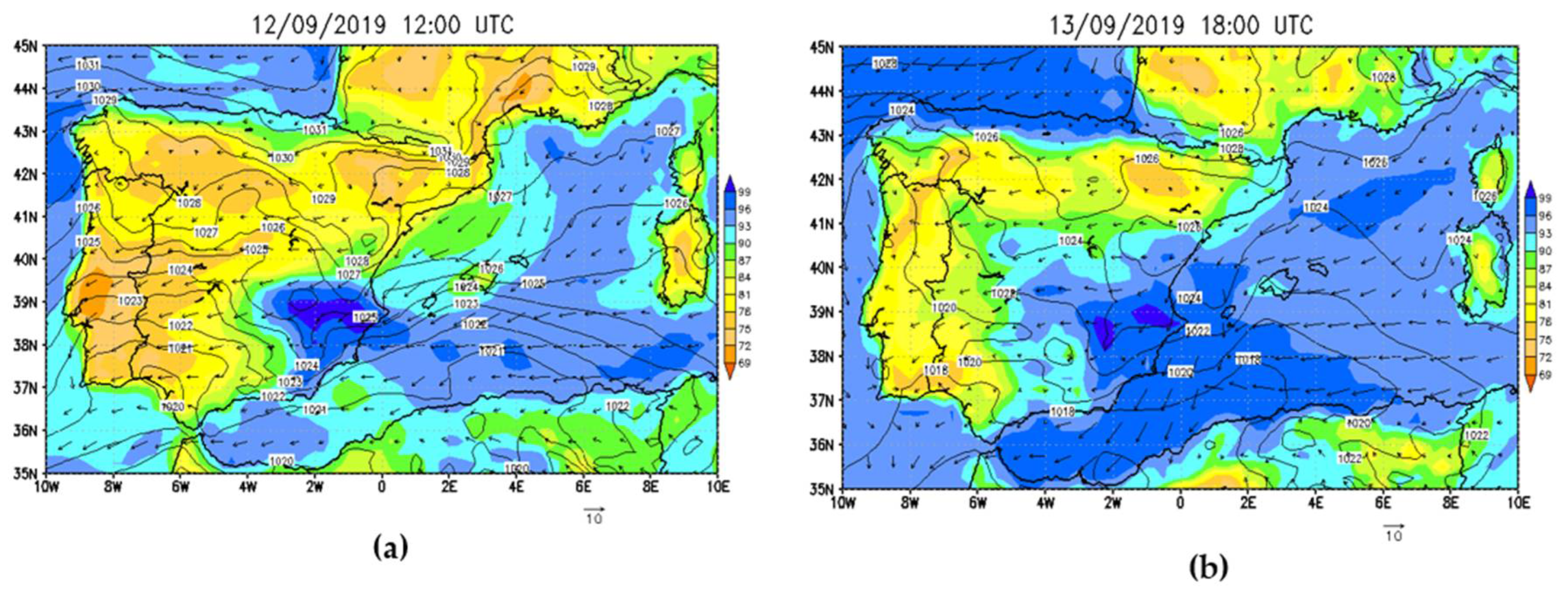
To carry out this study, different parameters obtained from the European Center for Medium-Range Weather Forecasts (ECMWF) were analyzed, through the atmospheric analysis ERA5 (European Reanalysis v5; [8]). ERA5 offers a higher resolution in space and time and assimilates more observational data sets than previous reanalysis, making it significantly more accurate [9]. From said reanalysis, pressure at sea level, wind at different pressure levels and surface variables, such as relative humidity, were used. These variables were chosen because they are essential factors to evaluate this torrential event, as well as being based on the fact that high percentage of humidity gives us information regarding cloudiness.
Finally, a specific analysis of accumulated and daily precipitation has been carried out in specific areas of the Murcia and Valencia regions to observe the degree of intensity of this parameter and, therefore, the magnitude of this event. To carry out this analysis, data obtained from the Ministry of Agriculture and Fisheries, Food and the Environment through the network of agrometeorological stations SIAR (Agroclimatic Information System for Irrigation) is used.

3. Results

On September 10 and 11 (Figure 1a), cold air pool descended from northern Europe towards the study region. In addition, this cold pool presented very low temperatures of up to −21 and −15 °C on the Mediterranean coast. It should be noted that the wind mainly came from the east of the Mediterranean. On the other hand, on September 12 (Figure 1b) the isolation of the cold pool created in the previous days can be seen in the South of Spain and in the North of Africa, with the similar characteristics of low temperatures and wind observed the previous days, with a temperature of −15 °C in the central zone of the low pressure. Subsequently, on September 13, this cool pool began to move, presenting low heights of between 5750 and 5700 m, towards the interior of the Peninsula. In addition, the east wind continued to affect the Mediterranean coast and the interior of the Iberian Peninsula. Temperatures were −18 °C in the center of the storm.
Observing this process in perspective, a feedback was detected related to the contribution of wind from two different areas within the study region, the formation of this isolated cold pool aloft that feed the observed torrential rains. On the one hand, a wind can be distinguished coming from the West of Spain, as the product of an anticyclone that later entered through the North of France and Spain and headed towards the Eastern Mediterranean coast. On the other hand, the presence of easterly wind from the Mediterranean Sea reinforced this feedback.
On 12 and 13 September, a high relative humidity was simulated by ERA5. On 11 September, a saturation of 96% begins to be observed north of Alicante Province and 90% over in the Murcia Region. Next, on the 12 September (Figure 2a), there is high relative humidity in the study area, both in the Alicante area and in the interior of Murcia Region, with values of 99% and 96%, respectively. This high relative humidity values are accompanied by an incident surface wind from the east of the western Mediterranean, with a great intensity due to the rapid variation of pressures. Subsequently, on the 13 September (Figure 2b), the same relative humidity percentages continued to be obtained in both study areas with less incident and weak winds on the coast of the study area, compared to those reproduced on the 12 September.
Accumulated rainfall over different weather stations is shown in Figure 3 and Table 1. Taking into account the different days, at the heaviest precipitation was recorded on the 12 and 13 September. On the one hand, among the various weather stations, Catral (193.5 mm) and Orihuela (154.8 mm) located in the Valencian Region were chosen, due to a large accumulated precipitation on the 12 September. For this day, in the Murcia Region, and with a great difference with respect to the other areas, the territory with the most accumulated precipitation was Torre Pacheco (127.2 mm). On the other hand, Orihuela (119.4 mm) recorded the higher precipitation scores in the Valencia Community. In addition, in the border between the Valencia and Murcia regions, that is, Pilar de la Horadada, a high amount of precipitation was observed on the 13 September, with accumulated values of 132.5 mm, compared to the other specific areas. Only Santiago de la Ribera with 158.8 mm surpassed Pilar de la Horadada that day.
Accumulated precipitation values reached 400 mm considering the whole event in some stations, with daily values exceeding 200 mm in some locations in just 2 h (Figure 4).

4. Discussion

The Valencia and Murcia regions are favorable areas for torrential rains, especially the northern and southern part of the Alicante Province. From 10 to 13 September 2019, extreme heavy rains occurred, especially on the 12 and 13 September, which caused significant economic losses, damage to infrastructure and some human casualties. This torrential episode was characterized by the interaction of various parameters, both in height and in surface area. In the first place, the presence of a low level of pressure in height and the advection of the wind, which came both from the west of Spain and from the east of the coast as an easterly wind. In addition, surface conditions were also favorable for the generation of this event. The surface wind added to the high moisture content gave rise to cloud formation and precipitation. The persistence of these environmental features persisted during the whole precipitation episode. Various authors [10,11,12] have identified these mechanisms observed in this study as the main cause of the torrential rains in the Valencian Region. The results found in this study allow us to have a better understanding of the episodes of intense rains that take place, recurrently, in the east of the Iberian Peninsula.

Author Contributions

Conceptualization, I.G. and M.S.H.-C.; methodology, M.S.H.-C. and I.G.; software, M.S.H.-C.; validation, M.S.H.-C., I.G. and G.C.-L.; formal analysis, M.S.H.-C. and I.G.; investigation, M.S.H.-C., I.G. and G.C.-L.; resources, M.S.H.-C.; data curation, M.S.H.-C.; writing—original draft preparation, M.S.H.-C.; writing—review and editing, M.S.H.-C., I.G. and G.C.-L.; visualization, M.S.H.-C.; supervision, I.G. All authors have read and agreed to the published version of the manuscript.

Funding

This research was supported by the Project PID2020-118797RB-I00 funded by MCIN/AEI/10.13039/501100011033 and by the Regional Government of Valencia through the project PROMETEO/2021/016.

Institutional Review Board Statement

Not applicable.

Informed Consent Statement

Not applicable.

Data Availability Statement

All data included in the manuscript are available upon request by contacting the corresponding author.

Conflicts of Interest

The authors declare no conflict of interest.

References

  1. Martín-Vide, J.; Moreno-García, M.C.; López-Bustins, J.A. Synoptic causes of torrential rainfall in South-eastern Spain (1941–2017). Geophys. Res. Lett. 2021, 47, 143–162. [Google Scholar] [CrossRef]
  2. Gómez, I.; Pastor, F.; Estrela, M.J. Sensitivity of a mesoscale model to different convective parameterization schemes in a heavy rain event. NHESS 2011, 11, 343–357. [Google Scholar] [CrossRef]
  3. Pastor, F.; Valiente, J.A.; Estrela, M.J. Sea surface temperature y torrential rains in the Valencia region: Modelling the role of recharge areas. NHESS 2015, 15, 1677–1693. [Google Scholar] [CrossRef]
  4. Peñarrocha, D.; Estrela, M.J.; Millán, M. Classification of daily rainfall patterns in a Mediterranean area with extreme inten- sity levels: The Valencia region. Int. J. Climatol. 2002, 22, 677–695. [Google Scholar] [CrossRef]
  5. Tapiador, F.J.; Marcos, C.; Sancho, J.M.; Santos, C.; Núñez, J.Á.; Navarro, A.; Adler, R.F. The September 2019 floods in Spain: An example of the utility of satellite data for the analysis of extreme hydrometeorological events. Atmos. Res. 2021, 257, 105588. [Google Scholar] [CrossRef]
  6. Olcina, J. Incremento de episodios de inundación por lluvias de intensidad horaria en el sector central del litoral mediterra- neo español: Análisis de tendencias en Alicante. Sémata 2017, 29, 143–163. (In Spanish) [Google Scholar] [CrossRef]
  7. Núñez-Mora, J.Á. Histórico temporal de lluvias en el sureste de la Península, 11 al 15 de septiembre de 2019. Rev. Tiempo Y Clim. 2019, 5, 1. (In Spanish) [Google Scholar]
  8. Hillebrand, F.L.; Bremer, U.F.; Arigony-Neto, J.; da Rosa, C.N.; Mendes, C.W., Jr.; Costi, J.; de Freitas, M.W.D.; Schardong, F. Comparison between atmospheric reanalysis models ERA5 and ERA-Interim at the North Antarctic Peninsula region. AAG/A 2021, 111, 1147–1159. [Google Scholar] [CrossRef]
  9. Gómez, I.; Niclòs, R.; Estrela, M.J.; Caselles, V.; Barberà, M.J. Simulation of extreme heat events over the Valencia coastal region: Sensitivity to initial conditions y boundary layer parameterizations. Atmos. Res. 2019, 218, 315–334. [Google Scholar] [CrossRef]
  10. Millán, M.; Estrela, M.J.; Caselles, V. Torrential precipitations on the Spanish east coast: The role of the Mediterranean sea surface temperature. Atmos. Res. 1995, 36, 1–16. [Google Scholar] [CrossRef]
  11. Pastor, F.; Estrela, M.J.; Peñarrocha, D.; Millán, M.M. Torrential rains on the Spanish Mediterranean coast: Modeling the effects of the sea surface temperature. J. Appl. Meteorol. Climatol. 2001, 40, 1180–1195. [Google Scholar] [CrossRef]
  12. Millán, M.M.; Estrela, M.J.; Miró, J.Y. Rainfall components: Variability y spatial distribution in a Medi terranean Area (Valencia Region). J. Clim. 2005, 18, 2682–2705. [Google Scholar] [CrossRef]
Figure 1. (a) Geopotential height (m, shaded color), temperature in °C (solid green line) and wind (arrows) at 500 hPa on the 11 September 2019 at 12:00 UTC; (b) geopotential height (m, shaded color), temperature in °C (solid green line) and wind (arrows) at 500 hPa on the 12 September 2019 at 12:00 UTC.
Environsciproc 19 00054 g001
Figure 2. (a) Sea level pressure (contour, mb), wind (arrow, m/s) and relative humidity (shaded, %) on the 12 September 2019 at 12:00 UTC; (b) sea level pressure (contour, mb), wind (arrow, m/s) and relative humidity (shaded, %) on the 13 September 2019 at 18:00 UTC.
Environsciproc 19 00054 g002
Figure 3. Representation of the accumulated precipitation by means of a diagram in the different study areas of the Valencia and Murcia regions for the days 11, 12, 13 and 14 September 2019.
Environsciproc 19 00054 g003
Figure 4. Temporal evolution of 24 h of accumulated precipitation (mm) from 00:00 a.m. to 12:00. p.m. to 00:00 p.m. during the days 11, 12, 13 and 14 September 2019.
Environsciproc 19 00054 g004
Table 1. Data of 24 h of accumulated precipitation (mm) from 00:00 a.m. to 00:00 p.m. during the days 11, 12, 13 and 14 September 2019.
PRECIPITACIÓN ACUMULADA
11/09/201912/09/201913/09/201914/09/2019
Crevillente0114.310.1512.59
Catral0193.516.6619.6
Orihuela0154.8119.46.23
Villena11.9423.488.958.16
Villajoyosa19.523.684.1820.7
El Pilar0112.7132.51.39
Yecla5.3431.2310.1917.95
Abanilla11.9423.488.950
Mula6.479.58.39.8
La Ribera066.2158.84.1
Torre Pacheco0127.21093.6
Cieza194.191.239.7
Publisher’s Note: MDPI stays neutral with regard to jurisdictional claims in published maps and institutional affiliations.

