1. Introduction
Apartadó is a territory marked by the presence of ancestral communities and is considered a biodiversity hotspot. The city is highly vulnerable to the effects of climate variability and change with climate projections, indicating an increase in precipitation and temperature in an already humid area.
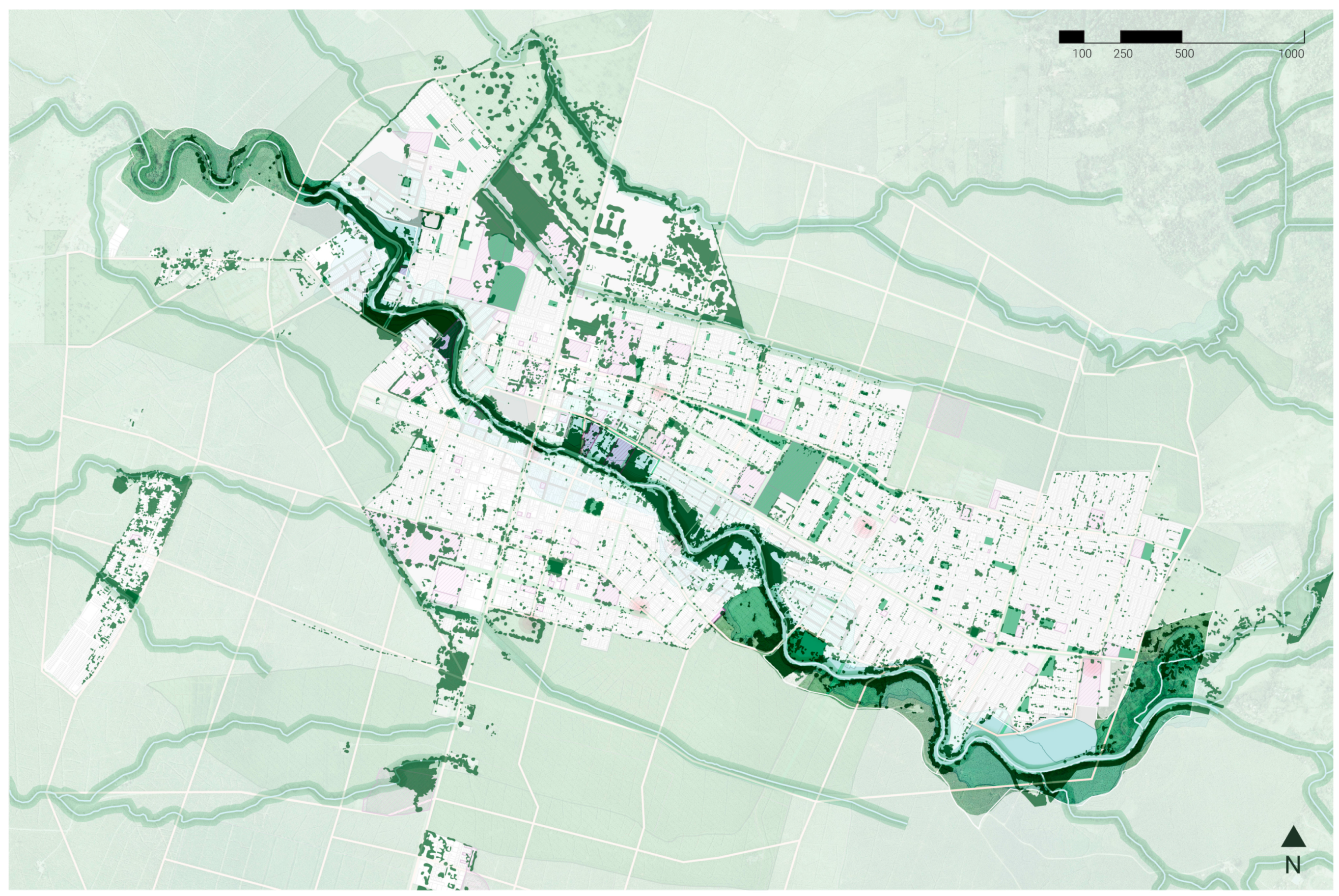
Apartadó is named after the suffix Dó, which comes from the indigenous Emberá word for river, with the Apartadó river crossing the city from east to west (
Figure 1). The river’s source is located in the Abibe mountain range at 1000 m above sea level, and it flows about 50 km into the Urabá Gulf in the Atlantic Ocean. Since the city was established on the river’s floodplain, it has increased its susceptibility to flooding by reducing its drainage capacity [
1] (p. 103).
The proximity to the river in the urban area has exposed communities to severe flash flooding events that occur approximately every 6 to 10 years. As many as half of the urban neighborhoods are affected by the natural flooding area of the river. With precipitation projected to increase around 10% due to climate change, extreme weather events associated with the river will also become stronger and far more frequent [
2].
The Master Plan will intervene 135 hectares along 4.5 miles of the river basin. It hopes to replant the river basin and use nature-based solutions to mitigate risk in the urban area, to strengthen resilience to flash flooding events. The project will also triple the green space per inhabitant by proposing complementary urban green spaces along the river basin [
3].
2. Regional Context
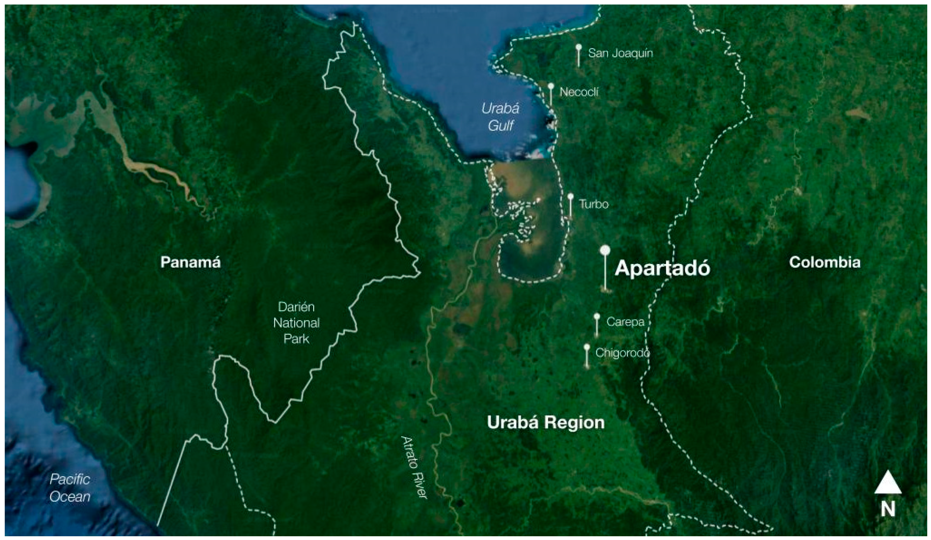
The municipality of Apartadó is located in the Urabá region within the department of Antioquia, in the northern part of Colombia (
Figure 2). It is characterized by its strategic location and its potential based on biodiversity. The region is part of the American intertropical zone. It is home to one of the 36 biodiversity hotspots recognized by the IOC (International Conservation Organization), known as the Tumbes-Chocó-Magdalena corridor. This area is home to 10% of the planet’s biodiversity [
1] (p. 17) and allows a biological exchange between North, Central, and South America. This is reflected in the 500 and 1000 million individuals of birds that cross the area annually, as well as in the humpback whales and Caná turtles [
1] (p.18).
The ecological structure of Urabá has as its main features: the Atrato river basin with the mangroves at its mouth, the beaches of the Urabá Gulf, the Rionegro cove, and the Nudo de Paramillo mountain range from which the Serranía de Abibe is derived. The rivers that irrigate the main municipalities of the region are born in the Serranía de Abibe and discharge into the León River (Chigorodó, Carepa, Currulao, Guadualito, Turbo, Caimán Nuevo, Caimán Viejo, Bobal, Necoclí rivers, Apartadó, and Río Mulatos).
The Serranía de Abibe is a steep mountain range that causes the rivers to have narrow and canyoned valleys. When the channels reach the flat area, the speed of the water decreases, and the sediments are deposited, forming alluvial plains [
1] (p.103). This change in slope causes the rivers to meander, and the main flow is divided into several secondary drains. This condition also causes a natural deficiency in the drainage capacity of the river basins.
These geological conditions allow the water infiltration that descends from the mountains into an essential reserve of underground water known as an aquifer. The central recharge zone is located along the foothills and is the primary source of supply for the local industry (banana plantations) and more than 30 rural communities [
1] (p. 60). These rivers are then subjected to permanent impacts that compromise the sustainability of the water resource.
The Urabá region is also characterized by the confluence of cultures, in this case, the Caribbean, the Pacific, and the Andean, and the presence of Afro and indigenous communities. The region is home to 32 reservations with 72 indigenous communities of the
Embera Katio,
Embera Chamí,
Kuna, and
Zenú ethnic groups [
4]. It also houses six community councils of Afro-Colombian,
Raizales, and
Palenqueras communities [
5].
Regarding productive activities in the region, banana and plantain production stand out, accounting for almost 75% of the Colombian banana production [
6] and extensive cattle ranching [
1] (p. 37). Despite these activities, and although the banana industry represents an essential source of employment in the area [
1] (p. 64), the NBI (unsatisfied basic needs) indicators are worrying. In the case of Apartadó, there is a percentage of 14.4% of the population with unsatisfied basic needs [
7], and 2.99% of the population lives in conditions of misery [
7]. In addition to this, it is essential to mention that the Urabá region suffers from delays in infrastructure and institutional strength, which has led to informal land tenure and the susceptibility of the territories to armed conflict and forced displacement.
3. Climate Change in Apartadó
Colombia and the Urabá region are heavily prone to the effects of climate change. Even though Colombia emits 0.5% of the worldwide GHG emissions [
8], it will face major changes that require extensive adaptation strategies. This is to protect the country’s economy and the great number of endemic species that are hosted in Colombia’s ecosystems.
Recognizing the need to adapt to and mitigate climate change, the Antioquia department is the first to declare a climate emergency. As part of their action plan, the government of Antioquia has launched the initiative “parks of the rivers”, which aims to generate 50,000 square meters of new green public spaces [
9]. These parks will help with risk exposure and flooding protection along river basins that coexist with cities and municipalities. The Apartadó river Master Plan has been prioritized as one of the most strategic projects of this initiative because it combines the intervention of the Apartadó river and the update of the city’s zoning plan.
Even though the Urabá region is located in a biodiversity hotspot, it is one of the areas with the greatest loss of biodiversity in the country and holds high rates of poverty [
10] (p. 8). The region is experiencing the effects of climate change already, and its temperature is expected to increase by 3 °C in the lowlands by 2100 [
10]. In the municipality of Apartadó, the situation is similar, with the temperature projected to increase by 1.8 to 2 °C between 2041 and 2070 [
11] (p. 35). When it comes to precipitation, Apartadó’s rain regimes will vary between −10% and 10% [
11] (p. 31), which will exacerbate droughts and the rainy seasons.
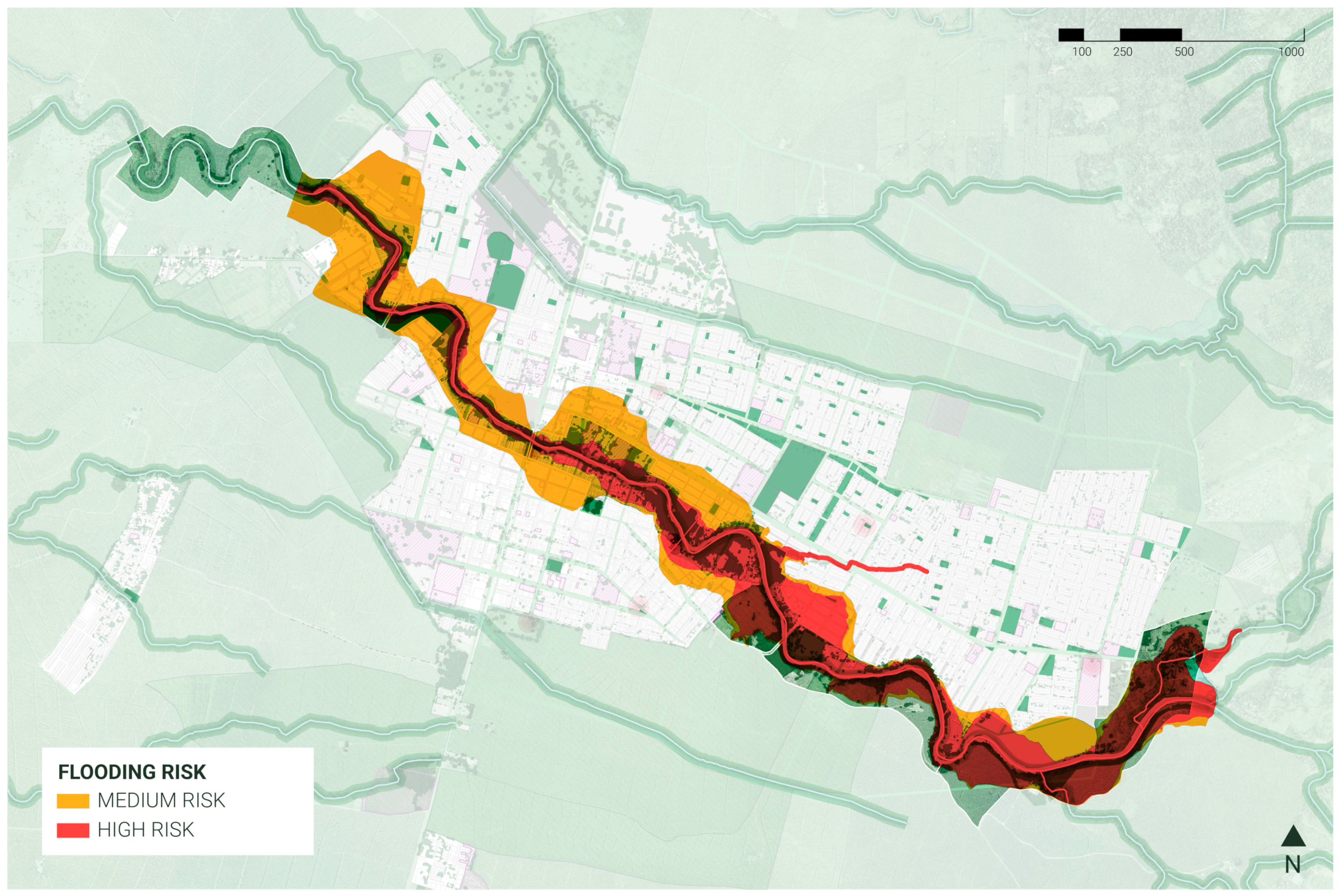
The increase in extreme weather events associated with climate change is critical for Apartadó since the city was established on the river’s floodplain. This condition has exposed communities along the river basin to severe flash flooding events approximately every 6 to 10 years. In Apartadó’s urban area, as many as 20 neighborhoods are affected by the natural flooding area of the river, which is equivalent to almost 50% of all urban neighborhoods (
Figure 3). With climate change expected to increase the probability of extreme weather events and precipitation patterns becoming more unpredictable, the flooding events of the Apartadó river are expected to become more frequent and extreme.
Adapting to climate change and achieving local risk management through sustainable land use and development will be key in helping Apartadó gain more resilience. With the inclusion of the Apartadó River Master Plan within the zoning plan of Apartadó, the city administration expects to mainstream climate adaptation in the urban and rural portions of the river while promoting environmental planning along the river basin.
4. Alignment with the Sustainable Development Goals
The Sustainable Development Goals (SDG) were adopted in 2015 as part of the 2030 Agenda for Sustainable Development proposed by the United Nations. The goals constitute an
‘urgent call for action’ [
12] to create a global partnership between all countries to achieve them. The seventeen SDGs were established without any hierarchy, giving them the same value and importance worldwide. However, other theoretical approximations of the SDGs provide differential scopes of their impact, as is the case of the ‘Wedding Cake’ approach proposed by the Stockholm Resilience Centre. This concept divides the SDGs into three ‘layers’ of action (‘economy’, ‘society’ and ‘biosphere’) that are interrelated and tackle different scales.
The idea behind the ‘Wedding Cake’ approach is to organize the goals to place planetary stability as the foundation of the development goals, followed by society, and ending with the economy at the top. This is to say that the SDGs need to be achieved within the planetary boundaries [
13] that have been defined by the scientific community to have a stable planet and atmosphere. These latter are a prerequisite for any society, and as follows, societies are a prerequisite to the economy. It is easier to understand their impact on a sustainable future by organizing the SDGs into these categories.
The foundational biosphere layer from the ‘Wedding Cake’ approach gains more relevance when considering that the most common category of the top ten risks identified by the
Global Risks Report 2021, 16th edition (both in likelihood and impact) are environmental risks [
14] (p. 12). This is coupled with the fact that the top three risks in terms of probability were assessed as extreme weather, climate action failure, and human environmental damage [
14].
When considering the biodiversity present in Colombia and the fact that the country has abundant water resources, framing sustainable development under a biosphere protection approach seems logical and highly pressing. This is why the Apartadó River Master Plan seeks to tackle mainly the SDGs associated with biosphere protection, which are SDG 6 (clean water and sanitation), SDG 13 (climate action), SDG 14 (life below water), and SDG 15 (life on land). It also contributes to SDG 11 (sustainable cities and communities), providing urban green spaces and contributing to urban resiliency through ecosystem-based adaptation.
The project’s alignment and achieving SDGs show the importance of urban and environmental planning initiatives. These initiatives contemplate not only more sustainable communities but understand the role of urban ecology and other ecological processes in the protection of the biosphere and ultimately guaranteeing a stable atmosphere.
5. Conceptual Framework
For the purposes of this paper, a master plan is understood as a dynamic long-term planning document that provides a conceptual design to guide future growth and development [
15]. It is also based on public sector input, surveys, planning initiatives, existing development, physical features, and social and economic conditions [
15].
In terms of climate adaptation, the term ‘urban resilience’ is understood by the description provided by UN-Habitat, which defines it as “
the measurable ability of any urban system,
with its inhabitants,
to maintain continuity through all shocks and stresses,
while positively adapting and transforming toward sustainability” [
16]. Resilience is also considered an accelerator for sustainable urban development [
16].
6. Methodology
The methodology for the Master Plan included three stages: due diligence, diagnostic, and formulation. The three stages contemplated community mapping and participatory planning workshops with different communities to understand their relationship with the river at a cultural and economic level and to identify their knowledge of ecological restoration.
6.1. Due Diligence
Due diligence for the project included reviewing the information provided by the city of Apartadó on subjects concerning biodiversity, risk management, previous urban design projects for the river, the zoning plan, the major’s development plan, and other regional initiatives related to climate change and economic growth.
The initial stage also included a resilience mapping exercise using an adaptation of the SAGE (Sustainable Adaptive Gradients in the Coastal Environment) framework for assessing resilience in infrastructure projects by framing the guiding questions of each of the Eight Gradients of Resiliency [
17] to extract the local issues of resilience from workshops with different stakeholders. The gradients were divided by stakeholders depending on their role in the municipality, and recurring themes between stakeholders were extracted to identify the Master Plan’s guiding principles.
6.2. Project Diagnostic and Approach
For the project diagnostic and approach stage, the methodology included analyzing and interpreting the information reviewed during due diligence and cross-analyzing it with information compiled through community outreach. The phase also included fieldwork and assessment along the river, especially in urban areas where erosion issues are more prominent.
Community mapping strategies were also implemented, focusing on a city scale to identify issues and proposals that needed to be incorporated into the zoning plan review while also assessing the information that could be tackled by the Master Plan on a smaller scale.
Finally, the project diagnostic and approach provided a report with key findings and recommendations to be included in formulating the Master Plan.
6.3. Formulation
The formulation of the Master Plan had, as a starting point, the essential findings and recommendations of the project diagnostic and approach, along with community outreach activities based on the five guiding principles for the Master Plan resulting from the resilience mapping. These workshops included the participation of ancestral communities, community leaders from the 20 neighborhoods impacted by the project, young leaders, and participatory planning entities.
The Master Plan seeks to tackle disaster mainstreaming with an environmental and climate justice approach. From a technical perspective, it was formulated with ecosystem-based adaptation strategies, such as forest protection and participatory ecological restoration, and using design principles based on “water sensitive cities”.
7. Results: The Master Plan
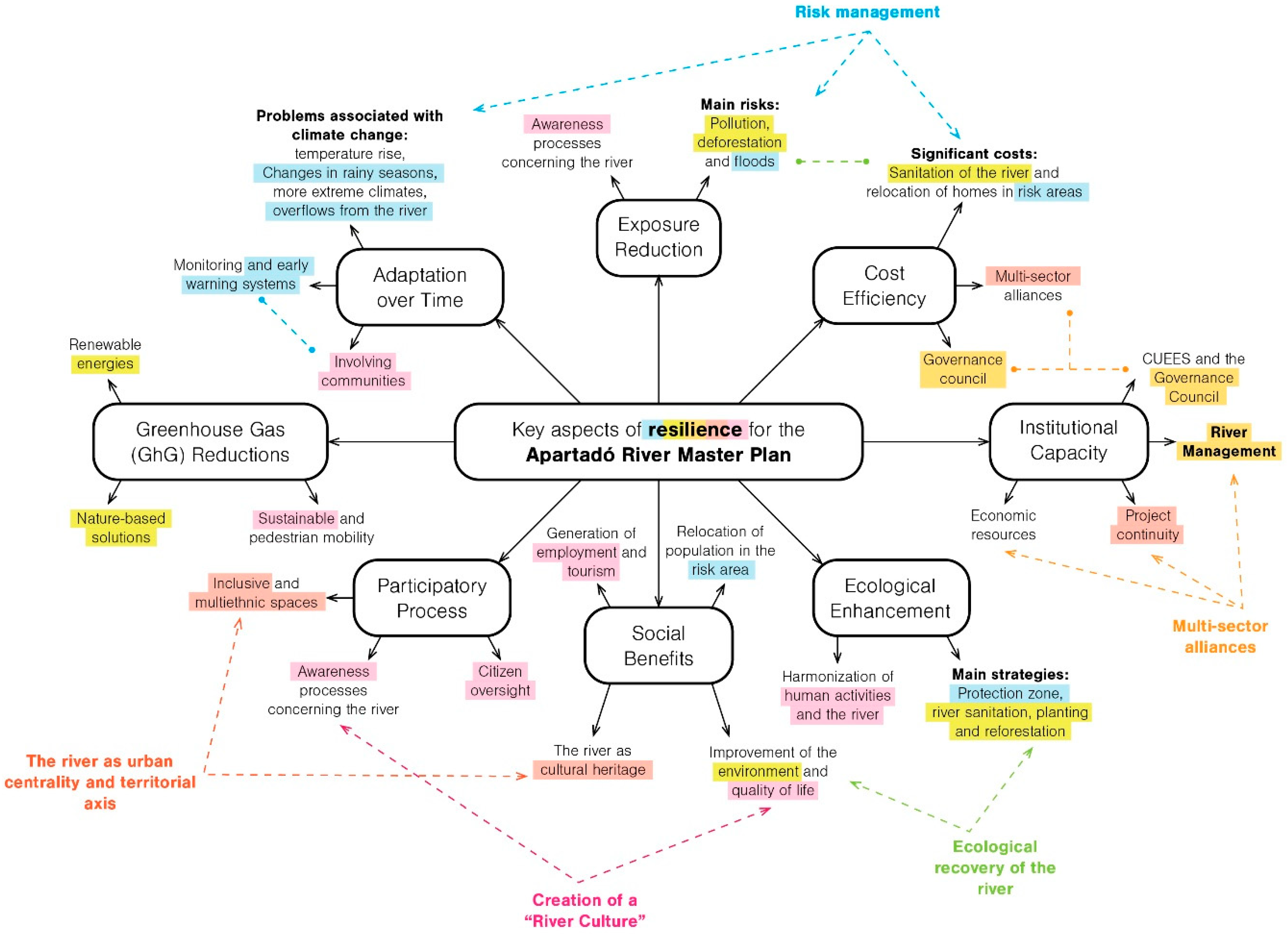
After analyzing the results of the resilience mapping exercise (
Figure 4), five recurrent topics constantly surfaced during community workshops about the river and its adaptative capacity. The key themes were identified after speaking with the different stakeholders and were identified as follows: (1) The importance of the river as a city landmark and an urban development axis; (2) the importance of risk management within the river basin; (3) the environmental damage caused to the river and the need for ecological restoration; (4) the lack of social appropriation surrounding the river (despite its ancestral and ecological importance); and (5) the weakened governance of the region that could prevent the project from being carried out in the long term.
From these five key themes emerged the five guiding principles for the Master Plan, which are summarized in the following concepts: The river as an axis for sustainable urban development, the river as an alive system (río vivo), the river as a safe system (río seguro), the river with a specific identity associated with it (río con identidad), and finally, the river as a project that becomes a reality for the city (río una realidad). These five principles resulted in five lines of action that guided the formulation of the Master Plan and the strategies associated with it. Since the principles are derived from the resilience mapping exercise, their lines of action are expected to tackle the major challenges the river faces in terms of urban resilience, climate adaptation, and risk management with a locally tailored approach.
In the following subsections, the document elaborates on the different actions and approaches in each line of action and how they contribute to mainstreaming disaster risk reduction.
7.1. The River as an Axis for Sustainable Urban Development
In terms of urban and regional planning, the main objective of the Master Plan is to make the Apartadó river the central element in the city’s planning and development strategy. The municipality has to revert decades of development tactics that ignored the river to achieve this. As a result, making the river an axis of sustainable urban development requires changes in zoning legislation, building codes, and land use policy, among others. Those above were tackled in the review of the city’s zoning plan, which was also carried out in 2021.
As a more specific approach, the variables formulated within the Master Plan were centered along the lines of creating a robust urban space network, defining the necessary civic amenities to place along the river, and incorporating a sustainable transportation system that could lessen GHG emissions while connecting the river to the proposed system of calm streets that spreads throughout the city.
7.2. The River as an Alive System
Considering the incredible amount of biodiversity in Apartadó, but also the pluri-diversity reflected in indigenous tribes, afro communities, and other cultures present in the city, community empowerment will be a crucial element in achieving ecological restoration.
The environmental strategy of the Master Plan is based on ecosystem-based adaptation and nature-based solutions, which were designed conjointly with these communities. Their knowledge is a crucial pillar of environmental restoration, as there is a strong connection between them and biodiversity conservation.
Some of the strategies mentioned above include:
Partnering with farming, indigenous and afro communities, and the different stakeholders in the river basin.
Participatory ecological restoration of the river’s banks, including cleaning, stabilization, and replanting.
Providing the communities with technical knowledge.
Reforestation processes, in hand with traditional indigenous doctors.
Planning workshops for the recognition of landmarks in the river’s basin.
Planting of ancestral medicinal plants.
7.3. The River as a Safe System
One of the most important findings during community outreach was that the historical management of the river basin and the deforestation processes carried out in the river’s source were affecting its overall resiliency. Specifically, when talking to ancestral communities, the most accepted idea about why the river became a threat was ecological degradation processes that increase sedimentation and erosion around the river basin.
When considering the different communities living close to the river, mitigating and preventing the risk of flooding is essential. Allowing these communities to coexist with the river safely is an opportunity to reach resilience while preserving the cultural and historical relationship they have sustained with the affluent for decades.
The main strategies for risk management include:
Formulating adaptation and resilience guidelines for the neighborhoods adjacent to the river. A strategy called the “eco-resilient neighborhoods”.
Creating green buffers and flood detention zones that work as public spaces.
Designing sustainable urban drainage systems (SUDS) adapted to the local environment and vegetation.
Prioritizing community councils and indigenous reservations for detailed risk studies.
7.4. The River with a Specific Identity Associated with It
The uniqueness of the Apartadó river is based on its abundant biodiversity and on the identity of the ancestral communities that live by the river. During participatory workshops, Indigenous and Afro-Colombian communities identified the river as historical and environmental heritage of their culture. They acknowledged that the degradation of the affluent was endangering some of their ancestral traditions. An example of these is the traditional indigenous games (similar to sporting events) in which communities use the river to practice apnea and rafting competitions. Indigenous communities can no longer take part in these traditional sports due to reducing the river’s flow and its contamination.
As a strategy to preserve the particular identity of the Apartadó river, the Master Plan seeks to promote ancestral representation through elements in urban design and activities within the park that highlight the historical activities carried out in the river basin. This includes traditional indigenous games and indigenous markets. It also provides community spaces to share ancestral knowledge. The plan also seeks to promote eco and ethnotourism associated with the river’s history and contemplates training community leaders to carry out these complementary economic activities.
Another recurrent theme is the lack of initiatives to protect the river and basin from ecological degradation from agro-industrial activities, public sewage management, and improper domestic waste management. The Master Plan seeks to approach ecological degradation by proposing a citizen oversight roadmap to promote accountability in public and private processes related to the river’s protection and conservation. Furthermore, the plan will implement an aggressive environmental education program that will incentivize communities to take better care of the river, including citizen science activities and community reforestation strategies.
7.5. The River as a Project That Becomes a Reality for the City
To carry out the Master Plan, the municipality needs to form multisectoral alliances. A strategy for achieving this is to identify the stakeholders with properties along the river basin and create public-private partnerships to carry out commercial and conservation projects along the river. Another strategy is the payment of urban transfers from other initiatives within the intervention zone for the Master Plan.
Urban transfers in Colombia are portions of land or resources that have to be destined by developers and promoters to create public spaces, civic buildings, transport infrastructure, and other public amenities. They provide effective urban support for real estate developments. By linking urban transfers to the Master Plan, resources for urban development can be concentrated along the river’s axis, improving its commercial value and funding other necessary actions, such as reforestation or the creation of new urban spaces.
The current administration aims to establish the Master Plan as a legal planning instrument that is also reflected in the new zoning plan for the city. However, technical studies still need to be carried out to consider the Master Plan a viable tool for long-term planning.
8. Closing Remarks
Implementing climate adaptation strategies that allow for mainstreaming disaster can be challenging for a city like Apartadó, with specific conditions tied to biological and cultural diversity. As was shown by the resilience mapping, addressing resilience issues for this type of setting, we need to consider risk management, governance issues, environmental degradation, social inclusion, and cultural representation.
The Apartadó River Master Plan seeks to encompass all these variables to help create a proposal that can strengthen disaster response within the city. It also seeks to promote climate and environmental justice strategies, cultural appropriation programs, and public-private partnerships to tackle low governance. The role that land use and urban planning play in climate adaptation is focused on urban interventions, socio-ecological strategies, and risk management.
The methodology used in this project also demonstrates the importance of centering adaptation interventions around communities and local stakeholders that can guide the narrative of disaster response while incorporating unique cultural elements to risk management. This allows for a climate and environmental justice approach that promotes social empowerment within communities and enables decision-support frameworks for the project.
Although resilience is often thought of in terms of risk management and disaster response, the Apartadó River Master Plan argues that true resilience can only be achieved when attending to the specific conditions of local communities. By strengthening resilience through tailor-made solutions within socio-ecological systems, development planning has higher opportunities of being successful in facing the challenges that the climate crisis will bring forward.

