1. Introduction
The development of pit lakes after the closure of mining activities is considered a rehabilitation factor that is globally qualified and considered an efficient environmental solution for minimizing the long-term impacts of surface mining activities [
1,
2]. Pit lakes are formed by water filling the open pit left upon the completion of mining operations. The creation and sustainability of pit lakes, which are considered small-scale hydrological catchments, constitute a multi-factor theme concerning hydrology, hydrogeology, climatic conditions, and many other parameters. Hydrogeological conditions turn out to be a crucial factor during mining excavations, considering that they could also define when and how rapidly the open pit voids fill with water after mine closure and influence the final steady-state water volume of the lake formed. Groundwater inflows and outflows in the water balance of the pit lakes are mainly affected by the piezometry of the aquifer systems that are in hydraulic connection with the lakes.
Most open pits eventually intersect the water table during mining operations. Consequently, appropriate dewatering measures are adopted to protect the mine during the operational phase. Generally, these measures include dewatering wells around the pit perimeter and pumping stations located in the pit sumps inside the pit [
1], aiming to pump water from the aquifer and remove rainwater from the surface. After the mine closure, the dewatering measures are ceased, allowing the water tables to rise and—in some cases—a pit lake is formed [
3]. Artificial flooding or natural hydrological processes such as precipitation or groundwater infiltration or lateral hydraulic connection with aquifer systems can cause these pits to fill up [
4]. This paper focuses on the Kyparissia Lignite Mine in Peloponnese, South Greece, where the hydrogeological conditions were the determining factor for ceasing lignite exploitation and the creation of the pit lake inside the mine void.
2. Materials and Methods
The Public Power Corporation of Greece (PPC) has exploited four lignite reserves in the Megalopolis lignite field in Peloponnese, South Greece: Kyparissia, Thoknia, Marathousa, and Choremi (
Figure 1). Today, only the Choremi Lignite Mine, conducting open-cast mining, is in operation.
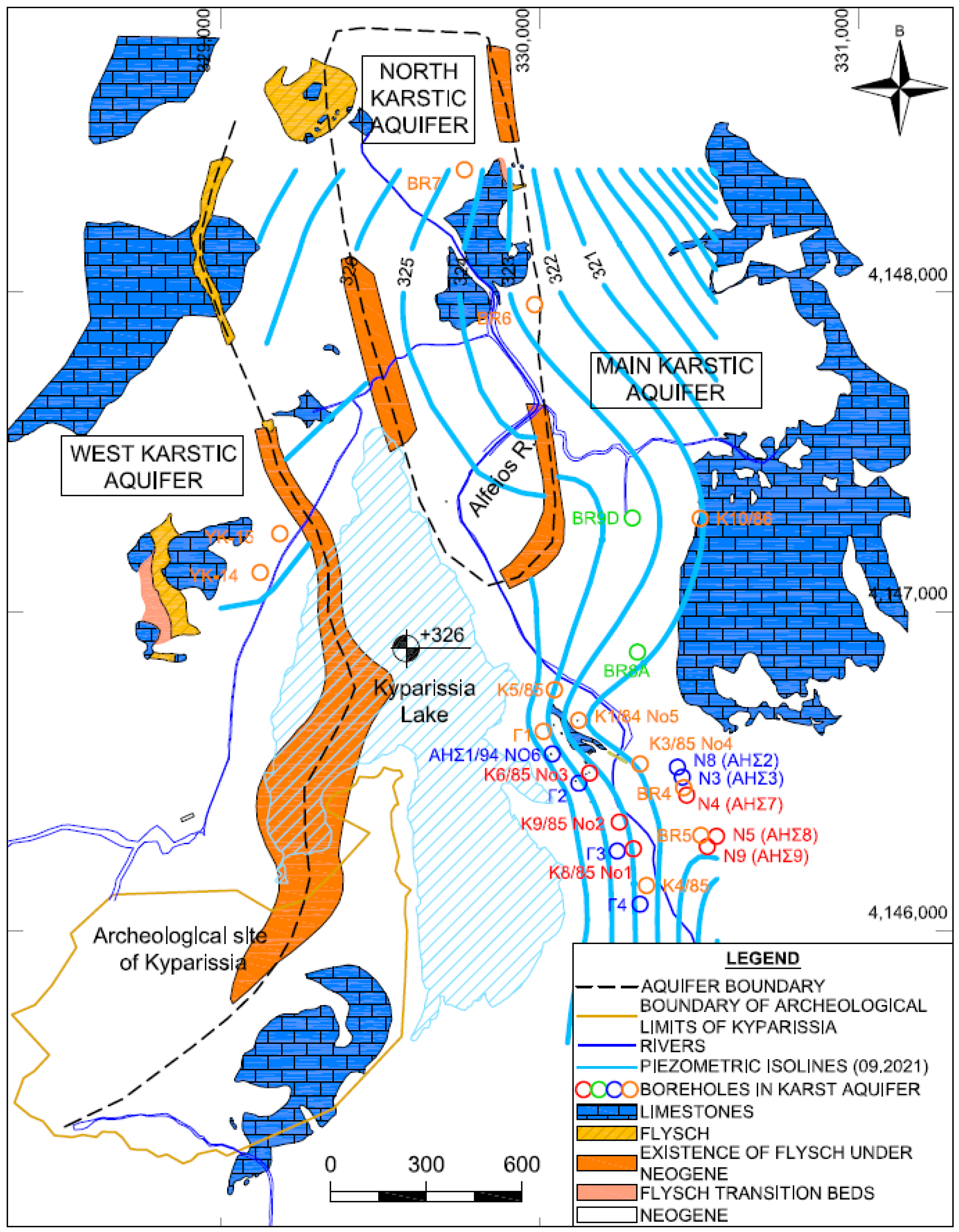
The Kyparissia Lignite Mine, located in the northern part of the Megalopolis Basin, is the most complicated mine in terms of hydrogeological conditions. Three karstic aquifers are developed in the Kyparissia Mine: (a) the North, (b) the West, and (c) the Main karstic aquifer. Interrupted by the flysch, they are separate. The karstic bedrock of the Upper Cretaceous is developed at a relatively shallow depth in the northern part of the mine. It is extended on the surface to the northwest and northeast, whereas it is laterally interrupted by the small discontinuities of the overlying flysch. In the northern part, the surface limestone sinks underground, with a gentle slope, and the karstic bedrock (Anticline of Sikalia) rises up [
5], leaving a very thin impermeable layer between the bottom of the exploitation and the karstic reservoir. This geological structure caused significant problems during the lignite exploitation in this part of the mine due to the capacity of the aquifer system. On the contrary, lignite exploitation towards the southern parts of the mine did not lead to such problems because the karst limestone expanded deeper. The hydrogeological conditions of this open pit were the determining factors for ceasing the exploitation, as the development of three karstic aquifers (Main, North, West) caused many problems.
Additionally, the Alfeios and Elissonas Rivers flow through the mines. Several diversions have been made in the bed of the Alfeios River to protect and properly operate the mines [
6]. Another crucial factor for ceasing the lignite exploitation in the Kyparissia Mine was the inflow from the Alfeios River. As a result, two pit lakes were formed, the North and the South, at the archaeological site (
Figure 2), where the karstic aquifer also discharged into the lakes. In 2006, continuous pumping was carried out for dewatering in order to continue the mine exploitation, but with no significant results. In 2012, the two lakes were joined into one due to the increase in precipitation. Later, from 2015 to 2016, continuous pumping was carried out, aiming to start lignite exploitation, but again without significant results. In total, a volume of 8.2 × 10
6 m
3 was pumped out from the pit lake during these two years.
3. Results and Discussion
The pit lake formed in the mine void has an average depth of 30 m and a maximum depth of approximately 36 m. The water volume is estimated to be 20 Mm
3, which extends to a surface of 0.8 km
2 [
2]. The lake is considered to be in an equilibrium phase, as the water table has been almost steady for the last 3–4 years. The created pit lake in Kyparissia is hydraulically connected with the main karstic aquifer, so the hydrogeological conditions of this aquifer determine the evolution of the pit lake.
The karstic aquifer covers an area of 120 km
2, of which 50 km
2 is occupied by the extended limestone deposit on the surface. The rest of the karstic bedrock sinks underground, with a gentle slope, and is covered with impermeable loose sediments of small thickness. Locally, in the Anticline of the Sikalia area (north side of the archaeological site in
Figure 2), the very small thickness of the loose sediments of the basin has increased the probability of the karstic groundwater discharge into the mine area. The karstic formations in the study area present infiltration coefficients in the order of 40–50%. Thus, the annual recharge volume is estimated to be in the range of 15–25 × 10
6 m
3 (period 2003–2021).
A total volume of 10.9 × 10
6 m
3 was pumped out from the main karstic aquifer of Kyparissia in 2021 in order to meet the water demands of power plants. The absolute elevation of the Main aquifer’s water table is +321.10 m asl, and the water table of the pit lake is +325.9 m asl (
Figure 2). The hydraulic characteristics of the main karstic aquifer are as follows: (a) transmissivity estimated from 10
−1 to 10
−2 m
2/s in the central and eastern part of the open pit and lower to the west, which enhance the recharge towards groundwater; (b) hydraulic gradient 0.6%, which favors the outflows of the lake to the karstic system in a volume of 3–10 × 10
6 m
3/y. The active porosity of the karstified limestone is estimated to be 0.6–0.7%.
According to
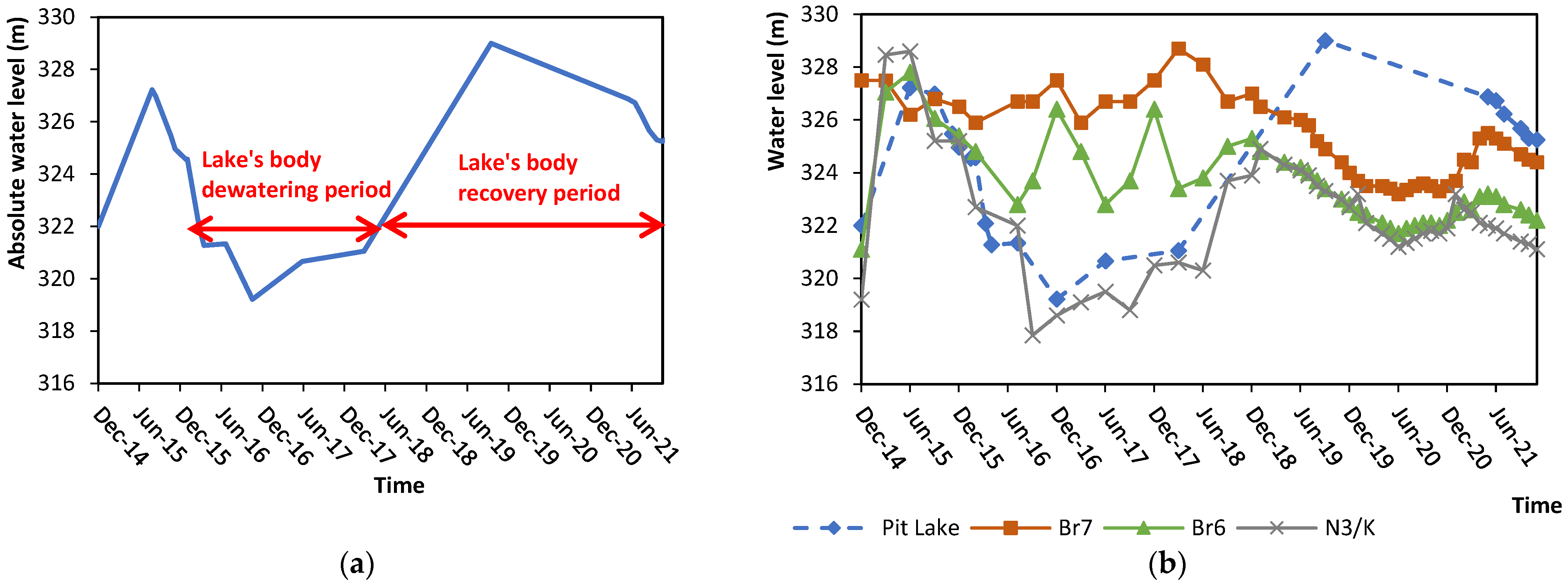
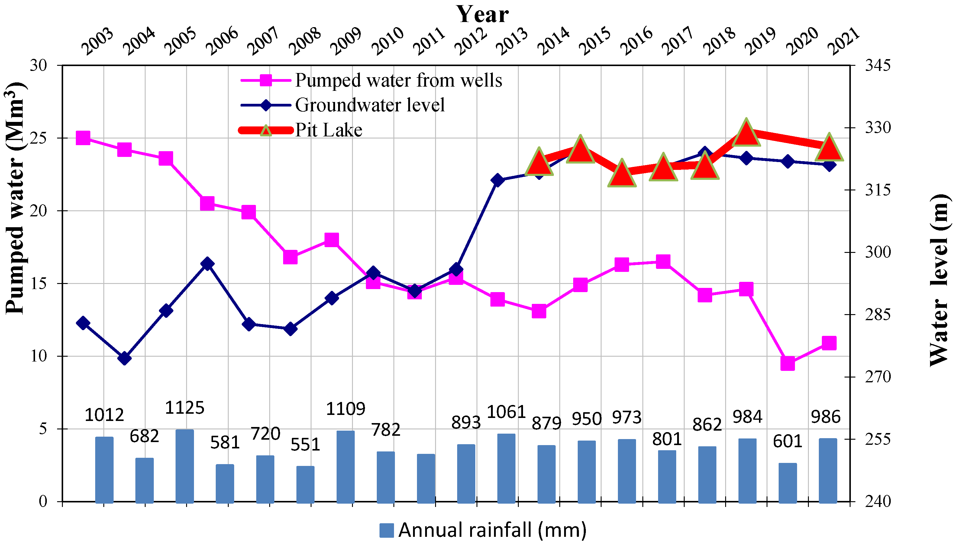
Figure 3a, the water level of the pit lake in Kyparissia Mine increased by almost 3.7 m during the 2014–2023 period. During the 2015–2016 period, when the lignite exploitation started again, the dewatering process affected the water level of the lake, pointing out the strong relation between the lake and the water table of the karstic aquifers. In the last nine years, precipitation has increased whereas the pumping of the karstic aquifers has significantly decreased.
In
Figure 3b and
Figure 4, the fluctuation of the water level of the three karstic aquifers in comparison to the water level of the pit lake in Kyparissia is presented. It should be noted that the water level of the pit lake is strongly dependent on the water level of the dewatering wells, mainly the N3/K well, which exploits the main karstic aquifer.
The cessation of dewatering and decreased quantities of pumping were both determining factors for the creation of the pit lake, in addition to the increased rainfall. The strong relation between the water level of the pit lake and the groundwater level of the three karstic aquifers (especially the main karstic aquifer–N3/K well) was defined using the multiple linear regression model.
Multiple regression analysis defined the mathematical equation between the pit lake’s water level and the groundwater level of the three dewatering wells; it is described as follows:
where
denotes the pit lake’s water level altitude, and
denotes groundwater level altitude, in a.s.l., of boreholes BR7, BR6, and N3/K, respectively.
The high determination coefficient R2 = 0.99 indicates that the hydraulic connection between karst piezometry and the Kyparissia lake is statistically significant, especially concerning the main karstic system perforated by the N3/K well.
In the last 15 years, a rise in the groundwater level of the main karstic aquifer has been observed. This confirms that the groundwater level drawdown due to dewatering is fully reversible. These conditions enhance the inflows to the pit lake. Consequently, the water level of the lake rises.
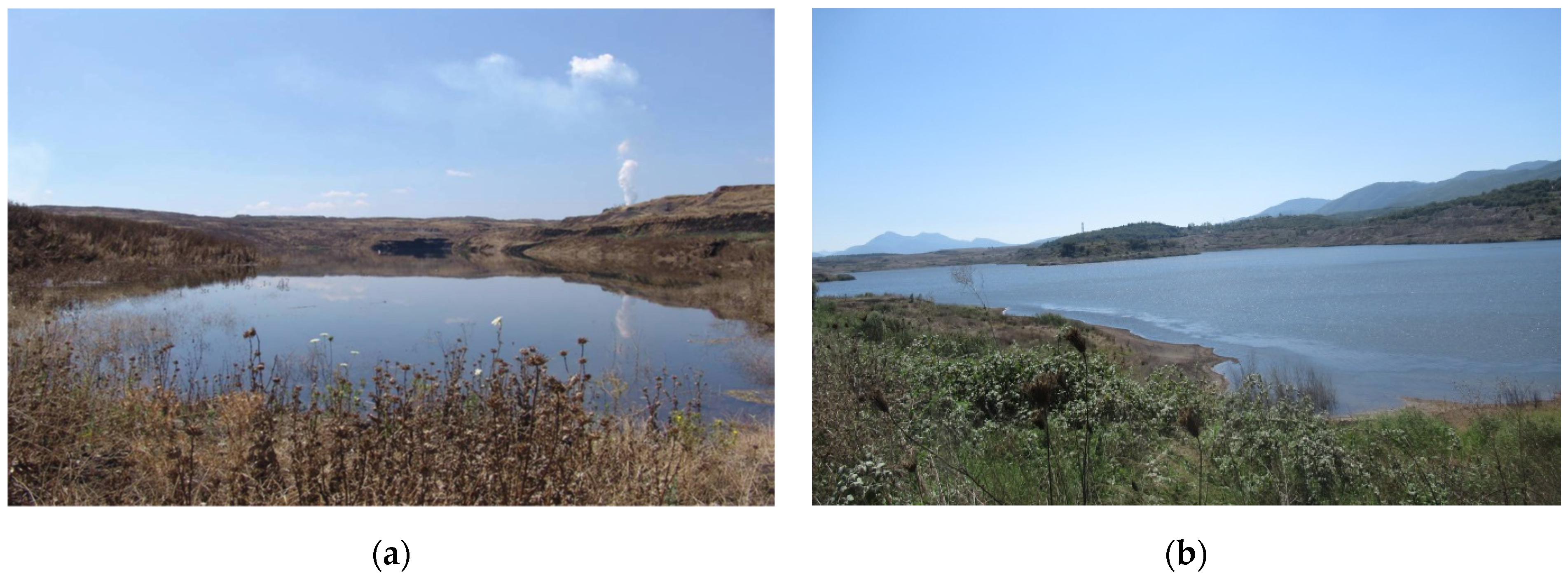
Figure 5 depicts the evolution of the pit lake over two time periods. In the second period, the recovery period, starting at the very beginning of 2019, the water level of the lake rose more and exceeded the karstic piezometry, imposing an outflow of water from the lake’s body towards the karstic reservoir.


