Article

Hydrothermally Altered Rocks and Their Implications for Debris Flow Generation in the Monarch Butterfly Biosphere Reserve, Mexico

by
Luis Ángel Jiménez López
1,
Juan Manuel Sánchez Núñez
1,*,
Antonio Pola
2,
José Cruz Escamilla Casas
3,
Hugo Iván Sereno
3,
Perla Rodríguez Contreras
4 and
María Elena Serrano Flores
1
1
Centro Interdisciplinario de Investigaciones y Estudios sobre Medio Ambiente y Desarrollo, Instituto Politécnico Nacional, Ciudad de México 07340, Mexico
2
Escuela Nacional de Estudios Superiores Morelia, Universidad Nacional Autónoma de México, Michoacán 58190, Mexico
3
Instituto de Ciencias Básicas e Ingeniería, Área Académica de Ciencias de la Tierra y Materiales, Universidad Autónoma del Estado de Hidalgo, Hidalgo 42039, Mexico
4
Departamento de Ingeniería Civil y Ambiental, Instituto de Ingeniería y Tecnología, Universidad Autónoma de Ciudad Juárez, Chihuahua 32320, Mexico
*
Author to whom correspondence should be addressed.
GeoHazards 2025, 6(4), 62; https://doi.org/10.3390/geohazards6040062
Submission received: 1 June 2025 / Revised: 12 September 2025 / Accepted: 23 September 2025 / Published: 2 October 2025

Abstract

Landslides are common in mountainous regions and can significantly affect human life and infrastructure. The aim of this study is to analyze the role of hydrothermally altered rocks in generating ground instability and triggering debris flows in the Canoas microbasin, Sierra de Angangueo, within the Monarch Butterfly Biosphere Reserve. We characterized the unaltered (andesite) and altered (andesitic breccia) rocks from the landslide scarp through fieldwork and laboratory analysis. The altered rock exhibited an extremely low simple compressive strength of 0.47 ± 0.05 MPa. In contrast, the unaltered rock exhibited a higher strength of 36.26 ± 18.62 MPa and lower porosity. Petrographic analysis revealed that the unaltered rock primarily consists of an andesitic groundmass with plagioclase and orthopyroxene phenocrysts partially altered to sericite and kaolin. In comparison, the altered rock contains a matrix rich in clay, iron oxides, and completely replaced phenocrysts. The andesitic breccia has a high proportion of clay and silt and displays soil-like mechanical properties, making it vulnerable to saturation collapse during heavy rainfall. This research offers valuable insights into geological risk management in mountainous volcanic regions. The findings demonstrate that the presence of hydrothermally altered andesitic breccia with weak geomechanical properties was the critical factor that triggered the Canoas debris flow, underscoring hydrothermal alteration as a key control of slope instability in volcanic settings.

1. Introduction

Mountainous regions have the highest concentration of landslides due to their slope, age, lithological composition, and structural state [1]. Landslides are morphodynamical phenomena that modify the topography and landforms of mountainous areas [2] and are a threat to human life and populations located in these regions [3,4]. Mexico has extensive high topography, and its geographic position makes it prone to the impacts of hydrometeorological phenomena (tropical storms and depressions, hurricanes, and cold fronts) that bring with them heavy rains that can trigger landslides. Over 90% of landslides in Mexico are triggered by rainfall [5].
A significant portion of the Mexican territory is dominated by volcanic rocks, with the Trans-Mexican Volcanic Belt representing the physiographic province that hosts the highest concentration of volcanoes [6]. Within this geological framework, hydrothermal alteration plays a central role as it fundamentally modifies the physical and mechanical properties of volcanic rocks, thereby regulating key processes such as fluid circulation, fracture propagation, and slope stability [7,8,9]. Alteration typically decreases porosity and permeability through mineral precipitation, which in turn promotes interstitial fluid pressurization and renewed fracturing. Conversely, the dissolution of hydrothermal phases may locally rejuvenate permeability networks [10,11]. These cyclic transformations alter the hydrodynamic and thermal regimes of hydrothermal systems, influencing stress fields, fracture networks, and the distribution of fluids and heat [9,12]. Consequently, hydrothermal alteration not only favors erratic volcanic behavior by restricting degassing and promoting pore-pressure build-up [13,14,15], but it also exerts a strong control on the geotechnical performance of volcanic edifices, particularly with respect to slope instability [16,17,18,19].
Evidence from several volcanic systems across the world demonstrates that these processes are critical drivers of catastrophic slope failures. At Mount Rainier (USA), deposits from the Osceola Mudflow contain abundant hydrothermally altered material, underscoring its role in the collapse of the summit edifice [16,20]. At Ruapehu volcano (New Zealand), the hydrothermal alteration of crater wall rocks has repeatedly contributed to landslides and lahars [18,19]. At Whakaari/White Island (New Zealand), pervasive alteration has produced an extremely weak volcanic edifice, responsible for recurrent flank collapses and explosive eruptions [14,19]. Similarly, in Shikoku (Japan), large landslides along the Median Tectonic Line have been directly attributed to hydrothermal weakening [21].
Collectively, these case studies confirm that hydrothermally altered volcanic rocks undergo critical reductions in strength, stiffness, and elastic properties, thereby conditioning their susceptibility to slope failure. This body of evidence highlights hydrothermal alteration as a fundamental process that links subsurface fluid–rock interaction with volcanic slope instability hazards, providing a crucial framework for understanding similar processes in Mexico and elsewhere.
Building on this global perspective, it is essential to evaluate how hydrothermal alteration contributes to slope instability in volcanic terrains of Mexico. In particular, the Sierra de Angangueo region in central Mexico provides a compelling case, where hydrothermally altered andesitic rocks have played a critical role in recent landslide processes.
This study focuses on a debris flow that occurred in February 2010 and severely impacted the town of Canoas in the Sierra de Angangueo region of central Mexico [22] (Figure 1). The Canoas debris flow was one of several debris flows in the region that were triggered by atypically high rainfall caused by low-pressure storms from the Pacific Ocean, triggered by Cold Front 29 and Winter Storm 5 [23].
Landslides initiate when the forces acting on terrain slopes exceed the strength of the materials composing them. As a result, it is critical to understand rock and soil mechanical properties and how they react to changes in stress–strain states to mitigate landslide hazards [24]. Rock samples were collected from the headwaters of the Rancho Verde River, the origin point of the Canoas debris flow, to characterize the materials involved in the debris flow. Material properties including density, permeability, strength, and deformability were evaluated following the methodology established by the American Society for Testing and Materials (ASTM). This paper presents the physical and mechanical properties along the Rancho Verde River that triggered the debris flow in the Canoas microbasin. Two lithological units were observed in the headwaters of the Rancho Verde River, where the Canoas debris flow originated: a relatively unaltered porphyritic andesite and a hydrothermally altered andesitic breccia. The andesitic breccia is associated with the Angangueo polymetallic deposit [25] and alteration minerals including sericite (a very fine-grained mica) and clays are common. The main objective of this study is to evaluate how hydrothermal alteration influences slope instability in volcanic terrains by comparing the physical and mechanical properties of unaltered and hydrothermally altered volcanic rocks in the Sierra de Angangueo, central Mexico. Using the Canoas debris flow (February 2010) as a case study, this work integrates laboratory analyses with field evidence to provide new insights into the role of hydrothermally altered rocks in triggering landslides.

2. Materials and Methods

2.1. Geological Settings

Canoas is in the Monarch Butterfly Biosphere Reserve (MBBR) within the Canoas microbasin in the State of Mexico (Figure 1). It shares a drainage divide with the El Rosario microbasin in Michoacan, Mexico. The elevation in the area varies from 3640 m to 2700 m. The slopes across most of the study area vary between 1° and 20°.
The Canoas microbasin is situated in the Sierra de Angangueo, which is part of the central section of the Trans-Mexican Volcanic Belt (TMVB). This belt stretches approximately 1000 km from Veracruz to Nayarit in an east–west orientation. The TMVB is related to the subduction of the Cocos and Rivera plates beneath the North American plate. In the area of the Canoas microbasin, the subducting Cocos plate is located roughly 150 km beneath the surface and is the source of many large earthquakes [26].
The Trans-Mexican Volcanic Belt (TMVB) contains various volcanic features, landforms, and lithological variations. During the late Oligocene to Miocene, arc magmatism migrated inland into the Sierra de Angangueo region and produced voluminous deposits of andesitic rock [26,27,28].
40Ar/39Ar and K–Ar geochronology by [28], indicate that magmatic activity in the Sierra de Angangueo region chiefly occurred between 24 and 18 Ma. The primary lithologies in the study area are (1) porphyritic andesitic with abundant plagioclase and pyroxene phenocrysts and (2) aphanitic andesite.
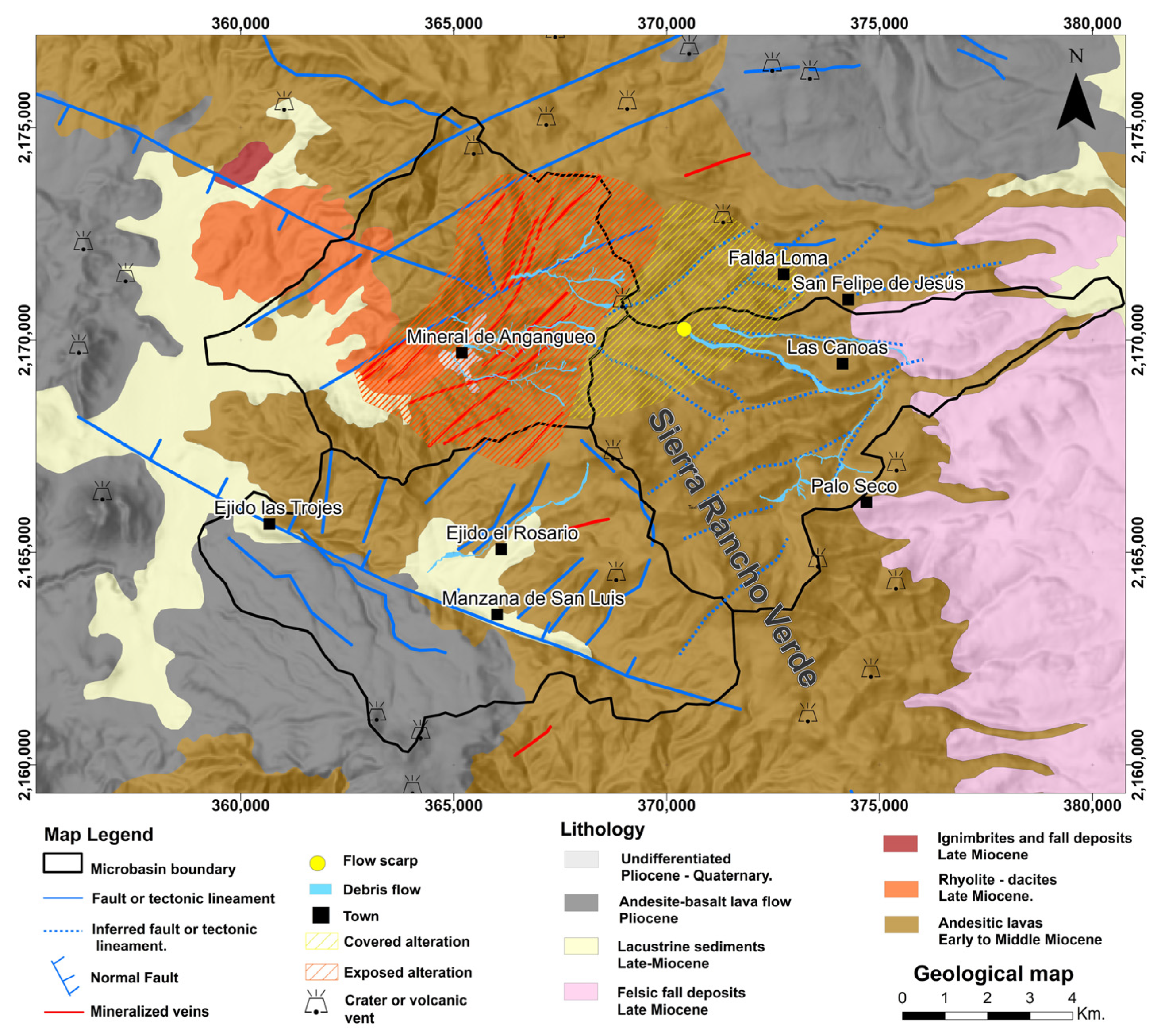
The study area contains two normal fault systems that are indicative of brittle deformation. The first system trends NW-SE, as shown by volcanic structures aligned along NNW-SSE structural lineaments (Figure 2, blue lines). The second fault system, which trends NE-SW, is observed in the Angangueo area and contains mineralized veins (Figure 2, red lines).
The mineralized veins are a result of hydrothermal activity, which is a factor contributing to rock instability in the region. This vein-type mineralization system is associated with high-angle faults, resulting in mesothermal, lenticular ore bodies that vary in thickness along their length [25]. Analysis of fluid inclusions from the Sierra de Angangueo mineralized veins indicate homogenization temperatures ranging from 240 °C to 348 °C, corresponding to argillic, sericitic, and phyllic alteration processes [25]. Another factor contributing to slope instability in the area is deforestation and mining activities [29].

2.2. Local Geology

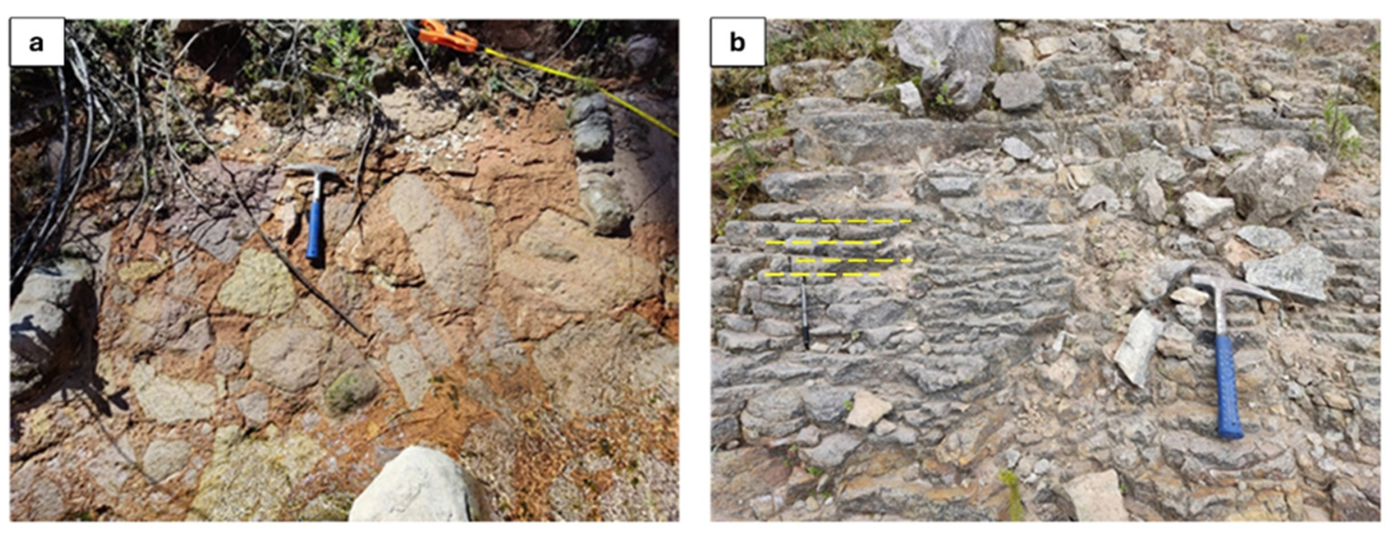
The lithological sequence from which the Canoas debris flow originated consists of two units. At the base lies a ~9 m thick red andesitic breccia. This unit shows significant oxidation due to intense hydrothermal alteration and is made up of andesite fragments displaying gray, yellow, pink, and red hues. The fragments are predominantly subangular to subrounded in shape, with sizes ranging from 5 cm to 45 cm along their longest dimension. These rocks are characterized by phenocrysts of plagioclase, biotite, hornblende, and orthopyroxene, all embedded in a highly argillized matrix. Above this unit is a jointed, light gray andesite that has an approximate thickness of 12 m and exhibits relatively low degrees of alteration. This layer corresponds to a lava flow that was emplaced over the paleo-topography formed by the underlying andesitic breccia (Figure 2).

2.3. Climate Conditions

The Sierra de Angangueo is influenced by a seasonal rainfall regime that extends from May to October and is strongly controlled by orographic effects. Warm and humid air masses rising over the mountainous relief generate intense summer precipitation. However, extraordinary rainfall events have also been recorded outside this typical season, often associated with large-scale climatic forcings such as El Niño. A notable case occurred in February 2010, when the combined effect of cold fronts, winter storms, and an El Niño event produced atypical precipitation, accompanied by hail accumulations up to 0.5 m in thickness.
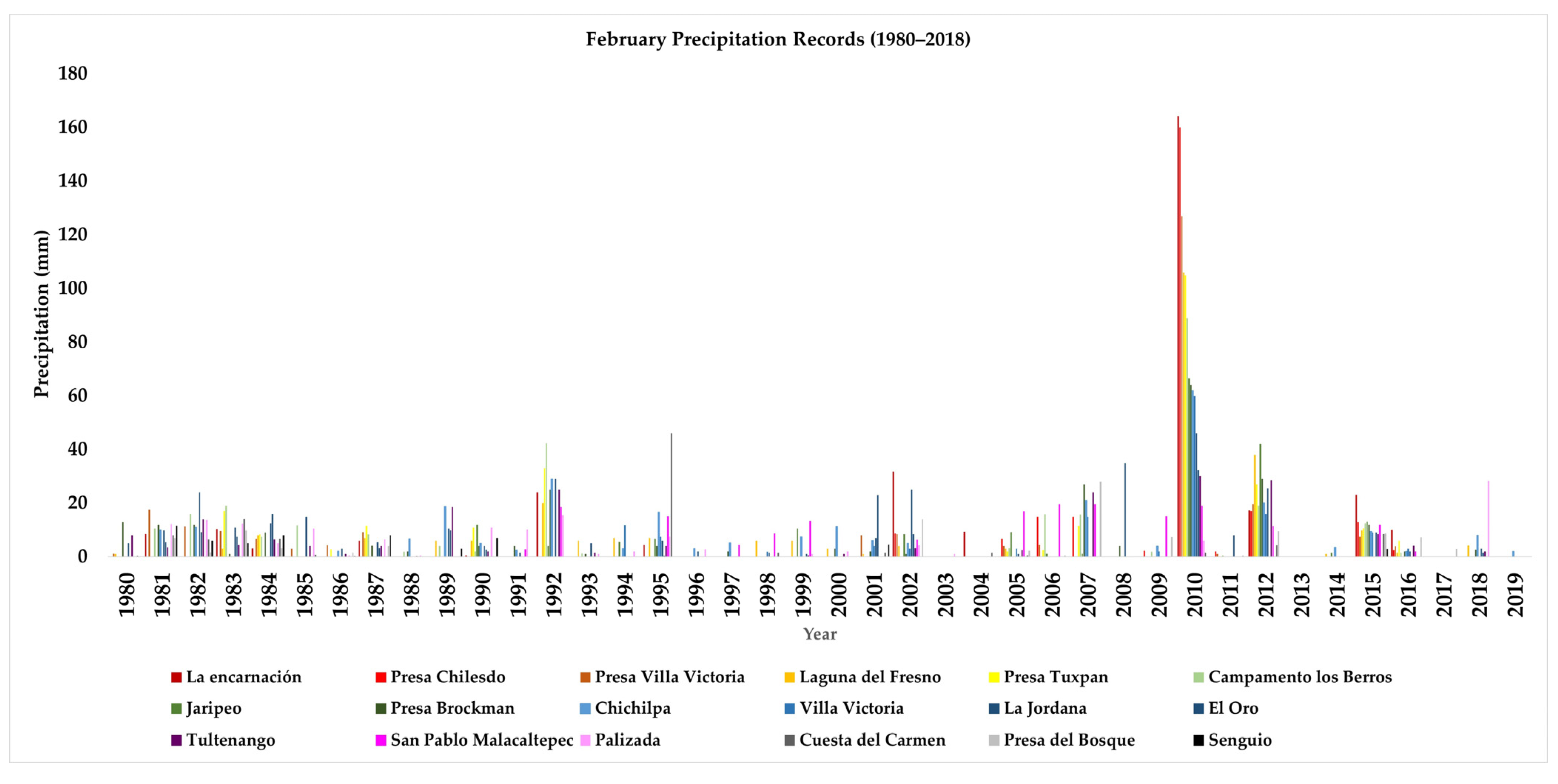
Data from 18 climatological stations operating within a 35 km radius indicate that rainfall during this event exceeded 800% of historical February maxima. Daily values reached 160 mm in 24 h, far above the ~20 mm expected for this month, and cumulative rainfall between January 1 and February 6 totaled nearly 300 mm (Figure 3). This intense precipitation led to progressive soil saturation, loss of intergranular cohesion, and the development of highly unstable conditions favorable for debris-flow initiation.
Spatial and temporal analysis shows that extreme rainfall events in the Sierra are typically concentrated in the western sector; however, in 2010 precipitation extended eastward, covering a much larger area than usual and directly affecting the Canoas catchment. For the Trans-Mexican Volcanic Belt, the rainfall thresholds proposed by Centro Nacional de Prevencion de Desastres (CENAPRED) for landslide triggering are 117.07 mm (medium), 175.61 mm (high), and 234.14 mm (very high) in 24 h [30]. The 2010 event clearly surpassed these thresholds, demonstrating its extraordinary nature.
Overall, the climate regime of the Sierra de Angangueo is defined by intense seasonal rainfall but is highly vulnerable to anomalous precipitation linked to global climatic forcings, particularly El Niño [31]. These events significantly increase the frequency and magnitude of hydrometeorological extremes and thus play a key role in conditioning slope instability and debris-flow hazards in the region.

2.4. Description of Landslide

The landslide in Rancho Verde Sierra took place on the morning of 4 February 2010, following five consecutive days of rainfall that totaled 237 mm (La Encarnación weather station), [32]. The higher elevations of Sierra de Angangueo were also impacted by hail, creating a ≥0.5 m thick layer.
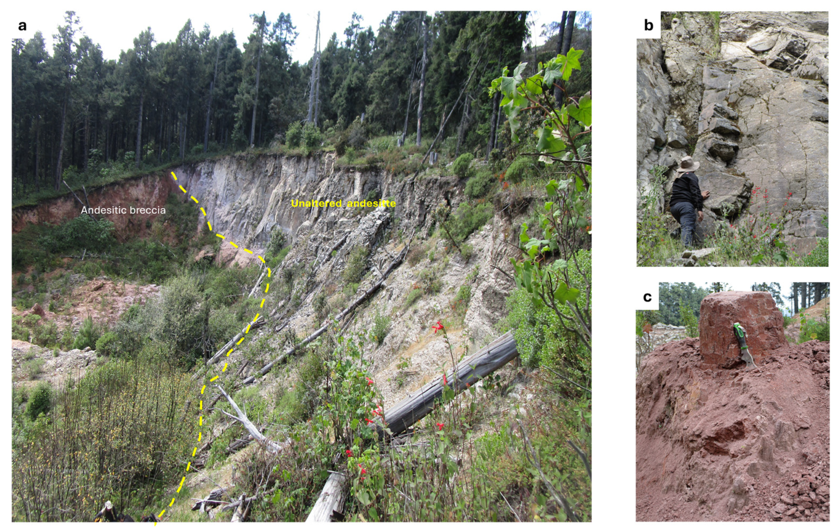
The excessive rainfall and hail triggered the Canoas debris flow, which originated at an elevation of 3415 m. The area of detachment contains a 20 m vertical scarp that dips 85° toward the southeast, exposing the two previously described lithological units (Figure 4). Tension cracks are present at the top of the scarp and indicate decompression caused by the loss of material on the slope.
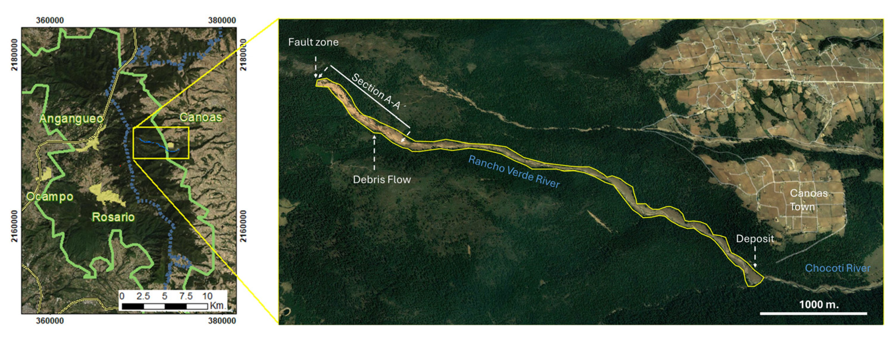
The debris flow was channeled into the Rancho Verde River, significantly altering its morphology and morphometry. The river’s initial width of 2 m was locally expanded to as much as 20 m. The debris flow deposits consist of heterogeneous rock and plant fragments ranging in size from 4 mm to 1.0 m, supported by a matrix of finer sediments (less than 0.004 m in size). The debris flow traveled 3.8 km down the Ranche Verde river before reaching the confluence with the Chocoti River (Figure 5), where the greatest accumulation of sediment occurred. Significant forest mass location along the flow path was incorporated into the debris flow and became part of the deposit.
The stratigraphic sequence forming the slope was exposed by the debris flow, with the andesitic breccia at the base overlain by more recent andesitic lava flows (Figure 6).

2.5. Methodology

Rock samples of the hydrothermally altered andesite breccia and relatively unaltered andesite were collected and analyzed from the landslide scarp to measure key properties, including real density (ρr), porosity (η), permeability (k), uniaxial compressive strength (σ max) and indirect tensile strength (σT). We performed petrographic analysis to identify the paragenesis of primary and secondary minerals. Based on the physical characteristics of the altered samples (specifically their low cohesion when wet and brittle behavior), sieve analysis was performed to determine the complete grain-size distribution.

Field Work and Sampling

The sampling consisted of collecting one block of the unaltered andesite and one block of the altered andesitic breccia, each with a minimum dimension of 30 cm × 30 cm × 30 cm. From these blocks, 21 cylindrical specimens were prepared in accordance with ASTM D4543-19 [33] standards: thirteen from the un-weathered andesite rock and eight from the altered andesitic breccia. The unaltered andesite sample, (CAR-1) was collected from the upper part of the scarp and the altered andesite breccia sample (CAR-2) was obtained from the base of the scarp (Figure 7 and Table 1).
All samples were collected during the same field campaign, ensuring homogeneity in their initial conditions. Subsequently, all laboratory tests were carried out under controlled environmental conditions, maintaining an average temperature of 23 ± 2 °C, an atmospheric pressure of approximately 101 kPa, and a relative humidity of 45–55%. These values are consistent with standard laboratory practices for testing competent rock materials, ensuring specimen stability and comparability of results.
Five thin sections were prepared from subsamples of the collected blocks—two from the altered andesitic breccia and three from the unaltered andesite. Thin sections were cut to the standard petrographic dimensions of 27 × 46 mm with a thickness of 30 µm. Due to the lack of cohesion in the altered rock, these samples were encapsulated in epoxy resin prior to thin-section preparation. The epoxy was cured at room temperature (~22 °C) for 24 h, ensuring consistency across all samples. This procedure enabled the identification of mineral components even if they were no longer in their original position.
Density was determined following the methodology outlined in ASTM D5550-23 [34], using an automated gas pycnometer (Quantachrome, Ultrapyc 1200e, Boynton Beach, FL, USA) to measure specific gravity—a parameter used for determining the relative volumes of particles, water, and gas mixtures. Solid density was obtained by introducing high-purity helium into a one inch long and one inch diameter rock cylinder.
Porosity was determined by mercury intrusion porosimetry (MIP) using a Quantachrome PoreMaster-33, which measures pore volumes in the range of 1000 µm to 0.0070 µm (70 Å). In this study, a maximum pressure of 210 MPa was applied. This value was selected to resolve the finer pore entry diameters while remaining below the instrument’s operational limit (231 MPa). No evidence of pore collapse or damage was observed in the relatively unaltered andesite (CAR-1), confirming that the applied conditions were appropriate for competent volcanic rock.
In contrast, MIP was not applied to the highly altered andesitic breccia (CAR-2) due to its low cohesion and soil-like behavior, which increases the likelihood of pore collapse or disintegration under high intrusion pressures. Instead, CAR-2 was characterized by grain-size distribution and Atterberg limits, providing a more representative description of its mechanical properties and its response to water saturation.
A permeability test was conducted according to the procedures outlined in ASTM D4525-13e2 [35] and the criteria established by [36]. Permeability values were measured using the GasPerm AP-123-002-0 (Vinci Technology: Nanterre, France) device, which is specifically designed to assess gas permeability under steady-state conditions, maintaining constant pressure and flow through the sample. The results were derived from Darcy’s Law, assuming horizontal laminar flow of an ideal gas under isothermal and steady-state conditions.
Since both strength and deformability govern mechanical behavior, standardized procedures were applied to determine these properties, following ASTM D3967-23 [37], ASTM D2938-95 [38], and ASTM D7012-23 [39]. These standards provide guidelines for conducting uniaxial compressive strength (UCS) and indirect tensile strength tests (the Brazilian test). Uniaxial compressive strength is the most used parameter to define failure criteria and the geomechanical behavior of a rock mass.
Porosity and pore size are also critical parameters, as they significantly influence the behavior of materials under compressive and tensile stress [40,41,42,43,44]. For the tests mentioned above, we utilized a GDSVIS 250 kN infinite virtual stiffness loading press, which applied a constant displacement of 4 mm/h. This setup enabled the construction of stress–strain curves, from which we calculated elastic moduli (including Young’s modulus and Poisson’s ratio).
The indirect tensile strength test was performed using a GCTS RIT-B-NX instrument, following the guidelines of ASTM D3967-23 [37]. Deformation measurements were taken using linear variable displacement transducers (LVDTs) positioned perpendicular to the applied load.
Due to the highly brittle nature of the altered andesitic breccia when wet, it was not possible to conduct permeability and porosity tests. Consequently, grain-size distribution was analyzed instead. In its dry state, this rock exhibits high particle cohesion, providing greater strength and competence, which makes it difficult to disaggregate. However, when hydrated, this cohesion is lost, leading to the disintegration of particles. Given these characteristics, wet sieving was employed for grain-size analysis.

3. Results

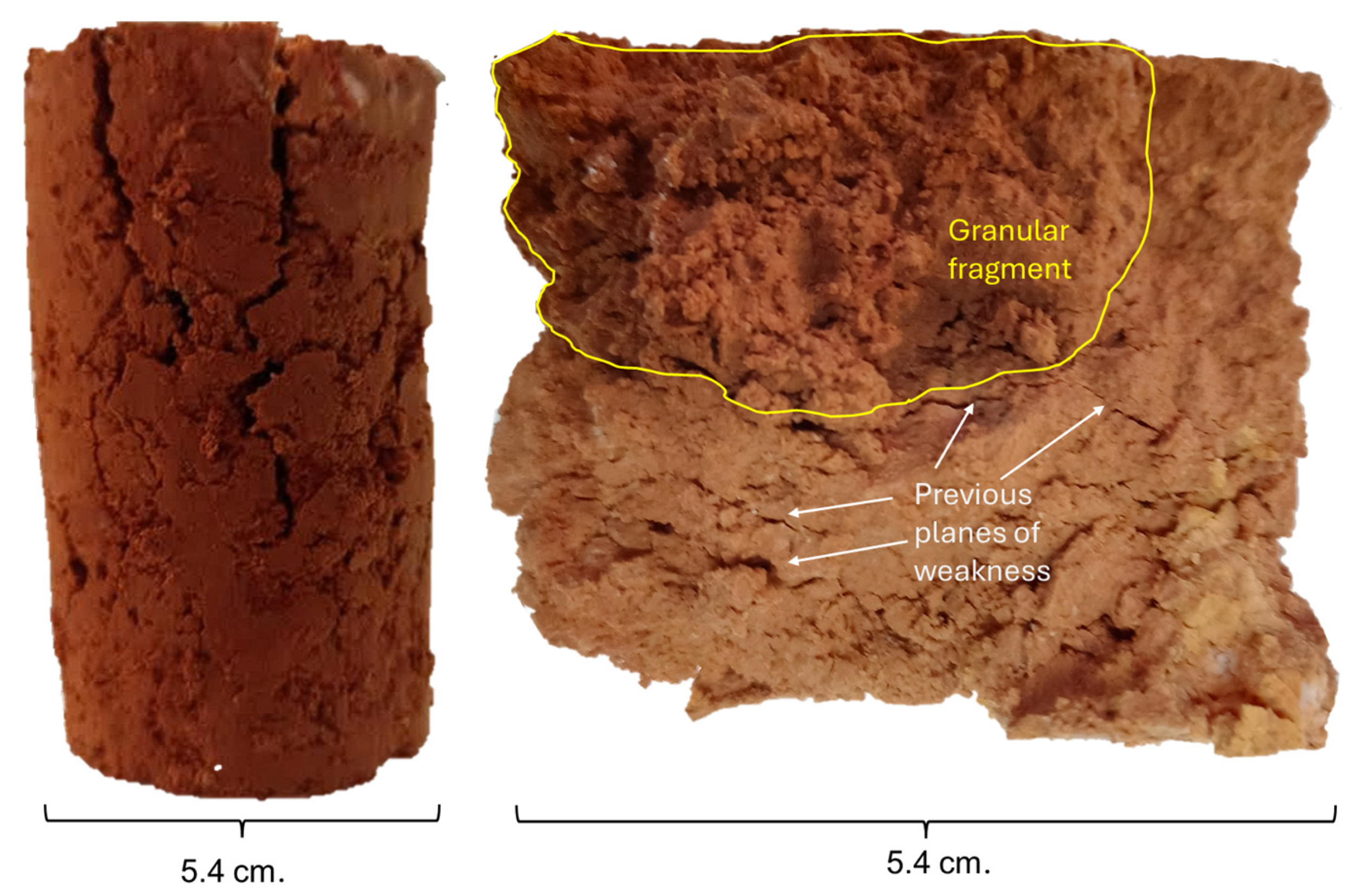
The unaltered andesite sample (CAR-1) exhibited significantly higher uniaxial compressive strength values compared to the altered andesitic breccia sample (CAR-2). However, due to the condition of the altered sample (CAR-2), it was not possible to prepare cylindrical specimens of adequate quality and dimensions for certain tests, such as permeability and porosity (Figure 8 and Table 2). Nonetheless, the Atterberg limits were determined, providing valuable insights into the material’s behavior in relation to its moisture content [45].
After obtaining the grain-size distribution and Atterberg limits, the Unified Soil Classification System (USCS) was applied, as the altered andesitic breccia behaves similarly to soil. The obtained values for the liquid limit (wL), plastic limit (wP), and plasticity index (IP = wL − wP) indicated intermediate plasticity. They classified the material as a medium-compressibility silty soil (MH) and, in some cases, as sand with inorganic silt (SM). These results suggest that the mechanical behavior of the altered breccia is comparable to that of fine-grained soil, thereby justifying the use of geotechnical tools typically applied to soil characterization [46].
Furthermore, recent studies have shown that the Atterberg limits not only empirically describe the consistency of fine-grained soils but also correlate with the total amount of adsorbed water in the soil, which plays a key role in soil–water interaction and the mechanical response of the material. Zhou and Lu [45] analyzed an extensive soil database and found significant correlations between wL, wP, and IP values and the adsorbed water content determined through water retention curves. Their findings support the hypothesis that the Atterberg limits reflect fundamental physical properties of soils—such as specific surface area and adsorptive suction—rather than processes related to free or capillary water.
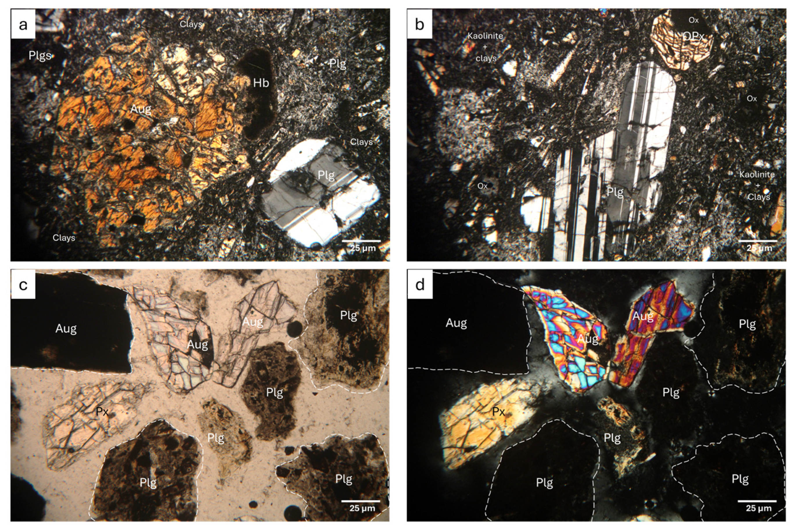
Sample CAR-1 (Figure 9a,b) exhibits the mineralogical characteristics of an andesite composed of plagioclase, orthopyroxene, and minor quartz phenocrysts. The plagioclase phenocrysts exhibit minor alteration to kaolinite and sericite and the orthopyroxenes are partially to completely replaced by clay minerals with abundant iron oxide. The groundmass displays a porphyritic texture, although trachytic textures are occasionally observed. Sample CAR-2 (Figure 9c,d) was encapsulated due to the advanced alteration of the rock. Only fragments of the original, rock-forming crystals are visible in thin section. These fragments include individual orthopyroxene crystals with moderate fracturing and iron oxide inclusions and plagioclase with moderate clay and oxide alteration. The finer particles, randomly distributed throughout the sample, comprise clays and micas.

4. Discussion

Clays are a significant factor in slope failures worldwide and are present in various rock types and environmental settings. Hydrothermal alteration of rocks in volcanic environments is common because of circulation of hot fluids through fracture networks [47]. This alteration weakens the rock mass and promotes the formation of clay minerals. An increase in pore pressure within these altered rock masses is considered a primary cause of slope instability in volcanic terrains [40,48]. Rock alteration decreases rock shear strength by reducing the cohesion between particles and compromising the integrity of contact surfaces, ultimately creating slip surfaces [49].
During the investigation of the Vajont landslide in Italy, researchers discovered that the clay layers interbedded within the limestone strata contained over 50% montmorillonite [50,51]. Similar cases involving andesitic rocks altered to montmorillonite (with particle sizes between 2 and 5 µm) have been reported in Hollóháza, within the Tokaj Mountains of Hungary, where landslides occurred in areas with hydrothermal vein systems [52]. At the Soufrière stratovolcano in Guadeloupe, located in the French Caribbean, hydrothermal alteration was a conditional factor contributing to multiple slope failures [53]. Additionally, Mount Ruapehu, a stratovolcano in New Zealand, has experienced at least six major collapses over the past 200,000 years that occurred along the margins of brecciated lava, intrusions, and dense lava flows, where advanced argillic alteration is common [47,54].
The unaltered and altered volcanic rocks in the source region of the Canoa debris flow display significantly different geomechanical characteristics. These differences include variations in permeability, stress–strain behavior, porosity, and compressive strength, all of which directly affect slope stability. As an example, the mechanical properties of the altered andesitic breccia being particularly significant. These materials behave similarly to soil; they become easily crumbled wet but exhibit greater strength when dry.
Laboratory analyses have offered valuable insights into the index properties that characterize the geomechanical conditions of rock mass. A rock’s strength is primarily affected by its degree of alteration, as well as its texture and structure. Many rocks display fractures that are not visible to the naked eye, resulting from the alteration of their constituent minerals, leading to increased porosity.
Table 3 presents the grain sizes and mechanical properties of the highly altered andesitic breccia (sample CAR-2). As a result of hydrothermal alteration, this rock unit consists of between 40% and 90% of silt- and clay-sized particles (Figure 8). These fine particles closely correlate with the natural moisture content (Wm) illustrated in Table 2. Matrix suction leads to variation in moisture and distribution of altered rock [55], which changes depending on the degree of saturation [56]. Heavy rainfall and low temperatures modify this suction stress, ultimately contributing to the slope’s instability.
The effective porosity and permeability values obtained from sample CAR-1 are consistent with those reported for moderately altered andesitic rocks in the Guadeloupe Archipelago in the Caribbean that range from 11.730 ± 5.040 (%) and 1.8 × 10⁻¹⁵ m2 for permeability, respectively [57]. In the case of sample CAR-2, permeability was not directly measured, nevertheless the material behaves as fine-grained soil (MH or SM) suggests that water flows through it may be slow. Thus, adsorbed water tends to reduce pore connectivity, which may lead to water accumulation in slope areas where this material is predominant, potentially contributing to increased pore water pressure.
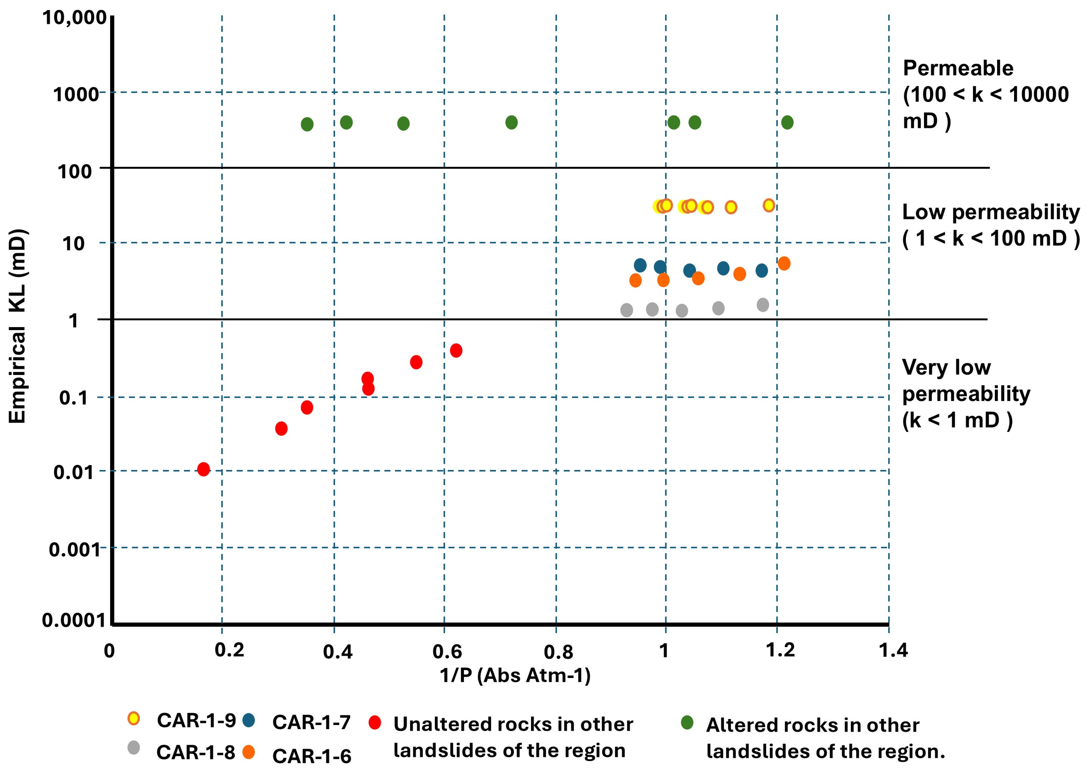
Benavente et al. (2015) [58] proposed a classification of rock permeability that includes four categories: very low permeability (k < 1 mD), low permeability (1 < k < 100 mD), permeable (100 < k < 10,000 mD) and highly permeable (k > 10,000 mD). Based on this classification, the CAR-1 samples, which are considered unaltered rocks, fall into the low permeability category. However, they are not the least permeable rocks in the region, as illustrated in Figure 10. Unaltered rocks sampled from older debris flow deposits, located 3.8 km southwest from the Canoas debris flow, exhibit very low permeability. These deposits, which are within the same mountain range, share a similar stratigraphy, consisting of younger andesitic lava flows overlying highly permeable altered andesite [43]. This lithology is comparable to the altered andesitic breccia found in Canoas, although it exhibits less oxidation.
The peak compressive strength values obtained for the unaltered andesite (sample CAR-1) are comparatively low relative to similar lithologies documented in previous studies [59]. The lower than expected strength is likely associated with the high degree of fracturing and the low to moderate degree of hydrothermal alteration affecting the rock, as evidenced by altered and micro-fractured crystals observed during petrographic examination. In contrast, the altered andesitic breccia (sample CAR-2) exhibits extremely low strength values that fall within the typical range for soils [46,60]. In fact, some soils have been reported to have higher compressive strength values than the altered andesitic breccia [43].
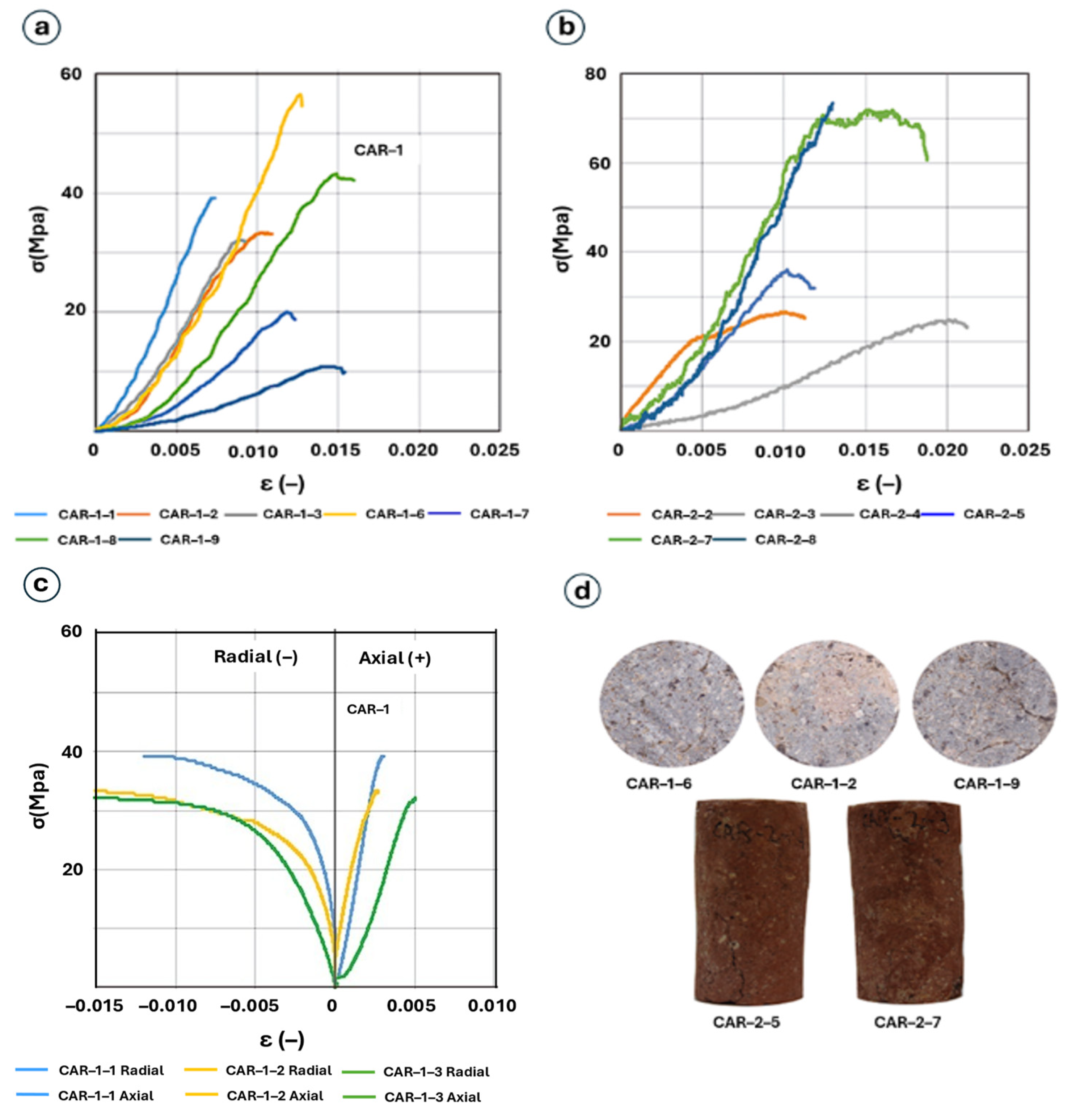
Figure 11 illustrates the compressive stress behavior of the CAR-1 and CAR-2 samples. The peak compressive strength of the relatively un-weathered andesite ranges from 10.92 to 56.57 MPa. As expected, the strength values correlate with porosity, particularly with the percentage of connected pores. The altered andesitic breccia exhibits significantly lower strength, comparable to that of soils, ranging from 0.26 to 0.86 MPa. In the stress–strain curves for intact and altered rocks (Figure 11a,b), lower strength values correspond to curves with gentler slopes. This geometry is quantitatively reflected in the elastic constants: Young’s modulus (E) and Poisson’s ratio (ν) for the unaltered andesite vary between 4 and 10.99 GPa and 0.27 to 0.35, respectively. In comparison, E for altered andesitic breccia is much lower, ranging from 0.02 to 0.1 GPa (Figure 11c). Poisson’s ratio could not be determined due to difficulties in installing local strain gauges (both axial and radial) on the relatively unconsolidated sample. Figure 11d provides an overview of the three textural characteristics observed in the unaltered andesite samples: massive, weathered patches, and microfractures. The failure mode of the altered andesitic breccia samples appears to be strongly influenced by the internal distribution of components within each sample. In contrast, existing fractures and their orientation relative to the loading direction play a dominant role in the failure behavior of the unaltered andesite (sample CAR-1).
Most landslides and slope failures occur on inclinations between 15° and 35° [61]. However, this is not a strict rule, as it depends on specific soil parameters and environmental conditions. The Canoas debris flow originated in an unstable zone due to hydrothermally altered subsurface rock (andesitic breccia; Figure 12). This altered rock, being highly friable, exhibits physical and mechanical behaviors more analogous to soil than rock. Particles smaller than 2 mm predominate, and in some cases, particles finer than 0.074 mm comprise up to 90% of the sample. Zelenka et al. (2005) [52], reported similar behavior in altered andesites, noting grain sizes between 2 and 5 µm, which correspond to high clay contents. The altered andesite samples described by [52] also exhibit high moisture content, which significantly reduces the strength of the rock and correlates to a high proportion of clay minerals [62,63,64] described two landslides in northwestern Italy that occurred under similar conditions in January 1991. These landslides were associated with rainfall, low temperatures, and accumulated snow, which obstructed water drainage due to freezing. This led to an increase in the piezometric level and higher pore pressure, ultimately triggering mass movement.
According to eyewitness accounts, the Sierra de Angangueo was covered by 50 cm of hail in early February 2010. This event likely altered the permeability and porosity of the altered rock, modifying the usual groundwater discharge points that had previously maintained slope stability.
These groundwater discharge points, such as those shown in Figure 12, are critical because they regulate subsurface water flow and pressure along hillslopes. In many mountainous terrains, stable discharge zones help relieve hydrostatic pressure and prevent water accumulation within slope materials. When these discharge points become obstructed or diverted—as can occur due to surface sealing or compaction—groundwater may begin to accumulate within the slope mass, increasing pore pressure and reducing effective stress [53,65,66]. This destabilization mechanism can significantly increase the likelihood of slope failure, particularly in terrains that have been previously weakened by hydrothermal alteration or intense fracturing, as is the case in Canoas.

5. Conclusions

The Canoas debris flow was strongly influenced by the presence of hydrothermally altered rock and the contrast in permeability and compressive strength between the altered rock and adjacent unaltered rock units. The unaltered rock is an andesite that exhibits minor argillic alteration (sericite and kaolinite) in its groundmass and constituent crystals. The hydrothermally altered rock is an andesitic breccia that contains dark clays distributed throughout the matrix and partially overlaying mineral grains. The grain size distribution of the altered rock reveals compositional variability, indicating a heterogeneous material that has mechanical properties more common in soils than rock. The unaltered andesite exhibits low porosity and low moisture content, implying a reduced water retention capacity, which decreases the likelihood of pore pressure buildup during rainfall or infiltration events, thereby enhancing slope stability. In contrast, the altered andesitic breccia exhibits higher porosity and moisture content due to its grain size characteristics, making it more prone to water saturation, which reduces effective stress and increases the likelihood of slope failure. Furthermore, internal erosion may occur due to pore connectivity, facilitating the loss of fine material and weakening the slope base.
The differences in the mechanical behavior between the unaltered and altered rock samples are attributed to their physical properties and the environmental conditions they are exposed to. The unaltered rock permeability values fall within the low permeability range, primarily influenced by the fracture content in each specimen. The unaltered rock also has relatively higher compressive strength and exhibits sufficient mechanical resistance to withstand significant stress without fracturing. On the other hand, the extremely low compressive strength of the altered andesitic breccia suggests a material highly susceptible to collapse under minimal loading conditions.
According to the location of the Canoas debris flow within the volcanic environment, as the TMVB, the hydrothermal alteration in the region plays an important role due to the unrevealed altered rocks caused by the juxtaposition of recent volcanism, which directly impacts the mechanical behavior of slopes. The key factor that triggered the Canoas debris flow in the headwaters of the Rancho Verde River was the presence of hydrothermally altered rock with weak geomechanical properties, incapable of maintaining slope stability. Consequently, atypical rainfall events could easily alter the basal material’s properties, ultimately generating the debris flow.

Author Contributions

Conceptualization, L.Á.J.L. and J.M.S.N.; methodology, L.Á.J.L., A.P. and H.I.S.; validation, L.Á.J.L., J.C.E.C. and P.R.C.; writing—original draft preparation, L.Á.J.L. and J.M.S.N.; writing—review and editing, L.Á.J.L., J.M.S.N., J.C.E.C., P.R.C. and M.E.S.F. All authors have read and agreed to the published version of the manuscript.

Funding

This research received no external funding.

Data Availability Statement

The original contributions presented in this study are included in the article. Further inquiries can be directed to the corresponding author.

Acknowledgments

The authors sincerely thank James B. Chapman for reviewing the text, Guillermo Cisneros for his assistance and support during the field campaigns, and the reviewers of this manuscript for their valuable and insightful comments. The authors also acknowledge SECIHTI for its support through a graduate scholarship.

Conflicts of Interest

The authors declare no conflicts of interest.

References

  1. Froude, M.J.; Petley, D.N. Global fatal landslide occurrence from 2004 to 2016. Nat. Hazards Earth Syst. Sci. 2018, 18, 2161–2181. [Google Scholar] [CrossRef]
  2. Marin, R.J.; García, E.F.; Aristizábal, E. Effect of basin morphometric parameters on physically-based rainfall thresholds for shallow landslides. Eng. Geol. 2020, 278, 105855. [Google Scholar] [CrossRef]
  3. Chaithong, T. Assessing the impact of climate change on landslide recurrence intervals in Nakhon Si Thammarat Province, Thailand, using CMIP6 climate models. Prog. Disaster 2024, 22, 100330. [Google Scholar] [CrossRef]
  4. Modugno, S.; Johnson, S.C.M.; Borrelli, P.; Alam, E.; Bezak, N.; Balzter, H. Analysis of human exposure to landslides with a GIS multiscale approach. Nat. Hazards 2022, 112, 387–412. [Google Scholar] [CrossRef]
  5. Díaz, S.R.; Cadena, E.; Adame, S.; Dávila, N. Landslides in Mexico: Their occurrence and social impact since 1935. Landslides 2020, 17, 379–394. [Google Scholar] [CrossRef]
  6. Macías, J.L. Geología e historia eruptiva de algunos de los grandes volcanes activos de México. Bol. Soc. Geol. Mex. 2005, 57, 379–424. [Google Scholar] [CrossRef]
  7. Frolova, J.V.; Ladygin, V.M.; Rychagov, S.N. Petrophysical Alteration of Volcanic Rocks in Hydrothermal Systems of the Kuril-Kamchatka Island Arc. In Proceedings of the World Geothermal Congress 2010, Bali, Indonesia, 25–29 April 2010; Available online: https://www.researchgate.net/publication/268266181_Petrophysical_Alteration_of_Volcanic_Rocks_in_Hydrothermal_Systems_of_the_Kuril-_Kamchatka_Island_Arc (accessed on 10 May 2024).
  8. Siratovich, P.A.; Heap, M.J.; Villeneuve, M.C.; Cole, J.W.; Kennedy, B.M.; Davidson, J.; Reuschl’e, T. Mechanical behaviour of the Rotokawa Andesites (New Zealand): Insight into permeability evolution and stress-induced behaviour in an actively utilised geothermal reservoir. Geothermics 2016, 64, 163–179. [Google Scholar] [CrossRef]
  9. Kennedy, B.M.; Farquhar, A.; Hilderman, R.; Villeneuve, M.C.; Heap, M.J.; Mordensky, S.; Kilgour, G.; Jolly, A.; Christenson, A.; Reuschl’e, R. Pressure controlled permeability in a conduit filled with fractured hydrothermal breccia reconstructed from Ballistics from Whakaari (White Island), New Zealand. Geosciences 2020, 10, 138. [Google Scholar] [CrossRef]
  10. Heap, M.J.; Kennedy, B.M.; Farquharson, J.I.; Ashworth, J.; Mayer, K.; Letham-Brake, M.; Reuschl’e, T.; Gilg, H.A.; Scheu, B.; Lavall’ee, Y.; et al. A multidisciplinary approach to quantify the permeability of the Whakaari/White Island volcanic hydrothermal system (Taupo Volcanic Zone, New Zealand). J. Volcanol. Geotherm. Res. 2017, 332, 88–108. [Google Scholar] [CrossRef]
  11. Farquharson, J.I.; Wild, B.; Kushnir, A.R.L.; Heap, M.J.; Baud, P.; Kennedy, B. Acid-induced dissolution of andesite: Evolution of permeability and strength. J. Geophys. Res. Solid Earth 2019, 124, 257–273. [Google Scholar] [CrossRef]
  12. Callahan, O.A.; Eichhubl, P.; Olson, J.E.; Davatzes, N.C. Fracture mechanical properties of damaged and hydrothermally altered rocks, Dixie Valley-Stillwater fault zone, Nevada, USA. J. Geophys. Res. Solid Earth 2019, 124, 4069–4090. [Google Scholar] [CrossRef]
  13. Cassidy, M.; Manga, M.; Cashman, K.; Bachmann, O.; Loewen, M. Controls on explosive-effusive volcanic eruption styles. Nat. Commun. 2018, 9, 2839. [Google Scholar] [CrossRef]
  14. Heap, M.J.; Troll, V.R.; Kushnir, A.R.; Gilg, H.A.; Collinson, A.S.; Deegan, F.M.; Darmawan, H.; Nadhirah Seraphine, N.; Neuberg, J.; Walter, T.R. Hydrothermal alteration promotes rapid pore-pressure rise and explosive eruption in silicic systems. Geophys. Res. Lett. 2019, 46, 17–18. [Google Scholar] [CrossRef]
  15. Mordensky, S.P.; Heap, M.J.; Kennedy, B.M.; Villeneuve, M.C.; Gravley, D.M.; Farquharson, J.I.; Reuschl’e, T. Influence of alteration on the mechanical behaviour and failure mode of andesite: Implications for shallow seismicity and volcano monitoring. Bull. Volcanol. 2019, 81, 44. [Google Scholar] [CrossRef]
  16. Reid, M.E.; Sisson, T.W.; Brien, D.L. Volcano collapse promoted by hydrothermal alteration and edifice shape, Mount Rainier, Washington. Geology 2001, 29, 779–782. [Google Scholar] [CrossRef]
  17. Coggan, J.S.; Stead, D.; Howe, J.H.; Faulks, C.I. 2013. Mineralogical controls on the engineering behavior of hydrothermally altered granites under uniaxial compression. Eng. Geol. 2013, 160, 89–102. [Google Scholar] [CrossRef]
  18. Villeneuve, M.; Kennedy, B.; Gravley, D.; Mordensky, S.; Heap, M.J.; Siratovich, P.; Wyering, L.; Cant, J. Characteristics of altered volcanic rocks in geothermal reservoirs. In Rock Mechanics for Natural Resources and Infrastructure Development; Da Fontoura, S.A.B., Rocca, R.J., Mendoza, J.F.P., Eds.; CRC Press: Boca Raton, FL, USA, 2019. [Google Scholar] [CrossRef]
  19. Heap, M.J.; Baumann, T.S.; Rosas-Carbajal, M.; Komorowski, J.-C.; Gilg, H.A.; Villeneuve, M.; Moretti, R.; Baud, P.; Carbillet, L.; Harnett, C.; et al. Alteration-induced volcano instability at La Soufri’ere de Guadeloupe (Eastern Caribbean). J. Geophys. Res. Solid Earth 2021, 126, e2021JB022514. [Google Scholar] [CrossRef]
  20. John, D.A.; Sisson, T.W.; Breit, G.N.; Rye, R.O.; Vallance, J.W. Characteristics, extent and origin of hydrothermal alteration at Mount Rainier Volcano, Cascades Arc, USA: Implications for debris-flow hazards and mineral deposits. J. Volcanol. Geotherm. Res. 2008, 175, 289–314. [Google Scholar] [CrossRef]
  21. Tamura, E.; Shuichi Hasegawa, S.; Watanabe, H.; Miyata, K.; Yatabe, R.; Uchida, J. Effect of Hydrothermal Alteration on landslides along the Median Tectonic Line. J. Jpn. Landslide Soc. 2007, 44, 222–236. [Google Scholar] [CrossRef]
  22. Alcántara-Ayala, I.; López-García, J.; Garnica, R.J. On the landslide event in 2010 in the Monarch Butterfly Biosphere Reserve, Angangueo, Michoacán, Mexico. Landslides 2012, 9, 263–273. [Google Scholar] [CrossRef]
  23. Diario Oficial de la Federación, Declaratoria de Desastre Natural Por la Ocurrencia de Lluvias Severas los Días 3 y 4 de Febrero, en 5 Municipios del Estado de Michoacán de Ocampo. 2010. Available online: https://dof.gob.mx/nota_detalle.php?codigo=5131662&fecha=12/02/2010#gsc.tab=0 (accessed on 6 September 2024).
  24. Li, Y.; Mo, P. A unified landslide classification system for loess slopes: A critical review. Geomorphology 2019, 340, 67–83. [Google Scholar] [CrossRef]
  25. Ostrooumov, M. Mineralogía de los Yacimientos Hidrotermales de Mediana Temperatura en Angangueo, Michoacán, México. Available online: www.researchgate.net/publication/269986955 (accessed on 10 November 2023).
  26. Ferrari, L.; Orozco-Esquivel, T.; Manea, V.; Manea, M. The dynamic history of the Trans-Mexican Volcanic Belt and the Mexico subduction zone. Tectonophysics 2012, 522–523, 122–149. [Google Scholar] [CrossRef]
  27. Pasquarè, G.; Ferrari, L.; Garduño-Monroy, V.H.; Tibaldi, A.; Vezzoli, L. Geology of the central sector of the Mexican Volcanic belt, States of Guanajuato and Michoacán. GSA Map Chart Ser. MCH 1991, 72, 20. [Google Scholar]
  28. Hernández-Bernal, M.d.S.; Corona-Chávez, P.; Solís-Pichardo, G.; Schaaf, P.; Solé-Viñas, J.; Molina, J.F. Miocene andesitic lavas of Sierra de Angangueo: A petrological, geochemical, and geochronological approach to arc magmatism in Central Mexico. Int. Geolg Rev. 2016, 58, 603–625. [Google Scholar] [CrossRef]
  29. López-García, J.; Alcántara-Ayala, I. Land-use change and hillslope instability in the monarch butterfly biosphere reserve, central Mexico. Land. Degrad. Dev. 2012, 23, 384–397. [Google Scholar] [CrossRef]
  30. Morales, D.L.; Castañeda, M.A.; González, H.A.E. Análisis de Umbrales de Lluvia Que Detonan Deslizamientos y Sus Posibles Aplicaciones en un Sistema de Alerta Temprana Por Inestabilidad de Laderas. 2016. Available online: http://www1.cenapred.unam.mx/COORDINACION_ADMINISTRATIVA/SRM/FRACCION_XLI_A/23.pdf (accessed on 12 March 2024).
  31. Emberson, R.; Kirschbaum, D.; Stanley, T. Global connections between El Nino and landslide impacts. Nat. Commun. 2021, 12, 1–11. [Google Scholar] [CrossRef]
  32. SMN, Servicio Metereológico Nacional. Available online: https://smn.conagua.gob.mx/es/climatologia/informacion-climatologica/informacion-estadistica-climatologica (accessed on 13 January 2024).
  33. ASTM D4543-19; Standard Practices for Preparing Rock Core Specimens and Determining Dimensional and Shape Tolerances. ASTM International: West Conshohocken, PA, USA, 2019. Available online: https://store.astm.org/d4543-19.html (accessed on 17 July 2024).
  34. ASTM D5550-23; Standard Test Method for Specific Gravity of Soil Solids by Gas Pycnometer. ASTM International: West Conshohocken, PA, USA, 2023. Available online: https://store.astm.org/d5550-23.html (accessed on 17 July 2024).
  35. ASTM D4525-13e2; Standard Test Method for Permeability of Rocks by Flowing Air. ASTM International: West Conshohocken, PA, USA, 2013. Available online: https://store.astm.org/d4525-13e02.html (accessed on 17 July 2024).
  36. Sander, R.; Pan, Z.; Connell, L.D. Laboratory measurement of low permeability unconventional gas reservoir rocks: A review of experimental methods. J. Nat. Gas. Sci. Eng. 2017, 37, 248–279. [Google Scholar] [CrossRef]
  37. ASTM D3967-23; Standard Test Method for Splitting Tensile Strength of Intact Rock Core Specimens with Flat Loading Platens. ASTM International: West Conshohocken, PA, USA, 2016. Available online: https://store.astm.org/d3967-23.html (accessed on 17 July 2024).
  38. ASTM D2938-95; Standard Test Methods for Unconfined Compressive Strength of Intact Rock Core Specimens. ASTM International: West Conshohocken, PA, USA, 2002. Available online: https://store.astm.org/d2938-95.html (accessed on 17 July 2024).
  39. ASTM D7012-23; Standard Test Methods for Compressive Strength and Elastic Moduli of Intact Rock Core Specimens Under Varying States of Stress and Temperatures. ASTM International: West Conshohocken, PA, USA, 2023. Available online: https://store.astm.org/d7012-23.html (accessed on 17 July 2024).
  40. Heap, M.J.; Harnett, C.E.; Wadsworth, F.B.; Gilg, H.A.; Carbillet, L.; Rosas-Carbajal, M.; Komorowski, J.C.; Baud, P.; Troll, V.R.; Deegan, F.M.; et al. The tensile strength of hydrothermally altered volcanic rocks. J. Volcanol. Geotherm. Res. 2022, 428, 107576. [Google Scholar] [CrossRef]
  41. Knopp, J.; Steger, H.; Moormann, C.; Blum, P. Influence of Weathering on Pore Size Distribution of Soft Rocks. Geotech. Geol. Eng. 2022, 40, 5333–5346. [Google Scholar] [CrossRef]
  42. Jones, J.N.; Boulton, S.J.; Stokes, M.; Bennett, G.L.; Whitworth, M.R.Z. 30-year record of Himalaya mass-wasting reveals landscape perturbations by extreme events. Nat. Commun. 2021, 12. [Google Scholar] [CrossRef]
  43. Sánchez-Núñez, J.M.; Pola, A.; Cisneros, G.; Sereno, H.I.; Serrano-flores, M.E.; Jiménez, L.Á.; Rodríguez, P. Physical-mechanical behavior of fresh and completely altered rocks as an important factor of slope instability in the El Rosario Monarch Butterfly Sanctuary, Michoacán, Mexico. Rev. Mex. Cienc. Geológicas 2021, 38, 272–282. [Google Scholar] [CrossRef]
  44. Zhang, S.; Cao, K.; Wang, C.; Wang, X.; Deng, G.; Wei, P. Influence of the porosity and pore size on the compressive and splitting strengths of cellular concrete with millimeter-size pores. Constr. Build. Mater. 2020, 235, 117508. [Google Scholar] [CrossRef]
  45. Zhou, B.; Lu, N. Correlation between Atterberg Limits and Soil Adsorptive Water. J. Geotech. Geoenviron. Eng. 2021, 147, 04020162. [Google Scholar] [CrossRef]
  46. Avşar, E.; Ulusay, R.; Mutlutürk, M. An experimental investigation of the mechanical behavior and microstructural features of a volcanic soil (Isparta, Turkey) and stability of cut slopes in this soil. Eng. Geol. 2015, 189, 68–83. [Google Scholar] [CrossRef]
  47. Mordensky, S.P.; Villeneuve, M.C.; Kennedy, B.M.; Struthers, J.D. Hydrothermally induced edifice destabilisation: The mechanical behaviour of rock mass surrounding a shallow intrusion in andesitic lavas, Pinnacle Ridge, Ruapehu, New Zealand. Eng. Geol. 2022, 305, 106696. [Google Scholar] [CrossRef]
  48. Kereszturi, G.; Heap, M.; Schaefer, L.N.; Darmawan, H.; Deegan, F.M.; Kennedy, B.; Komorowski, J.C.; Mead, S.; Rosas-Carbajal, M.; Ryan, A.; et al. Porosity, strength, and alteration–Towards a new volcano stability assessment tool using VNIR-SWIR reflectance spectroscopy. Earth Planet. Sci. Lett. 2023, 602, 117929. [Google Scholar] [CrossRef]
  49. Yalcin, A. The effects of clay on landslides: A case study. Appl. Clay Sci. 2007, 38, 77–85. [Google Scholar] [CrossRef]
  50. Hendron, A.; Patton, F. Technical Report gl-85-5 the Vaiont Slide a Geotechnical Analysis Based on New Geologic Observations; US Army Corps of Engineers: Washington, DC, USA, 1985. [Google Scholar]
  51. Paronuzzi, P.; Bolla, A.; Pinto, D.; Lenaz, D.; Soccal, M. The clays involved in the 1963 Vajont landslide: Genesis and geomechanical implications. Eng. Geol. 2021, 294, 106376. [Google Scholar] [CrossRef]
  52. Zelenka, T.; Kovács-pálffy, P.; Trauer, N. The role of expanding clay minerals in mas s movements at hollóháza, tokaj mts. Acta Mineral. Petrogr. 2005, 46, 63–67. [Google Scholar]
  53. Heap, M.J.; Harnett, C.; Farquharson, J.; Baud, P.; Rosas-Carbajal, M.; Komorowski, J.C.; Violay, M.E.S.; Gilg, H.A.; Reuschlé, T. The influence of water-saturation on the strength of volcanic rocks and the stability of lava domes. J. Volcanol. Geotherm. Res. 2023, 444, 107962. [Google Scholar] [CrossRef]
  54. Miller, C.A.; Schaefer, L.N.; Kereszturi, G.; Fournier, D. Three-Dimensional Mapping of Mt. Ruapehu Volcano, New Zealand, from Aeromagnetic Dat Inversion and Hyperspectral Imaging. J. Geophys. Res. Solid Earth 2020, 125, e2019JB018247. [Google Scholar] [CrossRef]
  55. Ng, C.W.; Pang, Y.W. Influence of Stress State on Soil-Water Characteristics and Slope Stability. J. Geotech. Geoenviron. Eng. 2000, 126, 157–166. [Google Scholar] [CrossRef]
  56. Lu, N.; Likos, W.J. Suction Stress Characteristic Curve for Unsaturated Soil. J. Geotech. Geoenviron. Eng. 2006, 132, 131–142. [Google Scholar] [CrossRef]
  57. Navelot, V.; Géraud, Y.; Favier, A.; Diraison, M.; Corsini, M.; Lardeaux, J.; Verati, C.; Mercier, J.; Lépinay, D.; Legendre, L.; et al. Petrophysical properties of volcanic rocks and impacts of hydrothermal alteration in the Guadeloupe Archipelago (West Indies). J. Volcanol. Geotherm. Res. 2018, 360, 1–21. [Google Scholar] [CrossRef]
  58. Benavente, D.; Pla, C.; Cueto, N.; Galvañ, S.; Martínez-Martínez, J.; García-del-Cura, M.A.; Ordóñez, S. Predicting water permeability in sedimentary rocks from capillary imbibition and pore structure. Eng. Geol. 2015, 195, 301–311. [Google Scholar] [CrossRef]
  59. Pereira, M.L.; Zanon, V.; Fernandes, I.; Pappalardo, L.; Viveiros, F. Hydrothermal alteration and physical and mechanical properties of rocks in a volcanic environment: A review. Earth Sci. Rev. 2024, 252, 104754. [Google Scholar] [CrossRef]
  60. Kamal, A.S.M.M.; Hossain, F.; Rahman, M.Z.; Ahmed, B.; Sammonds, P. Geological and soil engineering properties of shallow landslides occurring in the Kutupalong Rohingya Camp in Cox’s Bazar, Bangladesh. Landslides 2022, 19, 465–478. [Google Scholar] [CrossRef]
  61. Çellek, S. Effect of the Slope Angle and Its Classification on Landslide. Himal. Geol. 2022, 43, 85–95. [Google Scholar] [CrossRef]
  62. Ma, S.; Yao, Y.; Bao, P.; Guo, C. Effects of moisture content on strength and compression properties of foundation soils of cultural relics in areas flooded by the Yellow River. Front. Mater. 2023, 10, 1186750. [Google Scholar] [CrossRef]
  63. Musta, B.; Karim, A.S.R.; Soehady, H.F.; Kim, K.W.; Kim, J.H. Effect of moisture on engineering properties of soil slopes from melange in Sandakan Sabah, Malaysia. ASM Sci. J. 2018, 11, 79–85. [Google Scholar]
  64. Govi, M.; Pasuto, A.; Silvano, S.; Siorpaes, C. An example of a low-temperature-triggered landslide. Eng. Geol. 1993, 36, 53–65. [Google Scholar] [CrossRef]
  65. Bogaard, T.A.; Greco, R. Landslide hydrology: From hydrology to pore pressure. Wiley Interdiscip. Rev. Water 2016, 3, 439–459. [Google Scholar] [CrossRef]
  66. Iverson, R.M. Landslide triggering by rain infiltration. Water Resour. Res. 2000, 36, 1897–1910. [Google Scholar] [CrossRef]
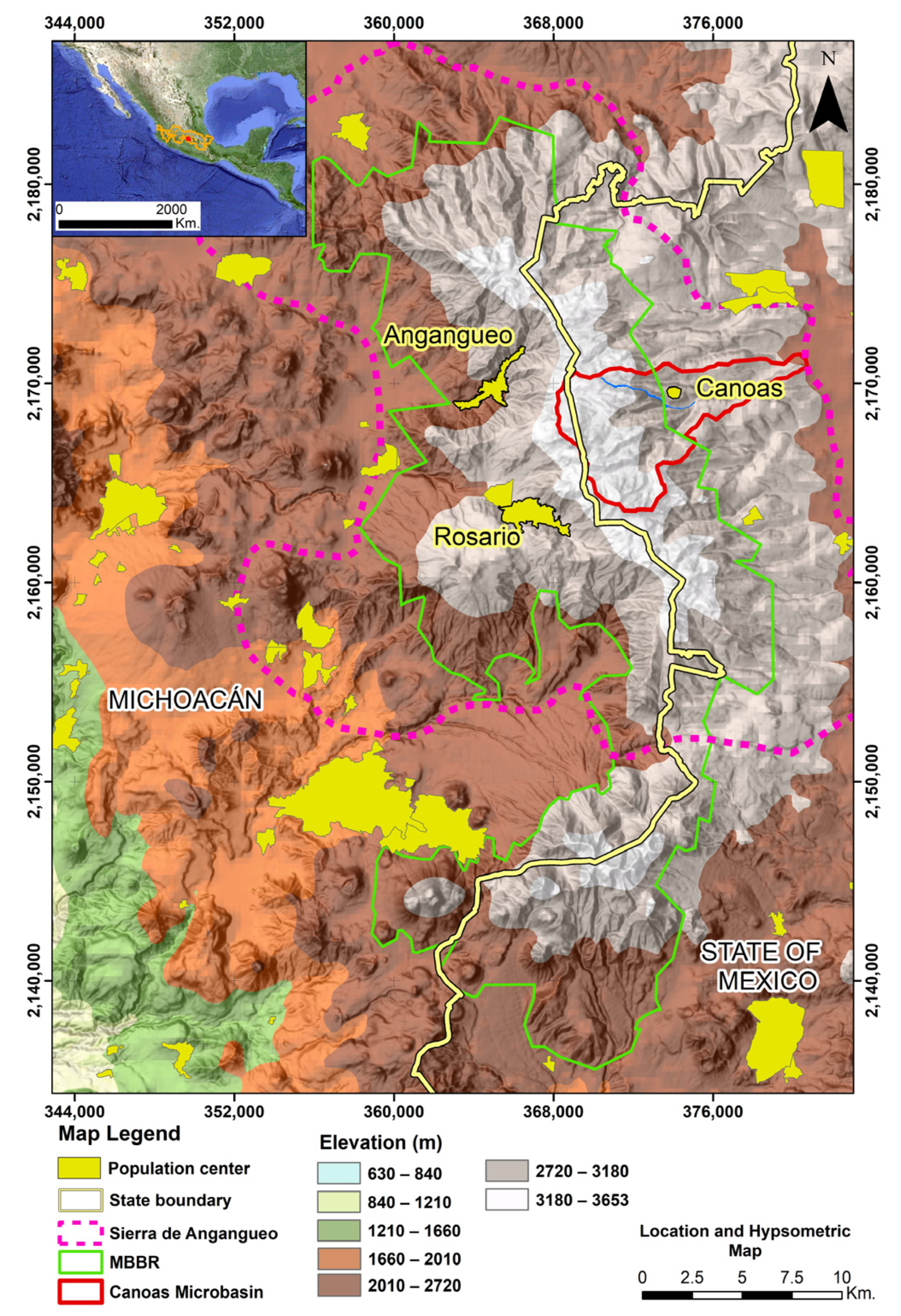
Figure 1. Location and hypsometric model of the study area. The high-altitude zones of the Sierra, where active landslides are occurring, are represented in shades of gray and white. Areas with settlements are shown in yellow. The red polygon outlines the boundary of the Canoas microbasin, while the green polygon indicates the Monarch Butterfly Biosphere Reserve (MBBR).
Geohazards 06 00062 g001
Figure 2. Simplified Geological Map of the Canoas Region (Modified from Hernández-Bernal et al., 2016) [28]). The red lines indicate the mineralized veins of the Angangueo district, which trend northeast-southwest (NE–SW). The orange polygon outlines an area of intense hydrothermal alteration that has led to the formation of Ag–Pb–Zn polymetallic ore deposits. The yellow polygon marks the alteration zones that are covered by more recent andesitic lava flows.
Geohazards 06 00062 g002
Figure 3. February precipitation records (1980–2018) obtained from multiple meteorological stations in the study area. The data illustrate interannual variability and highlight significant rainfall peaks, such as the extreme event in 2010.
Geohazards 06 00062 g003
Figure 4. Photomosaic looking northwest, illustrating the scarp of the detachment area that triggered the debris flow in the Rancho Verde Sierra. The two lithological units are visible: at the base is the hydrothermally altered andesitic breccia, and above it lies the relatively unaltered, jointed andesite.
Geohazards 06 00062 g004
Figure 5. Satellite images illustrating the development of the debris flow in the Rancho Verde River.
Geohazards 06 00062 g005
Figure 6. (a) A northwest-facing photograph showing the highly altered andesitic breccia with an oxidized matrix that contains andesite clasts up to 40 cm in diameter. Above this breccia, there is an older debris flow deposit. (b) A northwest-facing photograph showing the relatively unaltered light gray jointed andesite. Joints are indicated by dashed yellow lines and are spaced up to 5 cm apart.
Geohazards 06 00062 g006
Figure 7. (a) A southwest-facing photograph showing the detachment zone (scarp) that triggered the debris flow, revealing the lithological contact between jointed andesite and andesitic breccia. (b) A northeast-facing photograph of the CAR-1 sampling site showing un-weathered andesite with orthogonal fracture planes that resulted in wedge failures. (c) A north-facing photograph of the CAR-2 sampling site, showing the highly altered and oxidized, clay-rich andesitic breccia.
Geohazards 06 00062 g007
Figure 8. In the altered sample CAR-2, a cylindrical specimen was not able to be preserved due to a lack of cohesion.
Geohazards 06 00062 g008
Figure 9. Photomicrographs showing the characteristics of samples CAR-1 (a,b) and CAR-2 (c,d). Thin section photomicrographs using plain (a,b,d) and crossed (c) polarized light. (a) Augite (Aug) crystals exhibit intense fracturing and reaction rims associated with melt disequilibrium. (b) Tabular plagioclase (Plg) crystals with polysynthetic twinning; the groundmass contains a moderate amount of clay minerals (kaolinite and sericite), (c,d) Individual augite (Aug) crystals with moderate fracturing and iron oxide inclusions; plagioclase (Plg) with moderate clay minerals and oxides present.
Geohazards 06 00062 g009
Figure 10. Graph of empirical fluid permeability (mD) versus inverse mean pressure (1/Pmean [Abs Atm-1]). Flow mechanisms such as diffusion and dispersion are illustrated through the inverse mean pressure of five measurement points for each test. A color scale indicates the permeability range for different rock types. Colored circles highlight the permeability values from regional samples and the fresh rock samples (CAR-1) analyzed in this study, based on the permeability classification proposed by Benavente et al. (2015) [58].
Geohazards 06 00062 g010
Figure 11. Stress–strain curves for (a) unaltered andesite and (b) altered andesitic breccia. (c) Radial and axial stress–strain response of unaltered andesite samples. (d) Photographs of rock samples used for analysis. From left to right; massive unaltered andesite (CAR 1-6), unaltered andesite with alteration stains (CAR 1-2), unaltered andesite with microfractures (CAR 1-9), altered andesitic breccia (CAR 2-5 and CAR 2-7) cylinders shown, having been deformed to failure under uniaxial compressive strength tests.
Geohazards 06 00062 g011
Figure 12. A cross-section showing where the Canoas debris flow traversed the Rancho Verde River. The slope of the terrain is approximately 19°. The debris flow primarily moved over andesitic breccia, while some of the deposits remain in the jointed andesite zone. Location of cross-section shown in Figure 5.
Geohazards 06 00062 g012
Table 1. Identification of samples collected from the debris flow scarp in Canoas.
ID SampleCoordinates UTM Zone 14 N. (Meters)Description
XYZ
CAR-1370,394217,02763409Light gray andesite features vertical joints and areas of intense horizontal sheeting, alternating with a massive structure.
CAR-2370,398217,02463389Dark red andesitic breccia rich in iron oxide and highly argillically altered.
Table 2. Physical and mechanical properties for rock samples from the landslide scarp of the Canoas debris flow.
IDCAR-1CAR-2
Wm (%)1.9826.66
ρr (g/cm3)2.636 ± 0.0002.68 ± 0.00
ρbg (g/cm3)2.376 ± 0.0021.056 ± 0.002
ρbh (g/cm3)2.33 ± 0.003-
k (mD)1.82 ± 1.60-
k (m2)1.79619986 × 10⁻¹⁵-
Ht (%)11.730 ± 5.040-
ηe (%)8.40 ± 3.068-
ηC/ηT73.340 ± 18.30-
σt (MPa)3.860 ± 1.962-
σmax (MPa)36.26 ± 18.620.47 ± 0.05
E (GPa)4.916 ± 0.2570.046 ± 0.001
ν (−)0.313 ± 0.001-
Abbreviations: Wm = natural moisture content, ρr = true density, ρbg = apparent density by geometric method, ρbh = apparent density by hydrostatic method, k = permeability, ηt = porosity total, ηe = effective porosity, ηc/ηt = percentage of connected pores relative to total porosity, σt = indirect tensile strength, σmax = uniaxial compressive strength, E = elastic modulus, ν (−) = Poisson’s ratio, - = not obtained.
Table 3. Results of the grain-size distribution and Atterberg limits tests conducted on two specimens from the altered rock sample CAR-2. The symbol “#” refers to the sieve number.
Granulometry
Mesh Number #% Passing
CAR-2-1CAR-2-2
10 (2 mm)99.9797.34
20 (0.841 mm)99.6784.09
40 (0.4 mm)98.6468.82
60 (0.25 mm)97.0858.11
100 (0.149 mm)95.1748.41
200 (0.074 mm)92.4939.58
Atterberg Limits
Humidity %72.6364.5
Liquid Limit %97.9137.67
Plastic Limit %48.5330.58
Plastic Index %49.377.08
Lineal contraction %22.63.3
Classification (USCS)MHSM
Disclaimer/Publisher’s Note: The statements, opinions and data contained in all publications are solely those of the individual author(s) and contributor(s) and not of MDPI and/or the editor(s). MDPI and/or the editor(s) disclaim responsibility for any injury to people or property resulting from any ideas, methods, instructions or products referred to in the content.